PHASE I ENVIRONMENTAL SITE ASSESSMENT REPORT 3.3-ACRE ECKENRODE PROPERTY WARWICK TOWNSHIP, TUSCARAWAS COUNTY, OHIO. Prepared for: OHIOLAND, LLC
|
|
|
- Marianna Little
- 5 years ago
- Views:
Transcription
1 PHASE I ENVIRONMENTAL SITE ASSESSMENT REPORT 3.3-ACRE ECKENRODE PROPERTY WARWICK TOWNSHIP, TUSCARAWAS COUNTY, OHIO Prepared for: OHIOLAND, LLC Prepared by: CIVIL & ENVIRONMENTAL CONSULTANTS, INC. COLUMBUS, OHIO CEC Project November 25, 2013

2 November 25, 2013 Mr. Steve Mobley Ohioland, LLC 2205 Westover Road Austin, TX Dear Mr. Mobley: Subject: Report of Phase I Environmental Site Assessment 3.3-Acre Eckenrode Property Warwick Township, Tuscarawas County, Ohio CEC Project No Civil & Environmental Consultants, Inc. (CEC) is pleased to submit the attached Phase I Environmental Site Assessment (ESA) report for the above referenced Subject Property. This Phase I ESA was performed at your request in accordance with CEC s proposal, dated October 24, We appreciate the opportunity to be of service to you. If you have any questions or require additional services, please feel free to contact us at Sincerely, CIVIL & ENVIRONMENTAL CONSULTANTS, INC. Ronald J. Wells Project Manager Andrew G. McCorkle, CPG Principal Enclosure
3 EXECUTIVE SUMMARY The Executive Summary below is an overview of the results of this Phase I Environmental Site Assessment (ESA) and should not be considered apart from the entire report, which contains the rationale and qualifications used by Civil & Environmental Consultants, Inc. (CEC) in making the opinions and conclusions presented herein. PROPERTY NAME/ADDRESS: INTENDED USER(S): PROPERTY/TAX ID: PROPERTY OWNER: PROPERTY DESCRIPTION: Land Area: Improvements: Water/Sanitary: Heating Fuel: CURRENT USE: HISTORIC USE: ADJACENT PROPERTY USE: SIGNIFICANT DATA GAPS: RECOGNIZED ENVIRONMENTAL CONDITIONS (RECS): 3.3-Acre Eckenrode Property Warwick Township, Tuscarawas County, Ohio Ohioland, LLC Approximately 300, 3.3-acre easement within parcel ID Thomas J. Eckenrode ~3.3 acres None None None Vacant land Vacant land North: Vacant, former wood pallet manufacturing facility East: Vacant forested, reclaimed strip mine land South: Vacant land West: Railroad tracks, followed by U.S. Route 36 and the Tuscarawas River None identified The sidewalls of an open excavation in the central portion of the Subject Property indicated that fill material has been placed across the site. The fill material consists of a mix of cinders, broken clay sewer tile, coal, sand and gravel.
4 TABLE OF CONTENTS 1.0 INTRODUCTION PURPOSE SCOPE OF SERVICES SIGNIFICANT ASSUMPTIONS LIMITATIONS AND EXCEPTIONS SPECIAL TERMS AND CONDITIONS USER RELIANCE SUBJECT PROPERTY DESCRIPTION LOCATION AND LEGAL DESCRIPTION SUBJECT PROPERTY AND VICINITY GENERAL CHARACTERISTICS CURRENT USE OF THE SUBJECT PROPERTY DESCRIPTION OF STRUCTURES, ROADS, AND OTHER IMPROVEMENTS CURRENT USES OF THE ADJOINING PROPERTIES USER PROVIDED INFORMATION TITLE RECORDS ENVIRONMENTAL LIENS OR ACTIVITY AND USE LIMITATIONS SPECIALIZED KNOWLEDGE COMMONLY KNOWN OR REASONABLY ASCERTAINABLE INFORMATION VALUATION REDUCTION FOR ENVIRONMENTAL ISSUES OWNER, PROPERTY MANAGER, AND OCCUPANT INFORMATION REASON FOR PERFORMING PHASE I ESA INTENDED USE OF THE SUBJECT PROPERTY PROCEEDINGS INVOLVING THE SUBJECT PROPERTY RECORDS REVIEW ENVIRONMENTAL RECORD SOURCES PHYSICAL SETTING SOURCES HISTORICAL USE INFORMATION ON THE SUBJECT PROPERTY AND ADJOINING PROPERTIES HISTORICAL USE SUMMARY SUBJECT PROPERTY RECONNAISSANCE METHODOLOGY AND LIMITING CONDITIONS GENERAL SUBJECT PROPERTY SETTING SUBJECT PROPERTY WIDE OBSERVATIONS INTERIOR OBSERVATIONS EXTERIOR OBSERVATIONS ADJACENT PROPERTY OBSERVATIONS Page
5 TABLE OF CONTENTS (CONTINUED) Page ii 6.0 INTERVIEWS CURRENT OWNER CURRENT MANAGER CURRENT OCCUPANTS OTHER INTERVIEWS EVALUATION FINDINGS OPINIONS SIGNIFICANT DATA GAPS CONCLUSIONS DEVIATIONS ADDITIONAL SERVICES REFERENCES QUALIFICATIONS AND SIGNATURES OF ENVIRONMENTAL PROFESSIONALS...28 FIGURES Figure 1 Figure 2 Site Location Map (USGS Topographic Map) Site Plan APPENDICES Appendix A Appendix B Appendix C Appendix D Appendix E Appendix F Appendix G Appendix H Property and Well Owner Records Photographs User Provided Information EDR Radius Map Report File Review Documentation EDR Aerial Photo Decade Package EDR Sanborn Map Report Qualifications of CEC Personnel
6 1.0 INTRODUCTION This report documents the results of a Phase I ESA for the 3.3-Acre Eckenrode Property located east of U.S. Route 36, Warwick Township, Tuscarawas County, Ohio (the Subject Property ). CEC conducted this assessment on behalf of Ohioland, LCC (Ohioland) to perform this Phase I ESA as part of their due diligence associated with the potential purchase of the Subject Property. As such, CEC understands that Ohioland will be the user 1 of this Phase I ESA. 1.1 PURPOSE The purpose of this Phase I ESA is to identify, to the extent feasible pursuant to the process prescribed herein, recognized environmental conditions (RECs) 2 in connection with the Subject Property in accordance with ASTM International (ASTM) E "Standard Practice for Environmental Site Assessments: Phase I Environmental Site Assessment Process (the Standard ). In doing so, this Phase I ESA is intended to permit the user to satisfy one of the requirements to qualify for the innocent landowner, contiguous property owner, or bona fide prospective purchaser limitations on liability (hereinafter, the landowner liability protections ) available under the Comprehensive Environmental Response, Compensation, and Liability Act (CERCLA), as amended (42 U.S.C. 9601). No sampling or testing of materials, soil, water, air, or other environmental media was performed. 1.2 SCOPE OF SERVICES CEC performed the following scope of services in order to meet the purpose of this Phase I ESA. 1 The term user is defined in the Standard as the party seeking to use Practice E 1527 to complete an environmental site assessment of the property. A user may include, without limitation, a potential purchaser of property, a potential tenant of property, an owner of property, a lender, or a property manager. The user is also the party that intends to use the Phase I ESA to satisfy one of the requirements to qualify for the landowner liability protections under CERCLA. 2 The term recognized environmental conditions (RECs) is defined in the Standard as the presence or likely presence of hazardous substances or petroleum products on a property under conditions that indicate an existing release, a past release, or a material threat of a release of any hazardous substances or petroleum products into structures on the property or into the ground, groundwater, or surface water of the property. The term includes hazardous substances or petroleum products even under conditions in compliance with laws. The term is not intended to include de minimis conditions that generally do not present a threat to human health or the environment and that generally would not be the subject of an enforcement action if brought to the attention of appropriate government agencies. Conditions determined to be de minimis are not RECs Acre Eckenrode Property/CEC Project November 25, 2013
7 1.2.1 Records Review The purpose of the records review is to identify, obtain, and review reasonably ascertainable records from standard sources that will help identify RECs in connection with the Subject Property. The records review consisted of the following: (1) Standard Environmental Record Sources: A review of records obtained through a search of reasonably ascertainable government agency databases was performed to determine if the Subject Property and/or properties within prescribed search distances are listed in databases indicative of conditions or activities that may have a negative impact on the Subject Property. The sources and approximate minimum search distances included in the search were those set forth in the Standard. (2) Physical Setting Sources: A review of the current USGS 7.5-Minute Topographic Map showing the area of the Subject Property and other information relative to regional geology and soil maps described in Section 4.2 to gain a general understanding of its physical setting. (3) Historical Use Information: A review of select reasonably ascertainable historical resources to develop a history of the previous uses of the Subject Property, its adjoining properties, and properties in the surrounding area to identify the likelihood of past uses having led to RECs in connection with the Subject Property. CEC utilized various historical resources to identify the obvious uses of the Subject Property back to its first developed use, or back to 1940, whichever was earlier, as described in Section 4.3, and to the extent practical based on the available resources Subject Property Reconnaissance A reconnaissance was performed by a CEC Environmental Professional (EP) to obtain information indicating the likelihood of RECs in connection with the Subject Property. The reconnaissance consisted of a visit to observe the interior and exterior portions of the Subject Property and evaluate its current and former uses. The current uses of adjoining properties were identified to the extent that they were visually and/or physically observable from the Subject Property or from public areas during the reconnaissance Acre Eckenrode Property/CEC Project November 25, 2013
8 1.2.3 Interviews CEC s EP conducted interviews with the individuals listed in Section 6.0 in order to obtain information indicating RECs in connection with the Subject Property Report After completion of the above tasks, CEC prepared this Phase I ESA report describing the scope of services performed, the findings that include the identification of RECs and opinions of the impact of the RECs on the property, and whether additional appropriate investigations would be necessary Non-Scope Considerations and Additional Services Unless otherwise explicitly stated, the scope of services for this Phase I ESA does not include the collection and analysis of any environmental media. In accordance with the Standard, issues considered beyond the scope of a Phase I ESA include asbestos-containing materials, radon, lead-based paint, lead in drinking water, wetlands, regulatory compliance, cultural and historic resources, industrial hygiene, health and safety, ecological resources, endangered species, indoor air quality, biological agents, PCB-containing building materials, controlled substances, and mold. In addition, issues regarding ionizing radiation, oil/gas production, mineral rights and mining, and geotechnical suitability are also considered beyond the scope of this ESA. 1.3 SIGNIFICANT ASSUMPTIONS CEC completed this Phase I ESA using the following significant assumptions: The information obtained from presumably knowledgeable parties (e.g. Subject Property owner, manager, user, tenants, etc.), regulatory agencies, or other sources was assumed to be accurate and reliable. The obtained regulatory database information was assumed to accurately reflect the information contained in the regulatory agency records, unless it was obviously contradicted by other data Acre Eckenrode Property/CEC Project November 25, 2013
9 1.4 LIMITATIONS AND EXCEPTIONS CEC performed this Phase I ESA consistent with professional standards and in accordance with the scope and limitations defined in the Standard. This report presents CEC's field observations, results and opinions as they existed on the date of the reconnaissance, and is subject to modification by CEC, if CEC or any other party develops subsequent information. Limiting conditions encountered as part of this ESA, if any, are discussed in the corresponding sections of this report. Performance of this Phase I ESA is intended to reduce, but not eliminate, uncertainty of environmental conditions associated with the property. Therefore, the information and comments made in this report should not be construed to warrant or guarantee the property, or express or imply, without limitation, warranties as to its marketability or fitness for a particular use. Furthermore, the information that is provided in this report is not intended, nor should it be construed to be, legal advice. The review of site-specific documentation was limited to those items referenced in this report. It should be noted that this report is time sensitive and has specific limitations related to the viability of the information contained herein. Specific to Phase I ESAs, the Standard imposes a shelf life 3 on the reports and components thereof, as well as specific user obligations. It is the responsibility of the user to verify the continued viability of the report. 1.5 SPECIAL TERMS AND CONDITIONS There are no special terms or conditions associated with this Phase I ESA. 3 According to the Standard, the shelf life, or continued viability, of the ESA is Subject to Section 4.8, an environmental site assessment meeting or exceeding this practice and completed less than 180 days prior to the date of acquisition of the property or (for transactions not involving an acquisition) the date of the intended transaction is presumed to be valid. If within this period the assessment will be used by a different user than the user for whom the assessment was originally prepared, the subsequent user must also satisfy the user s Responsibilities in Section 6. Subject to Section 4.8 and the user s Responsibilities set forth in Section 6, an environmental site assessment meeting or exceeding this practice and for which the information was collected or updated within one year prior to the date of acquisition of the property or (for transactions not involving an acquisition) the date of the intended transaction may be used provided that the following components of the inquiries were conducted or updated within 180 days of the date of purchase or the date of the intended transaction: (i) interviews with owners, operators, and occupants; (ii) searches for recorded environmental cleanup liens;(iii) reviews of federal, tribal, state, and local government records; (iv) visual inspections of the property and of adjoining properties; and (v) the declaration by the environmental professional responsible for the assessment or update Acre Eckenrode Property/CEC Project November 25, 2013
10 1.6 USER RELIANCE This report is intended for the sole use of Ohioland. The scope of services performed in execution of this evaluation may not be appropriate to satisfy the needs of others, and use of this document or the findings, conclusions, or recommendations contained herein by others is at their sole risk. Reliance by Ohioland on the facts, conclusions, and recommendations presented in this report is subject to the agreed upon specific scope of services and contractual terms and conditions, including explicit indemnification statements and limitations on CEC s financial liability. This report and its findings shall not, in whole or in part, be disseminated or conveyed to another party, nor used by another party in whole or in part, without prior written consent of CEC, except as permitted by the Standard Acre Eckenrode Property/CEC Project November 25, 2013
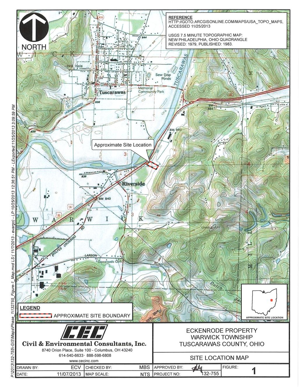
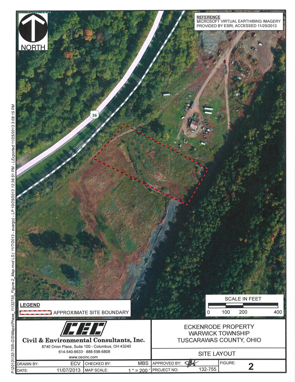
11 2.0 SUBJECT PROPERTY DESCRIPTION 2.1 LOCATION AND LEGAL DESCRIPTION The Subject Property is located southwest of the City of Urichsville in Warwick Township, Tuscarawas County, Ohio. The Subject Property is located east of U.S. Route 36 and consists of 3.3 acres of vacant land. The Subject Property is an approximately 300-foot easement within parcel number and the owner is listed as Thomas J. Eckenrode. A Site Location Map and Site Plan are attached as Figures 1 and 2, respectively. Ownership information obtained from the Tuscarawas County Auditor s website is provided in Appendix A. 2.2 SUBJECT PROPERTY AND VICINITY GENERAL CHARACTERISTICS The Subject Property is located about three miles southwest of the City of Urichsville in an area with a long history of industrial activity. The Subject Property is currently vacant with the exception of an active oil and gas well (well number 21285) located near the southeastern corner. Former use of the Subject Property was as a fill area for clay mine gob and broken vitrified clay tile as a waste product from the former kilns located north of the Subject Property. The Subject Property is bordered by a vacant, former wood pallet manufacturing facility to the north; vacant forested, former strip mine and clay mine land to the east; vacant land to the south; and railroad tracks, followed by U.S. Route 36 and the Tuscarawas River to the west. According to the New Philadelphia, Ohio USGS topographic map (Figure 1), ground surface in the immediate Subject Property vicinity is generally flat with rolling hills a few hundred feet to the east. The Subject Property is situated in a buried valley for the Tuscarawas River. The river trends northeast to southwest immediately west and parallel to US Route 36. In the vicinity of the Subject Property, the buried valley is approximately one mile wide with land surface near the Subject Property approximately 850 feet above mean sea level (msl). The valley walls rise to an elevation of approximately 1,050 feet msl less than 2000 feet to the east of the Subject Property. Overall relief on the Subject Property is less than 10 feet, but in the immediate surrounding area, relief is on the order of 200 feet, ranging in elevation from approximately 850 to 1,050 feet msl. 2.3 CURRENT USE OF THE SUBJECT PROPERTY The Subject Property is currently vacant except for the oil well. The balance of the Subject is open land, with drainage swales on the northern, eastern and western property boundaries. An Acre Eckenrode Property/CEC Project November 25, 2013
12 open excavation is present near the southern property boundary. The sidewalls of the open excavation indicated that surficial fill material consisting of a mix of cinders, broken clay sewer tile, coal, sand and gravel has been placed on the property. 2.4 DESCRIPTION OF STRUCTURES, ROADS, AND OTHER IMPROVEMENTS The Subject Property is accessible from an unpaved roadway along the east side, which enters from the adjacent property to the north. The unpaved roadway is accessed from U.S. Route 36 in roughly the center of adjacent property to the north. There are no structures on the Subject Property, and it is currently vacant with the exception of an active oil and gas well (well number 21285) located on the southeastern portion of the Subject Property. Appurtenances for the well consist of two storage tanks. The well appears to be properly maintained and no significant staining or spillage was observed in association with the well. Refer to Figure 2 for an aerial photograph showing the Subject Property and Appendix B for photographs showing the current configuration of the Subject Property. 2.5 CURRENT USES OF THE ADJOINING PROPERTIES The Subject Property is bordered by a vacant, former wood pallet manufacturing facility to the north; vacant, forested, reclaimed mine land to the east; vacant land to the south; and railroad tracks, followed by U.S. Route 36 and the Tuscarawas River to the west Acre Eckenrode Property/CEC Project November 25, 2013
13 3.0 USER PROVIDED INFORMATION Mr. Steve Mobley, of Ohioland, completed a user questionnaire and provided the following information indicating the extent of knowledge pertaining to the Subject Property. A copy of the completed user questionnaire is provided in Appendix C. The following sections summarize the information provided. 3.1 TITLE RECORDS CEC was not provided with any information with respect to title records, nor was CEC engaged to perform a title search for the Subject Property. 3.2 ENVIRONMENTAL LIENS OR ACTIVITY AND USE LIMITATIONS Mr. Mobley is not aware of any environmental liens or Activity and Use Limitations (AULs) against the Subject Property that have been filed or recorded under federal, tribal, state, or local law. 3.3 SPECIALIZED KNOWLEDGE Mr. Mobley stated that he does not have any specialized knowledge or experience related to the Subject Property or nearby properties. 3.4 COMMONLY KNOWN OR REASONABLY ASCERTAINABLE INFORMATION Mr. Mobley does not have specialized knowledge or experience related to the Subject Property or nearby properties. A previous Phase I ESA report was prepared by CEC for Preferred Fluids Management on November 23, 2011 for the adjacent property to the north of the Subject Property. Further discussion regarding this report is provided in Section EVALUATION REDUCTION FOR ENVIRONMENTAL ISSUES Mr. Mobley indicated that the purchase price for the Subject Property reasonably reflects its fair market value with no discount for environmental issues Acre Eckenrode Property/CEC Project November 25, 2013
14 3.6 OWNER, PROPERTY MANAGER, AND OCCUPANT INFORMATION Thomas J. Eckenrode is the current owner of the Subject Property. 3.7 REASON FOR PERFORMING PHASE I ESA CEC was engaged by Ohioland to perform this Phase I ESA as part of their due diligence prior to the potential purchase of the Subject Property and to satisfy one of the requirements to qualify for one of the landowner liability protections under CERCLA. 3.8 INTENDED USE OF THE SUBJECT PROPERTY According to Mr. Mobley, the Subject Property will be used to store aggregate material for the oil and gas extraction industry. 3.9 PROCEEDINGS INVOLVING THE SUBJECT PROPERTY Mr. Mobley is not aware of any pending, threatened, or past litigation relevant to hazardous substances or petroleum products in, on, or from the Subject Property; any pending, threatened, or past administrative proceedings relevant to hazardous substances or petroleum products in, on, or from the Subject Property; or any notices from any governmental entity regarding any possible violation of environmental laws or possible liability relating to hazardous substances or petroleum products Acre Eckenrode Property/CEC Project November 25, 2013
15 4.0 RECORDS REVIEW 4.1 ENVIRONMENTAL RECORD SOURCES Government Environmental Databases CEC contracted Environmental Data Resources, Inc. (EDR) of Milford, Connecticut to conduct a search of reasonably ascertainable environmental record sources published by Federal, State, and/or Tribal regulatory agencies with jurisdiction over the Subject Property. EDR also searches their proprietary databases of historical auto station, dry cleaner, and manufactured gas plant locations. The search of each database was conducted using the approximate minimum search distances from the Subject Property defined by the Standard. The results of EDR s search were used to evaluate if the Subject Property and/or properties within prescribed search distances are listed as having a past or present record of actual or potential environmental impact. Inclusion of a property in a government database list does not necessarily indicate that the property has an environmental problem. EDR plotted the locations of the listed properties identified in the search relative to the Subject Property and provided the regulatory information available for each in a Radius Map Report dated November 4, Refer to Appendix D for a copy of EDR s Radius Map Report, which includes an Overview Map and a Detail Map showing the locations of the identified properties Subject Property Listings The Subject Property was not listed on the databases included in the EDR Radius Map Report Non-Subject Property Listings EDR s Radius Map Report did not identify non-subject Property listings on the various databases within the approximate minimum search distances from the Subject Property Please refer to EDR s Radius Map Report in Appendix D Acre Eckenrode Property/CEC Project November 25, 2013
16 Orphan Listings Not all sites or facilities identified in the database records can be accurately located in relation to the Subject Property due to incomplete information being supplied to the regulatory agencies and are referred to as orphan sites by EDR. The Orphan Summary section of the EDR Radius Map Report identified several orphan sites. Based on a drive-by reconnaissance of the Subject Property vicinity and review of location and status information provided in the database report, none of the identified orphan sites are located within the search radii for databases specified by the Standard Local Fire Department CEC submitted a written request, dated November 5, 2013, to the Urichsville Fire Department for records of any current or former petroleum UST(s) and/or ASTs, fires, or other potential environmental concerns on the Site. As of the date of this report, CEC has not received a response; however, if information becomes available that alters the conclusions of this report, CEC will notify Ohioland and issue an addendum to this report. A copy of CEC s request letter to the fire department is included in Appendix E Local Health Department CEC submitted a written request, dated November 5, 2013 to the Tuscarawas County Health Department for information about potential environmental concerns on the Subject Property. As of the date of this report, CEC has not received a response; however, if information becomes available that alters the conclusions of this report, CEC will notify Ohioland and issue an addendum to this report. A copy of CEC s request letter to the health department is included in Appendix E State Environmental Regulatory Agency Review Based on information obtained from the Subject Property Site Reconnaissance, interviews, and review of the regulatory database report, a regulatory agency file review was not warranted for the purpose of this report Acre Eckenrode Property/CEC Project November 25, 2013
17 4.2 PHYSICAL SETTING SOURCES CEC reviewed mapping information to evaluate the general characteristics of the subsurface geology in the vicinity of the Subject Property. This information was reviewed to evaluate how those characteristics may influence movement of potential subsurface impacts identified on or near the Subject Property. It was not the intent of this review to evaluate the geotechnical conditions of the Subject Property or to assess geologic concerns such as foundation conditions, faulting, subsidence, mining, or oil/gas wells Topography The New Philadelphia, Ohio 7.5-minute topographic quadrangle published by USGS in 1983 was reviewed to evaluate Subject Property topography and surface drainage patterns in the Site vicinity. Ground surface in the Subject Property vicinity is generally flat with a slight downward slope toward the Tuscarawas River, which is located immediately across US Route 36 to the west. The map indicates that the surface elevation of the Subject Property is approximately 850 feet above mean sea level (msl). Overall relief on the Subject Property is less than 10 feet; however, the walls of the Tuscarawas River valley rise about 150 feet above the level of the valley floor within a few hundred feet east of the Site. 4.3 HISTORICAL USE INFORMATION ON THE SUBJECT PROPERTY AND ADJOINING PROPERTIES CEC reviewed the readily available historical sources described in the following sections to ascertain the historical uses of the Subject Property and immediately adjacent properties to evaluate the presence of activity that could present RECs. Information, as summarized below, was obtained dating back to Ownership Records Ownership information for the Subject Property was obtained from the Tuscarawas County Auditor s office. The records show the Subject Property is currently owned by Thomas J. Eckenrode as recorded on Deed Book 1205, Page 1147 on October 24, Acre Eckenrode Property/CEC Project November 25, 2013
18 4.3.2 Aerial Photographs Aerial photographs were obtained for the vicinity of the Subject Property from EDR. Photographs were available from 1960, 1971, 1976, 1991, 1994, 2000, 2005, 2006, 2009, 2010, and The scale, resolution, and/or quality of some of the aerial photographs limited our ability to discern specific Subject Property and vicinity features relative to historical uses. The 1960 aerial photograph showed the Subject Property as vacant. Agricultural land was apparent to the northwest across the Tuscarawas River. The former strip mine was apparent on the property immediately east. Vacant or agricultural land was apparent to the south, with a few residential properties located to the south and southwest of the Subject Property. The 1971 and 1976 aerial photographs continued to show the Subject Property as vacant. A building and kilns associated with a pottery operation were located on the property to the north and land grading was apparent on property to the east of the Subject Property. These two photographs showed apparent grading and filling on the Subject Property. The 1991 and 1994 aerial photographs depicted the Subject Property as vacant. A structure associated with an access road was located on the property directly north of the Subject Property. Trails and roadways indicative of mine reclamation were located on the properties to the east of the Subject Property. The kilns on the property to the north of the Subject Property appeared to no longer be present in the 1994 aerial photograph. The 2000 through 2006 aerial photographs showed little change associated with the Subject Property and adjacent properties with the exception of a decrease in land disturbance activities associated with the mine reclamation operations to the east of the Subject Property. The 2009 through 2011 aerial photographs showed a decrease in vegetation located on the Subject Property. Trailers appeared to be located on the property to the north of the Subject Property. Rust colored soil (often indicative of acid mine drainage) was also visible on the property to the north and within a ditch directly north and adjacent to the Subject Property. Copies of the aerial photographs are included in Appendix F Acre Eckenrode Property/CEC Project November 25, 2013
19 4.3.3 Fire Insurance Maps CEC engaged EDR to search their library for Sanborn Fire Insurance Company Maps (Sanborn maps) available for the Subject Property. According to EDR, Sanborn map coverage was not available for the Subject Property. A copy of the Unmapped Property letter is attached as Appendix G Previous Reports A previous Phase I ESA report was prepared by CEC for Preferred Fluids Management on November 23, 2011 for the property to the north of the Subject Property. This report revealed the following RECs associated with the property to the north of the Subject Property: The scrap consisting of old cars, trucks, semi tractor-trailers, motor homes, boats, other vehicles, 55-gallon drums, tires, and batteries should be removed from the Site and managed or disposed in accordance with applicable regulations. The property to the northeast was being used as a salvage yard for large machinery, scrap metal, and equipment. There were a number of scrap drums and scrap tanks at the southern end of the adjacent property, immediately across from the northeast corner of the Site. The drums and tanks appeared to be empty at the time of the site visit, but the condition and content of the tanks at the time they were placed on the adjacent property could not be determined; therefore, the scrap tanks and drums are a REC in connection with the Site. The sidewalls of the open excavation near the southern property boundary indicated that fill material has been placed across the Site. The fill material consists of a mix of cinders, broken clay sewer tile, coal, sand and gravel. The fill material is considered a REC in connection with the Site. The topographic mapping included in that Phase I ESA report were from 1911, 1962, 1971, 1985, 1993, and 1994 and showed clay mining operations located on the property to the east of the Subject Property, specifically in the 1962 through 1985 maps and a structure, presumed to be a pottery operation with associated kilns was located on the northern property in the 1962 through 1985 maps. A small area of strip mining was also located on the land directly east of the Subject Property in these maps. The Subject Property appeared vacant in the topographic maps Acre Eckenrode Property/CEC Project November 25, 2013
20 Please refer to Appendix C for a copy of this Phase I ESA. 4.4 HISTORICAL USE SUMMARY Summary of the Historical Use of the Subject Property The records show the Subject Property has remained vacant since at least Summary of the Historical Use of the Adjacent Properties The majority of the adjacent properties to the north, south and west of the Subject Property was formerly agricultural land until clay mining operations began to the east of the Subject Property from prior to 1962 until at least A pottery operation with associated kilns was located on property further north from approximately the 1960s until the 1980s Acre Eckenrode Property/CEC Project November 25, 2013
21 5.0 SUBJECT PROPERTY RECONNAISSANCE 5.1 METHODOLOGY AND LIMITING CONDITIONS On November 5, 2013, Andrew McCorkle, an EP with CEC performed a reconnaissance to visually and physically observe the Subject Property and the immediate vicinity for potential evidence and/or practices that could represent RECs. At the time of the reconnaissance, the visibility at the Subject Property was good and weather conditions did not interfere with the observations. The following methodology was used when performing the reconnaissance: Observed the exterior portions of the Subject Property by traversing the grounds in a random pattern and traveling the perimeter. Observed land use and types of operations of the immediate adjacent properties from the Subject Property and public areas. A Site Location Map and Site Plan Map are attached as Figures No. 1 and 2, respectively. Photographs taken during the site reconnaissance are attached as Appendix B. 5.2 GENERAL SUBJECT PROPERTY SETTING The Subject Property currently consists of generally flat ground that is vacant except for an oil well. Properties in the Subject Property vicinity are a mix of light industrial uses, former manufacturing, and former mine land. The Subject Property is bordered to the west by railroad tracks and US Route 36 and to the north by vacant land followed by a former pallet manufacturing facility. To the northeast is a salvage yard/heavy equipment repair operation. To the east, the Subject Property is bordered by reclaimed coal and clay mining land. The property to the south is a large open field followed by residential properties. Ground surface in the immediate Subject Property vicinity is generally flat with rolling hills a few hundred feet to the east. The Site is situated in a buried valley for the Tuscarawas River. The river trends northeast to southwest immediately west and parallel to US Route Acre Eckenrode Property/CEC Project November 25, 2013
22 5.3 SUBJECT PROPERTY WIDE OBSERVATIONS The following conditions were specifically assessed for their potential to indicate RECs and may include conditions inside or outside structures on the Subject Property Hazardous Substances and Petroleum Products CEC did not observe operations that use, treat, store, dispose of, or generate hazardous materials or petroleum products on the Subject Property Storage Tanks Underground Storage Tanks (USTs) No obvious visual evidence indicating the current presence of USTs (i.e. vent pipes, fill ports, etc.) was noted Aboveground Storage Tanks (ASTs) Two above-ground poly tanks were associated with the oil well. No obvious visual evidence indicating the historical presence of ASTs (i.e. secondary containments, concrete saddles, etc.) was observed Odors No obvious strong, pungent, or noxious odors were noted during the reconnaissance Pools of Liquid Except for a small amount of standing water in an excavation on the Subject Property, pools of liquid were not observed during the reconnaissance Drums and Containers CEC did not observe storage containers greater than 1-gallon in size on the Subject Property, except for those associated with oil well Acre Eckenrode Property/CEC Project November 25, 2013
23 5.3.6 Unidentified Substance Containers CEC did not observe open or damaged containers containing unidentified substances at the Subject Property Suspect Polychlorinated Biphenyl (PCB) Containing Equipment The Subject Property and immediate vicinity were viewed for the presence of potential PCBcontaining equipment, such as electrical transformers, capacitors, and hydraulic equipment Transformers No transformers were observed during the site reconnaissance Other Potential PCB-Containing Equipment CEC did not observe other major classes of equipment suspected of containing PCBs on the Subject Property. 5.4 INTERIOR OBSERVATIONS The Subject Property is currently vacant with no structures. 5.5 EXTERIOR OBSERVATIONS The following exterior conditions at the Subject Property were specifically assessed for their potential to indicate RECs Pits, Ponds, Lagoons, and Surface Waters A small creek is situated along the eastern property boundary that drains westward along or near the northern property boundary. Another drainage feature is present along the western side of the Subject Property that drains water from the properties to the north. This drainage feature appears to be on adjacent property to the west. The purpose for the drainage feature is reported by the current owner to act as a cistern, or a retention pond for infiltration of storm water from the former clay manufacturing facility to the north of the Subject Property. This feature was previously identified in Acre Eckenrode Property/CEC Project November 25, 2013
24 other reports as a REC because there was no documentation of materials that might have runoff from the clay tile manufacturer. This feature is not considered a REC because it is not located on the Subject Property. There was also iron staining in the bed of the creek on the northern and eastern sides of the Subject Property. This iron staining may indicate drainage from the reclaimed coal and clay mines east of the Subject Property Stained Surfaces and Distressed Vegetation There was red/iron staining in the creek and drainage swale near the eastern, northern, and western property boundaries. No stressed vegetation was observed Solid Waste No dumpsters or other solid waste containers were observed on the Subject Property. Except for the broken clay tile and mine gob fill placement across the property, CEC did not observe areas of open dumping of trash or construction or demolition debris on the Subject Property Waste Water No obvious indications of a wastewater system were observed on the Subject Property. Municipal sewer service is not provided to the Subject Property Storm Water As discussed above, a small creek is situated along the eastern property boundary that drains westward along or near the northern property boundary. Another drainage feature is present along the western side of the Subject Property that drains water from the properties to the north. Storm water sheet flows to these drainage channels. 5.6 ADJACENT PROPERTY OBSERVATIONS To the extent that they were visibly and/or physically observable, CEC viewed each adjacent property from the Subject Property and adjacent public areas to evaluate the apparent land use Acre Eckenrode Property/CEC Project November 25, 2013
25 for the potential to indicate RECs in connection with the Subject Property. CEC s observations are summarized as follows: North: The Subject Property is bounded to the north vacant property that is being developed for oilfield services. East: The Subject Property is bounded to the east by former clay and coal mining land. There was iron staining observed in the creek along the eastern property boundary that may be a result of drainage from the former mining operations. South: The Subject Property is bounded to the south by a large vacant open field. West: The Subject Property is bounded to the west by railroad tracks followed by US Route 36. A Site Location Map and Site Plan Map are attached as Figures 1 and 2, respectively. Photographs taken during the site reconnaissance are attached as Appendix B Acre Eckenrode Property/CEC Project November 25, 2013
26 6.0 INTERVIEWS CEC interviewed various individuals familiar with the Subject Property, as identified to us, and/or government officials in order to evaluate historical uses and identify potential RECs. The individuals interviewed were asked to provide responses in good faith and to the best of their knowledge. The following sections identify the individuals interviewed and summarize the information each provided; however, additional information provided by these individuals may be presented in other sections of this report. 6.1 CURRENT OWNER Mr. Tom Eckenrode, current owner of the Subject Property, was interviewed during the Site reconnaissance on November 5, 2013 as a representative of the owner, occupant and manager. Mr. Eckenrode has owned the Subject Property since 1992, and performs many maintenance activities for the properties in this area. Information from the interview with Mr. Eckenrode is summarized as follows: Mr. Eckenrode has been associated with the property since 1992, at which time he purchased adjacent properties to the northeast. Mr. Eckenrode indicated that he had no knowledge of on-site USTs. Mr. Eckenrode indicated that the Subject Property was formerly used by Universal Sewer Pipe Corporation as a fill area for scrap and broken clay sewer tile, slag, and cinders, and by the former strip mine as a fill area for waste coal from the former operations. Some of the remnants from the sewer pipe operation are still present including scattered clay tile sewer pipe across the entire property. Mr. Eckenrode indicated that clay and coal mining operations were performed on the property further to the east. Mr. Eckenrode indicated that he had water in the creek along the eastern property boundary tested for ph in order to evaluate the potential for acid mine drainage. According to Mr. Eckenrode, the ph of the water was within an acceptable range Acre Eckenrode Property/CEC Project November 25, 2013
27 Mr. Eckenrode indicated that he had no knowledge of on site production, storage, or disposal of hazardous materials and/or petroleum products in connection with the Subject Property other than the obvious oil production well. Mr. Eckenrode indicated that he was unaware of any pending, threatened, or past litigation related to the Subject Property. Mr. Eckenrode indicated that he was unaware of any administrative proceedings associated with the Subject Property. Mr. Eckenrode indicated that he was unaware of any notices from governmental entities regarding possible violation of environmental laws, environmental liens, or possible liability relating to hazardous substances or petroleum products. 6.2 CURRENT MANAGER See Section CURRENT OCCUPANTS See Section OTHER INTERVIEWS No other parties were interviewed as part of this Phase I ESA Acre Eckenrode Property/CEC Project November 25, 2013
28 7.0 EVALUATION 7.1 FINDINGS Based upon the information gathered as part of this Phase I ESA, the following is a summary of CEC s findings: The Subject Property consists of 3.3 acres located east of U.S. Route 36, less than 3 miles southwest of the City of Urichsville. The Subject Property is currently vacant with the exception of an active oil and gas well (well number 21285) located on the southeastern portion of the Subject Property. The well appears to be properly maintained and no significant staining or spillage was observed in association with the well. The Subject Property is bordered by a vacant, former wood pallet manufacturing facility to the north; vacant forested, reclaimed mine land to the east; vacant land to the south; and railroad tracks, followed by U.S. Route 36 and the Tuscarawas River to the west. The records show no structures constructed on the Subject Property since at least The majority of the adjacent property to the north, south and west of the Subject Property was formerly agricultural land until clay mining operations began to the east of the Subject Property from at least the 1960s until the 1990s. A pottery operation with associated kilns was located on the northern property from approximately the 1960s until the 1980s. A previous Phase I ESA report prepared by CEC for Preferred Fluids Management on November 23, 2011 for the property to the north of the Subject Property revealed RECs associated with the adjacent property including: o The sidewalls of the open excavation in the south central portion of the property indicated that as much as eight feet of fill material had been placed across the property. The fill material consisted of a mix of cinders, broken clay sewer tile, coal, sand and gravel. The fill material was considered a REC. Clay and coal strip mining operations were located on the property to the east of the Subject Property from prior to 1962 through at least 1985 and a pottery operation with Acre Eckenrode Property/CEC Project November 25, 2013
29 associated kilns was located on property further north during the same time frame. The coal strip mining appeared to be located on the land directly east of the Subject Property. 7.2 OPINIONS Based on the findings of this ESA, CEC offers the following opinions relative to environmental impact on the Subject Property by the conditions identified. The placement of fill material on the Subject Property is considered a REC because of the potential for metals to be associated with former coal mining and/or clay mining operations. The fill material constitutes a REC with low to moderate potential for environmental impact. 7.3 SIGNIFICANT DATA GAPS During the course of this ESA, CEC did not identify significant data gaps in the information collected that would affect our ability to provide an opinion as to whether the ESA has identified conditions that could represent a REC to the Subject Property. 7.4 CONCLUSIONS CEC has performed a Phase I ESA in conformance with the scope and limitations of ASTM Practice E for the Subject Property. Any exception to, or deletions from, this practice are described in Sections 1.4 and 8.0 of this report. The ESA has revealed no RECs in connection with the Subject Property except for the following: The sidewalls of the open excavation in the south central portion of the property indicated that as much as eight feet of fill material had been placed across the property. The fill material consisted of a mix of cinders, broken clay sewer tile, coal, sand and gravel Acre Eckenrode Property/CEC Project November 25, 2013
30 8.0 DEVIATIONS CEC has performed this Phase I ESA in general conformance with the scope and limitations of the Standard with no identified deletions and no additions, except as described in Section Acre Eckenrode Property/CEC Project November 25, 2013
31 9.0 ADDITIONAL SERVICES Ohioland did not request the performance of additional services as part of this Phase I ESA.: Acre Eckenrode Property/CEC Project November 25, 2013
32 10.0 REFERENCES Standard Practice for Environmental Site Assessments: Phase I Environmental Site Assessment Process; ASTM; 2005 CEC s Proposal for Phase I Environmental Site Assessment: November 5, New Philadelphia, Ohio 7.5 Minute Topographic Quadrangle Map: United States Geological Survey, The EDR Radius Map Report: Inquiry Number r, Environmental Data Resources, Inc.; November 04, The EDR Certified Sanborn Map Report: Environmental Inquiry Number , Environmental Data Resources, Inc.; November 04, Sanborn Fire Insurance Maps were unavailable. Phase I Environmental Assessment Report: Prepared by Civil & Environmental Consultants. Inc. for Preferred Fluids Management, Inc. November Acre Eckenrode Property/CEC Project November 25, 2013
33 11.0 QUALIFICATIONS AND SIGNATURES OF ENVIRONMENTAL PROFESSIONALS This report was prepared by Andrew McCorkle and reviewed by Ronald Wells, both EPs with CEC. Their qualifications are attached as Appendix H. We declare that, to the best of our professional knowledge and belief, we meet the definition of Environmental Professional as defined in 40 CFR and we have the specific qualifications based on the education, training, and experience to assess a property of the nature, history, and setting of the Subject Property. We have developed and performed the all appropriate inquiries in conformance with the standards and practices set forth in 40 CFR Part 312. Prepared by: Reviewed by: Andrew G. McCorkle Principal Ronald J. Wells Project Manager Acre Eckenrode Property/CEC Project November 25, 2013
34 FIGURES
35
36
37 APPENDIX A PROPERTY AND WELL OWNER RECORDS
38
39
40
41
42
43 APPENDIX B PHOTOGRAPHS


44 Photograph 1: View to the west along the southern property boundary Photograph 2: View to the west in the central portion of the Subject Property Civil & Environmental Consultants, Inc. Columbus, OH ACRE PARCEL ECKENRODE PROPERTY UHRICHSVILLE, OHIO Photographs Taken On November 5, 2013


45 Photograph 3: Sidewall of excavation in the central portion of the Subject Property. Note broken clay sewer tile Photograph 4: View into excavation in the central portion of the Subject Property. Note small amount of standing water in the far end of the excavation Civil & Environmental Consultants, Inc. Columbus, OH ACRE PARCEL ECKENRODE PROPERTY UHRICHSVILLE, OHIO Photographs Taken On November 5, 2013


46 Photograph 5: Southwest property corner Photograph 6: View to the northeast from the southwest property corner Civil & Environmental Consultants, Inc. Columbus, OH O 3.3-ACRE PARCEL ECKENRODE PROPERTY UHRICHSVILLE, OHIO Photographs Taken On November 5, 2013


47 Photograph 7: Northwest property corner Photograph 8: View to the southeast from the northwest property corner Civil & Environmental Consultants, Inc. Columbus, OH ACRE PARCEL ECKENRODE PROPERTY UHRICHSVILLE, OHIO Photographs Taken On November 5, 2013


48 Photograph 9: Drainage swale along the northern property line Photograph 10: View to the east along the north property line and drainage swale Civil & Environmental Consultants, Inc. Columbus, OH ACRE PARCEL ECKENRODE PROPERTY UHRICHSVILLE, OHIO Photographs Taken On November 5, 2013


49 Photograph 11: Rubble pile in the central portion of the Subject Property Photograph 12: Clearing in the central portion of the Subject Property. Note broken clay sewer tile Civil & Environmental Consultants, Inc. Columbus, OH ACRE PARCEL ECKENRODE PROPERTY UHRICHSVILLE, OHIO Photographs Taken On November 5, 2013


50 Photograph 13: View to the west along the northern property line Photograph 14: Gray soil/rock near the oil well Civil & Environmental Consultants, Inc. Columbus, OH ACRE PARCEL ECKENRODE PROPERTY UHRICHSVILLE, OHIO Photographs Taken On November 5, 2013


51 Photograph 15: Oil well information Photograph 16: Oil inside holding tank Civil & Environmental Consultants, Inc. Columbus, OH ACRE PARCEL ECKENRODE PROPERTY UHRICHSVILLE, OHIO Photographs Taken On November 5, 2013


52 Photograph 17: Oil inside holding tank Photograph 18: Overview of the oil well Civil & Environmental Consultants, Inc. Columbus, OH ACRE PARCEL ECKENRODE PROPERTY UHRICHSVILLE, OHIO Photographs Taken On November 5, 2013
 Civil & Environmental")

53 Photograph 19: Oil well information Photograph 20: Northeastern property corner (rusted steel pipe) Civil & Environmental Consultants, Inc. Columbus, OH ACRE PARCEL ECKENRODE PROPERTY UHRICHSVILLE, OHIO Photographs Taken On November 5, 2013


54 Photograph 21: View to the southwest from the northeastern property corner Photograph 22: View to the south from the northeastern property corner Civil & Environmental Consultants, Inc. Columbus, OH ACRE PARCEL ECKENRODE PROPERTY UHRICHSVILLE, OHIO Photographs Taken On November 5, 2013
55 APPENDIX C USER PROVIDED INFORMATION
56
57
58
59
60
61
62
63
64

65 Phase I Environmental Site Assessment Report Mahaffey Property 6505 (Rear) US Route 36 SE Uhrichsville, Tuscarawas County, Ohio Prepared for: Preferred Fluids Management CEC Project November 2011
66 November 23, 2011 Mr. Steve Mobley Preferred Fluids Management 2205 Westover Road Austin, Texas Dear Mr. Mobley: Subject: Phase I Environmental Site Assessment Mahaffey Property 6505 (Rear) US Route 36 SE Uhrichsville, Ohio CEC Project Civil & Environmental Consultants, Inc. (CEC) presents for your use the enclosed Phase I Environmental Assessment (ESA) of the approximately 5-acre Mahaffey property located at 6505 (Rear) US Route 36 SE in Uhrichsville, Ohio. This assessment was performed as outlined in CEC s Proposal No , dated November 7, CEC appreciates the opportunity to provide environmental services to Preferred Fluids Management and we look forward to continuing to assist on this and other future projects. Please contact us if you have any questions or comments. Sincerely, CIVIL & ENVIRONMENTAL CONSULTANTS, INC. Andrew G. McCorkle, CPG Principal Enclosures Civil & Environmental Consultants, Inc. Columbus 8740 Orion Place, Suite 100 Pittsburgh 800/ Export 800/ Orion Office Park Chicago 887/ Indianapolis 877/ Columbus, Ohio Cincinnati 800/ Nashville 800/ Phone 614/ Cleveland 866/ Phoenix 877/ Fax 614/ Detroit 866/ St. Louis 866/ Toll Free 888/ columbus@cecinc.com Corporate Web Site
67 TABLE OF CONTENTS Page Executive Summary... iv 1.0 Introduction Purpose Scope of Services Historic Review Government Agency Review Site Reconnaissance Interviews Report of Findings Significant Assumptions Limitations And Exceptions Special Terms And Conditions User Reliance Site Description Site Location and Legal Description Site And Vicinity General Characteristics Current Use Of The Site Descriptions Of Structures, Roads, And Other Improvements Current Uses Of The Adjoining Properties User Provided Information Title Records Environmental Liens Or Activity And Use Limitations Specialized Knowledge Valuation Reduction For Environmental Issues Owner, Property Manager, And Occupant Information Reason For Performing A Phase I Records Review Standard Environmental Record Sources Site Listings Off-Site Listings Orphan Sites Additional Environmental Record Sources Health Department Fire Department Physical Setting Sources Topographic Map Historical Use Information Historic Sanborn Fire Insurance Company Map Review Historic USGS Topographic Map Aerial Photograph Review Historical Review Summary...10
68 Table of Contents (continued) Page ii 6.0 Site Reconnaissance Methodology And Limiting Conditions General Site Setting Site Wide Observations Underground Storage Tanks Aboveground Storage Tanks Odors Pools of Liquid Drums and Containers Unidentified Substance Containers PCBs Pits, Ponds, Lagoons and Surface Waters Stained Soil or Pavement Stressed Vegetation Solid Waste Wastewater System Potable Water Supply and Wells Septic Systems Heating and Cooling Stains or Corrosion Drains and Sumps Adjacent Properties Interviews Interview With Owner Representive Interview With Site Manager Interview With Local Government Officials Interview With Others Additional Services Findings Opinions Opinions On Recognized Environmental Conditions Data Gaps Conclusions Deviations References Signatures of Environmental Professionals Qualifications of Environmental Professionals...27
69 Table of Contents (continued) Page iii LIST OF FIGURES Figure Site Location...1 Site Layout...2 LIST OF APPENDICES Appendix User Questionnaire... A EDR Database Report... B EDR Sanborn Search Report... C Historical Topographic Maps... D Aerial Photographs... E City Directory Abstract... F Site Reconnaissance Photographs... G Qualifications of Principal Investigator and Reviewer... H
70 EXECUTIVE SUMMARY Civil & Environmental Consultants, Inc. (CEC) conducted a Phase I Environmental Site Assessment (ESA) of an approximately 5-acre parcel of land located at 6505 (Rear) US Route 36 SE in Uhrichsville, Ohio (the Site). The Phase I ESA was completed in general conformance with the scope and limitations set forth in ASTM Designation E Standard Practice for Environmental Site Assessments: Phase I Environmental Site Assessment Process, published by American Society for Testing and Materials (ASTM) in 2005 and CEC proposal dated November 7, This executive summary is provided for convenience and should not substitute for review of the complete report, including all attachments. A brief summary of findings and conclusions is provided below. The Site consists of approximately 5 acres of land located at the south end of property identified as 6505 US Route 36 SE, Uhrichsville, Tuscarawas County, Ohio (the Site), which is on the east side of Route 36, about three miles west of the town of Uhrichsville. The Site is accessible via an access drive that enters in roughly the midsection of the property from the adjacent property to the north. The Site consists of generally flat ground and is occupied by a maintenance shed that is used for semi truck maintenance. Properties in the Site vicinity are a mix of light industrial uses, former manufacturing, and former mine land. The Site is bordered to the west by railroad tracks and US Route 36, and to the north by A1 Wood Products, a pallet manufacturing company. To the northeast, the Site is bordered by a salvage yard/heavy equipment repair operation, and to the east by reclaimed coal and clay mining land. The property to the south is an open field. The Site currently is occupied by a small truck maintenance facility and is developed with an approximately 1,500 square foot, metal pole-barn type maintenance building. Associated pieces of scrap are present on the property surrounding the maintenance building. The scrap consists of old cars, trucks, semi tractor-trailers, motor homes, boats, a golf cart, a forklift, a dump truck, 55-gallon drums, tires, used pallets, and batteries. The balance of the property is open land, with drainage swales on the eastern and western property boundaries. An open excavation is present near the southern property boundary. The sidewalls of the open excavation indicated that surficial fill material consisting of a mix of cinders, broken clay sewer tile, coal, sand and gravel has been placed on the property. The Site is not listed on environmental databases specified in the Standard. There were numerous empty 55-gallon drums and large scrap storage tanks on the adjacent property at the southeast corner of the Site. Many of the drums were not labeled, but labels observed on some of the drums indicated that the drums contained automatic transmission R iv - November 2011
71 fluid. No obvious staining or spillage was observed in the vicinity of the drums. The condition of the tanks and drums at the time they were placed on the property could not be determined. There was one oil well situated on the southeastern portion of the Site. Minor staining and oil-like odors were associated with the well. The staining and minor odors represent a de minimis condition and are not considered a REC. Several 55-gallon drums were observed at various locations around the site and surrounding properties. Most of the drums were empty, rusted and in various states of having been crushed or rusted through. At least three of the drums located near the maintenance building were full or partially full; however, the drums were not labeled and the contents could not be verified. No obvious staining or spillage was observed near the drums; but because the condition of the tanks and drums at the time they were placed on the property could not be determined, the scrap tanks and drums are considered a REC in connection with the Site. This assessment has revealed no evidence of recognized environmental conditions (as defined in the ASTM standard) on the Site except for the following: The scrap consisting of old cars, trucks, semi tractor-trailers, motor homes, boats, other vehicles, 55-gallon drums, tires, and batteries should be removed from the Site and managed or disposed in accordance with applicable regulations. The property to the northeast was being used as a salvage yard for large machinery, scrap metal, and equipment. There were a number of scrap drums and scrap tanks at the southern end of the adjacent property, immediately across from the northeast corner of the Site. The drums and tanks appeared to be empty at the time of the site visit, but the condition and content of the tanks at the time they were placed on the adjacent property could not be determined; therefore, the scrap tanks and drums are a REC in connection with the Site. The sidewalls of the open excavation near the southern property boundary indicated that fill material has been placed across the Site. The fill material consists of a mix of cinders, broken clay sewer tile, coal, sand and gravel. The fill material is considered a REC in connection with the Site. R v - November 2011
72 1.0 INTRODUCTION Preferred Fluids Management, Inc. engaged CEC to perform a Phase I ESA of an approximately 5-acre parcel of land located at 6505 (Rear) US Route 36 SE in Uhrichsville, Tuscarawas County, Ohio (the Site). The Site consists of Tuscarawas County Parcel No and includes one approximately 1,500 square-foot maintenance building for truck repair. The location of the Site with respect to roadways and principal surface features is depicted on Figures 1 and PURPOSE The purpose of this Phase I ESA is to identify, to the extent feasible pursuant to the process described herein, recognized environmental conditions (RECs) in connection with the Site in accordance with American Society for Testing and Materials (ASTM) Designation E , Standard Practice for Environmental Site Assessments: Phase I Environmental Site Assessment Process (the Standard ). The term recognized environmental conditions means the presence or likely presence of hazardous substances or petroleum products on a property under conditions that indicate an existing release, a past release, or a material threat of a release of hazardous substances or petroleum products into structures on the property or into the ground, groundwater, or surface water of the property. The term includes hazardous substances or petroleum products even under conditions in compliance with laws. The term is not intended to include de minimis conditions that generally do not present a threat to human health or the environment and that generally would not be the subject of an enforcement action if brought to the attention of appropriate government agencies. Conditions determined to be de minimis are not recognized environmental conditions. R November 2011
73 2.0 SCOPE OF SERVICES CEC performed the following scope of services to meet the objectives of the Phase I ESA. Unless otherwise explicitly stated, the scope of services for the Phase I ESA did not include the collection and analysis of any environmental media. In accordance with the Standard, issues considered beyond the scope of this Phase I ESA include asbestos-containing materials, radon, lead-based paint, lead in drinking water, wetlands, regulatory compliance, cultural and historic resources, industrial hygiene, health and safety, ecological resources, endangered species, indoor air quality, biological agents and mold. In addition, issues regarding ionizing radiation, oil/gas production, mineral rights and mining, and geotechnical suitability are also considered beyond the scope of this project. 2.1 HISTORIC REVIEW CEC reviewed historical information to assist in the evaluation of the previous uses of the property and surrounding area to attempt to identify the likelihood of past uses having led to RECs in connection with the Site. CEC reviewed historic resources describing the nature of former site use and items of potential environmental significance. The sources reviewed included Sanborn Fire Insurance Company (Sanborn) map records, U.S. Geological Survey (USGS) topographic maps, city directories, and aerial photographs. 2.2 GOVERNMENT AGENCY REVIEW A computer search of reasonably ascertainable and practically reviewable government environmental agency databases was performed to determine if the subject property or adjacent properties were listed on government databases indicative of potential environmental problems or notifications. The federal, state, and tribal records reviewed for the environmental profile included those listed in the Standard as available through a database search firm. Environmental Data Resources, Inc. (EDR) of Milford, Connecticut was the firm that conducted the database search for this ESA. 2.3 SITE RECONNAISSANCE A site reconnaissance was conducted by Mr. Andrew McCorkle, an Environmental Professional (EP) with CEC, on November 8, 2011 to visually evaluate the Site for indications of potential RECs in connection with the Site as described in the Standard. Portions of adjacent properties visible from the Site or publicly accessible areas (e.g., roads, rights-of-way, etc.) were also observed. R November 2011
74 2.4 INTERVIEWS Mr. Tom Eckenrode, owner of the facility adjacent to the northeast Site boundary, was interviewed during the Site reconnaissance on November 8, Mr. Eckenrode has owned and been working at the adjacent property since 1992 and is familiar with the Site and surrounding area. Mr. Eckenrode was also familiar with the history of the Site and its former use by the Universal Sewer Pipe Corporation. 2.5 REPORT OF FINDINGS After completion of the above tasks, CEC s EP prepared this Phase I ESA report describing the scope of services performed; the findings including identification of RECs or the lack thereof; opinions of the impact of the RECs (if any were identified) on the Site; and an opinion on the need for additional appropriate investigations. 2.6 SIGNIFICANT ASSUMPTIONS This assessment included a review of documents listed in Section 13.0 of this report. CEC has assumed these documents are accurate, unless stated otherwise. 2.7 LIMITATIONS AND EXCEPTIONS CEC performed this environmental assessment consistent with professional standards and in accordance with the scope and limitations defined in the Standard. This report presents CEC's field observations, results and opinions as they existed on the date of the site reconnaissance. This report is subject to modification by CEC, if CEC or any other party develops subsequent information. The scope of services focused on property history and the identification of environmental conditions associated with past and current property use. The reliability of information provided to CEC, including that provided by owners, occupants, subcontractors, and others, cannot be guaranteed. Performance of this environmental assessment is intended to reduce, but not eliminate, uncertainty of environmental conditions associated with the property. Therefore, the information and comments made in this report should not be construed to warrant or guarantee the property, or express or imply, without limitation, warranties as to its marketability or fitness for a particular use. Furthermore, the information that is provided in this report is not intended, nor should it be construed to be, legal advice. The review of site-specific documentation was limited to those items referenced in this report. There were no exceptions to the Standard during the preparation of this report unless otherwise noted. R November 2011
75 2.8 SPECIAL TERMS AND CONDITIONS This assessment was performed substantially as outlined in CEC s Proposal No , dated November 7, 2011, and is subject to the contractual terms referenced therein. 2.9 USER RELIANCE This report may be relied upon by Preferred Fluids Management, Inc. in accordance with the agreed upon terms and conditions. Reliance on this document by any other party is forbidden without the express written consent of CEC. Use of this report for purposes beyond those reasonably intended by Preferred Fluids Management, Inc. and CEC will be at the sole risk of the user. R November 2011
76 3.0 SITE DESCRIPTION 3.1 SITE LOCATION AND LEGAL DESCRIPTION The Site consists of approximately 5 acres of land located at 6505 US Route 36 SE, Uhrichsville, Tuscarawas County, Ohio (the Site), which is on the east side of Route 36, about three miles west of the town of Uhrichsville (Figure 1). The Site is further described as Tuscarawas County Parcel Number comprising acres, currently owned by Howard L. & Mary Mahaffey, recorded on Tuscarawas County deed book 1196, page 1989 on August 3, Deed and title records were not provided to CEC for this Phase I ESA. The approximate boundaries of the Site are indicated on Figure SITE AND VICINITY GENERAL CHARACTERISTICS The Site currently consists of generally flat ground with a small maintenance shed and associated scrap equipment in roughly the center of the property. The Site is situated east of US Route 36, and is east of railroad tracks that run parallel to Route 36. The Site is accessible via a gravel access drive that enters from the property to the north. The access drive crosses the railroad tracks approximately 1,000 feet north of the Site and then extends south to enter at the northern property boundary. Properties in the Site vicinity are a mix of light industrial uses, former manufacturing, and former mine land. The Site is bordered to the west by railroad tracks followed by US Route 36, and to the north by A1 Wood Products, a pallet manufacturing facility. To the northeast, the Site is bordered by a salvage yard/heavy equipment repair operation. To the east is reclaimed coal and clay mining land. The property to the south is a large open field followed by residential properties. According to the New Philadelphia, Ohio USGS topographic map (Figure 1), ground surface in the immediate Site vicinity is generally flat with rolling hills a few hundred feet to the east. The Site is situated in a buried valley for the Tuscarawas River. The river trends northeast to southwest immediately west and parallel to US Route 36. In the vicinity of the Site, the buried valley is approximately one mile wide with land surface near the Site approximately 850 feet above mean sea level (msl). The valley walls rise to an elevation of approximately 1040 feet msl less than 2000 feet to the east of the Site. Overall relief on the Site property is less than 10 feet, but in the surrounding area, relief is on the order of 200 feet, ranging in elevation from approximately 850 to 1050 feet msl. R November 2011
77 3.3 CURRENT USE OF THE SITE As described above in Section 3.2, the Site currently is occupied by a small truck maintenance facility and is developed with an approximately 1,500 square foot, metal pole-barn type maintenance building. Associated pieces of scrap are present on the property surrounding the maintenance building. The scrap consists of old cars, trucks, semi tractor-trailers, motor homes, boats, a golf cart, a forklift, a dump truck, 55-gallon drums, tires, used pallets, and batteries. The balance of the property is open land, with drainage swales on the eastern and western property boundaries. An open excavation is present near the southern property boundary. The sidewalls of the open excavation indicated that surficial fill material consisting of a mix of cinders, broken clay sewer tile, coal, sand and gravel has been placed on the property. 3.4 DESCRIPTIONS OF STRUCTURES, ROADS, AND OTHER IMPROVEMENTS As discussed above, a 1,500 square-foot building is present in the central portion of the property. According to the adjacent property owner, the building is constructed with a slab-on-grade concrete floor. The exterior of the building is constructed of metal sheeting with a metal roof. A gravel access drive enters from the adjacent property to the north and wraps around the maintenance building. The interior portion of the maintenance building was not accessed during this Phase I ESA. 3.5 CURRENT USES OF THE ADJOINING PROPERTIES Current uses of adjacent properties are as follows: North - The Site is bordered to the north by A1 Wood Products. Northeast The site is bordered to the east by a scrap yard and heavy equipment repair. East The site is bordered to the east by reclaimed coal and clay mines. South The Site is bordered to the south by a large open field. West The Site is bordered to the west by a railroad track and US Route 36. R November 2011
78 4.0 USER PROVIDED INFORMATION 4.1 TITLE RECORDS Title records were not provided to CEC. 4.2 ENVIRONMENTAL LIENS OR ACTIVITY AND USE LIMITATIONS Mr. Steve Mobley, a representative of the user, indicated that he had no knowledge of environmental liens or activity use limitations relative to the Site. Further review of information concerning liens activity use limitations was beyond the scope of this ESA. A copy of Mr. Mobley s response to the user questionnaire is included in Appendix A. 4.3 SPECIALIZED KNOWLEDGE Mr. Mobley indicated that he had no specialized knowledge of the Site history or activities. 4.4 VALUATION REDUCTION FOR ENVIRONMENTAL ISSUES Mr. Mobley indicated that the proposed purchase price of the parcel is consistent with fair market value. 4.5 OWNER, PROPERTY MANAGER, AND OCCUPANT INFORMATION The Site is currently owned by Howard L. & Mary Mahaffey. Operations at the Site consist of semi tractor-trailer repair and used equipment storage. 4.6 REASON FOR PERFORMING A PHASE I It is understood that the purpose of the Phase I ESA was to satisfy due diligence requirements associated with a real estate transaction. R November 2011
79 5.0 RECORDS REVIEW 5.1 STANDARD ENVIRONMENTAL RECORD SOURCES A search of federal and state environmental databases was performed by EDR (refer to Section 2.2) to evaluate if the Site and/or adjacent properties were included on government databases indicative of potential environmental concerns or notifications. It is important to note that inclusion of a facility in a government database does not necessarily indicate that the facility has an environmental problem. A listing of the standard and additional record sources reviewed by EDR is included in the EDR report in Appendix B. The search radius for each database was equivalent to or greater than the minimum search radius specified by the Standard Site Listings The Site is not listed on the databases specified in the Standard Off-Site Listings No off-site listings were identified within the radii specified in the Standard Orphan Sites Not all sites or facilities identified in the database records can be accurately located in relation to the Site due to incomplete information being supplied to the regulatory agencies. These facilities, referred to as Orphan Sites by EDR, are identified in the EDR report in Appendix B. Based on a reconnaissance of the Site vicinity and the business names listed, none of the identified orphan sites are located within the search radii for databases specified by the Standard. 5.2 ADDITIONAL ENVIRONMENTAL RECORD SOURCES Health Department CEC made a telephone request on November 16, 2011 to the Tuscarawas County Health Department, Environmental Health Services to inquire for information about potential environmental concerns on the Site. According to Michael Chek, RS of the Tuscarawas County Health Department, the only visit to the Site was several years ago (no date given) to A1 Wood Products (adjacent property north) with a recommendation to remove waste pallets from the property. No reason was given for the Department s suggestion to remove the pallets. No responses of environmental significance were reported for the Site. R November 2011
80 5.2.2 Fire Department A phone call was placed to the Tuscarawas-Warwick Fire Department on November 16, According to Nick Everett of the Tuscarawas-Warwick Volunteer Fire Department, there have been no responses to the Site within the last 10 years. 5.3 PHYSICAL SETTING SOURCES Topographic Map The New Philadelphia, Ohio 7.5-minute topographic quadrangle (Figure 1) published by USGS in 1993 was reviewed to evaluate Site topography and surface drainage patterns in the Site vicinity. Ground surface in the Site vicinity is generally flat with a slight downward slope toward the Tuscarawas River, which is located immediately across US Route 36 west of the Site. The map indicates that the surface elevation of the Site is approximately 850 feet above mean sea level (msl). Overall relief on the Site is less than 10 feet; however, the walls of the Tuscarawas River valley rise about 150 feet above the level of the valley floor within a few hundred feet east of the Site. 5.4 HISTORICAL USE INFORMATION CEC reviewed several historic sources to evaluate former Site use and items of potential environmental significance. The following sections summarize our review of those resources Historic Sanborn Fire Insurance Company Map Review Sanborn Fire Insurance Company (Sanborn) maps, which provide historic information regarding historic use of the Site and surrounding area, were requested to determine historic property use. According to the EDR search, Sanborn coverage does not exist in the vicinity of the Site. A copy of the Sanborn No Coverage statement is included in Appendix C Historic USGS Topographic Map The USGS topographic maps dated 1911, 1962, 1971, 1985, 1993, and 1994 were reviewed for evidence of past site use. The 1911 topographic map showed the Tuscarawas Station (railroad depot) along the railroad tracks about 1,000 feet north of the current-day parcel. The 1962 through 1985 topographic maps showed a 12,000 square-foot building on the adjacent property north of the Site location and identified kilns further north and clay pits to the east of the Site. A strip mine was also indicated at the foot of the hills/upland area to the east of the Site. The 1971 topographic map indicated mining activity or mine spoils at roughly the location of the Site. The 1993 and 1994 topographic maps showed the 12,000 square-foot building on the adjacent R November 2011
81 property, but the kilns were no longer indicated. A copy of the historic USGS map report is included in Appendix D Aerial Photograph Review Historical aerial photographs from 1971, 1976, 1982, 1991, 1994, 2000, 2005, and 2010 were reviewed to evaluate past land use in the Site vicinity. Due to the resolution and altitude from which some of these photographs were taken, some details are difficult to distinguish. Copies of the aerial photographs are presented in Appendix E The Site and most surrounding properties appeared to be vacant, with a dirt road entering the north central portion of the Site. The land surface in the immediate area of the Site appeared to be cleared of vegetation and indicated possible fill material being placed in the area. Dirt roads appeared to extend north and south in roughly the same location as present day. Buildings associated with the Universal Sewer Pipe Corporation s operation were located to the northeast of the Site. Apparent clay pits were observed in the hills/uplands to the east of the Site through 2010 The photographs indicate a configuration of the Site and surrounding area in a configuration similar to present day, although the resolution and altitude from which some of these photographs were taken make some details difficult to distinguish. Apparent clay pits were observed in the 1976 photograph, after which the area appeared to have been undergoing reclamation. The Universal Sewer Pipe Corporation appeared to have been closed in the 1976 photograph and the buildings and kilns were dismantled in subsequent photographs. In general, the dirt roadways in the Site vicinity remained in the same configuration in each of the photographs City Directories EDR conducted a search of historical city directories for information about past occupants of the Site and adjacent properties. The EDR city directory report did not identify any listings for the property or surrounding area except for residential property at 6427 State Route 36. A copy of the EDR City Directory Abstract is provided in Appendix F Historical Review Summary The Standard recommends all obvious uses of the Site be identified from the present, back to the Site s obvious first developed use, or back to 1940, whichever is earlier. Although we attempted to review information to satisfy this requirement, standard sources of historical information reasonably available to CEC failed to define the full extent and/or nature of Site of use prior to 1971, at which time the Site was used for clay pipe manufacturing (i.e., data failure as defined by the Standard). Based on information gathered during this assessment, the potential for R November 2011
82 information that may be developed from this data gap to identify a potential or actual REC in connection with the Site is considered low. R November 2011
83 6.0 SITE RECONNAISSANCE 6.1 METHODOLOGY AND LIMITING CONDITIONS A Site reconnaissance was performed by Mr. Andrew McCorkle of CEC on November 8, The purpose of the Site reconnaissance was to visually and physically observe the Site for potential evidence and/or practices that could represent RECs in connection with the Site. Representative photographs of the Site taken during the Site visit are included in Appendix G. Limitations experienced during the site reconnaissance included, but may not be limited to, the following: The interior portion of the maintenance building was not accessed during the site reconnaissance. Vegetation cover on portions of the Site and surrounding properties limited visibility of the ground surface. The exact location of the western and southern property boundaries could not be positively identified. 6.2 GENERAL SITE SETTING The Site currently consists of generally flat ground that is occupied by a small truck maintenance facility. Properties in the Site vicinity are a mix of light industrial uses, former manufacturing, and former mine land. The Site is bordered to the west by railroad tracks and US Route 36 and to the north by A1 Wood Products, a pallet manufacturing facility. To the northeast, the Site is bordered by a salvage yard/heavy equipment repair operation. To the east, the Site is bordered by reclaimed coal and clay mining land. The property to the south is a large open field followed by residential properties. 6.3 SITE WIDE OBSERVATIONS The following conditions were specifically assessed for their potential to create RECs and may include conditions within the interior or the exterior of the site Underground Storage Tanks No visible indications of USTs (e.g. vent pipes, fill ports, dispensers, etc.) were observed on the Site Aboveground Storage Tanks Two approximately 1,000-gallon aboveground tanks were present in association with the oil well near the southeast property corner. The tanks appeared to be in good condition, but had no R November 2011
84 secondary containment. There was minor staining of the soil immediately around the oil well. None of the staining appeared to be associated with the tanks. The staining represents a de minimis condition and is not considered a REC Odors Minor oil-like odors were observed near the oil well in the southeastern corner of the Site. The odors represent a de minimis condition Pools of Liquid Except for minor ponding of water near the oil well and water in an excavation near the south property line, no pools of liquid were observed during the Site reconnaissance Drums and Containers Several 55-gallon drums were observed at various locations around the site and surrounding properties. Most of the drums were empty, rusted and in various states of having been crushed or rusted through. At least three of the drums located near the maintenance building were full or partially full; however, the drums were not labeled and the contents could not be verified. No obvious staining or spillage was observed near the drums; but because the condition of the tanks and drums at the time they were placed on the property could not be determined, the scrap tanks and drums are considered a REC in connection with the Site. The empty, rusted drums should be removed from the Site as scrap metal or solid waste. The full or partially full drums should have their contents verified and be removed from the Site in accordance with applicable regulations. There were numerous empty 55-gallon drums and large scrap storage tanks on the adjacent property at the northeast corner of the Site. Many of the drums were not labeled, but labels observed on some of the drums indicated that the drums contained automatic transmission fluid. No obvious staining or spillage was observed in the vicinity of the drums. Because the condition of the tanks and drums at the time they were placed on the property could not be determined, the scrap tanks and drums are considered a REC in connection with the Site Unidentified Substance Containers Except for the drums and tanks referenced above, no unidentified substance containers were observed during the site reconnaissance PCBs Electrical transformers manufactured prior to July 2, 1979, are a potential source of environmental concern due to the potential presence of polychlorinated biphenyl (PCB) R November 2011
85 containing cooling oils used in some units. Hydraulic fluids manufactured prior to that date also potentially contained PCBs. One pole-mounted electrical transformer was observed on a power pole near the maintenance building. No staining of the ground near the power pole or other indication of leakage from the transformer was observed during the site reconnaissance Pits, Ponds, Lagoons and Surface Waters A small creek is situated along the eastern property boundary that appears to drain westward along or near the southern property boundary. Another drainage feature is present along the western side of the Site that drains water from the properties to the north. This drainage feature may or may not be on the Site property as the location of the western property boundary could not be positively identified. The purpose for the drainage feature is to act as a cistern, or a retention pond for infiltration of storm water from the former clay manufacturing facility to the north of the Site. There was no water in this feature at the time of the site visit; however, there was iron staining on trees in parts of the swale. There was also iron staining in the bed of the creek on the eastern and southern sides of the Site. This iron staining may indicate drainage from the reclaimed coal and clay mines east of the Site Stained Soil or Pavement With the exception of minor surface stains in the gravel drive and near the maintenance building, no visible soil or pavement staining was observed on the Site. There was red/iron staining in the creek and drainage swale near the eastern, southern and western property boundaries Stressed Vegetation No obvious stressed vegetation was observed on the Site Solid Waste One solid waste dumpster was present near the maintenance building. There was no obvious indication of spillage or leakage from the dumpster. There were numerous pieces of scrap, trash and used vehicles across the central portion of the Site. The scrap and trash should be managed as solid waste Wastewater System No obvious indications of a wastewater system were observed on the Site. Municipal sewer service is not provided to the Site. R November 2011
86 Potable Water Supply and Wells No obvious visible indications of a water well was observed on the Site Septic Systems No obvious surficial evidence of a septic system was observed on the Site Heating and Cooling No obvious indications of a heating and cooling system were observed in association with the maintenance building Stains or Corrosion There was red/iron staining in the creek and drainage swale near the eastern, southern and western property boundaries Drains and Sumps No visible indications of drains or sumps were observed on the Site Oil and Gas Wells There was one oil well situated on the southeastern portion of the Site. Minor staining and oillike odors were associated with the well. The staining and minor odors represent a de minimis condition and are not considered a REC. 6.4 ADJACENT PROPERTIES Portions of adjacent properties visible from the Site and/or public right-of-ways (e.g., roads, sidewalks, etc.) were observed for visible indications of potential releases of petroleum products or hazardous substances. North The property to the north was being used for pallet manufacturing. South The property to the south was a large vacant open field. West The Site is bordered to the west by railroad tracks followed by US Route 36. Northeast Property to the northeast was being used as a salvage yard for large machinery, scrap metal, and equipment. There were a number of scrap drums and scrap tanks at the southern end of the adjacent property, immediately across from the northeast corner of the Site. The drums and tanks appeared to be empty at the time of the site visit, but the condition and content of the tanks at the time they were placed on the adjacent property could not be determined; therefore, the scrap tanks and drums are a REC in connection with the Site. R November 2011
87 East Property to the east was former clay and coal mining land. There was iron staining in the creek along the eastern property boundary that may be a result of drainage from the former mining operations. Based on visual observation of the adjacent properties from the Site, no indications of releases or potential for releases of petroleum products or hazardous substances were visible except for the scrap drums and tanks at the northeast property corner. R November 2011
88 7.0 INTERVIEWS 7.1 INTERVIEW WITH OWNER REPRESENTIVE Representatives of the owner were not interviewed for this Phase I ESA. Information concerning the history of the Site was provided by the adjacent property owner (Section 7.2). The adjacent property owner has been associated with the properties in the area since 1992; therefore, the lack of an interview with the owner s representative is not likely to affect the conclusions of this Phase I ESA. 7.2 INTERVIEW WITH SITE MANAGER Mr. Tom Eckenrode, owner of the property located adjacent to the northeastern and southern Site boundaries, was interviewed during the Site reconnaissance on November 8, 2011 as a key Site Manager. Mr. Eckenrode has owned the adjacent properties since 1992, and performs many maintenance activities for the properties in this area. Information from the interview with Mr. Eckenrode is summarized as follows: Mr. Eckenrode has been associated with the property since 1992, at which time he purchased the adjacent properties to the northeast and south. Mr. Eckenrode indicated that the Site was formerly occupied by operations for the Universal Sewer Pipe Corporation, and that much of the site was filled with scrap and broken clay sewer tile, slag, cinders, and waste coal from the former operations. Some of the remnants from the sewer pipe operation are still present including scattered clay tile sewer pipe along the western property boundary. Mr. Eckenrode indicated that clay and coal mining operations were performed on the property further to the east. Mr. Eckenrode indicated that he had water in the creek along the eastern property boundary tested for ph in order to evaluate the potential for acid mine drainage. According to Mr. Eckenrode, the ph of the water was within an acceptable range. Mr. Eckenrode indicated that the current owner purchased the property in 2005 for use in a trucking operation. R November 2011
89 Mr. Eckenrode had no knowledge of on-site USTs or ASTs except for those associated with the oil well. Mr. Eckenrode had no knowledge of on-site use, production, storage, or disposal of hazardous materials and/or petroleum products other than those used in the truck maintenance operation and the oil well. Mr. Eckenrode had no knowledge of on-site water wells or septic systems. Mr. Eckenrode had no knowledge of complaints, notices of violations or deficiencies, or fines issued by regulatory agencies associated with the Site relative to environmental concerns. Mr. Eckenrode had no knowledge of environmental liens or pending lawsuits associated with the Site. Mr. Eckenrode had no knowledge of past or current activities that could impact the environmental integrity of the Site. 7.3 INTERVIEW WITH LOCAL GOVERNMENT OFFICIALS Refer to Section 5.2 of this report for a summary of information received from local government officials. 7.4 INTERVIEW WITH OTHERS No other parties were interviewed as part of this assessment. R November 2011
90 8.0 ADDITIONAL SERVICES No additional services were performed in association with this Phase I ESA. R November 2011
91 9.0 FINDINGS Below is a summary of the primary findings of our assessment: The Site consists of approximately 5 acres of land located at 6505 US Route 36 SE, Uhrichsville, Tuscarawas County, Ohio, which is on the east side of Route 36, about three miles west of the town of Uhrichsville. The Site is accessible via a gravel access drive that enters from the property to the north. Properties in the Site vicinity are a mix of light industrial uses, former manufacturing, and former mine land. The Site is bordered to the west by railroad tracks followed by US Route 36, and to the north by A1 Wood Products, a pallet manufacturing facility. To the northeast, the Site is bordered by a salvage yard/heavy equipment repair operation. To the east is reclaimed coal and clay mining land. The property to the south is a large open field followed by residential properties. The Site currently is occupied by a small truck maintenance facility and is developed with an approximately 1,500 square foot, metal pole-barn type maintenance building. Associated pieces of scrap are present on the property surrounding the maintenance building. The scrap consists of old cars, trucks, semi tractor-trailers, motor homes, boats, a golf cart, a forklift, a dump truck, 55-gallon drums, tires, used pallets, and batteries. The balance of the property is open land, with drainage swales on the eastern and western property boundaries. An open excavation is present near the southern property boundary. The sidewalls of the open excavation indicated that surficial fill material consisting of a mix of cinders, broken clay sewer tile, coal, sand and gravel has been placed on the property. The Site is not listed on environmental databases specified in the Standard. There were numerous empty 55-gallon drums and large scrap storage tanks on the adjacent property at the southeast corner of the Site. Many of the drums were not labeled, but labels observed on some of the drums indicated that the drums contained automatic transmission fluid. No obvious staining or spillage was observed in the vicinity of the drums. The condition of the tanks and drums at the time they were placed on the property could not be determined. There was one oil well situated on the southeastern portion of the Site. Minor staining and oil-like odors were associated with the well. The staining and minor odors represent a de minimis condition and are not considered a REC. Several 55-gallon drums were observed at various locations around the site and surrounding properties. Most of the drums were empty, rusted and in various states of having been R November 2011
92 crushed or rusted through. At least three of the drums located near the maintenance building were full or partially full; however, the drums were not labeled and the contents could not be verified. No obvious staining or spillage was observed near the drums; but because the condition of the tanks and drums at the time they were placed on the property could not be determined, the scrap tanks and drums are considered a REC in connection with the Site. R November 2011
93 10.0 OPINIONS 10.1 OPINIONS ON RECOGNIZED ENVIRONMENTAL CONDITIONS The scrap consisting of old cars, trucks, semi tractor-trailers, motor homes, boats, other vehicles, 55-gallon drums, tires, and batteries are considered a REC in connection with the Site. The property to the northeast was being used as a salvage yard for large machinery, scrap metal, and equipment. There were a number of scrap drums and scrap tanks at the southern end of the adjacent property, immediately across from the northeast corner of the Site. The drums and tanks appeared to be empty at the time of the site visit, but the condition and content of the tanks at the time they were placed on the adjacent property could not be determined; therefore, the scrap tanks and drums are a REC in connection with the Site. The sidewalls of the open excavation near the southern property boundary indicated that fill material has been placed across the Site. The fill material consists of a mix of cinders, broken clay sewer tile, coal, sand and gravel. The fill material is considered a REC in connection with the Site DATA GAPS Based on available information reviewed as part of this assessment, the following data gaps, as defined by the Standard, are interpreted to exist that affect the ability of CEC to identify potential and actual REC s at the site: The interior portion of the maintenance building was not accessed during the site reconnaissance. The Standard requires that all obvious uses of the property are identified from the present back to the property s first developed use or 1940, whichever is earlier. Standard sources of historical information reasonably available to CEC failed to define the full extent and/or nature of Site of use prior to 1971, at which time the Site was used for clay sewer pipe manufacturing (refer to Section 5.4.3). A representative of the owner was not interviewed during this Phase I ESA. Based on information gathered during this assessment, the potential for information that may be developed from these data gaps to identify a potential or actual REC in connection with the Site is considered low. R November 2011
94 11.0 CONCLUSIONS CEC has performed a Phase I ESA of an approximately 12.2-acre parcel of land located at 6505 US Route 36 SE in Uhrichsville, Tuscarawas County, Ohio. The Phase I ESA was conducted in general conformance with the scope and limitations of ASTM Practice E Limitations are described in Section 2.0 of this report and deviations are described in Section 12.0 of this report. This assessment has revealed no evidence of recognized environmental conditions (as defined in the ASTM standard) on the Site except for the following: The scrap consisting of old cars, trucks, semi tractor-trailers, motor homes, boats, other vehicles, 55-gallon drums, tires, and batteries is considered a REC in connection with the Site. The property to the northeast was being used as a salvage yard for large machinery, scrap metal, and equipment. There were a number of scrap drums and scrap tanks at the southern end of the adjacent property, immediately across from the northeast corner of the Site. The drums and tanks appeared to be empty at the time of the site visit, but the condition and content of the tanks at the time they were placed on the adjacent property could not be determined; therefore, the scrap tanks and drums are a REC in connection with the Site. The sidewalls of the open excavation near the southern property boundary indicated that fill material has been placed across the Site. The fill material consists of a mix of cinders, broken clay sewer tile, coal, sand and gravel. The fill material is considered a REC in connection with the Site. R November 2011
95 12.0 DEVIATIONS CEC has performed a Phase I ESA in general conformance with the scope and limitations of ASTM Practice E with no identified deviations. R November 2011
96 13.0 REFERENCES American Society of Testing and Materials (ASTM), Standard Practice for Environmental Site Assessments: Phase I Environmental Site Assessment Process. ASTM E Environmental Data Resources, Inc. (EDR), 2011a. The EDR Radius Map Report with GeoCheck. November 7, EDR, 2011b. Certified Sanborn Map Report. November 7, EDR, 2010c. The EDR Aerial Photo Decade Package. November 8, EDR, 2010c. EDR Historical Topographic Map Report. November 8, EDR, 2010c. The EDR City Directory Abstract. November 11, 2011 Tom Eckenrode Personal communication on November 8, U.S. Geological Survey (USGS), New Philadelphia, Ohio Quadrangle [map]. 1:24, Minute Series. Washington D.C. R November 2011
97 14.0 SIGNATURES OF ENVIRONMENTAL PROFESSIONALS We declare that to the best of our professional knowledge and belief, we meet the definition of Environmental Professional (EP) as defined in 40 CFR Section We have the specific qualifications based on education, training, and experience to assess a property of the nature, history, and setting of the subject property. We have developed and performed the all appropriate inquiries in conformance with the standards and practices set forth in 40 CFR Part 312. Andrew G. McCorkle, CPG Principal Ron Wells Project Manager R November 2011
98 15.0 QUALIFICATIONS OF ENVIRONMENTAL PROFESSIONALS Mr. Andrew McCorkle is the author of this report. Mr. Ron Wells provided technical review of the report. Their resumes are included in Appendix H. R November 2011
99 APPENDIX D HISTORICAL TOPOGRAPHIC MAP


100 Mahaffey Property 6505 State Route 36 Uhrichsville, OH Inquiry Number: November 08, 2011
101 EDR Historical Topographic Map Report Environmental Data Resources, Inc.s (EDR) Historical Topographic Map Report is designed to assist professionals in evaluating potential liability on a target property resulting from past activities. EDRs Historical Topographic Map Report includes a search of a collection of public and private color historical topographic maps, dating back to the early 1900s. Thank you for your business. Please contact EDR at with any questions or comments. Disclaimer - Copyright and Trademark Notice This Report contains certain information obtained from a variety of public and other sources reasonably available to Environmental Data Resources, Inc. It cannot be concluded from this Report that coverage information for the target and surrounding properties does not exist from other sources. NO WARRANTY EXPRESSED OR IMPLIED, IS MADE WHATSOEVER IN CONNECTION WITH THIS REPORT. ENVIRONMENTAL DATA RESOURCES, INC. SPECIFICALLY DISCLAIMS THE MAKING OF ANY SUCH WARRANTIES, INCLUDING WITHOUT LIMITATION, MERCHANTABILITY OR FITNESS FOR A PARTICULAR USE OR PURPOSE. ALL RISK IS ASSUMED BY THE USER. IN NO EVENT SHALL ENVIRONMENTAL DATA RESOURCES, INC. BE LIABLE TO ANYONE, WHETHER ARISING OUT OF ERRORS OR OMISSIONS, NEGLIGENCE, ACCIDENT OR ANY OTHER CAUSE, FOR ANY LOSS OF DAMAGE, INCLUDING, WITHOUT LIMITATION, SPECIAL, INCIDENTAL, CONSEQUENTIAL, OR EXEMPLARY DAMAGES. ANY LIABILITY ON THE PART OF ENVIRONMENTAL DATA RESOURCES, INC. IS STRICTLY LIMITED TO A REFUND OF THE AMOUNT PAID FOR THIS REPORT. Purchaser accepts this Report AS IS. Any analyses, estimates, ratings, environmental risk levels or risk codes provided in this Report are provided for illustrative purposes only, and are not intended to provide, nor should they be interpreted as providing any facts regarding, or prediction or forecast of, any environmental risk for any property. Only a Phase I Environmental Site Assessment performed by an environmental professional can provide information regarding the environmental risk for any property. Additionally, the information provided in this Report is not to be construed as legal advice. Copyright 2011 by Environmental Data Resources, Inc. All rights reserved. Reproduction in any media or format, in whole or in part, of any report or map of Environmental Data Resources, Inc., or its affiliates, is prohibited without prior written permission. EDR and its logos (including Sanborn and Sanborn Map) are trademarks of Environmental Data Resources, Inc. or its affiliates. All other trademarks used herein are the property of their respective owners.

102 Historical Topographic Map N TARGET QUAD NAME: UHRICHSVILLE MAP YEAR: 1911 SERIES: 15 SCALE: 1:62500 SITE NAME: Mahaffey Property ADDRESS: 6505 State Route 36 Uhrichsville, OH LAT/LONG: / CLIENT: Civil & Env. Consultants, Inc. CONTACT: Andy Mccorkle INQUIRY#: RESEARCH DATE: 11/08/2011
103 Historical Topographic Map N TARGET QUAD NAME: NEW PHILADELPHIA MAP YEAR: 1962 SERIES: 7.5 SCALE: 1:24000 SITE NAME: Mahaffey Property ADDRESS: 6505 State Route 36 Uhrichsville, OH LAT/LONG: / CLIENT: Civil & Env. Consultants, Inc. CONTACT: Andy Mccorkle INQUIRY#: RESEARCH DATE: 11/08/2011

104 Historical Topographic Map N TARGET QUAD NAME: NEW PHILADELPHIA MAP YEAR: 1971 PHOTOREVISED:1962 SERIES: 7.5 SCALE: 1:24000 SITE NAME: Mahaffey Property ADDRESS: 6505 State Route 36 Uhrichsville, OH LAT/LONG: / CLIENT: Civil & Env. Consultants, Inc. CONTACT: Andy Mccorkle INQUIRY#: RESEARCH DATE: 11/08/2011

105 Historical Topographic Map N TARGET QUAD NAME: NEW PHILADELPHIA MAP YEAR: 1985 PHOTOREVISED:1962 SERIES: 7.5 SCALE: 1:24000 SITE NAME: Mahaffey Property ADDRESS: 6505 State Route 36 Uhrichsville, OH LAT/LONG: / CLIENT: Civil & Env. Consultants, Inc. CONTACT: Andy Mccorkle INQUIRY#: RESEARCH DATE: 11/08/2011

106 Historical Topographic Map N TARGET QUAD NAME: NEW PHILADELPHIA MAP YEAR: 1993 SERIES: 7.5 SCALE: 1:24000 SITE NAME: Mahaffey Property ADDRESS: 6505 State Route 36 Uhrichsville, OH LAT/LONG: / CLIENT: Civil & Env. Consultants, Inc. CONTACT: Andy Mccorkle INQUIRY#: RESEARCH DATE: 11/08/2011

107 Historical Topographic Map N TARGET QUAD NAME: NEW PHILADELPHIA MAP YEAR: 1994 SERIES: 7.5 SCALE: 1:24000 SITE NAME: Mahaffey Property ADDRESS: 6505 State Route 36 Uhrichsville, OH LAT/LONG: / CLIENT: Civil & Env. Consultants, Inc. CONTACT: Andy Mccorkle INQUIRY#: RESEARCH DATE: 11/08/2011

108 Historical Topographic Map N ADJOINING QUAD NAME: GNADENHUTTEN MAP YEAR: 1962 SERIES: 7.5 SCALE: 1:24000 SITE NAME: Mahaffey Property ADDRESS: 6505 State Route 36 Uhrichsville, OH LAT/LONG: / CLIENT: Civil & Env. Consultants, Inc. CONTACT: Andy Mccorkle INQUIRY#: RESEARCH DATE: 11/08/2011

109 Historical Topographic Map N ADJOINING QUAD NAME: GNADENHUTTEN MAP YEAR: 1978 PHOTOREVISED: SERIES: 7.5 SCALE: 1:24000 SITE NAME: Mahaffey Property ADDRESS: 6505 State Route 36 Uhrichsville, OH LAT/LONG: / CLIENT: Civil & Env. Consultants, Inc. CONTACT: Andy Mccorkle INQUIRY#: RESEARCH DATE: 11/08/2011

110 Historical Topographic Map N ADJOINING QUAD NAME: GNADENHUTTEN MAP YEAR: 1985 PHOTOREVISED: SERIES: 7.5 SCALE: 1:24000 SITE NAME: Mahaffey Property ADDRESS: 6505 State Route 36 Uhrichsville, OH LAT/LONG: / CLIENT: Civil & Env. Consultants, Inc. CONTACT: Andy Mccorkle INQUIRY#: RESEARCH DATE: 11/08/2011

111 Historical Topographic Map N ADJOINING QUAD NAME: GNADENHUTTEN MAP YEAR: 1993 SERIES: 7.5 SCALE: 1:24000 SITE NAME: Mahaffey Property ADDRESS: 6505 State Route 36 Uhrichsville, OH LAT/LONG: / CLIENT: Civil & Env. Consultants, Inc. CONTACT: Andy Mccorkle INQUIRY#: RESEARCH DATE: 11/08/2011

112 Historical Topographic Map N ADJOINING QUAD NAME: GNADENHUTTEN MAP YEAR: 1994 SERIES: 7.5 SCALE: 1:24000 SITE NAME: Mahaffey Property ADDRESS: 6505 State Route 36 Uhrichsville, OH LAT/LONG: / CLIENT: Civil & Env. Consultants, Inc. CONTACT: Andy Mccorkle INQUIRY#: RESEARCH DATE: 11/08/2011
Environmental Audit Standards
 Environmental Audit Standards Lender requires an acceptable Phase I Environmental Audit Report, directed to Lender and historical in nature, which is to be prepared in accordance with the standards set
Phase I Environmental Site Assessment Update Memorandum Vacant Property 1585 Santa Clara Avenue Santa Ana, California 92507
 March 1, 2011 Mr. Vincent C. Fregoso, AICP City of Santa Ana 20 Civic Center Plaza Santa Ana, CA 92702 Re: Phase I Environmental Site Assessment Update Memorandum Vacant Property 1585 Santa Clara Avenue
PHASE I ENVIRONMENTAL SITE ASSESSMENT
 PHASE I ENVIRONMENTAL SITE ASSESSMENT ACME Gas 55 Garden Street Columbus, Ohio, 45123 Prepared for ACME Oil & Gas Ltd. Prepared by GAEA Environmental Services 87 Garden Street Whitby, Ontario L1N 9E7 November
ENVIRONMENTAL SITE ASSESSMENT (AAI COMPLIANT PHASE I)
") ENVIRONMENTAL SITE ASSESSMENT (AAI COMPLIANT PHASE I) IPP.MORELAND AVENUE ASSEMBLAGE 785-793 MORELAND AVENUE ATLANTA, GEORGIA, 30316 ONE GROUP PROJECT #A6092 JANUARY 28, 2008 PREPARED FOR: FAIRVIEW COMMERCIAL
ENVIRONMENTAL SITE ASSESSMENT (AAI COMPLIANT PHASE I) IPP.MORELAND AVENUE ASSEMBLAGE 785-793 MORELAND AVENUE ATLANTA, GEORGIA, 30316 ONE GROUP PROJECT #A6092 JANUARY 28, 2008 PREPARED FOR: FAIRVIEW COMMERCIAL
ENVIRONMENTAL QUESTIONNAIRE AND DISCLOSURE STATEMENT
 ENVIRONMENTAL QUESTIONNAIRE AND DISCLOSURE STATEMENT The purpose of this questionnaire is to provide information about the past and present ownership and uses of the real property upon which lender will
Environmental Questionnaire
 SBA Loan Number: Environmental Questionnaire Applicant Name: of Site Visit: Name/Title of Person Doing Site Visit: Site Name or Business Name: Site Street Address: City, State, Postal Code: County: Site
The University of Texas System Systemwide Policy. Policy: UTS Title. Environmental Review for Acquisition of Real Property. 2.
 1. Title 2. Policy Environmental Review for Acquisition of Real Property Sec. 1 Sec. 2 Policy Statement. It is the policy of The University of Texas System to minimize its potential for exposure to claims
Real Estate Environmental Questionnaire and Disclosure Statement
 Real Estate Environmental Questionnaire and Disclosure Statement The following pages comprise an Environmental Questionnaire and Disclosure Statement which must be completed by the loan applicant before
DRAFT - Subject to Change. Cathedral Building 212 North Ash Street Crookston, Minnesota. Prepared For. Project FA June 29, 2011
 DRAFT Phase I Environmental Site Assessment Cathedral Building 212 North Ash Street Crookston, Minnesota Prepared For Braun Intertec Corporation Ms. Kay Hegge Prairie Skyline Foundation 27048 310th Street
Due Diligence & Environmental Compliance Issues for Tribal Energy Projects: Hazardous Waste
 Due Diligence & Environmental Compliance Issues for Tribal Energy Projects: Law Seminars International Seattle, WA October 23, 2007 Connie Sue Manos Martin Hazardous Waste Overview Environmental Due Diligence:
Voluntary standard; accepted by USEPA to comply with AAI rule. 2. Regulatory/Developmental History
 This table summarizes some of the primary differences between the New Jersey Department of Environmental Protection (NJDEP) Preliminary Assessment Report (PAR), pursuant to the April 2013 NJDEP Site Remediation
PHASE I ENVIRONMENTAL ENGINEERING PHASE I REPORT 3264 PREPARED FOR: Mark Hopkins. Liberty Real Estate, LLC. 741 North State Road.
 PHASE I ENVIRONMENTAL ENGINEERING PHASE I REPORT 3264 PREPARED FOR: Mark Hopkins Liberty Real Estate, LLC 741 North State Road Salem, Utah 84653 May 25, 2012 SITE LOCATION Hawthorn Mobile Home Park 10682
BROWNFIELDS Connecticut All Grantee Meeting July Getting the most out of All Appropriate Inquiries (AAI)
") BROWNFIELDS Connecticut All Grantee Meeting July 11 2012 Getting the most out of All Appropriate Inquiries (AAI) 1 AAI in Perspective All Appropriate Inquiries often is a critical step in a continuum of
BROWNFIELDS Connecticut All Grantee Meeting July 11 2012 Getting the most out of All Appropriate Inquiries (AAI) 1 AAI in Perspective All Appropriate Inquiries often is a critical step in a continuum of
Due Diligence for Property Acquisitions
 Due Diligence for Property Acquisitions Presenters: Mary Guinee Principal, Due Diligence Services Ray Sinagra, AIA Sr. Project Manager, Property Condition Assessment Services April 28, 2009 Conference
Change is in the air with regard. feature
 em feature Amy L. Edwards is a partner in the law firm of Holland & Knight LLP, Washington, DC, where she co-chairs the firm s national environmental team. Sarah C. Smith is an associate at Holland & Knight.
Phase I Environmental Site Assessments for Corridors
 Phase I Environmental Site Assessments for Corridors Prepared by: Kimberly Perkins and Jill Biesma 1 Environmental Advisors and Engineers 19211 W. 64 th Terrace, Shawnee, KS 66218 (913) 599-4326 Goal Of
Proposed Laurel 2 Solar Facility Jessup Road at Vaughn & Diehl Roads Imperial County, California
 Phase I ESA Report Proposed Laurel 2 Solar Facility Jessup Road at Vaughn & Diehl Roads Imperial County, California Prepared for: 9FI 8ME, LLC 221 Sutter Street, 6 th Floor San Francisco, CA 9418 Prepared
1976 Fargo, ND City Directory - R.L. Polk & Co.
 1986 Fargo, ND City Directory - R.L. Polk & Co. 1981 Fargo, ND City Directory - R.L. Polk & Co. 1976 Fargo, ND City Directory - R.L. Polk & Co. 1971 Fargo, ND Directory - R.L. Polk & Co. 1971 Fargo, ND
ENVIRONMENTAL DUE DILIGENCE
 ENVIRONMENTAL DUE DILIGENCE Developing Solar on Landfills & Brownfields June 12-13, 2017 Chicago, Illinois Matthew E. Cohn Greensfelder Hemker & Gale, P.C. 200 West Madison Street Suite 3300 Chicago, Illinois
DUE DILIGENCE. Presented at. Lydia Work, Senior Chemist Licensed Remediation Specialist Triad Engineering, Inc.
 DUE DILIGENCE Presented at Lydia Work, Senior Chemist Licensed Remediation Specialist Triad Engineering, Inc. due dil i gence appropriate carefulness: the degree of care that a prudent person would exercise,
REAL ESTATE GIFT QUESTIONNAIRE
 REAL ESTATE GIFT QUESTIONNAIRE First Donor Full Name Second Donor Full Name (if applicable) REAL ESTATE INFORMATION Type of property: Raw land of acres Single-family residence Apartment building Industrial
New Phase I Requirements for Real Estate Transactions: Implications of the New All Appropriate Inquiries Rule
 New Phase I Requirements for Real Estate Transactions: Implications of the New All Appropriate Inquiries Rule Helen Currie Foster Graves, Dougherty, Hearon & Moody, P.C. 1 State Bar of Texas 28 th Annual
Purpose: Regulations:
 Administrative Procedures for the Designation and Refinement Of Chesapeake Bay Preservation Area Boundaries Guidance on the Chesapeake Bay Preservation Area Designation and Management Regulations September,
Limited Environmental Due Diligence: Transaction Screen. McCampbell Property San Patricio County
 Limited Environmental Due Diligence: Transaction Screen McCampbell Property San Patricio County 0 LAN_McCampbellProperties_Xstrategic_November,2017 LIMITED ENVIRONMENTAL DUE DILIGENCE Executive Summary
Highlights of USEPA All Appropriate Inquiries (AAI) Final Rule and Revised ASTM Phase I Environmental Site Assessment
 Final Rule and Revised ASTM Phase I Environmental Site Assessment") chapter 9b Highlights of USEPA All Appropriate Inquiries (AAI) Final Rule and Revised ASTM Phase I Environmental Site Assessment Barry A. Cik, PE, CP, DEE, QEP, CHMM, REM Chief Engineer G.E.M. Testing
chapter 9b Highlights of USEPA All Appropriate Inquiries (AAI) Final Rule and Revised ASTM Phase I Environmental Site Assessment Barry A. Cik, PE, CP, DEE, QEP, CHMM, REM Chief Engineer G.E.M. Testing
PHASE I ENVIRONMENTAL SITE ASSESSMENT 1724 VINTON STREET & 2702 SOUTH 18 TH STREET OMAHA, DOUGLAS COUNTY, NEBRASKA
 PHASE I ENVIRONMENTAL SITE ASSESSMENT 1724 VINTON STREET & 2702 SOUTH 18 TH STREET OMAHA, DOUGLAS COUNTY, NEBRASKA Prepared for: The Estate of George W. Murray & the Omaha Brownfields Coalition Benesch
Phase I ESAs and the USEPA's All Appropriate Inquiry Final Rule
 Page 1 of 8 Phase I ESAs and the USEPA's All Appropriate Inquiry Final Rule An Electronic Newsletter of EEA's Environmental Consulting Activities Spring 2007 EEA, Inc. 55 Hilton Avenue, Garden City, New
CITY OF VAUGHAN POLICY AND PROCEDURES FOR DEALING WITH CONTAMINATED OR POTENTIALLY CONTAMINATED SITES
 CITY OF VAUGHAN POLICY AND PROCEDURES FOR DEALING WITH CONTAMINATED OR POTENTIALLY CONTAMINATED SITES MAY 2001 This Report should be read in conjunction with the City of Vaughan BACKGROUND REPORT ON POLICY
October 29, 2013 Florida Brownfields Association Conference, Orlando
 Site Inventories October 29, 2013 Florida Brownfields Association Conference, Orlando Andrew M. Lawn, M.S., P.G. Principal Hydrogeologist Holden Heights Areas HSW & Orange County Environmental Protection
Different Levels of Environmental Site Assessment and the Benefits to M&A Due Diligence
 Different Levels of Environmental Site Assessment and the Benefits to M&A Due Diligence A White Paper by Dennis Papa, PE, BCEE, Principal of dpstudio environmental consulting & design LLC November 2016
Environmental Due Diligence
 2017 NJ Land Conservation Rally Environmental Due Diligence Stephen Kehayes Michelle Slosberg Peter Sorge, LSRP 1. Introduction 2. Due Diligence Process 3. Potential Problems 4. Investigation 5. Regulatory
New Environmental Diligence Standards for All Appropriate Inquiries (AAI)
") New Environmental Diligence Standards for All Appropriate Inquiries (AAI) (a live interactive 90-Minute Teleconference Program) Peter Murphy 1050 Connecticut Ave., N.W. Washington, D.C. 20036 pmurphy@gibsondunn.com
New Environmental Diligence Standards for All Appropriate Inquiries (AAI) (a live interactive 90-Minute Teleconference Program) Peter Murphy 1050 Connecticut Ave., N.W. Washington, D.C. 20036 pmurphy@gibsondunn.com
Hazardous Materials in Project Development Additional Guidance
 Hazardous Materials in Project Development Additional Guidance Contents:...2 AASHTO Guidance...3 USDOT Brownfields Guidance...4 ASTM Standard Practices...6 Hazardous Materials in Project Development 1
ENVIRONMENTAL DISCLOSURE FOR TRANSFER OF REAL PROPERTY (IC ) State Form (R / 1-07) Indiana Department of Environmental Management
 State Form (R / 1-07) Indiana Department of Environmental Management") ENVIRONMENTAL DISCLOSURE FOR TRANSFER OF REAL PROPERTY (IC 13-25-3-7.5) State Form 52653 (R / 1-07) Indiana Department of Environmental Management A WARNING TO THE PARTIES TO A TRANSFER OF PROPERTY: The
ENVIRONMENTAL DISCLOSURE FOR TRANSFER OF REAL PROPERTY (IC 13-25-3-7.5) State Form 52653 (R / 1-07) Indiana Department of Environmental Management A WARNING TO THE PARTIES TO A TRANSFER OF PROPERTY: The
CITY OF FORT COLLINS NATURAL AREAS AND CONSERVED LANDS EASEMENT POLICY
 CITY OF FORT COLLINS NATURAL AREAS AND CONSERVED LANDS EASEMENT POLICY Adopted January 3, 2012 PURPOSE: The purpose of the policy statement is to clarify the policies and procedures of the City of Fort
Environmental. Due Diligence 9 Steps Companies Should Take to Effectively Manage. Environmental. Risks in Commercial Real Estate Deals
 ESIS Health, Safety, and Advisory Series Due Diligence 9 Steps Companies Should Take to Effectively Manage Risks in Commercial Real Estate Deals By Bill Felix, Due Diligence Practice Leader, ESIS Health,
Real Estate Gift Fact Sheet/Gift Proposal
 DONOR INFORMATION Donor Legal Name(s) and Advance ID Number(s): Real Estate Gift Fact Sheet/Gift Proposal Residential Address: Telephone (home): Telephone (business): Fax: E-mail address: GENERAL PROPERTY
EPA s All Appropriate Inquiry Rule: When is Enough, Enough?
 EPA s All Appropriate Inquiry Rule: When is Enough, Enough? JANE KIMBALL WARREN McCarter & English LLP, Hartford, CT In January 2002, CERCLA was amended to provide liability protection for certain landowners
PHASE I ENVIRONMENTAL SITE ASSESSMENT
 PHASE I ENVIRONMENTAL SITE ASSESSMENT ST. MALACHY PROPERTY, BROWNSBURG HENDRICKS COUNTY, INDIANA Terra Project No. 13-013 Environmental Audit Report Privileged Document PREPARED FOR: Town of Brownsburg
PHASE I ENVIRONMENTAL SITE ASSESSMENT SOUTH OMAHA TERMINAL WAREHOUSE 4913 SOUTH 27 th STREET OMAHA, DOUGLAS COUNTY, NEBRASKA
 PHASE I ENVIRONMENTAL SITE ASSESSMENT SOUTH OMAHA TERMINAL WAREHOUSE 4913 SOUTH 27 th STREET OMAHA, DOUGLAS COUNTY, NEBRASKA Prepared for: South Omaha Terminal Warehouse & the Omaha Brownfields Coalition
CHAPTER 3 PRELIMINARY PLAT
 10-3-1 10-3-3 SECTION: CHAPTER 3 PRELIMINARY PLAT 10-3-1: Consultation 10-3-2: Filing 10-3-3: Requirements 10-3-4: Approval 10-3-5: Time Limitation 10-3-6: Grading Limitation 10-3-1: CONSULTATION: Each
Phase I Environmental Site Assessment Phase I Environmental Site Assessment. Siena Lakes Site Naples, Collier County, Florida
 `` Phase I Environmental Site Assessment Phase I Environmental Site Assessment Siena Lakes Site Naples, Collier County, Florida Parcel ID Nos. 00235960009, 00236000007, 00235560001, 855 NW State 00235520009
PHASE I ENVIRONMENTAL SITE ASSESSMENT 904, 911 & 1007 South 20 th Street OMAHA, DOUGLAS COUNTY, NEBRASKA
 PHASE I ENVIRONMENTAL SITE ASSESSMENT 904, 911 & 1007 South 20 th Street OMAHA, DOUGLAS COUNTY, NEBRASKA Prepared for: J & C Snelling Properties LLC Benesch Project No. 00120137.00 March 2013 Prepared
ATTACHMENT 4 CERCLA NOTICE, COVENANT, AND ACCESS PROVISIONS AND OTHER DEED PROVISIONS
 ATTACHMENT 4 CERCLA NOTICE, COVENANT, AND ACCESS PROVISIONS AND OTHER DEED PROVISIONS CERCLA NOTICE, COVENANT, AND ACCESS PROVISIONS AND OTHER DEED PROVISIONS The following CERCLA Notice, Covenant, and
Managing Environmental Risks
 Managing Environmental Risks Presented by: Jeff Civins Mary Mendoza November 4, 2014 Agenda Basic Principles Tools for managing environmental risks Environmental due diligence Contractual Extra-contractual
Technical Information Paper No
 Environmental Condition of Property (ECOP) Investigations Technical Information Paper No. 38-001-0312 PURPOSE. To provide information on ECOP investigations for Federal real property transactions and military
ASTM Phase I Changes and AAI Webinar
 New Jersey Institute of Technology (NJIT) Technical Assistance to Brownfield Communities (TAB) ASTM Phase I Changes and AAI Webinar Elizabeth Limbrick Bob Blauvelt March 13, 2014 973-642-4165 (Hotline)
Interstate I-10/County Road 255 Madison County, Florida 32341
 Love s Truck Stop Red Onion Truck Stop Interstate I-10/County Road 255 Madison County, Florida 32341 Property Features 57.73 Acres Zoning: Mixed Use Tax ID: 261S101316002004, 261S121316002000 & 261S101316002003
Information compiled by: Crossett Economic Development Foundation 125 Main Street, Crossett, AR (870)
") Information compiled by: Crossett Economic Development Foundation 125 Main Street, Crossett, AR 71635 (870) 364-8745 mike@cityofcrossett.net www.considercrossett.net General Information Location of Crossett,
Information compiled by: Crossett Economic Development Foundation 125 Main Street, Crossett, AR 71635 (870) 364-8745 mike@cityofcrossett.net www.considercrossett.net General Information Location of Crossett,
Mitigating Risk Through Environmental Due Diligence in California Real Estate Deals
 Mitigating Risk Through Environmental Due Diligence in California Real Estate Deals Kevin C. Mayer Harmon L. (Monty) Cooper Crowell & Moring 1 Outline Why Environmental Due Diligence? I. Purpose II. Roles
Due Diligence April 10, 2018
 Due Diligence April 10, 2018 Elizabeth Limbrick, LSRP New Jersey Institute of Technology (NJIT) Technical Assistance to Brownfields Communities (TAB) Meade Anderson, CPG Virginia Department of Environmental
PHASE I ENVIRONMENTAL SITE ASSESSMENT AGGREGATE PRODUCTION ASSOCIATES PARCEL 2623 CENTER STREET OMAHA, DOUGLAS COUNTY, NEBRASKA
 PHASE I ENVIRONMENTAL SITE ASSESSMENT AGGREGATE PRODUCTION ASSOCIATES PARCEL 2623 CENTER STREET OMAHA, DOUGLAS COUNTY, NEBRASKA Prepared for: Aggregate Production Associates, Inc. & the Omaha Brownfields
Environmental Questionnaire
 Environmental Questionnaire Applicant Name: Date of Site Visit: Name/Title of Person Doing Site Visit: Site Name or Business Name: Site Street Address: City, State, Postal Code: County: Site Contact Name:
ARTICLE 7: PLOT PLANS AND SITE PLAN REQUIREMENTS AND REVIEW
 ARTICLE 7: PLOT PLANS AND SITE PLAN REQUIREMENTS AND REVIEW Section 7.0 - Purpose The purpose of this article is to specify the documents and/or drawings required for a Site Plan Review or a Plot Plan
Standard Practice for Environmental Site Assessments: Phase I Environmental Site Assessment Process 1
 Designation: E1527 13 Standard Practice for Environmental Site Assessments: Phase I Environmental Site Assessment Process 1 This standard is issued under the fixed designation E1527; the number immediately
PHASE I ENVIRONMENTAL SITE ASSESSMENT AXLES AND GEARS TRUCK PARTS WAREHOUSE 4808 SOUTH 26 TH STREET OMAHA, DOUGLAS COUNTY, NEBRASKA
 PHASE I ENVIRONMENTAL SITE ASSESSMENT AXLES AND GEARS TRUCK PARTS WAREHOUSE 4808 SOUTH 26 TH STREET OMAHA, DOUGLAS COUNTY, NEBRASKA Prepared for: Axles and Gears, Inc. & the Omaha Brownfields Coalition
COASTAL DEVELOPMENT PERMIT APPLICATION
 COUNTY OF MENDOCINO DEPARTMENT OF PLANNING AND BUILDING SERVICES 501 Low Gap Road, Room 1440 Ukiah, California 95482 Telephone 707-463-4281 FAX 707-463-5709 790 South Franklin Street Fort Bragg, California
INFORMATIONAL HANDOUT
 OPEN HOUSE PUBLIC INVOLVEMENT MEETING ROOTSTOWN ELEMENTARY SCHOOL 4190 STATE ROUTE 44, ROOTSTOWN, OHIO Thursday, May 11, 2017 5:00 PM to 7:00 PM ODOT Project: POR-SR44-7.71; PID 102204 Rootstown Township,
Preparing for Negotiations: The Environmental Lawyer s Checklist In Oil and Gas Transactions
 Preparing for Negotiations: The Environmental Lawyer s Checklist In Oil and Gas Transactions Presented by Jim Morriss Thompson & Knight LLP james.morriss@tklaw.com The Process Drives the Checklist Confidentiality
MINNESOTA POLLUTION CONTROL AGENCY GENERAL PERMIT FOR DISPOSAL OF UNCOMTAMINATED CONCRETE
 MINNESOTA POLLUTION CONTROL AGENCY GENERAL PERMIT FOR DISPOSAL OF UNCOMTAMINATED CONCRETE ISSUANCE DATE: December 23, 2013 EXPIRATION DATE: December 23. 2018 This permit is a General Permit issued pursuant
CERCLA Amendments Will Impact How Due Diligence is Conducted. By Larry Schnapf
 CERCLA Amendments Will Impact How Due Diligence is Conducted By Larry Schnapf On January 11, 2002, President Bush signed into law the Small Business Liability Relief and Brownfields Revitalization Act
This is a conditional use permit request to establish a commercial wind energy conversion system.
 Public Works 600 Scott Boulevard South Hutchinson, Kansas 67505 620-694-2976 Road & Bridge Planning & Zoning Noxious Weed Utilities Date: March 28, 2019 To: From: Reno County Planning Commission Russ Ewy,
RENITA HURDSMAN BEAR RIVER STATE PARK LAND EXCHANGE PROPOSAL
 DETAILED ANALYSIS RENITA HURDSMAN BEAR RIVER STATE PARK LAND EXCHANGE PROPOSAL June 1, 2006 Prepared by the Office of State Lands and Investments Herschler Building, 3W 122 West 25 th Street Cheyenne,
GRANT OF TRAIL ACCESS EASEMENT, COVENANTS AND RESTRICTIONS
 This is a sample easement provided for discussion and illustrative purposes only. Easements for each property will be customized based upon the needs of each landowner and the Path. GRANT OF TRAIL ACCESS
PHASE I ENVIRONMENTAL SITE ASSESSMENT
 PHASE I ENVIRONMENTAL SITE ASSESSMENT SARASOTA CENTER LOTS 141, 1571, 161, AND 515 SARASOTA CENTER BLVD ENGLEWOOD, FLORIDA 34224 SEPTEMBER 21, 212 NOVA PROJECT NO. E12 3583 Leaders in Environmental and
The Ranches Sketch Plan
 The Ranches Sketch Plan APPLICATION: RURAL LAND USE PROCESS (AKA CLUSTER DEVELOPMENT) HEARING DATES: Planning Commission: 12 July 2017 at 6:30 pm Board of County Commissioners: TBD APPLICANT: REQUEST:
The Boeing Company On-Site Environment, Health and Safety Supplemental Provisions (SP4)
") THE CONTRACT WITH THE BOEING COMPANY is supplemented by the following additional clauses: 1.0 General. 1.1 In the event Seller or Seller s subcontractors or suppliers perform any On-Site Work, these additional
THE CONTRACT WITH THE BOEING COMPANY is supplemented by the following additional clauses: 1.0 General. 1.1 In the event Seller or Seller s subcontractors or suppliers perform any On-Site Work, these additional
In previous editions of Environment and the
 environment and the appraiser The EPA s Proposed All Appropriate Inquiries Rule and the Appraisal of Contaminated Properties by Thomas O. Jackson, PhD, MAI In previous editions of Environment and the Appraiser,
(b) The location of principal and accessory buildings on the lot and the relationship of each structure to the other.
 The location of principal and accessory buildings on the lot and the relationship of each structure to the other.") ARTICLE XIX SITE PLAN Sec. 20-1900 Site Plan Review Procedure - Intent The site plan review procedures are instituted to provide an opportunity for the Township Planning Commission to review the proposed
ARTICLE XIX SITE PLAN Sec. 20-1900 Site Plan Review Procedure - Intent The site plan review procedures are instituted to provide an opportunity for the Township Planning Commission to review the proposed
Credit Risk. 72 March 2013 The RMA Journal Copyright 2013 by RMA
 The Ch CR Credit Risk 72 March 2013 The RMA Journal Copyright 2013 by RMA ENVIRONMENTAL RISK MANAGEMENT anging Landscape of Phase I ESAs A discussion of some upcoming changes to ASTM E1527-05 and what
DRAFT FINAL FINDING OF SUITABILITY TO TRANSFER (FOST) Little Patuxent River Parcel. October 16, 2013
 Little Patuxent River Parcel. October 16, 2013") DRAFT FINAL FINDING OF SUITABILITY TO TRANSFER (FOST) Little Patuxent River Parcel October 16, 2013 1. PURPOSE The purpose of this Finding of Suitability to Transfer (FOST) is to document the environmental
DRAFT FINAL FINDING OF SUITABILITY TO TRANSFER (FOST) Little Patuxent River Parcel October 16, 2013 1. PURPOSE The purpose of this Finding of Suitability to Transfer (FOST) is to document the environmental
ENVIRONMENTAL DUE DILIGENCE AND DEFECT PROCEDURE
 ROCKY MOUNTAIN MINERAL LAW FOUNDATION OIL AND GAS AGREEMENTS: PURCHASE AND SALE AGREEMENTS ENVIRONMENTAL DUE DILIGENCE AND DEFECT PROCEDURE Larry Nettles (713) 758-4586 lnettles@velaw.com May 12, 2016
Environmental Due Diligence and Risk Allocation
 Environmental Due Diligence and Risk Allocation Seth D. Jaffe, Esq. Foley Hoag LLP Boston, Massachusetts MCLE Environmental Basics September 18, 2008 Relevant To A Broad Array of Transactions Purchase/sale
Subdivision - Application
 Planning and Development Services, 2001 Sherwood Drive, Sherwood Park, AB T8A 3W7 Phone 780-464-8080 Fax 780-464-8109 Email: Landuse&policyplanning@strathcona.ca (Page 1 of 5) This form is to be completed
SKOKOMISH PUBLIC SEWER CONNECTION ORDINANCE TABLE OF CONTENTS
 TABLE OF CONTENTS GENERAL PROVISIONS 2.13.101 Title 2.13.102 Authority and Purpose 2.13.103 Goals 2.13.104 Sovereign Immunity 2.13.105 Severability 2.13.106 Definitions CONNECTIONS AND PERMITS 2.13.201
ALTA COMMITMENT FOR TITLE INSURANCE SCHEDULE A ISSUED BY OLD REPUBLIC NATIONAL TITLE INSURANCE COMPANY
 SCHEDULE A Transaction Identification Data for reference only: Issuing Agent: Best Homes Title Agency, LLC Issuing Office: 4949 Plainfield Avenue NE, Grand Rapids, Michigan 49525 Telephone: (616) 885-9027
PHASE I ENVIRONMENTAL SITE ASSESSMENT Bluff City Boulevard Elgin, Illinois ETS Project No A. Prepared for:
 PHASE I ENVIRONMENTAL SITE ASSESSMENT 366-368 Bluff City Boulevard Elgin, Illinois 60123 ETS Project No. 09-0243A Prepared for: Ms. Sarah Kaminski Elgin State Bank 1001 South Randall Road Elgin, Illinois
STANDARD FORM Proposal to Purchase and Agreement for Transfer of Ownership of Distribution Systems Form No
 PROPOSAL TO PURCHASE AND AGREEMENT FOR TRANSFER OF OWNERSHIP OF DISTRIBUTION SYSTEMS This Proposal to Purchase ( Proposal ) and Agreement for Transfer of Ownership of Distribution Systems ( Agreement )
MISSOURI HOUSING DEVELOPMENT COMMISSION ENVIRONMENTAL REVIEW GUIDELINES. MHDC Form 1400
 MISSOURI HOUSING DEVELOPMENT COMMISSION ENVIRONMENTAL REVIEW GUIDELINES MHDC Form 1400 Original Version 10.09.2009 Amended 06.23.2015 3435 Broadway Boulevard Kansas City, Missouri 64111 ENVIRONMENTAL REVIEW
ORANGE BLOSSOM GARDENS PLANNED UNIT DEVELOPMENT PREPARED BY: COASTAL ENGINEERING CONSULTANTS, INC.
 ORANGE BLOSSOM GARDENS A PLANNED UNIT DEVELOPMENT PREPARED BY: COASTAL ENGINEERING CONSULTANTS, INC. REVISED OCTOBER 19, 1992 BY THE COLLIER COUNTY LONG RANGE PLANNING DEPARTMENT REVISED DECEMBER, 2008
ARTICLE (SM) SURFACE MINING ZONE. 2. To allow the development and use of mineral and aggregate resources;
 SURFACE MINING ZONE. 2. To allow the development and use of mineral and aggregate resources;") ARTICLE 15.00 (SM) SURFACE MINING ZONE 15.01 PURPOSE The purposes of the Surface Mining Zone are: 1. To implement the policies of the Comprehensive Plan; 2. To allow the development and use of mineral
ARTICLE 15.00 (SM) SURFACE MINING ZONE 15.01 PURPOSE The purposes of the Surface Mining Zone are: 1. To implement the policies of the Comprehensive Plan; 2. To allow the development and use of mineral
22 History Note: Authority G.S ;
 1 1 1 1 1 1 0 1 1A NCAC 0C.01 is proposed for adoption as follows: Section.00 Permitting and Inspection of Private Drinking Water Wells 1A NCAC 0C.01 SCOPE AND PURPOSE (a) The purpose of the rules of this
Stormwater Ordinance Appendix APPENDIX K EXAMPLE TAR-PAM CONVERSATION EASEMENT
 APPENDIX K EXAMPLE TAR-PAM CONVERSATION EASEMENT Tax Parcel ID # NORTH CAROLINA FRANKLIN COUNTY CONSERVATION EASEMENT Franklin County, North Carolina THIS CONSERVATION EASEMENT (this "Conservation Easement")
Weld County Oil & Gas Location Assessment (WOGLA) Application Requirements Checklist
 Application Requirements Checklist") Application Requirements Checklist APPLICATION REQUIREMENTS: Name of Location: One completed Application form. One completed Certification of Surface Use Agreement form. One completed Certification of
Application Requirements Checklist APPLICATION REQUIREMENTS: Name of Location: One completed Application form. One completed Certification of Surface Use Agreement form. One completed Certification of
610 LAND DIVISIONS AND PROPERTY LINE ADJUSTMENTS OUTSIDE A UGB
 ARTICLE VI: LAND DIVISIONS AND PROPERTY LINE ADJUSTMENTS VI-21 610 LAND DIVISIONS AND PROPERTY LINE ADJUSTMENTS OUTSIDE A UGB 610-1 Property Line Adjustments (Property Line Relocation) A property line
Assessment. Guidance CLEANUP. Liability Release. Petroleum Brownfields Eligibility Letter Remediation Oversight. Project Endorsement
 BROWNFIELD PROGRAM Guidance FOR SITES CONTAMINATED BY OLD OIL AND GAS EXPLORATION AND PRODUCTION ACTIVITIES, PETROLEUM STORAGE TANKS, AND PIPELINES. Assessment Petroleum Brownfields Eligibility Letter
GIFT ACCEPTANCE POLICIES
 732 West Central Avenue Saint Paul, Minnesota 55104 GIFT ACCEPTANCE POLICIES, (hereinafter collectively referred to as the Church ), not-for-profit entity organized under the laws of the State of Minnesota
Diamond Falls Subdivision PROPOSED YELLOWSTONE COUNTY BOARD OF PLANNING FINDINGS OF FACT
 Diamond Falls Subdivision PROPOSED YELLOWSTONE COUNTY BOARD OF PLANNING FINDINGS OF FACT The City/County Planning Staff has prepared the Findings of Fact for the Diamond Falls Subdivision. These findings
PLANNED UNIT DEVELOPMENTS (Ordinance No.: 3036, 12/3/07; Repealed & Replaced by Ordinance No.: 4166, 10/15/12)
") 159.62 PLANNED UNIT DEVELOPMENTS (Ordinance No.: 3036, 12/3/07; Repealed & Replaced by Ordinance No.: 4166, 10/15/12) A. PURPOSE 1. General. The Planned Unit Development (PUD) approach provides the flexibility
159.62 PLANNED UNIT DEVELOPMENTS (Ordinance No.: 3036, 12/3/07; Repealed & Replaced by Ordinance No.: 4166, 10/15/12) A. PURPOSE 1. General. The Planned Unit Development (PUD) approach provides the flexibility
Phase I Environmental Site Assessment Standard Practice Update. West Virginia Brownfields Conference September 2013
 Phase I Environmental Site Assessment Standard Practice Update West Virginia Brownfields Conference September 2013 President, Wasatch Environmental, Inc. Chair of the ASTM E1527 Task Group Chair of the
A.3. ARTICLE 7 PLAN REQUIREMENTS FOR MINOR SUBDIVISION AND/OR LAND DEVELOPMENT
 700. 701.A.3. ARTICLE 7 PLAN REQUIREMENTS FOR MINOR SUBDIVISION AND/OR LAND DEVELOPMENT SECTION 700 PURPOSE The purpose of this Article is to set forth a streamlined set of Plan Requirements for minor
Clarksville, TN APPENDIX C STORM WATER AND BMP MAINTENANCE AGREEMENTS AND INSPECTIONS FORMS
 Clarksville, TN APPENDIX C STORM WATER AND BMP MAINTENANCE AGREEMENTS AND INSPECTIONS FORMS STORM WATER MAINTENANCE AGREEMENT Grading Permit No.: Tax Map and Parcel No.: Project Name: THIS AGREEMENT, made
BOARD OF REGENTS BRIEFING PAPER. 1. Agenda Item Title: Acquisition of Real Property located at 182 E. 9th Street, Reno NV
 BOARD OF REGENTS BRIEFING PAPER 1. Agenda Item Title: Acquisition of Real Property located at 182 E. 9th Street, Reno NV Meeting Date: September 5 & 6, 2013 2. BACKGROUND & POLICY CONTEXT OF ISSUE: Location
MIDWAY CITY Municipal Code
 MIDWAY CITY Municipal Code TITLE 9 ANNEXATION CHAPTER 9.01 PURPOSE CHAPTER 9.02 GENERAL REQUIREMENTS CHAPTER 9.03 PROPERTY OWNER INITIATION OF ANNEXATION CHAPTER 9.04 PROCEDURES FOR CONSIDERATION OF PETITION
Attached is a Clinton Township Zoning Permit Application and requirements for issuance of a permit.
 To Whom It May Concern: Attached is a Clinton Township Zoning Permit Application and requirements for issuance of a permit. The fee for the permit application is $75.00, which shall be made payable to
FINAL PLAT SUBMITTAL CHECKLIST
 FINAL PLAT SUBMITTAL CHECKLIST The submission requirements for a Final Plat Review are found beginning in Section 24-4-40 of the Weld County Code. The Weld County Code is available on line at www.co.weld.co.us
Concho Wastewater Improvement District ( District ) Customer Rules and Regulations
 Customer Rules and Regulations") Concho Wastewater Improvement District ( District ) Customer Rules and Regulations Approved 5/27/17 1.0 Establishment of Service 1.1 To receive wastewater service from the District, a landowner must execute
Concho Wastewater Improvement District ( District ) Customer Rules and Regulations Approved 5/27/17 1.0 Establishment of Service 1.1 To receive wastewater service from the District, a landowner must execute
RESTRICTIONS PLAT RESTRICTIONS
 RESTRICTIONS WHEREAS Hewitt-Boggs Co. hereinafter called Developer. Is the owner Of land in Stow, Summit County, Ohio which it intends to develop into a single family residential community. WHEREAS, Developer
The Corporation of the Township of Springwater. By-Law
 The Corporation of the Township of Springwater By-Law 2007 053 Being a by-law to prohibit or regulate the removal, placing or dumping of fill or the alteration of the grade of land. (Cut and Fill Regulation
THIS DECLARATION OF RESTRICTIVE COVENANTS is made this day of, 20, by ("Covenantor"). RECITALS
. RECITALS") Model for Use with Permits Without Mitigation Plans STATE OF COUNTY OF DECLARATION OF RESTRICTIVE COVENANTS THIS DECLARATION OF RESTRICTIVE COVENANTS is made this day of, 20, by ("Covenantor"). RECITALS
Model for Use with Permits Without Mitigation Plans STATE OF COUNTY OF DECLARATION OF RESTRICTIVE COVENANTS THIS DECLARATION OF RESTRICTIVE COVENANTS is made this day of, 20, by ("Covenantor"). RECITALS