HIGHLAND SURVEYORS COMPANY PROFILE
|
|
|
- Violet Cross
- 6 years ago
- Views:
Transcription
1 HIGHLAND SURVEYORS COMPANY PROFILE
2 HIGHLAND SURVEYORS COMPANY PROFILE
3 INTRODUCTION INTRODUCTION TO HIGHLAND SURVEYORS LIMITED Highland Surveyors Limited is a provider of quality mapping in the region. One of East Africa s leading survey and mapping companies, Highland Surveyors specializes in Geographic Information Systems (GIS), digital photogrammetric mapping, and cadastral and engineering surveys. Highland Surveyors is widely recognized for expertise in land title procurement, and conveyancing. The firm s team of 13 professional staff is headed by the Chief Executive, Kennedy Kubasu. With over 25 years of experience in all aspects of surveying and mapping, Mr. Kubasu holds a BSc in Surveying from the University of Nairobi and an MBA from the United States International University. He also holds the East African Land Survey Certificate in addition to the Kenyan License. A well-developed pool of professional associate surveyors is available to supplement the team on either short or long-term contracts. All phases of survey operations from data capture to map production are fully computerized. The company owns some of the latest survey equipment and software on the market and can access an even wider range of specialized equipment and services when needed. The state-of-the-art equipment and software, employed by our highly qualified personnel, guarantees excellence in all our services. Highland Surveyors is widely recognized for expertise in cadastral surveys, digital photogrammetric mapping, land title procurement and conveyancing, among others.
4 COMPANY PHILOSOPHY Highland Surveyors consistently provides top-quality and ethical surveying, mapping, and land-titling. We are gratified that these efforts significantly contribute to the sustainable development of our country and region. With impeccable integrity as well as state-of-the-art equipment and skills, Highland Surveyors aim is to be the leading provider of such services in East and Central Africa. EXPERTISE Highland Surveyors possesses significant experience in the following areas, among others: 1. Digital photogrammetric mapping 2. Geographic Information Systems (GIS) 3. Cadastral surveys for titling 4. G.P.S control surveys 5. Engineering surveys 6. Topographical surveys 7. Title preparation We have successfully undertaken the above services for numerous government agencies, corporations and international organizations. EQUIPMENT AND SOFTWARE Highland Surveyors Limited continuously upgrades its equipment and software to ensure that they are state of the art. Our equipment includes top-of-the-line digital aerial cameras and laser scanners, photogrammetric work stations, dual frequency GPS receivers, total stations, theodolites, dumpy levels, automatic levels, colour plotters and scanners. We own industry-standard software, including a variety of DVP, ArcGis, and Leica photogrammetry & ground survey packages. HIGHLAND SURVEYORS COMPANY PROFILE
5 CLIENT LIST PROJECT CLIENT CADASTRAL SURVEYS Cadastral survey of a 3,180-hectare sisal farm into 1,305 plots. Title preparation for all plots. Nzoia SisalFarm, Moi's bridge Cadastral survey and title preparation of 209 plots. Kenya Re-insurance Corporation, Eldoret Cadastral survey for subdivision of 5000 acres into 200 plots, plus preparation of 200 titles. Kruger Farm, Eldoret Cadastral survey and title preparation for 100 plots. Moi University Cooperative Savings & Credit Society Ltd (MUSCO), Eldoret Topographical survey, cadastral survey; title preparation for 52 plots in a developed estate. Kenya Pipeline Company Ltd., Nairobi Cadastral survey of 33,000 acres of land for subdivision into 1000 plots of up to 50 acres each. Cadastral survey for subdivision of a 35,000-acre farm into 15,000 parcels. GIS mapping of forest and agricultural areas. Moiyoi Group Ranch, Trans Mara EATEC, LONRHO AFRICA, Eldoret Cadastral surveys and deed plan for Ruma, Shimba, Ndere and Watamu National Parks. Cadastral survey and deed plan preparation for Kisite-Mpunguti Marine National Park & Reserve. Kenya Wildlife Service Kenya Wildlife Service, Malindi Topographical and cadastral survey of 394 acres of land. Subdivision into 350 plots of one acre each in Kajiado/Olkaria. Agricultural Finance Corporation, Kajiado/Olkaria Topographical and cadastral surveys of Export Processing Zone (EPZ) in Mombasa. Involved physical planning and approval process of site layout. Beaconing, preparation of deed plans, title preparation for plots. Export Processing Zones Authority, Mombasa.
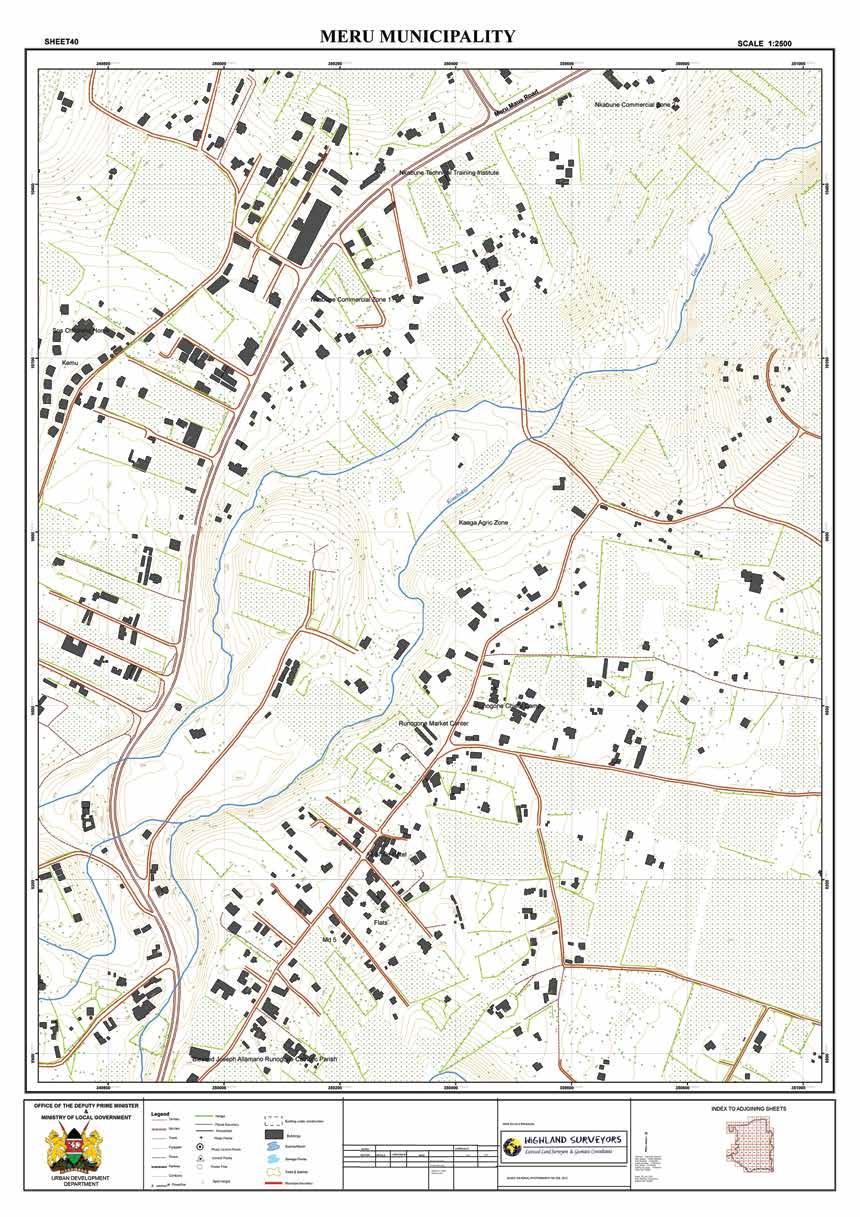
6 PROJECT CLIENT CADASTRAL SURVEYS Cadastral survey and title preparation for 100 plots. Moi University, Eldoret. Cadastral survey of 1131 hectares, plus title preparation. Vita Cress Kenya Ltd., Nanyuki Cadastral survey and title preparation of 100 plots. Kerio Valley Development Authority (KVDA), Eldoret PROJECT CLIENT DIGITAL PHOTOGRAMMETRIC MAPPING 120 Km² for preparation of strategic urban development plans of Meru Municipality and adjacent areas. Ministry of Local Government 40 km² for preparation of strategic urban development plans of Mtwapa. Ministry of Local Government 40 km long by 3 km wide for Kenya Pipeline wayleave in Mombasa. Kenya Pipeline Company 65 km long by 3 Km wide Londiani Fort Ternan-Muhoroni road reserve in Western Kenya. 45 km long by 3km wide Sigalagala Sidindi Road reserve in Western Kenya. Ministry of Roads and Public Works Survplans Limited 36 km long by 3 km wide Kenya Pipeline wayleave in Nairobi. Kenya Pipeline Company Satellite mapping and boundary delineation between indigenous forest and plantations, in Mount Kenya Forest and National Reserve. United Nations Environmental Programme 40 percent of Nairobi County. JICA HIGHLAND SURVEYORS COMPANY PROFILE

7 CLIENT LIST PROJECT CLIENT ONGOING PROJECTS Digital photogrammetric mapping for preparation of strategic urban development plans of Wajir County. Ministry of Local Government Digital photogrammetric mapping for preparation of strategic urban development plans of Marakwet County. Ministry of Local Government Cadastral survey of 57 km long by 3km wide Marua -Makutano Junction road reserve. Kenya National Highways Authority
8 HIGHLAND SURVEYORS COMPANY PROFILE

9 CASE SAMPLES SELECTED CASES LARGE-SCALE TITLE PROCESSING FOR COMPREHENSIVE DEVELOPMENT Lonrho Africa aimed to subdivide a 50,000-acre holding in Eldoret into a multi-use development featuring agricultural, residential, and industrial plots of acres each. Highland Surveyors completed the physical planning, environmental assessment, and obtained approvals from government departments at the local and national levels. Cadastral survey and processing of the 3,000 titles was done in just six months. LARGE-SCALE TITLE PROCESSING TO LAY THE GROUNDWORK FOR KENYA S ADVANCED TELECOMS INDUSTRY The parastatal Kenya Post and Telecommunications owned hundreds of plots scattered throughout the country, dating back to the early 1950s. While many housed very expensive towers and other key telecommunications equipment, the plots lacked any documentation of ownership. Highland Surveyors successfully processed the part development plans and letters of allotment, carried out title surveys, secured approvals from scores of local authorities, and prepared the hundreds of titles. This effort literally laid the groundwork for privatizing the telecommunications industry, since only with secure titles could the parastatal attract the investment that would ultimately make Kenya a telecommunications leader.
10 SELECTED CASES SATELLITE MAPPING FOR ENVIRONMENTAL MANAGEMENT OF THE MT. KENYA ECOSYSTEM Highland Surveyors performed satellite mapping of the entire Mt. Kenya ecosystem showing vegetation, soil types, and land use. These detailed images enabled the government to make strategic decisions regarding which agency-- the Kenya Wildlife Service or the Kenya Forest Service would maintain jurisdiction over which areas of the ecosystem. AERIAL MAPPING FOR STRATEGIC URBAN PLANNING To help the Ministry of Local Government better plan urban growth in and around Meru, Mtwapa and Wajir Counties, Highland Surveyors is now performing digital aerial topographical mapping of these towns. This is the first time some of these areas have been mapped in sufficient detail to enable physical planning for sustainable, regulated urban development. THE OFFICIAL, STATE-OF-THE-ART, TOPOGRAPHICAL MAP OF MUCH OF NAIROBI Requested by Japan International Cooperation Agency (JICA), Highland Surveyors, using the latest photogrammetric techniques, produced the latest official map of 40 percent of Nairobi County, at a scale of 1:10,000. This digital topographical map forms the basis of a significant amount of planning for infrastructure, residential and other development projects. HIGHLAND SURVEYORS COMPANY PROFILE
11 INTRODUCTION
12 WHAT CAN WE DO FOR YOU? CONTACT US AT TEL: ; ;
Cadastre in Addis Ababa. Status and future development
 Status and future development Dr.-Ing. Paul Hartfiel Mülheim, 1. Oct. 2010-1 - Addis Ababa Capital of Ethiopia Area population 540 km² > 3,200,000 (rapidly growing) 2,300,000 in 1994 > 22% of all urban
International funding projects in Republic Geodetic Authority
 International funding projects in Republic Geodetic Authority Serbia: Republic Geodetic Authority Workshop Exploring Funding Instruments for NMCA 7-8 November 2012 Republic Geodetic Authority Republic
By: Barney I. S. Laseko Programme Coordinator Prime Minister s Office TANZANIA
 2014 CONFERENCE ON LAND POLICY IN AFRICA 11 14 NOVEMBER, 2014 Focussed Discussion VIII Converting from Manual Land Registration to GIS Enabled Land Information System Case of Sub Saharan Africa Tanzania
PANAFRICA GEOINFORMATION SERVICES PLC ETHIOPIA
 PANAFRICA GEOINFORMATION SERVICES PLC ETHIOPIA Tenets PanafricaGIS is a technology-enthusiast company operated by experienced professionals in the field of geo-information. We believe a sustained and inclusive
Section I General Information
 General Information Table of Contents A. Introduction... I-2 1. Purpose... I-2 2. Scope... I-2 3. Maintenance... I-3 4. Units... I-3 B. Public Relations... I-3 1. General Public... I-3 2. Property Owners...
FORMAL URBAN LAND SUPPLY IN KENYA: THEORY AND PRACTICE. By Rose M. Musyoka, PhD Department of Physical Planning, Ministry of Lands, Kenya
 FORMAL URBAN LAND SUPPLY IN KENYA: THEORY AND PRACTICE By Rose M. Musyoka, PhD Department of Physical Planning, Ministry of Lands, Kenya CONTEXT Kenya s colonial history has influenced land access and
Our policy of providing clients a personal service has been rewarded by a wide and diverse client base with high-level repeat commissions.
 1.0 Introduction Datum Surveying Consultants has professional, technical resources, equipment, experience and training to undertake any type of Survey and Mapping project expediently. Since inception in
GLOBAL GEOSPATIAL MANAGEMENT INFORMATION
 GLOBAL GEOSPATIAL MANAGEMENT INFORMATION SEOUL, KOREA 24 th to 26 th October 2011 COUNTRY REPORT - REPUBLIC OF BOTSWANA 1. INTRODUCTION 1.1. SOCIAL, ECONOMIC AND POLITICAL BACKGROUND Botswana attained
EXCELLENCE IN SURVEYING AWARD,
 EXECUTIVE SUMMARY Cottrell Cameron & Steen Surveys Pty Ltd is a private, survey company registered with the Surveyors Board of Queensland and an accredited surveyor with the Department of Natural Resources
Presenter: Arch. Emma Miloyo President (Architectural Association of Kenya)
") Presenter: Arch. Emma Miloyo President (Architectural Association of Kenya) Q2: Unlocking government s land bank to serve local and foreign investors - how will this roll out? There is no one single
Presenter: Arch. Emma Miloyo President (Architectural Association of Kenya) Q2: Unlocking government s land bank to serve local and foreign investors - how will this roll out? There is no one single
Towards Kenya s Profile of the Land Administration Domain Model
 Department of Geospatial and Space Technology University of Nairobi Towards Kenya s Profile of the Land Administration Domain Model David N. Siriba and Jasper N. Mwenda dnsiriba, jnmwenda{@uonbi.ac.ke}
LAND ADMINISTRATION DEVELOPMENTS IN RWANDA
 LAND ADMINISTRATION DEVELOPMENTS IN RWANDA, Rwanda Key words : Land tenure security, land registration, land rights, land commissions. SUMMARY : The new Rwandan land policy consider appropriate land administration
EXPRESSION OF INTEREST (EOI)
") PROPOSED TRADE & DEVELOPMENT (TDB) NAIROBI OFFICE DEVELOPMENT PLOT L.R NO. 1/184 LENANA ROAD ART CURATOR/MANAGER TENDER NO TDB/NOD/01/06/17 EXPRESSION OF INTEREST (EOI) ARCHITECTS PLANNING SYSTEMS SERVICES
PROPOSED TRADE & DEVELOPMENT (TDB) NAIROBI OFFICE DEVELOPMENT PLOT L.R NO. 1/184 LENANA ROAD ART CURATOR/MANAGER TENDER NO TDB/NOD/01/06/17 EXPRESSION OF INTEREST (EOI) ARCHITECTS PLANNING SYSTEMS SERVICES
Use of data in Ukraine for sustainable economic growth. Oleksandr Maliuk State Service of Ukraine for Geodesy, Cartography and Cadastre
 Use of data in Ukraine for sustainable economic growth Oleksandr Maliuk State Service of Ukraine for Geodesy, Cartography and Cadastre Kehl, 2017 Content of the presentation Ukraine & StateGeoCadastre:
2016 LANDU Course Descriptions. Agricultural Land Brokerage and Marketing
 2016 LANDU Course Descriptions Agricultural Land Brokerage and Marketing Gain an understanding of the basics of agricultural land brokerage process s well as insights on how to best market these types
The Fit- for-purpose Concept
 The Fit- for-purpose Concept Building Spatial Frameworks for Sustainable Land Governance in Sub-Sahara Africa Prof. Stig Enemark Honorary President Aalborg University, Denmark LAND POLICIES AND LAND GOVERNANCE,
University of Nairobi LAND INFORMATION SYSTEM FOR LAND MANAGEMENT IN KENYA. CASE STUDY: NAIROBI COUNTY, BURUBURU PHASE I ESTATE
 University of Nairobi LAND INFORMATION SYSTEM FOR LAND MANAGEMENT IN KENYA. CASE STUDY: NAIROBI COUNTY, BURUBURU PHASE I ESTATE BY Justus Amdavi F56/69371/2013 Supervisor: Mr Jasper Mwenda CONTENTS Introduction
Cadastral Development in Norway and Need for Improvements
 Cadastral Development in Norway and Need for Improvements Leiv Bjarte MJØS, Norway Key words: Cadastre, Cadastral Surveying, Cadastral Development, Land Register, Land Registration, Boundary Disputes SUMMARY
SMITH LAND SURVEYORS COMPANY PROFILE MELBOURNE I GEELONG I SURF COAST I BELLARINE
 SMITH LAND SURVEYORS COMPANY PROFILE MELBOURNE I GEELONG I SURF COAST I BELLARINE Company Profile Smith Land Surveyors is a licensed survey and development consultancy company specialising in both cadastral
PROJECT INFORMATION DOCUMENT (PID) CONCEPT STAGE Report No.: AB3229 Project Name. Land Registry and Cadastre Modernization Project Region
 CONCEPT STAGE Report No.: AB3229 Project Name. Land Registry and Cadastre Modernization Project Region") PROJECT INFORMATION DOCUMENT (PID) CONCEPT STAGE Report No.: AB3229 Project Name Land Registry and Cadastre Modernization Project Region EUROPE AND CENTRAL ASIA Sector Central government administration
PROJECT INFORMATION DOCUMENT (PID) CONCEPT STAGE Report No.: AB3229 Project Name Land Registry and Cadastre Modernization Project Region EUROPE AND CENTRAL ASIA Sector Central government administration
Actual Developments of Land Consolidation in Finland. Mikko UIMONEN, Finland
 Actual developments of land consolidation in Finland Mikko UIMONEN, Finland Key words: Land consolidation, Land rearrangement, Reallotment of parcels, Quality management SUMMARY This paper describes the
The Necessity for Interdisciplinary Cooperation as a Part of FIG Activity
 The Necessity for Interdisciplinary Cooperation as a Part of FIG Activity Joseph KRAUS, Joseph FORRAI, Israel Key words: interdisciplinary cooperation, surveyor s key role, surveyor s position SUMMARY
Extending limits of space. Geodetski zavod Celje
 Extending limits of space Geodetski zavod Celje Let us introduce International company based in Slovenia with 55 years of experience providing consulting and technical assistance services to public sector
Directorate of Survey and Mapping NAMIBIA. Cadastral Information System. Vehupisa Kasuko Tjatindi Surveyor Directorate of Survey and Mapping NAMIBIA
 Vehupisa Kasuko Tjatindi Directorate of Survey and Mapping NAMIBIA Tel: +64 61 965000 Directorate of Survey and Mapping NAMIBIA Cadastral Information System Introduction Over the past few decades cadastral
Land Administration Developments in Rwanda
 Land Administration Developments in Rwanda Eugène RURANGWA Expert Group Meeting on secure land tenure new legal frameworks and tools UN-Gigiri, Nairobi, 10-12 November, 2004 Contents Somme figures about
The Survey Data Model Technology A practical survey solution to generate all levels of spatial and e-governance outcomes.
 Land Governance in a Rapidly Changing Environment Annual World Bank Conference on Land and Poverty April 24 & 25, 2012 The Survey Data Model Technology A practical survey solution to generate all levels
THE APPLICATION OF GIS AND LIS Solutions and Experiences in East Africa. Lenny Kivuti
 Using GIS and LIS for Planning Sustainable Development Bepic Group CHOGM, Malta 2005 THE APPLICATION OF GIS AND LIS Solutions and Experiences in East Africa Lenny Kivuti 21 November, 2005 Presented by
A Vision for a Fully Digital Cadastral Survey System
 A Vision for a Fully Digital Cadastral Survey System Anselm HAANEN, Trent GULLIVER, New Zealand Key words: cadastral survey system, digital cadastre, survey plans SUMMARY Surveyors have traditionally prepared
Development of Cadastral Survey and Land Ownership Registration System in Mongolia
 Development of Cadastral Survey and Land Ownership Registration System in Mongolia M.Saandar,, Ph. D Vice President, the Mongolian Association of Surveying and Mapping, ( As National Member of FIG ) MonMap
PREPARING SURVEY TENDER GIS DATABASE OUTCOMES
 PREPARING SURVEY TENDER SPECIFICATIONS FOR PROJECT GIS DATABASE OUTCOMES Presentation by Ian Harper GEODATA AUSTRALIA ESRI User Conference 2009 24 st July 2009 BACKGROUND GIS databases now provide a more
BULGARIAN CADASTRE A GUARANTEE FOR THE OWNERSHIP RIGHTS IN IMMOVABLE PROPERTIES
 4 TH INTERNATIONAL CONFERENCE RECENT PROBLEMS IN GEODESY AND RELATED FIELDS WITH INTERNATIONAL IMPORTANCE February 28 - March 2, 2007, Inter Expo Centre, Sofia, Bulgaria BULGARIAN CADASTRE A GUARANTEE
East Coast Positioning Pty Ltd
 East Coast Positioning Pty Ltd PO Box 7388, Baulkham Hills NSW 2153 Phone 0408 556 914 (Mony Seng) ms@ecpsurveyors.com.au Website: www.ecpsurveyors.com.au East Coast Positioning Pty Ltd Page 1 THE COMPANY
The Digital Cadastral Database and the Role of the Private Licensed Surveyors in Denmark
 IRISH INSTITUTE OF SURVEYORS, DUBLIN INSTITUTE OF TECHNOLOGY, 23 NOVEMBER 2005 PUBLISHED IN IIS NEWS, WINTHER 2006. The Digital Cadastral Database and the Role of the Private Licensed Surveyors in Denmark
IMPLEMENTATION OF FLEXICADASTRE IN ZAMBIA
 IMPLEMENTATION OF FLEXICADASTRE IN ZAMBIA Presented by: Simon M. Mwalimu Head of Mining Cadastre and Secretary of The Mining Advisory Committee Mining Cadastre Office-Zambia 16 th February 2009 Part A
National Report. Submitted by Cyprus **
 UNITED NATIONS E/CONF.97/5/CRP. 12 ECONOMIC AND SOCIAL COUNCIL Seventeenth United Nations Regional Cartographic Conference for Asia and the Pacific Bangkok, 18-22 September 2006 Item 6 (b) of the provisional
FIG-WB Forum on Land Administration and reform in Sub-Sahara Africa
 FIG-WB Forum on Land Administration and reform in Sub-Sahara Africa Chris Mnyanga Ministry of Lands UNITED REPUBLIC OF TANZANIA] FIG WORKING WEEK, Abuja, NIGERIA 2013-6-10 MAY 2013 Country at Glance UNITED
A Geocoded Cadastral Fabric as a Precondition for a Sustainable Land Management System
 A Geocoded Fabric as a Precondition for a Sustainable Land Management System Gottfried KONECNY, Germany; J.P. LAUZON, Canada; Abdul Salam MOHAMMED, India Key words: SDI,, Parcel Boundaries, GPS-GNSS, Land
The Boundary and the Effects of Cadastral Surveying in Cyprus
 The Boundary and the Effects of Cadastral Surveying in Cyprus Aristi Louca, Margarita Fani Surveyor Engineers, Cyprus Association of Rural and Surveying Engineers The History of Cyprus goes back 11000
Ownership Data in Cadastral Information System of Sofia (CIS Sofia) from the Available Cadastral Map
 from the Available Cadastral Map") Ownership Data in Cadastral Information System of Sofia (CIS Sofia) from the Available Cadastral Map Key words: ABSTRACT Lydmila LAZAROVA, Bulgaria CIS Sofia is created and maintained by GIS Sofia ltd,
Ownership Data in Cadastral Information System of Sofia (CIS Sofia) from the Available Cadastral Map Key words: ABSTRACT Lydmila LAZAROVA, Bulgaria CIS Sofia is created and maintained by GIS Sofia ltd,
Integration of Landregistry and Cadastre in the Netherlands. Presentation by Wim Louwman Chief registrar
 Integration of Landregistry and Cadastre in the Netherlands Presentation by Wim Louwman Chief registrar Programme Legal system in the Netherlands. History: - 1832: seperated public registers (Landregistry)
Implementing Norwegian funded projects with the State Geodetic Administration in Croatia
 Implementing Norwegian funded projects with the State Geodetic Administration in Croatia Fredrik Steiwer Managing Director Project Management and Mapping AS PMM? Project Management and Mapping AS (PMM)
INTRODUCTION. Regulation of GI as stated in the Law of Indonesia No. 4 of 2011 about
 FRANKO JHONER, SH As Speaker at Geospatial World Forum 2014, Legal Drafter at The Indonesian Geospatial Information Agency (Badan Informasi Geospasial, Republik Indonesia) Geneva - Switzerland TITLE: PERMISSION
THE NIGERIAN INSTITUTION OF SURVEYORS
 THE NIGERIAN INSTITUTION OF SURVEYORS PROFESSIONAL SCALE OF FEES 2017 (BASED ON 1996 FED. GOVT. APPROVED SCALE OF FEES FOR CONSULTANTS IN THE CONSTRUCTION INDUSTRY) TABLE OF CONTENTS Pages Preface 3 Introduction
ULIGANI HOUSE. Nanyuki, Kenya
 ULIGANI HOUSE Nanyuki, Kenya Situated on an expansive 81.39 acre (32.94 ha) piece of ranch land just outside Nanyuki is Uligani House a very impressive and elegant home. Built in 2008 by master builder,
COUNTY GOVERNMENT OF KIAMBU COUNTY PUBLIC SERVICE BOARD P.O BOX KIAMBU VACANCIES
 COUNTY GOVERNMENT OF KIAMBU COUNTY PUBLIC SERVICE BOARD P.O BOX 2362-00900 KIAMBU VACANCIES Kiambu County Public Service Board wishes to recruit competent and qualified persons to fill the following positions
Reforming the Land Sector in Jamaica
 Silburn CLARKE and Llewelyn ALLEN, Jamaica Key words: tenure, cadastre, land reform, adjudication, public awareness, land titling, GPS, parcel mapping, traversing, land legislation, tenure regularisation,
FROM RESIDENTIAL LICENSES TO FULL TITLE IN TANZANIA
 FORMALISATION OF LANDED PROPERTIES IN UNPLANNED SETTLEMENTS FROM RESIDENTIAL LICENSES TO FULL TITLE IN TANZANIA by Sarah A. Kyessi, Assistant Director Settlements Regularisation Ministry of Lands Housing
Responsible and Innovative Land Administration
 Responsible and Innovative Land Administration An Example from Ethiopia 3 RD DECEMBER 2018 Outline A few words about NIRAS Fit-for-purpose: A low-tech disruptive approach? The REILA Project in Ethiopia
INTRODUCTION - Land is the platform of all societies activities. - Land policy regulates the access to land and the management of land.
 INTRODUCTION - Land is the platform of all societies activities. - Land policy regulates the access to land and the management of land. - An acceptable and proactive land policy is a critical success factor
Cadastre: definitions
 Introduction New vision towards a multipurpose cadastral system to support land management in Morocco Moha EL-AYACHI, El Hassane SEMLALI, Mohamed ETTARID, Driss TAHIRI, Institut Agronomique et Vétérinaire
Information System of Electronic Cadastre Registration of Lands in Azerbaijan
 The State Committee on Property Issues of the Republic of Azerbaijan Information System of Electronic Cadastre Registration of Lands in Azerbaijan Chıngız Tanırverdiyev-chief engineer Cadastre and Land
e-land Administration in Hungary
 e-land Administration in Hungary Piroska Zalaba senior counsellor, project manager Ministry of Agriculture and Rural Development Department of Lands and Mapping FIG SEMINAR Innsbruck, 2-4 June 2004 Land
The programme is implemented
 Surveying Property valuation and spatial data tools to assist in land restitution by Jaco de Kock, GISCOE Land and tenure reform in the South African government context are beyond talk and have received
Cadastral Template 2003
 PCGIAP-Working Group 3 "Cadastre" FIG-Commission 7 "Cadastre and Land Management" Cadastral Template 2003 The establishment of a cadastral template is one of the objectives of Working Group 3 "Cadastre"
Iranian Cadastre System. Nasrollah Jahangard Iran s Deeds and Properties Registration Organization I.R. of Iran 14 th PCGIAP, KL, Malaysia 2008
 Iranian Cadastre System Nasrollah Jahangard Iran s Deeds and Properties Registration Organization I.R. of Iran 14 th PCGIAP, KL, Malaysia 2008 General Information Europe Middle East Asia Africa Middle
AFRICA REGIONAL NETOWORK
 Facing the Global Agenda - The Role of Land Professionals Prof. Stig Enemark FIG Honorary President Aalborg University, Denmark AFRICA REGIONAL NETOWORK Challenges and Opportunities in Facing the SDG s:
California-Specific Professional Land Surveyor Examination Test Plan
 General Definition of California Professional Land Surveying Practices: The practice of land surveying in the State of California consists of determining, establishing, reporting and mapping the positions,
Analytical Cadastre in Israel: Restoring Land Boundaries Based on Photogrammetric Tools
 Analytical Cadastre in Israel: Restoring Land Boundaries Based on Photogrammetric Tools Yohanan GAVISH and Prof. Yerach DOYTSHER, Israel Key words: analytical cadastre; photogrammetry; restoring land boundaries;
Cadastral Information System of Sofia
 Alexander LAZAROV and Hristo DECHEV, Bulgaria Key words: ABSTRACT A new Cadastre and Property Register Act (CPRA) was passed in April 2000, setting up rules for the maintenance of these two registers.
FIG Congress 2010 Facing the Challenges Building the Capacity Sydney, Australia, April
 Setting up the infrastructure for improving the development of Cadastre in Greece Dr. Dimitris ROKOS, Dr. Konstantinos KYRIAZIS and Dr. Panos LOLONIS KTIMATOLOGIO S.A. (Hellenic Cadastre) Source: wikipedia
GIS & GPS Applications in Valuation/Appraisal Assessments
 GIS & GPS Applications in Valuation/Appraisal Assessments Simon ADCOCK, Australia Key words: GIS, GPS, mass assessments, 3-dimensional, modelling. SUMMARY The development of GIS and GPS systems has substantially
Land Administration and Spatial Enablement Victoria s Experience. Chris McRae, Executive Director Land Victoria
 Land Administration and Spatial Enablement Victoria s Experience Chris McRae, Executive Director Land Victoria 4 th UN Land Administration Forum, October 2011 Outline About Land Victoria Land Victoria
The development of a GIS for an informal settlement. Benita NORDIN, Swedesurvey AB
 Benita NORDIN, Swedesurvey AB Key words: GIS, informal settlement, land tenure, adjudication SUMMARY The purpose of the paper is to try to show examples of the use of GIS as one of the tools for solving
TERMS OF REFERENCE FOR CONSULTANCY SERVICES TO PREPARE PROJECT DOCUMENT FOR CADASTRAL MAPPING IN THE GAMBIA
 Ministry of Lands and Regional Government United Nations Development Program UNDP April 2017 TERMS OF REFERENCE FOR CONSULTANCY SERVICES TO PREPARE PROJECT DOCUMENT FOR CADASTRAL MAPPING IN THE GAMBIA
ABSTRACT Land Administration System in Lithuania
 ABSTRACT Land Administration System in Lithuania 1. General introduction to the Lithuanian Land Administration System and State Enterprise Centre of Registers ( shortly SECR) Lithuania has established
ASSESSMENT OF STATE AGENCIES WITH RESPONSIBILITIES FOR LANDS AND OTHER REAL PROPERTIES
 ASSESSMENT OF STATE AGENCIES WITH RESPONSIBILITIES FOR LANDS AND OTHER REAL PROPERTIES CHAGUARAMAS DEVELOPMENT AUTHORITY Prepared for LAND USE POLICY AND ADMINISTRATION PROJECT [LUPAP] Agriculture Sector
Incorporating Sustainable Development Objectives into ICT Enabled Land Administration Systems - Case Study Switzerland
 EXPERT GROUP MEETING ON INCORPORATING SUSTAINABLE DEVELOPMENT OBJECTIVES INTO ICT ENABLED LAND ADMINISTRATION SYSTEMS 9-11 November 2005, Centre for Spatial Data Infrastructures and Land Administration
TSO1C: Land Reforms. Commission 7
 TSO1C: Land Reforms. Commission 7 Development of & Implementation LIS. Building an effective Partnership to Reform Uganda s Land Administration (7320) Gasant Jacobs, Head: Business Development. Tax & Accounting
A Study on Use of Cadastre Information for Management of Urban Facility
 In-Je WOO and Joon-Sung YUN, Republic of Korea Key words: Cadastre, Feature, Facility, Management, Classification, etc. SUMMARY The purpose of this study is to more effectively operate the cadastre information
Protecting Land Outside Protected Areas in Kenya. Kathleen H. Fitzgerald Director Land Conservation African Wildlife Foundation
 Protecting Land Outside Protected Areas in Kenya Kathleen H. Fitzgerald Director Land Conservation African Wildlife Foundation 25 February 2011 AWF Mission Work together with the people of Africa to ensure
Land Tenure and Geospatial Data and Technology
 Land Tenure and Geospatial Data and Technology Ioana Bouvier E3/Land and Urban, USAID Senior Geospatial Analyst January 23, 2018 January 23, 2018 1 OUTLINE 1. Overview of geospatial data and technology
Preliminary Subdivision Application (Major) (Four (4) lots or more)
 (Four (4) lots or more)") Gunnison City Offices www.gunnisoncity.org 38 West Center Gunnison, Utah 84634 (435) 528 7969 Date of Application: Preliminary Subdivision Application (Major) (Four (4) lots or more) APPLICANT INFORMATION
Gunnison City Offices www.gunnisoncity.org 38 West Center Gunnison, Utah 84634 (435) 528 7969 Date of Application: Preliminary Subdivision Application (Major) (Four (4) lots or more) APPLICANT INFORMATION
MASS REGISTRATION OF LAND PARCELS USING FIT-FOR-PURPOSE LAND ADMINISTRATION: PROCEDURES AND METHODS
 MASS REGISTRATION OF LAND PARCELS USING FIT-FOR-PURPOSE LAND ADMINISTRATION: PROCEDURES AND METHODS TAREK ZEIN Hansa Luftbild AG, Germany zein@hansaluftbild.de Paper prepared for presentation at the 2017
Canadian Generally Accepted Land Sur veying Principles
 Canadian Council on Geomatics Conseil canadien de géomatique Canadian Generally Accepted Land Sur veying Principles Part 1 Principles to guide the development of Land Surveying governance models and legal
15 July Ms E Young Team Leader Protected Area Establishment Department of Environment and Natural Resources Adelaide
 15 July 2011 Ms E Young Team Leader Protected Area Establishment Department of Environment and Natural Resources Adelaide PROTECTED AREAS ON PRIVATE LAND DISCUSSION PAPER The Environmental Defenders Office
Mombasa. With some of the most spectacular views of the Indian Ocean and one of the world s most
 G A L U Mombasa Home to pristine white beaches and coconut palms; thriving coral reefs and exotic sea life; abundant recreational activities and celebrated restaurants. The second largest city in Kenya,
ArcCadastre Implementations within the Middle East
 ArcCadastre Implementations within the Middle East Kholoud Saad SALAMA, Egypt Key words: Cadastre, GIS, Survey, Data Conversion, Workflow SUMMARY In recent years, cadastre systems have developed from manual
From Measurement to Management
 From Measurement to Management The changing role of the land surveyors Prof. Stig Enemark Aalborg University, Denmark LAND MANAGEMENT AND HUMAN RIGHTS INTERNATIONAL SEMINAR, HØGSKOLEN I BERGEN, 8 9 SEPTEMBER
APPLICATION OF GEOGRAPHIC INFORMATION SYSTEM IN PROPERTY VALUATION. University of Nairobi
 APPLICATION OF GEOGRAPHIC INFORMATION SYSTEM IN PROPERTY VALUATION Thesis Presented by STEPHEN WAKABA GATHERU F56/69748/2013 Supervised by DR. DAVID NYIKA School of Engineering Department of Geospatial
Integrated Safeguards Data Sheet (Initial)
") Public Disclosure Authorized Public Disclosure Authorized Public Disclosure Authorized Public Disclosure Authorized Integrated Safeguards Data Sheet (Initial) Section I - Basic Information Date Prepared/Updated:
Public Disclosure Authorized Public Disclosure Authorized Public Disclosure Authorized Public Disclosure Authorized Integrated Safeguards Data Sheet (Initial) Section I - Basic Information Date Prepared/Updated:
The Contribution of Forest Owners Associations for the Forest Cadastre Implementation. João Gaspar Ana Navarro Ferreira PORTUGAL
 The Contribution of Forest Owners Associations for the Forest Cadastre Implementation João Gaspar Ana Navarro Ferreira PORTUGAL Motivation Lack of forestry cadastre; Unify all FOAs databases with common
The Croatian Surveyor Guaranteeing Land Property
 Croatian Chamber of Chartered Geodetic Engineers Zagreb, Croatia www.hkoig.hr The Croatian Surveyor Guaranteeing Land Property Ph. D. Danko Markovinović The Cadastral Surveyor paving the Way to the Future
Kennedy Surveying REGISTERED PROJECT SURVEYORS. Company Profile
 Kennedy Surveying REGISTERED PROJECT SURVEYORS Company Profile Vision and Services Corporate Overview: Kennedy Surveying is a progressive, well established family owned business that provides specialist
Universal Geo-database Connector Interface Component (UG-CIC) For Virtual Web-base GIS Server Essential For Real Estate Industry Uses
 For Virtual Web-base GIS Server Essential For Real Estate Industry Uses") Universal Geo-database Connector Interface Component (UG-CIC) For Virtual Web-base GIS Server Essential For Real Estate Industry Uses Jad Jarroush & Dr. Kobi Zaid Zaid Orniv Group L.T.D Israel kobi_z@zaidorniv.co.il
Universal Geo-database Connector Interface Component (UG-CIC) For Virtual Web-base GIS Server Essential For Real Estate Industry Uses Jad Jarroush & Dr. Kobi Zaid Zaid Orniv Group L.T.D Israel kobi_z@zaidorniv.co.il
FACT SHEET: Tenure requirements for Major Customer Connections
 FACT SHEET: for Major Customer Connections Purpose February 2014 Version 1.0 This fact sheet describes the types of underlying land tenure required by Ergon Energy in situations where a Major Customer
Surveying and Mapping Strategy for Supporting the Emerging Land Market in Albania
 No. 2 A L B A N I A S E R I E S September 1997 Surveying and Mapping Strategy for Supporting the Emerging Land Market in Albania Ahmet Jazoj, Spiro Lamani, Leart Lira SURVEYING AND MAPPING STRATEGY FOR
Ministry of Mines, Industry and SME
 Republic of Senegal Ministry of Mines, Industry and SME User Conference 2010 08/02/2010 COPYRIGHT 2010. SPATIAL DIMENSION (PTY) LTD. A MINING CADASTRE IN SENEGAL: IMPLEMENTATION PROCESS AND ORGANIZATIONAL
Land Administration System in Russian Federation
 Sergey VOLKOV, Russia Key words: land administration, market economy, land management, land resources. SUMMARY Principle source of economic and social development of Russian Federation in XXI century will
Building Fit for Purpose Land Administration Systems - World Bank Experience
 Building Fit for Purpose Land Administration Systems - World Bank Experience Gavin Adlington Lead Land Administration Specialist The World Bank Fit For Purpose The only way to establish a successful land
Full Report Released: 14 th October 2014
 i Full Report Released: 14 th October 2014 Contact us at: Prof. Nelson Awori Centre, 5th Floor, Suite B6 Tel: +254 (020) 271 45 74 / +254 706 623 636 / +254 731 475 034 Postal Address: 8222 00100, Nairobi
REDAN CAPITAL LTD 13 Ikeja Close, Off oyo St, Area 2, Garki-, Abuja, Nigeria GUIDELINES FOR PREPARING PROJECT PROPOSALS
 GUIDELINES FOR PREPARING PROJECT PROPOSALS INTRODUCTION SHELTER-AFRIQUE's major objective is to promote housing in Africa. In order to achieve this objective, the Company cooperates with private sector,
CARMACOUP FOREST Glespin, South Lanarkshire Hectares / Acres
 CARMACOUP FOREST Glespin, South Lanarkshire 310.50 Hectares / 767.24 Acres FREEHOLD FOR SALE AS A WHOLE John Clegg & Co Chartered Surveyors CARMACOUP FOREST Glespin 1 mile Irvine 35 miles Lockerbie 46
Challenges to Effective Land Governance in Trinidad and Tobago
 Charisse GRIFFITH-CHARLES, Trinidad and Tobago Key words: land administration, land governance SUMMARY Various technological and legislative solutions present themselves to alleviate land governance issues.
GAUSSCAD A WEBGIS APPLICATION FOR COLLECTING CADASTRAL DATA
 M.M. Moise GaussCAD a WebGIS Application for Collecting Cadastral Data GAUSSCAD A WEBGIS APPLICATION FOR COLLECTING CADASTRAL DATA Mihai-Mircea MOISE, S.C. GAUSS S.R.L., mihai.moise@gauss.ro Abstract:
Marine Spatial Data Infrastructure (MSDI) & The Marine Cadastre Application. April 10, 2018
 & The Marine Cadastre Application. April 10, 2018") Marine Spatial Data Infrastructure (MSDI) & The Marine Cadastre Application April 10, 2018 A Collaborative Pilot Project Vision of CHS: A framework of geographic data, metadata, users and tools Intent
Marine Spatial Data Infrastructure (MSDI) & The Marine Cadastre Application April 10, 2018 A Collaborative Pilot Project Vision of CHS: A framework of geographic data, metadata, users and tools Intent
Improvement of Effectiveness Present Developments in Hungarian Land Administration
 Improvement of Effectiveness Present Developments in Hungarian Land Administration Gyula IVÁN and András OSSKÓ, Hungary Key words: Land Administration, Cadastre, Land Registry SUMMARY New Act on Surveying
LLANO CENTRAL APPRAISAL DISTRICT REAPPRAISAL PLAN FOR TAX YEARS 2017 & 2018 AS ADOPTED BY THE BOARD OF DIRECTORS
 LLANO CENTRAL APPRAISAL DISTRICT REAPPRAISAL PLAN FOR TAX YEARS 2017 & 2018 AS ADOPTED BY THE BOARD OF DIRECTORS TABLE OF CONTENTS ITEM PAGE Executive Summary 5 Revaluation Decision (Statutory or Administrative)
Capability Statement Town Planning, Cadastral & Development
 Capability Statement Town Planning, Cadastral & Development www.urbanandrural.com.au feedback@northgroup.com.au Who are Urban & Rural Urban and Rural is a specialist town planning, cadastral and development
Good Land Governance for the 2030 Agenda
 Good Land Governance for the 2030 Agenda Addis Ababa, Ethiopia 20-22 April, 2014 Role of Geospatial Information in Good Land Policy and Governance Oumar Sylla UN-Habitat/GLTN oumar.sylla@unhabitat.org
FIG/FAO International Seminar on State and Public Land Management
 FIG/FAO International Seminar on State and Public Land Management State Land Distribution for the Poor: State Land Identification, Mapping, Classification and Registration By Dr. Sareth Boramy Deputy General