NOTICE OF MEETING OF THE PLANNING AND ZONING COMMISSION OF BUDA, TX 7:00 PM - Tuesday, June 13, S. Main Street Buda, TX 78610
|
|
|
- Sara Lee
- 6 years ago
- Views:
Transcription

1 NOTICE OF MEETING OF THE PLANNING AND ZONING COMMISSION OF BUDA, TX 7:00 PM - Tuesday, June 13, S. Main Street Buda, TX This notice is posted pursuant to the Texas Open Meetings Act. Notice is hereby given that a Regular Planning & Zoning Meeting of the City of Buda, TX, will be held at which time the following subjects will be discussed and may be acted upon. A. CALL TO ORDER A.1. Signed Agenda B. INVOCATION Signed Agenda.pdf C. PLEDGE OF ALLEGIANCE TO THE FLAGS OF THE UNITED STATES AND TEXAS PLEDGE OF ALLEGIANCE TO THE TEXAS FLAG: Honor the Texas flag; I pledge allegiance to thee, Texas, one state under God, one and indivisible. D. ROLL CALL E. PUBLIC COMMENTS At this time, comments will be take from the audience on non-agenda related topics, for a length of time not to exceed three minutes per person. To address the Planning and Zoning Commission (P&Z), please submit a Citizen's Comment Form to the City Liaison prior to the start of the meeting. No action may be taken by the P&Z during Public Comments. F. CONSENT AGENDA F.1. Approval of the regular Planning and Zoning Commission meeting minutes dated May 23, G. PUBLIC HEARINGS F1 Minutes from pdf G.1. Hold a public hearing regarding a replat of Lot 3 out of the Bridgeport Subdivision, approximately acres, establishing Lots 3-A, 3-B, 3-C, 3-D and 3-E, located at the intersection of Robert S. Light Boulevard and Warehouse Drive (RP 17-06). G1 PH Bridgeport Replat RP pdf H. REGULAR AGENDA 1 Planning and Zoning Commission Agenda Page 1 June 13, 2017
2 H.1. Deliberation and possible action regarding a replat of Lot 3 out of the Bridgeport Subdivision, approximately acres, establishing Lots 3-A, 3-B, 3-C, 3-D and 3-E, located at the intersection of Robert S. Light Boulevard and Warehouse Drive (RP 17-06). H1 SR Bridgeport replat.pdf H1 RP 17-06_Lot 3, Bridgeport Buda Subd_U2_BBI Recommend.pdf H1 RP Bridgeport Buda Replat Lot 3.pdf H.2. Deliberation and possible action regarding a final plat for Crippen Subdivision being acres out of the J.S. Irvine Survey No. 4, Abstract No. 255, generally located south of the intersection of Manchaca Spring and South IH 35 Frontage Road (FP 17-14). H2 SR Crippen Final Plat.pdf H2 FP 17-14_Crippen Subdivision_U1_BBI Recommend.pdf H2 FP _109_rev_5_4_2017.pdf H.3. Deliberation and possible action regarding a final plat for Sunfield Phase 2 Section 8 being acres out of the George Herder Survey No. 537, Abstract No. 239, generally located near the intersection of Sunwheat Blvd and Sunfield Parkway (FP 16-25). H3 SR Sunfield Ph 2 Section 8 Final Plat.pdf H3 FP 16-25_Sunfield Ph 2 Sec 8_U2_BBI Recommend.pdf H3 FP sunfield 2-8-sheet 1through3.pdf H.4. Presentation and update regarding the Silverado PUD. H4 SR Silverado PUD.pdf H4 1a silverado basemap.pdf H Silverado PUD acres.pdf H.5. Presentation and update regarding legislative issues relevant to Planning & Zoning. I. STAFF REPORTS J. COMMISSION REQUEST FOR FUTURE AGENDA ITEMS K. ADJOURNMENT City Hall is wheelchair accessible and accessible parking spaces are available. Requests for accommodations must be made 48 hours prior to the meeting. Please contact City Hall at (512) , or FAX (512) for information or assistance. 2 Planning and Zoning Commission Agenda Page 2 June 13, 2017

3 I, the undersigned authority, do hereby certify that the above Notice of Meeting of the Planning and Zoning Commission of the City of Buda, was posted on the bulletin board in front of Buda City Hall, which is readily accessible to the public at all times, by 5:00 pm on DATE, Council Chambers are set up to publicly broadcast meetings. You may be audio and video recorded while in this facility. In accordance with Article III, Section 3.10, of the Official Code of the City of Buda, the minutes of this meeting consist of the preceding Minute Record and the Supplemental Minute Record. Details on meetings may be obtained from the Board Liaison, or video of the entire meeting may be downloaded from the website. (Portions of the Supplemental Minute Record video tape recording may be distorted due to equipment malfunction or other uncontrollable factors.) Attendance by Other Elected or Appointed Officials: It is anticipated that members of other governmental bodies, and/or city boards, commissions and/or committees may attend the meeting in numbers that may constitute a quorum of the body, board, commission and/or committee. Notice is hereby given that the meeting, to the extent required by law, is also noticed as a possible meeting of the other body, board, commission and/or committee, whose members may be in attendance, if such numbers constitute a quorum. The members of the boards, commissions and/or committees may be permitted to participate in discussions on the same items listed on the agenda, which occur at the meeting, but no action will be taken by such in attendance unless such item and action is specifically provided for on an agenda for that body, board, commission or committee subject to the Texas Open Meetings Act. 3 Planning and Zoning Commission Agenda Page 3 June 13, 2017
4 4
5 5
6 A. CALL TO ORDER CITY OF BUDA PLANNING AND ZONING COMMISSION MEETING MINUTES MAY 23, :00 P.M. Chair Strother called the meeting to order at 7:00 p.m. B. INVOCATION C. PLEDGE OF ALLEGIANCE TO THE FLAGS OF THE UNITED STATES AND TEXAS PLEDGE OF ALLEGIANCE TO THE TEXAS FLAG: Honor the Texas flag; I pledge allegiance to thee, Texas, one state under God, one and indivisible. D. ROLL CALL Commissioner Henry Altmiller Commissioner Angela Britain Commissioner Eric Ross Vice-Chair Meghan McCarthy Commissioner Clark Beach Commissioner John Ellis Chair Colin Strother Present Present Present Present Present Present Present E. PUBLIC COMMENTS At this time, comments will be taken from the audience on non-agenda related topics, for a length of time not to exceed three minutes per person. To address the Planning and Zoning Commission, please submit a Citizen Comment Form to the City Liaison prior to the start of the meeting. No action may be taken by the Planning and Zoning Commission during Public Comments No comments were made. F. CONSENT AGENDA 1. Approval of the regular Planning and Zoning Commission meeting minutes dated April 11, Commissioner Strother made the motion to approve the minutes, seconded by Commissioner Altmiller. The motion passed 6-0 with Commissioner Ross abstaining. G. REGULAR AGENDA ITEMS 1. Deliberation and possible action regarding a replat of Lot 4B, Block A, out of the Frank Y Smith Subdivision, approximately acres, establishing Lots 4B and 4C, located on the southwest side of Robert S. Light Boulevard approximately 1,200 feet east of its intersection with South FM 967/South Loop 4 (RP 16-27). Commissioner Altmiller made the motion to approve the minutes, seconded by Commissioner Strother. The motion passed
7 2. Deliberation and possible action regarding a final plat for Sunfield Health Hub being acres out of the Trinidad Varcinas Survey No. 9, Abstract No. 465, generally located at the intersection of Overpass Road and Fire Cracker Drive (FP 17-05). Commissioner Strother made the motion to approve the minutes, seconded by Commissioner McCarthy. The motion passed Review and provide recommendations to the City Council on the draft Fiscal Year Capital Improvements Plan. Staff gave a presentation to the commission. H. STAFF REPORTS The Planning & Zoning Commission may discuss any of the items under Staff Reports, but no formal action will be taken. Update regarding the Unified Development Code Re-Write Update regarding the activities of other city Boards and Commissions, including the Economic Development Corporation Board. Update regarding recent and ongoing Capital Improvements Projects I. COMMISSION REQUESTS FOR FUTURE AGENDA ITEMS No deliberation or discussion may take place by the Commission during this agenda item. Commissioner Strother requested an update on the current standing of the Cabela s PUD. J. ADJOURNMENT Commissioner Altmiller made a motion to adjourn the meeting, and a second was made by Commissioner McCarthy. Upon a unanimous vote and having no further business to consider, Chair Strother adjourned the meeting at 8:42 p.m. ATTEST: Recording Secretary 7
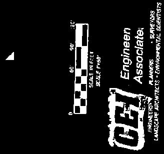
8 Planning and Zoning Commission Agenda Item Report June 13, 2017 Contact Chance Sparks, AICP, CNUa, Director of Planning / csparks@ci.buda.tx.us SUBJECT: HOLD A PUBLIC HEARING REGARDING A REPLAT OF LOT 3, OUT OF THE BRIDGEPORT, APPROXIMATELY ACRES, ESTABLISHING LOTS 3-A, 3-B, 3-C, 3-D AND 3-E, LOCATED AT THE INTERSECTION OF ROBERT S. LIGHT BOULEVARD AND WAREHOUSE DRIVE (RP 17-06). 1. EXECUTIVE SUMMARY This is the statutory public hearing for this replat. Staff has made the required public notifications in advance of this hearing, pursuant to the requirements of the city s Unified Development Code and state law. This hearing is being held in accordance with applicable state and local laws as they pertain to public hearings. 2. BACKGROUND/HISTORY N/A 3. STAFF S REVIEW AND ANALYSIS This is the public hearing aspect of a replat. Detailed analyses are found with the regular agenda item. This replat public hearing is triggered due to the increase in the number of lots resulting in the creation of more than four parcels. The public hearing puts other property owners within the subdivision on notice should there be any other restrictions that have been filed that might affect the status of this replat (a replat cannot attempt to remove any restrictions). 4. RECOMMENDATION This is the public hearing to hear public comments, but not take any action. Action on this item can be considered under the associated regular agenda item. The Chair shall open the public hearing and state the time, receive public comments, then close the public hearing and state the time. 8
9 Planning and Zoning Commission Agenda Item Report June 13, 2017 Contact Chance Sparks, AICP, CNUa, Director of Planning / csparks@ci.buda.tx.us SUBJECT: DELIBERATION AND POSSIBLE ACTION REGARDING A REPLAT OF LOT 3, OUT OF THE BRIDGEPORT, APPROXIMATELY ACRES, ESTABLISHING LOTS 3-A, 3-B, 3-C, 3-D AND 3-E, LOCATED AT THE INTERSECTION OF ROBERT S. LIGHT BOULEVARD AND WAREHOUSE DRIVE (RP 17-06). 1. EXECUTIVE SUMMARY The City of Buda has received an application to replat lot 3, of the Bridgeport Subdivision, involving acres. The replat is triggered due to resubdividing land in a manner that increases the number of lots, which also triggers public hearings. Approval of subdivision plats constitutes a ministerial action under the provisions of Texas Local Government Code Chapter 212. Staff, as well as the City s consulting engineer, has found the plat in compliance with applicable regulations. 2. BACKGROUND/HISTORY This is a replat of a portion of the Bridgeport Subdivision, originally approved in January 2012 as a three lot subdivision in Buda s ETJ. The subdivision spans between Robert S. Light and South Loop 4 (FM 967). This area was annexed into the city limits in April 2013 and is zoned I1 Light Industrial & Warehousing. The frontage along Loop 4 and Robert S Light is subject to the Gateway Corridor Overlay District as it applies to industrially-zoned properties. Robert S. Light Boulevard is fully funded for design and construction of an extension stretching from South FM 967 westward to FM 1626, and is commonly referred to as the truck bypass. This subdivision is adjacent to the proposed bypass. The project will utilize Monarch Utilities for water supply and wastewater will be provided through the City of Buda. 3. STAFF S REVIEW AND ANALYSIS The purpose of the replat is to divide Lot 3 in order to allow for the fee-simple sale of property, resulting in a 5-lot plat. Lot 3 was originally platted as a remainder when Ampersand purchased the blue building on South Loop 4/South RM 967 (Lot 1 of the Bridgeport Subdivision). 9
10 This replat public hearing is triggered due to the increase in the number of lots resulting in the creation of more than four parcels. The public hearing puts other property owners within the subdivision on notice should there be any other restrictions that have been filed that might affect the status of this replat (a replat cannot attempt to remove any restrictions). In this case, no such issues have been identified and the replat can proceed. All lots following the replat meet the necessary dimensional standards for the I1 zoning. The lots will maintain joint access (see notes 12 & 13) and joint stormwater facilities (existing drainage easement on rear of Lot 3-D). Lot 3-E serves as an access & circulation lot for joint access, aligning with the new Warehouse Drive extension on the other side of Robert S. Light. 4. FINANCIAL IMPACT Development of the Bridgeport Replat results in the creation of additional light industrial lots with reasonable & coordinated access to transportation facilities. The project will create opportunity for small-medium sized businesses producing sales tax and ad valorem tax proceeds. The development results in the payment of related development fees. 5. SUMMARY/CONCLUSION This is a conventional replat. The replat, as shown, complies with applicable codes and regulations. Plat approval is a ministerial function of the City if the final plat meets applicable codes and regulations, approval is required. 6. PROS AND CONS Pros and cons are discussed within the alternatives. 7. ALTERNATIVES As a ministerial action, few alternatives are available. Under the provisions of Texas Local Government Code Chapter 212. Staff, as well as the City s consulting engineer, has found the plat in compliance with applicable regulations. Approve as presented The applicant has satisfied the provisions of the UDC, and other applicable regulations. Denial Should this option be chosen, the City and individual members are exposed to significant liability. Specific deficiencies would need to be identified. Table Should this option be chosen, staff requests specification of the information needed in order to take action at a future date. Take No Action This option would ultimately result in a statutory approval under Chapter 212 of Local Government Code. While possible, staff does not recommend this approach. 8. RECOMMENDATION Staff recommends approval of this plat because the lots comply with the requirements of the Unified Development Code. Approval of subdivision plats constitutes a ministerial action under the provisions of Texas Local Government Code Chapter 212. Staff, as well as the City s consulting engineer, has found the plat in compliance with applicable regulations. 10
 Buda, Texas (AP 17-06) Dear Mr. Dringenberg: Binkley & Barfield, Inc.")

11 May 22, 2017 Mr. Matthew Dringenberg, P.E. Southwest Engineers, Inc. 142 Cimarron Park Loop, Suite A Buda, Texas matt.dringenberg@swengineers.com RE: Recommendation Letter: Amended Plat of Lot 3, Bridgeport Buda Subdivision Update 2 Robert S. Light (Lot 3 Bridgeport) Buda, Texas (AP 17-06) Dear Mr. Dringenberg: Binkley & Barfield, Inc. (BBI) has reviewed the resubmittal for engineering compliance on behalf of the City of Buda. BBI has determined that the resubmittal sufficiently addressed the previous comment letter. BBI recommends the plans be approved by the City of Buda for engineering compliance, contingent upon approvals by all other departments and applicable agencies. Once all approvals have been obtained, please provide one (1) original and two (2) copies of the plan set directly to Chance Sparks, Director of Planning. If you have any questions, please contact Mr. Sparks directly. Thank you. Sincerely, BINKLEY & BARFIELD, INC. Consulting Engineers Rey Gonzalez, P.E. cc: Chance Sparks (City of Buda) Meredith Johnson (City of Buda) John Nett, P.E. (City of Buda) Brian Rice, P.E. (BBI) Project file: /Plan Review/2.08/ Binkley & Barfield, Inc. Registration No. F South Lamar Boulevard, Suite Austin, Texas Tel: Fax:
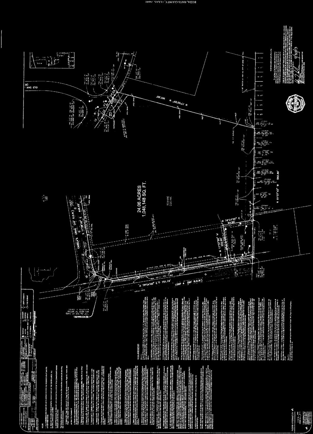
12 1ï: $ MONUMENT LEGEND / NOTES: = FOUND MONUMENT AS DESCRIBED. # $ % & ' ( ) = SURVEY MONUMENT STAMPED "SPOT ON SURVEYING" SET UPON APPROVAL. FOUND IRON ROD W/ CAP STAMPED "RPLS 4615". FOUND 1/2" IRON ROD. FOUND IRON ROD W/ CAP STAMPED "CHAPARRAL". FOUND IRON ROD W/ CAP, ILLEGIBLE. FOUND SCRIBE "+" IN CONCRETE. FOUND 1" IRON PIPE. FOUND STEEL ROD IN COVERED MONUMENT WELL, NGS (NATIONAL GEODETIC SURVEY) PID: BM0749, COORDINATES SHOWN REFLECT MEASUREMENTS PERFORMED BY SPOT ON SURVEYING ON 15/03/03, MONUMENT DATA AVAILABLE ON NGS.NOAA.GOV - HORIZONTAL DATUM: (NAD '83, TSPSC ZONE) VERTICAL DATUM: (NAVD '88) AREA CALCULATIONS: EXISTING LOT 3, (R1) 405, SQ. FT ACRES PROPOSED LOTS LOT 3-A 44, SQ. FT ACRES LOT 3-B 57, SQ. FT ACRES LOT 3-C 27, SQ. FT ACRES LOT 3-D 239, SQ. FT ACRES LOT 3-E 36, SQ. FT ACRES LOT 3, BLOCK A (R2) # REFERENCE LEGEND: (R1) BRIDGEPORT BUDA SUBDIVISION, VOLUME 16, PAGES , P.R.H.C.TX. (R2) FRANK Y. SMITH SUBDIVISION, VOLUME 19, PAGES 95-96, P.R.H.C.TX. (R3) BUDA BUSINESS CENTER SUBDIVISION, INST. NO.: , O.P.R.H.C.TX. (R4) VOL. 2870, PG. 26, O.P.R.H.C.TX. (R5) VOL. 2554, PG. 256, O.P.R.H.C.TX. (R6) VOL. 3393, PG. 708, O.P.R.H.C.TX. (R7) VOL. 4106, PG. 357, O.P.R.H.C.TX. (R8) = INST. NO.: , O.P.R.H.C.TX. D.E. = DRAINAGE EASEMENT. D.R.H.C.TX. = DEED RECORDS, HAYS COUNTY, TEXAS ' ' E.U.E. = ELECTRICAL UTILITY EASEMENT. J.U.A.E. = JOINT USE ACCESS EASEMENT. O.P.R.H.C.TX. = OFFICIAL PUBLIC RECORDS, HAYS COUNTY, TEXAS. P.R.H.C.TX. = PLAT RECORDS, HAYS COUNTY, TEXAS. W.W.E. = WASTE WATER EASEMENT R.P.R.H.C.TX. = REAL PROPERTY RECORDS, HAYS COUNTY, TEXAS. W.L.E. = WATERLINE EASEMENT M.W.E. = MONARCH WATERLINE EASEMENT S.W.E. = SIDEWALK EASEMENT 29.97' ' BOUNDARY & N= E= LOT 1, (R1) L1 L2 L3 # RE-PLAT OF LOT 3, BRIDGEPORT BUDA SUBDIVISION 15.00' ACRES, IN THE CITY OF BUDA, HAYS COUNTY, TEXAS 15' W.L.E. PER (R1) & (R7) 20' E.U.E. PER (R1) & (R6) LOT 3-D ACRES 239, SQ. FT. LOT 4, BLOCK A (R2) 6ï( ' L10 C # C1 C2 C3 C ' LOT 3-A ACRES 44, SQ. FT. DELTA ½ ï ½ ï ½ ï ½ ï C3 15' M.W.E. DEDICATED 1ï( ' HEREON CURVE TABLE RAD. R=950.59' R=950.59' R=950.59' R=925.59' 1ï( (GRID DISTANCE) N= E= C1 C ' 10' LENGTH L=228.36' L=119.28' L=109.07' L=10.01' % 15' W.W.E. PER (R8) (NTS) CHD. BEAR. 1ï: 1ï: 1ï: 1ï: ' LINETYPE LEGEND: SHEET 1 OF 3 SHEETS RIGHT OF WAY ADJOINING LOT LINES EASEMENT BROKEN LINE NOT TO SCALE (R3) CHD. L ' ' ' 10.01' ) N= E= L # L1 L2 L3 L4 L5 L6 L7 L8 L9 L10 L11 L12 L13 L14 L15 # # 1ï: ' LINE TABLE BEARING 6ï: 6ï( 6ï: 6ï( 1ï( 6ï: 1ï( 6ï( 1ï: 6ï( 1ï: 6ï: 6ï: 6ï( 6ï: L4 LENGTH 59.94' 21.20' ' ' ' 20.00' ' ' 43.45' 43.52' 82.63' ' 21.74' 44.80' 47.83' # DRAINAGE EASEMENT PER (R1) L5 1ï: ' L # L16 L17 L18 L19 L20 L21 L22 L23 L24 L25 L26 L27 L28 1ï( 74.11' LINE TABLE BEARING 6ï( 1ï( 6ï( 6ï: 6ï( 1ï( 6ï( 6ï: 1ï( 1ï( 1ï( 1ï( 1ï: LENGTH 10.00' 47.83' ' 15.84' 10.00' 15.84' 34.77' ' 10.02' ' ' ' 10.00' # # L6 L7 6ï( ' ' L9 6ï: ' 57.42' L8 # # L # L29 L30 L31 L32 L33 L34 L35 L36 L37 L38 10' WIDE W.W.E. DEDICATED HEREON SEE DETAIL "B" SHT. 3 LOT 1, (R1) 6ï( 6ï( 6ï: 6ï: 1ï( 1ï( 1ï: 6ï: 6ï: 1ï: 10.17' ' 14.44' ' ' ' 10.23' ' ' 10.00' & LOT 3-B ACRES 57, SQ. FT. L11 10' M.W.E. DEDICATED HEREON ' ' 10' S.W.E ' DEDICATED ' HEREON ' SEE DETAIL "A" SHT. 3 HOUSTON GBC, LTD. VOL. 2554, PG. 256, O.P.R.H.C.TX ACRES LINE TABLE BEARING LENGTH 1ï( LOT 3-E ACCESS LOT (NO BUILDINGS) ACRES 36, SQ. FT. W 1ï: ' ' ' ' 1ï( ' LOT 3-C ACRES 27, SQ. FT. 15' & VARIABLE WIDTH W.W.E. 1ï( ' 15' W.W.E. DEDICATED N S GRAPHIC SCALE 1" = 80' HEREON. PER (R8) 41$'465.+)*6$.8& (105' RIGHT OF WAY) 10.77' E & ' 9#4'*175'&4 $ (70' RIGHT OF WAY) ' THE MEADOWS AT BUDA COMMERCIAL, LTD. VOL. 2870, PG. 26, O.P.R.H.C.TX ACRES, PARCEL NO. 3 (R3) % SOS J/N:
13 FM 2770 F.M. 967 S. LOOP 4 FM 2001 RE-PLAT OF LOT 3, BRIDGEPORT BUDA SUBDIVISION ACRES, IN THE CITY OF BUDA, HAYS COUNTY, TEXAS SHEET 2 OF 3 SHEETS FM 967 PROJECT SITE ROBERT S. COMMERCIAL LIGHT BL VD. DR. MAIN ST. IH 35 DR. BELAS CA BEL IH 35 STATE OF TEXAS COUNTY OF HAYS OWNER'S CERTIFICATION: THAT THE UNDERSIGNED, BRIDGEPORT PROPERTIES BUDA, LLC., AN OHIO LIMITED LIABILITY COMPANY, OWNERS OF LOT 3, OF BRIDGEPORT BUDA SUBDIVISION, A SUBDIVISION IN THE CITY OF BUDA, COUNTY OF HAYS, STATE OF TEXAS OUT OF THE JAMES HURDMAN SURVEY NO. 33, ABSTRACT NO. 231, AS RECORDED IN VOLUME 16, PAGES , PLAT RECORDS, HAYS COUNTY, TEXAS, DO HEREBY RE-SUBDIVIDE SAID LOT 3, TO BE KNOWN AS LOTS 3-A, 3-B, 3-C, 3-D AND 3-E AND DO HEREBY RE-SUBDIVIDE BEING A RE-PLAT OF LOTS 3, BRIDGEPORT BUDA SUBDIVISION, AND DO HEREBY DEDICATE TO THE PUBLIC THE USE OF THE STREETS AND EASEMENTS SHOWN HEREON, SUBJECT TO ANY EASEMENTS PREVIOUSLY GRANTED AND NOT RELEASED. BRIDGEPORT PROPERTIES BUDA, LLC. KNOWN ALL MEN BY THESE PRESENTS BY: NAME: DATE TITLE: 4760 RICHMOND ROAD, SUITE 200, CLEVELAND, OH GENERAL NOTES: 1. LOTS 3-A, 3-B, 3-C, 3-D, AND 3-E ARE HEREBY GRANTED SHARED PARKING AND VEHICULAR ACCESS RIGHTS. 2. ALL DRAINAGE AND ACCESS EASEMENTS ON PRIVATE PROPERTY SHALL BE OWNED, OPERATED AND MAINTAINED BY THE PROPERTY OWNER OR HIS/HER ASSIGNS. 3. EROSION/SEDIMENTATION CONTROLS ARE REQUIRED ON EACH LOT, PURSUANT TO THE CITY OF BUDA UNIFIED DEVELOPMENT CODE. 4. THIS SUBDIVISION LIES WITHIN THE HAYS CONSOLIDATED INDEPENDENT SCHOOL DISTRICT. 5. PEDERNALES ELECTRIC HAS THE RIGHT TO PRUNE AND/OR REMOVE TREES, SHRUBBERY AND OTHER OBSTRUCTIONS TO THE EXTENT NECESSARY TO KEEP THESE PUBLIC UTILITY EASEMENTS CLEAR. PEDERNALES ELECTRIC WILL PERFORM ALL TREE WORK IN COMPLIANCE WITH THE CITY OF BUDA UNIFIED DEVELOPMENT CODE. 6. THE OWNER/DEVELOPER OF THIS SUBDIVISION SHALL PROVIDE PEDERNALES ELECTRIC WITH ANY EASEMENT AND/OR ACCESS REQUIRED, IN ADDITION TO THOSE INDICATED, FOR THE INSTALLATION AND ONGOING MAINTENANCE OF ELECTRIC FACILITIES. THESE EASEMENTS AND/OR ACCESS ARE REQUIRED TO PROVIDE ELECTRIC FACILITIES. THESE EASEMENTS AND/OR ACCESS ARE REQUIRED TO PROVIDE ELECTRIC SERVICE TO THE BUILDING AND WILL NOT BE LOCATED SO AS TO CAUSE THE SITE TO BE OUT OF COMPLIANCE WITH THE CITY OF BUDA UNIFIED DEVELOPMENT CODE. 7. BUSINESS PARK DR. VICINTY MAP NO SCALE A SITE DEVELOPMENT PERMIT ISSUED BY THE CITY OF BUDA SHALL BE REQUIRED PRIOR TO THE DEVELOPMENT ON THESE LOTS. 8. THIS SUBDIVISION IS LOCATED WITH IN THE CITY OF BUDA. 9. THIS SUBDIVISION LIES ENTIRELY OUTSIDE THE BOUNDARIES OF THE EDWARDS AQUIFER TRANSITION ZONE. 10. BUILDING SETBACK LINES SHALL BE IN CONFORMANCE WITH CITY OF BUDA ZONING ORDINANCE REQUIREMENTS. 11. UTILITY SERVICES PER RECORD PLAT: ELECTRIC - PEDERNALES ELECTRIC COOPERATIVE, INC. TELEPHONE - VERIZON WATER - CITY OF BUDA WASTEWATER - CITY OF BUDA 12. LOT 3-E IS TO BE PRIVATELY MAINTAINED AND USED FOR SHARED ACCESS AND PARKING ONLY. NO BUILDINGS OR STRUCTURES ARE ALLOWED WITHIN THIS LOT. 13. ALL LOTS WITHIN THIS SUBDIVISION SHALL ALLOW JOINT AND CROSS ACCESS. STATE OF TEXAS COUNTY OF HAYS KNOWN ALL MEN BY THESE PRESENTS BEFORE ME, THE UNDERSIGNED AUTHORITY, ON THIS DAY PERSONALLY APPEARED,, OF BRIDGEPORT PROPERTIES BUDA, LLC.,A OHIO LIMITED LIABILITY COMPANY, ON BEHALF OF SAID BRIDGEPORT PROPERTIES BUDA, LLC., KNOWN TO ME TO BE THE PERSON WHOSE NAME IS SUBSCRIBED TO THE FOREGOING INSTRUMENT AND ACKNOWLEDGED TO ME THAT HE EXECUTED THE SAME FOR THE PURPOSES AND CONSIDERATION THEREIN EXPRESSED AND IN THE CAPACITY THEREIN STATED. GIVEN UNDER MY HAND AND SEAL OF OFFICE, THIS DAY OF, 20, A.D. NOTARY PUBLIC IN AND FOR THE STATE OF TEXAS CITY CERTIFICATION: I, ALICIA RAMIREZ, CITY SECRETARY OF THE CITY OF BUDA, HEREBY CERTIFY THAT THE ABOVE FOREGOING RE-PLAT OF LOT 3, BRIDGEPORT BUDA SUBDIVISION, WAS APPROVED BY THE CITY COUNCIL OF THE CITY OF BUDA, TEXAS ON THE DAY OF, 20. SAID RE-PLAT SHALL BE SUBJECT TO ALL REQUIREMENTS OF THE UNIFIED DEVELOPMENT CODE OF THE CITY OF BUDA. WITNESS MY HAND THIS THE DAY OF, 20, A.D. ALICIA RAMIREZ, TRMC, CPM DATE CITY SECRETARY CITY OF BUDA, TEXAS STATE OF TEXAS COUNTY OF HAYS KNOWN ALL MEN BY THESE PRESENTS I, LIZ GONZALEZ, COUNTY CLERK OF HAYS COUNTY, TEXAS, DO HEREBY CERTIFY THAT THE FOREGOING INSTRUMENT OF WRITING WITH IT'S CERTIFICATE OF AUTHENTICATION WAS FILED FOR RECORD IN MY OFFICE ON THE DAY OF, 20, A.D., AT O'CLOCK. M., IN THE PLAT RECORDS OF HAYS COUNTY, TEXAS AS DOCUMENT NO., O.P.R.H.C.TX. WITNESS MY HAND AND SEAL OF OFFICE OF THE COUNTY CLERK OF SAID COUNTY THE DAY OF, 2017, A.D. SURVEYORS NOTICE: ALL DISTANCES SHOWN HEREON ARE GROUND DISTANCES UNLESS OTHERWISE NOTED. LIZ GONZALEZ, COUNTY CLERK HAYS COUNTY, TEXAS BASIS OF BEARINGS: THE BASIS OF BEARINGS OF THIS SURVEY SHOWN HEREON, IS THE TEXAS COORDINATE SYSTEM NAD83, TEXAS SOUTH CENTRAL ZONE, UTILIZING STATIC OBSERVATIONS AND CORRECTIONS PERFORMED BY THE NGS-OPUS WEBSITE. SURVEYOR'S CERTIFICATION: I, SCOTT A. HAHN, AM REGISTERED IN THE STATE OF TEXAS TO PRACTICE THE PROFESSION OF LAND SURVEYING, AND DO HEREBY CERTIFY THAT THIS PLAT IS TRUE AND CORRECT AND WAS PREPARED FROM AN ACTUAL SURVEY OF THE PROPERTY MADE UNDER MY SUPERVISION AND THAT THE MONUMENTS WERE PROPERLY PLACED UNDER MY SUPERVISION. FLOOD PLAIN NOTE: NO PORTION OF THIS TRACT IS WITHIN THE BOUNDARIES OF THE 100 YEAR FLOOD PLAIN OF ANY WATERWAY THAT IS WITHIN THE LIMITS OF STUDY OF THE FEDERAL EMERGENCY MANAGEMENT AGENCY FLOOD INSURANCE RATE MAP NO C0280F, DATED SEPTEMBER 02, 2005, THIS TRACT FALLS WITHIN ZONE "X" (AREAS DETERMINED TO BE OUTSIDE 0.2% ANNUAL CHANCE FLOODPLAIN). ENGINEER'S CERTIFICATION: I, MATTHEW DRINGENBERG, AM AUTHORIZED UNDER THE LAWS OF THE STATE OF TEXAS TO PRACTICE THE PROFESSION OF ENGINEERING, AND HEREBY CERTIFY THAT PROPER ENGINEERING CONSIDERATION HAS BEEN GIVEN TO THIS PLAT TO THE MATTERS OF STREETS, LOTS AND DRAINAGE LAYOUT, AND IS TRUE AND CORRECT TO THE BEST OF MY KNOWLEDGE. SCOTT A. HAHN DATE TEXAS REGISTRATION NO SPOT ON SURVEYING 614 JERRYS LANE BUDA, TX TBPLS FIRM NO.: STATE OF TEXAS SCOTT A. HAHN 6375 L A ND REGISTERED PROFESSIONAL S URV EY OR MATTHEW DRINGENBERG DATE TEXAS REGISTRATION NO. - P.E SOUTHWEST ENGINEERS, INC., TBPE FIRM NO.: F CIMARRON PARK LOOP, SUITE A, BUDA, TEXAS STATE PROFESSI L I C O OF E N S NA L TEXAS MATTHEW DRINGENBERG E D EN GI NEER SOS J/N:
14 RE-PLAT OF LOT 3, BRIDGEPORT BUDA SUBDIVISION ACRES, IN THE CITY OF BUDA, HAYS COUNTY, TEXAS SHEET 3 OF 3 SHEETS L # L1 L2 L3 L4 L5 L6 L7 L8 L9 L10 L11 L12 L13 L14 L15 L16 L17 L18 L19 L20 L21 L22 L23 L24 L25 L26 L27 L28 L29 L30 L31 L32 L33 L34 L35 L36 L37 L38 LINE TABLE BEARING 6ï: 6ï( 6ï: 6ï( 1ï( 6ï: 1ï( 6ï( 1ï: 6ï( 1ï: 6ï: 6ï: 6ï( 6ï: 6ï( 1ï( 6ï( 6ï: 6ï( 1ï( 6ï( 6ï: 1ï( 1ï( 1ï( 1ï( 1ï: 6ï( 6ï( 6ï: 6ï: 1ï( 1ï( 1ï: 6ï: 6ï: 1ï: LENGTH 59.94' 21.20' ' ' ' 20.00' ' ' 43.45' 43.52' 82.63' ' 21.74' 44.80' 47.83' 10.00' 47.83' ' 15.84' 10.00' 15.84' 34.77' ' 10.02' ' ' ' 10.00' 10.17' ' 14.44' ' ' ' 10.23' ' ' 10.00' LINETYPE LEGEND: BOUNDARY RIGHT OF WAY ADJOINING LOT LINES EASEMENT BROKEN LINE NOT TO SCALE LOT 3-D L15 L16 LOT 3-D L17 L13 L ' LOT 3-A L18 L19 L20 L21 L22 LOT 1, (R1) L31 L30 L ' L23 L24 L32 LOT 3-B L25 L29 C4 L27 L26 LOT 3-E ACCESS LOT (NO BUILDINGS) HOUSTON GBC, LTD. VOL. 2554, PG. 256, O.P.R.H.C.TX ACRES L ' 10.00' LOT 3-B L34 L36 15' M.W.E. DEDICATED HEREON 15' M.W.E. LOT 3-E ACCESS LOT (NO BUILDINGS) DETAIL "A" 10' WIDE M.W.E. DEDICATED HEREON 10' S.W.E. DEDICATED HEREON DEDICATED HEREON 15.72' L33 L ' 10' 15' W.W.E. PER (R8) 10.00' LOT 3-C 10.00' 41$'465.+)*6$.8& (105' RIGHT OF WAY) L28 DETAIL "B" 10' WIDE W.W.E. DEDICATED HEREON 10' L38 15' W.W.E. PER (R8) LOT 1, (R1) LOT 3-C 10' S.W.E. DEDICATED HEREON N C # C1 C2 C3 C4 DELTA ½ ï ½ ï ½ ï ½ ï CURVE TABLE RAD. R=950.59' R=950.59' R=950.59' R=925.59' LENGTH L=228.36' L=119.28' L=109.07' L=10.01' CHD. BEAR. 1ï: 1ï: 1ï: 1ï: CHD. L ' ' ' 10.01' W S GRAPHIC SCALE 1" = 80' E SOS J/N:
15 Planning and Zoning Commission Agenda Item Report June 13, 2017 Contact Chance Sparks, AICP, CNUa, Director of Planning / csparks@ci.buda.tx.us SUBJECT: DELIBERATION AND POSSIBLE ACTION REGARDING A FINAL PLAT FOR THE CRIPPEN SUBDIVISION, BEING APPROXIMATELY /- ACRES, OUT OF THE J.S. IRVINE SURVEY NO. 4, ABSTRACT NO. 255, LOCATED SOUTH OF THE THE INTERSECTION OF MANCHACA SPRING AND SOUTH IH 35 FRONTAGE ROAD (FP 17-14). 1. BACKGROUND/HISTORY This is the action item for considering approval of a final plat of the Crippen Subdivision, located near the Shell Station on the southbound I-35 frontage road immediately south of Manchaca Springs Road. 2. FINDINGS/CURRENT ACTIVITY This plat encompasses a single lot that is /- acres. The property owner is preparing the plat in an effort to get the site shovel-ready for future commercial. Water is provided through the City of Buda, and a septic system will be used for wastewater. Staff notes, however, that easements across the property are established to effectuate a potential water & wastewater extensions as part of the City s CIP. The location of these were coordinated with public works, the landowner as well as adjacent landowners, including Hays CISD for their Elementary School #15 nearby. Establishment of these easements is the reason this plat is being brought to the Commission and City Council rather than processing as a minor administrative plat. No new roads are created within this subdivision. 3. FINANCIAL IMPACT N/A 4. ACTION OPTIONS/RECOMMENDATION Staff recommends approval of this final plat as it is consistent with the requirements of the Unified Development Code. 5. ATTACHMENTS Final Plat of Crippen Subdivision Recommendation letter from Binkley and Barfield, consulting engineers 15
16 May 24, 2017 Mr. Rey Cedillos, P.E. P.O. Box Austin, Texas RE: Recommendation Letter: Crippen Subdivision Update IH 35 Buda, Texas (FP 17-14) Dear Mr. Cedillos: Binkley & Barfield, Inc. (BBI) has reviewed the resubmittal for engineering compliance on behalf of the City of Buda. BBI has determined that the resubmittal sufficiently addressed the previous comment letter. BBI recommends the plans be approved by the City of Buda for engineering compliance, contingent upon approvals by all other departments and applicable agencies. Once all approvals have been obtained, please provide one (1) original and two (2) copies of the plan set directly to Chance Sparks, Director of Planning. If you have any questions, please contact Mr. Sparks directly. Thank you. Sincerely, BINKLEY & BARFIELD, INC. Consulting Engineers Rey Gonzalez, P.E. cc: Chance Sparks (City of Buda) Meredith Johnson (City of Buda) John Nett, P.E. (City of Buda) Brian Rice, P.E. (BBI) Project file: /Plan Review/2.08/2017 Binkley & Barfield, Inc. Registration No. F South Lamar Boulevard, Suite Austin, Texas Tel: Fax:

17 17
18 Planning and Zoning Commission Agenda Item Report June 13, 2017 Contact Chance Sparks, AICP, CNUa, Director of Planning / csparks@ci.buda.tx.us SUBJECT: DELIBERATION AND POSSIBLE ACTION REGARDING A FINAL PLAT OF SUNFIELD PHASE 2 SECTION 8 SUBDIVISION, BEING /- ACRES OUT OF THE GEORGE HERDER SURVEY NO. 537, ABSTRACT NO. 239, GENERALLY LOCATED NEAR THE INTERSECTION OF SUNWHEAT BLVD. & SUNFIELD PARKWAY. (FP 16-25) 1. BACKGROUND/HISTORY This is the action item for considering approval of a final plat of Sunfield Phase 2 Section 8. This is the tenth section of Phase 2 to be platted (they are not platted in section numerical order). Water and sewer service is provided through the Sunfield Municipal Utility District. Hays County is responsible for road maintenance, though the City reviews and approves infrastructure plans. 2. FINDINGS/CURRENT ACTIVITY This plat encompasses 118 lots, 109 of which are reserved for single family residential use. This section includes 9 lots combining Drainage/Landscape/Open Space lots and totals acres. This section is bound by Sunfield Parkway (70 wide ROW) to the north and the west, and open space to the east and south. Within this plat, Sunwheat Boulevard (70 wide ROW) crosses Sunfield Parkway to intersect Rough Bark Street (50 wide ROW), which connects on both ends to Natches Drive (50 wide ROW). Natches Drive wraps around this section and is intersected twice by Banana Street (50 wide ROW). Finally, Firethorn Drive (50 wide ROW) connects Rough Bark Street to Sunfield Parkway. The Land Plan in the Sunfield Development Agreement places a maximum density of 4.4 units per acre, calculated across all areas on the Land Plan. It remains below 4.4 units per acre to date and all of Phase 2, in aggregate, remains below 4.4 units per acre. Water service will be provided by the Sunfield MUD through Goforth SUD. Waste water service will be provided by the Sunfield MUD. 18
19 3. FINANCIAL IMPACT N/A 4. ACTION OPTIONS/RECOMMENDATION Staff recommends approval of this final plat as it is consistent with the associated preliminary plan, the requirements of the Unified Development Code, and the Development Agreement. 5. ATTACHMENTS Final Plat of Sunfield Phase 2 Section 8 Letter of Recommendation from BBI 19
20 March 17, 2017 Mr. Kris Banasau Kimley-Horn & Associates Jollyville Rd, Avallon IV, Suite 300 Austin, Texas RE: Engineering Review Comments: Sunfield Phase 2 Section 8 Update 2 Buda, Texas (FP 16-25) Dear Mr. Banasau: Binkley & Barfield, Inc. (BBI) has reviewed the resubmittal for engineering compliance on behalf of the City of Buda. BBI has determined that the resubmittal sufficiently addressed the previous comment letter. BBI recommends the plans be approved by the City of Buda for engineering compliance, contingent upon the following: Showing the Document Numbers for the Wastewater Easements to be abandoned. Uploading the plat documents, with document numbers, to the MyPermitNow system. Approvals by all other departments and applicable agencies. Once all approvals have been obtained, please provide one (1) original and two (2) copies of the plan set directly to Chance Sparks, Director of Planning. If you have any questions, please contact Mr. Sparks directly. Thank you. Sincerely, BINKLEY & BARFIELD, INC. Consulting Engineers Rey Gonzalez, P.E. cc: Chance Sparks (City of Buda) Meredith Johnson (City of Buda) John Nett, P.E. (City of Buda) Brian Rice, P.E. (BBI) Project file: /Plan Review/2.08/2016 Binkley & Barfield, Inc. Registration No. F South Lamar Boulevard, Suite Austin, Texas Tel: Fax:

21
22 L24 LOT 502 LANDSCAPE, DRAINAGE & UTILITY EASEMENT ' ESPERANZA DRIVE (50' R.O.W.) 1 * * ' 70.00' NORTH C72 5 * * ACRES 2428 SF PH LLC. VOLUME 5373, PAGE 127 O.P.R.H.C. 3 * * E 603 S87 45'57"E ' S2 14'03"W ' LOT 507 LOCATION MAP SITE SUNFIELD PHASE 2 SECTION 7 DOC# N87 45'57"W 33.47' 10.00' REMAINING PORTION ACRES 2428 PARTNERS, LP DOC# OPRHC DOC# OPRTC ESPERANZA DRIVE (50' R.O.W.) 22 L ' L ' L21 LOT 19 F PARK A 15' DRAINAGE & UTILITY EASEMENT PE, DRAINAGE Y EASEMENT LANDSCAPE, OPEN SPACE, DRAINAGE & UTILITY EASEMENT LOT 506 LANDSCAPE EASEMENT SUNWHEAT BLVD. NECTAR DRIVE * 502 LOT 20 N11 36'30"E ' L11 L LOT 1 LOT 1 LOT 504 LOT 3 LOT 4 LOT 2 30' WASTEWATER LINE EASEMENT VOLUME 5360, PAGE 751 OPRHC WASTEWATER B EASEMENT V. 3038, P. 522 O.P.R.H.C. ABANDONED IN DOCUMENT NO LOT 3 LOT 2 LOT 505 LOT 4 30' WASTEWATER LINE EASEMENT VOLUME 5360, PAGE 751 OPRHC 5' PUBLIC UTILITY ESM'T FIRETHORN DRIVE ** B * * MARTHA DRIVE LOT 1 LOT 1 LOT 2 LOT 2 LOT 22 LOT 3 LOT 3 LOT 4 LOT 4 B LOT 5 LOT 5 LOT 6 LOT 34 LOT 23 LOT 24 1 LOT 6 LOT 7 LOT 33 LOT 8 LOT 32 LOT 31 LOT 25 LOT 7 LOT 9 LOT 29 LOT 30 LOT 26 LOT 10 E LOT 28 LOT 2 LOT 1 LOT 27 LOT 1 LOT 11 LOT 27 LOT 28 LOT 12 LOT 26 LOT 3 LOT 4 LOT 2 LOT 29 LOT 3 LOT 503 LOT 13 LOT 25 LOT 5 LOT 6 LOT 21 LOT 30 L9 LOT 14 LOT 24 LOT 504 LOT 20 LOT 7 LOT 19 LOT 4 LOT 23 LOT 8 LOT 18 LOT 15 LOT 17 LOT 22 LOT 9 LOT 31 L6 LOT 16 LOT 5 LOT 16 LOT 21 LOT 10 LOT 15 LOT 32 LOT 33 L7 L8 S74 50'31"W 96.28' L12 L19 L13 L14 L18 L15 L17 L16 N65 01'06"W ' 58.64' LOT 6 LOT 17 LOT 34 LOT 20 LOT 11 LOT 14 LOT 35 LOT 7 LOT 12 LOT 36 LOT 18 LOT 19 LOT 13 L3 L4 L5 LOT 37 L2 C26 LOT 8 LOT 38 LOT 500 L1 C27 LOT 39 S4 35'59"W ' C4 S37 08'28"W ' C5 =25 55'15" R=275.00' L=124.41' CB=S8 21'38"E C=123.35' S21 19'15"E 12.22' C6 S36 53'20"W ' C ' 90.62' 89.37' 90.76' N69 43'36"W ' N69 43'36"W ' N69 43'36"W ' 89.47' 53.87' 50.00' 50.00' 50.00' 50.00' 50.00' 50.00' 28.61' S65 11'39"E ' C64 C25 =144 04'55" R=50.00' L=125.74' CB=S14 59'08"E C=95.13' C7 S88 18'29"E 20.00' S21 37'12"E ' S11 43'42"E 86.15' S5 10'23"E 53.89' S84 52'41"W 66.27' S44 18'31"W 66.19' C65 C51 C28 C24 C8 C33 C52 C63 C53 C23 C50 =30 52'25" R=545.00' L=293.67' CB=N75 00'57"W C=290.13' L25 N2 24'10"W 70.00' N87 37'57"E 94.49' N87 37'57"E 75.14' LOT 508 N61 25'24"W 98.00' D C62 C22 C21 C43 C60 C34 N59 38'17"W ' 90.67' C54 C41 C49 C59 C ' N59 38'17"W ' 10.13' 12.91' S51 09'10"W ' C3 C2 C42 C40 C10 C35 C48 C44 C ' C9 N59 38'17"W 29.08' N21 35'59"W ' S21 35'59"E ' S60 22'35"E ' ' 15.19' N87 28'47"W 95.44' N87 28'47"W 95.97' N77 57'42"W ' S77 57'42"E ' 43.73' 65.26' N78 34'39"W ' ' 37.59' 6.22' L=46.98' N76 59'10"W ' L=53.19' N75 23'40"W ' L=53.19' N73 48'10"W ' L=53.19' N72 12'41"W ' L=53.19' N70 37'11"W ' L=53.19' N69 01'42"W ' L=53.19' N67 26'12"W ' L=53.19' N65 50'43"W ' N64 15'13"W ' L=53.19' C39 C11 C38 C36 C17 S36 28'02"E ' S36 28'02"E ' C12 N53 31'58"E ' 67.36' 90.00' C16 C13 L26 L27 L28 N53 31'58"E ' 40.75' 53.00' N53 31'58"E ' L30 C55 C56 S4 35'59"W ' C45 C37 C46 C18 C20 C19 C ' C14 S87 45'57"E 33.47' N87 45'57"W 33.47' L31 L=53.19' S62 39'43"E ' L=66.07' 10.39' 7.71' L=35.81' L=66.07' L=48.97' L=46.04' L=46.03' 10.39' 7.81' 64.52' 15' DRAINAGE & UTILITY EASEMENT WASTEWATER EASEMENT V. 3038, P. 516 O.P.R.H.C. ABANDON IN DOC. NO. LOT ' 86.37' L ' 56.94' N11 18'50"W ' 5.50' 50.00' 31.26' L=50.00' 11.49' 49.77' 50.91' 50.91' N76 12'35"W ' L=50.00' C68 N74 27'27"W ' L=50.00' N20 16'24"E ' N20 16'24"E ' N20 16'24"E ' N20 16'24"E ' N20 16'24"E ' N20 16'24"E ' L=41.91' S72 42'19"E ' L=60.00' L=43.27' C66 L=50.00' L=58.21' L=58.21' L=58.21' L=63.67' L=7.83' L=6.73' L=50.00' L=50.00' L=35.68' C67 L=57.03' L32 L=7.62' L=6.30' L=9.83' L=43.73' L=24.42' L=9.57' L=39.89' 50.27' N65 11'39"W ' 49.08' L= 43.04' L=55.00' L=55.00' L=55.00' L=51.78' L=55.07' N62 26'15"W ' L=63.83' L=56.36' L=57.48' N59 40'11"W ' N65 58'14"W ' 49.92' 49.87' S30 44'02"W ' L=45.49' L=5 4.24' L=54.24' L=54.24' L=54.24' L=75.60' L=60.11' L=60. 1' L=60.11' L=56.58' L=50.00' LANDSCAPE, OPEN SPACE, DRAINAGE & UTILITY EASEMENT REMAINING PORTION ACRES 2428 PARTNERS, LP DOC# OPRHC DOC# OPRTC L=41.59' N56 54'10"W ' 44.18' S63 51'22"E ' L=50.00' L=57.47' N46 58'19"W ' 40.64' S61 44'31"E ' L=50.00' L=30.06' N30 03'48"W ' 50.00' 73.81' N68 00'59"E ' L=52.61' L=5 4.59' L=54.59' L=71.55' L=51.00' L=51. 0 L=50.00' L=50.00' L=40.72' N21 19'15"W ' L=3.22' L=81.16' N35 48'40"W ' N29 52'14"W ' L=57.03' L29 N23 55'48"W ' L=57.03' L=68.95' L=57.03' L=57.03' L= L=68.95' L=68.95' L=68.95' L=57.03' N17 59'21"W ' N12 02'55"W ' N6 06'29"W ' L=68.95' N0 10'03"W ' L=27.88' L=20.20' L=22.76' L=55.07' L=55.07 L=32.79' L=67.17 ' L=54.24' L=41.76' ' L=16.70' L=1.32' C69 N59 37'40"W ' L=50.00' L=50.00' N57 30'49"W ' L=48.68' L=25.20' L=93.97' L=72.55 ' L=22.50' L=4.36' L=50.00' S55 23'57"E ' L=49.96' L=74.55' C70 L=54.59' L=54.59' L=54.59' L=72.64' L=53.79' L=53.79' L=53.79' L=53.79' L=53.79' L=53.79' ' L=51.00' L=51.00' L=51.00' L=51.00' C58 L=50.00' S51 11'09"E ' L=49.59' L=50.00' L=66.90' 5.65' S39 57'05"E ' L=44.94' 5.02' S53 31'58"W ' 22.59' 34.49' 50.00' 36.52' 50.00' 76.85' N36 28'02"W ' N36 28'02"W ' L=50.03' 50.07' S78 22'02"W 64.11' L=54.59' L=54.59' S29 06'48"E ' L=42.65' L=1.85' 40.75' 50.00' S53 31'58"W ' L=59.89' L=101.17' L=34.78' L=61.99' L=50.07' L=50.07' L=61.99' L=50.03' BANANA STREET L=12.45' L=17.54' L=32.47' L=51.00' L=22.34' L=34.90' L=49.29' L=63.73' 91.06' 15.00' L=9.25' L=51.02' 12.26' 15.00' L=63.73' L=51.02' L=10.25' C61 L=11.78' 40.75' 53.00' 40.75' 50.00' 15.00' 12.26' 15.26' S53 31'58"W ' 15.26' L=35.69' L=40.77 L=49.60' L=71.40' ' L=53.04' L=53.04' C57 L=71.40' L=83.55' C71 15' DRAINAGE & UTILITY EASEMENT L=53.04' L=76.06' L=52.95' L=68.89' 89.34' L=68.89' 62.58' L=68.89' L=72.45' 20.00' REMAINING PORTION ACRES 2428 PARTNERS, LP DOC# OPRHC DOC# OPRTC REMAINING PORTION ACRES 2428 PARTNERS, LP DOC# OPRHC DOC# OPRTC REMAINING PORTION ACRES 2428 PARTNERS, LP DOC# OPRHC DOC# OPRTC 25.0' 50.0' 25.0' WASTEWATEREASEMENT V. 3038, P. 522 O.P.R.H.C. ABANDON IN DOC. NO. ROUGH BARK STREET N65 28'21"W ' 50.0' NATCHEZ DRIVE (70' R.O.W.) 25.0' 25.0' N62 55'52"W ' PROPOSED SUNFIELD PHASE 2 SECTION 9 N66 20'35"W ' N66 18'16"W ' N60 23'22"W ' N64 25'10"W ' N57 50'53"W ' N64 33'21"W ' N62 32'05"W ' N54 53'14"W ' N60 39'00"W ' N62 46'07"W ' N45 10'46"W ' N58 45'54"W ' N60 58'52"W ' N56 52'49"W ' N59 11'38"W ' N54 59'44"W ' N57 24'24"W ' N55 37'10"W ' N51 22'43"W ' N44 33'13"W ' N53 49'56"W ' S56 36'51"E ' N37 43'44"W ' ACRES 2428 SF PH LLC. VOLUME 5373, PAGE 127 O.P.R.H.C. C SUNFIELD PHASE 2 SECTION 6 DOC# LOT 21 LOT 20 LOT 19 LOT 14 LOT 15 L=52.48' LOT 13 L=40.98' LOT 18 LOT 16 L=49.71' LOT 12 LOT 11 LOT 8 LOT 9 LOT 10 L=0.37' L=17.56' LOT 7 LOT 6 LOT 5 BANANA STREET NATCHEZ DRIVE LOT ' 25.0' 25.0' 25.0' LOT ' 50.0' L=1.73' L=28.24' N48 29'33"W ' N55 08'56"W ' N43 01'43"W ' 15' DRAINAGE & UTILITY EASEMENT N53 13'15"W ' N37 33'53"W ' N49 07'42"W ' S36 28'02"E ' N45 02'09"W ' N36 28'02"W ' S36 28'02"E ' S36 28'02"E ' N36 28'02"W ' S36 28'02"E ' N36 28'02"W ' LOT 2 S26 04'19"E ' LOT 1 LOT ' 35.0' 35.0' SUNWHEAT BLVD. SUNFIELD PARKWAY ROUGH BARK STREET 25.0' 25.0' 50.0' 25.0' 25.0' LOT ' N29 05'10"W ' N18 27'38"W ' 49.0' N30 24'00"W ' S40 56'36"E ' N22 30'23"W ' N7 50'06"W ' 49.0' LANDSCAPE, DRAINAGE & UTILITY EASEMENT 98.0' FIRETHORNDRIVE (60' R.O.W.) NATCHEZ DRIVE N14 36'45"W ' 98.0' N6 43'08"W ' 25.0'25.0' 50.0' ROUGH BARK STREET 70.0' A WASTEWATER EASEMENT V. 3038, P. 522 O.P.R.H.C. ABANDON IN DOC. NO. WASTEWATER EASEMENT V. 3038, P. 516 O.P.R.H.C. ABANDON IN DOC. NO. L=44.80' L=49.63' L=3.77' L=25.23' L=15.36' C31 L=48.82' L=15.16' C 15' DRAINAGE & UTILITY EASEMENT L=38.08' C32 C30 L=50.00' L=50. 0' L=50.00' L=49.76' L=53.52' L=53.52' L=40.25' N20 16'24"E ' N20 16'24"E ' C C L=50. 0' L=50. 0' L=5 0.00' C L=5 0.00' E D L=50.00' L=50.00' L=35.81' SUNWHEAT BLVD. D E ' L=68.95' SUNFIELD PARKWAY LOT 506 S87 45'57"E 77.66' LEGEND 601 NW Loop 410, Suite 350 San Antonio, Texas TBPLS FIRM # TBP FIRM # Tel. No. (210) Copyright 2017 Kimley-Horn and Associates, Inc. All rights reserved Scale Drawn by 1" = 100' MAV Checked by Date Project No. Sheet No. JWR 10/03/ OF 3 LANDSCAPE, DRAINAGE & UTILITY EASEMENT LANDSCAPE, DRAINAGE & UTILITY EASEMENT GRAPHIC SCALE IN FEET O.P.R.H.C. O.P.R.T.C. H.C.P.R. R.O.W. D.E. W.M.D.E. OFFICIAL PUBLIC RECORDS HAYS COUNTY OFFICIAL PUBLIC RECORDS TRAVIS COUNTY HAYS COUNTY PLAT RECORD RIGHT OF WAY DRAINAGE EASEMENT WALL MAINTENANCE DRAINAGE EASEMENT 1/2" IRON ROD FOUND WITH CAP UNLESS OTHER WISE NOTED 1/2" IRON ROD W/ "KHA" CAP SET BENCHMARKS X BLOCK DESIGNATION DRAINAGE EASEMENT 2.5' WIDE ON EACH SIDE OF LOT LINE 35.0' 70.0' DWG NAME: K:\SNA_SURVEY\ SUNFIELD PHASE 2 SECTION 8\DWG\KIMLEY-HORN PLAT\SUNFIELD 2-8.DWG PLOTTED BY VILLARREAL, MIGUEL 4/20/2017 9:00 AM LAST SAVED4/20/2017 9:00 AM
23 23 NORTH SITE LOCATION MAP GRAPHIC SCALE IN FEET STREET NAME LINEAR FT. ACRES SUNWHEAT BLVD SUNFIELD PARKWAY ROUGH BARK STREET BANANA STREET NATCHEZ DRIVE FIRETHORN DRIVE TOTAL RIGHT-OF-WAY 5, Copyright 2017 Kimley-Horn and Associates, Inc. All rights reserved CURVE TABLE NO. C1 C2 C3 C4 C5 C6 C7 C8 C9 C10 C11 C12 C13 C14 C15 C16 C17 C18 C19 C20 C21 C22 C23 C24 C25 C26 C27 C28 C29 C30 C31 C32 C33 C34 C35 C36 C37 C38 C39 C40 DELTA 91 47'07" 0 07'39" 88 20'32" '46" 52 27'20" 20 44'49" 43 45'36" 17 42'18" 22 13'55" 88 20'32" 4 12'31" 12 02'31" 53 07'48" 38 42'06" 38 42'06" 90 00'00" 90 00'00" 38 24'25" 38 42'09" 50 28'38" '33" 51 33'42" 30 08'05" 10 52'16" 49 33'00" '33" 29 55'35" 91 39'40" 6 27'05" 66 27'23" '57" 41 05'11" 17 02'37" 88 06'57" 4 04'52" 15 56'20" 91 21'56" 88 26'39" 15 44'58" 3 58'57" RADIUS 25.00' ' 25.00' 50.00' 14.00' 25.00' 50.00' ' ' 25.00' ' ' 25.00' ' ' 25.00' 25.00' ' ' 14.00' 50.00' 25.00' ' ' 25.00' 50.00' 25.00' 25.00' ' 25.00' 61.00' 25.00' ' 25.00' ' ' 25.00' 25.00' ' ' LENGTH 40.05' 4.56' 38.55' ' 12.82' 9.05' 38.19' ' ' 38.55' ' ' 23.18' ' ' 39.27' 39.27' ' ' 12.33' ' 22.50' ' ' 21.62' ' 13.06' 39.99' ' 29.00' ' 17.93' ' 38.45' ' ' 39.87' 38.59' ' ' CHORD BEARING S74 28'10"W N28 38'26"E N15 28'01"W S40 44'33"E S30 49'39"W S31 41'40"E S20 11'17"E N20 27'39"E N70 42'04"W N76 11'27"E S34 07'27"W S42 14'58"W N80 05'52"E S72 53'01"W S72 53'01"W S08 31'58"W S81 28'02"E S72 43'59"W S72 52'59"W N66 41'53"E N37 05'12"E N89 32'23"W S49 36'44"W S29 06'31"W S01 06'07"E N57 08'59"E N54 45'45"W S64 26'35"W S15 23'13"W S21 05'23"E N89 06'24"E N31 58'38"E S19 57'21"W N15 34'48"W S34 11'16"W S44 11'52"W N82 09'00"W N07 45'17"E S44 06'11"W S34 14'14"W CHORD 35.90' 4.56' 34.84' 99.08' 12.37' 9.00' 37.27' ' ' 34.84' ' ' 22.36' ' ' 35.36' 35.36' ' ' 11.94' 98.21' 21.75' ' ' 20.95' 99.26' 12.91' 35.86' ' 27.40' 72.70' 17.55' ' 34.77' ' ' 35.77' 34.87' ' ' CURVE TABLE NO. C41 C42 C43 C44 C45 C46 C47 C48 C49 C50 C51 C52 C53 C54 C55 C56 C57 C58 C59 C60 C61 C62 C63 C64 C65 C66 C67 C68 C69 C70 C71 C72 BLOCK A LOTS 1-8 SINGLE FAMILY LOTS AC. BLOCK A 1 LANDSCAPE, DRAINAGE & UTILITY EASEMENT (LOT 506) AC. BLOCK B LOTS 1-7 SINGLE FAMILY LOTS AC. BLOCK B 1 LANDSCAPE, DRAINAGE & UTILITY EASEMENT (LOT 505) AC. BLOCK C LOTS 1-39 SINGLE FAMILY LOTS AC. BLOCK C BLOCK C BLOCK C 1 DRAINAGE & UTILITY EASEMENT (LOT 502) 1 DRAINAGE & UTILITY EASEMENT (LOT 501) 1 LANDSCAPE, OPEN SPACE, DRAINAGE & UTILITY EASEMENT (LOT 500) AC AC AC. BLOCK D LOTS 1-21 SINGLE FAMILY LOTS AC. BLOCK E LOT 1-34 SINGLE FAMILY LOTS AC. BLOCK E BLOCK E 1 DRAINAGE & UTILITY EASEMENT (LOT 504) 1 DRAINAGE & UTILITY EASEMENT (LOT 503) 1 LANDSCAPE, DRAINAGE & UTILITY EASEMENT (LOT 508) 1 LANDSCAPE, DRAINAGE & UTILITY EASEMENT (LOT 507) TOTAL LANDSCAPE, DRAINAGE, UTILITY, OPEN SPACE LOTS = 9 TOTAL SINGLE FAMILY LOTS = 109 TOTAL RIGHT-OF-WAY TOTAL ACREAGE OF SUBDIVISION AC AC AC AC AC AC AC AC. DELTA 88 06'57" 91 47'07" 14 17'39" 17 18'19" 38 03'09" 93 01'01" 85 08'19" 36 12'13" 17 18'16" 14 06'00" 88 08'44" 91 39'40" 13 58'16" 17 18'16" 33 42'14" 97 21'57" 41 04'01" 15 04'42" 24 05'10" 88 09'50" 17 18'16" 34 08'10" 12 00'18" 87 44'05" 91 58'59" 4 49'10" 17 18'13" 7 21'33" 13 12'52" 18 59'12" 33 12'52" 38 42'06" RADIUS 25.00' 25.00' ' ' ' 25.00' 25.00' ' ' ' 25.00' 25.00' ' ' ' 25.00' ' ' ' 25.00' ' ' ' 25.00' 25.00' ' ' ' ' ' ' ' LENGTH 38.45' 40.05' ' ' ' 40.59' 37.15' ' ' ' 38.46' 39.99' ' ' ' 42.48' ' ' ' 38.47' ' ' ' 38.28' 40.14' ' ' ' ' ' ' ' CHORD BEARING N76 18'14"E S13 44'44"E S29 04'52"W S44 52'52"W S72 33'32"W N41 54'31"W N47 10'09"E S71 38'04"W S44 52'50"W S29 10'42"W N66 12'03"E S23 53'46"E S29 14'31"W S44 52'50"W S70 22'55"W S44 04'59"E S74 03'59"W S28 41'20"W S07 26'30"E S24 35'50"W S44 52'50"W S51 36'40"W S28 32'29"W S66 24'22"W N23 44'06"W S33 49'08"W S44 52'51"W S15 43'04"W S27 56'15"W S44 02'17"W N70 00'51"E N72 53'01"E CHORD 34.77' 35.90' ' ' ' 36.27' 33.82' ' ' ' 34.78' 35.86' ' ' ' 37.55' ' ' ' 34.78' ' ' ' 34.65' 35.96' ' ' ' ' ' ' ' LINE TABLE NO. L1 L2 L3 L4 L5 L6 L7 L8 L9 L10 L11 L12 L13 L14 L15 L16 L17 L18 L19 L20 L21 L22 L23 L24 L25 L26 L27 L28 L29 L30 L31 L32 Scale 1" = 100' BEARING S32 58'29"W S78 55'53"W N76 40'15"W N66 52'02"W S29 35'03"W N65 01'06"W S49 28'01"W S08 47'29"W S05 28'17"E S06 25'30"W N49 32'18"W N76 38'06"W N64 18'04"W N54 58'13"W N69 43'36"W N80 34'27"W S73 45'46"W S56 03'12"W S26 55'46"W S29 35'20"W S54 58'24"W S84 28'28"W N60 54'36"W S89 14'29"W N59 38'17"W S53 31'58"W S53 31'58"W N53 31'58"E S53 31'58"W S04 35'59"W S68 40'45"W N53 31'58"E Drawn by MAV LENGTH 32.55' 33.21' 37.71' 8.31' 40.31' 72.51' 6.11' 38.52' 37.21' 23.34' 32.25' 41.61' 50.26' 19.38' 81.26' ' 26.01' 66.76' 47.65' ' 64.52' 55.00' 45.92' ' 29.15' 30.70' 30.70' 30.70' 55.70' 44.88' 8.23' 5.32' LOT NO. BLOCK A 8 LOTS ACRES NW Loop 410, Suite 350 TBP FIRM # 928 Tel. No. (210) San Antonio, Texas TBPLS FIRM # LOT NO. LOT NO. BLOCK C 39 LOTS ACRES BLOCK B 7 LOTS ACRES LOT NO. BLOCK D 21 LOTS ACRES Checked by Date Project No. Sheet No. JWR 10/03/ OF LOT NO BLOCK E 34 LOTS ACRES DWG NAME: K:\SNA_SURVEY\ SUNFIELD PHASE 2 SECTION 8\DWG\KIMLEY-HORN PLAT\SUNFIELD 2-8.DWG PLOTTED BY VILLARREAL, MIGUEL 4/20/2017 9:01 AM LAST SAVED4/20/2017 9:00 AM

24 Planning and Zoning Commission Agenda Item Report June 13, 2017 Contact Chance Sparks, AICP, CNUa, Director of Planning / csparks@ci.buda.tx.us SUBJECT: PRESENTATION AND UPDATE REGARDING THE SILVERADO PUD. 1. EXECUTIVE SUMMARY At the request of the Commission, this item serves as an update regarding the Silverado PUD. The PUD was created in April Some projects have been completed, including the Carrington Oaks Apartments and Fairfield Inn & Suites. Other projects are underway, including a convenience store & fuel station on the corner of Main & Cabelas. From discussions with the original developer, it appears all other remaining property is under contract to purchase for various forms of commercial/retail. 2. BACKGROUND/HISTORY A Planned Unit Development (PUD) is a zoning overlay district that may be used to permit new or innovative concepts in land utilization, master-planned communities, mixed use development that other zoning districts do not accommodate, and to provide sitespecific compatibility standards to improve the quality of a project. While greater flexibility is given to allow special conditions or restrictions that would not otherwise allow the 24
25 development to occur, procedures are established to insure against misuse of increased flexibility. PUDs are appropriate in areas where the Comprehensive Plan reflects the specific uses proposed in the PUD or where the Comprehensive Plan reflects mixed use as a land use category. PUDs are evaluated based on the following considerations per the Unified Development Code: Promotes the health, safety, or general welfare of the City and the safe, orderly, and healthful development of the City; Compatibility with and conforms with uses of nearby property and the character of the neighborhood; The property affected by the PUD is suitable for uses permitted by the proposed PUD; Infrastructure, including roadway adequacy, sewer, water and storm water facilities, is or is committed to be available that is generally suitable and adequate for the proposed PUD Compatible with the goals and policies of the Comprehensive Plan Assurance of adequate utility infrastructure in conformance with the Utility Master Plan and Drainage Master Plan Assurance of a variety of housing types, employment opportunities or commercial services to achieve a balanced community for families of all ages, sizes and levels of income Provision of a comprehensive transportation system for bicycle, pedestrian and vehicular traffic that is connected and integrated with existing development Provision of cultural or recreational facilities for all residents Provision of a gross site area as well-designed and appropriately improved open space for the use of all residents Development is staged in a manner that can be accommodated by the timely provision of public utilities, facilities and services A PUD is a multi-step process similar in many ways to the zoning change process. At its most fundamental level, a PUD is a customized zoning district. As such, they are significantly more complex than a conventional zoning change. Background for the Silverado PUD: The history of the Silverado property contains a unique, cautionary tale regarding zoning designations and development agreements. The property was expected to develop commercially alongside the Cabela s and Walmart in the mid/late 2000s. This, like many developments, came grinding to a standstill during the recession around Further complicating it was the emergence of Southpark Meadows and the 1626 area in Kyle as retail centers. The base zoning for the project was exceptionally broad, allowing commercial & multifamily use throughout the entire property. In 2012, the City made several amendments to the Gateway Corridor Overlay District in response to the selfstorage facility that went in next to the post office. As the recession ended, multifamily projects had the easiest path to financing. This led to development of the Silverado Crossing Apartments. The owners of the remaining Silverado Property continued marketing to commercial, but were receiving pressure to develop the remainder of the property as multifamily as well. This was seen as exceptionally problematic to the City, as the structure of the Tax Increment Redevelopment Zone (TIRZ) kept 100% of the incremental increase in value from property tax (meaning the City did not receive any tax benefit from multifamily). The owners of the property found that aspects of the Gateway Corridor Overlay District were limiting their ability to recruit businesses. As such, they approached the City about modifying the Gateway Corridor standards as applied to the property, and the PUD was identified as the only viable means to do so. The alternative was for the entire property to be built out as multifamily. As such, the owner viewed the PUD as a means to improve 25
26 their marketing of the property, and the City viewed the PUD as a means to assure reservation of property for commercial benefit. The PUD went through several iterations. When it went to the Planning & Zoning Commission in January 2014, it went as follows: Chairman Strother made a motion to postpone this item until a later meeting. Commissioner Altmiller made a second to the motion. The motion failed by a vote, with Commissioners Stewart, Britton, Graham, and McCarthy voting in opposition. Commissioner Britton made a motion to approve this item conditioned upon development of language in the PUD to address the following: 1. Clearly establish that the UDC governs where the text of the UDC is silent. 2. Clearly establish that the PUD neither preempts City of Buda civil criteria and building & fire codes as they may be amended from time to time, nor preempts the City from any expressed or implied authority granted under statute. 3. Establish that non-depository financial institutions are a prohibited use within the PUD boundary. 4. Establish reasonable limitations on ground floor commercial uses within District Area Two that do not produce sales & use tax or hotel occupancy tax. 5. Establish reasonable limitations on uses in District Area One that may be incompatible with second floor & above residential uses in a mixed use format. 6. Provide additional language regarding demonstration of compliance with applicable traffic impact analyses and cost participation. 7. Clearly address timing & responsibility for installation & maintenance for landscaping along Main Street & Cabelas Drive, pedestrian and vehicular facilities, including driveways, decorative lighting and sidewalks, and related unifying elements. 8. Clearly establish severable or non-severable nature of PUD provisions and secure City Attorney approval as to form. 9. Provide for the regular evaluation of the performance of the regional drainage pond on a site-by-site basis. Commissioner Graham made a second to the motion. The motion was approved by a vote with Commissioners Altmiller and Strother voting in opposition. As a result, the PUD did not immediately proceed to City Council until staff could affirm that the conditions placed by the Planning and Zoning Commission were satisfied. Over the course of a month, staff, in consultation with the City Attorney, met with representatives of the applicant to develop appropriate language to reflect the conditions. The attached Ordinance was what was ultimately approved by City Council. 3. STAFF S REVIEW AND ANALYSIS Staff s observation is that the property has continued to develop commercial components slowly. Much of this has to do with location and developer financing, as several projects came in but were ultimately abandoned during their feasibility. Staff believes the location was challenging due to availability of other sites with Interstate frontage and developer concerns about being behind the Walmart and Cabelas. As some Commissioners likely recall, city staff has remarked about the layout of the retail area between Main Street and Cabelas Drive as not effectively leveraging pad site locations & exposure. 26
27 Some areas are completed or in progress, including: Carrington Oaks Apartments Fairfield Inn & Suites (was expected to be completed 8-9 months ago, but has experienced contractor complications) Silverado Convenience Store & Fueling Station (corner of Main & Cabelas) o Staff does note provisions of the PUD allow for canopy placement in front of the convenience store, though all other design improvements still apply Staff has also been in contact with the developer and has found the following: Three of the lots between O Reilly s and the convenience store are currently under contract to a developer that has indicated plans to construct approximately 20,000 s.f. of commercial retail space A fourth lot, right next to the convenience store under construction, is a tunnel car wash o Staff has not seen design, only a minor plat, but expects a project similar to Water Works Auto Spa in Kyle or The Wash Tub) Three lots between the Fairfield and the convenience store along Cabelas are under contract and in feasibility. Staff has not been contacted by the owners and is not sure of planned use, though commercial retail like the other seems likely (the 3-year reservation of these lots for a potential conference/convention center passed in April 2017) 4. FINANCIAL IMPACT As stated previously, the guarantee that a substantial portion of the property will develop as commercial and retail is a significant consideration. With the development of Cabela s, a Definitive Agreement was struck between Hays County, City of Buda, BEDC and DuPre LGC related to the associated 380/TIF/tax grants and the level of increment the City & EDC receive in ad valorem, sales and hotel occupancy tax revenue. The TIF aspect of the agreement provides that 100% of the incremental increase in ad valorem tax revenue is captured by the TIF, meaning that the City does not gain any direct financial benefit from the development of multifamily. In comparison, the district only captures 56% of the sales tax increment collected on behalf of the City and 85% of the sales tax increment collected on behalf of the Buda EDC. This PUD serves to guarantee some degree of financial return, whereas the base zoning could have resulted in a scenario in which the entire property develops as multifamily (which does not produce sales tax). 5. SUMMARY/CONCLUSION Though slow to move, it appears the properties within the PUD are beginning to transition ownership in anticipation of development. 6. PROS AND CONS N/A 7. ALTERNATIVES N/A 8. RECOMMENDATION N/A 27
 GREEN GROWTH AREA HERITAGE SECTOR INDUSTRIAL EMPLOYMENT AREA")
28 P1 C2/R2 C2/R2 O'Reilly Auto Parts C3/R3/C2 (FZ2) Zoning and Future Land Use Silverado PUD Proposal Legend PUD Request Base Zoning Districts REGIONAL CENTER Current: C3/R3/C2/R2/MFR (FZ2) COMMUNITY CENTER DOWNTOWN BUDA NEIGHBORHOOD CENTER Proposed: PUD BUSINESS NODE BUSINESS GROWTH AREA EMERGING GROWTH AREA MR MR C3/R3/C2/R2/MFR (FZ2) GREEN GROWTH AREA HERITAGE SECTOR INDUSTRIAL EMPLOYMENT AREA MR Noah's Ark Self-Storage INTERSTATE SECTOR Feet 1 inch = 200 feet MR MR MR C3/R3/C2/R2/MFR (FZ2) Silverado Crossing Apartments U.S. Post Office C3/R3/C2/R2/MFR (FZ2) Projection: Lambert Conformal Conic (Texas Central State Plane - FIPS 4203) Units: Feet Datum: NAD 83 Created by: Chance Sparks, AICP, CNUa December 6, 2013 The City of Buda makes no representations or warranties regarding accuracy or completeness of the information depicted on this map or the data from which it was produced. This map is NOT suitable for survey purposes and does not purport to depict or establish boundaries between land owners or locations of utility infrastructure where survey data is available and field locations have been established. 28

29 29

30 30

31 31

32 32

33 33

34 34

35 35

36 36

37 37

38 38


39 39

40 40

41 41

42 42

43 43


44 44

45 45
46 46


47 47
48 48

49 49
50 50

51 51

52 52

53 53
54 54

55 55

56 56

57 57


58 58

59 59

60 60

61 61
62 62


63 63
64 64

65 65
NOTICE OF MEETING OF THE PLANNING AND ZONING COMMISSION OF BUDA, TX 7:00 PM - Tuesday, February 28, S. Main Street Buda, TX 78610
 NOTICE OF MEETING OF THE PLANNING AND ZONING COMMISSION OF BUDA, TX 7:00 PM - Tuesday, February 28, 2017 121 S. Main Street Buda, TX 78610 This notice is posted pursuant to the Texas Open Meetings Act.
City Council Agenda Item Report December 1, 2015
 City Council Agenda Item Report December 1, 2015 Contact Chance Sparks, AICP, CNUa, Director of Planning 512-312-0084 / csparks@ci.buda.tx.us SUBJECT: DELIBERATION AND POSSIBLE ACTION REGARDING APPROVAL
NOTICE OF MEETING OF THE PLANNING AND ZONING COMMISSION OF BUDA, TX 7:00 PM - Tuesday, September 26, S. Main Street Buda, TX 78610
 NOTICE OF MEETING OF THE PLANNING AND ZONING COMMISSION OF BUDA, TX 7:00 PM - Tuesday, September 26, 2017 121 S. Main Street Buda, TX 78610 This notice is posted pursuant to the Texas Open Meetings Act.
Honorable Mayor Bill Agan and members of the Richland Hills City Council. Final Plat Richland Hills, Lots 1 & 2, Block 1 Brumlow Addition
 2B - 1 Memorandum To: From: Date: Subject: Honorable Mayor Bill Agan and members of the Richland Hills City Council Jason Moore, Assistant City Manager January 17, 2017 Final Plat Richland Hills, Lots
Synergy Park Addition (Companion to item 3)
") Synergy Park Addition (Companion to item 3) Attachments: 1. Locator 2. Replat staff report 3. Replat W P G r es rg eo e s Bu hh wy Lot 6A 4.02-acres Lot 4C 13.02-acres Fran k Lots 4C and 6A, Block A Synergy
Synergy Park Addition (Companion to item 3) Attachments: 1. Locator 2. Replat staff report 3. Replat W P G r es rg eo e s Bu hh wy Lot 6A 4.02-acres Lot 4C 13.02-acres Fran k Lots 4C and 6A, Block A Synergy
MINOR PLAT. The following documents are provided as required by the City of Conroe for use in the above titled platting submittals:
 Public Works - Engineering Division CITY OF CONROE MINOR PLAT The following documents are provided as required by the City of Conroe for use in the above titled platting submittals: Submittal Questionnaire
Preliminary Plat/Final Plat Application
 Melissa Municipal Center 3411 Barker Avenue Melissa, Texas 75454 Phone: (972) 838-2036 Applicant: Date: Address: Phone: Contact: Fax: E-mail: Propose Addition Name: Acres: Existing Zoning: Propose Zoning:
January 22, Contact Chance Sparks, AICP, CNUa, Director of Planning
 Zoning Board of Adjustments Agenda Item Report January 22, 2015 Agenda Item F1 Contact Chance Sparks, AICP, CNUa, Director of Planning 512-312-0084 csparks@ci.buda.tx.us SUBJECT: HOLD A PUBLIC HEARING
LOCATION MAP SHEET 1 OF 10
 OWNER: ADDRESS: LOCATION MAP CENTURY LAND HOLDINGS II, LLC 6500 RIVER PLACE BLVD. BUILDING 2, SUITE 200 AUSTIN, TX 78730 OWNER: CITY OF LEANDER ADDRESS: P.O. BOX 319 LEANDER, TX 78646 ACREAGE: LOTS ACREAGE:
SUBDIVISION APPLICATION
 SUBDIVISION APPLICATION Preliminary Plat Minor Plat Final Plat Amended Plat Applicant Name: Owner (if different from applicant) Name: Company: Company: Address: Address: City, State, Zip City, State, Zip
Planning. the propertyy. Texas Local. Government. Code. size of 2,0000 RSF-2-PUD. Road within the Wharf at a. Citizen. 0 Letter of. 1.
 Planning & Zoning Commissionn Replat Phase I of the Wharf at Clear Lake, Dock 18, Slips 1 and 2 Planning & Development Department February 15, 20166 Request Replat approximately 0.0209 acres of a previouslyy
PART OF SECTION 9, TOWNSHIP 36 NORTH, RANGE 9 EAST OF THE THIRD PRINCIPAL MERIDIAN, NORTH OF THE INDIAN BOUNDRY LINE, IN WILL COUNTY, ILLINOIS.
 PART OF SECTION 9, TOWNSHIP 6, RANGE 9 EAST OF THE THIRD PRINCIPAL MERIDIAN, OF THE INDIAN BOUNY LINE, IN WILL COUNTY, ILLINOIS. ASSUMED THE LINE OF THE WEST / OF SECTION 9-6-9 TO BE: S89 5' 7"E 60 0 0
SUBDIVISION APPLICATION
 SUBDIVISION APPLICATION City of Horn Lake Planning Department 3101 Goodman Road, W Horn Lake, MS 38637 662-342-3559 Fax: 662-342-3485 Applications due the 1st working day of the month. Submit application
AGENDA HAYDEN PLANNING COMMISSION
 AGENDA HAYDEN PLANNING COMMISSION THURSDAY, DECEMBER 14, 2017 7:00 P.M. HAYDEN TOWN HALL 178 WEST JEFFERSON AVENUE REGULAR MEETING 1. CALL TO ORDER, MOMENT OF SILENCE & PLEDGE OF ALLEGIANCE 2. ROLL CALL
VACATING PLATS. The following documents are provided as required by the City of Conroe for use in the above titled platting submittals:
 Public Works - Engineering Division CITY OF CONROE VACATING PLATS The following documents are provided as required by the for use in the above titled platting submittals: Submittal Questionnaire (1-page).
City of Grand Forks Staff Report
 City of Grand Forks Staff Report Planning and Zoning Commission March 6, 2019 City Council March 18, 2019 Agenda Item: 4-1 (Preliminary) Preliminary approval of the plat of University Place First Resubdivision
CITY OF DECATUR, TEXAS
 Final Plat or Amending Plat / Replat Checklist A submittal of a complete application will facilitate a timely review. Failure of the applicant to provide required information or obtain a waiver from the
REPLAT REQUIREMENTS Revised
 City of University Park REPLAT REQUIREMENTS Revised 02-2016 1. The replat is prepared with the appropriate certificates printed on the document and three (3) 24 x 36 paper copies are submitted with a completed
SUBDIVISION APPLICATION: RECOMBINATION PLAT or EXEMPT PLAT
 SUBDIVISION APPLICATION: RECOMBINATION PLAT or EXEMPT PLAT Pursuant to Article 7, Section 155.706 of the Unified Development Code, an owner of land within the jurisdiction of the Town (or a duly authorized
RULES, REGULATIONS AND REQUIREMENTS RELATING TO THE APPROVAL AND ACCEPTANCE OF IMPROVEMENTS IN SUBDIVISIONS OR RE-SUBDIVISIONS
 GALVESTON COUNTY RULES, REGULATIONS AND REQUIREMENTS RELATING TO THE APPROVAL AND ACCEPTANCE OF IMPROVEMENTS IN SUBDIVISIONS OR RE-SUBDIVISIONS GALVESTON COUNTY ENGINEERING DEPARTMENT MARCH 3, 1997 Amendment
Oakland County Michigan Register of Deeds Plat Engineering, GIS, & Remonumentation Dept. Ph: (248) Fax (248)
 Fax (248)") Oakland County Michigan Register of Deeds Plat Engineering, GIS, & Remonumentation Dept. Ph: (248)-858-1447 Fax (248)-858-7466 Requirements Needed for Final Plat Approval No. General Requirements. 1 Routing
Oakland County Michigan Register of Deeds Plat Engineering, GIS, & Remonumentation Dept. Ph: (248)-858-1447 Fax (248)-858-7466 Requirements Needed for Final Plat Approval No. General Requirements. 1 Routing
Conveyance of City Land at Intersection of Grady Avenue and Preston Avenue
 CITY OF CHARLOTTESVILLE, VIRGINIA CITY COUNCIL AGENDA Agenda Date: June 5, 2017 Action Required: Presenter: Staff Contacts: Title: Public Hearing and Adoption of Ordinance S. Craig Brown, City Attorney
WASTEWATER BACKFLOW RELEASE PROCEDURES
 WASTEWATER BACKFLOW RELEASE PROCEDURES PROCEDURE FOR OBTAINING A WASTEWATER RELEASE FOR PRIVATE DEVELOPMENT PROJECTS: PLEASE NOTE THAT THE WASTEWATER BACKFLOW RELEASE DOCUMENT MUST FOLLOW THE CITY S PROCEDURES.
Group Sewer Only** 80 Ft Frontage* 20,000 Sq. Ft. (.46 acre) Minimum** 120 Ft Frontage* 20,000 Sq. Ft. (.46acre) Minimum** 150 Ft Frontage*
 Minimum** 120 Ft Frontage* 20,000 Sq. Ft. (.46acre) Minimum** 150 Ft Frontage*") Residential Lots Minimum Chart The minimum lot size of any minor subdivision where there is no public sewers shall be as shown below or as required by township zoning and/or the Tuscarawas General Health
Residential Lots Minimum Chart The minimum lot size of any minor subdivision where there is no public sewers shall be as shown below or as required by township zoning and/or the Tuscarawas General Health
MINOR SUBDIVISION FINAL PLAT APPLICATION Town of Apex, North Carolina
 MINOR SUBDIVISION FINAL PLAT APPLICATION Town of Apex, North Carolina This document is a public record under the North Carolina Public Records Act and may be published on the Town s website or disclosed
Department of Development Services Engineering; Survey Plat Review Group SPRG
 Department of Development Services Engineering; Survey Plat Review Group SPRG CITY OF DALLAS LEGAL DESCRIPTION PREPARATION GUIDELINE AND CHECKLIST The following guideline and checklist are provided to
DALLAS WATER UTILITIES WATER/WASTEWATER COVENANT
 DALLAS WATER UTILITIES WATER/WASTEWATER COVENANT Procedure for obtaining a water and wastewater covenant, water covenant, or wastewater covenant; Required for initial submittal: 1. One letter from the
Rick Keeler Bonney Ramsey Melissa Ballard Jim Phillips Rodney Bell
 A regular meeting of the Planning & Zoning Commission of the City of Waxahachie was held on Tuesday, at 7:00 p.m. in the Council Chamber at 401 S. Rogers, Waxahachie, Texas. Members Present: Member Absent:
MASTER SUBDIVISION FINAL PLAT APPLICATION Town of Apex, North Carolina
 MASTER SUBDIVISION FINAL PLAT APPLICATION Town of Apex, North Carolina This document is a public record under the North Carolina Public Records Act and may be published to the Town s website or disclosed
NOTICE OF MEETING OF THE PLANNING AND ZONING COMMISSION OF BUDA, TX 7:00 PM - Tuesday, April 11, S. Main Street Buda, TX 78610
 NOTICE OF MEETING OF THE PLANNING AND ZONING COMMISSION OF BUDA, TX 7:00 PM - Tuesday, April 11, 2017 121 S. Main Street Buda, TX 78610 This notice is posted pursuant to the Texas Open Meetings Act. Notice
PRELIMINARY PLAT Checklist
 PRELIMINARY PLAT Checklist 3715 Bridgeport Way W University Place, WA 98466 PH: (253) 566-5656 FAX: (253) 460-2541 This is a checklist of materials required for a Preliminary Plat. This checklist is provided
CITY OF LEE S SUMMIT MINOR PLAT PROCESS. Purpose of Minor Plats
 MINOR PLAT PROCESS Purpose of Minor Plats The City of Lee s Summit requires that all property be platted before a building permit is issued. Platting involves the subdivision of land into lots or tracts.
MINOR SUBDIVISION PLAT CHECKLIST
 MINOR SUBDIVISION PLAT CHECKLIST Project Name: Tax ID #: Project Number: Date: _ Reviewed By: Telephone: NOTES: All lots on septic systems must comply with the Fulton County Health Department requirements
Application for Preliminary Plat Checklist
 Application for Preliminary Plat Checklist Note: No portion of an existing parcel may be sold or transferred to another party without first legally subdividing the property according to the City of Richmond
AMENDING PLAT REQUIREMENTS Revised
 City of University Park AMENDING PLAT REQUIREMENTS Revised 9-3-2014 1. The amending plat is prepared with the appropriate certificates printed on the document and three (3) 24 x 36 paper copies are submitted
Subdivision Plat Signature Block Templates
 Subdivision Plat Signature Block Templates Please refer to the Subdivision Plat Checklist to determine which signature blocks are required for the plat you are preparing. All text must be at least 10 pt
BOSSIER CITY PARISH METROPOLITAN PLANNING COMMISSION 620 Benton Rd. Bossier City, LA Phone: Fax: PRELIMINARY PLAT
 (OFFICE USE ONLY) Application Fee: Paid: Date: CASE # Project Information BOSSIER CITY PARISH METROPOLITAN PLANNING COMMISSION 620 Benton Rd. Bossier City, LA 71111 Phone: 318-741-8824 Fax: 318-741-8827
NOTICE OF THE REGULAR MEETING OF THE PLANNING & ZONING COMMISSION Tuesday, April 4, 2017 REGULAR MEETING AGENDA 6:30 PM
 NOTICE OF THE REGULAR MEETING OF THE PLANNING & ZONING COMMISSION Tuesday, April 4, 2017 Notice is hereby given of the Regular Meeting of the Planning & Zoning Commission beginning at 6:30 p.m. Tuesday,
Planning Commission Work Meeting Minutes Thursday, October 18, 2018 City Council Chambers 220 East Morris Avenue Time 6:45 p.m.
 Planning Commission Work Meeting Minutes Thursday, October 18, 2018 City Council Chambers 220 East Morris Avenue Time 6:45 p.m. Commission Members Present: Jeremy Carter Susan Dickstein Chad Ewell Beth
PRELIMINARY PLATS. The following documents are provided as required by the City of Conroe for use in the above titled platting submittals:
 Public Works Engineering Division CITY OF CONROE PRELIMINARY PLATS The following documents are provided as required by the City of Conroe for use in the above titled platting submittals: Submittal Questionnaire
Community Development Department Council Chambers, 7:30 PM, July 20, 2017
 STAFF REPORT 2017-25P: Subdivision Community Development Department Council Chambers, 7:30 PM, July 20, 2017 To: From: Re: Paul Luke, Chairman, Skokie Plan Commission Mike Voitik, Planning Technician 2017-25P:
WYANDOT COUNTY BASIC STANDARDS FOR THE APPROVAL OF REAL ESTATE DEED TRANSFERS & LAND CONTRACT AGREEMENTS
 GENERAL In compliance with Section 315.251 of the Ohio Revised Code, the County Auditor and the County Engineer have adopted these written standards governing the conveyance of real property in Wyandot
1. Action taken on the Planning & Zoning Commission items by City Council at the February 27, 2018, regular meeting.
 AGENDA CITY OF ALLEN PLANNING AND ZONING COMMISSION REGULAR MEETING TUESDAY, MARCH 6, 2018 7:00 P.M. CITY COUNCIL CHAMBERS ALLEN CITY HALL 305 CENTURY PARKWAY ALLEN, TEXAS 75013 Call to Order and Announce
FINAL PLAT APPLICATION
 FINAL PLAT APPLICATION (Page 1 of 3) LEGAL OWNER(s): NAME: STREET ADDRESS OWNER(s): CITY, STATE, ZIP CODE: PHONE NUMBER: BILLING ADDRESS: NAME OF ENGINEER/SURVEYOR: Engineer/Surveyor Address, Phone: PROPERTY
AMENDING PLAT REQUIREMENTS Revised
 City of University Park AMENDING PLAT REQUIREMENTS Revised 10-2016 1. The amending plat is prepared with the appropriate certificates printed on the document and three (3) 24 x 36 paper copies are submitted
LAND FOR SALE - ± ACRES
 LAND FOR SALE - ± 6.109 ACRES 14248 FM 2769 Leander, TX 78641 3 2 5 6 183 SITE LOOP 1 620 620 1 LOCATION: SIZE: FRONTAGE/ ACCESS: UTILITIES: ZONING: TOPOGRAPHY: Approximately 4.7 miles west of FM 620 and
CERTIFIED SURVEY MAP
 SCONSIN STATE PLANE N:389676.12 E:2130390.15 Center of Section 23 CERTIFIED SURVEY MAP 734.06' THE (PRITCHETTE) ORIGINAL PLAT OF ALL IN THE NW 1 4 OF THE SE 1 4 OF FRACTIONAL SECTION 23, T7N, R9E, IN THE
Memorandum September 13, 2018
 Memorandum September 13, 2018 TO: FROM: Planning and Zoning Commission Julie Couch, Town Manager Israel Roberts, AICP Planning Manager SUBJECT: FINAL PLAT FOR THE EBERSOHL ADDITION BACKGROUND: This is
PLANNING & ZONING COMMISSION Town of Little Elm
 PLANNING & ZONING COMMISSION Town of Little Elm Work Session and Regular Meeting Thursday, June 15, 2017 Town Hall - Council Chamber & Conference Room To address the Commission for any public hearing item
Township of Little Egg Harbor Planning Board 665 Radio Road Little Egg Harbor, New Jersey Phone: ext. 221 Fax:
 BLOCK(S) LOT(S) Township of Little Egg Harbor Planning Board 665 Radio Road Little Egg Harbor, New Jersey 08087 Phone: 609-296-7241 ext. 221 Fax: 609-294-3040 Development Application Amended Development
SUBDIVISION APPLICATION
 STAFF USE ONLY Date Submitted: Received by: Fee paid: Project # REQUIRED SUBMITTALS Application Fee: $600.00 (up to 5 lots) + $50.00 (per lot above 5) Publication Fee: $300.00 Mailing Fee: $6.00 per hearing
OTTAWA COUNTY LEGAL DESCRIPTION REVIEW GUIDELINES
 OTTAWA COUNTY LEGAL DESCRIPTION REVIEW GUIDELINES APPROVED BY: RONALD P. LAJTI, JR., P.E., P.S. OTTAWA COUNTY ENGINEER APPROVED BY: LAWRENCE HARTLAUB OTTAWA COUNTY AUDITOR EFFECTIVE DATE: January 1, 2017
Subdivision Plat Signature Block Templates
 Subdivision Plat Signature Block Templates Please refer to the Subdivision Plat Checklist to determine which signature blocks are required for the plat you are preparing. All text must be at least 10 pt
The Filing Fee for a Minor Plat is $ PLUS $20.00 per lot created
 DEPARTMENT OF COMMUNITY DEVELOPMENT MINOR PLAT PROCEDURE The Filing Fee for a Minor Plat is $250.00 PLUS $20.00 per lot created Description: The purpose of a Minor Plat is to allow property to be platted
FINAL PLAT. Community Development Department 8101 Ralston Road Arvada, Colorado 80002
 FINAL PLAT Community Development Department 8101 Ralston Road Arvada, Colorado 80002 September 2015 FINAL SUBDIVISION PLAT Final Subdivision Plat Review Applications for a Final Plat shall be submitted
PRIME HIGHWAY LOCATION Multi - Family Land Acres Waxahachie, Texas
 PRIME HIGHAY LOCATION Multi - Family Land 6.525 Acres axahachie, Texas LOCATION: SIZE: The subject property is located on the south side of U.S. Highway 287 Bypass, approximately 1.5 miles west of I-35E
NOT TO BE SUBMITTED WITH SKETCH DESIGN APPROVAL Subdivision Checklist: Major Subdivision Final Plat
 Must be received with review fee (equal to $200.00, plus $25.00 per lot) no later than 15 days prior to Planning Board meeting, which is normally the first Monday of the month (certain holidays may modify
Watertown City Council
 City of Watertown Watertown City Council 2/14/2017 Agenda Item: Riverpointe Subdivision 2 nd Replat Request for Action: Sketch Plan Department: Planning Request for Action Request: Paxmar, LLC (Applicant)
REQUIREMENTS FOR ALL INSTRUMENTS OF CONVEYANCE IN HARDIN COUNTY, OHIO
 REQUIREMENTS FOR ALL INSTRUMENTS OF CONVEYANCE IN HARDIN COUNTY, OHIO Effective Date: Michael L. Smith, P.E., P.S. Hardin County Engineer Michael T. Bacon Hardin County Auditor 1 I. GENERAL In compliance
FINAL MAP PLAN CHECK
 Engineering Division 201 North Broadway, Escondido, CA 92025 (760) 839-4651, FAX (760) 839-4597 FINAL MAP PLAN CHECK To: Date: Project: Address: Check No: Attn: VIA: The attached FINAL MAP has been reviewed
Village of Mahomet. 503 E. Main Street - P.O. Box Mahomet, IL phone (217) fax (217)
 fax (217)") Village of Mahomet 503 E. Main Street - P.O. Box 259 - Mahomet, IL 61853-0259 phone (217) 586-4456 fax (217) 586-5696 www.mahomet.govoffice.com PLAN AND ZONING COMMISSION TUESDAY, April 5, 2016 7:00 P.M.
Village of Mahomet 503 E. Main Street - P.O. Box 259 - Mahomet, IL 61853-0259 phone (217) 586-4456 fax (217) 586-5696 www.mahomet.govoffice.com PLAN AND ZONING COMMISSION TUESDAY, April 5, 2016 7:00 P.M.
QUEBEC STREET EAST 130TH AVENUE ONEIDA STREET E. 130TH AVE. VALENTIA ST TAMARAC ST EAST 128TH AVENUE MONACO STREET BACHMAN DR. SITE QUINCE ST.
 SHEET OF CASE NO.: SUBA 0-0 PURPOSE STATEMENT: THIS PLAT IS INTENDED TO SUBDIVIDE. ACRES INTO 0 SINGLE FAMILY LOTS, AND TRACTS FOR PARKS, OPEN SPACE, DRAINAGE AND DETENTION, DEDICATE RIGHT-OF-WAY AND GRANT
FINAL SITE PLAN PLAT APPLICATION Town of Apex, North Carolina
 FINAL SITE PLAN PLAT APPLICATION Town of Apex, North Carolina This document is a public record under the North Carolina Public Records Act and may be published on the Town s website or disclosed to third
Final Plat Mapping Requirements
 CURRENT PLANNING DIVISION 410 E. 5 th Street Loveland, CO 80537 970-962-2523 eplan-planning@cityofloveland.org cityofloveland.org/dc Final Plat Mapping Requirements All Final plats shall comply with the
PLANNING & ZONING DEPARTMENT 401 South Rogers Street Waxahachie, Texas (469)
") ZONING APPLICATION Select Application Type: Zoning Change Specific Use Permit (SUP) PD Concept Plan PD Detailed Plan PD Amendment Site Plan The following items shall be included in the application submittal:
ZONING APPLICATION Select Application Type: Zoning Change Specific Use Permit (SUP) PD Concept Plan PD Detailed Plan PD Amendment Site Plan The following items shall be included in the application submittal:
Subdivision of existing two lots into three lots.
 PP-15-00189 Item No. 4-1 PC Staff Report 06/22/2015 PLANNING COMMISSION REPORT NON PUBLIC HEARING ITEM PUBLIC HEARING ON THE VARIANCE ONLY ITEM NO 4: PRELIMINARY PLAT FOR DEERFIELD WOODS SUBDIVISION NO.
FINAL PLAT GUIDE TO SUBDIVIDING PROPERTY. Background
 FINAL PLAT GUIDE TO SUBDIVIDING PROPERTY Background A final plat is the second step in the process of subdividing land into separate parcels for future sale or lease. Once a preliminary plat has been approved
EDGERTON CITY HALL PLANNING COMMISSION MEETING REGULAR SESSION March 12, 2019
 EDGERTON CITY HALL PLANNING COMMISSION MEETING REGULAR SESSION The met in regular session with Chair John Daley calling the meeting to order at 7:00 p.m. All present participated in the Pledge of Allegiance.
WATERFORD LANDING COMMUNITY DEVELOPMENT DISTRICT REGULAR MEETING AGENDA
 WATERFORD LANDING COMMUNITY DEVELOPMENT DISTRICT REGULAR MEETING AGENDA January 31, 2019 Waterford Landing Community Development District OFFICE OF THE DISTRICT MANAGER 2300 Glades Road, Suite 410W Boca
FINAL PLAT CHECKLIST
 FINAL PLAT CHECKLIST Project Name: Tax ID #: Project Number: Date: _ Reviewed By: Telephone: Please address all items marked with an "X" Please return redline comments with corrected plan, original mylar,
APPENDIX C: PLAT SPECIFICATIONS AND CERTIFICATES
 APPENDIX C: PLAT SPECIFICATIONS AND CERTIFICATES A. Drawing. All plats for recording must be submitted on photographically reproducible and dimensionally stable polyester sheets such as Mylar, Cronar or
PARCEL MAP CHECK ENG
 Engineering Division 201 North Broadway, Escondido, CA 92025 (760) 839-4651, FAX (760) 839-4597 PARCEL MAP CHECK ENG To: Date: Project: Site Address Check No. Attn: Via: The attached plans have been reviewed
MAJOR RESIDENTIAL AND NONRESIDENTIAL SUBDIVISIONS
 Lawrence-Douglas County MAJOR RESIDENTIAL AND NONRESIDENTIAL SUBDIVISIONS Preliminary Plats The applicant shall schedule a Pre-Application meeting with Planning Staff at least seven (7) working days prior
CLARK 3925 E. US 377 COMMERCIAL $699,000 COMMERCIAL PAD SITE IN FRONT OF NEW KROGER. Granbury, Texas
 PAD SITE IN FRONT OF NEW KROGER $699,000 1.858 Acres Monument sign on 377 377 road frontage Platted Zoned Utilities to the site PROPERTY INFORMATION Property Information: Adjacent to recently opened Kroger
AGENDA ITEM G-2 Public Works
 AGENDA ITEM G-2 Public Works STAFF REPORT City Council Meeting Date: 2/23/2016 Staff Report Number: 16-035-CC Consent Calendar: Adopt a resolution accepting Easements and approving the abandonment of two
CITY OF VALDEZ APPLICATION FOR SUBDIVISION
 CITY OF VALDEZ APPLICATION FOR SUBDIVISION The subdivision of any land within the city limits of the City of Valdez is regulated by Title 16 of the Valdez Municipal Code. 16.04.020 Definitions. Subdivision
QUEBEC STREET EAST 130TH AVENUE ONEIDA STREET E. 130TH AVE. VALENTIA ST TAMARAC ST EAST 128TH AVENUE MOACO STREET BACHMAN DR. SITE QUINCE ST.
 SHEET OF CASE NO.: SUBA - PURPOSE STATEMENT: THIS PLAT IS INTENDED TO SUBDIVIDE. ACRES INTO SINGLE FAMILY LOTS, AND TRACTS FOR PARKS, OPEN SPACE, DRAINAGE AND DETENTION, DEDICATE RIGHT-OF-WAY AND GRANT
Proposed Use(s) Company. Contact. Address. Telephone. Fax. *
 Company. Contact. Address. Telephone. Fax. *") City of Southlake ZONING APPLICATION Department of Planning & Development Services, 1400 Main Street, Suite 310, Southlake, TX 76092 Phone: (817) 748-8069 : (817) 748-8077 Website: www.cityofsouthlake.com
City of Southlake ZONING APPLICATION Department of Planning & Development Services, 1400 Main Street, Suite 310, Southlake, TX 76092 Phone: (817) 748-8069 : (817) 748-8077 Website: www.cityofsouthlake.com
STANDARDS FOR PLATS OF SURVEYS, LEGAL DESCRIPTIONS, RECORD PLANS AND CONDOMINIUM PLANS
 OFFICE OF THE MONTGOMERY COUNTY ENGINEER STANDARDS FOR PLATS OF SURVEYS, LEGAL DESCRIPTIONS, RECORD PLANS AND CONDOMINIUM PLANS INDEX Definitions Electronic Data Submittal Program Page i Page ii I. Adoption
SUBMITTAL REQUIREMENTS: The number indicates the number of copies for submittal (if applicable).
.") Office Use Only Preliminary Long Plat Long Subdivision Applicant Checklist PLANNING, COMMUNITY, & ECONOMIC DEVELOPMENT DEPARTMENT PRELIMINARY LONG PLAT LONG SUBDIVISION CHECKLIST Mailing Address: P.O.
Office Use Only Preliminary Long Plat Long Subdivision Applicant Checklist PLANNING, COMMUNITY, & ECONOMIC DEVELOPMENT DEPARTMENT PRELIMINARY LONG PLAT LONG SUBDIVISION CHECKLIST Mailing Address: P.O.
A Final Plat will be reviewed concurrently with any other development review application(s) that is required.
 that is required.") RELATED FACTS TO KNOW: Adams County Recording Requirements, Annexation, Common Wall Subdivision, Development Plan (PUD Development Permit), Fees, Helpful Contact Information, Lot Line Adjustment, Neighborhood
RELATED FACTS TO KNOW: Adams County Recording Requirements, Annexation, Common Wall Subdivision, Development Plan (PUD Development Permit), Fees, Helpful Contact Information, Lot Line Adjustment, Neighborhood
ARTICLE 900 PLAT AND PLAN REQUIREMENTS
 ARTICLE 900 PLAT AND PLAN REQUIREMENTS SEC. 900.1 ITEMS TO BE SHOWN ON PLAT OR PLAN General (1) Property lines of all property owners adjacent to the exterior boundaries of the project shall be located
OWNERS ACKNOWLEDGMENT
 OWNERS ACKNOWLEDGMENT STATE OF TEXAS COUNTY OF GALVESTON/HARRIS I (or we), (name of owner or owners) acting by and through (name and title of officer) being officers of (name of company or corporation),
CITY OF SARALAND PRELIMINARY SUBDIVISION PLAT REVIEW
 PRELIMINARY SUBDIVISION PLAT REVIEW Application Number: Date Plat Submitted: Name of Subdivision: Name of Owner: Owner Address: (Street or P.O. Box) Telephone #: (City) (State) (Zip) E-mail: Name of Authorized
I. Requirements for All Applications. C D W
 108-16.1. Application checklists. Checklist for Required Submissions to the Planning Board or Zoning Board of Adjustment of Monroe Township All required submissions are to be made to the Administrative
CITY OF SARALAND FINAL SUBDIVISION PLAT REVIEW
 CITY OF SARALAND FINAL SUBDIVISION PLAT REVIEW Application Number: Date Plat Submitted: Name of Subdivision: Name of Owner: Owner Address: (Street or P.O. Box) Telephone #: (City) (State) (Zip) E-mail:
WILTON MANORS, Island City 2020 WILTON DRIVE, WILTON MANORS, FLORIDA 33305
 WILTON MANORS, Island City 2020 WILTON DRIVE, WILTON MANORS, FLORIDA 33305 COMMUNITY DEVELOPMENT SERVICES (954) 390-2180 FAX: (954) 567-6069 PLAT APPLICATION PACKAGE This package includes: General Submittal
APPLICATION FOR FINAL PLAT APPROVAL
 APPLICATION FOR FINAL PLAT APPROVAL Section 1. General. The undersigned Applicant (Applicant is synonymous with owner) makes this Application for Final Plat Approval in accordance with Chapter 21, Port
WESTMINSTER PARK PLACE SUBDIVISION
 WESTMINSTER PARK PLACE SUBDIVISION Engineering Comments: FINAL PLAT COMMENTS (should be addressed prior to submitting the FINAL PLAT for review and/or signature by the City Engineer): A. Provide all of
INCOMPLETE APPLICATIONS WILL BE RETURNED! GENERAL PROPERTY INFORMATION. Applicant s name Day Phone address Authorized Agent (if applicable)
") Environmental Services Planning & Zoning 601 Third Avenue Two Harbors, MN 55616 www.co.lake.mn.us (218)834-8327 Fax: (218)-834-8365 LAKE COUNTY ADMINISTRATIVE SUBDIVISION APPLICATION PLEASE COMPLETE IN
Environmental Services Planning & Zoning 601 Third Avenue Two Harbors, MN 55616 www.co.lake.mn.us (218)834-8327 Fax: (218)-834-8365 LAKE COUNTY ADMINISTRATIVE SUBDIVISION APPLICATION PLEASE COMPLETE IN
CITY OF BUDA PLANNING AND ZONING COMMISSION REGULAR MEETING MINUTES MARCH 24, :00 P.M.
 A. CALL TO ORDER CITY OF BUDA PLANNING AND ZONING COMMISSION REGULAR MEETING MINUTES MARCH 24, 2015-7:00 P.M. Chairman Strother called the meeting to order at 7:00 p.m. B. INVOCATION C. PLEDGE OF ALLEGIANCE
PLANNING AND ZONING COMMISSION AGENDA
 PLANNING AND ZONING COMMISSION AGENDA Regular Meeting Tuesday, April 11, 2017 7:00 p.m. City Hall - Council Chamber Daniel P. Moore Community Center Complex 1900 Billy G. Webb Drive Portland, Texas 1.
Residential Major Subdivision Review Checklist
 Residential Major Subdivision Review Checklist Plan Submittal Requirements: 2 full sets of stamped plans Electric submittal - all plans contained in a single PDF 3 full sets if commercial kitchen or dining
STANDARDS GOVERNING CONVEYANCES OF REAL PROPERTY
 STANDARDS GOVERNING CONVEYANCES OF REAL PROPERTY Hancock County, Ohio Charity A. Rauschenberg, Hancock County Auditor Steven C. Wilson, Hancock County Engineer Revised: March 1, 2007 TRANSFER AND CONVEYANCE
Residential Minor Subdivision Review Checklist
 Residential Minor Subdivision Review Checklist Plan Submittal Requirements: 2 full sets of stamped plans Electric submittal - all plans contained in a single PDF 3 full sets if commercial kitchen or dining
INSTRUCTIONS FINAL PLAT APPROVAL APPLICATION
 INSTRUCTIONS FINAL PLAT APPROVAL APPLICATION 1. The applicant/agent shall fill out the attached application. The attached application form must be completely filled in before it can be filed. Portions
LETTER OF APPLICATION
 Description of Proposed Land Division: LETTER OF APPLICATION The proposed land division would split a 1.94 acres rectangular lot into two lots. The general configuration would have one lot in front of
APPROVAL REQUIREMENTS
 APPROVAL REQUIREMENTS FOR INSTRUMENTS OF CONVEYANCE IN ERIE COUNTY, OHIO DRAFT Requirements for all instruments of Conveyance in Erie County, revised and effective, 2014. An Erie County policy governing
MINOR SUBDIVISION PLAT
 MINOR SUBDIVISION PLAT Community Development Department 8101 Ralston Road Arvada, Colorado 80002 MINOR SUBDIVISION PLAT Subdivisions consisting of five (5) or fewer lots are eligible for the minor subdivision
ORDINANCE NO
 ORDINANCE NO. 3 0 3 1 1 170133 An ordinance providing for the abandonment and relinquishment of portion of a sanitary sewer easement, located in City Block 245 in the City of Dallas and County of Dallas,