NOTICE OF MEETING OF THE PLANNING AND ZONING COMMISSION OF BUDA, TX 7:00 PM - Tuesday, September 26, S. Main Street Buda, TX 78610
|
|
|
- Ronald Todd
- 5 years ago
- Views:
Transcription

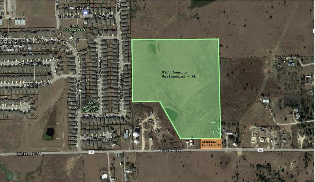
1 NOTICE OF MEETING OF THE PLANNING AND ZONING COMMISSION OF BUDA, TX 7:00 PM - Tuesday, September 26, S. Main Street Buda, TX This notice is posted pursuant to the Texas Open Meetings Act. Notice is hereby given that a Regular Planning & Zoning Meeting of the City of Buda, TX, will be held at which time the following subjects will be discussed and may be acted upon. A. CALL TO ORDER A.1. Signed Agenda B. INVOCATION A PZ Agenda pdf C. PLEDGE OF ALLEGIANCE TO THE FLAGS OF THE UNITED STATES AND TEXAS PLEDGE OF ALLEGIANCE TO THE TEXAS FLAG: Honor the Texas flag; I pledge allegiance to thee, Texas, one state under God, one and indivisible. D. ROLL CALL E. PUBLIC COMMENTS At this time, comments will be take from the audience on non-agenda related topics, for a length of time not to exceed three minutes per person. To address the Planning and Zoning Commission (P&Z), please submit a Citizen's Comment Form to the City Liaison prior to the start of the meeting. No action may be taken by the P&Z during Public Comments. F. PUBLIC HEARINGS F.1. Hold a public hearing to receive written and oral comments in regarding a request to change the zoning from Agricultural (AG) to Arterial Commercial/Offi ce-arterial Retail (C2/R2) for approximately 0.89+/- acres and High Density Residential (HR) for approximately /- acres for the property located along Hillside Terrace approximately 1,500 feet east of Green Meadows Lane on the north side of Hillside Terrace, being /- acres out of George Herder Survey, Hays County, Texas (Z 17-02) G. CONSENT AGENDA G.1. Approval of the regular Planning and Zoning Commission meeting minutes dated September 12, 2017 H. REGULAR AGENDA G1 Minutes from pdf Planning and Zoning Commission Agenda Page 1 September 26,
 for approximately 28.")
2 H.1. Deliberation and possible action in regard to a request to change the zoning from Agricultural (AG) to Arterial Commercial/Offi ce-arterial Retail (C2/R2) for approximately 0.89+/- acres and High Density Residential (HR) for approximately /- acres for the property located along Hillside Terrace approximately 1,500 feet east of Green Meadows Lane on the north side of Hillside Terrace, being /- acres out of George Herder Survey, Hays County, Texas (Z 17-02) H1a SR Z Staff Report.pdf H1b Z Applicant Submission Package.pdf H.2. Deliberation and possible action regarding the final plat of Stonefield Section 12, being acres out of the George Herder Survey, Hays County, Texas and located on Old Goforth Road east of Tom Green School Road (FP 17-13) H2a SR Stonefield 12 final plat.pdf H2b FP _final plat_stonefield 12_ pdf H2c FP 17-13_Stonefield Section 12_U2_BBI Recommend.pdf H2d FP Stonefield Sec Approval Letter.pdf I. STAFF REPORTS J. COMMISSION REQUEST FOR FUTURE AGENDA ITEMS K. ADJOURNMENT City Hall is wheelchair accessible and accessible parking spaces are available. Requests for accommodations must be made 48 hours prior to the meeting. Please contact City Hall at (512) , or FAX (512) for information or assistance. I, the undersigned authority, do hereby certify that the above Notice of Meeting of the Planning and Zoning Commission of the City of Buda, was posted on the bulletin board in front of Buda City Hall, which is readily accessible to the public at all times, by 5:00 pm on DATE, Meetings scheduled in the Council Chambers are set up to publicly broadcast meetings. You may be audio and video recorded while in this facility. Meetings scheduled in other City Facilities are set up to publicly audio record meetings. You may be audio recorded in the other City Facilities. 2 Planning and Zoning Commission Agenda Page 2 September 26, 2017
3 In accordance with Article III, Section 3.10, of the Official Code of the City of Buda, the minutes of this meeting consist of the preceding Minute Record and the Supplemental Minute Record. Details on meetings may be obtained from the Board Liaison, or video of the entire meeting may be downloaded from the website. (Portions of the Supplemental Minute Record video tape recording may be distorted due to equipment malfunction or other uncontrollable factors.) Attendance by Other Elected or Appointed Officials: It is anticipated that members of other governmental bodies, and/or city boards, commissions and/or committees may attend the meeting in numbers that may constitute a quorum of the body, board, commission and/or committee. Notice is hereby given that the meeting, to the extent required by law, is also noticed as a possible meeting of the other body, board, commission and/or committee, whose members may be in attendance, if such numbers constitute a quorum. The members of the boards, commissions and/or committees may be permitted to participate in discussions on the same items listed on the agenda, which occur at the meeting, but no action will be taken by such in attendance unless such item and action is specifically provided for on an agenda for that body, board, commission or committee subject to the Texas Open Meetings Act. 3 Planning and Zoning Commission Agenda Page 3 September 26, 2017
4 4
5 5
6 A. CALL TO ORDER CITY OF BUDA PLANNING AND ZONING COMMISSION MEETING MINUTES SEPTEMBER 12, :00 P.M. Vice-Chair McCarthy called the meeting to order at 7:00 p.m. B. INVOCATION C. PLEDGE OF ALLEGIANCE TO THE FLAGS OF THE UNITED STATES AND TEXAS PLEDGE OF ALLEGIANCE TO THE TEXAS FLAG: Honor the Texas flag; I pledge allegiance to thee, Texas, one state under God, one and indivisible. D. ROLL CALL Commissioner Henry Altmiller Commissioner Angela Britain Commissioner E. Scott Ross Vice-Chair Meghan McCarthy Commissioner Clark Beach Commissioner John Ellis Chair Colin Strother Present Resigned - Relocation Present Present Present Present Absent - Excused E. PUBLIC COMMENTS At this time, comments will be taken from the audience on non-agenda related topics, for a length of time not to exceed three minutes per person. To address the Planning and Zoning Commission, please submit a Citizen Comment Form to the City Liaison prior to the start of the meeting. No action may be taken by the Planning and Zoning Commission during Public Comments No comments were made. F. PUBLIC HEARINGS The Planning & Zoning Commission, meeting as the Capital Improvements Advisory Committee for the purpose of Impact Fee development, and with supplemental member Lori Bible, to consider the following: 1. Hold a public hearing to receive written and oral comments in regard to adoption of a Unified Development Code and Official Zoning Map of the City of Buda to replace the current Unified Development Code and Official Zoning Map. Vice-Chair McCarthy opened the hearing at 7:03 p.m. There being no comments, Vice-Chair McCarthy closed the hearing at 7:03 p.m. G. CONSENT AGENDA 1. Approval of the regular Planning and Zoning Commission meeting minutes dated August 22,
7 Commissioner Altmiller made the motion to approve the consent agenda item, seconded by Commissioner Beach. The motion passed 5-0. H. REGULAR AGENDA ITEMS 1. Introduction and discussion regarding a request to change the zoning from Agricultural (AG) to Arterial Commercial/Office-Arterial Retail (C2/R2) for approximately 0.89+/- acres and High Density Residential (HR) for approximately /- acres for the property located along Hillside Terrace approximately 1,500 feet east of Green Meadows Lane on the north side of Hillside Terrace, being /- acres out of George Herder Survey, Hays County, Texas (Z 17-02). Sparks introduced the item. Applicant Michelle Lynch and Ric Thompson presented. Commissioners asked questions in order to familiarize themselves with the project & property. 2. Deliberation and possible action in regard to adoption of a Unified Development Code and Official Zoning Map of the City of Buda to replace the current Unified Development Code and Official Zoning Map. Sparks introduced the item, outlining changes and affirming comments had been addressed. Sparks indicated the new UDC would be evaluated, with amendments being brought in groups in the future as issues arise. Commissioner Altmiller made the motion, seconded by Commissioner Beach, to recommend approval of the Unified Development Code. The motion passed 5-0. I. STAFF REPORTS The Planning & Zoning Commission may discuss any of the items under Staff Reports, but no formal action will be taken. Update regarding the Unified Development Code Re-Write Update regarding the activities of other city Boards and Commissions, including the Economic Development Corporation Board. Update regarding recent and ongoing Capital Improvements Projects J. COMMISSION REQUESTS FOR FUTURE AGENDA ITEMS No deliberation or discussion may take place by the Commission during this agenda item. K. ADJOURNMENT Commissioner McCarthy made a motion to adjourn the meeting, and a second was made by Commissioner Ross. Upon a unanimous vote and having no further business to consider, Chair Strother adjourned the meeting at 8:10 p.m. ATTEST: Recording Secretary 7
8 Planning & Zoning Commission Agenda Item Report September 26, 2017 Contact David Fowler, AICP, Senior Planner (512) / dfowler@ci.buda.tx.us SUBJECT: DELIBERATION AND POSSIBLE ACTION REGARDING A REQUEST TO CHANGE THE ZONING FROM AGRICULTURAL (AG) TO ARTERIAL COMMERCIAL/OFFICE-ARTERIAL RETAIL (C2/R2) FOR APPROXIMATELY 0.89+/- ACRES AND HIGH DENSITY RESIDENTIAL (HR) FOR APPROXIMATELY /- ACRES FOR THE PROPERTY LOCATED ALONG HILLSIDE TERRACE APPROXIMATELY 1,500 FEET EAST OF GREEN MEADOWS LANE ON THE NORTH SIDE OF HILLSIDE TERRACE, BEING /- ACRES OUT OF GEORGE HERDER SURVEY, HAYS COUNTY, TEXAS (Z 17-02). 1. BACKGROUND This item is the action item pertaining to an application for a rezoning for a /- acre property located immediately east of the Green Meadows Subdivision The request is to change from its initial zoning of AG (assigned upon annexation) to a combination of HR and C2/R2 in order to develop a single-family and townhouse residential project with commercial frontage along Hillside Terrace. The subject property completed annexation in August While the applicant intended to establish this requested zoning at that time, the zoning case was delayed to allow for coordination with the adjacent neighborhood and holding of a neighborhood meeting. As a result, this is being processed as a zoning change from the default zoning category of AG. Surrounding Land Uses Adjacent land uses include: East North West South Outside of City Limits, within ETJ Agricultural property Outside of City Limits, within ETJ Agricultural property HR High Density Residential Existing Green Meadows Subdivision, which has HR zoning (identical to the applicant s request) A portion remains ETJ, which contains a private property as well as a Goforth SUD water facility Outside of City Limits and ETJ Agricultural property with associated homestead 8
9 Unified Development Code Guidance Zoning changes are evaluated based on the following criteria: 1. The zoning change is consistent with the Comprehensive Plan; 2. The zoning change promotes the health, safety, or general welfare of the City and the safe, orderly, and healthful development of the City; 3. The zoning change is compatible with and conforms with uses of nearby property and the character of the neighborhood; 4. The property affected by the zoning change is suitable for uses permitted by the proposed amendment to the zoning map; 5. Infrastructure, including roadway adequacy, sewer, water and storm water facilities, is or is committed to be available that is generally suitable and adequate for the proposed use. 2. FINDINGS/CURRENT ACTIVITY The applicant has included a register of contacts with the neighborhood, as well as a sign in sheet from a neighborhood meeting that took place on July 26, Their report to staff indicates initial skepticism of residents in the neighborhood, but improved understanding once it was made clear that the project was not multifamily and in fact would have the same zoning district designation as Green Meadows. Staff believes confusion is created by the name of the HR zoning district, High Density Residential, because it would conventionally convey high density housing like apartments when instead it is identifying the highest density single-family housing product. This is one of the issues being corrected in the draft UDC. For the public hearing, 41 properties were notified within 200 of the subject property. Staff has not received any responses for or against, but did receive one contact regarding availability of interpretive services (ASL). The following constitutes a preliminary evaluation of the proposed zoning change using the UDC s criteria: 1. The zoning change is consistent with the Comprehensive Plan; Pertinent excerpts from the Buda 2030 Comprehensive Plan as well as the Future Land Development Plan contained within it are attached. This property is within the Emerging Growth District and on the fringe of a Community Mixed Use Node according to the Future Land Use Character Districts. HR zoning is considered appropriate in this area. C2/R2 zoning is considered conditionally appropriate. In this case, the area being designated C2/R2 is along Hillside Terrace, which is an arterial thoroughfare. Hillside Terrace is planned for improvements as part of Hays County s recently approved road bonds. Based on information from the comprehensive plan and surrounding uses, approval of this zoning change would NOT constitute spot zoning, as it could be considered consistent with the Comprehensive Plan. Spot zoning is the application of zoning to a specific parcel or parcels of land within a larger zoned area when the rezoning is usually at odds with a city's master plan and current zoning restrictions, and appears wholly outof-place in comparison to surrounding zoning. 2. The zoning change promotes the health, safety, or general welfare of the City and the safe, orderly, and healthful development of the City; Staff has not identified critical issues with the potential uses in the HR and C2/R2 district that would negatively affect the health, safety or general welfare of the City and the safe, orderly and healthful development of the City. 3. The zoning change is compatible with and conforms with uses of nearby property and the character of the neighborhood; The surrounding properties are expected to develop at some point in the future, likely in a primarily residential manner with neighborhood-supporting commercial. The adjacent 9
10 neighborhood carries identical HR zoning to the proposed residential portions of the subject property. 4. The property affected by the zoning change is suitable for uses permitted by the proposed amendment to the zoning map; The subject property does have some significant topography, particularly along the northern portions of the site. Two ponds are present on the property, as well as a small wetlands corridor. The property drains toward the north and northeast. There are very few trees on the site, with none appearing to reach heritage size based on a staff visit to the property. For any development on this property, the applicant will be required to comply with applicable development standards such as maximum impervious cover, water detention/quality, and site/building design, pursuant to the Unified Development Code. The applicant intends to pursue three residential types: Traditional Single-Family Detached with Fee-Simple Ownership Single-Family Detached with Condominium Ownership o The only reason for this is to address the need for private sewer pumping to overcome some topographic challenges; it will look, feel & function like any other single-family detached neighborhood Single-Family Attached Townhomes with Fee-Simple Ownership The C2/R2 area at the front will potentially involve an amenity center integrated with some neighborhood-serving commercial lease space. The applicant, as well as staff, have determined this project to be consistent with these property characteristics, using the combination of HR with a small C2/R2 area is feasible given constraints. 5. Infrastructure, including roadway adequacy, sewer, water and storm water facilities, is or is committed to be available that is generally suitable and adequate for the proposed use. 3. FINANCIAL IMPACT N/A This zoning change does not negatively affect infrastructure capacity or adequacy. The property, through annexation, falls within the City of Buda wastewater service area, though it is technically not within any defined CCN boundary. The City of Buda has anticipated development of this property as part of its water and wastewater models. The applicant, as with any developer, is responsible for construction of their infrastructure improvements as well as any off-site improvements caused by the project. A Traffic Impact Analysis is being performed in association with the project s preliminary plan, which will come to the Commission for approval. Hillside Terrace is planned for improvements as part of Hays County s recently approved road bonds. 4. RECOMMENDATION Staff recommends the City Council consider recommending approval of the zoning request. 5. ATTACHMENTS Applicant Package (includes relevant maps) 10
11 September 1, 2017 Mr. Chance Sparks, Director Planning and Engineering Department 100 Houston Street, Suite A Buda, Texas Via Electronic Transmission Re: Application for Rezoning; acres located at 1400 Hillside Terrace (the Property ) Dear Mr. Sparks: As representatives of the owner of the above stated Property we respectfully submit the attached Application for Rezoning. The Property is located at 1400 Hillside Terrace (see Location Map attached) and was recently annexed and on August 15, The Application for Rezoning requests to rezone: (i) a portion of the Property to High Density Residential (HR), to allow for 52 single family detached (fee simple) lots, 26 single family detached (condo regime) units, and 49 single family attached units, and (ii) a portion of the Property to Arterial Retail (R2) for an approximately 10,000 square foot office/retail development (as shown on the attached Zoning Map) ( Project ). The Property is currently undeveloped today. In the Comprehensive Plan, the Property is in the Emerging Growth District and on the edge of a Community Node. High Density Residential is shown as an appropriate zoning district in an Emerging Growth District. Although Arterial Retail is shown as a conditional zoning district in the Emerging Growth District, there is existing Arterial Retail zoning nearby and previous discussions with you have confirmed that this location is suitable for Arterial Retail zoning. Therefore, the requested zoning change is compatible with the Comprehensive Plan. The existing neighborhood to the west (Green Meadows) is zoned High Density Residential (HR), the same zoning category that is requested for the Property. Furthermore, as the distance from Green Meadows increases, so does the density of the proposed development on the Property. A portion of Green Meadows along Hillside Terrace is also zoned Arterial Retail, the same zoning category being requested for the Property along Hillside Terrace. Therefore, the zoning change for the Property is compatible with and conforms to the uses and zoning of the nearby property. The Property was annexed to utilize the City s water and sewer infrastructure. The engineer for the Project, Ric Thompson, has been in discussions with City staff regarding other infrastructure requirements for the Project and we are unaware of any infrastructure issues at this time. A Traffic Impact Analysis is being prepared for the Project in association with the pending preliminary plan in review and will assess impacts on nearby roadways and intersections. 11
12 Mr. Chance Sparks September 1, 2017 Page 2 We are unaware of any variances that will be needed, with the requested zoning change. If you have any questions about this Application for Rezoning or need additional information, please do not hesitate to contact me at your convenience. Thank you for your time and attention to this project. Very truly yours, Michele Rogerson Lynch cc: Mark Yu Sun, (Owner, markyusun@gmail.com) Fiona Feng (SunLion Real Estate (suncapital.fiona@gmail.com) Yi-Chieh Lo (SunLion Real Estate, suncapital.ej@gmail.com) Ric Thompson (Thompson Land Engineering, ric@tleng.net) Joe Ternus-Dolores (Traffic Engineer, dajst@earthlink.net) Will Herring (Metcalfe, Wolff, Stuart & Williams, LLP, wherring@mwswtexas.com) 12

13 Mr. Chance Sparks September 1, 2017 Page 3 Location Map 13

14 Mr. Chance Sparks September 1, 2017 Page 4 14

15 Mr. Chance Sparks September 1, 2017 Page 5 Zoning Map 15

16 16
17 17
18 18

19 19
20 Texas SunHomes at Hillside Creek Neighborhood Contact 5/8/17 correspondence with Shannon Viscardi 5/12/17 correspondence with Stacey Magnesio 5/19/17 exchange with Tammy Hernandez 5/26/17 teleconference with Matt Debow 7/26/17 meeting with Green Meadows neighbors 7/28/17 correspondence with Shannon Viscardi 20

21 21
22 FLUGEL LAND SURVEYING PROFESSIONAL LAND SURVEYORS Firm No EXHIBIT LEGAL DESCRIPTION FOR A ACRE TRACT LEGAL DESCRIPTION OF A ACRE TRACT OR PARCEL OF LAND, BEING A PORTION OF ACRES (CALLED ACRES) OUT OF THE GEORGE HERDER SURVEY, ABSTRACT NO. 239, HAVING BEEN CONVEYED TO SUNLION REAL ESTATE, LLC, IN DOCUMENT # , OFFICIAL PUBLIC RECORDS, HAYS COUNTY, TEXAS; SAID ACRE TRACT OR PARCEL BEING MORE PARTICULARLY DESCRIBED BY METES AND BOUNDS AS FOLLOWS: BEGINNING at a ½ iron rod found on the north right+of+way (R.O.W) line of Hillside Terrace (R.O.W. varies) being the southwest corner of a called acre tract conveyed to Brenda Taylor (formerly Brenda A. Bailey) in Volume 4868, Page 782, Official Public Records, Hays County, Texas, the southeast corner of said acre tract, and the southeast corner and POINT OF BEGINNING of the herein described tract; THENCE, S W along the north R.O.W. line of said Hillside Terrace a distance of to a capped ½ iron rod found stamped Byrn Survey being the southeast corner of a called 0.52 acre tract conveyed to Goforth Special Utility District in Volume 3348, Page 190, Deed Records, Hays County, Texas, also recorded in Document # , Official Public Records, Hays County, Texas, a southwest corner of said acre tract, and the southwest corner of the herein described tract; THENCE, N W along the east line of said called 0.52 acre tract a distance of to a capped ½ iron rod found stamped Byrn Survey being the northeast corner of said called 0.52 acre tract, an interior corner of said acre tract, and the northwest corner of the herein described tract; THENCE, through and across said acre tract N E a distance of to a calculated point on the west line of said called acre tract and the east line of said acre tract for the northeast corner of the herein described tract; THENCE, S E along the west line of said called acre tract and the east line of said acre tract a distance of to the POINT OF BEGINNING and containing acres of land, more or less. BASIS OF BEARINGS: Bearings are based on NAD 83 State Plane Coordinates. (Texas Central 4203) 2007 S 1 st St, Suite 103 Page 1 of 4 Austin, Tx (512)
23 I do hereby certify that this description is true and correct to the best of my knowledge and belief, and was prepared from an actual on the ground survey under my supervision, and that the markers described herein actually exist, as described, at the time of my survey. As Prepared by Flugel Land Surveying Firm Registration No Paul J. Flugel Date of Survey: 10/25/2016 RPLS No Date of Field Notes: 9/5/2017 Page 2 of 4 23
24 FEATHERGRASS DRIVE (50' R.O.W.) FINAL PLAT, GREEN MEADOWS SECTION 2A, VOL. 13, PG. 300, P.R.H.C.T. (801.24') (N0 00' 00"E) (S0 03' 34"W) ( ') SURVEY OF ACRES, BEING A PORTION OF ACRES (CALLED ACRES) OUT OF THE GEORGE HERDER SURVEY, ABSTRACT NO. 239, HAVING BEEN CONVEYED TO SUNLION REAL ESTATE, LLC, IN DOCUMENT # , OFFICIAL PUBLIC RECORDS, HAYS COUNTY, TEXAS LILLIE D. RAY & GLORIA CAVNESS VOL. 2080, PG. 653 D.R.H.C.T. ( ACRES) JECULIN SUE OLIVER SMITH VOL. 371, PG. 820 D.R.H.C.T. (20.00 ACRES) Feet ( ') (S89 44' 27"E) (S89 33' 40"W) (359.12') S1 35' 27"E ' MARK ENDICOTT VOL. 305, PG. 756 D.R.H.C.T. ( ACRES) (6.109 ACRES) GARY LEE GRIFFIN VOL. 4041, PG. 672 D.R.H.C.T. & DOC. # O.P.R.H.C.T. (N26 42' 10"W) (569.81') (S1 04' 12"E) BRENDA TAYLOR VOL. 4868, PG. 782 O.P.R.H.C.T. (234.95') (1.553 ACRES) FLUGEL LAND SURVEYING FIRM NO (0.52 ACRES) GOFORTH SPECIAL UTILITY DISTRICT VOL. 3348, PG. 190, D.R.H.C.T. & DOC. # , O.P.R.H.C.T. HILLSIDE TERRACE (R.O.W. VARIES) POINT OF BEGINNING PROPOSED R2 ZONING TRACT ACRES FIRM # F S 1 ST STREET, SUITE 103 AUSTIN, TEXAS (512) SHEET OF 4 24
25 SURVEY OF ACRES, BEING A PORTION OF ACRES (CALLED ACRES) OUT OF THE GEORGE HERDER SURVEY, ABSTRACT NO. 239, HAVING BEEN CONVEYED TO SUNLION REAL ESTATE, LLC, IN DOCUMENT # , OFFICIAL PUBLIC RECORDS, HAYS COUNTY, TEXAS LINE TABLE LINE # L1 DIRECTION N88 12' 14"W (N83 02' 46"W) LENGTH 1.98' (2.01') LEGEND 1/2" IRON ROD FOUND L2 S2 44' 35"E 69.86' 4"x4" CONCRETE MONUMENT (S1 04' 12"E) (69.92') 2.5" IRON BOLT FOUND L3 S87 15' 25"W (S88 55' 48"W) 2.69' (2.69') 1/2" IRON ROD SET STAMPED "P FLUGEL 5096" L4 S2 44' 35"E 23.22' CALCULATED POINT (S1 04' 12"E) (23.24') R.O.W. RIGHT-OF-WAY L5 N87 15' 25"E 1.15' ( ) RECORD INFORMATION L6 (N88 55' 48"E) S2 44' 35"E (1.15') ' P.R.H.C.T. PLAT RECORDS, HAYS COUNTY, TEXAS L7 S87 38' 16"W (S89 17' 36"W) ' (315.53') D.R.H.C.T. DEED RECORDS, HAYS COUNTY, TEXAS L8 N1 16' 35"W (N0 22' 35"E) ' (123.98') O.P.R.T.C.T. OFFICIAL PUBLIC RECORDS, HAYS COUNTY, TEXAS L9 N87 38' 16"E ' HORIZONTAL DATUM: L10 L11 S2 44' 35"E S88 43' 25"W ' ' TEXAS STATE PLANE COORDINATES NAD '83 (SOUTH CENTRAL ZONE 4204) (N89 36' 26"W) (213.37') FLUGEL LAND SURVEYING FIRM NO FIRM # F S 1 ST STREET, SUITE 103 AUSTIN, TEXAS (512) SHEET OF 4 25
 OUT OF THE GEORGE HERDER SURVEY, ABSTRACT NO.")
26 FLUGEL LAND SURVEYING PROFESSIONAL LAND SURVEYORS Firm No EXHIBIT LEGAL DESCRIPTION FOR A ACRE TRACT LEGAL DESCRIPTION OF A ACRE TRACT OR PARCEL OF LAND, BEING A PORTION OF ACRES (CALLED ACRES) OUT OF THE GEORGE HERDER SURVEY, ABSTRACT NO. 239, HAVING BEEN CONVEYED TO SUNLION REAL ESTATE, LLC, IN DOCUMENT # , OFFICIAL PUBLIC RECORDS, HAYS COUNTY, TEXAS; SAID ACRE TRACT OR PARCEL BEING MORE PARTICULARLY DESCRIBED BY METES AND BOUNDS AS FOLLOWS: BEGINNING at a ½ iron rod found for the POINT OF REFERENCE on the north right+of+way (R.O.W) line of Hillside Terrace (R.O.W. varies) being the southwest corner of a called acre tract conveyed to Brenda Taylor (formerly Brenda A. Bailey) in Volume 4868, Page 782, Official Public Records, Hays County, Texas, and the southeast corner of said acre tract; THENCE, N W a distance of to a calculated point on the east line of said acre tract and the west line of said called acre tract being the southeast corner and POINT OF BEGINNING of the herein described tract; THENCE, through and across said acre tract S W a distance of to a capped ½ iron rod found stamped Byrn Survey being the northeast corner of a called 0.52 acre tract conveyed to Goforth Special Utility District in Volume 3348, Page 190, Deed Records, Hays County, Texas, also recorded in Document # , Official Public Records, Hays County, Texas, an interior corner of said acre tract, and an angle point on the south line of the herein described tract; THENCE, S W along the north line of said called 0.52 acre tract a distance of to a capped ½ iron rod found stamped Byrn Survey on the east line of a called acre tract conveyed to Gary Lee Griffin in Volume 4041, Page 672, Deed Records, Hays County, Texas, also recorded in Document # , Official Public Records, Hays County, Texas, being the northwest corner of said called 0.52 acre tract, a southwest corner of said acre tract, and a southwest corner of the herein described tract; THENCE, N W along the east line of said called acre tract a distance of to a ½ iron rod found being the northeast corner of said called acre tract, an interior corner of said acre tract, and an interior corner of the herein described tract; THENCE, S W along the north line of said called acre tract a distance of to a ½ iron rod found on the east line of Lot 10, Final Plat, Green Meadows Section 2A, recorded in Volume 13, Page 300, Plat Records, Hays County, Texas, being a southwest corner of said acre tract, and a southwest corner of the herein described tract; THENCE, N W along the east line of said Final Plat, Green Meadows Section 2A, a distance of to a capped ½ iron rod found stamped RDS on the east line of Lot 12, of said Final Plat, Green Meadows Section 2A, being the southwest corner of a called acre tract conveyed to Lillie D. Ray & Gloria Cavness in Volume 2080, Page 653, Deed Records, Hays County, Texas, the northwest corner of said acre tract, and the northwest corner of the herein described tract; THENCE, N E along the south line of said called acre tract a distance of to a calculated point, from which a found ½ iron rod bears 2.40 north, for the southeast corner of said called acre tract and the southwest corner of a called acre tract conveyed to Jaculin Sue Oliver Smith in Volume 371, Page 820, Deed Records, Hays County, Texas, and continuing for a 2007 S 1 st St, Suite 103 Page 1 of 5 Austin, Tx (512)
27 total distance of to the top of a 2 ½ iron rod found, protruding 2 up from the ground, being and interior corner of said called acre tract, the northeast corner of said acre tract, and the northeast corner of the herein described tract; THENCE, S E along the west line of said called acre tract and a called acre tract conveyed to Mark Endicott in Volume 305, Page 756, Deed Records, Hays County, Texas, a distance of to a 4 x4 concrete monument found on the north line of said called acre tract being the southwest corner of said called acre tract and a jog in the east line of said acre tract and the herein described tract; THENCE, N W along the north line of said called acre tract a distance of 1.98 to a ½ iron rod found being the northwest corner of said called acre tract and a point on the east line of said acre tract and the herein described tract; THENCE, S E a distance of to a ½ iron rod set with a cap stamped P Flugel 5096 at a jog in the west line of said called acre tract and the east line of said acre tract and the herein described tract; THENCE, S W a distance of 2.69 to a ½ iron rod set with a cap stamped P Flugel 5096 on the west line of said called acre tract and the east line of said acre tract and the herein described tract; THENCE, S E a distance of to a ½ iron rod set with a cap stamped P Flugel 5096 at a jog in the west line of said called acre tract and the east line of said acre tract and the herein described tract; THENCE, N E a distance of 1.15 to a calculated point on the west line of said called acre tract and the east line of said acre tract and the herein described tract; THENCE, S E along the west line of said called acre tract and the east line of said acre tract a distance of to the POINT OF BEGINNING and containing acres of land, more or less. BASIS OF BEARINGS: Bearings are based on NAD 83 State Plane Coordinates. (Texas Central 4203) Page 2 of 5 27

28 I do hereby certify that this description is true and correct to the best of my knowledge and belief, and was prepared from an actual on the ground survey under my supervision, and that the markers described herein actually exist, as described, at the time of my survey. As Prepared by Flugel Land Surveying Firm Registration No Paul J. Flugel Date of Survey: 10/25/2016 RPLS No Date of Field Notes: 9/5/ Page 3 of 5
29 FEATHERGRASS DRIVE (50' R.O.W.) FINAL PLAT, GREEN MEADOWS SECTION 2A, VOL. 13, PG. 300, P.R.H.C.T. (801.24') (N0 00' 00"E) (S0 03' 34"W) ( ') SURVEY OF ACRES, BEING A PORTION OF ACRES (CALLED ACRES) OUT OF THE GEORGE HERDER SURVEY, ABSTRACT NO. 239, HAVING BEEN CONVEYED TO SUNLION REAL ESTATE, LLC, IN DOCUMENT # , OFFICIAL PUBLIC RECORDS, HAYS COUNTY, TEXAS LILLIE D. RAY & GLORIA CAVNESS VOL. 2080, PG. 653 D.R.H.C.T. ( ACRES) JECULIN SUE OLIVER SMITH VOL. 371, PG. 820 D.R.H.C.T. (20.00 ACRES) Feet ( ') (S89 44' 27"E) (S89 33' 40"W) (359.12') S1 35' 27"E ' MARK ENDICOTT VOL. 305, PG. 756 D.R.H.C.T. ( ACRES) (6.109 ACRES) GARY LEE GRIFFIN VOL. 4041, PG. 672 D.R.H.C.T. & DOC. # O.P.R.H.C.T. (N26 42' 10"W) (569.81') BRENDA TAYLOR VOL. 4868, PG. 782 O.P.R.H.C.T. (1.553 ACRES) FLUGEL LAND SURVEYING FIRM NO (0.52 ACRES) GOFORTH SPECIAL UTILITY DISTRICT VOL. 3348, PG. 190, D.R.H.C.T. & DOC. # , O.P.R.H.C.T. HILLSIDE TERRACE (R.O.W. VARIES) POINT OF REFERENCE PROPOSED HR ZONING TRACT ( ACRES) FIRM # F S 1 ST STREET, SUITE 103 AUSTIN, TEXAS (512) SHEET OF 5 29

30 SURVEY OF ACRES, BEING A PORTION OF ACRES (CALLED ACRES) OUT OF THE GEORGE HERDER SURVEY, ABSTRACT NO. 239, HAVING BEEN CONVEYED TO SUNLION REAL ESTATE, LLC, IN DOCUMENT # , OFFICIAL PUBLIC RECORDS, HAYS COUNTY, TEXAS LINE TABLE LINE # DIRECTION LENGTH L1 N88 12' 14"W 1.98' LEGEND (N83 02' 46"W) (2.01') 1/2" IRON ROD FOUND L2 L3 S2 44' 35"E (S1 04' 12"E) S87 15' 25"W (S88 55' 48"W) 69.86' (69.92') 2.69' (2.69') 4"x4" CONCRETE MONUMENT 2.5" IRON BOLT FOUND 1/2" IRON ROD SET STAMPED "P FLUGEL 5096" L4 L5 S2 44' 35"E (S1 04' 12"E) N87 15' 25"E 23.22' (23.24') 1.15' R.O.W. CALCULATED POINT RIGHT-OF-WAY (N88 55' 48"E) (1.15') ( ) RECORD INFORMATION L6 L7 S2 44' 35"E S87 38' 16"W (S89 17' 36"W) ' ' (315.53') P.R.H.C.T. D.R.H.C.T. PLAT RECORDS, HAYS COUNTY, TEXAS DEED RECORDS, HAYS COUNTY, TEXAS L8 N1 16' 35"W (N0 22' 35"E) ' (123.98') O.P.R.T.C.T. OFFICIAL PUBLIC RECORDS, HAYS COUNTY, TEXAS L9 S87 38' 16"W ' HORIZONTAL DATUM: L10 L11 S2 44' 35"E S88 43' 25"W ' ' TEXAS STATE PLANE COORDINATES NAD '83 (SOUTH CENTRAL ZONE 4204) (N89 36' 26"W) (213.37') FLUGEL LAND SURVEYING FIRM NO FIRM # F S 1 ST STREET, SUITE 103 AUSTIN, TEXAS (512) SHEET OF 5 30
31 Planning and Zoning Commission Agenda Item Report September 26, 2017 Contact Chance Sparks, AICP, CNUa, Director of Planning / csparks@ci.buda.tx.us SUBJECT: DELIBERATION AND POSSIBLE ACTION ON THE FINAL PLAT OF STONEFIELD SUBDIVISION SECTION 12, BEING ACRES OF LAND OUT OF THE GEORGE HERDER SURVEY NO. 537, ABSTRACT NO 239, SITUATED IN THE CITY OF BUDA ETJ, AND LOCATED ALONG OLD GOFORTH ROAD IMMEDIATELY SOUTH OF THE STONEFIELD SUBDIVISION, SECTION BACKGROUND/HISTORY The preliminary plan for Stonefield was originally approved in the fall of 2005 and was originally referred to as the Horton Tract. It was last revised in October 2012 in order to create an amenity center. The Preliminary Plan approval included a variance allowing the development a maximum of 18 lots on a single block face rather than 12, as well as variances regarding interior angle of eyebrows (corner cul-de-sacs). Sections 1-11 have been platted. Section 12 is the final section of Stonefield. 2. FINDINGS/CURRENT ACTIVITY The Section 12 final plat encompasses 60 single-family residential lots and 4 open space lots within acres. The plat is adjacent to Stonefield Sections Six and Eleven and is across Old Goforth Road from Tom Green Elementary School. With this plat, Calomel Trail will connect to Jasper Trail via routes other than Tanzanite Circle. No parkland is dedicated in this section; however this plat abuts the park that was dedicated in Section 11. The City of Buda provides wastewater service to the subdivision via the South Buda Water Control & Improvement District. Goforth Special Utility District provides water service, also via the South Buda Water Control and Improvement District. The property is located in the ETJ due to the South Buda Water Control and Improvement District. 3. FINANCIAL IMPACT Parkland fees are assessed at $ per lot, which totals $47, for this plat. 4. ACTION OPTIONS/RECOMMENDATION Assessment by staff indicates all applicable requirements of the Unified Development Code and Development Agreement have been satisfied. Payment of any required parkland fees will be made prior to recording of the plat. Staff recommends approval of the final plat of Stonefield Subdivision, Section ATTACHMENTS Final Plat Illustrative Master Plan for Section Location Reference 31
32 L ' 35.85' ' 56.00' 52.00' 53.39' ' 52.00' Y U DENISE ELLEN 11 LOVE L N 16 OLD GOFORTH CITY LIMIT ' 19 L3 L L6 (50' R.O.W) ' M L10 L11 C3 L GRAPHIC SCALE STONEFIELD SECTION TWELVE ACRES OF LAND OUT OF THE GEORGE HERDER SURVEY NO. 537, ABSTRACT NO. 239, SITUATED IN THE CITY OF BUDA ETJ, HAYS COUNTY, TEXAS OPR ( IN FEET ) 1 inch = 100 ft. ½" IRON ROD FOUND (UNLESS STATED) ½" IRON ROD W/CAP SET STAMPED "CUNNINGHAM ALLEN INC." B.L. BUILDING LINE "CAI" CUNNINGHAM ALLEN INC P.U.E. PUBLIC UTILITY EASEMENT R.O.W. RIGHT-OF-WAY PR DR VOL. VOLUME PG. PAGE D.E. OFFICIAL PUBLIC RECORDS OF HAYS COUNTY, TEXAS PLAT RECORDS OF HAYS COUNTY, TEXAS DEED RECORDS OF HAYS COUNTY, TEXAS WWE WASTEWATER EASEMENT O/L IRON PIPE FOUND DRAINAGE EASEMENT PROPOSED SIDEWALK BENCHMARK LOCATION MAP (NOT TO SCALE) OPEN SPACE AND LANDSCAPE LOT HILLSIDE KNOX HILLSIDE TERRACE CITY LIMITS CITY LIMITS CITY LIMITS BUDA TEXAS HAYS COUNTY # SITE # #3 BENCHMARK INFORMATION NGS MONUMENT "V-1305" N= E= ELEV. = ' (NAVD88) TEXAS COORDINATE SYSTEM OF 1983, SOUTH CENTRAL ZONE ENGINEER: CUNNINGHAM-ALLEN, INC BEE CAVE ROAD, SUITE 202 AUSTIN, TX SURVEYOR: CUNNINGHAM-ALLEN, INC BEE CAVE ROAD, SUITE 202 AUSTIN, TX PLANNER: TGB, INC POST OAK BLVD. HOUSTON, TX TOTAL AREA: ACRES NUMBER OF LOTS: AVERAGE LOT SIZE SINGLE FAMILY (LOTS LESS THAN 1 ACRE) ACRES 0.15 ACRES R.O.W. DEDICATION: ACRES PARK DEDICATION: 0 OPEN SPACE & LANDSCAPE: ACRES TOTAL ACRES TOTAL NUMBER OF BLOCKS: 3 SURVEY: GEORGE HERDER SURVEY NO. 537, ABSTRACT NO. 239 OWNER: LENNAR HOMES OF TEXAS LAND AND CONSTRUCTION, LTD RESEARCH BOULEVARD, BLDG. 4, SUITE 450 AUSTIN, TX SUBDIVIDER/DEVELOPER: LENNAR HOMES OF TEXAS LAND AND CONSTRUCTION, LTD RESEARCH BOULEVARD, BLDG. 4, SUITE 450 AUSTIN, TX BY: SCOTT TEETER STREET DEDICATION: 2,029 LF L18 2,738.17' (GRID) S69 51'27"W 57.36' 25.85' 24.31' 51.91' 70 PEDESTRIAN PATH ' C33 C20 C ' 55.00' 55.00' 55.00' 59.82' 51.68' 49.80' S01 56'06"E O/L O/L C30 C31 C30 C29 C11 C29 O/L L ' ' ' N01 47'34"W 90.28' 72.29' 95.99' S01 56'06"E ' 57.00' C10 C12 N67 36'02"W C ' 86.33' 52.00' 50.61' 44.63' C8 C ' C2 L21 C1 C4 C ' L ' C ' 53.25' S88 03'54"W S88 03'54"W 52.37' 44.95' ' S88 12'26"W 77.37' 69.95' S01 47'34"E S01 47'34"E 45.24' 94.94' 52.00' 53.39' 50.61' 51.00' 95.00' L ' 69.39' 53.00' ' N88 03'54"E 53.00' 23.08' 55.00' 55.00' 49.73' 95.06' 94.94' ' 53.00' N88 03'54"E N88 03'54"E 53.00' 46.16' 44.76' 51.00' 53.00' 53.00' 53.00' 53.00' 53.00' 42.70' N88 03'54"E 70.00' 51.00' 53.00' 53.00' 53.00' 53.00' 53.00' 63.44' N88 03'54"E 114 O/L N88 03'54"E N88 03'54"E STONEFIELD SECTION NINE VOL. 17, PG. 217, PR C26 C27 STONEFIELD SECTION SIX VOL. 16, PG. 340, PR CITY LIMITS LANDSCAPE WATER LINE EASEMENT GOFORTH WATER SUPPLY CORPORATION VOL PG. 769 O.P.R.H.C.T. & WATER LINE EASEMENT GOFORTH WATER SUPPLY CORPORATION VOL PG. 850 O.P.R.H.C.T. Y (50' R.O.W) R50' EMERALD GREEN TRAIL TEMPORARY PUBLIC UTILITY EASEMENT DOC. NO , OPR VOL. 19, PG. 107, PR STONEFIELD SECTION TEN ADOQUIN TRAIL (50' R.O.W) TANZANITE CIRCLE TANZANITE CIRCLE (50' R.O.W) STONEFIELD SECTION ELEVEN DOC. NO , OPR TEMPORARY PUBLIC UTILITY EASEMENT DOC. NO , OPR TEMPORARY P.U.E VOL. 4436, PG. 54, OPR TEMPORARY WATERLINE EASEMENT VOL.4817, PG.445, OPR L4 TEMPORARY ACCESS VOL.4220, PG. 529, OPR EASEMENT L2 JASPER TRAIL L8 N88 12'26"E ' N88 12'26"E ' L= ' N01 47'34"W 97.32' TEMPORARY ' MOON STONE TRAIL (50' R.O.W) 64.05' L22 L23 EMERALD GREEN TRAIL (50' R.O.W) TEMPORARY PUBLIC UTILITY EASEMENT DOC. NO , OPR C28 (60' R.O.W) C15 WATER LINE EASEMENT GOFORTH WATER SUPPLY CORPORATION VOL PG. 769 O.P.R.H.C.T. & WATER LINE EASEMENT GOFORTH WATER SUPPLY CORPORATION VOL PG. 850 O.P.R.H.C.T. L PUBLIC UTILITY EASEMENT DOC. NO , OPR COUNTY ROAD 119 (OLD GOFORTH ROAD) N88 12'26"E ' N: E: ' S88 12'26"W ' L5 L7 C ' ' C18 N88 12'26"E N88 12'26"E ' 21 O/L ' C19 L = ' S01 56'06"E ' N01 56'06"W ' S01 56'06"E ' N01 56'06"W ' S 01 56'06" E S01 56'06"E ' N01 56'06"W ' S01 56'06"E ' N01 56'06"W ' ' ' L12 N81 39'12"E ' L13 L15 CALOMEL TRAIL STONEFIELD SECTION ELEVEN DOC. NO , OPR (50' R.O.W) TANZANITE CIRCLE LENNAR HOMES OF TEXAS LAND & CONSTRUCTION, LTD., VOL. 3405, PG. 655, OPR ETJ CITY LIMITS TEMPORARY PUBLIC UTILITY EASEMENT DOC. NO , OPR N: E: HAYS COUNTY INDEPENDENT SCHOOL DISTRICT GREEN MEADOWS HOMEOWNERS ASSOCIATION INC GREEN CORNERS LLC ACRES HEREBY DEDICATED RIGHT-OF-WAY C17 C25 C24 S88 12'26"W C32 L9 C21 S88 03'54"W C22 C23 CITY OF BUDA TBM# 3 N: E: TANZANITE CIRCLE ' M DETAIL LOT 21, BLOCK M SUBMITTAL DATE: Cunningham Allen 3103 Bee Cave Road, Suite 202 Tel.: (512) Austin, Texas Fax: (512) Firm Registration: TBPE# F-284; TBPLS# DATE: 02/2017 PROJECT NO.: Engineers Surveyors Drawing Path: S:\ _Stonefield 12\_Drawings\ _Final Plat_Stonefield 12.dwg Plotted By: Jason Johnson Date: 8/1/2017 4:48:22 PM Layout: SEC 12 SHT 1 COPYRIGHT 2017 CUNNINGHAM-ALLEN, INC. DRAWN BY: JJ SHEET 1 OF 3 APRIL 04, 2017 L25 C14 C16 ETJ
33 33 STONEFIELD SECTION TWELVE ACRES OF LAND OUT OF THE GEORGE HERDER SURVEY NO. 537, ABSTRACT NO. 239, SITUATED IN THE CITY OF BUDA ETJ, HAYS COUNTY, TEXAS LINE TABLE CURVE TABLE LINE L1 L2 L3 L4 L5 L6 L7 L8 L9 L10 L11 L12 L13 L14 L15 L16 L17 L18 L19 L20 L21 L22 L23 L24 BEARING S88 03'54"W N01 56'06"W S88 12'26"W S81 48'00"W N01 47'34"W S88 12'26"W N01 47'34"W N01 47'34"W N01 47'34"W N88 03'54"E N88 05'23"E N76 35'58"E N80 29'50"E N88 03'54"E N88 03'54"E S88 03'54"W S88 03'54"W N01 47'34"W N88 12'26"E N88 00'23"E N84 26'04"E N81 39'12"E N81 39'12"E S01 56'05"E DISTANCE 30.00' 26.64' ' 83.21' 57.00' 47.29' 26.24' 51.02' 50.44' 64.16' 10.00' 10.00' 20.00' 27.32' 12.36' ' ' ' ' 0.80' L25 S39 00'42"E 15.70' CURVE C1 C2 C3 C4 C5 C6 C7 C8 C9 C10 C11 C12 C13 C14 C15 C16 C17 C18 C19 C20 C21 C22 C23 C24 C25 C26 C27 C28 C29 RADIUS ' ' ' LENGTH 29.02' 10.26' ' 11.49' 29.76' 21.03' 8.30' 45.37' 35.00' 52.04' 5.99' 15.04' 39.27' 38.71' 26.41' 39.27' 39.33' 39.27' 39.27' 21.03' 71.19' 17.04' 21.03' 39.33' 39.21' 28.98' 7.49' 2.08' 42.02' DELTA 66 30'18" 23 31'10" 4 34'14" 26 20'30" 68 12'16" 48 11'23" 9 30'28" 51 59'27" 40 06'25" 59 38'06" 13 43'15" 34 28'08" 90 00'00" 88 42'24" 1 17'36" 90 00'00" 90 08'32" 90 00'00" 90 00'00" 48 11'23" 81 34'58'' 19 31'49" 48 11'23" 90 08'32" 89 51'28" 66 25'19" 17 09'59" 0 06'07" 96 18'35" CHORD BRG. S54 50'14"W S09 49'29"W N85 48'16"E N15 06'21"W N62 22'43"W S26 01'47"E S45 22'14"E S14 37'17"E S31 25'39"W N73 25'14"W N50 27'48"W N74 33'30"W S43 12'26"W S42 25'07"W S87 25'07"W N46 56'06"W S43 08'10"W N46 47'34"W N43 12'26"E S67 41'52"E N10 11'49"E N40 21'34"W N26 01'47"W S43 08'10"W N46 51'50"W S48 26'33"W S06 38'54"W N81 42'16"E S50 05'23"E CHORD 27.42' 10.19' ' 11.39' 28.03' 20.41' 8.29' 43.83' 34.29' 49.72' 5.97' 14.81' 35.36' 34.95' 26.41' 35.36' 35.40' 35.36' 35.36' 20.41' 65.33' 16.96' 20.41' 35.40' 35.31' 27.39' 7.46' 2.08' 37.25' Parcel Area Table LOT NO. ACREAGE BLOCK "M" Parcel Area Table LOT NO. ACREAGE BLOCK "L" Parcel Area Table LOT NO. ACREAGE BLOCK "Y" C ' 66 22'22" N65 04'35"W 27.34' C ' 90 08'32" N43 08'10"E 35.40' C ' 85 24'31" S86 18'26"E 67.82' C ' 25 16'50" S64 07'18"W 21.88' SUBMITTAL DATE: APRIL 04, 2017 Cunningham Allen 3103 Bee Cave Road, Suite 202 Tel.: (512) Austin, Texas Fax: (512) Firm Registration: TBPE# F-284; TBPLS# DATE: 02/2017 PROJECT NO.: Engineers Surveyors Drawing Path: S:\ _Stonefield 12\_Drawings\ _Final Plat_Stonefield 12.dwg Plotted By: Jason Johnson Date: 8/1/2017 4:48:47 PM Layout: SEC 12 SHT 2 COPYRIGHT 2017 CUNNINGHAM-ALLEN, INC. DRAWN BY: JJ SHEET 2 OF 3
34 34 STONEFIELD SECTION TWELVE ACRES OF LAND OUT OF THE GEORGE HERDER SURVEY NO. 537, ABSTRACT NO. 239, SITUATED IN THE CITY OF BUDA ETJ, HAYS COUNTY, TEXAS BEARING REFERENCE: GRID NORTH, TEXAS COORDINATE SYSTEM OF 1983 (CORS) SOUTH CENTRAL ZONE. THE DISTANCES SHOWN HEREON ARE SURFACE VALUES SCALED FROM GRID (U.S. SURVEY FEET), USING A COMBINED SCALE FACTOR (CSF) OF (GRID=SURFACE*CSF) ALL COORDINATES SHOWN HEREON ARE STATE PLANE GRID, TEXAS COORDINATE SYSTEM OF 1983 (CORS), SOUTH CENTRAL ZONE. THIS PROPERTY IS IN ZONE X (NOT SHADED), AREAS DETERMINED TO BE OUTSIDE THE 0.2% ANNUAL CHANCE FLOODPLAIN, OF THE FEDERAL EMERGENCY MANAGEMENT AGENCY, FLOOD INSURANCE RATE MAP, COMMUNITY PANEL NO C0280F, WHICH BEAR AN EFFECTIVE DATE OF SEPTEMBER 2, THE SURVEYOR MAKES NO ASSURANCE AS TO THE ACCURACY OF THE DELINEATIONS SHOWN ON THE FEDERAL EMERGENCY MANAGEMENT AGENCY FLOOD INSURANCE RATE MAP. REFERENCE BENCHMARKS: (NAVD 88) NGS MONUMENT U-1305 (STAINLESS STEEL ROD) ELEVATION = ' NGS MONUMENT V-1305 (STAINLESS STEEL ROD) ELEVATION = ' SITE BENCHMARKS: (NAVD 88) TBM# SQUARE CUT ON BACK OF CURB ON EAST SIDE OF GREEN BRIAR STREET APPROXIMATELY +/- 130' SOUTH OF INTERSECTION OF STONE RIM LOOP AND GREEN BRIAR STREET, APPROXIMATELY +/- 15' EAST OF CENTERLINE OF GREEN BRIAR STREET. ELEVATION = ' TBM# SQUARE CUT ON BACK OF CURB ON NORTH SIDE OF SHALE CIRCLE APPROXIMATELY +/- 15' NORTH OF CENTERLINE OF SHALE CIRCLE APPROXIMATELY 150' +/- EAST OF INTERSECTION OF SHALE CIRCLE AND ADOQUIN TRAIL. ELEVATION = ' TBM# 3 "L" CUT ON THE TOP OF CURB, EAST SIDE OF OLD GOFORTH ROAD, NORTH SIDE OF SCHOOL ENTRANCE AT THE WEST END OF CURB, 12' NORTH OF CENTERLINE OF PAVEMENT FOR TOM GREEN SCHOOL ROAD, 27 ' EAST OF CENTERLINE PAVEMENT OF OLD GOFORTH ROAD- BEING 1083' +/- SOUTH AND 115' +/- EAST OF THE NORTHEAST CORNER OF THE LEN-BUF ACQUISITION ACRE TRACT. ELEVATION = ' GENERAL NOTES: 1. THIS SUBDIVISION IS LOCATED WITHIN THE CITY OF BUDA ETJ. 2. THIS SUBDIVISION IS LOCATED IN THE PLUM CREEK WATERSHED AND IS SUBJECT TO COMPLIANCE WITH THE PROVISIONS OF THE BUDA WATER QUALITY PROTECTION ORDINANCE. 3. NO LOTS OF THIS SUBDIVISION LIE WITHIN THE BOUNDARIES OF THE EDWARDS AQUIFER RECHARGE ZONE NOR THE EDWARDS AQUIFER CONTRIBUTING ZONE. 4. THIS SUBDIVISION LIES WITHIN THE HAYS COUNTY CONSOLIDATED INDEPENDENT SCHOOL DISTRICT. 5. BUILDING SETBACK LINES SHALL BE IN CONFORMANCE WITH CITY OF BUDA ZONING ORDINANCE REQUIREMENTS FOR HIGH DENSITY RESIDENTIAL. 6. UTILITY SERVICE: ELECTRIC - PEDERNALES ELECTRIC COOPERATIVE, INC. TELEPHONE - VERIZON WATER - GOFORTH WATER SUPPLY CORPORATION WASTEWATER - SOUTH BUDA WCID #1 AND CITY OF BUDA 7. SIDEWALKS ARE REQUIRED ALONG BOTH SIDES OF ALL STREETS AND WITHIN PEDESTRIAN PATH LOTS. THE REQUIREMENT IS 4' AND 6' FOR LOCAL AND COLLECTOR STREETS, RESPECTIVELY. 6' SIDEWALKS ARE LOCATED WITHIN THE PEDESTRIAN PATH LOTS. 8. A SITE DEVELOPMENT PERMIT IS REQUIRED PRIOR TO DEVELOPMENT ON ANY NON-RESIDENTIAL LOT. 9. A 15' PUBLIC UTILITY EASEMENT IS HEREBY DEDICATED PARALLEL AND ADJACENT TO ALL STREET RIGHT-OF-WAY LINES. 10. LOT 15 AND LOT 21, BLOCK M, LOT 17, BLOCK L AND LOT 114, BLOCK Y ARE LANDSCAPE LOTS. THE HOMEOWNERS ASSOCIATION WILL OWN AND MAINTAIN THESE LOTS. 11. ALL DRAINAGE FACILITIES LOCATED WITHIN THE DRAINAGE EASEMENTS SHALL BE MAINTAINED BY SOUTH BUDA WCID#1. STATE OF TEXAS: COUNTY OF TRAVIS: KNOW ALL MEN BY THESE PRESENTS, THAT LENNAR HOMES OF TEXAS LAND AND CONSTRUCTION, LTD., A TEXAS LIMITED PARTNERSHIP, OWNER OF ACRES OF LAND OUT OF THE GEORGE HERDER SURVEY NO. 537, ABSTRACT NO. 239, HAYS COUNTY, TEXAS AS CONVEYED BY DEED DATED MAY 30, 2008, AND RECORDED IN VOLUME 3405, PAGE 655 OF THE OFFICIAL PUBLIC RECORDS OF HAYS COUNTY, TEXAS, DOES HEREBY SUBDIVIDE ACRES OF LAND TO BE KNOWN AS "STONEFIELD SECTION TWELVE" IN ACCORDANCE WITH THE PLAT SHOWN HEREON, SUBJECT TO ANY AND ALL EASEMENTS OR RESTRICTIONS HERETOFORE GRANTED, AND DO HEREBY DEDICATE TO THE PUBLIC THE USE OF THE STREETS AND EASEMENTS SHOWN HEREON. IN WITNESS WHEREOF THE SAID LENNAR HOMES OF TEXAS LAND AND CONSTRUCTION, LTD., HAS CAUSED THESE PRESENTS TO BE EXECUTED BY ITS VICE PRESIDENT, RICHARD MAIER, THEREUNTO DULY AUTHORIZED, BY: LENNAR HOMES OF TEXAS LAND AND CONSTRUCTION, LTD. BY: RICHARD MAIER VICE PRESIDENT STATE OF TEXAS: COUNTY OF : BEFORE ME, THE UNDERSIGNED AUTHORITY, ON THIS DAY PERSONALLY APPEARED RICHARD MAIER, KNOWN TO ME TO BE THE PERSON WHOSE NAME IS SUBSCRIBED TO THE FOREGOING DOCUMENT, AND ACKNOWLEDGED TO ME THAT HE EXECUTED THE SAME IN SUCH CAPACITY AS THE ACT AND DEED OF SAID CORPORATION FOR PURPOSES AND CONSIDERATIONS THEREIN STATED. GIVEN UNDER MY HAND AND SEAL OF OFFICE THIS THE DAY OF, A.D. 20. NOTARY PUBLIC IN AND FOR COUNTY, TEXAS CITY CERTIFICATION: THIS PLAT, STONEFIELD SECTION TWELVE, HAS BEEN SUBMITTED TO AND CONSIDERED BY THE CITY COUNCIL OF THE CITY OF BUDA, TEXAS, AND IS HEREBY APPROVED BY SUCH COUNCIL. DATED THIS DAY OF, 20, A.D. ALICIA RAMEREZ, CITY SECRETARY CITY OF BUDA I, THE UNDERSIGNED, DIRECTOR OF THE HAYS COUNTY DEVELOPMENT SERVICES DEPARTMENT, HEREBY CERTIFY THAT THIS SUBDIVISION PLAT CONFORMS TO ALL HAYS COUNTY REQUIREMENTS AS STATED IN THE INTERLOCAL COOPERATION AGREEMENT BETWEEN HAYS COUNTY AND THE CITY OF BUDA FOR SUBDIVISION REGULATION WITHIN THE EXTRATERRITORIAL JURISDICTION OF THE CITY OF BUDA. ROXIE McINNIS DIVISION MANAGER HAYS COUNTY DEVELOPMENT SERVICES DATE NO STRUCTURE IN THIS SUBDIVISION SHALL BE OCCUPIED UNTIL CONNECTED TO AN INDIVIDUAL WATER SUPPLY OR A STATE-APPROVED COMMUNITY WATER SYSTEM. DUE TO DECLINING WATER SUPPLIES AND DIMINISHING WATER QUALITY, PROSPECTIVE PROPERTY OWNERS ARE CAUTIONED BY HAYS COUNTY TO QUESTION THE SELLER CONCERNING GROUNDWATER AVAILABILITY. RAINWATER COLLECTION IS ENCOURAGED AND IN SOME AREAS MAY OFFER THE BEST RENEWABLE WATER RESOURCE. NO STRUCTURE IN THIS SUBDIVISION SHALL BE OCCUPIED UNTIL CONNECTED TO A PUBLIC SEWER SYSTEM OR TO AN ON-SITE WASTEWATER SYSTEM WHICH HAS BEEN APPROVED AND PERMITTED BY HAYS COUNTY DEVELOPMENT SERVICES. NO CONSTRUCTION OR OTHER DEVELOPMENT WITHIN THIS SUBDIVISION MAY BEGIN UNTIL ALL HAYS COUNTY DEVELOPMENT PERMIT REQUIREMENTS HAVE BEEN MET. ENGINEER'S CERTIFICATION: KNOW ALL MEN BY THESE PRESENTS, THAT I, RICHARD G. COUCH, A REGISTERED PROFESSIONAL ENGINEER IN THE STATE OF TEXAS, HEREBY CERTIFY THAT THIS PLAT COMPLIES WITH THE ENGINEERING RELATED REQUIREMENTS OF THE CITY OF BUDA UNIFIED DEVELOPMENT CODE. NO PORTION OF THIS SUBDIVISION LIES WITHIN THE BOUNDARIES OF THE 100 YEAR FLOODPLAIN ACCORDING TO THE DATA FROM THE FEDERAL INSURANCE ADMINISTRATION FIRM PANEL NOS C0280 F, DATED SEPTEMBER 2, 2005, FOR HAYS COUNTY, TEXAS. RICHARD G. COUCH, P.E CUNNINGHAM-ALLEN, INC BEE CAVE ROAD, SUITE 202 AUSTIN, TX PHONE: FAX: TBPE REG# F-284 SURVEYOR'S CERTIFICATION: KNOW ALL MEN BY THESE PRESENTS, THAT I, TOMMY P. WATKINS, A REGISTERED PROFESSIONAL LAND SURVEYOR IN THE STATE OF TEXAS, HEREBY CERTIFY THAT THIS PLAT COMPLIES WITH THE SURVEY RELATED REQUIREMENTS OF THE CITY OF BUDA UNIFIED DEVELOPMENT CODE AND THE HAYS COUNTY DEVELOPMENT REGULATIONS AND FURTHER CERTIFY THAT THIS PLAT IS TRUE AND CORRECTLY MADE AND IS PREPARED FROM AN ACTUAL SURVEY OF THE PROPERTY MADE UNDER MY SUPERVISION ON THE GROUND AND THAT THE CORNER MONUMENTS WERE PROPERLY PLACED UNDER MY SUPERVISION. TOMMY P. WATKINS, RPLS TEXAS REG. NO CUNNINGHAM-ALLEN, INC BEE CAVE ROAD, SUITE 202 AUSTIN, TX PHONE: FAX: TBPLS FIRM REG. NO STATE OF TEXAS: COUNTY OF HAYS: I, LIZ GONZALEZ, COUNTY CLERK OF HAYS COUNTY, TEXAS, DO HEREBY CERTIFY THAT THE FOREGOING INSTRUMENT OF WRITING WITH ITS CERTIFICATE OF AUTHENTICATION WAS FILED FOR RECORD IN MY OFFICE ON THE, DAY OF, 20, A.D. AT O'CLOCK.M., IN THE PLAT RECORDS OF HAYS COUNTY, TEXAS, UNDER DOCUMENT NUMBER. WITNESS MY HAND AND SEAL OF OFFICE THIS THE DAY OF, 20. A.D. LIZ GONZALEZ, COUNTY CLERK HAYS COUNTY, TEXAS 12. ALL HOUSES BUILT WITHIN THIS SUBDIVISION WILL BE CONNECTED TO SEWER FACILITIES. 13. NO DRIVEWAY CONSTRUCTED ON ANY LOT WITHIN THIS SUBDIVISION SHALL BE PERMITTED ACCESS ONTO A PUBLIC ROADWAY UNLESS (A) A PERMIT FOR USE OF THE COUNTY ROADWAY RIGHT-OF-WAY HAS BEEN ISSUED UNDER CHAPTER 751, AND (B) THE DRIVEWAY SATISFIES THE MINIMUM SPACING REQUIREMENT FOR DRIVEWAYS SET FORTH IN CHAPTER 721, OF THE HAYS COUNTY DEVELOPMENT REGULATIONS. 14. ROAD AND DRAINAGE FEATURES TO BE CONSTRUCTED TO HAYS COUNTY SPECIFICATIONS, AS OUTLINED IN CHAPTER 721 OF THE HAYS COUNTY DEVELOPMENT REGULATIONS. 15. THIS SUBDIVISION LIES WITHIN HAYS COUNTY EMERGENCY SERVICES DISTRICT NUMBER 2 AND 8. TOM POPE, R.S., C.F.M. HAYS COUNTY FLOODPLAIN ADMINISTRATOR ROXIE McINNIS DIVISION MANAGER HAYS COUNTY DEVELOPMENT SERVICES DATE DATE SUBMITTAL DATE: APRIL 04, 2017 Cunningham Allen 3103 Bee Cave Road, Suite 202 Tel.: (512) Austin, Texas Fax: (512) Firm Registration: TBPE# F-284; TBPLS# DATE: 02/2017 PROJECT NO.: Engineers Surveyors Drawing Path: S:\ _Stonefield 12\_Drawings\ _Final Plat_Stonefield 12.dwg Plotted By: Jason Johnson Date: 8/1/2017 4:49:55 PM Layout: SEC 12 SHT 3 COPYRIGHT 2017 CUNNINGHAM-ALLEN, INC. DRAWN BY: JJ SHEET 3 OF 3
 Dear Mr. Ghahramani: Binkley & Barfield, Inc.")
35 September 11, 2017 Mr. Behzad Ghahramani Cunningham-Allen Inc Bee Caves Rd, Suite 202 Austin, Texas RE: Recommendation Letter: Stonefield Section 12 Update S IH 35 Frontage Rd Buda, Texas (FP 17-13) Dear Mr. Ghahramani: Binkley & Barfield, Inc. (BBI) has reviewed the resubmittal for engineering compliance on behalf of the City of Buda. BBI has determined that the resubmittal sufficiently addressed the previous comment letter. BBI recommends the plans be approved by the City of Buda for engineering compliance, contingent upon the following: Vacate the Goforth water line easements currently running through the subdivision. It is understood from the comment response that the Goforth attorney is currently reviewing the easement documents. Note, the document numbers for vacating the easements must be shown on the plat for final approval. Provide documentation of Hays County approval (City staff understands a couple of items are outstanding but expected to be resolved by 8/25/17). A cost estimate was provided with this updated submittal. It is presumed the applicant wishes to provide a performance bond per the City of Buda Unified Development Code so that the plat can be recorded. Note, the cost estimate must be provided with a resubmittal of the construction plans for final approval. Approvals by all other departments and applicable agencies. Once all approvals have been obtained, please provide one (1) original and two (2) copies of the plan set directly to Chance Sparks, Director of Planning. If you have any questions, please contact Mr. Sparks directly. Thank you. Binkley & Barfield, Inc. Registration No. F South Lamar Boulevard, Suite Austin, Texas Tel: Fax:
Honorable Mayor Bill Agan and members of the Richland Hills City Council. Final Plat Richland Hills, Lots 1 & 2, Block 1 Brumlow Addition
 2B - 1 Memorandum To: From: Date: Subject: Honorable Mayor Bill Agan and members of the Richland Hills City Council Jason Moore, Assistant City Manager January 17, 2017 Final Plat Richland Hills, Lots
LOCATION MAP SHEET 1 OF 10
 OWNER: ADDRESS: LOCATION MAP CENTURY LAND HOLDINGS II, LLC 6500 RIVER PLACE BLVD. BUILDING 2, SUITE 200 AUSTIN, TX 78730 OWNER: CITY OF LEANDER ADDRESS: P.O. BOX 319 LEANDER, TX 78646 ACREAGE: LOTS ACREAGE:
NOTICE OF MEETING OF THE PLANNING AND ZONING COMMISSION OF BUDA, TX 7:00 PM - Tuesday, June 13, S. Main Street Buda, TX 78610
 NOTICE OF MEETING OF THE PLANNING AND ZONING COMMISSION OF BUDA, TX 7:00 PM - Tuesday, June 13, 2017 121 S. Main Street Buda, TX 78610 This notice is posted pursuant to the Texas Open Meetings Act. Notice
Planning. the propertyy. Texas Local. Government. Code. size of 2,0000 RSF-2-PUD. Road within the Wharf at a. Citizen. 0 Letter of. 1.
 Planning & Zoning Commissionn Replat Phase I of the Wharf at Clear Lake, Dock 18, Slips 1 and 2 Planning & Development Department February 15, 20166 Request Replat approximately 0.0209 acres of a previouslyy
January 22, Contact Chance Sparks, AICP, CNUa, Director of Planning
 Zoning Board of Adjustments Agenda Item Report January 22, 2015 Agenda Item F1 Contact Chance Sparks, AICP, CNUa, Director of Planning 512-312-0084 csparks@ci.buda.tx.us SUBJECT: HOLD A PUBLIC HEARING
SUBDIVISION APPLICATION
 SUBDIVISION APPLICATION Preliminary Plat Minor Plat Final Plat Amended Plat Applicant Name: Owner (if different from applicant) Name: Company: Company: Address: Address: City, State, Zip City, State, Zip
MINOR PLAT. The following documents are provided as required by the City of Conroe for use in the above titled platting submittals:
 Public Works - Engineering Division CITY OF CONROE MINOR PLAT The following documents are provided as required by the City of Conroe for use in the above titled platting submittals: Submittal Questionnaire
MASTER SUBDIVISION FINAL PLAT APPLICATION Town of Apex, North Carolina
 MASTER SUBDIVISION FINAL PLAT APPLICATION Town of Apex, North Carolina This document is a public record under the North Carolina Public Records Act and may be published to the Town s website or disclosed
MINOR SUBDIVISION FINAL PLAT APPLICATION Town of Apex, North Carolina
 MINOR SUBDIVISION FINAL PLAT APPLICATION Town of Apex, North Carolina This document is a public record under the North Carolina Public Records Act and may be published on the Town s website or disclosed
ACTION FORM BRYAN CITY COUNCIL
 ACTION FORM BRYAN CITY COUNCIL DATE OF COUNCIL MEETING: July 8, 2014 DATE SUBMITTED: June 17, 2014 DEPARTMENT OF ORIGIN: Development Services SUBMITTED BY: Maggie Dalton MEETING TYPE: CLASSIFICATION: ORDINANCE:
City Council Agenda Item Report December 1, 2015
 City Council Agenda Item Report December 1, 2015 Contact Chance Sparks, AICP, CNUa, Director of Planning 512-312-0084 / csparks@ci.buda.tx.us SUBJECT: DELIBERATION AND POSSIBLE ACTION REGARDING APPROVAL
CITY OF DECATUR, TEXAS
 Final Plat or Amending Plat / Replat Checklist A submittal of a complete application will facilitate a timely review. Failure of the applicant to provide required information or obtain a waiver from the
FINAL PLAT APPLICATION
 FINAL PLAT APPLICATION (Page 1 of 3) LEGAL OWNER(s): NAME: STREET ADDRESS OWNER(s): CITY, STATE, ZIP CODE: PHONE NUMBER: BILLING ADDRESS: NAME OF ENGINEER/SURVEYOR: Engineer/Surveyor Address, Phone: PROPERTY
NOTICE OF MEETING OF THE PLANNING AND ZONING COMMISSION OF BUDA, TX 7:00 PM - Tuesday, February 28, S. Main Street Buda, TX 78610
 NOTICE OF MEETING OF THE PLANNING AND ZONING COMMISSION OF BUDA, TX 7:00 PM - Tuesday, February 28, 2017 121 S. Main Street Buda, TX 78610 This notice is posted pursuant to the Texas Open Meetings Act.
RULES, REGULATIONS AND REQUIREMENTS RELATING TO THE APPROVAL AND ACCEPTANCE OF IMPROVEMENTS IN SUBDIVISIONS OR RE-SUBDIVISIONS
 GALVESTON COUNTY RULES, REGULATIONS AND REQUIREMENTS RELATING TO THE APPROVAL AND ACCEPTANCE OF IMPROVEMENTS IN SUBDIVISIONS OR RE-SUBDIVISIONS GALVESTON COUNTY ENGINEERING DEPARTMENT MARCH 3, 1997 Amendment
Preliminary Plat/Final Plat Application
 Melissa Municipal Center 3411 Barker Avenue Melissa, Texas 75454 Phone: (972) 838-2036 Applicant: Date: Address: Phone: Contact: Fax: E-mail: Propose Addition Name: Acres: Existing Zoning: Propose Zoning:
SUBDIVISION APPLICATION: RECOMBINATION PLAT or EXEMPT PLAT
 SUBDIVISION APPLICATION: RECOMBINATION PLAT or EXEMPT PLAT Pursuant to Article 7, Section 155.706 of the Unified Development Code, an owner of land within the jurisdiction of the Town (or a duly authorized
NOT TO BE SUBMITTED WITH SKETCH DESIGN APPROVAL Subdivision Checklist: Major Subdivision Final Plat
 Must be received with review fee (equal to $200.00, plus $25.00 per lot) no later than 15 days prior to Planning Board meeting, which is normally the first Monday of the month (certain holidays may modify
LOCATION MAP: AERIAL PHOTOGRAPH, 2015:
 LOCATION MAP: AERIAL PHOTOGRAPH, 2015: ORDINANCE NO. AN ORDINANCE OF THE CITY OF BRYAN, TEXAS, AMENDING CHAPTER 130, ZONING, OF THE CITY OF BRYAN CODE OF ORDINANCES, BY CHANGING THE ZONING CLASSIFICATION
Community Development Department Council Chambers, 7:30 PM, July 20, 2017
 STAFF REPORT 2017-25P: Subdivision Community Development Department Council Chambers, 7:30 PM, July 20, 2017 To: From: Re: Paul Luke, Chairman, Skokie Plan Commission Mike Voitik, Planning Technician 2017-25P:
FINAL SITE PLAN PLAT APPLICATION Town of Apex, North Carolina
 FINAL SITE PLAN PLAT APPLICATION Town of Apex, North Carolina This document is a public record under the North Carolina Public Records Act and may be published on the Town s website or disclosed to third
Condominium Unit Requirements.
 ARTICLE 19 CONDOMINIUM REGULATIONS Section 19.01 Purpose. The purpose of this Article is to regulate projects that divide real property under a contractual arrangement known as a condominium. New and conversion
Synergy Park Addition (Companion to item 3)
") Synergy Park Addition (Companion to item 3) Attachments: 1. Locator 2. Replat staff report 3. Replat W P G r es rg eo e s Bu hh wy Lot 6A 4.02-acres Lot 4C 13.02-acres Fran k Lots 4C and 6A, Block A Synergy
Synergy Park Addition (Companion to item 3) Attachments: 1. Locator 2. Replat staff report 3. Replat W P G r es rg eo e s Bu hh wy Lot 6A 4.02-acres Lot 4C 13.02-acres Fran k Lots 4C and 6A, Block A Synergy
RESPONSIVE RESULTS-ORIENTED TRUST-BUILDERS ACCOUNTABLE
 RESPONSIVE RESULTS-ORIENTED TRUST-BUILDERS ACCOUNTABLE PZ - 0019 Staff Report City of Pearland TO: Planing and Zoning Commission FROM: Planning and Community Development MEETING: Regular Meeting - Dec.
APPENDIX B. SUBMISSION REQUIREMENTS
 Master Major Site Minor Site Landscape Section B.1 Table of /Plat Requirements Proposed or approved name of development, project, subdivision, and/or phase. Location, including township, county, and state.
Cover Letter with Narrative Statement
 Cover Letter with Narrative Statement March 31, 2017 rev July 27, 2017 RE: Rushton Pointe Residential Planned Unit Development Application for Public Hearing for RPUD Rezone PL2015 000 0306 Mr. Eric Johnson,
City of Shenandoah Development Package
 Upon completion return application to Development@shenandoahtx.us City of Shenandoah Development Package Documentation includes the following: Fee Schedule Platting Development Check List & Outline Development
TOWN OF LEWISTON PLANNING BOARD APPLICATION
 TOWN OF LEWISTON PLANNING BOARD APPLICATION DESCRIPTION OF PROPOSED REQUEST: Name of Property Owner: Phone #: Name of Applicant:Phone #: Address or Location of Proposal:_SBL# Size of Parcel or Structure:Existing
PLANNING COMMISSION SUBDIVISION PLAT APPLICATION
 PLANNING COMMISSION SUBDIVISION PLAT APPLICATION Economic Development Department 3468 North Fulton Avenue Hapeville, Georgia 30354 Phone - 404.669.8269 Fax 404.669.3302 Rev. 09/23/16 1 The following information
Georgetown Planning Department Staff Report
 Georgetown Planning Department Staff Report Report Date: October 14, 2016 File No: REZ-2016-026 Project Planner: Matt Synatschk, Historic Planner Item Details Project Name: Enterprise Pipeline Rezoning
EDGERTON CITY HALL PLANNING COMMISSION MEETING REGULAR SESSION March 12, 2019
 EDGERTON CITY HALL PLANNING COMMISSION MEETING REGULAR SESSION The met in regular session with Chair John Daley calling the meeting to order at 7:00 p.m. All present participated in the Pledge of Allegiance.
Planning. Preliminary. .70 acres into. tract of land. an unplatted. Edgar Barlow. 1. Proposed 2. Aerial Map. Subdivision
 Preliminary / Final Plat Glenmont, Section Two Planning & Zoning Commissionn Planning & Development Department May 19, 20144 Request Applicant Owner Zoning Location Attachments Subdivide approximately.70
BYRON TOWNSHIP ZONING APPLICATION
 BYRON TOWNSHIP ZONING APPLICATION Phone: (616) 878-9104 * Fax: (616) 878-3980 * Website: www.byrontownship.org This application will not be accepted if incomplete. APPLICATION FOR & REQUIRED COPIES Private
I. Requirements for All Applications. C D W
 108-16.1. Application checklists. Checklist for Required Submissions to the Planning Board or Zoning Board of Adjustment of Monroe Township All required submissions are to be made to the Administrative
NOTICE OF THE REGULAR MEETING OF THE PLANNING & ZONING COMMISSION Tuesday, April 4, 2017 REGULAR MEETING AGENDA 6:30 PM
 NOTICE OF THE REGULAR MEETING OF THE PLANNING & ZONING COMMISSION Tuesday, April 4, 2017 Notice is hereby given of the Regular Meeting of the Planning & Zoning Commission beginning at 6:30 p.m. Tuesday,
AGENDA HAYDEN PLANNING COMMISSION
 AGENDA HAYDEN PLANNING COMMISSION THURSDAY, DECEMBER 14, 2017 7:00 P.M. HAYDEN TOWN HALL 178 WEST JEFFERSON AVENUE REGULAR MEETING 1. CALL TO ORDER, MOMENT OF SILENCE & PLEDGE OF ALLEGIANCE 2. ROLL CALL
E L M E R B O R O U G H L A N D U S E B O A R D APPLICATION COVER SHEET (to be completed for all applications and appeals)
") E L M E R B O R O U G H L A N D U S E B O A R D APPLICATION COVER SHEET (to be completed for all applications and appeals) 1. Name(s): 2. Address: 3. Telephone Number(s): 4. E-mail: 5. Owner Name(s) (if
E L M E R B O R O U G H L A N D U S E B O A R D APPLICATION COVER SHEET (to be completed for all applications and appeals) 1. Name(s): 2. Address: 3. Telephone Number(s): 4. E-mail: 5. Owner Name(s) (if
SUBDIVISION APPLICATION
 STAFF USE ONLY Date Submitted: Received by: Fee paid: Project # REQUIRED SUBMITTALS Application Fee: $600.00 (up to 5 lots) + $50.00 (per lot above 5) Publication Fee: $300.00 Mailing Fee: $6.00 per hearing
SUBDIVISION APPLICATION
 SUBDIVISION APPLICATION City of Horn Lake Planning Department 3101 Goodman Road, W Horn Lake, MS 38637 662-342-3559 Fax: 662-342-3485 Applications due the 1st working day of the month. Submit application
SUBDIVISION AND LAND DEVELOPMENT. 185 Attachment 20
 185 Attachment 20 APPENDIX S Plat No. Date of Submission Twp. Fee $ Dauphin Co. Fee $ TOWNSHIP OF DERRY SUBDIVISION OR LAND DEVELOPMENT PLAN SUBMISSION APPLICATION This block for Twp. use only 1. Title
Staff Report: Date: Applicant: Property Identification: Acreage of Request: Current Zoning of Requested Area: Requested Action: Attached:
 Staff Report: Completed by Jeff Palmer Director of Planning & Zoning Date: November 7, 2018, Updated November 20, 2018 Applicant: Greg Smith, Oberer Land Developer agent for Ronald Montgomery ET AL Property
City Council Agenda Item Report October 21, 2014
 City Council Agenda Item Report October 21, 2014 Contact Chance Sparks, AICP, CNUa, Director of Planning 512-312-0084 / csparks@ci.buda.tx.us SUBJECT: DELIBERATION AND POSSIBLE ACTION IN REGARD TO A REQUEST
Section Preliminary Plat Checklist and Application Forms
 Section 201 - Preliminary Plat Checklist and Application Forms PRELIMINARY SUBDIVISION PLAT REVIEW PROCESS CHART PRELIMINARY SUBDIVISION PLAT APPLICATION PRELIMINARY PLAT REVIEW CHECKLIST CITY OF NAMPA
Organized with a "core" curriculum (the first five modules) and "electives" (the remaining modules in the program.
 and electives (the remaining modules in the program.") Introduction Sponsored by The North Carolina Chapter - American Planning Association These materials are the result of an effort by volunteer members of the North Carolina Chapter of the American Planning
Introduction Sponsored by The North Carolina Chapter - American Planning Association These materials are the result of an effort by volunteer members of the North Carolina Chapter of the American Planning
Township of Little Egg Harbor Planning Board 665 Radio Road Little Egg Harbor, New Jersey Phone: ext. 221 Fax:
 BLOCK(S) LOT(S) Township of Little Egg Harbor Planning Board 665 Radio Road Little Egg Harbor, New Jersey 08087 Phone: 609-296-7241 ext. 221 Fax: 609-294-3040 Development Application Amended Development
To provide for the review of the final engineering plans, the subdivision improvement agreement, public dedications, and other legal agreements.
 ARTICLE 5 FINAL PLAT 501 Intent DOUGLAS COUNTY SUBDIVISION RESOLUTION To provide for the review of the final engineering plans, the subdivision improvement agreement, public dedications, and other legal
PRELIMINARY PLATS. The following documents are provided as required by the City of Conroe for use in the above titled platting submittals:
 Public Works Engineering Division CITY OF CONROE PRELIMINARY PLATS The following documents are provided as required by the City of Conroe for use in the above titled platting submittals: Submittal Questionnaire
WILTON MANORS, Island City 2020 WILTON DRIVE, WILTON MANORS, FLORIDA 33305
 WILTON MANORS, Island City 2020 WILTON DRIVE, WILTON MANORS, FLORIDA 33305 COMMUNITY DEVELOPMENT SERVICES (954) 390-2180 FAX: (954) 567-6069 PLAT APPLICATION PACKAGE This package includes: General Submittal
Township of Collier 2418 Hilltop Road Presto, PA 15142
 Township of Collier 2418 Hilltop Road Presto, PA 15142 Fees: Major: 2 checks $600 + $50 per lot & $1700 Escrow) APPLICATION FOR SUBDIVISION major FINAL only Plans must be folded Rolled plans will not be
Memorandum September 13, 2018
 Memorandum September 13, 2018 TO: FROM: Planning and Zoning Commission Julie Couch, Town Manager Israel Roberts, AICP Planning Manager SUBJECT: FINAL PLAT FOR THE EBERSOHL ADDITION BACKGROUND: This is
DAUPHIN CREEK ESTATES SUBDIVISION
 # 12 SUB-000076-2017 DAUPHIN CREEK ESTATES SUBDIVISION Engineering Comments: FINAL PLAT COMMENTS (should be addressed prior to submitting the FINAL PLAT for review and/or signature by the City Engineer):
Planning Commission Work Meeting Minutes Thursday, October 18, 2018 City Council Chambers 220 East Morris Avenue Time 6:45 p.m.
 Planning Commission Work Meeting Minutes Thursday, October 18, 2018 City Council Chambers 220 East Morris Avenue Time 6:45 p.m. Commission Members Present: Jeremy Carter Susan Dickstein Chad Ewell Beth
MINOR PLAT FILING APPLICATION
 FILING APPLICATION Date of PC Meeting: Date of BCC Meeting: Fee Paid: 1. APPLICANT: DAYTIME PHONE: MAILING ADDRESS: LANDOWNER: DAYTIME PHONE: MAILING ADDRESS: AUTHORIZED AGENT: MAILING ADDRESS: RELATIONSHIP
PLANNING & ZONING DEPARTMENT 401 South Rogers Street Waxahachie, Texas (469)
") ZONING APPLICATION Select Application Type: Zoning Change Specific Use Permit (SUP) PD Concept Plan PD Detailed Plan PD Amendment Site Plan The following items shall be included in the application submittal:
ZONING APPLICATION Select Application Type: Zoning Change Specific Use Permit (SUP) PD Concept Plan PD Detailed Plan PD Amendment Site Plan The following items shall be included in the application submittal:
SUBDIVISION APPLICATION CHECKLIST SKETCH PLAN PRELIMINARY PLAT FINAL PLAT
 RECEIVED STAMP SUBDIVISION APPLICATION CHECKLIST SKETCH PLAN PRELIMINARY PLAT FINAL PLAT A checklist of background information and submission requirements for processing of a sketch plan, preliminary plat
PLANNED DEVELOPMENT DISTRICT A ACRE TRACT KNOWN AS GEAN ESTATES CITY OF KELLER, TARRANT COUNTY TEXAS
 PLANNED DEVELOPMENT DISTRICT A 105.026 ACRE TRACT KNOWN AS GEAN ESTATES CITY OF KELLER, TARRANT COUNTY TEXAS A. Exhibit A Development Regulations B. Exhibit B Legal Description C. Exhibit C Conceptual
Staff Report: Date: Applicant: Property Identification: Acreage of Request: Current Zoning of Requested Area: Requested Action: Attached:
 Staff Report: Completed by Jeff Palmer Director of Planning & Zoning Date: November 7, 2018 Applicant: Greg Smith, Oberer Land Developer agent for Ronald Montgomery ET AL Property Identification: Frontage
MINOR SUBDIVISION PLAT CHECKLIST
 MINOR SUBDIVISION PLAT CHECKLIST Project Name: Tax ID #: Project Number: Date: _ Reviewed By: Telephone: NOTES: All lots on septic systems must comply with the Fulton County Health Department requirements
FINAL PLAT GUIDE TO SUBDIVIDING PROPERTY. Background
 FINAL PLAT GUIDE TO SUBDIVIDING PROPERTY Background A final plat is the second step in the process of subdividing land into separate parcels for future sale or lease. Once a preliminary plat has been approved
MAPLETON CITY CORPORATION. Step 7: Upon final approval and prior to plat recording the applicant shall provide the following:
 MAPLETON CITY CORPORATION Subdivision Process The City s subdivision requirements are designed to facilitate orderly, safe and efficient development and to implement the adopted General Plan. Below is
Residential Major Subdivision Review Checklist
 Residential Major Subdivision Review Checklist Plan Submittal Requirements: 2 full sets of stamped plans Electric submittal - all plans contained in a single PDF 3 full sets if commercial kitchen or dining
ARTICLE 900 PLAT AND PLAN REQUIREMENTS
 ARTICLE 900 PLAT AND PLAN REQUIREMENTS SEC. 900.1 ITEMS TO BE SHOWN ON PLAT OR PLAN General (1) Property lines of all property owners adjacent to the exterior boundaries of the project shall be located
Lila Foster, Planning Technician. Motion to accept the minutes was made by Ms. Welder, seconded by Ms. Trevino, Motion passed unanimously
 P L A N N I N G C O M M I S S I O N MEETING MINUTES Date and Time: July 20, 2017 at 5:15pm MEMBERS PRESENT: Greg Spears Philip Johns Michael Atkinson John Hyak James Johnson Julia Welder Bruce Woods Jill
CITY OF SARALAND PRELIMINARY SUBDIVISION PLAT REVIEW
 PRELIMINARY SUBDIVISION PLAT REVIEW Application Number: Date Plat Submitted: Name of Subdivision: Name of Owner: Owner Address: (Street or P.O. Box) Telephone #: (City) (State) (Zip) E-mail: Name of Authorized
CITY OF ALBERT LEA PLANNING COMMISSION ADVISORY BOARD
 CITY OF ALBERT LEA PLANNING COMMISSION ADVISORY BOARD 9/1/2015, 5:30 p.m. City Council Chambers AGENDA A. CALL TO ORDER AND ROLL CALL B. APPROVAL OF THE AGENDA C. APPROVAL OF MINUTES 1. PC Minutes from
DIVISION 2 - CONSTRUCTION PLAN AND MISCELLANEOUS REQUIREMENTS
 DIVISION 2 - CONSTRUCTION PLAN AND MISCELLANEOUS REQUIREMENTS 2.1 Required Plan Sheets 2.2 Drawing Requirements 2.3 Graphic Standards 2.4 Easements 2.5 Utility Locations 2.6 Private Facility Locations
ARTICLE 13 CONDOMINIUM REGULATIONS
 ARTICLE 13 CONDOMINIUM REGULATIONS Section 13.01 Purpose. The purpose of this Article is to regulate projects that divide real property under a contractual arrangement known as a condominium. New and conversion
CITY OF SARALAND FINAL SUBDIVISION PLAT REVIEW
 CITY OF SARALAND FINAL SUBDIVISION PLAT REVIEW Application Number: Date Plat Submitted: Name of Subdivision: Name of Owner: Owner Address: (Street or P.O. Box) Telephone #: (City) (State) (Zip) E-mail:
Planning Commission Application Summary
 Planning Commission Application Summary Project Name: Academy Office Park Plat Amendment Request Address: 339 West 13490 South Current Zoning: CSD-DPMU Hearing Date: August 11, 2016 Summary of Request
PLANNED DEVELOPMENT DISTRICT A ACRE TRACT KNOWN AS GEAN ESTATES CITY OF KELLER, TARRANT COUNTY TEXAS
 PLANNED DEVELOPMENT DISTRICT A 123.359 ACRE TRACT KNOWN AS GEAN ESTATES CITY OF KELLER, TARRANT COUNTY TEXAS A. Exhibit A Development Regulations B. Exhibit B Legal Description C. Exhibit C Conceptual
FINAL PLAT. Community Development Department 8101 Ralston Road Arvada, Colorado 80002
 FINAL PLAT Community Development Department 8101 Ralston Road Arvada, Colorado 80002 September 2015 FINAL SUBDIVISION PLAT Final Subdivision Plat Review Applications for a Final Plat shall be submitted
INFORMATION & PROCEDURES FOR CHANGE OF ZONING REQUESTS AND CONDITIONAL USE PERMITS
 INFORMATION & PROCEDURES FOR CHANGE OF ZONING REQUESTS AND CONDITIONAL USE PERMITS The applicant is strongly encouraged to attend a pre-application meeting for the project prior to submittal of a zoning
Official Use Only (To be completed by Village Staff) Case Number: P&Z - - Date of Submission: Hearing Date: Plat Name/Address:
 Case Number: P&Z - - Date of Submission: Hearing Date: Plat Name/Address:") Plat Application Village of Mount Prospect Community Development Department 50 S. Emerson Street Mount Prospect, Illinois 60056 Phone: (847) 818-5328 Official Use Only (To be completed by Village Staff)
Plat Application Village of Mount Prospect Community Development Department 50 S. Emerson Street Mount Prospect, Illinois 60056 Phone: (847) 818-5328 Official Use Only (To be completed by Village Staff)
WASTEWATER BACKFLOW RELEASE PROCEDURES
 WASTEWATER BACKFLOW RELEASE PROCEDURES PROCEDURE FOR OBTAINING A WASTEWATER RELEASE FOR PRIVATE DEVELOPMENT PROJECTS: PLEASE NOTE THAT THE WASTEWATER BACKFLOW RELEASE DOCUMENT MUST FOLLOW THE CITY S PROCEDURES.
CHAPTER 32 SUBDIVISIONS SECTION TITLE PAGE NO.
 Page 1 of 46 CHAPTER 32 SUBDIVISIONS SECTION TITLE PAGE NO. SECTION 32-1 Purpose of Ordinance 3 SECTION 32-2 Definitions 3 SECTION 32-3 Staff Sketch Review 4 SECTION 32-4 Subdivision and PUD Plats Required
Residential Minor Subdivision Review Checklist
 Residential Minor Subdivision Review Checklist Plan Submittal Requirements: 2 full sets of stamped plans Electric submittal - all plans contained in a single PDF 3 full sets if commercial kitchen or dining
PRELIMINARY PLAT CHECK LIST
 PRELIMINARY PLAT CHECK LIST Name of Proposed Subdivision: The following items must be included with the initial submittal of a Preliminary Plat: Application, filled out completely Project Narrative Pre-application
610 LAND DIVISIONS AND PROPERTY LINE ADJUSTMENTS OUTSIDE A UGB
 ARTICLE VI: LAND DIVISIONS AND PROPERTY LINE ADJUSTMENTS VI-21 610 LAND DIVISIONS AND PROPERTY LINE ADJUSTMENTS OUTSIDE A UGB 610-1 Property Line Adjustments (Property Line Relocation) A property line
LINCOLN COUNTY PLANNING & INSPECTIONS DEPARTMENT
 LINCOLN COUNTY PLANNING & INSPECTIONS DEPARTMENT 30 NORTH ACADEMY STREET, SUITE A, LINCOLNTON, NORTH CAROLINA 809 704-736-8440 OFFICE 704-736-8434 INSPECTION REQUEST LINE 704-73-900 FAX To: Board of Commissioners
DALLAS WATER UTILITIES WATER/WASTEWATER COVENANT
 DALLAS WATER UTILITIES WATER/WASTEWATER COVENANT Procedure for obtaining a water and wastewater covenant, water covenant, or wastewater covenant; Required for initial submittal: 1. One letter from the
AAR SUBMITTAL CHECKLIST
 VILLAGE OF ROYAL PALM BEACH PLANNING and ZONING 1050 Royal Palm Beach Boulevard Royal Palm Beach, FL 33411 (561) 790-5131 DEVELOPMENT APPLICATION AAR SUBMITTAL CHECKLIST Application Date Submitted: Application
Planning & Zoning Commission
 Planning & Zoning Commission Planning & Development Department August 14, 01 Zoning Map Amendment MAP-1-0001 (Bay View Section 4) Request Rezone approximately 1.19 acres from OS (Open Space) to RSF- (Residential
PETITION FOR VOLUNTARY ANNEXATION Town of Apex, North Carolina
 Town of Apex, North Carolina ANNEXATION PETITION SUBMISSION: Applications are due by 12:00 pm on the first business day of each month. See the Annexation Petition Schedule on the website for details. ANNEXATION
FINAL PLAT CHECKLIST
 FINAL PLAT CHECKLIST Project Name: Tax ID #: Project Number: Date: _ Reviewed By: Telephone: Please address all items marked with an "X" Please return redline comments with corrected plan, original mylar,
MAJOR RESIDENTIAL AND NONRESIDENTIAL SUBDIVISIONS
 MAJOR RESIDENTIAL AND NONRESIDENTIAL SUBDIVISIONS Final Plats The applicant shall schedule a Pre-Application meeting with Planning Staff at least seven (7) working days prior to submittal of the application.
ADMINISTRATIVE HEARING STAFF REPORT Country Club Acres Second Amended Subdivision Amendment PLNSUB E Parkway Avenue December 12, 2013
 ADMINISTRATIVE HEARING STAFF REPORT Country Club Acres Second Amended Subdivision Amendment PLNSUB2013-00925 2167 E Parkway Avenue December 12, 2013 Planning Division Department of Community & Economic
PLANNED UNIT DEVELOPMENT & SUBDIVISION STAFF REPORT August 18, 2016
 PLANNED UNIT DEVELOPMENT & SUBDIVISION STAFF REPORT August 18, 2016 DEVELOPMENT NAME SUBDIVISION NAME Mullinax Ford Subdivision Mullinax Ford Subdivision LOCATION CITY COUNCIL DISTRICT District 6 Southeast
ZONING AMENDMENT, PLANNED UNIT DEVELOPMENT & SUBDIVISION STAFF REPORT Date: August 8, 2013
 ZONING AMENDMENT, PLANNED UNIT DEVELOPMENT & SUBDIVISION STAFF REPORT Date: August 8, 2013 NAME SUBDIVISION NAME PV-Magnolia, LLC Twelve Trees Subdivision LOCATION 2860, 2862 and 2866 Pleasant Valley Road
CERTIFIED SURVEY MAP
 SCONSIN STATE PLANE N:389676.12 E:2130390.15 Center of Section 23 CERTIFIED SURVEY MAP 734.06' THE (PRITCHETTE) ORIGINAL PLAT OF ALL IN THE NW 1 4 OF THE SE 1 4 OF FRACTIONAL SECTION 23, T7N, R9E, IN THE
PLANNING COMMISSION REPORT Non-Public Hearing Item
 PC Staff Report 09/21/2015 Item No. 2B - 1 PLANNING COMMISSION REPORT Non-Public Hearing Item PC Staff Report 09/212015 ITEM NO. 2B: FINAL PLAT FOR MORGAN ADDITION; 800 MONTEREY WAY (MKM) : Consider a
PART OF SECTION 9, TOWNSHIP 36 NORTH, RANGE 9 EAST OF THE THIRD PRINCIPAL MERIDIAN, NORTH OF THE INDIAN BOUNDRY LINE, IN WILL COUNTY, ILLINOIS.
 PART OF SECTION 9, TOWNSHIP 6, RANGE 9 EAST OF THE THIRD PRINCIPAL MERIDIAN, OF THE INDIAN BOUNY LINE, IN WILL COUNTY, ILLINOIS. ASSUMED THE LINE OF THE WEST / OF SECTION 9-6-9 TO BE: S89 5' 7"E 60 0 0
SECTION 4: PRELIMINARY PLAT
 SECTION 4: PRELIMINARY PLAT After the completion of the sketch plan process, if submitted, the owner or developer shall file with the City an application for preliminary plat. The preliminary plat stage
MAJOR SUBDIVISION PRELIMINARY PLAT CHECKLIST
 TOWNSHIP OF EGG HARBOR PLANNING BOARD/ZONING BOARD OF ADJUSTMENT 3515 BARGAINTOWN ROAD EGG HARBOR TOWNSHIP, NJ 08234 MAJOR SUBDIVISION PRELIMINARY PLAT CHECKLIST The following checklist is designed to
ARTICLE VI. SUBDIVISION STANDARDS, PUBLIC
 ARTICLE VI. SUBDIVISION STANDARDS, PUBLIC IMPROVEMENTS, AND DESIGN REQUIREMENTS ARTICLE VI. SUBDIVISION STANDARDS, PUBLIC IMPROVEMENTS, AND DESIGN REQUIREMENTS DIVISION 1. GENERAL PROVISIONS Sec. 21-6100.
Subdivision - Minor Plat Submittal
 Subdivision - Minor Plat Submittal This Checklist is intended to provide the information and data that is necessary to assess the merits of the project proposal. Please note that this Checklist is intended
City of Clever Planning & Zoning Department P.O. Box 52 Clever, MO QUALIFICATIONS FOR MINOR SUBDIVISIONS
 QUALIFICATIONS FOR MINOR SUBDIVISIONS All subdivision of land not otherwise classified as a major subdivision shall be classified as a minor subdivision and shall be subject to the procedures adopted by
SUBJECT PARCEL(S) Property Owner(s) TMS Number Approximate Acreage Carolina Park Development, LLC
 Property Owner(s) TMS Number Approximate Acreage Carolina Park Development, LLC") Staff Report Special Planning Commission Meeting November 19, 2014 For reference, the Zoning Code and Land Development Regulations are available online. AGENDA ITEM 5c. SKETCH PLAN APPROVAL REQUEST: Request
Staff Report Special Planning Commission Meeting November 19, 2014 For reference, the Zoning Code and Land Development Regulations are available online. AGENDA ITEM 5c. SKETCH PLAN APPROVAL REQUEST: Request
A Final Plat will be reviewed concurrently with any other development review application(s) that is required.
 that is required.") RELATED FACTS TO KNOW: Adams County Recording Requirements, Annexation, Common Wall Subdivision, Development Plan (PUD Development Permit), Fees, Helpful Contact Information, Lot Line Adjustment, Neighborhood
RELATED FACTS TO KNOW: Adams County Recording Requirements, Annexation, Common Wall Subdivision, Development Plan (PUD Development Permit), Fees, Helpful Contact Information, Lot Line Adjustment, Neighborhood
LAND FOR SALE - ± ACRES
 LAND FOR SALE - ± 6.109 ACRES 14248 FM 2769 Leander, TX 78641 3 2 5 6 183 SITE LOOP 1 620 620 1 LOCATION: SIZE: FRONTAGE/ ACCESS: UTILITIES: ZONING: TOPOGRAPHY: Approximately 4.7 miles west of FM 620 and
WESTMINSTER PARK SUBDIVISION
 WESTMINSTER PARK SUBDIVISION Engineering Comments: FINAL PLAT COMMENTS (should be addressed prior to submitting the FINAL PLAT for review and/or signature by the City Engineer): A. Provide all of the required