Primary Discussion Topics
|
|
|
- Rafe Edwards
- 5 years ago
- Views:
Transcription
 Background and Refresher 2) Development of Mapping Criteria 3) Results of Analysis and Current Status 4) Implications and Next")
1 Analysis of Retained and Assumable Waters in Minnesota A Supplement to the January 17, 2017 MN Federal Clean Water Act Section 404 Permit Program Feasibility Study Report to the Legislature February 7, 2018 Presentation of Draft Results 1 Primary Discussion Topics 1) Background and Refresher 2) Development of Mapping Criteria 3) Results of Analysis and Current Status 4) Implications and Next Steps 1


2 The Board of Water and Soil Resources and the commissioner of natural resources shall study the feasibility of the state assuming administration of the section 404 permit program of the federal Clean Water Act. Minnesota Laws 2015 Special Session, Chapter 4, Section 137 Process (Nov Jan. 2017) Project Management Team: DNR, BWSR, PCA staff Stakeholders: Core Study Group 16 members General stakeholder coordination more than 39 organizations Federal Agencies and Tribes BWSR Board/DNR Commissioner s Office/MPCA Commissioner s office 2


3 Final Report submitted to Legislature Available on BWSR website: Key Findings: Permitting Faster permit decisions Improved permitting efficiency Cost savings to applicants 3
 A shared state-local implementation framework could likely be developed. Changes to state statute and rule would be necessary: expanded jurisdiction, exemptions, noticing.")
4 Key Findings: Implementation Federal regulations: Assumed program must be administered by a state agency or agencies. 1) Primary WCA responsibilities would shift from local governments to the state. 2) A shared state-local implementation framework could likely be developed. Changes to state statute and rule would be necessary: expanded jurisdiction, exemptions, noticing. Key Findings: Costs State costs would increase (between $3.5M and $4.8M annually) due to shifts in permitting authority. Local governments should realize savings (between $2.3M and $4.1M annually). Overall, non-federal costs would increase due to the requirement to expand State regulatory program authorities. 4
5 Overall, for Minnesota: Benefits: Faster permitting for some projects. Single permit instead of two (or three). Cost savings for applicants. Disadvantages: Increased cost to state government. Some substantial program revisions requiring changes to statutes and rules. BUT Key Findings: Assumable Waters Certain waters/wetlands must remain under Corps regulation (and are not assumable by the State). These waters are referred to as Retained Waters. Differing interpretations of federal statute and lack of clear federal guidance. Further evaluation of Corps position needed to assess potential benefits of 404 assumption. January 25, 2017 letter from Corps (St. Paul District) outlining which waters/wetlands they would retain. 5
6 BWSR Board Resolution (Jan. 2017) 1. State agencies work with COE to estimate assumable and retained waters prepare report. 2. If relatively few waters are assumable, don t proceed with assumption until something changes. 3. If a significant proportion of waters are assumable, agencies consider all relevant factors and make recommendation to legislature. If go : a) Seek funding to develop application b) Work with EPA to ID specific changes c) Develop MOU with COE to ID specific retained waters Federal Statute Retained Waters Clean Water Act Section 404(g)(1): other than those waters which are presently used, or are susceptible to use in their natural condition or by reasonable improvement as a means to transport interstate or foreign commerce shoreward to their ordinary high water mark, including all waters which are subject to the ebb and flow of the tide shoreward to their mean high water mark, or mean higher high water mark on the west coast, including wetlands adjacent thereto... 6
7 EPA Regulations Retained Waters A complete application to the EPA for Section 404 assumption must include an MOA between the State and the COE. Per 40 CFR (b)(1), the MOA shall include: A description of waters of the United States within the State over which the Secretary retains jurisdiction, as identified by the Secretary. Purpose of Analysis The purpose of this analysis and report: is to estimate and map what the COE has described, in order to aid in the State s decision-making process regarding the potential pursuit of Section 404 assumption. is not to debate interpretations of Federal Statute, as the authority to identify retained waters currently lies with the COE. 7
8 COE Description of Retained Waters 1) Navigable-in-fact waters regulated under Section 10 of the Rivers and Harbors Act. 2) Other Traditionally Navigable Waters* (TNWs), identified programmatically or determined on a case-by-case basis. 3) Wetlands adjacent to each of the above, using the current COE regulatory definition, applied on a case-by-case, fact specific basis. Unless the sole basis for jurisdiction is historic use in interstate or foreign commerce. Mapping Analysis BWSR worked with the COE to develop specific criteria that could be used to estimate and map (GIS) the waters described in the COE letter. The analysis was completed in series due to the jurisdictional relationships between wetlands and other waters under the CWA. The GIS mapping analysis was conducted by MNIT using the jointly developed criteria. 8
9 Sequential Steps of Analysis Identify: 1) Non-Wetland Waters Retained by the COE. 2) Adjacent Wetlands Retained by the COE. 3) Section 404 Jurisdictional Non-Wetland Waters Assumable by the State. 4) Section 404 Jurisdictional Adjacent Wetlands Assumable by the State. Mapping Criteria Part I. ID of Non-Wetland Waters Retained by the COE. Waters meeting any of the following criteria would likely be determined to be TNWs by the COE: 1) All waters subject to State PWPP jurisdiction, excluding PWWs and first and second order streams. 2) Non-wetland waters not identified under #1 above that meet the following criteria: Lakes larger than 5 acres that are bordering public land, have public access, or are within 100 ft of a public road; and Rivers or streams that are third order or higher (including ditches and altered watercourses). 9
10 Mapping Criteria Part II. ID of Adjacent Wetlands Retained by the COE. Any of the following are likely to be determined to be adjacent wetlands and retained by the COE: 1) Wetlands with a border at any point within 100 ft of a TNW as identified in Part I (other than rivers or streams); 2) Wetlands that at any point are within a specified distance from the centerline of a stream (varies by stream order); 3) Wetlands having an unbroken mapped wetland connection to a TNW as identified in Part I. 4) Wetlands that are separated by a linear man-made or artificial barrier where one of the wetlands has been determined to be adjacent under 1, 2, or 3 above. Mapping Criteria Part III. ID of Section 404 Jurisdictional Non-Wetland Waters Assumable by the State. 1) All first and second order streams and rivers except those that were identified as a TNW in Part I. 2) All remaining non-wetland waters not identified as a TNW in Part I that are intersected by a non-wetland water that eventually flows to a TNW identified in Part I. 10
11 Mapping Criteria Part IV. ID of Section 404 Jurisdictional Adjacent Wetlands Assumable by the State. 1) Wetlands with a border at any point within 50 ft of an assumable non-wetland water identified in Part III. 2) Wetlands that have an unbroken, mapped connection to an assumable non-wetland water identified in Part III. 3) Wetlands separated by a linear man-made or artificial barrier where one of the wetlands has been determined to be adjacent to an assumable non-wetland water. 4) Any wetland identified as adjacent to a TNW in Part II is excluded from consideration under this Part. Primary Data Sources DNR Public Waters Basins and Watercourse Delineations. DNR Stream Routes with Strahler Stream Order. DNR GAP Stewardship, DNR Public Water Access Sites in MN. National Wetlands Inventory, MN,
12 Mapping Limitations There are substantial limitations in using geospatial data layers to map resources to the level of specificity and certainty necessary to determine their status based on the COE letter. Potential errors in original GIS data layers. Limitations in the ability to interpret hydrology and recognize hydrologic connections. Adjacency, in many situations, cannot be determined for jurisdictional purposes solely using GIS data. The COE has indicated that such a map should not represent any conclusions and can only be used to show one possible estimate of assumable waters. Mapping Analysis Results Relative statewide proportions of COE-retained and State-assumable waters: Type of Water % COE- % State- Retained Assumable Wetlands (acres) 91.5% 8.5% Lakes/Basins (acres) 98.7% 1.3% Streams (miles) 12.0% 88.0% 12


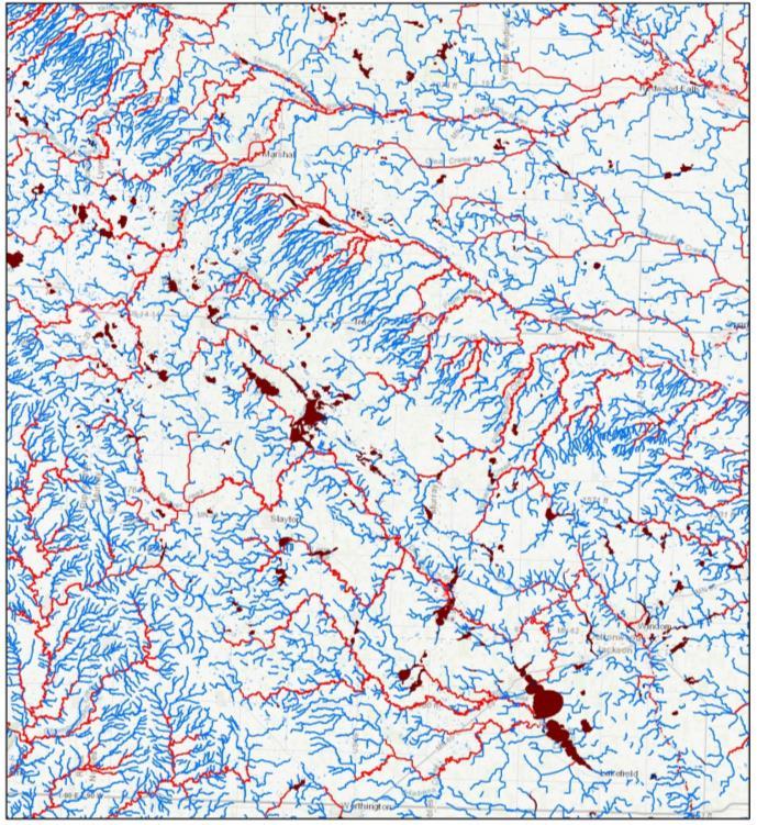
13 Lakes and Non- Wetland Basins Streams and Rivers 13


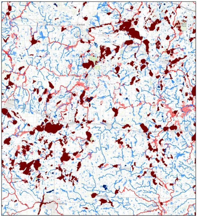
14 Wetlands Wetlands by Watershed Fewest assumable wetlands in NE. With the exception of 3 outliers, watersheds range from 0% to 45% assumable. Substantial majority are <25% assumable. 14


15 Wetlands by Land Ownership NE MN contains more public land. Public land may contain a higher proportion of wetlands. Permitting activity will generally be less on public land. NW Minnesota 15


16 North- Central Minnesota NE Minnesota 16


17 West- Central Minnesota Central Minnesota 17

18 East-Central Minnesota SW Minnesota 18


19 South- Central Minnesota SE Minnesota 19

20 Twin-Cities Metro Area COE Permitting Analysis The proportion of waters that are assumable may not directly correlate with permitting activity. The BWSR Resolution directs staff to compare the location of COE-permitted projects with the location and extent of assumable waters. Section 404 permitting data from 2012 to 2016 was obtained from the COE for this comparison. 20
21 COE Permit Location Comparison COE Permit Location Number Percent Falling within a COE-Retained Water 1, % Falling within a State-Assumable Water % Falling within a State-Only Water % Falling Outside a Mapped Water 4, % COE Permit Location Comparison Permits falling outside a mapped water do not suggest the permit was issued for activities in upland. Rather, likely sources of error could include: Permit location was not collected with sufficient accuracy. Impact location was marked as the center of a linear project. Mapping layers are not sufficiently accurate delineations of wetlands/waterbodies. Incorrect data entry. 21

22 COE Permit by Closest Proximity Permit locations falling outside a mapped water were assigned to the closest mapped water. COE Permit Location Proximity Number Percent Within or Closest to a COE-Retained Water 3, % Wihtin or Closest to a State-Assumable Water 1, % Within or Closest to a State-Only Water 1, % This analysis assumes that the nearest mapped water to the mapped permit location is the water that was in-fact affected by the permit activity and that may not be the case. COE Permits by Major Watershed COE permits can be compared to assumable wetlands by watershed. Wetlands were chosen as they are typically affected by permitted activities more so than lakes or streams. 22
23 The Number of COE Permits Compared to Assumable Wetlands for the Watersheds with the Highest Permit Density Major Watershed ID # Number of COE Permits Percent Assumable Wetlands % % % % % % % % % % % % % Permitting Analysis Conclusions Due to data limitations, none of the analyses yielded definitive conclusions. However, the observed results (particularly of the watershed comparison) suggest there is unlikely to be a dramatic difference between the amount of Stateassumable permitting activity and the amount of assumable waters, particularly on private lands. 23
24 Implementation The process by which a water s status is identified is equally important as the amount of assumable waters. Section 404 assumption goals of simplification and efficiency are affected by: 1) The ability to identify COE-retained and Stateassumable waters. 2) The distribution of COE-retained and State- Assumable waters. Identification Procedures The Feasibility Study concluded improved permitting timeframes for many projects under assumption. This conclusion presumed a known set of COEretained waters, which currently may not be possible. While some waters could be identified programmatically, other waters (particularly wetlands) would often require a case-by-case analysis to determine which agency has authority over a project. 24
25 Identification Procedures A case-by-case identification would likely be similar to the Section 404 Jurisdictional Determination process. For projects affecting wetlands, it would involve two steps: 1) Whether the wetland is considered adjacent to a non-wetland water(s). 2) Whether that water, or any of the waters it is adjacent to if multiple, is retained by the COE. Distribution of Waters and Regulatory Responsibilities The distribution of waters described in the COE letter creates a complicated patchwork of fragmented regulatory authorities. Wetlands adjacent to 2 or more water bodies are retained by the COE if any of the water bodies are retained. In some cases a stream could be assumed by the State, while its adjacent wetlands are retained by the COE. 25

26 Patchwork Example Patchwork Example 26
 Others, particularly wetlands, would not be known at the time of an application, requiring a case-by-case evaluation.")
27 Effects of Implementation Process on Potential Section 404 Assumption 1) The status of some waters could be known or determined relatively easily. 2) Others, particularly wetlands, would not be known at the time of an application, requiring a case-by-case evaluation. Modifications to the mapping criteria could change the amount of COE-retained waters, but not the process to identify them under the COE letter. Process adds complexity and uncertainty, diminishing the benefits of assumption to landowners and the State. 27

28 Assumable Waters Subcommittee Recommendations to EPA 1) COE-retained waters = Section 10 waters.* 2) COE-retained wetlands = wetlands within a set distance (e.g. 300 ft) from a retained water. *Except for those listed solely for historic use. Assumable Waters Subcommittee Recommendations would provide clarity and allow for: 1. A reasonable amount of waters to assume. 2. A known status of waters, identified and mapped programmatically. Federal government would need to take action to implement the recommendations. They would significantly improve the feasibility of Section 404 assumption in MN. 28
29 Overall Results & Conclusions A substantial majority of stream miles are assumable, while a substantial majority of lakes/basins and wetlands are retained. The COE has indicated that the results are not a very realistic estimation of the scope of retained waters or permit activity. State staff are unsure what steps could be done to produce a more realistic map. The process would often rely on case-by-case determinations, which could diminish potential gains in efficiency from 404 assumption. Implications for 404 Assumption in MN If two of the State s goals for assumption are to: 1) reduce redundancy by assuming most waters and permitting authority, and 2) improve efficiency of the process, then these results are not favorable for assumption. However, given the uncertainties associated with the results, it remains difficult to make a fully informed decision at this time. 29
30 BWSR, DNR, and PCA Letter to COE Requesting Identification of Retained Waters On , the agencies sent a letter to the COE to begin the process of preparing an MOA by: requesting the St. Paul District, in accordance with 40 CFR (b)(1), specifically identify the waters that would be retained by the Corps under Section 404 assumption in Minnesota. Greater certainty is needed for a State decision. The COE has the sole authority and necessary expertise to ID retained waters according to current regulations and interpretations. Next Steps 1. Finalize and post this report. 2. Support and cooperate with the Corps regarding the ID of retained waters. 3. Support Assumable Waters Subcommittee majority recommendations to clarify the ID of retained waters. 4. Begin coordination with EPA* to further identify: Specific state statute/rule changes. General framework of MOA. To gain a fuller understanding of the specific steps that would be necessary if the State were to pursue assumption. 30


31 Visit the BWSR website to review the original report and the Assumable Waters Analysis when posted. Questions?
2015 WETLAND CONSERVATION ACT STATUTE CHANGES
 2015 WETLAND CONSERVATION ACT STATUTE CHANGES Summary of Key Statute Changes and Related Legislation with Explanations This summary includes excerpts from Laws of MN 2015, Chapter 4, Article 4. It includes
LAKE OF THE WOODS COUNTY WETLAND CONSERVATION ORDINANCE OF 2002
 Ordinance # LAKE OF THE WOODS COUNTY WETLAND CONSERVATION ORDINANCE OF 2002 ARTICLE 1 TITLE AND PURPOSE Section 1.1. Title This Ordinance shall be known, cited and referred to as the Lake of the Woods
MUNICIPALITY OF ANCHORAGE PLANNING AND ZONING COMMISSION RESOLUTION NO
 MUNICIPALITY OF ANCHORAGE PLANNING AND ZONING COMMISSION RESOLUTION NO. 0-07 A RESOLUTION SUPPORTING THE APPROVAL AND ADOPTION OF THE ANCHORAGE WETLANDS MANAGEMENT PLAN. (Case 0-09) WHEREAS, the Anchorage
Minnesota Board of Water and Soil Resources Wetland Conservation Act 2017 Annual Reporting Form
 Minnesota Board of Water and Soil Resources Wetland Conservation Act 2017 Annual Reporting Form Use the tab key to navigate between fields. Local Government Unit (LGU): Becker SWCD Organization Type: SWCD
Jurisdictional Determination Request
 This form is intended for use by anyone requesting a jurisdictional determination (JD) from the U.S. Army Corps of Engineers, Wilmington District (Corps). Please include all supporting information, as
WETLAND MITIGATION BANKING OUTREACH SESSIONS
 WETLAND MITIGATION BANKING OUTREACH SESSIONS Minnesota State Wetland Bank Fee Policy Update Tim Smith Wetland Banking Coordinator MINNESOTA STATE WETLAND BANK FEE POLICY UPDATE Presentation Outline Banking
Establishing a Wetland Bank in Minnesota
 Establishing a Wetland Bank in Minnesota Updated February 1, 2018 This document provides a general summary of the key steps in establishing an individual wetland bank site within the state wetland banking
BUILD-OUT ANALYSIS GRANTHAM, NEW HAMPSHIRE
 BUILD-OUT ANALYSIS GRANTHAM, NEW HAMPSHIRE A Determination of the Maximum Amount of Future Residential Development Possible Under Current Land Use Regulations Prepared for the Town of Grantham by Upper
Buffer and Soil Loss Statutes, as amended in 2017 by Laws of Minnesota 2017, Chapter 93 (S.F. 844)
") Buffer and Soil Loss Statutes, as amended in 2017 by Laws of Minnesota 2017, Chapter 93 (S.F. 844) May 30, 2017 103B.101 BOARD OF WATER AND SOIL RESOURCES Subd. 12. Authority to issue penalty orders. (a)
Buffer and Soil Loss Statutes, as amended in 2017 by Laws of Minnesota 2017, Chapter 93 (S.F. 844) May 30, 2017 103B.101 BOARD OF WATER AND SOIL RESOURCES Subd. 12. Authority to issue penalty orders. (a)
Issues in Wetland Protection
 This document is made available electronically by the Minnesota Legislative Reference Library as part of an ongoing digital archiving project. http://www.leg.state.mn.us/lrl/lrl.asp John Helland, Legislative
engineering planning environmental construction
 engineering planning environmental construction 1648 Third Avenue SE Rochester, MN 55904 Tel: 507-289-3919 Fax: 507-289-7333 June 3, 2015 Mr. John Harford Rochester / Olmsted Planning Department 2122 Campus
EXHIBIT A. City of Corpus Christi Annexation Guidelines
 City of Corpus Christi Annexation Guidelines Purpose: The purpose of this document is to describe the City of Corpus Christi s Annexation Guidelines. The Annexation Guidelines provide the guidance and
Guide Note 15 Assumptions and Hypothetical Conditions
 Guide Note 15 Assumptions and Hypothetical Conditions Introduction Appraisal and review opinions are often premised on certain stated conditions. These include assumptions (general, and special or extraordinary)
AB 1397 HOUSING ELEMENT LAW SITE IDENTIFICATION STRENGTHENED OVERVIEW
 AB 1397 HOUSING ELEMENT LAW SITE IDENTIFICATION STRENGTHENED OVERVIEW The 2017 California legislative session yielded a housing package of 15 bills that significantly increased both the available financing
Administrative Penalty Order (APO) Plan for Buffer Law Implementation
 Plan for Buffer Law Implementation") Administrative Penalty Order (APO) Plan for Buffer Law Implementation June 28, 2017 This document was adopted by the Board of Water and Soil Resources (BWSR) pursuant to Minn. Stat. 103B.101, subd. 12(a)
Administrative Penalty Order (APO) Plan for Buffer Law Implementation June 28, 2017 This document was adopted by the Board of Water and Soil Resources (BWSR) pursuant to Minn. Stat. 103B.101, subd. 12(a)
ARLINGTON COUNTY, VIRGINIA. County Board Agenda Item Meeting of June 17, 2017
 ARLINGTON COUNTY, VIRGINIA County Board Agenda Item Meeting of June 17, 2017 DATE: June 9, 2017 SUBJECT: Request to authorize advertisement of public hearings by the Planning Commission and County Board
2015 Reinvest in Minnesota (RIM) Reserve Wetlands Program
 Reserve Wetlands Program") 2015 Reinvest in Minnesota (RIM) Reserve Wetlands Program Eligibility Guidance Document 1/16/15 The purpose of the RIM Wetlands Program is to identify and enroll under permanent easement lands that contain
2015 Reinvest in Minnesota (RIM) Reserve Wetlands Program Eligibility Guidance Document 1/16/15 The purpose of the RIM Wetlands Program is to identify and enroll under permanent easement lands that contain
ASSURANCE AND ACCOUNTING ASPE - IFRS: A Comparison Investment Property
 ASSURANCE AND ACCOUNTING ASPE - IFRS: A Comparison Investment Property In this publication we will examine the key differences between Accounting Standards for Private Enterprises (ASPE) and International
Market Value Assessment and Administration
 Market Value and Administration This technical document is part of a series of draft discussion papers created by Municipal Affairs staff and stakeholders to prepare for the Municipal Government Act Review.
CERTIFIED SURVEY MAPS
 Chapter 1 - INTRODUCTION CERTIFIED SURVEY MAPS Certified Survey Maps (CSMs) are one of the permitted methods of dividing land in the City of Muskego. CSMs are allowed when it is proposed to create four
Community Development Committee
 C Date Prepared: Subject: Community Development Committee For the Metropolitan Council meeting of December 9, 2009 December 8, 2009 Committee Report SW Item: 2009-444 ADVISORY INFORMATION Rice Creek Chain
SECTION 10: FLOOD HAZARD EVALUATION 10-1
 10) SECTION 10: FLOOD HAZARD EVALUATION A. General. Land subject to being flooded by a Flood of 100-Year Frequency as defined by Title 76, Chapter 5, MCA, or land subject to flooding pursuant to these
ORDINANCE CITY OF DUNDAS RICE COUNTY STATE OF MINNESOTA
 ORDINANCE 2014 01 CITY OF DUNDAS RICE COUNTY STATE OF MINNESOTA An Ordinance Amending Dundas City Code Title 5, Public Works, to Add Chapter 504 Storm Water Utility RECITALS There is hereby established
ARTICLE 3: Zone Districts
 ARTICLE 3: Zone Districts... 3-1 17.3.1: General...3-1 17.3.1.1: Purpose and Intent... 3-1 17.3.2: Districts and Maps...3-1 17.3.2.1: Applicability... 3-1 17.3.2.2: Creation of Districts... 3-1 17.3.2.3:
International Valuation Standards Update
 International Valuation Standards Update Adam Smith Interim Technical Director of Business Valuation Standards OIV International Business Valuation Conference January 16, 2017 INTERNATIONAL VALUATION STANDARDS
Amendments to the Low-Income Housing Credit Compliance-Monitoring Regulations. ACTION: Final regulations and removal of temporary regulations.
 This document is scheduled to be published in the Federal Register on 02/26/2019 and available online at https://federalregister.gov/d/2019-03388, and on govinfo.gov [4830-01-p] DEPARTMENT OF THE TREASURY
REAL ESTATE PLAN APPENDIX G
 Pacific Ocean Division REAL ESTATE PLAN APPENDIX G Alaska District UNALASKA (DUTCH HARBOR) CHANNELS UNALASKA, ALASKA Real Estate Division Alaska District U.S. Army Corps of Engineers TABLE OF CONTENTS
Conservation Easement Stewardship
 Conservation Easements are effective tools to preserve significant natural, historical or cultural resources. Conservation Easement Stewardship Level of Service Standards March 2013 The mission of the
IASB Exposure Draft ED/2013/6 - Leases
 ACAG AUSTRALASIAN COUNCIL OF AUDITORS GENERAL 13 September 2013 Mr Hans Hoogervorst Chairman International Accounting Standards Board 30 Cannon Street London EC4M 6XH United Kingdom Dear Mr Hoogervorst
Public Notice U.S. ARMY CORPS OF ENGINEERS, GALVESTON DISTRICT AND TEXAS COMMISSION ON ENVIRONMENTAL QUALITY
 Public Notice U.S. Army Corps Permit Application No: SWG-2016-00384 Of Engineers Date Issued: 27 December 2018 Galveston District Comments Due: 29 January 2019 U.S. ARMY CORPS OF ENGINEERS, GALVESTON DISTRICT
Establishing an Individual Wetland Bank Site in Minnesota
 Establishing an Individual Wetland Bank Site in Minnesota March 14, 2013 This document provides a general summary of the key steps in establishing a an individual wetland bank site within the state wetland
Chapter 5. Floodplain Management. 5.0 Introduction. 5.1 Floodplain Management and Regulation
 5.0 Introduction This chapter summarizes the Town s rules and regulations regarding floodplain management and development. The requirements presented in this chapter should be used by the design engineer
The Strategic Plan can be viewed by clicking this link.
 What is the purpose of the Land Information Office? Many of Brown County's most basic services rely on accurate and up-to-date land information. Emergency response, resource conservation, infrastructure
Draft Integrated Feasibility Report and Environmental Assessment and Draft Finding of No Significant Impact
 Draft Integrated Feasibility Report and Environmental Assessment and Draft Finding of No Significant Impact APPENDIX F: REAL ESTATE Whittier, Alaska June 2018 Pacific Ocean Division DRAFT REAL ESTATE
Environment and Natural Resources Trust Fund Request for Proposals (RFP)
") Environment and Natural Resources Trust Fund 2012-2013 Request for Proposals (RFP) Project Title: Southeast Minnesota Sensitive Habitat Protection Program (SHPP) ENRTF ID: 067-D Topic Area: D. Land Acquisition
Environment and Natural Resources Trust Fund 2012-2013 Request for Proposals (RFP) Project Title: Southeast Minnesota Sensitive Habitat Protection Program (SHPP) ENRTF ID: 067-D Topic Area: D. Land Acquisition
We look forward to working with you to build on our collaboration and enhance our partnership on behalf of all Minnesotans.
 Date: February 27, 2017 To: County Assessors, Auditors, and Treasurers From: Cynthia Rowley, Director Property Tax Division Subject: Property Tax Services Report The Property Tax Division of the Minnesota
(Continued on back of page)
") Definitions Certificate of Survey is the subdivision of land into three or fewer tracts of land. The remnant tract counts as one tract. Plat is the subdivision of land into more than three tracts of land.
Definitions Certificate of Survey is the subdivision of land into three or fewer tracts of land. The remnant tract counts as one tract. Plat is the subdivision of land into more than three tracts of land.
FLATHEAD COUNTY PLANNING AND ZONING OFFICE WHITEFISH AREA ZONING DISTRICT REQUEST FOR ESTABLISHMENT OF A ZONING DISTRICT
 FLATHEAD COUNTY PLANNING AND ZONING OFFICE WHITEFISH AREA ZONING DISTRICT REQUEST FOR ESTABLISHMENT OF A ZONING DISTRICT STAFF REPORT #FZD-08-02 DECEMBER 1, 2008 A report to the Flathead County Planning
Extending the Right to Buy
 Memorandum for the House of Commons Committee of Public Accounts Department for Communities and Local Government Extending the Right to Buy MARCH 2016 4 Key facts Extending the Right to Buy Key facts 1.8m
METROPOLITAN COUNCIL 390 North Robert Street, St. Paul, MN Phone (651) TDD (651)
 TDD (651)") METROPOLITAN COUNCIL 390 North Robert Street, St. Paul, MN 55101 Phone (651) 602-1000 TDD (651) 291-0904 DATE: November 23, 2009 TO: Metropolitan Parks and Open Space Commission FROM: Jan Youngquist, Senior
METROPOLITAN COUNCIL 390 North Robert Street, St. Paul, MN 55101 Phone (651) 602-1000 TDD (651) 291-0904 DATE: November 23, 2009 TO: Metropolitan Parks and Open Space Commission FROM: Jan Youngquist, Senior
Brief Summary of Drainage Law. November 2011
 Brief Summary of Drainage Law November 2011 This document is general information distributed by the State of South Dakota. Nothing in this document should be considered legal advice as to any specific
Housing White Paper Summary. February 2017
 Housing White Paper Summary February 2017 On Tuesday 7 February, the government published the Housing White Paper, aimed at solving the housing crises in England through increasing the supply of homes
This article is relevant to the Diploma in International Financial Reporting and ACCA Qualification Papers F7 and P2
 REVENUE RECOGNITION This article is relevant to the Diploma in International Financial Reporting and ACCA Qualification Papers F7 and P2 For almost all entities other than financial institutions, revenue
FRESHWATER WETLANDS PROTECTION IN NEW JERSEY Tools for Municipal Action
 FRESHWATER WETLANDS PROTECTION IN NEW JERSEY Tools for Municipal Action The Freshwater Wetlands Protection Act INTENT OF FRESHWATER WETLANDS LAW The New Jersey legislature passed the Freshwater Wetlands
Cadastral and Right of Way Data Sharing
 Cadastral and Right of Way Data Sharing May 2010 TRS 1006 This Transportation Research Synthesis (TRS) provides summaries of recent research and implementation efforts on a topic of current interest. Online
STATE SEPTIC CODE EXAMPLES:
 RESEARCH REPORT July 5, 2017 By Grenetta Thomassey, PhD and Jay Dutcher STATE SEPTIC CODE EXAMPLES: Connecticut page 1 Iowa page 3 Minnesota page 5 Pennsylvania page 7 Wisconsin page 10 STATE SEPTIC CODE
BWSR MN Public Drainage Manual Broad Users Outreach Workshop John Kolb, Attorney Lead Writer Chapter 4. MPDM Chapter 4: Viewing and Appraising
 BWSR MN Public Drainage Manual Broad Users Outreach Workshop John Kolb, Attorney Lead Writer Chapter 4 MPDM Chapter 4: Viewing and Appraising Chapter 4 Subcommittee Members 2 Sherry Enzler, MN DNR Bob
Walworth County Farmland Preservation Plan Update, Chapter 1 Plan Summary (Cover Document)
") Background Walworth County Farmland Preservation Plan Update, 2012 Chapter 1 Plan Summary (Cover Document) For over 30-years, the Wisconsin Farmland Preservation Program has served to preserve Walworth
Background Walworth County Farmland Preservation Plan Update, 2012 Chapter 1 Plan Summary (Cover Document) For over 30-years, the Wisconsin Farmland Preservation Program has served to preserve Walworth
Regulatory Impact Statement
 Regulatory Impact Statement Establishing one new special housing area in Queenstown under the Housing Accords and Special Housing Areas Act 2013. Agency Disclosure Statement 1 This Regulatory Impact Statement
250 CMR: BOARD OF REGISTRATION OF PROFESSIONAL ENGINEERS AND LAND SURVEYORS DRAFT FOR DISCUSSION PURPOSES ONLY
 250 CMR 6.00: LAND SURVEYING PROCEDURES AND STANDARDS Section 6.01: Elements Common to All Survey Works 6.02: Survey Works of Lines Affecting Property Rights All land surveying work is considered work
PART ONE - GENERAL INFORMATION
 Corrected Date: Page 7 Date of Submittal Changed to Coincide with Submittal Date on Page 5 PART ONE - GENERAL INFORMATION A. INTRODUCTION B. Background Miami Shores Village is soliciting responses to this
Township of Collier 2418 Hilltop Road Presto, PA 15142
 Township of Collier 2418 Hilltop Road Presto, PA 15142 Fees: Major: 2 checks $600 + $50 per lot & $1700 Escrow) APPLICATION FOR SUBDIVISION major FINAL only Plans must be folded Rolled plans will not be
BOA David Hollerich Centerline Setback Variance 09/05/2012
 BOA 10-12 David Hollerich Centerline Setback Variance 09/05/2012 Request for variance to reduce the required centerline setback from Granite Circle of 65 feet to 40 feet for a proposed farm equipment building
General Development Plan Background Report on Agricultural Land Preservation
 General Development Plan 2008 Background Report on Agricultural Land Preservation February 2008 I. Introduction Anne Arundel County has been an agricultural community for over 350 years, beginning with
Residential Capacity Estimate
 Residential Capacity Estimate Montgomery County Department of Park & Planning Research & Technology Center January 2005 Current plans allow 75,000 more housing units. by Matthew Greene, Research Planner
Changes to the SFIA Program:
 Changes to the SFIA Program: What it means for landowners and service providers SFEC U of MN Extension Webinar January 16, 2018 John Carlson MN DNR Forestry Private Forest Management/SFIA Program Coordinator
METHODOLOGY GUIDE VALUING LANDS IN TRANSITION IN ONTARIO. Valuation Date: January 1, 2016
 METHODOLOGY GUIDE VALUING LANDS IN TRANSITION IN ONTARIO Valuation Date: January 1, 2016 August 2017 August 22, 2017 The Municipal Property Assessment Corporation (MPAC) is responsible for accurately assessing
Central Pennsylvania Conservancy Project Selection Criteria Form
 Central Pennsylvania Conservancy Project Selection Criteria Form The following criteria guide the actions of the Central Pennsylvania Conservancy s Land Protection Committee and Board of Directors in selecting
ORDINANCE NO.: Adopted: August 2, 2005 Amended: March 27, 2007 Amended: September 23, Fillmore County Rural Addressing Ordinance
 ORDINANCE NO.: 2005-01 Adopted: August 2, 2005 Amended: March 27, 2007 Amended: September 23, 2008 Fillmore County Rural Addressing Ordinance Section 1 Purpose, Scope and Statutory Authorization 1-1 Purpose.
Easements: Ditch and flowage easements will be terminated upon sale.
 Property #156084: Otter Tail County Parcel Removed from Sale Containing 58.20 acres, more or less. Property Data Sheet 156084 Parts of the Southeast Quarter of the Northeast Quarter (SE1/4, NE1/4), Government
Darren Wyss, Associate Planner, Community Development Department
 Agenda Bill 2019-03-11-01 Date: February 25, 2019 Meeting Date: March 11, 2019 To: From: Through: Russ Axelrod, Mayor Members, West Linn City Council Darren Wyss, Associate Planner, Community Development
Subject: LandWatch s comments on Salinas Economic Development Element FEIR. Dear Mayor Gunter and Members of the Salinas City Council:
 December 4, 2017 Via hand delivery and e-mail Mayor Joe Gunter City of Salinas 200 Lincoln Avenue Salinas, CA 93901 council@ci.salinas.ca.us Subject: LandWatch s comments on Salinas Economic Development
AFFIRMATIVELY FURTHERING FAIR HOUSING
 FINAL REGULATIONS AFFIRMATIVELY FURTHERING FAIR HOUSING Ed Gramlich (ed@nlihc.org) National Low Income Housing Coalition Modified, October 2015 INTRODUCTION On July 8, 2015, HUD released the long-awaited
NYC Land Acquisition Town Level Assessment 2017
 NYC Land Acquisition Town Level Assessment 2017 Delaware County Evaluation and Response Delaware County assessment of the NYC Land Acquisition Program and how potential future LAP acquisitions affect the
ATTACHMENT 2 - PROJECT CHARTER
 PROJECT NAME: Housing Strategy 2014 CURRENT PHASE: Phase I VERSION # PROJECT TEAM: Melissa Aldunate, Manager of Policy Planning and Urban design Joan Jylanne, Senior Policy Planner Tim Donegani, Policy
Impact Fee Nexus & Economic Feasibility Study
 Impact Fee Nexus & Economic Feasibility Study Stakeholder Working Group December 10, 2015 Urban Economics Agenda Follow Up From Last Meeting Proposals Presentation Proposals Discussion Wrap Up 1 Oakland
LARAMIE COUNTY PLANNING & DEVELOPMENT DEPARTMENT
 LARAMIE COUNTY PLANNING & DEVELOPMENT DEPARTMENT Planning Building MEMORANDUM TO: FROM: Laramie County Board of Commissioners Brad Emmons, Planning Director DATE: May 15, 2018 TITLE: Review and action
Agreements for the Construction of Real Estate
 HK(IFRIC)-Int 15 Revised August 2010September 2018 Effective for annual periods beginning on or after 1 January 2009* HK(IFRIC) Interpretation 15 Agreements for the Construction of Real Estate * HK(IFRIC)-Int
STAFF REPORT. Meeting Date: April 25, 2017
 Meeting Date: April 25, 2017 Agency: City of Belmont Staff Contact: Damon DiDonato, Community Development Department, (650) 637-2908; ddidonato@belmont.gov Agenda Title: Amendments to Sections 24 (Secondary
Criteria for Appeals of Flood Insurance Rate Maps. November 30, 201 1
 Criteria for Appeals of Flood Insurance Rate Maps November 30, 201 1 This document outlines the criteria for appealing proposed changes in flood hazard information on Flood Insurance Rate Maps (FIRMS)
MINUTES EXECUTIVE MEETING MAY 30, 2018
 The meeting was called to order at 11:26 p.m. Present: Supervisors: Kermes, Prudhon, Ruzek; Clerk: Short; Attorney: Lemmons; Finance Officer: Kelly; Code Enforcement Officer: Johnson; Planner: Riedesel;
Chapter 5. Floodplain Management. 5.0 Introduction. 5.1 Douglas County Comprehensive Master Plan. 5.2 Floodplain Management and Regulation
 5.0 Introduction This chapter summarizes the County s rules and regulations regarding floodplain management and development. The requirements presented in this chapter should be used by the design engineer
This version includes amendments resulting from IFRSs issued up to 31 December 2009.
 International Accounting Standard 40 Investment Property This version includes amendments resulting from IFRSs issued up to 31 December 2009. IAS 40 Investment Property was issued by the International
Construction & Earthwork Request Form (CERF)
") ShoreLand Traditions Construction & Earthwork Request Form (CERF) SECTION 1 SECTION 2 SECTION 3 Definitions and Points to Remember Requirements and Process Site Sketch Requirements and Sample If you have
ShoreLand Traditions Construction & Earthwork Request Form (CERF) SECTION 1 SECTION 2 SECTION 3 Definitions and Points to Remember Requirements and Process Site Sketch Requirements and Sample If you have
METROPOLITAN COUNCIL 390 North Robert Street, St. Paul, MN Phone (651) TDD (651)
 TDD (651)") METROPOLITAN COUNCIL 390 North Robert Street, St. Paul, MN 55101 Phone (651) 602-1000 TDD (651) 291-0904 DATE: December 3, 2012 TO: Metropolitan Parks and Open Space Commission FROM: Arne Stefferud, Manager
METROPOLITAN COUNCIL 390 North Robert Street, St. Paul, MN 55101 Phone (651) 602-1000 TDD (651) 291-0904 DATE: December 3, 2012 TO: Metropolitan Parks and Open Space Commission FROM: Arne Stefferud, Manager
Public Notice. Applicant: Avere Real Estate Project No.: SWF Date: May 30, Phone Number:
 Public Notice Applicant: Avere Real Estate Project No.: SWF-2017-00150 Date: May 30, 2017 Purpose The purpose of this public notice is to inform you of a proposal for work in which you might be interested.
ASSESSMENT AND CLASSIFICATION PRACTICES REPORT LANDS ENROLLED IN STATE OR FEDERAL CONSERVATION PROGRAMS
 ASSESSMENT AND CLASSIFICATION PRACTICES REPORT LANDS ENROLLED IN STATE OR FEDERAL CONSERVATION PROGRAMS A report submitted to the Minnesota State Legislature pursuant to Minnesota Laws 2005, First Special
04.08 SPECIAL VALUATIONS AND DEFERRALS
 04.08 SPECIAL VALUATIONS AND DEFERRALS Deferral programs recognize that market value of certain types of property may exceed the value that would be determined if the property were limited to its current
Notice of Intent Supplemental Form for Riverfront Area
 Notice of Intent Supplemental Form for Riverfront Area The Notice of Intent Supplemental Form for Riverfront Area is recommended for use with the Notice of Intent (Form 3) in the wetland regulations (310
KPMG s CFO. Webcast. Administrative
 KPMG s CFO Financial Forum Webcast A Detailed Look at the FASB/IASB Revised Leases Exposure Drafts Part I (Scope, Definition, and Lease Classification) June 13, 2013 Administrative CPE regulations require
Environment and Natural Resources Trust Fund (ENRTF) M.L Work Plan
 M.L Work Plan") Environment and Natural Resources Fund (ENRTF) M.L. 2015 Work Plan Date of Report: May 14, 2015 Date of Next Status Update Report: February 1, 2016 Date of Work Plan Approval: Project Completion Date:
Environment and Natural Resources Fund (ENRTF) M.L. 2015 Work Plan Date of Report: May 14, 2015 Date of Next Status Update Report: February 1, 2016 Date of Work Plan Approval: Project Completion Date:
RULE F: WETLAND ALTERATION
 RULE F: WETLAND ALTERATION 1. POLICY. It is the policy of the Board of Managers to: (a) (b) (c) (d) (e) Maintain no net loss in the quantity, quality, and biological diversity of Minnesota's existing wetlands.
Validation Checklist. Date submitted: How to use this check-list. Ecosystem Credit Accounting System. Version 1.1&2. Project Information
 Ecosystem Credit Accounting System Version 1.1&2 Last updated April 21, 2017 Validation Checklist Date submitted: Project Information Project Name Trading Area Name Trading Area Type (e.g., TMDL, TNC Ecoregion)
{{t:t;r:n;o:"signer 2";l:"Date";}}
 Application/File # Date Application Rec'd: Oct 13 2017 Fee Collected $ (for office use only) CONDITIONAL USE APPLICATION MOTLEY MN Site Address (E-911#): 164 MORRISON STREET WEST 410095000 Lake/River Name:
Georgia Conservation Tax Credit Program Frequently Asked Questions
 Georgia Conservation Tax Credit Program Frequently Asked Questions What are the minimum requirements for eligibility under the Georgia Conservation Tax Credit Program (GCTCP)? Individual and corporate
Real Estate Appraisal Professional Standards
 Real Estate Appraisal Professional Standards Summary This proposal is to amend the Florida Administrative Code (FAC) to allow a Certified Residential Appraiser or a Certified General Appraiser to use standards
THE MARIN COUNTY HOUSING ELEMENT AND TAM VALLEY
 THE MARIN COUNTY HOUSING ELEMENT AND TAM VALLEY The Marin County Community Development Agency is currently working toward completion of the Housing Element of the County s general plan (the Marin Countywide
KNOXVILLE/KNOX COUNTY METROPOLITAN PLANNING COMMISSION PLAN AMENDMENT/REZONING REPORT
 KNOXVILLE/KNOX COUNTY METROPOLITAN PLANNING COMMISSION PLAN AMENDMENT/REZONING REPORT FILE #: 4-G-12-RZ 4-C-12-SP AGENDA ITEM #: 27 AGENDA DATE: 5/10/2012 POSTPONEMENT(S): 4/12/12 APPLICANT: OWNER(S):
PERMANENT WETLANDS PRESERVE (PWP) ELIGIBILITY INFORMATION
 ELIGIBILITY INFORMATION") PERMANENT WETLANDS PRESERVE (PWP) ELIGIBILITY INFORMATION A. WETLANDS ELIGIBLE FOR PERMANENT WETLANDS PRESERVE A.1 Statutory Purpose A.2 Program Goals A.3 Hydrologic Regimes A.4 Wetland Types B. PERMANENT
PERMANENT WETLANDS PRESERVE (PWP) ELIGIBILITY INFORMATION A. WETLANDS ELIGIBLE FOR PERMANENT WETLANDS PRESERVE A.1 Statutory Purpose A.2 Program Goals A.3 Hydrologic Regimes A.4 Wetland Types B. PERMANENT
COMMUNITY DEVELOPMENT DEPARTMENT
 AGENDA ITEM I-1 COMMUNITY DEVELOPMENT DEPARTMENT Council Meeting Date: June 3, 2014 Agenda Item #: I-1 INFORMATIONAL ITEM: Update on Multi-City Affordable Housing Nexus Study and Impact Fee Feasibility
IFA submission to the Law Reform Commission of Ireland s review of the current law on compulsory acquisition of land.
 IFA submission to the Law Reform Commission of Ireland s review of the current law on compulsory acquisition of land. The Irish Farm Centre Bluebell Dublin 12 February 2018 Introduction The Issues Paper
Request to Advertise: Chesapeake Bay Preservation Area (CBPA) Map Update. June 20, 2017
 Map Update. June 20, 2017") Request to Advertise: Chesapeake Bay Preservation Area (CBPA) Map Update June 20, 2017 Outline Context Past County Board actions Why update the CBPA Map? What and Why - Resource Protection Areas Property
Request to Advertise: Chesapeake Bay Preservation Area (CBPA) Map Update June 20, 2017 Outline Context Past County Board actions Why update the CBPA Map? What and Why - Resource Protection Areas Property
MODEL CONSERVATION RESTRICTION AMENDMENT POLICY GUIDELINES Massachusetts Easement Defense Subcommittee March 6, 2007 PREAMBLE
 MODEL CONSERVATION RESTRICTION AMENDMENT POLICY GUIDELINES Massachusetts Easement Defense Subcommittee March 6, 2007 PREAMBLE Because conservation restrictions are an important tool for permanently protecting
EFRAG s Letter to the European Commission Regarding Endorsement of Transfers of Investment Property
 Regarding Endorsement of Transfers of Investment Property Olivier Guersent Director General, Financial Stability, Financial Services and Capital Markets Union European Commission 1049 Brussels 6 April
IAS Revenue. By:
 IAS - 18 Revenue International Accounting Standard No 18 (IAS 18) Revenue In 1998, IAS 39, Financial Instruments: Recognition and Measurement, amended paragraph 11 of IAS 18, adding a cross-reference to
FRESHWATER WETLANDS LETTER OF INTERPRETATION (LOI) APPLICATION CHECKLIST AND FEE TABLE (Updated March 2016)
 APPLICATION CHECKLIST AND FEE TABLE (Updated March 2016)") State of New Jersey Department of Environmental Protection Land Use Regulation Program Mail Code 501-02A PO Box 420 Trenton, NJ 08625-0420 Fax# (609)-777-3656 www.nj.gov/dep/landuse/ FRESHWATER WETLANDS
State of New Jersey Department of Environmental Protection Land Use Regulation Program Mail Code 501-02A PO Box 420 Trenton, NJ 08625-0420 Fax# (609)-777-3656 www.nj.gov/dep/landuse/ FRESHWATER WETLANDS
The Bonus Zoning policy will be applied in conjunction with the Implementation policies contained within the Official Plan.
 Policy Title: Bonus Zoning Policy Number: 07-03-01 Section: Community Development Subsection: Planning Tools Effective Date: September 26, 2012 Last Review Date: Approved by: Council Owner Division/Contact:
Implementation Tools for Local Government
 Information Note #5: Implementation Tools for Local Government This Information Note is a guide only. It is not a substitute for the federal Fisheries Act, the provincial Riparian Areas Regulation, or
Protection for Residents of Long Term Supported Group Accommodation in NSW
 Protection for Residents of Long Term Supported Group Accommodation in NSW Submission prepared by the NSW Federation of Housing Associations March 2018 Protection for Residents of Long Term Supported Group
To provide for the review of the final engineering plans, the subdivision improvement agreement, public dedications, and other legal agreements.
 ARTICLE 5 FINAL PLAT 501 Intent DOUGLAS COUNTY SUBDIVISION RESOLUTION To provide for the review of the final engineering plans, the subdivision improvement agreement, public dedications, and other legal