Cherokee Webster Development, LP. City of Webster, Texas Planned Development No. 3. Proposed Revision No. 4
|
|
|
- Susanna Long
- 5 years ago
- Views:
Transcription

1 Cherokee Webster Development, LP. City of Webster, Texas Planned Development No. 3 Proposed Revision No. 4 October
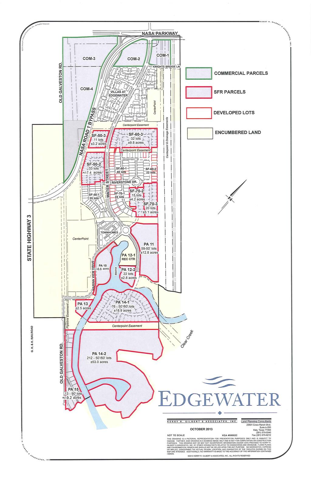
2 Statement of Intent This Revision No. 4 of the Statement of Intent is written in the 7 th year of development of the Edgewater Master Planned Community. The text will therefor reflect on development that has been completed, is in process or is yet to be completed. The former Texas Genco Power Plant Site, known now as Edgewater, is a 537 Acre tract of land extending from NASA Parkway, south to Clear Creek. The east and west sides of the site are bounded by power transmission easements which feed two (2) power switchyards located on the site. Although these easements are have no development potential, they continue to serve a useful function for CenterPoint Energy with the Edgewater project. Net of the transmission easements and switchyards, there are by this account approximately 250 acres that can be developed. See Exhibit: Conceptual Land Use Plan. The NASA Parkway Bypass, otherwise referred to by TXDOT as NASA Road 1, penetrates the western boundary of the site and traverses northeasterly through Edgewater, intersecting NASA Parkway on the northern boundary. It should be noted that TXDOT prohibits direct driveway or street access to that segment of the Bypass that passes through Edgewater. Primary access to developable property within Edgewater is provided by NASA Parkway and by Water Street, a north-south boulevard spine street connecting to NASA Parkway opposite Sarah Deel Lane. Knights Bridge Lane intersects Water Street and connects Edgewater with the Green Acres subdivision to the east. Marina View Drive intersects Water Street at a traffic circle, or roundabout, and will one day connect with SH 3 to the west. A corridor has been set aside in Edgewater to accommodate street right-of-way for the extension of Henderson Avenue between FM 270 and the roundabout on Water Street, should the City of Webster one day find that the connection is warranted. The northern end of Edgewater is anticipated to be developed as primarily a commercial and retail corridor fronting or siding on NASA Parkway and Water Street. Moving south along Water Street between NASA Parkway and the roundabout, the 414 unit for-rent Arium multifamily housing development is in its 5 th year of existence with occupancy at 95%. South of Arium and separated by a common area, the mid-section of Edgewater is partially developed with 60 and 70 wide residential lots on PA7, and 50 lots and townhome lots on PA 9. See Exhibit: Development Status Map. Located south of the roundabout between PA 7 & PA 9 and PA 14 are PA 10 with potential condo convertible, for-rent multi-family housing, PA 11, with potential for mixed-use development and PA 12, with potential for townhome single family living. PA 10 and 12 will take advantage of inlet waters connecting to Clear Creek enhancing development frontage and views. The southern end of Edgewater, PA 14, is anticipated to be developed as single family residential home sites of various widths for a broad range of mid to upper-end homes. Many of these home sites are expected to have direct access to canals which will lead to Clear Creek, 2
3 and thus Clear Lake and Galveston Bay. Land area is being preserved at the southern end of PA 14 for public access See Exhibits: Open Space Plan Edgewater is intended to be a pedestrian oriented, community with sidewalks, open space and landscape reserves throughout, while meeting City of Webster requirements for parking, screening, and roadways. Edgewater continues to be viewed as an exciting development in the City of Webster that will serve as a catalyst for the surrounding area and enhance the development of other surrounding properties. Great care is being taken to showcase and preserve natural features unique to this site while providing potential growth for City revenues and creating a high quality of life for its residents. The matrix that follows outlines Edgewater s proposed land use by acreage, densities, and the minimum and maximum acres and percentage of non-residential, for-rent residential and forsale residential acres. Respectfully submitted, By: Cherokee Webster Development, L.P. Robert B. Douglas, Jr., General Manager 3
4 Development Matrix August 2010 Submittal: A. Retail / Commercial Parcels Acres 1. PA PA PA PA A. Total 40.6 B. Mixed Use / Alternative Development District Nos. 1 & 2 Parcels Acres Max Density Max Res Units Proposed Use 1. PA Retail/commercial or for-sale res 2. PA Retail/commercial or for-sale res 3. PA Retail/commercial or for-sale res B. Totals C. For-Sale Residential - Residential District Nos. 2, 3 & 4 Parcels Acres Max Density Max Res Units Proposed Use 1. PA Single-family for-sale residential 2. PA 9a Single-family for-sale residential 3. PA 9b Single-family for-sale residential 4. PA Single-family for-sale residential C. Totals D. For-Rent Residential - Multi-Family Residential District Parcels Acres Max Density Max Res Units Proposed Use 1. PA For-rent residential 2. PA For-rent residential D. Totals E. For-Sale Residential - Residential District No. 1 Parcels Acres Max Density Max Res Units Proposed Use 1. PA Single-family for-sale residential 2. PA Single-family for-sale residential E. Totals Total Acres Summary Min Res Acres % Of Acres Non-Residential 40.6 [1] 16% For Rent Residential 27.0 [2] 11% For Sale Residential [3] 73% Total Acres % [1] A; [2] D; [3] B+C+E 4
5 Development Matrix October 2013 Submittal: A. Retail / Commercial Parcels Acres 1. PA PA PA PA A. Total 40.6 B. Mixed Use / Alternative Development District Nos. 1 Parcels Acres Max Density Max Res Units Proposed Use 1. PA High density, mid-rise or single-family for-sa for-sale residential B. Totals C. For-Sale Residential - Residential District Nos. 2, 3 & 4 Parcels Acres Max Density Max Res Units Proposed Use 1. PA Single-family for-sale residential 2. PA 9a Single-family for-sale residential 3. PA 9b Single-family for-sale residential 4. PA Single-family for-sale residential 5. PA Single-family for-sale residential C. Totals D. For-Rent Residential - Multi-Family Residential District Parcels Acres Max Density Max Res Units Proposed Use 1. PA For-rent residential 2. PA For-rent residential 3. PA Condo-convertible for-rent residential D. Totals E. For-Sale Residential - Residential District No. 1 Parcels Acres Max Density Max Res Units Proposed Use 1. PA Single-family for-sale residential 2. PA Single-family for-sale residential E. Totals Total Acres Summary Acres % Of Acres Res Units Non-Residential 40.6 [1] 16% 0 For Rent Residential 33.6 [2] 14% 843 For Sale Residential [3] 70% 1,137 Total Acres % 1,980 [1] A; [2] D; [3] B+C+E 5
6 Density Comparison Chart EDGEWATER City of Webster PD No. 3, Revision No. 4 October 2013 Submittal August 2010 Submittal Land Use PA No. Acres U/A Units PA No. Acres U/A Units Retail/Commercial PA PA PA PA PA PA PA PA Totals Alternative/Development District No. 1 PA PA PA Totals Alternative/Development District No. 2 PA Totals Residential District Nos. 2, 3, 4 PA PA Single-Family For-Sale PA 8 Deleted PA 8 Deleted PA 9a PA 9a PA 9b PA 9b PA PA PA Totals TTL : Multi-Family Res District PA PA For-Rent PA PA PA Totals Residential District Nos. 2, 3, 4 For Sale PA PA PA PA Totals Grand Totals
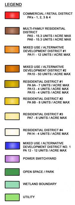
7 Edgewater is divided into the following Development Districts which correspond to Planning Areas, or PA s, indicated on the Outline Plan: Commercial / Retail District: CHANGED TO INCLUDE ALL C-2 ZONING USES PA 1, 2, 3 & 4 Intent: This district is intended to allow for all market driven land uses permitted under C-2 zoning. Uses: Shopping Centers, Retail Centers, Office Uses (medical, general office, etc.), Entertainment Centers (Theaters, etc.), Commercial Uses, Medical and Care Facilities (group housing, state licensed, assisted living center). Uses to generally comply with C-2 Second Commercial District, as defined in City of Webster Zoning Regulations. Density: PA 1 Per C-2 Zoning PA 2 Per C-2 Zoning PA 3 Per C-2 Zoning PA 4 Per C-2 Zoning Height Restrictions: 55 to 65 Multi-Family Residential District: CHANGED TO INCLUDE PA 10 PA 5 & 6 Intent: This district includes multi-family residential housing. Use complies with the Multi- Family District as defined in the City of Webster Zoning Regulations. Density: PA U/A approved by City and subsequently developed PA U/A approved by City and subsequently developed Height Restrictions: 55 to 65 PA 10 Location Change: The location of PA 10 swapped with that of PA 11. Intent: This development is intended as follows: A. Mid-rise rental residential housing constructed with Condominium Style features which will allow for the conversion to For-Sale condominiums when determined to be an appropriate market decision. Features that would be designed into each multi-family home include: 1. Pre-planned documents to readily facilitate: i. The creation of a condominium association. ii. The conversion of dwelling units from rental to owned. 7
8 2. Not less than 75% and up to100% exterior masonry finish. 3. Enclosed multi-story concrete parking garage. 4. State-of-the-art home security, telecommunications and high speed internet systems. 5. Secure building access points. 6. Enclosed common area courtyards. 7. Individual water and electric meters for each dwelling unit. 8. Expanded kitchens and bathrooms. 9. Upgraded interior finishes which may include granite counter tops, stainless steel appliances, enhanced ceiling heights, custom interior lighting, hardwood floor options and other custom home finishes. 10. Upgraded wall and floor sound attenuation. 11. Green energy conservation & water efficiency design elements. 12. Wide hallways. 13. Elevators. Uses: First floor commercial/retail uses, restaurants, residential uses, including mid-rise residential towers, live/work units, i.e. residential over retail/commercial, townhouses, apartments/condos. Density: 65 U/A maximum for-rent, convertible to for-sale. Height Restrictions: 75 to 85 Mixed Use / Alternative Development District No. 1: Location Changed PA 11 Location Change: The location of PA 11 swapped with that of PA 10. Intent: This district is intended to allow a mix of land uses within the same development district, including townhome and single family residential housing. Uses: Townhomes and single family residential housing. Density: 12 U/A maximum for sale Height Restrictions: 55 to 65 PA 12 Intent: This district is intended to allow a mix of land uses within the same development district, including townhome and single family residential housing. Uses: Townhomes and single family residential housing. 8
9 Density: 12 U/A maximum for sale Height Restrictions: 55 to 65 Mixed Use/Alternative Development District No. 2: PA 10 moved to Multi-Family Residential District Single Family Residential District No. 1: U/A Density Reduced PA 13 & 15 Intent: This district is intended to be composed of single-family detached and/or attached dwellings on small sized home sites to create basic neighborhood units. Uses: Single-family detached dwellings, townhouses, condos. Density: 4 U/A maximum for-sale. Height Restrictions: 55 to 65 Single Family Residential District No. 2: REVISED - Divided PA 9 into PA 9a and PA 9b PA 9 Intent: This district is intended to be composed of single-family dwellings on intermediate sized home sites to create basic neighborhood units. Uses: Single-family, for-sale detached and attached dwellings. Density: PA 9a - 7 U/A for-sale detached dwelling units maximum. PA 9b - 8 U/A for-sale attached dwelling units maximum. Height Restrictions: 40 to 50 Single Family Residential District No. 3: REVISED (Removed Amenity Lake) PA 7 Intent: This district is intended to be composed of single-family detached dwellings on intermediate sized home sites to create basic neighborhood units. Uses: Single-family detached dwellings. Density: PA 7-6 U/A for-sale maximum. Height Restrictions: 40 to 50 9
10 Single Family Residential Estates District No. 4: REVISED (Orientation of Canals) PA 14 Intent: This district is intended to be composed of single-family detached dwellings on home sites of varying sizes to create basic neighborhood units that will appeal to upscale buyers. A segment of this district may be a gated, lake/canal oriented community with private streets. Uses: Single-family detached dwellings. Density: 6 U/A for-sale maximum Height Restrictions: 40 to 50 10


11 LANDSCAPE SPRAY PARK LANDSCAPE EXISTING PARKING SPRAY PARK / PLAZA SPACE SHADE SAIL SPRAY PARK BOARDWALK / MARINA TRAILS SHADE SAIL PROMENADE & TRAILS NOVEMBER 18, 2013 The information shown is based on the best information available and is subject to change without notice. PA 12-1 & PA 12-2 Marina Area and Townhomes


12 NOVEMBER 18, 2013 STATE HIGHWAY 3 OLD GALVESTON RD. OLD GALVESTON RD. W A TER STREET REVISION 4 OUTLINE PLAN for PD #3 Conceptual Land Use Plan NASA PARKWAY C1 C1 EDGEWATER City of Webster, Texas 65 M1 PA AC PA AC 1.6 AC NASA P A R K W A Y B Y P A S S PA AC PA AC PA AC SUB- STATION PA AC POWER AND PIPELINE EASEMENT SARAH DEEL DR. KNIGHTS BRIDGE LN AC 24.2 AC R1A PIPELINE EASEMENT 61.1 AC PA AC PA 9A 20.0 AC HENDERSON AVE S N W E TRUE NORTH M AC 0.8 AC 0.9 AC / 3.0 AC PA 9B 5.0 AC POWER EASEMENT PA AC FUTURE ROADWAY 0.9 AC TRAFFIC CIRCLE 0.3 AC 0.8 AC PLAN NORTH R Scale 1 = 200 SUBSTATION PA PA AC PA AC 0.7 AC LANDOLT ST. PA AC 7.7 AC R1 PA AC / 1.9 AC POWER AND PIPELINE EASEMENT PA AC 5.2 AC GLO / OPEN SPACE 26.9 AC R2 R2 PA AC CLEAR CREEK This map of Edgewater represents an artist s conception of significant existing and proposed land uses as of November Said drawing is a pictorial representation only and is subject to change. Additionally no warranties or representations express or implied, concerning the actual design, location or character of the facilities shown on this map are intended. This presentation graphic represents a compilation of datum obtained from maps, surveys and other documents provided to TBG Partners by other consultants relative to engineering and drainage, flood plains and environmental issues and should not be relied upon for any purpose other than general conceptual land use assumptions. Unrestricted reserves may be developed or sold as single-family residential, multi-family residential, recreation area, or commercial uses (which may include, but not limited to, churches, public service, schools, retail centers, office buildings and professional buildings). Completion of the Edgewater development may or may not occur. Buyers of property in Edgewater should not rely on the completion of the Edgewater development as shown on illustrations, depictions or maps. Edgewater has adopted, or will adopt, guidelines for all commercial and residential land uses, including unrestricted reserves not owned by Edgewater. CHEROKEE WEBSTER DEVELOPMENT, L.P.


13 OCTOBER 8, 2013 Scale 1 = 200 STATE HIGHWAY 3 OLD GALVESTON RD. OLD GALVESTON RD. 400 EDGEWATER Open Space/ Amenities Plan NASA PARKWAY C1 C1 City of Webster, Texas Parks & Trails Legend Parks & Open Space: 46.5 Ac. Parks/Neighborhood Parks, Landscape Easements and Open Space Note: Easements not included in acreage totals. Trail System 6 Wide Concrete Walk System 5 Wide Concrete Walk System Observation Platform * M1 PA 3 PA 4 NASA P A R K W A Y B Y P A S S PA 5 PA 2 PA 6 SUB- STATION PA 1 SARAH DEEL DR. C2 KNIGHTS BRIDGE LN. POWER AND PIPELINE EASEMENT R1A TRUE NORTH PIPELINE EASEMENT PLAN NORTH PA 9A W A TER STREET PA 7 ESMT ESMT FUTURE ROADWAY M1 3.0 AC PA 9B 0.3 AC 0.8 AC R2 PA 12-1 PA 11 SUBSTATION PA 10 PA AC PA AC LANDOLT ST. TRAIL SYSTEM PA AC POWER AND PIPELINE EASEMENT PA AC This map of Edgewater represents an artist s conception of significant existing and proposed land uses as of November Said drawing is a pictorial representation only and is subject to change. Additionally no warranties or representations express or implied, concerning the actual design, location or character of the facilities shown on this map are intended. R2 OLD GALVESTON RD. PA 15 * GLO/ OPEN SPACE 26.9 AC CLEAR CREEK UNDISTURBED ARCHAEOLOGICAL SITE UNDISTURBED ARCHAEOLOGICAL SITE This presentation graphic represents a compilation of datum obtained from maps, surveys and other documents provided to TBG Partners by other consultants relative to engineering and drainage, flood plains and environmental issues and should not be relied upon for any purpose other than general conceptual land use assumptions. Unrestricted reserves may be developed or sold as single-family residential, multi-family residential, recreation area, or commercial uses (which may include, but not limited to, churches, public service, schools, retail centers, office buildings and professional buildings). Completion of the Edgewater development may or may not occur. Buyers of property in Edgewater should not rely on the completion of the Edgewater development as shown on illustrations, depictions or maps. Edgewater has adopted, or will adopt, guidelines for all commercial and residential land uses, including unrestricted reserves not owned by Edgewater.


. Completion of the Edgewater development may or may not occur.")
14 NOVEMBER 18, 2013 Scale 1 = 200 STATE HIGHWAY 3 OLD GALVESTON RD. OLD GALVESTON RD. OLD GALVESTON RD. W A TER STREET EDGEWATER Circulation Plan City of Webster, Texas CIRCULATION LEGEND 100 R.O.W. 80 R.O.W. 70 R.O.W. 60 R.O.W. 50 R.O.W. All major arterial ROW s to adhere to city standards for tangent distances, block lengths, and intersection spacings. To follow collector street standards. To follow collector street standards. To follow collector street standards. To follow collector street standards. NASA PARKWAY BYPASS Developement does not have direct access from the Bypass, commercial activity will be accessed by adjacent local streets only. TRUE NORTH NASA PARKWAY PA 3 PA 4 M1 PIPELINE ESMT NASA P ARKWAY BYPASS 100 PA 5 C1 PA PA 6 PIPELINE EASEMENT 100 PA 6 POWER AND PIPELINE EASEMENT 60 SUB- STATION PA 1 C1 SARAH DEEL DR. KNIGHTS BRIDGE LN. C2 R1A ON-STREET PARALLEL PARKING PLAN NORTH PA 9A PA 7 ON-STREET PARALLEL PARKING FUTURE ROADWAY ESMT 100 ESMT ESMT PA 9B PA 11 R2 M1 SUBSTATION 70 PA 10 PA 12-1 PA VEHICULAR BRIDGE PA 13 LANDOLT ST. POWER AND PIPELINE EASEMENT R1 PA 14 R2 PA 15 CLEAR CREEK This map of Edgewater represents an artist s conception of significant existing and proposed land uses as of November Said drawing is a pictorial representation only and is subject to change. Additionally no warranties or representations express or implied, concerning the actual design, location or character of the facilities shown on this map are intended. This presentation graphic represents a compilation of datum obtained from maps, surveys and other documents provided to TBG Partners by other consultants relative to engineering and drainage, flood plains and environmental issues and should not be relied upon for any purpose other than general conceptual land use assumptions. Unrestricted reserves may be developed or sold as single-family residential, multi-family residential, recreation area, or commercial uses (which may include, but not limited to, churches, public service, schools, retail centers, office buildings and professional buildings). Completion of the Edgewater development may or may not occur. Buyers of property in Edgewater should not rely on the completion of the Edgewater development as shown on illustrations, depictions or maps. Edgewater has adopted, or will adopt, guidelines for all commercial and residential land uses, including unrestricted reserves not owned by Edgewater.

15 M A T C H L I N E The Johnson Development Corp. PA7 6 Walk, Typ. Shade Tree, Typ. Sabal Palm, Typ. Planting Bed Paver Band, Typ. Planting Bed PA7 PA9 WATER STREET PA9 NORTH Scale 1 = 40 M A T C H L I N E PA7 6 Walk, Typ. Shade Tree, Typ. Sabal Palm, Typ. Planting Bed Paver Band, Typ. Date Palm, Typ. Berm PA7 PA9 WATER STREET PA9 NORTH Scale 1 = 40 Typical Water Street Plan NOVEMBER AUGUST , 2013 The information shown is based on the best information available and is subject to change without notice.
16
17
18
19
WESTMINSTER PARK SUBDIVISION
 WESTMINSTER PARK SUBDIVISION Engineering Comments: FINAL PLAT COMMENTS (should be addressed prior to submitting the FINAL PLAT for review and/or signature by the City Engineer): A. Provide all of the required
Enclosed are amended PUD documents for The Grove at Shoal Creek Proposed by
 Enclosed are amended PUD documents for The Grove at Shoal Creek Proposed by The Bull Creek Road Coalition (BCRC) was formed in 2012 and is made up of residents in the six neighborhoods surrounding the
Planning & Zoning Commission
 Planning & Zoning Commission Planning & Development Department August 14, 01 Zoning Map Amendment MAP-1-0001 (Bay View Section 4) Request Rezone approximately 1.19 acres from OS (Open Space) to RSF- (Residential
Cover Letter with Narrative Statement
 Cover Letter with Narrative Statement March 31, 2017 rev July 27, 2017 RE: Rushton Pointe Residential Planned Unit Development Application for Public Hearing for RPUD Rezone PL2015 000 0306 Mr. Eric Johnson,
SUBJECT PARCEL(S) Property Owner(s) TMS Number Approximate Acreage Carolina Park Development, LLC
 Property Owner(s) TMS Number Approximate Acreage Carolina Park Development, LLC") Staff Report Special Planning Commission Meeting November 19, 2014 For reference, the Zoning Code and Land Development Regulations are available online. AGENDA ITEM 5c. SKETCH PLAN APPROVAL REQUEST: Request
Staff Report Special Planning Commission Meeting November 19, 2014 For reference, the Zoning Code and Land Development Regulations are available online. AGENDA ITEM 5c. SKETCH PLAN APPROVAL REQUEST: Request
CITY OF FATE, TEXAS UNIFIED DEVELOPMENT ORDINANCE. Article III Zoning Districts
 CITY OF FATE, TEXAS UNIFIED DEVELOPMENT ORDINANCE Article III Zoning Districts 3.1. General to all Zoning Districts and Zoning Map 3.1.1. Zoning Districts Established This article establishes the zoning
ARTICLE 143. PD 143.
 ARTICLE 143. PD 143. SEC. 51P-143.101. LEGISLATIVE HISTORY. PD 143 was established by Ordinance No. 17685, passed by the Dallas City Council on February 2, 1983. Ordinance No. 17685 amended Ordinance No.
FACTS & HIGHLIGHTS. The community will attract young professionals and provide a housing option for empty nesters.
 PROJECT DESCRIPTION The proposed project is located on approximately 34 acres at the south east corner of Moorland Road and Greenfield Avenue in New Berlin, WI, as shown on the enclosed concept site plan.
ARTICLE 50. PD 50. Unless otherwise stated, the definitions and interpretations in Chapter 51 apply to this
 ARTICLE 50. PD 50. SEC. 51P-50.101. LEGISLATIVE HISTORY. PD 50 was established by Ordinance No. 13428, passed by the Dallas City Council on November 8, 1971. Ordinance No. 13428 amended Ordinance No. 10962,
PLAINFIELD CHARTER TOWNSHIP COMMUNITY DEVELOPMENT DEPARTMENT PLANNING, ZONING & BUILDING SERVICES MEMORANDUM
 PLAINFIELD CHARTER TOWNSHIP COMMUNITY DEVELOPMENT DEPARTMENT PLANNING, ZONING & BUILDING SERVICES 6161 BELMONT AVENUE N.E. BELMONT, MI 49306 PHONE 616-364-1190 FAX: 616-364-1170 www.plainfieldchartertwp.org
SINGLE FAMILY DEVELOPMENT Pinestone, Travelers Rest, South Carolina
 SINGLE FAMILY DEVELOPMENT The For-Sale Residential component will include single family for-sale detached and attached units. The community will include a diverse mixture of dwelling units including attached
Preliminary Plat - Westover Park, Section 11C
 Sectti ion 13A Wessttoverr Parrk,, Reccrreatti ion Cttrr Sectti ion 11C Sectti ion 11A Sectti ion 15 Sectti ion 16 Sectti ion 14A Sectti ion 14B Preliminary Plat - Westover Park, Section 11C Planning and
MACK URBAN SITE 1 & 1a (VTT-72702) PROJECT DESCRIPTION (REVISED )
 PROJECT DESCRIPTION (REVISED )") MACK URBAN SITE 1 & 1a (VTT-72702) PROJECT DESCRIPTION 1114-1154 S. GRAND AVENUE, 309-321 W. 12 TH STREET, 1147-1155 S. OLIVE STREET (REVISED 2-13-14) Project Location The proposed Mack Urban Site 1 &1a
MACK URBAN SITE 1 & 1a (VTT-72702) PROJECT DESCRIPTION 1114-1154 S. GRAND AVENUE, 309-321 W. 12 TH STREET, 1147-1155 S. OLIVE STREET (REVISED 2-13-14) Project Location The proposed Mack Urban Site 1 &1a
Composition of traditional residential corridors.
 Page 1 of 7 St. Petersburg, Florida, Code of Ordinances >> PART II - ST. PETERSBURG CITY CODE >> Chapter 16 - LAND DEVELOPMENT REGULATIONS >> SECTION 16.20.060. CORRIDOR RESIDENTIAL TRADITIONAL DISTRICTS
PLANNING AND ZONING COMMISSION AGENDA MEMORANDUM
 City and County of Broomfield, Colorado PLANNING AND ZONING COMMISSION AGENDA MEMORANDUM To: Planning and Zoning Commission From: John Hilgers, Planning Director Anna Bertanzetti, Principal Planner Meeting
DAUPHIN CREEK ESTATES SUBDIVISION
 # 12 SUB-000076-2017 DAUPHIN CREEK ESTATES SUBDIVISION Engineering Comments: FINAL PLAT COMMENTS (should be addressed prior to submitting the FINAL PLAT for review and/or signature by the City Engineer):
RP-2, RP-3, RP-4, AND RP-5 PLANNED RESIDENTIAL DISTRICTS
 6.10 - RP-2, RP-3, RP-4, AND RP-5 PLANNED RESIDENTIAL DISTRICTS 6.10.1 GENERAL DESCRIPTION: 6.10.1.1 The regulations established in this Section are intended to provide optional methods of land development
Planned Unit Development Overlay District. For. McAlister Tract PUD
 Planned Unit Development Overlay District For McAlister Tract PUD Prepared For Land Funds Two & Three, J.V. Kerry R. Gilbert & Associates, Inc. June, 2006 TABLE OF CONTENTS I. INTRODUCTION 1 II. SITE INVENTORY
Condominium Unit Requirements.
 ARTICLE 19 CONDOMINIUM REGULATIONS Section 19.01 Purpose. The purpose of this Article is to regulate projects that divide real property under a contractual arrangement known as a condominium. New and conversion
Town of Cary, North Carolina Rezoning Staff Report 14-REZ-31 Cary Park PDD Amendment (Waterford II) Town Council Meeting January 15, 2015
 Town Council Meeting January 15, 2015") Town of Cary, North Carolina Rezoning Staff Report 14-REZ-31 Cary Park PDD Amendment (Waterford II) Town Council Meeting January 15, 2015 REQUEST To amend the Town of Cary Official Zoning Map by amending
Town of Cary, North Carolina Rezoning Staff Report 14-REZ-31 Cary Park PDD Amendment (Waterford II) Town Council Meeting January 15, 2015 REQUEST To amend the Town of Cary Official Zoning Map by amending
PRIMUS TRACT MOUNT PLEASANT, SOUTH CAROLINA
 DEVELOPMENT GUIDELINES FOR PRIMUS TRACT MOUNT PLEASANT, SOUTH CAROLINA Date February 18, 2015 PLANNING COMMISSION SUBMITTAL Owner/Developer: American Star Development SC, LLC P.O. Box 211 Sullivans Island,
4.1 Overview. 4.2 Land Use Plan
 4.1 Overview The Sierra Vista Specific Plan provides for a mix of land uses to achieve the desired community form and Plan Area objectives. These land use designations include low-, medium-, and high-density
Waterfront Project Summary ATTACHMENT 3
 Waterfront Project Summary ATTACHMENT 3 Central North & Central ATTACHMENT 3 South Waterfront Areas View from the front of the Ferry Building, looking up Georgia Street of the proposed development of Parcel
Policy and Standards for Public Local Residential Streets And Private Streets
 Appendix A City of Toronto Development Infrastructure Policy & Standards Policy and Standards for Public Local Residential Streets And Private Streets November 2005 Policy and Standards For Public Local
4. General Land Use and Urban Design Policies
 4. General Land Use and Urban Design Policies The use of land and the design of new development are critical components in moving towards the future outlined in this plan. This section provides an overview
Residence-3. Residence-2. Residence-2. Residence-2. Residence-2. Residence-2. Residence-2/Patio Home. Residence-2
 Contents Planned Development-1-Patio Home Planned Development-2-Multifamily Residence-3 Planned Development-3-Patio Home Planned Development-4-Multifamily Residence-3 Planned Development-5-Multifamily
Development Plan DP13-3 (Arlington Lofts) Planning and Zoning Meeting Date: Document Being Considered: Ordinance
 Planning and Zoning Meeting Date: Document Being Considered: Ordinance") Staff Report Development Plan DP13-3 (Arlington Lofts) Planning and Zoning Meeting Date: 6-19-13 Document Being Considered: Ordinance RECOMMENDATION Following the public hearing, consider Development Plan
Staff Report Development Plan DP13-3 (Arlington Lofts) Planning and Zoning Meeting Date: 6-19-13 Document Being Considered: Ordinance RECOMMENDATION Following the public hearing, consider Development Plan
DEVELOPMENT STANDARDS FOR RESIDENTIAL PROJECTS RESIDENTIAL BUILDING TYPES: APPROPRIATE ZONES AND DENSITIES 2-1
 2 DEVELOPMENT STANDARDS FOR RESIDENTIAL PROJECTS RESIDENTIAL BUILDING TYPES: APPROPRIATE ZONES AND DENSITIES 2-1 This Chapter presents the development standards for residential projects. Section 2.1 discusses
SPECIAL ZONING DISTRICTS
 SPECIAL ZONING DISTRICTS 5.01 5.99 RESERVED 5.100 PLANNED DEVELOPMENTS: Purpose: This district is intended to accommodate unified design of residential, commercial, office, professional services, retail
SPECIALIZED RESIDENTIAL APARTMENT (R.4) ZONES
 ZONES") PART 4 SPECIALIZED RESIDENTIAL APARTMENT (R.4) ZONES D.1-1 Specialized Residential (R.4) Zones In certain Instances, special circumstances dictate that variances be allowed to the permitted Uses or regulations
PART 4 SPECIALIZED RESIDENTIAL APARTMENT (R.4) ZONES D.1-1 Specialized Residential (R.4) Zones In certain Instances, special circumstances dictate that variances be allowed to the permitted Uses or regulations
Section 4 Master Plan Framework
 Section 4 Master Plan Framework 4.1 PURPOSE The Master Plan, as an implementation tool of the SPC District, establishes the primary framework for the overall development of the Property. Detailed site
January 7, Sarah Smith Community Development Director City of Mound 5341 Maywood Road Mound, MN Dear Ms. Smith,
 January 7, 2019 Sarah Smith Community Development Director City of Mound 5341 Maywood Road Mound, MN 55364 Dear Ms. Smith, We are pleased to present the enclosed concept plan and requisite attachments
LINCOLN COUNTY PLANNING & INSPECTIONS DEPARTMENT
 LINCOLN COUNTY PLANNING & INSPECTIONS DEPARTMENT 30 NORTH ACADEMY STREET, SUITE A, LINCOLNTON, NORTH CAROLINA 809 704-736-8440 OFFICE 704-736-8434 INSPECTION REQUEST LINE 704-73-900 FAX To: Board of Commissioners
PD No. 15 Authorized Hearing
 PD No. 15 Authorized Hearing Community Meeting No. 2 February 19, 2019 6:30 p.m. Hyer Elementary School Cafetorium 8385 Durham St Andrew Ruegg Senior Planner PD No. 15 Authorized Hearing On September 7,
ARTICLE 13 CONDOMINIUM REGULATIONS
 ARTICLE 13 CONDOMINIUM REGULATIONS Section 13.01 Purpose. The purpose of this Article is to regulate projects that divide real property under a contractual arrangement known as a condominium. New and conversion
CONDOMINIUM REGULATIONS
 ARTICLE 37 CONDOMINIUM REGULATIONS SECTION 37.01. Purpose The purpose of this Article is to regulate projects that divide real property under a contractual arrangement known as a condominium. New and conversion
Bylaw No , being "Official Community Plan Bylaw, 2016" Schedule "A" DRAFT
 Bylaw No. 2600-2016, being "Official Community Plan Bylaw, 2016" Schedule "A" Urban Structure + Growth Plan Urban Structure Land use and growth management are among the most powerful policy tools at the
PINE RIDGE COMMONS PUD AMEND ORDINANCE NUMBER 99-94
 PINE RIDGE COMMONS PUD AMEND ORDINANCE NUMBER 99-94 Title page of the Planned Unit Development Document, previously attached as Exhibit A to the PUD document of Ordinance Number 99-94, the Pine Ridge commons
3.0 Project Description
 3.0 Project Description City of Long Beach Shoreline Gateway Project Environmental Impact Report 3.0 PROJECT DESCRIPTION 3.1 PROJECT LOCATION AND SETTING PROJECT LOCATION The proposed Shoreline Gateway
PLANNED UNIT DEVELOPMENT & SUBDIVISION STAFF REPORT Date: November 17, 2016
 PLANNED UNIT DEVELOPMENT & SUBDIVISION STAFF REPORT Date: November 17, 2016 DEVELOPMENT NAME SUBDIVISION NAME LOCATION Autonation Ford of Mobile Autonation Ford of Mobile Subdivision 901, 909, and 925
ARTICLE 15. RULES, REGULATIONS AND DEFINITIONS
 ARTICLE 15. RULES, REGULATIONS AND DEFINITIONS Section 1. Interpretation and Construction: The following rules and regulations regarding interpretation and construction of the Ulysses-Grant County, Kansas,
CITY COUNCIL STUDY SESSION MEMORANDUM
 City and County of Broomfield, Colorado To: From: Prepared by: Owner Applicant Property Size Property Location: CITY COUNCIL STUDY SESSION MEMORANDUM Mayor and City Council Charles Ozaki, City and County
Planning & Zoning Commission
 Zoning Change Z15-08 (2103 ) Planning & Zoning Commission Planning & Development Department May 18, 2015 Request Applicant /Owner Rezone approximately 2.844 acres of land from OS (Open Space) to RSF-20
PD No. 15 Authorized Hearing Steering Committee Meeting #11
 PD No. 15 Authorized Hearing Steering Committee Meeting #11 January 7, 2019 Andrew Ruegg, Senior Planner Sustainable Development and Construction City of Dallas Staff Recommendation Steering committee
MOTEL STRIP LOCATION 1. VIEW CORRIDORS/RESIDENTIAL STREETS URBAN DESIGN GUIDELINES
 Development in the former Motel Strip (Humber Bay Shores Area) will be consistent with the following urban design guidelines. The guidelines correspond to the Motel Strip Secondary Plan #11, found in Chapter
DIVISION 2 - CONSTRUCTION PLAN AND MISCELLANEOUS REQUIREMENTS
 DIVISION 2 - CONSTRUCTION PLAN AND MISCELLANEOUS REQUIREMENTS 2.1 Required Plan Sheets 2.2 Drawing Requirements 2.3 Graphic Standards 2.4 Easements 2.5 Utility Locations 2.6 Private Facility Locations
PLANNED DEVELOPMENT DISTRICT STANDARDS. Cadence Site
 PLANNED DEVELOPMENT DISTRICT STANDARDS Cadence Site A Planned Development District 1. Statement of General Facts, Conditions and Objectives Property Size: Approximately 57.51 Acres York County Tax Map
Richardson s TOD Experience From ULI Panel Report to Breaking Ground. September 8, 2011
 Richardson s TOD Experience From ULI Panel Report to Breaking Ground Presented to ULI Minnesota District Council Presented By: Gary Slagel President and CEO CapitalSoft Former Mayor, City of Richardson,
RECOMMENDATION Following the public hearing, consider Zoning Case PD14-16, with a Development Plan.
 Staff Report Zoning Case PD14-16 (Helzer Tract) Planning and Zoning Meeting Date: 12-17-14 Document Being Considered: Ordinance RECOMMENDATION Following the public hearing, consider Zoning Case PD14-16,
M E M O R A N D U M. Meeting Date: October 23, Item No. F-1. Planning and Zoning Commission. Daniel Turner, Planner I
 M E M O R A N D U M Meeting Date: October 23, 2017 Item No. F-1 To: From: Subject: Planning and Zoning Commission Daniel Turner, Planner I PUBLIC HEARING: Consider a recommendation of a of Planned Development
1084 Monet Dr 1084 Monet Dr, Baton Rouge, LA Nathan Foran Trek Realty th St,San Rafael, CA
 1084 Monet Dr 1084 Monet Dr, Baton Rouge, LA 70806 Nathan Foran Trek Realty 2100 4th St,San Rafael, CA 94901 Nathan@TrekRealty.com (415) 845-6283 1084 Monet Dr $1,095,000 1084 Monet Dr Baton Rouge is centrally
4 DEVELOPMENT STANDARDS FOR
 4 DEVELOPMENT STANDARDS FOR RESIDENTIAL MIXED-USE PROJECTS This chapter presents standards for residential mixed-use projects in the Ashland-Cherryland Business District and the Castro Valley Central Business
Permitted uses. Adult congregate living facility. Ambulance service. Animal clinics (outpatient care only and no overnight boarding)
") B-3, HIGHWAY SERVICE BUSINESS DISTRICT Intent. The B-3, Highway Service Business District is intended for application along highways carrying large volumes of traffic where establishments may locate to
B-3, HIGHWAY SERVICE BUSINESS DISTRICT Intent. The B-3, Highway Service Business District is intended for application along highways carrying large volumes of traffic where establishments may locate to
Site & Architectural Design Study for the Conversion of Parking Lots
 Site & Architectural Design Study for the Conversion of Parking Lots Town of Manchester, Connecticut 41 Center Street 06040 (860) 647-5235 Issued: April 18, 2008 Table of Contents Preface Introduction
J U N I O N. The. Bothell, Washington. For Leasing Info Maria Royer
 The J U N CT I O N Downtown Bothell, Washington Bothell A District of Neighborhoods known areas such as Canyon Park, Thrasher s Corner and North Creek. As new development occurs, the city s downtown district,
PLANNED UNIT DEVELOPMENT & SUBDIVISION STAFF REPORT Date: April 18, 2019
 PLANNED UNIT DEVELOPMENT & SUBDIVISION STAFF REPORT Date: April 18, 2019 DEVELOPMENT NAME SUBDIVISION NAME Springhill Village Subdivision Springhill Village Subdivision LOCATION 4350, 4354, 4356, 4358,
M E M O R A N D U M. Meeting Date: April 9, Item No. F-1. Planning and Zoning Commission. Scott Bradburn, Planner I
 M E M O R A N D U M Meeting Date: April 9, 2018 Item No. F-1 To: From: Subject: Planning and Zoning Commission Scott Bradburn, Planner I PUBLIC HEARING: Consider a recommendation for a Specific Use Permit
M-43 CORRIDOR OVERLAY ZONE
 ARTICLE 26.00 M-43 CORRIDOR OVERLAY ZONE Section 26.01 Findings A primary function of the M-43 state highway is to move traffic through the Township and to points beyond. As the primary east-west arterial
. \. structure. portion of a. yard setback. in height. for that. above 45 ft. structure above. 20-ft. front. 2, additional.
 Z089-254(RB) E-1 REGULATIONS Front Yard YARD, LOT, AND SPACE 00. \.,, Max.-6Oft. Mm. 15 ft. maximum front yard right-of-ways other way is dedicated existing Ft. Worth ft. from Ft. Worth Ave. or rights
b) Tangerine Corridor Overlay District 1) Tangerine Corridor District Regulations
 Tangerine Corridor Overlay District 1) Tangerine Corridor District Regulations") Attachment 1 Tangerine Road Corridor Overlay District Section 27.10.D.3.f.vi.b Initiation of Code Amendment September 2, 2014, Planning and Zoning Commission b) Tangerine Corridor Overlay District 1) Tangerine
Attachment 1 Tangerine Road Corridor Overlay District Section 27.10.D.3.f.vi.b Initiation of Code Amendment September 2, 2014, Planning and Zoning Commission b) Tangerine Corridor Overlay District 1) Tangerine
900 BURRARD STREET CD-1 GUIDELINES (BY-LAW NO. 6421) (CD-1 NO. 229) CONTENTS. 1 Application and Intent... 1
 (CD-1 NO. 229) CONTENTS. 1 Application and Intent... 1") 50 City of Vancouver Land Use and Development Policies and Guidelines Community Services, 453 W. 12th Ave Vancouver, BC V5Y 1V4 F 604.873.7344 fax 873.7060 planning@city.vancouver.bc.ca 900 BURRARD STREET
50 City of Vancouver Land Use and Development Policies and Guidelines Community Services, 453 W. 12th Ave Vancouver, BC V5Y 1V4 F 604.873.7344 fax 873.7060 planning@city.vancouver.bc.ca 900 BURRARD STREET
SECTION 7000 LAND DEVELOPMENT REQUIREMENTS
 SECTION 7000 LAND DEVELOPMENT REQUIREMENTS 7000 LAND DEVELOPMENT REQUIREMENTS... 1 7001 LEGISLATIVE AUTHORITY... 1 7001.1 LAND DEVELOPMENT... 1 7001.1.1 Title 40, Idaho Code... 1 7001.1.2 Idaho Code 40-1415
 Petition for Amendment #2 to the Existing Planned Unit Development known as VILLA VIZCAYA For Villa Vizcaya LLC 625 Marquette Ave., South; Minneapolis, Mn., 55479 Presented to: City of Port St Lucie Planning
PUD Zoning Framework
 PUD Zoning Framework PUD Zoning Framework Purpose Development Review Process Site Plan Review Process Planned Unit Developments (PUD) are tools for dealing with special situations or accomplishing certain
PLANNING COMMISSION STAFF REPORT
 PLANNING COMMISSION STAFF REPORT REZONING CASE: RZ-15-002 REPORT DATE: January 26, 2016 CASE NAME: Thursday Lunch Club Rezoning PLANNING COMMISSION DATE: February 17, 2016 ADDRESS OF REZONING PROPOSAL:
PLANNING COMMISSION REPORT Regular Agenda Non Public Hearing Item
 PC Staff Report 3/23/15 FDP-14-00551 Item No. 2-1 PLANNING COMMISSION REPORT Regular Agenda Non Public Hearing Item PC Staff Report 3/23/15 ITEM NO. 2: FINAL DEVELOPMENT PLAN FOR HUTTON FARMS WEST PHASE
Washington County, Minnesota Ordinances
 Washington County, Minnesota Ordinances Ordinance No. 153 Text Amendment to the Washington County Development Code - Chapter One, Section 2 and Chapter Two, Part 1, Part 2, Part 3, of the Development Code
Zoning Case ZA16-1 (2530 Matlock Road) Planning and Zoning Meeting Date: Document Being Considered: Ordinance
 Planning and Zoning Meeting Date: Document Being Considered: Ordinance") Staff Report Zoning Case ZA16-1 (2530 Matlock Road) Planning and Zoning Meeting Date: 3-16-16 Document Being Considered: Ordinance RECOMMENDATION Following the public hearing, consider Zoning Case ZA16-1.
Staff Report Zoning Case ZA16-1 (2530 Matlock Road) Planning and Zoning Meeting Date: 3-16-16 Document Being Considered: Ordinance RECOMMENDATION Following the public hearing, consider Zoning Case ZA16-1.
WALNUT CREEK DESIGN REVIEW COMMISSION STAFF REPORT. AGENDA: July 6, 2016 ITEM 4b.
 WALNUT CREEK DESIGN REVIEW COMMISSION STAFF REPORT Attachment 3 AGENDA: July 6, 2016 ITEM 4b. ORIGINATED BY: COMMUNITY AND ECONOMIC DEVELOPMENT DEPARTMENT PLANNING PROJECT NAME APPLICATION TYPE APPLICATION
York Neighbourhood Area Structure Plan
 York Neighbourhood Area Structure Plan Office Consolidation March 2006 Prepared by: Planning and Policy Services Branch Planning and Development Department City of Edmonton Bylaw 7064 was adopted by Council
CASTLES OF CALEDON URBAN DESIGN REPORT
 CASTLES OF CALEDON URBAN DESIGN REPORT PROPOSED RESIDENTIAL DEVELOPMENT CALEDON, ONTARIO 10 JULY, 2015 TABLE CONTENTS: 1.0 DEVELOPMENT 4.0 CONCLUSION 1.1 Introduction 1.2 Castles of Caledon- Urban Design
LEGACY REALTY. Each office is independently owned and operated. Oxford, Mississippi
 LEGACY REALTY Each office is independently owned and operated. Oxford, Mississippi TABLE OF CONTENTS DEVELOPMENT DESCRIPTION... 03 MUNICIPAL LOCATION... 04 MASTER PLAN RENDERING... 05 POOL & AMENITY AREA...
A. Land Use Relationships
 Chapter 9 Land Use Plan A. Land Use Relationships Development patterns in Colleyville have evolved from basic agricultural and residential land uses, predominate during the early stages of Colleyville
Introduction. General Development Standards
 Introduction The development standards will set the zoning regulations for the East Park development. This section will illustrate lot standards, approximate open space locations and road standards. The
THE CITY OF RAYMORE, MISSOURI Single-Family Residential Zoning Districts
 THE CITY OF RAYMORE, MISSOURI Single-Family Residential Zoning Districts REGULATIONS COMMON TO ALL DISTRICTS: Uses permitted in each district include detached single-family dwellings, manufactured homes
1. Cuyler-Brownsville planned neighborhood conservation (P-N-C) districtphase I (section ). (2) Single-family semiattached dwellings;
 districtphase I (section ). (2) Single-family semiattached dwellings;") Sec. 8-3035. Planned unit development multifamily (PUD-M). A. Purpose. The PUD-M district is intended to allow a variety of residential development including single-family residential, two-family residential,
Sec. 8-3035. Planned unit development multifamily (PUD-M). A. Purpose. The PUD-M district is intended to allow a variety of residential development including single-family residential, two-family residential,
Ohlone College Mission Blvd Mixed-Use Project OFFERING MEMORANDUM
 Mission Blvd Mixed-Use Project OFFERING MEMORANDUM TABLE OF CONTENTS TABLE OF CONTENTS THE DEVELOPMENT OFFERING THE PROPERTY DEVELOPMENT CONCEPT DEVELOPMENT APPROACH FREMONT OVERVIEW MAPS AND PHOTOS P.
SUBDIVISION, PLANNED UNIT DEVELOPMENT, ZONING AMENDMENT, & SIDEWALK WAIVER STAFF REPORT Date: July 19, 2018
 SUBDIVISION, PLANNED UNIT DEVELOPMENT, ZONING AMENDMENT, & SIDEWALK WAIVER STAFF REPORT Date: July 19, 2018 NAME SUBDIVISION NAME LOCATION West Mobile Properties, LLC U.S. Machine Subdivision 556, 566,
SHAWN WILLIS DOWNTOWN MARTINEZ COTTAGES OFFERED AT $945,000. INCOME PROPERTY SERVICES A.G.
 DOWNTOWN MARTINEZ COTTAGES 1104 &1108 ALHAMBRA AVENUE & 416 MELLUS ST, MARTINEZ, CA 94553 OFFERED AT $945,000 SHAWN WILLIS 925.988.0502 Shawn@IPSrealestate.com Page INCOME PROPERTY SERVICES A.G. 1343 LOCUST
WESTMINSTER PARK PLACE SUBDIVISION
 WESTMINSTER PARK PLACE SUBDIVISION Engineering Comments: FINAL PLAT COMMENTS (should be addressed prior to submitting the FINAL PLAT for review and/or signature by the City Engineer): A. Provide all of
The Maryland-National Capital Park and Planning Commission Prince George s County Planning Department Development Review Division
 The Maryland-National Capital Park and Planning Commission Prince George s County Planning Department Development Review Division 301-952-3530 Note: Staff reports can be accessed at www.mncppc.org/pgco/planning/plan.htm.
PRELIMINARY PLATS. The following documents are provided as required by the City of Conroe for use in the above titled platting submittals:
 Public Works Engineering Division CITY OF CONROE PRELIMINARY PLATS The following documents are provided as required by the City of Conroe for use in the above titled platting submittals: Submittal Questionnaire
Marion County Board of County Commissioners
 Marion County Board of County Commissioners Date: 12/2/2015 P&Z: 11/30/2015 BCC: 12/16/2015 Item Number 151210SU Type of Application Special Use Permit Request To establish a Clay Electric Co-Operative
DEVELOPMENT DEPARTMENT STAFF REPORT STAFF REPORT DRESDEN DRIVE TOWNHOMES DCI
 DEVELOPMENT DEPARTMENT STAFF REPORT Meeting Date: September 13, 2018 Item #: PZ2018-319 STAFF REPORT DRESDEN DRIVE TOWNHOMES DCI Request: Project Name: Development of Community Compact (DCI) and six concurrent
STAFF REPORT Hollywood Lakes Country Club and Resort 111-MP-88
 Page 1 of 20 STAFF REPORT Hollywood Lakes Country Club and Resort 111-MP-88 A request to amend a platted non-vehicular access line has been filed with the Planning and Development Management Division.
Special Use Permit - Planned Unit Development Checklist. Property Address:
 Special Use Permit - Planned Unit Development Checklist Special Use Permit Number. Parcel Code/s #28-11- - - Property Address: Applicant: ARTICLE VIII Ordinance Reference - Section 8.1.2 Permit Procedures:
Town Center South End Development Area District
 175.28 ESTABLISHMENT OF DISTRICTS. In order to carry out the purpose and intent of this chapter, the area of the is hereby divided into eighteen (18) Zoning District Classifications and one overlay zoning
CITY OF ELK GROVE PLANNING COMMISSION NOTICE OF CONTINUED PUBLIC HEARING
 Development Services - Planning 8401 Laguna Palms Way Elk Grove, California 95758 Tel: 916.478.2265 Fax: 916.691.3175 www.elkgrovecity.org CITY OF ELK GROVE PLANNING COMMISSION NOTICE OF CONTINUED PUBLIC
ARTICLE IV: DEVELOPMENT STANDARDS
 ARTICLE IV: DEVELOPMENT STANDARDS IV-53 409 PRIVATE STREETS A private street means any way that provides ingress to, or egress from, property by means of vehicles or other means, or that provides travel
Medical Office Condo FOR SALE $139, SE Hillmoor Drive, Building A, Suite 101, Port St. Lucie, FL 34952
 FOR SALE $139,999 Property Details PRICE $139,999 PRICE REDUCED $145,000 BUILDING SIZE 1,560 SF BUILDING TYPE ACREAGE 0.17 AC FRONTAGE +/- 923 TRAFFIC COUNT 45,500 (US-1-Morningside) YEAR BUILT 1996 CONSTRUCTION
4 June 11, 2014 Public Hearing
 4 June 11, 2014 Public Hearing APPLICANT: FRANKLIN JOHNSTON MANAGEMENT DEVELOPMENT, L.L.C. PROPERTY OWNER: TRUSTEES OF FIRST LYNNHAVEN BAPTIST CHURCH STAFF PLANNER: Stephen J. White REQUEST: Change of
320 Maple Mixed Use PDR Narrative Fort Collins, CO Project # 1525
 320 Maple Mixed Use PDR Narrative Fort Collins, CO Project # 1525 July 28, 2015 (a) What are you proposing/use? A 47,00 S.F., 3-story, mixed used project with 30 for-sale condo residential units and 2
CONCEPT PLAN SUBMISSION REQUIREMENTS:
 STAFF STRONGLY RECOMMENDS A PRE-DEVELOPMENT MEETING BEFORE THE SUBMITTAL OF ANY APPLICATION FOR ZONING, REZONING, CONDITIONAL USE PERMIT (CUP), OR FOR A TEXT AMENDMENT TO A PROVISION(S) OF THE ZONING ORDINANCE.
Chapter. Subdivision Regulations Porter County Unified Development Ordinance. website Bradley E.
 Subdivision Regulations Porter County Unified Development Ordinance 2007 Bradley E. Johnson, AICP website www.groundrulesinc.com Conventional Subdivision (CV) 6.01 Conventional Subdivision Intent The Conventional
8.5.1 R1, Single Detached Residential District
 8.5.1 R1, Single Detached Residential District The purpose of this district is to provide for residential development in the form of single detached dwellings. Dwelling, Single Detached Home Business,
Part 4.0 DEVELOPMENT REGULATIONS
 M A I N S T R E E T N O R T H Part 4.0 DEVELOPMENT REGULATIONS 4.1 Districts 4.2 Permitted and Prohibited Uses, Standards and Standard Specific Criteria and Other General Provisions 4.3 DPS REGULATIONS
PREPARED FOR: ADI DEVELOPMENT GROUP INC.
 Acronym Urban Design and Planning/Mark Sterling Consulting Inc. 111 Clendenan Avenue, Toronto, Ontario M6P 2W7 URBAN DESIGN BRIEF PROPOSED DEVELOPMENT 4880 VALERA ROAD, CITY OF BURLINGTON PREPARED FOR:
SUBJECT: Application for Planned Unit Development and Rezoning 1725 Winnetka Road
 TO: FROM: CHAIRMAN BILL VASELOPULOS AND MEMBERS OF THE PLAN & ZONING COMMISSION STEVE GUTIERREZ DIRECTOR OF COMMUNITY DEVELOPMENT MEETING DATE: September 5, 2017 SUBJECT: Application for Planned Unit Development
7 August 14, 2013 Public Hearing
 7 August 14, 2013 Public Hearing APPLICANT & OWNER: STAFF PLANNER: Stephen J. White REQUEST: Conditional Use Permit (motor vehicle sales) ADDRESS / DESCRIPTION: 4717 Hollis Road / 4740 Shore Drive GPIN:
POLK COUNTY DEVELOPMENT REVIEW COMMITTEE CASE OVERVIEW
 POLK COUNTY DEVELOPMENT REVIEW COMMITTEE CASE OVERVIEW DRC Date: January 10, 2019 Level of Review: 4 PC Date: March 6, 2019 Type: Text Amendments BoCC Date: May 7, 2019 July 2, 2019 Case Numbers: Case