Rezoning Report October 2018
|
|
|
- Victoria Holmes
- 5 years ago
- Views:
Transcription
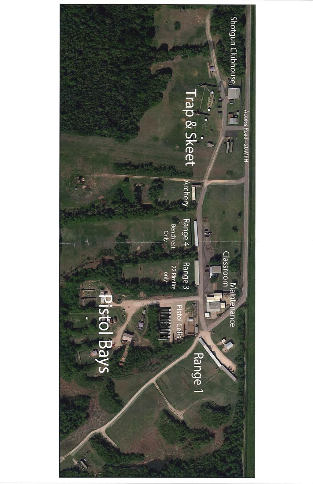
1 Zone Change Request 3099 W. Parkwood Ave. Request to change from Light Industrial (LI) to Light Industrial / Specific Use Permit (LI/SUP) to allow NAICS Use #7139 Other Amusement and Recreation Industries (shooting ranges) This is an existing use that now, according to the Permitted Use Table in the City of Friendswood Zoning Ordinance, requires a Specific Use Permit (SUP). The property owner is proposing to build a new building and two additional structures in the future, which is what triggered the application for the SUP. 1. Rezoning Report 2. Application 3. Metes and Bounds Description 4. Deed 5. Aerial Map 6. Location Map 7. Zoning Map 8. Existing Aerial Site Plan 9. Proposed Site Plan 10. Proposed Building elevations 11. Club House narrative
2 Rezoning Report October 2018 Project: Address: Legal: Request: Zone Change 3099 (3121) W. Parkwood Ave. Being a acre tract, in the Beaty Sealy, and Forwood Survey, Abstract 625, in the I & GN RR Company Survey, Section 23, Abstract 624, Friendswood, Galveston County, Texas. Zone classification change from Light Industrial (LI) to Light Industrial/Specific Use Permit (LI/SUP) to allow NAICS Use 7139 Other Amusement and Recreation Industries (shooting range). Applicable Zoning Ordinance Excerpts Appendix C Zoning Ordinance Section 7. Schedule of District Regulations M. (M-1) LI, Light Industrial District, general purpose and description. The LI, Light Industrial District, is intended primarily for the conduct of light manufacturing, assembling, and fabrication, and for warehousing, wholesaling, and service operations. This district is designed to upgrade industrial development standards, prevent industrial blight, and protect light industrial development from incompatible residential, commercial or heavy industrial uses. Section 9.G. Specific use permits: 1. Purpose. This section provides the city council the opportunity to deny or to conditionally approve those uses for which specific use permits are required. These uses generally have unusual nuisance characteristics or are of a public or semipublic character often essential or desirable for the general convenience and welfare of the community. Because, however, of the nature of the use, the importance of the use's relationship to the comprehensive plan, or possible adverse impact on neighboring properties of the use, review, evaluation, and exercise of planning judgment relative to the location and site plan of the proposed use are required. 5. Conditions for approval. A specific use permit shall be issued only if all of the following conditions have been found: a. That the specific use will be compatible with and not injurious to the use and enjoyment of other property, nor significantly diminish or impair property values within the immediate vicinity; b. That the establishment of the specific use will not impede the normal and orderly development and improvement of surrounding vacant property; c. That adequate utilities, access roads, drainage and other necessary supporting facilities have been or will be provided; d. The design, location and arrangement of all driveways and parking spaces provides for the safe and convenient movement of vehicular and pedestrian traffic without adversely affecting the general public or adjacent developments; e. The adequate nuisance prevention measures have been or will be taken to prevent or control offensive odor, fumes, dust, noise and vibration; f. That directional lighting will be provided so as not to disturb or adversely affect neighboring properties; 1

. Ordinance 2001-06 rezoned the tract to Light Industrial (LI) in 2001.")
3 g. That there are sufficient landscaping and screening to insure harmony and compatibility with adjacent property; and h. That the proposed use is in accordance with the comprehensive plan. 6. Additional conditions. In authorizing a specific use permit, the city council may impose additional reasonable conditions necessary to protect the public interest and welfare of the community. Existing Use/Site Attributes: The site contains multiple buildings and target ranges including a clubhouse, maintenance building, and classroom. A shared, private road provides access to the facility. City of Friendswood GIS Aerial Map Zoning History: The original zoning of the property was Single Family Residential (SFR). Ordinance rezoned the tract to Light Industrial (LI) in Adjacent Zoning/Land Use: The tracts to the north and west of the subject property are zoned Business Park (BP). The properties to the south and east of the subject tract are zoned Light Industrial (LI). City of Friendswood Zoning Map 2
4 Platting Analysis: The property qualifies for a Certificate of Platting Exemption. Planning Analysis: The addition of a new classroom/training facility requires the property to be brought into compliance with the current Zoning Ordinance for building permits to be issued. Comprehensive Planning Analysis: The Future Land Use Map identifies this property developing as Special Interest Non-Residential Light Industrial Emphasis. Infrastructure/Service Delivery Impacts Storm Water Management and Floodplain Issues: The property is eligible to purchase regional detention through the Galveston County Consolidated Drainage District for any additional impervious cover. Utilities: The facility does not have access to city water or sewer. The club currently utilizes water well(s) permitted through the Galveston-Harris Subsidence District and septic system(s) permitted through the Galveston County Health District. Access: The project has direct access to West Parkwood Ave, which in turn connects to FM 518 and out to Interstate 45. Park/Open Space: The property is a commercial development and will not affect the park system. Miscellaneous Codes: Local Government Code, Chapter 229 Miscellaneous Regulatory Authority of Municipalities Local Government Code, Chapter 250 Miscellaneous Regulatory Authority of Municipalities and Counties City of Friendswood Code of Ordinance, Chapter 54 Article IV. Noise 3
5
6 PSC 3099 W. Parkwood Ave. Being a acre tract, in the Beaty Sealy, and Forwood Survey, Abstract 625, in the I&GN RR Company Survey, Section 23, Abstract 624, Friendswood, Galveston County, Texas, and the tract herein being more particularly described by metes and bounds as follows: COMMENCING at a ¾ inch iron pipe set in the East right of way line of State Highway Farm Road # 528 (100 feet wide), and said iron pipe being across said highway and West of a concrete monument set at the Southeast corner of Tower Estates Subdivision; THENCE, North East along and with the South line of said James E. Raines Survey, a distance of feet to an iron rod for corner, being the PLACE OF BEGINNING of the tract herein described; THENCE, North East, continuing along the South line of said James E. Raines Survey, a distance of feet to an iron pipe for corner; THENCE, North East, a distance of feet to an iron rod set in the South line of American Canal Company Easement; THENCE, North West, along and with the South line of said canal easement, a distance of feet to an iron rod for corner; THENCE, South East, a distance of feet to PLACE OF BEGINNING of the tract hereby described. Containing acres, more or less. Recorded in Volume 79 at Page 533 of the Galveston County Deed Records.
7
8
9
10
11
12
13
14
15
16
17
18
19
20 EVERETT DR MOORE RD LUNDY LN Friendswood Sportspark W PARKWOOD AVE SCHULTE LN (PVT) Legend Streets Lot Lines Creeks City Limits Counties City Owned Disclaimer: This product is for informational purposes and may not have been prepared for or be suitable for legal, engineering, or surveying purposes. It does not represent an on-the-ground survey and represents only the approximate relative location of property boundaries. Gov. C The user is encouraged to independently verify all information contained in this product. The City of Friendswood makes no representation or warranty as to the accuracy of this product or to its fitness for a particular purpose. The user: (1) accepts the product AS IS, WITH ALL FAULTS; (2) assumes all responsibility for the use thereof; and (3) releases the City of Friendswood from any damage, loss, or liability arising from such use. City of Friendswood 910 South Friendswood Drive Friendswood, Texas (281) Friendswood GIS Mapping I 1 " = 605 '
21 DIRT RD (PVT) WARE DAIRY RD MOORE RD SURREY LN BRIDLE PATH LN PALMER DR MATCH POINT LN DORADO DR TREVINO CT WIMBLEDON LN LOVE LN COUNTRY CLUB DR LOVE CT EVERETT DR EVERETT DR TAMPA ST W PARKWOOD AVE ORLANDO ST MIAMI CT PENSACOLA LN VAQUERO EL DORADO DR SAN MIGUEL DR EL DORADO DR NILELAKE CT (PVT) LUNDY LN MANDALE RD HOLLIER RD CANAL DR W PARKWOOD AVE SCHULTE LN (PVT) TOWER DR ESTATE DR Legend Streets Lot Lines Creeks City Limits Counties City Owned Disclaimer: This product is for informational purposes and may not have been prepared for or be suitable for legal, engineering, or surveying purposes. It does not represent an on-the-ground survey and represents only the approximate relative location of property boundaries. Gov. C The user is encouraged to independently verify all information contained in this product. The City of Friendswood makes no representation or warranty as to the accuracy of this product or to its fitness for a particular purpose. The user: (1) accepts the product AS IS, WITH ALL FAULTS; (2) assumes all responsibility for the use thereof; and (3) releases the City of Friendswood from any damage, loss, or liability arising from such use. City of Friendswood 910 South Friendswood Drive Friendswood, Texas (281) Friendswood GIS Mapping I 1 " = 1,209 '


 accepts the product AS IS, WITH ALL FAULTS; (2) assumes all responsibility for the use thereof; and (3) releases the City of Friendswood from any damage, loss, or")
22 SFR EVERETT DR SFR , CHURCH SFR MOORE RD LUNDY LN Friendswood Sportspark CSC W PARKWOOD AVE CSC 79-8 SFR SCHULTE LN (PVT) BP LI Legend SFR Streets Lot Lines Creeks City Limits Counties City Owned Special Uses Disclaimer: This product is for informational purposes and may not have been prepared for or be suitable for legal, engineering, or surveying purposes. It does not represent an on-the-ground survey and represents only the approximate relative location of property boundaries. Gov. C The user is encouraged to independently verify all information contained in this product. The City of Friendswood makes no representation or warranty as to the accuracy of this product or to its fitness for a particular purpose. The user: (1) accepts the product AS IS, WITH ALL FAULTS; (2) assumes all responsibility for the use thereof; and (3) releases the City of Friendswood from any damage, loss, or liability arising from such use. City of Friendswood 910 South Friendswood Drive Friendswood, Texas (281) Friendswood GIS Mapping I 1 " = 605 '
23
24
25
26 To Whom it may concern, 10/10/2018 PSC Shooting Club, Inc. proposes to construct a new club house on the north side of our property, just west of the existing buildings. The new structure will be located more than 50 from the existing pipe line right of way. This will be a PEMB structure consisting of a 50 x 60 enclosed area with a 60 x 10 covered patio. The foundation will be concrete construction over select fill. Windstorm rating of 150 mph for Galveston County will be met, for insurance purposes. The roof will be solar white R panels for energy efficiency, and the walls will be light blue R panel to match the existing buildings. All trim to be white. One pair of 7 0 x 6 0 entry doors will be installed along with three 3 0 x 3 0 windows on the front face (south elevation). Walls to be insulated with 3 (R10) vinyl backed and the roof with 6 (R19) vinyl backed material. Men s and Women s restrooms will be included in the project on a septic system. The Club house will have a small residential style kitchen with the remainder of the area to be open and used for a meeting room. The building will be all electric and have LED lighting. The structure will be insulated and airconditioned. The interior will have an acoustic lay in ceiling. All the access will be ADA compliant, and we will provide one ADA parking space and signage. We will add approximately 8100 sq. ft. of parking area. The required parking spaces will be constructed of solid surface material such as concrete or asphalt. The remainder of the parking area will be stabilized crushed concrete. Access to the new building will be from our existing roadways. There are no plans in the project to add any additional site lighting or landscaping. The Club will be petitioning the Galveston County Consolidated Drainage District to purchase detention in lieu of any type of pond.
A variance to exceed the maximum sign height by 3-feet - being a variance from the Sign Ordinance, Appendix A, Section 22.c.(1)
") City of Friendswood Memo To: From: Zoning Board of Adjustment Members Brian Rouane, Building fficial Becky Summers, Development Coordinator Date: August 21, 2018 Subject: 1765 S. Friendswood Drive The
City of Friendswood Memo To: From: Zoning Board of Adjustment Members Brian Rouane, Building fficial Becky Summers, Development Coordinator Date: August 21, 2018 Subject: 1765 S. Friendswood Drive The
ACTION FORM BRYAN CITY COUNCIL
 ACTION FORM BRYAN CITY COUNCIL DATE OF COUNCIL MEETING: July 8, 2014 DATE SUBMITTED: June 17, 2014 DEPARTMENT OF ORIGIN: Development Services SUBMITTED BY: Maggie Dalton MEETING TYPE: CLASSIFICATION: ORDINANCE:
What is a Conditional Use? When is a Conditional Use Necessary? Who decides if I will get a Conditional Use Permit
 What is a Conditional Use? A conditional use is a land use or development that would not be appropriate generally but may be allowed with appropriate controls upon a finding that certain conditions as
ARTICLE B ZONING DISTRICTS
 ARTICLE B ZONING DISTRICTS Sec. 8-3021 Established. In order to protect the character of existing neighborhoods; to prevent excessive density of population in areas which are not adequately served with
INFORMATION & PROCEDURES FOR CHANGE OF ZONING REQUESTS AND CONDITIONAL USE PERMITS
 INFORMATION & PROCEDURES FOR CHANGE OF ZONING REQUESTS AND CONDITIONAL USE PERMITS The applicant is strongly encouraged to attend a pre-application meeting for the project prior to submittal of a zoning
Chapter 2 Land Use. State of Land Use
 Ch2 6/21/2016 1 Chapter 2 Land Use The responsibility of a municipality to manage and regulate land use is rooted in its need to protect the health, safety, and welfare of local citizens. Although only
Understanding the Conditional Use Process
 Understanding the Conditional Use Process The purpose of this document is to explain the process of applying for and obtaining a conditional use permit in the rural unincorporated towns of Dane County.
ZONING AMENDMENT & SUBDIVISION STAFF REPORT Date: July 3, 2014
 ZONING AMENDMENT & SUBDIVISION STAFF REPORT Date: July 3, 2014 APPLICANT NAME SUBDIVISION NAME LOCATION Georgia Crown Distributing Subdivision Georgia Crown Distributing Subdivision Southwest corner of
Planning & Zoning Commission
 Planning & Zoning Commission Planning & Development Department August 14, 01 Zoning Map Amendment MAP-1-0001 (Bay View Section 4) Request Rezone approximately 1.19 acres from OS (Open Space) to RSF- (Residential
SITE PLAN REVIEW ADMINISTRATIVE REVIEW. Please Note: Once submitted to the County, all application materials become a matter of public record.
 200 W. Oak Street, 3rd Floor Fort Collins, CO 80521 (970) 498-7683 / larimer.org/planning SITE PLAN REVIEW ADMINISTRATIVE REVIEW The submittal requirements listed in this packet are intended to collect
Comprehensive Plan 2015 to 2030 STATE OF LAND USE
 Chapter 2 Land Use The responsibility of a municipality to manage and regulate land use is rooted in its need to protect the health, safety, and welfare of local citizens. Although only acting as one section
ARTICLE 14 PLANNED UNIT DEVELOPMENT (PUD) DISTRICT
 DISTRICT") ARTICLE 14 PLANNED UNIT DEVELOPMENT (PUD) DISTRICT Section 14.01 Intent. It is the intent of this Article to allow the use of the planned unit development (PUD) process, as authorized by the Michigan Zoning
ARTICLE 14 PLANNED UNIT DEVELOPMENT (PUD) DISTRICT Section 14.01 Intent. It is the intent of this Article to allow the use of the planned unit development (PUD) process, as authorized by the Michigan Zoning
LAND USE AND ZONING OVERVIEW
 OVERVIEW OF PLANNING POLICIES LAND USE AND ZONING OVERVIEW The Minneapolis Plan for Sustainable Growth and Other Adopted Plans Community Planning and Economic Development Development Services Division
PROPOSED AMENDMENTS TO THE DERBY ZONING REGULATIONS AUGUST 12, 2008
 ARTICLE II Definitions and word usage 195-7. Definitions and word usage. Modify the following: HOUSING FOR THE ELDERLY OLDER PERSONS Housing in accordance with and as defined in the United States Fair
Planning & Zoning Commission
 Zoning Change 13-03 (FM 646) Planning & Zoning Commission Planning & Development Department June 3, 2013 Request Permitted Uses Rezone approximately 24.89 acres of undeveloped land from RSF-7 (Residential
STAFF REPORT. Applicable Statutes/Ordinances: Corinna Township Subdivision Ordinance
 STAFF REPORT Application: Preliminary plat application to subdivide an approximate 6.47 acre parcel into two lots (2.81 and 3.42 acres) with a 0.24 acre remainder to be attached to an existing nonconforming
ARTICLE XI CONDITIONAL USE PERMITS
 ARTICLE XI CONDITIONAL USE PERMITS 11.1 Purpose. The City of Hailey recognizes that certain uses possess unique and special characteristics with respect to their location, design, size, method of operation,
SUBDIVISION, PLANNED UNIT DEVELOPMENT, ZONING AMENDMENT, & SIDEWALK WAIVER STAFF REPORT Date: July 19, 2018
 SUBDIVISION, PLANNED UNIT DEVELOPMENT, ZONING AMENDMENT, & SIDEWALK WAIVER STAFF REPORT Date: July 19, 2018 NAME SUBDIVISION NAME LOCATION West Mobile Properties, LLC U.S. Machine Subdivision 556, 566,
ZONING AMENDMENT & SUBDIVISION STAFF REPORT Date: March 1, 2018
 #13 SUB-000406-2018 & ZON-000407-2018 ZONING AMENDMENT & SUBDIVISION STAFF REPORT Date: March 1, 2018 NAME SUBDIVISION NAME LOCATION Creekside @ Kooiman Dairy Creekside @ Kooiman Dairy Subdivision (South
MTC ALABAMA SUBDIVISION
 # 2 SUB-000370-2017 MTC ALABAMA SUBDIVISION Engineering Comments: FINAL PLAT COMMENTS (should be addressed prior to submitting the FINAL PLAT for review and/or signature by the City Engineer): A. Provide
ZONING AMENDMENT & SUBDIVISION STAFF REPORT Date: July 9, 2015
 ZONING AMENDMENT & SUBDIVISION STAFF REPORT Date: July 9, 2015 APPLICANT NAME 2513 Dauphin Street, Inc. SUBDIVISION NAME Audubon Place Extension No. 3, Resubdivision of Lots 1-5 LOCATION 2513 Dauphin Street
Applications will be received on business days between 9:00 AM and 3:00 PM
 Special Use Permit Application Douglas County Board of Commissioners Douglas County, Georgia Applications will be received on business days between 9:00 AM and 3:00 PM Date of Application: Application
ZONING HEARING BOARD APPLICANTS
 ZONING HEARING BOARD APPLICANTS All applications to the Manheim Township Zoning Hearing Board shall include all of the following information. 1. One (1) application form (no copies needed), signed by the
WASECA PLANNING COMMISSION TUESDAY, FEBRUARY 14, :00 P.M. CITY COUNCIL CHAMBERS 508 SOUTH STATE STREET
 WASECA PLANNING COMMISSION TUESDAY, FEBRUARY 14, 2017 7:00 P.M. CITY COUNCIL CHAMBERS 508 SOUTH STATE STREET Any person speaking to the Commission shall first give to the Recording Secretary of the Commission
VILLAGE OF DOWNERS GROVE PLAN COMMISSION VILLAGE HALL COUNCIL CHAMBERS 801 BURLINGTON AVENUE. June 2, :00 p.m. AGENDA
 VILLAGE OF DOWNERS GROVE PLAN COMMISSION VILLAGE HALL COUNCIL CHAMBERS 801 BURLINGTON AVENUE June 2, 2014 7:00 p.m. AGENDA 1. Call to Order 2. Roll Call a. Pledge of Allegiance 3. Approval of Minutes April
AAAA. Planning and Zoning Staff Report Lake Shore Land Holdings, LLC CU-PH Analysis
 AAAA Planning and Zoning Staff Report Lake Shore Land Holdings, LLC CU-PH2016-28 Hearing Date: April 21, 2016 Development Services Department Applicant: BRS Architects/Cindy Huebert Staff: Kyle McCormick,
(if more than one, give square footage for each) ANNEXATION LOT LINE Adjustments PRE/FINAL PLAT SPECIAL USE PERMIT
 ANNEXATION LOT LINE Adjustments PRE/FINAL PLAT SPECIAL USE PERMIT") Planning Commission Application Building & development office 915 Third ST. Rawlins WY ph. 307-328-4599 fax. 307-328-4590 PROJECT REVIEW: GENERAL INFORMATION Project name: OFFICE USE ONLY Site address
Planning Commission Application Building & development office 915 Third ST. Rawlins WY ph. 307-328-4599 fax. 307-328-4590 PROJECT REVIEW: GENERAL INFORMATION Project name: OFFICE USE ONLY Site address
Jerome Street Mixed Use
 Jerome Street Mixed Use Aerial Site Map 287 N Mason St 1 «Douglas 25 Pinon St _ ^ Vine 287 Mulberry Horsetooth Timberline Drake Lemay Shields Prospect N College Ave 14 U V Taft Hill Mountain Vista Jerome
Planning. the propertyy. Texas Local. Government. Code. size of 2,0000 RSF-2-PUD. Road within the Wharf at a. Citizen. 0 Letter of. 1.
 Planning & Zoning Commissionn Replat Phase I of the Wharf at Clear Lake, Dock 18, Slips 1 and 2 Planning & Development Department February 15, 20166 Request Replat approximately 0.0209 acres of a previouslyy
ZONING AMENDMENT & SUBDIVISION STAFF REPORT Date: June 18, 2015
 ZONING AMENDMENT & SUBDIVISION STAFF REPORT Date: June 18, 2015 APPLICANT NAME SUBDIVISION NAME EAA LLC / Eryka Rogers Aaiden Place Subdivision LOCATION 2480 Government Boulevard (North side of Government
Application for Conditional Use Permit CITY OF VALDOSTA PLANNING AND ZONING DIVISION
 Application for Conditional Use Permit CITY OF VALDOSTA PLANNING AND ZONING DIVISION This is an application for approval of a Conditional Use as listed in the Table of Uses of the Valdosta Land Development
PLANNED UNIT DEVELOPMENT & SUBDIVISION STAFF REPORT Date: April 18, 2019
 PLANNED UNIT DEVELOPMENT & SUBDIVISION STAFF REPORT Date: April 18, 2019 DEVELOPMENT NAME SUBDIVISION NAME Springhill Village Subdivision Springhill Village Subdivision LOCATION 4350, 4354, 4356, 4358,
PLANNED UNIT DEVELOPMENT & SUBDIVISION STAFF REPORT Date: November 17, 2016
 PLANNED UNIT DEVELOPMENT & SUBDIVISION STAFF REPORT Date: November 17, 2016 DEVELOPMENT NAME SUBDIVISION NAME LOCATION Autonation Ford of Mobile Autonation Ford of Mobile Subdivision 901, 909, and 925
CITY OF TYLER CITY COUNCIL COMMUNICATION
 CITY OF TYLER CITY COUNCIL COMMUNICATION Agenda Number: Z-2 Date: January 23, 2019 Subject: PD18-035 FAIR NANCY WOOD (2801 AND 2835 SOUTH BROADWAY AVENUE) Request that the City Council consider approving
ARTICLE 2 ZONING DISTRICTS AND MAPS
 ARTICLE 2 ZONING DISTRICTS AND MAPS SECTION 2.100 PURPOSE OF DISTRICTS Section 2.101. For the purpose of this Ordinance, Billings Township is hereby divided into districts as follows: DISTRICT NAME SYMBOL
{{t:t;r:n;o:"signer 2";l:"Date";}}
 Application/File # Date Application Rec'd: Oct 13 2017 Fee Collected $ (for office use only) CONDITIONAL USE APPLICATION MOTLEY MN Site Address (E-911#): 164 MORRISON STREET WEST 410095000 Lake/River Name:
CITY OF BRIGHTON. Community Development/Planning Department SPECIAL LAND USE APPLICATION
 Date Check # Amount Site Plan # SPECIAL LAND USE APPLICATION Project Address: Petitioner: Petitioner Address: General Information: Property Address: Parcel(s) tax ID number(s): Lot Dimensions: N, E, S,
UPPER MOUNT BETHEL TOWNSHIP NORTHAMPTON COUNTY, PENNSYLVANIA
 UPPER MOUNT BETHEL TOWNSHIP NORTHAMPTON COUNTY, PENNSYLVANIA JOINDER DEED / LOT CONSOLIDATION TOWNSHIP REVIEW PROCESS When accepting proposed Joinder Deeds / Lot Consolidations, review the Joinder Deed
LOCATION MAP: AERIAL PHOTOGRAPH, 2015:
 LOCATION MAP: AERIAL PHOTOGRAPH, 2015: ORDINANCE NO. AN ORDINANCE OF THE CITY OF BRYAN, TEXAS, AMENDING CHAPTER 130, ZONING, OF THE CITY OF BRYAN CODE OF ORDINANCES, BY CHANGING THE ZONING CLASSIFICATION
SUBDIVISION, PLANNED UNIT DEVELOPMENT, PLANNING APPROVAL, ZONING AMENDMENT, & SIDEWALK WAIVER REQUEST STAFF REPORT Date: February 17, 2010
 SUBDIVISION, PLANNED UNIT DEVELOPMENT, PLANNING APPROVAL, ZONING AMENDMENT, & SIDEWALK WAIVER REQUEST STAFF REPORT Date: February 17, 2010 APPLICANT NAME SUBDIVISION NAME DEVELOPMENT NAME LOCATION David
ADMINISTRATIVE HEARING STAFF REPORT
 ADMINISTRATIVE HEARING STAFF REPORT Providence Place Apartments Utility Box No. 2 Conditional Use Petition PLNPCM2011-00426 309 East 100 South September 22, 2011 Planning and Zoning Division Department
Legal Description Part of the Western Half of the Eastern Half of the Northwest Quarter of Section 30, Le Ray Township
 Owner and Applicant s 20448 State Highway 83 Mankato, MN 56001 Request and Location Request for review and approval of a Conditional Use Permit to allow an Elder Care Residential Unit to be constructed
CHAPTER 3 PERMITS, PLANS AND ANNEXATION
 CHAPTER 3 PERMITS, PLANS AND ANNEXATION SECTION: 10-3-1: General Regulations 10-3-2: Building Permit 10-3-3: Plans 10-3-4: Certificate of Compliance and Occupancy 10-3-5: Conditional Use Permits 10-3-6:
Planning Department Oconee County, Georgia
 Planning Department Oconee County, Georgia STAFF REPORT REZONE CASE #: 6985 DATE: October 31, 2016 STAFF REPORT BY: Andrew C. Stern, Planner APPLICANT NAME: Williams & Associates, Land Planners PC PROPERTY
DIVISION 1 PURPOSE OF DISTRICTS
 ARTICLE 2 ZONING DISTRICTS AND MAP DIVISION 1 PURPOSE OF DISTRICTS Section 2.101 Zoning Districts. For the purpose of this Ordinance, the City of Richmond is hereby divided into districts as follows: DISTRICT
ZONING CHANGE/SUP APPLICATION
 ZONING CHANGE/SUP APPLICATION Zoning Change Specific Use Permit Applicant Name: Company: Address: City, State, Zip Phone: Fax: Email: Owner (if different from applicant) Name: Company: Address: City, State,
Appendix A. Definitions
 Definitions 1. Terms Defined. Words contained in this are those having a special meaning relative to the purposes of this Ordinance. Words not listed in this section shall be defined by reference to: (1)
Please complete each entry and check off each item. An incomplete application will be returned.
 CARLTON COUNTY ZONING AND ENVIRONMENTAL SERVICES Permit number 301 Walnut Avenue, Room 103 P.O. Box 220 Carlton, MN 55718-0220 Township 218-384-9176 www.co.carlton.mn.us CONDITIONAL OR INTERIM USE PERMIT
Village of Glenview Plan Commission
 Village of Glenview Plan Commission STAFF REPORT March 24, 2015 TO: Chairman and Plan Commissioners CASE #: P2015-012 FROM: Community Development Department CASE MANAGER: Michelle House, Planner SUBJECT:
City of Valdosta Land Development Regulations
 Chapter 206 Section 206-1 Base Zoning Districts Standards for Uses, Structures, and Property Development (B) (C) Principal Uses and Structures. Principal uses and structures permitted in each base zoning
Introduction. Proposed Land Use and Development Code (LUDC):
:") Introduction The following annotated outline proposes the overall organization and content of the amended Land Use Code (LUC) for the City of Cortez. It is organized in a manner that is intuitive by grouping
Introduction The following annotated outline proposes the overall organization and content of the amended Land Use Code (LUC) for the City of Cortez. It is organized in a manner that is intuitive by grouping
APPLICATION FOR SPECIAL USE PERMIT PLEASE SUBMIT 7 COMPLETE PACKETS
 GOODING COUNTY PLANNING AND ZONING COMMISSION 145 7 TH Avenue East PO Box 417 Gooding, Idaho 83330 Phone: (208) 934-5958 Fax: (208) 934-4363 www.goodingcounty.org/p&z.htm OFFICE USE ONLY: APPLICATION COMPLETE:
2012 COMMUNITY INFORMATION
 2012 COMMUNITY INFORMATION THE HARPER S PRESERVE COMMUNITY ASSOCIATION INC. ( HOA ) HAS PREPARED THIS COURTESY NOTICE OFSUMMARY INFORMATION TO ENCOURAGE THOSE INTERESTED IN HARPER S PRESERVE TO START TO
STAFF REPORT FOR THE CITY OF GOOSE CREEK ZONING BOARD OF APPEALS
 ` STAFF REPORT FOR THE CITY OF GOOSE CREEK ZONING BOARD OF APPEALS For reference, the City of Goose Creek Code of Ordinances are available online at https://www.cityofgoosecreek.com/government/code ordinances
VILLAGE OF MONTGOMERY
 VILLAGE OF MONTGOMERY Plan Commission Meeting Agenda March 3, 2016 7:00 P.M. Village Hall Board Room 200 N. River Street, Montgomery, IL 60538 I. Call to Order II. III. Pledge of Allegiance Roll Call IV.
Individual Well Individual Septic. Community Well 19. What is the proposed method of sewage disposal? Public. None
 Please Answer the Following Questions: (attach sheet if needed). What type of facility is being proposed? Campground Recreational Vehicle (RV) Park Both 2. What is the total acreage of the proposed facility?
Planning Department Oconee County, Georgia STAFF REPORT
 Planning Department Oconee County, Georgia STAFF REPORT REZONE CASE #: 7332 DATE: November 28, 2017 STAFF REPORT BY: Gabriel Quintas, Planner APPLICANT NAME: Smith Planning Group PROPERTY OWNER: John Hadden
APPLICANT NAME SUBDIVISION NAME DEVELOPMENT NAME LOCATION. CITY COUNCIL DISTRICT Council District 4 PRESENT ZONING PROPOSED ZONING
 SUBDIVISION, PLANNED UNIT DEVELOPMENT, PLANNING APPROVAL, ZONING AMENDMENT, & SIDEWALK WAIVER REQUEST STAFF REPORT Date: February 17, 2010 APPLICANT NAME SUBDIVISION NAME DEVELOPMENT NAME LOCATION David
REVISED # Federal Drive Milestones Therapy Project Review for Planning and Zoning Commission
 REVISED #2012-111 394 Federal Drive Milestones Therapy Project Review for Planning and Zoning Commission Meeting Date: November 7, 2012 and November 19, 2012 Request: Location: Acreage: Existing Zoning:
SECTION 4 ZONING DISTRICTS
 SECTION 4 ZONING DISTRICTS Sec. 4-1 Establishment of Districts. In order to protect the character of existing neighborhoods, to prevent excessive density of population in areas which are not adequately
CITY OF NORTH LAS VEGAS MEMORANDUM
 CITY OF NORTH LAS VEGAS MEMORANDUM TO: FROM: SUBJECT: Planning Commission Community Development and Compliance Department # 28 ) AMP-03-15; Coleman Airpark II & III - Comprehensive Plan Amendment (Public
THE AREA PLAN COMMISSION OF ST. JOSEPH COUNTY, IN AGENDA
 THE AREA PLAN COMMISSION OF ST. JOSEPH COUNTY, IN AGENDA Tuesday, January 17, 2017 Fourth-Floor Council Chambers 3:30 p.m. County-City Building, South Bend, IN EXECUTIVE SESSION: A. Election of Officers
May 23, 2017 Staff Report to the Board of Zoning Ad justment. C AS E # VAR I t e m #1. Location Map. Subject
 May 23, 2017 Staff Report to the Board of Zoning Ad justment C AS E # VAR 2 0 1 7-00031 I t e m #1 U N I T E D R E N TA L S O R L A N D O Location Map S U M M A R Y Owner Herbert R. Matthews, Jr. Applicant
Mower County Planning Commission
 Mower County Planning Commission Minutes of the Mower County Planning Commission June 26, 2007 Members Present: Members Absent: Others Present: Tolly Tollefson, Myles Bendtsen, Jim Risius, Margaret Kirchner
Potential Conditions of Approval for Marion County Land Use Decisions
 Potential Conditions of Approval for Marion County Land Use Decisions Planning Division 5155 Silverton Rd. NE Salem OR 97305 Ph. (503) 588-5038; fax (503) 589-3284 http://www.co.marion.or.us/pw/planning
Conditional Use Permit case no. CU 14-06: Bristol Village Partners, LLC
 PLANNING AND ZONING COMMISSION STAFF REPORT August 7, 2014 Conditional Use Permit case no. CU 14-06: Bristol Village Partners, LLC CASE DESCRIPTION: LOCATION: LEGAL DESCRIPTION: EXISTING LAND USE: ZONING:
CURRIE-HALL INVESTMENT CO. BROKERS 77 Milford Road, Suite 274, Hudson, Ohio Akron Cleveland Fax
 CURRIE-HALL INVESTMENT CO. BROKERS 77 Milford Road, Suite 274, Hudson, Ohio 44236 Akron 330-650-0525 Cleveland 330-656-3314 Fax 330-650-0531 A Multi-Tenant Industrial Building For Sale or Lease Office
FENCE PERMIT APPLICATION
 Lake Elmo City Hall 651-747-3900 3800 Laverne Avenue North Lake Elmo, MN 55042 FENCE PERMIT APPLICATION Date: Building Zoning Permit No. Applicant(s): Property Address: PIN Phone Numbers: Email: Comments:
SUBDIVISION & PLANNING APPROVAL STAFF REPORT Date: December 1, 2016
 SUBDIVISION & PLANNING APPROVAL STAFF REPORT Date: December 1, 2016 APPLICANT NAME SUBDIVISION NAME DEVELOPMENT NAME LOCATION Board of Water and Sewer Commissioners of the City of Mobile Halls Mill Road
ARTICLE VII. NONCONFORMITIES. Section 700. Purpose.
 ARTICLE VII. NONCONFORMITIES. Section 700. Purpose. The purpose of this chapter is to regulate and limit the development and continued existence of legal uses, structures, lots, and signs established either
Extractive Industrial Regulatory Ordinance No. 21 revised Dec. 28, 2010 EXTRACTIVE INDUSTRIAL REGULATORY ORDINANCE TYRONE TOWNSHIP, MICHIGAN
 40.101 Sec. 1. TITLE. EXTRACTIVE INDUSTRIAL REGULATORY ORDINANCE TYRONE TOWNSHIP, MICHIGAN ord. no. 21 eff. May 12, 1979, revised Dec. 28, 2010 This ordinance shall be known and cited as the Tyrone Township
Watkinsville First Baptist Church Building and Parking Masterplan Norton Road & Simonton Bridge Road Oconee County Georgia
 Watkinsville First Baptist Church Building and Parking Masterplan Norton Road & Simonton Bridge Road Oconee County Georgia Special Use Approval A-1 CUP to A-1 with Special Use Approval Total Site Area
CHEROKEE COUNTY Application for Public Hearing Special Use Permit
 CHEROKEE COUNTY Application for Public Hearing Special Use Permit Pre-Application Meeting Date: Preliminary Review Meeting Date: Community Information and Input Meeting Date/Time: Applicant, or representative
LAGRANGE TOWNSHIP BOARD OF ZONING APPEALS REQUEST FOR HOME OCCUPATION/CONDITIONAL PERMIT NEW
 LAGRANGE TOWNSHIP BOARD OF ZONING APPEALS REQUEST FOR HOME OCCUPATION/CONDITIONAL PERMIT NEW I AM REQUESTING A CONDITIONAL ZONING PERMIT FOR A HOME OCCUPATION. PRESENT ZONING DISTRICT: DATE: DESCRIPTION
THE CITY OF RAYMORE, MISSOURI Single-Family Residential Zoning Districts
 THE CITY OF RAYMORE, MISSOURI Single-Family Residential Zoning Districts REGULATIONS COMMON TO ALL DISTRICTS: Uses permitted in each district include detached single-family dwellings, manufactured homes
Planning and Zoning Commission Staff Report Shannan & Latrica Mays -Conditional Use Permit - CU
 Planning and Zoning Commission Staff Report Shannan & Latrica Mays -Conditional Use Permit - Hearing Date: January 17, 2019 Development Services Department Applicant: Shannan & Latrica Mays Staff: Jennifer
CHAPTER 1103 REGULATIONS FOR ALL USE DISTRICTS
 CHAPTER 1103 REGULATIONS FOR ALL USE DISTRICTS 1103.01 PURPOSE General regulations apply to all districts. Where requirements of a general regulation and a district regulation differ, the more restrictive
Marion County Board of County Commissioners
 Marion County Board of County Commissioners Date: 12/2/2015 P&Z: 11/30/2015 BCC: 12/16/2015 Item Number 151210SU Type of Application Special Use Permit Request To establish a Clay Electric Co-Operative
City of Ferndale CITY COUNCIL STAFF REPORT
 SUBJECT: Final Plat Approval DATE: January 19, 2016 FROM: Haylie Miller, Assistant Planner PRESENTATION BY: Haylie Miller City of Ferndale CITY COUNCIL STAFF REPORT MEETING DATE: January 19, 2016 AGENDA
Condominium Unit Requirements.
 ARTICLE 19 CONDOMINIUM REGULATIONS Section 19.01 Purpose. The purpose of this Article is to regulate projects that divide real property under a contractual arrangement known as a condominium. New and conversion
PLANNING & DEVELOPMENT
 PLANNING & DEVELOPMENT STAFF REPORT Rezoning PETITION: APPLICANT: PROPERTY OWNER: TYPE OF REQUEST: SIZE OF TRACT: LOCATION: (#17-22) Rezone from A-PUD (Agri-Business Planned Unit Development) to A-PUD
ARTICLE 13 CONDOMINIUM REGULATIONS
 ARTICLE 13 CONDOMINIUM REGULATIONS Section 13.01 Purpose. The purpose of this Article is to regulate projects that divide real property under a contractual arrangement known as a condominium. New and conversion
PLANNING AND ZONING COMMISSION / BOARD OF ADJUSTMENT AGENDA
 PLANNING AND ZONING COMMISSION / BOARD OF ADJUSTMENT AGENDA CITY HALL, COUNCIL CHAMBERS, 5TH FLOOR, 405 6TH STREET, SIOUX CITY, IA May 22, 2018-4:00 P.M. (Said items are on file in Room 308, City Hall,
MINOR PLAT. The following documents are provided as required by the City of Conroe for use in the above titled platting submittals:
 Public Works - Engineering Division CITY OF CONROE MINOR PLAT The following documents are provided as required by the City of Conroe for use in the above titled platting submittals: Submittal Questionnaire
Agenda Information Sheet
 Page 90 Agenda Information Sheet December 13, 2018 Agenda Item Z-18-10 - Conduct a public hearing and consider approval of an ordinance rezoning a 33.4 tract of land out of the H. Teal Survey Abstract
FOR SALE 20,000+/- Square Foot Industrial Building with 4,000+/- square foot Mezzanine
 FOR SALE 20,000+/- Square Foot Industrial Building with 4,000+/- square foot Mezzanine 5135 Holt Boulevard Montclair, California 91763 Contact only Listing Agents below for additional information to Qualified
Estate Home Sites from the 120 s
 FOR SALE ESTATE & EQUESTRIAN HOME SITES THE ESTATES OF GASPARILLA PRESERVE SUNMARK REALTY, INC. PO Box 420 Pineland, Fl 33945 www.sunmarkrealty.net sunmarkrealty@gmail.com Estate Home Sites from the 120
Nassau County CONDITIONAL USE AND VARIANCE BOARD. Sections 3.05, 5.03, 5.04, and 28.14(A) of the Nassau County Land Development Code.
 of the Nassau County Land Development Code.") Nassau County Planning & Economic Development Department 96161 Nassau Place Yulee, FL 32097 (904) 530-6300 (904) 491-3611 FAX cbmason@nassaucountyfl.com BOARD MEMBERS John C. VanDelinder Kathleen Zetterower
Nassau County Planning & Economic Development Department 96161 Nassau Place Yulee, FL 32097 (904) 530-6300 (904) 491-3611 FAX cbmason@nassaucountyfl.com BOARD MEMBERS John C. VanDelinder Kathleen Zetterower
South of White Rock Rezoning Kick-off Meeting
 South of White Rock Rezoning Kick-off Meeting May 6, 2010, 2:00 P.M. American River Room Overview Property owners seeking to restore previous zoning designations City now completing map revisions (north
The Planning Commission. DATE: July 19, 2016
 TO: FROM: The Planning Commission MPC Staff DATE: SUBJECT: Petition of Chatham Savannah Authority for the Homeless Cindy Kelley, Agent Saffold Properties L.P. (John Saffold), Owner Aldermanic District:
Attached is a Clinton Township Zoning Permit Application and requirements for issuance of a permit.
 To Whom It May Concern: Attached is a Clinton Township Zoning Permit Application and requirements for issuance of a permit. The fee for the permit application is $75.00, which shall be made payable to
EXTRA TERRITORIAL ZONING AUTHORITY CASE ANALYSIS
 DOÑA ANA COUNTY CASE # V09-007 COMMUNITY PLANNING AND ECONOMIC DEVELOPMENT DEPARTMENT Building Planning GIS 845 North Motel Boulevard Las Cruces, New Mexico 88007 (575) 647-7350 Fax: (575) 525-6131 Toll
WESTMINSTER PARK SUBDIVISION
 WESTMINSTER PARK SUBDIVISION Engineering Comments: FINAL PLAT COMMENTS (should be addressed prior to submitting the FINAL PLAT for review and/or signature by the City Engineer): A. Provide all of the required
ORDINANCE NO. _4.06 AN ORDINANCE TO ESTABLISH BUILDING SITE REGULATIONS SECTION A PURPOSE AND INTENT
 ORDINANCE NO. _4.06 AN ORDINANCE TO ESTABLISH BUILDING SITE REGULATIONS SECTION A PURPOSE AND INTENT This Ordinance provides minimum regulations, provisions and requirements for safe, aesthetically pleasing
REPORT TO PLANNING & ZONING COMMISSION - CITY OF MARYLAND HEIGHTS
 APPLICATION NUMBER APPLICATION (PROJECT) NAME APPLICANT NAME PROPERTY OWNER NAME CUP16-0003 CENTRAL POWER SYSTEMS & SERVICES, INC. Central Power Systems & Services, Inc. 900 Liberty Drive, Liberty, MO
Planning & Zoning Commission
 Zoning Change Z15-08 (2103 ) Planning & Zoning Commission Planning & Development Department May 18, 2015 Request Applicant /Owner Rezone approximately 2.844 acres of land from OS (Open Space) to RSF-20
ARTICLE 7: PLOT PLANS AND SITE PLAN REQUIREMENTS AND REVIEW
 ARTICLE 7: PLOT PLANS AND SITE PLAN REQUIREMENTS AND REVIEW Section 7.0 - Purpose The purpose of this article is to specify the documents and/or drawings required for a Site Plan Review or a Plot Plan
HOME OCCUPATION SPECIAL USE PERMITS th Street North Stillwater MN
 216 4 th Street North Stillwater MN 55082 651-430-8800 HOME OCCUPATION A Home Occupation is a business or enterprise conducted in a dwelling or accessory dwelling and incidental to the principle residential
CHAPTER 2: ZONING DISTRICTS
 CHAPTER 2: ZONING DISTRICTS 2.1. GENERAL 2.1.1. Purpose To carry out the purpose and provisions of this Code, the County is divided into zoning districts. This chapter establishes the base zoning districts
Innsbruck Val Moritz AFP of Lot 46, Lot 47, & Amended Lot 48 Block 17 Amended Final Plat Adjustment of Interior Lot Lines
 Innsbruck Val Moritz AFP of Lot 46, Lot 47, & Amended Lot 48 Block 17 Amended Final Plat Adjustment of Interior Lot Lines APPLICATION: AMENDED FINAL PLAT HEARING DATES: Planning Commission: 8 November