LARAMIE COUNTY PLANNING & DEVELOPMENT DEPARTMENT
|
|
|
- Jeremy Carson
- 5 years ago
- Views:
Transcription

1 LARAMIE COUNTY PLANNING & DEVELOPMENT DEPARTMENT Planning Building MEMORANDUM TO: FROM: Laramie County Planning Commission Bryan Nicholas, Associate Planner DATE: February 14, 2019 TITLE: Review and action on a Preliminary Development Plan, and a Subdivision Permit and Plat, for Greenwood Subdivision, a replat of Lot 1, Block 1, Busing Addition, Laramie County, WY. EXECUTIVE SUMMARY Steil Surveying Services, on behalf of Garrett Investment LLC, has submitted a Preliminary Development Plan and Subdivision Permit and Plat applications for this property located southwest of the West Prosser Road and Greenwood Place intersection. The application has been submitted to subdivide the property into eleven (11) residential lots: ten (10) lots intended for living units on each proposed lot, with the 11th lot preserving the existing single-family residential use at 417 W. Prosser Rd. BACKGROUND An existing single family residence is located in the north central portion of the property, and will be located on Lot 6 of the proposed subdivision. This subdivision occurs within a mile of the City and requires Governing Body review and approval, and was submitted to the City for approval in December of Pertinent Regulations Section of the Laramie County Land Use Regulations governing the requirements for submittal of a Preliminary Development Plan. Section (a-e) of the Laramie County Land Use Regulations governing the criteria for a subdivision permit and plat. Section of the Laramie County Land Uses Regulations governing the MR Medium Density Residential zone district Archer Pkwy Cheyenne, WY Phone (307) Fax (307) Page 1 of 3
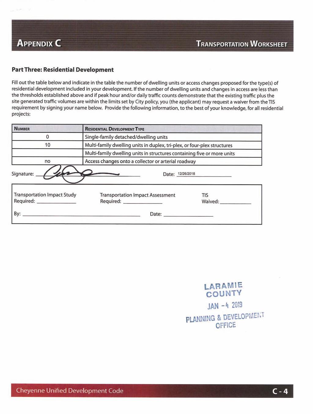
2 DISCUSSION The Laramie County Comprehensive Plan identifies the area as Urban Rural Interface (URI). Within this area, higher density residential, intensive commercial, employment centers and industrial uses are indicated. Generally, these uses have access to public water and sewer services. The subject property is located within the South Cheyenne Water and Sewer District. PlanCheyenne contemplates Urban Residential (UR) uses for this area. This category includes many of the Cheyenne Area s existing neighborhoods, with primary uses including a broader variety of residential types, such as single-family residences, duplexes, patio homes, townhomes, condominiums, and apartments. The subject property is located within the MR Medium Density Residential zone district, in which the proposed duplex development is a Use by Right. The proposed lot sizes on the plat meet the zone district minimum requirements for both single-family and duplex residential uses at 6,000 and 3,000 square feet per unit, respectively. The applicant s intent for development is to construct one structure onto two lots, with the property lines dividing each living unit. This proposed method meets the minimum property area of 3,000 square feet per unit per the MR zone district. As stated above this subject property lies within the South Cheyenne Water and Sewer District, with public services being provided to the existing residence. Pursuant to W.S , subdivisions within a public water/sewer district are exempt from a Wyoming DEQ Chapter 23 Review. Agency review comments were received regarding access spacing from West Prosser Road, fire district requirements for access, premises identification and fire protection, development modeling for public service establishment, and clerical corrections on the plat. Per section of the 2019 Land Use Regulations, a Preliminary Development Plan can be submitted concurrently with a Subdivision Permit and Plat. A letter requesting waiver of the traffic and drainage studies was received with the Subdivision Permit and Plat application, in which the County Engineer has concurred. An Environmental Services Impact Report was not submitted as part of the Preliminary Development Plan application package, and will be required to be submitted to the Planning Office for review prior to the public hearing before the Board on March 5 th. Public notice was provided per Section of the Land Use Regulations. No public comment was received regarding the application. The attached resolution for the Subdivision Permit and Plat shall serve as the subdivision permit upon approval by the Board Archer Pkwy Cheyenne, WY Phone (307) Fax (307) Page 2 of 3
3 RECOMMENDATION and FINDINGS Based on evidence provided for the Preliminary Development Plan, staff recommends the Planning Commission find that: a. This application meets the criteria for a preliminary development plan pursuant to section of the Laramie County Land Use Regulations. Based on evidence provided for the Subdivision Permit and Plat, staff recommends the Planning Commission find that: a. This application meets the criteria for a subdivision permit and plat pursuant to section (a-e) of the Laramie County Land Use Regulations. b. This application is in conformance with section governing the MR Medium Density Residential zone district. and that the Planning Commission recommend approval of the Subdivision Permit and Plat for Greenwood Subdivision to the Laramie County Board of Commissioners with the following condition: 1. Clerical corrections on the plat, per County Engineer/Surveyor comments, shall be addressed prior to the Board public hearing scheduled for March 5, PROPOSED MOTION FOR P.D.P I move to approve the Greenwood Subdivision Preliminary Development Plan and adopt the findings of fact a of the staff report. PROPOSED MOTION FOR THE SUBDIVISION PERMIT & PLAT I move to recommend approval of the Subdivision Permit and Plat for Greenwood Subdivision to the Laramie County Board of Commissioners with condition 1, and adopt the findings of facts a and b of the staff report. ATTACHMENTS Attachment 1: Location Map Attachment 2: Aerial Map Attachment 3: Comprehensive Plan Map Attachment 4: PlanCheyenne Map Attachment 5: Current Zoning Map Attachment 6: Project Narrative / Waiver Requests Attachment 7: Drainage Worksheet Attachment 8: Transportation Worksheet Attachment 9: Agency Comments Report Attachment 10: Draft Resolution Attachment 11: Plat 3966 Archer Pkwy Cheyenne, WY Phone (307) Fax (307) Page 3 of 3
4 DIVISION AVE CEDAR AVE MELODY LN W ALLISON RD E ALLISON RD CONCERTO LN MELODY LN SERENADE DR SONATA L N WALTERSCHEID BLVD DOT RAY PL W ALLISON RD W ALLISON RD S GREELEY HWY E PROSSER RD Laramie County, Wyoming Greenwood Subdivison Sub Permit & Plat PZ Location Map Subject Property LITTLE DITTY LN BALLAD LN SON A TA LN WALTERSCHEID BLVD KAREN PL S GREELEY HWY Property Lines Streets Classification Arterial Collector Local January 2019 W COLLEGE DR CHERRY ST W COLLEGE DR W COLLEGE DR W COLLEGE DR E COLLEGE DR PINE AVE Cheyenne Laramie County GIS Cooperative Feet This map is made possible through the Cheyenne and Laramie County Cooperative GIS Program (CLCCGIS). The data contained herein was collected for its use and is for display and planning purposes only. The CLCCGIS will not be held liable as to the validity, correctness, accuracy, completeness, and/or reliability of the data. The CLCCGIS furthermore assumes no liability associated with the use or misuse of this information.
5 Laramie County, Wyoming Greenwood Subdivison Sub Permit & Plat PZ Aerial Map GREENWOOD PL Streets Subject Property Property Lines Classification Collector Local January 2019 WESTVIEW DR KAREN PL WESTVIEW DR Cheyenne/Laramie County GIS Cooperative Program Feet This map is made possible through the Cheyenne and Laramie County Cooperative GIS Program (CLCCGIS). The data contained herein was collected for its use and is for display and planning purposes only. The CLCCGIS will not be held liable as to the validity, correctness, accuracy, completeness, and/or reliability of the data. The CLCCGIS furthermore assumes no liability associated with the use or misuse of this information.
6 STEPHANIE CT Laramie County, Wyoming Greenwood Subdivison URI WESTVIEW DR WESTVIEW DR GREENWOOD PL Future Land Use Districts OTHER Sub Permit & Plat PZ Comprehensive Plan Map Streets Subject Property Property Lines Classification Collector Local Urban-Rural Interface (URI) Rural Metro (RM) KAREN PL Rural Ag Interface (RAI) Ag & Range Land (AGR) January Cheyenne/Laramie County GIS Cooperative Program Feet This map is made possible through the Cheyenne and Laramie County Cooperative GIS Program (CLCCGIS). The data contained herein was collected for its use and is for display and planning purposes only. The CLCCGIS will not be held liable as to the validity, correctness, accuracy, completeness, and/or reliability of the data. The CLCCGIS furthermore assumes no liability associated with the use or misuse of this information.
7 STEPHANIE CT Laramie County, Wyoming Greenwood Subdivison UR WESTVIEW DR WESTVIEW DR GREENWOOD PL PlanCheyenne (2014) NEW_FLUP Agriculture/Rural OS Rural Residential Urban Transition Residential Urban Residential Mixed-use Residential MU-E Industrial Mixed-use Commercial Community Business Central Business District Public and Quasi-Public PUB-FED Open Space and Parks ROW Sub Permit & Plat PZ PlanCheyenne Map Streets Subject Property Property Lines Classification Collector Local KAREN PL PUB Cheyenne/Laramie County GIS Cooperative Program January Feet This map is made possible through the Cheyenne and Laramie County Cooperative GIS Program (CLCCGIS). The data contained herein was collected for its use and is for display and planning purposes only. The CLCCGIS will not be held liable as to the validity, correctness, accuracy, completeness, and/or reliability of the data. The CLCCGIS furthermore assumes no liability associated with the use or misuse of this information.
8 ZONING LEGEND Zoning Districts All Other Values Archer Special Use District (ASU) Agricultural (A-2) Agricultural and Rural Residental (A-1) Agricultural Residentail (AR) Low Density Residential - Established (LR-1) Low Density Residential - Developing (LR-2) PUD STEPHANIE CT Laramie County, Wyoming MR Medium Density Residential - Established (MR-1) Medium Density Residential - Developing (MR-2) Greenwood Subdivision High Density Residential - Established (HR-1) High Density Residentiial - Developing (HR-2) MU Mixed Use with Residential Emphasis (MUR) Sub Permit & Plat Mixed Use with Business Emphasis (MUB) Neighborhood Business PZ Community Business (CB) Light Industrial (LI) Zoning Map Heavy Industrial (HI) Public (P) Planned Unit Development (PUD) Military (M) GREENWOOD PL SUBJECT PROPERTY MR LEGEND Streets Classification WESTVIEW DR Interstate Arterial Collector Local Platted, Not Built Private KAREN PL Printed on Feb 4, This map is made possible through the Cheyenne and Laramie County Cooperative GIS Program (CLCCGIS). The data contained herein was collected for its use and is for display and planning purposes only. The CLCCGIS will not be held liable as to the validity, correctness, accuracy, completeness, and/or reliability of the data. The CLCCGIS furthermore assumes no liability associated with the use or misuse of this information. Cheyenne/Laramie County GIS Cooperative Program Feet
9
10
11

12
13
14 PZ Greenwood Subdivision Subdivision Permit & Plat Cheyenne MPO: Nancy Olson COMMENTS ATTACHED 01/17/ West Prosser Rd. s functional classification is minor collector. Access spacing per the 2019 Laramie County Land Use Regulations (LCLUR) ( , c., 3. iii, B.) is 150 ft. 2. LCLUR , c., 3. iii, D calls for joint access. It is recommended following this if access spacing is not followed per comment #1 above. County Assessor: Clarice Blanton COMMENTS ATTACHED 01/15/2019 There are existing improvements on the property which appear to be on proposed Lots 6 and 7. County Engineer: Scott Larson COMMENTS ATTACHED 01/21/2019 Engineer Review 1. I concur with the request for waivers of a detailed Traffic Study and Drainage Study based on the information provided. 2. On the Plat Drawing, all of the dates (i.e. year) shown for all signatures show the year They all should be changed to Surveyor Review 1. The ACKNOWLEDGEMENT serves as required documentation to be attached to or reference the DEDICATION and therefore should be placed as near as possible to the DEDICATION. A little rearrangement of the LEGEND and North Arrow would make this possible. 2. In the 3rd line of the ACKNOWLEDGEMENT, THEIR should be HIS. 3. The LEGEND symbols are very difficult to distinguish on the map of the subdivision, making them slightly larger would probably help. 4. There are 5 corner monument symbols in the LEGEND, but there are only 4 types of monuments described. 5. The VICINITY MAP is very small and it is very difficult to read the street names. The SITE arrow barely shows up on the scan provided for review. 6. It would be beneficial to add the Section, Township and Range data, which is required to be shown in the Title Block, to the VICINITY MAP, with enough detail to indicate the location of the subdivision within the Section. County Public Works Department: David Bumann COMMENTS ATTACHED 01/28/2019 W. Prosser road acts as a local street as it does not meet the traffic volumes to be considered a collector at this time. Fire District No. 1: Darrick Mittlestadt COMMENTS ATTACHED 01/16/ IFC Chapter 5 Section 503, Fire Apparatus Access roads, all Section 505, Premises ID, all Section 507, Fire Protection hydrant locations
15 South Cheyenne Water & Sewer: Dena Hansen COMMENTS ATTACHED 01/24/2019 Please contact office for fee schedules and development modeling. Planners: COMMENTS ATTACHED 01/31/19 1. The FEMA 500-year floodplain appears to cover most (if not all) of proposed Lot 1, and portions of proposed Lots 2 and Clerical corrections on the plat, per County Engineer/Surveyor comments, shall be addressed prior to the Board public hearing scheduled for March 5, The City approval signature block on the plat shall be removed. Agencies responding with No Comment: Black Hills Energy, Building Dept. Agencies not responding: County Real Estate Office, County Treasurer, County Conservation District, Laramie County School District No. 1, US Post Office, Combined Communications Center, Emergency Management, Sheriff s Office, South Cheyenne Community Development, Charter Cable Services, Cheyenne Development Services, Cheyenne Urban Planning Office.
16 RESOLUTION NO. A RESOLUTION TO APPROVE A SUBDIVISION PERMIT AND PLAT FOR GREENWOOD SUBDIVISION, A REPLAT OF LOT 1, BLOCK 1, BUSING ADDITION, LARAMIE COUNTY, WY. WHEREAS, Wyoming State Statutes to ; to authorize Laramie County, in promoting the public health, safety, morals and general welfare of the county, to regulate the use of land through zoning in unincorporated Laramie County; and WHEREAS, the Laramie County Board of Commissioners adopted the Laramie County Land Use Regulations; and WHEREAS, the proposed subdivision and plat is in accordance with section (a-e) of the Laramie County Land Use Regulations; and WHEREAS, the application is in conformance with the MR Medium Density Residential zone district; and WHEREAS, this resolution is the subdivision permit for Greenwood Subdivision. NOW THEREFORE BE IT RESOLVED BY THE GOVERNING BODY OF LARAMIE COUNTY, WYOMING, as follows: The Laramie County Board of Commissioners finds that: a. This application is in conformance with section (a-e) of the Laramie County Land Use Regulations. b. This application is in conformance with section governing the MR Medium Density Residential zone district. And the Board approves the Subdivision Permit and Plat for Greenwood Subdivision with the following condition: 1. Clerical corrections on the plat, per County Engineer/Surveyor comments, shall be addressed prior to the Board public hearing scheduled for March 5, PRESENTED, READ AND ADOPTED THIS DAY OF, ATTEST: Debra K. Lee, Laramie County Clerk LARAMIE COUNTY BOARD OF COMMISSIONERS Linda Heath, Chairman Reviewed and approved as to form: Mark T. Voss, Laramie County Attorney
17
LARAMIE COUNTY PLANNING & DEVELOPMENT DEPARTMENT
 LARAMIE COUNTY PLANNING & DEVELOPMENT DEPARTMENT Planning Building MEMORANDUM TO: FROM: Laramie County Planning Commission Nancy M. Trimble, Associate Planner DATE: November 9, 2017 TITLE: Review and action
LARAMIE COUNTY PLANNING & DEVELOPMENT DEPARTMENT
 LARAMIE COUNTY PLANNING & DEVELOPMENT DEPARTMENT Planning Building MEMORANDUM TO: FROM: Laramie County Board of Commissioners Bryan Nicholas, Associate Planner DATE: May 15, 2018 TITLE: Review and action
LARAMIE COUNTY PLANNING & DEVELOPMENT DEPARTMENT
 LARAMIE COUNTY PLANNING & DEVELOPMENT DEPARTMENT Planning Building MEMORANDUM TO: FROM: Laramie County Planning Commission Bryan Nicholas, Associate Planner DATE: November 9, 2017 TITLE: Review and action
LARAMIE COUNTY PLANNING & DEVELOPMENT DEPARTMENT
 LARAMIE COUNTY PLANNING & DEVELOPMENT DEPARTMENT Planning Building MEMORANDUM TO: FROM: Laramie County Board of Commissioners Nancy M. Trimble, Associate Planner DATE: December 5, 2017 TITLE: Review and
LARAMIE COUNTY PLANNING & DEVELOPMENT DEPARTMENT
 LARAMIE COUNTY PLANNING & DEVELOPMENT DEPARTMENT Planning Building MEMORANDUM TO: FROM: Laramie County Planning Commission Nancy M. Trimble, Associate Planner DATE: November 9, 2017 TITLE: Review and action
LARAMIE COUNTY PLANNING & DEVELOPMENT DEPARTMENT
 LARAMIE COUNTY PLANNING & DEVELOPMENT DEPARTMENT Planning Building MEMORANDUM TO: FROM: Laramie County Planning Commission Nancy Trimble, Associate Planner DATE: July 13, 2017 TITLE: Review and action
LARAMIE COUNTY PLANNING & DEVELOPMENT DEPARTMENT
 LARAMIE COUNTY ANNING & DEVELOPMENT DEPARTMENT Planning Building MEMORANDUM TO: FROM: Laramie County Board of Commissioners Seth Frentheway, Associate Planner DATE: June 19 th, 2018 TITLE: Review and action
LARAMIE COUNTY PLANNING & DEVELOPMENT DEPARTMENT
 LARAMIE COUNTY PLANNING & DEVELOPMENT DEPARTMENT Planning Building MEMORANDUM TO: FROM: Laramie County Board of Commissioners Bryan Nicholas, Associate Planner DATE: October 2, 2018 TITLE: Review and action
LARAMIE COUNTY PLANNING & DEVELOPMENT DEPARTMENT
 LARAMIE COUNTY PLANNING & DEVELOPMENT DEPARTMENT Planning Building MEMORANDUM TO: FROM: Laramie County Planning Commission Marissa Pomerleau, Planning Technician DATE: March 28, 2019 TITLE: Review and
LARAMIE COUNTY PLANNING & DEVELOPMENT DEPARTMENT
 LARAMIE COUNTY PLANNING & DEVELOPMENT DEPARTMENT Planning Building MEMORANDUM TO: FROM: Laramie County Planning Commission Bryan Nicholas, Associate Planner DATE: April 11, 2019 TITLE: Review and action
LARAMIE COUNTY PLANNING & DEVELOPMENT DEPARTMENT
 LARAMIE COUNTY PLANNING & DEVELOPMENT DEPARTMENT Planning Building MEMORANDUM TO: FROM: Laramie County Board of Commissioners Brad Emmons, Planning Director DATE: May 15, 2018 TITLE: Review and action
LARAMIE COUNTY PLANNING & DEVELOPMENT DEPARTMENT
 LARAMIE COUNTY PLANNING & DEPARTMENT Planning Building MEMORANDUM TO: FROM: Laramie County Planning Commission Nancy M. Trimble, Associate Planner DATE: December 14, 2017 TITLE: Review and action of a
LARAMIE COUNTY PLANNING & DEVELOPMENT DEPARTMENT
 LARAMIE COUNTY PLANNING & DEVELOPMENT DEPARTMENT Planning Building MEMORANDUM TO: FROM: Laramie County Planning Commission Brad Emmons, Planning Director DATE: March 22, 2018 TITLE: Review and recommendations
LARAMIE COUNTY PLANNING & DEVELOPMENT DEPARTMENT
 LARAMIE COUNTY PLANNING & DEVELOPMENT DEPARTMENT Planning Building MEMORANDUM TO: FROM: Laramie County Planning Commission Seth Frentheway, Associate Planner DATE: August 23, 2018 TITLE: Review and action
LARAMIE COUNTY PLANNING & DEVELOPMENT DEPARTMENT
 LARAMIE COUNTY PLANNING & DEVELOPMENT DEPARTMENT Planning Building MEMORANDUM TO: FROM: Laramie County Planning Commission Nancy M. Trimble, Associate Planner DATE: July 13, 2017 TITLE: Review and action
LARAMIE COUNTY PLANNING & DEVELOPMENT DEPARTMENT
 LARAMIE COUNTY PLANNING & DEVELOPMENT DEPARTMENT Planning Building MEMORANDUM TO: FROM: Laramie County Planning Commission Brett Walker, Planner DATE: January 25, 2018 TITLE: Review and action of a Subdivision
LARAMIE COUNTY PLANNING & DEVELOPMENT DEPARTMENT
 LARAMIE COUNTY PLANNING & DEVELOPMENT DEPARTMENT Planning Building MEMORANDUM TO: FROM: Laramie County Planning Commission Seth Frentheway, Associate Planner DATE: August 23, 2018 TITLE: Review and recommendations
LARAMIE COUNTY PLANNING & DEVELOPMENT DEPARTMENT
 LARAMIE COUNTY PLANNING & DEVELOPMENT DEPARTMENT Planning Building MEMORANDUM TO: FROM: Laramie County Planning Commission Jean Vetter, Senior Planner DATE: January 26, 2017 TITLE: Review and action of
LARAMIE COUNTY PLANNING & DEVELOPMENT DEPARTMENT
 LARAMIE COUNTY PLANNING & DEVELOPMENT DEPARTMENT Planning Building MEMORANDUM TO: FROM: Laramie County Planning Commission Brett Walker, Planner DATE: January 25, 2018 TITLE: Review and action of a Variance
LARAMIE COUNTY PLANNING & DEVELOPMENT DEPARTMENT
 LARAMIE COUNTY PLANNING & DEVELOPMENT DEPARTMENT Planning Building MEMORANDUM TO: FROM: Laramie County Planning Commission Seth Frentheway, Associate Planner DATE: November 8, 2018 TITLE: Review and action
LARAMIE COUNTY PLANNING & DEVELOPMENT DEPARTMENT
 LARAMIE COUNTY PLANNING & DEVELOPMENT DEPARTMENT Planning Building MEMORANDUM TO: FROM: Laramie County Board of Commissioners Nancy Trimble, Associate Planner DATE: July 18, 2017 TITLE: Review and action
LARAMIE COUNTY PLANNING & DEVELOPMENT DEPARTMENT
 LARAMIE COUNTY PLANNING & DEVELOPMENT DEPARTMENT Planning Building MEMORANDUM TO: FROM: Laramie County Planning Commission Bryan Nicholas, Associate Planner DATE: September 27, 2018 TITLE: Review and action
LARAMIE COUNTY PLANNING & DEVELOPMENT DEPARTMENT
 LARAMIE COUNTY PLANNING & DEVELOPMENT DEPARTMENT Planning Building MEMORANDUM TO: FROM: Laramie County Board of Commissioners Bryan Nicholas, Associate Planner DATE: October 16, 2018 TITLE: Review and
ORDINANCE NO. BE IT ORDAINED BY THE GOVERNING BODY OF THE CITY OF CHEYENNE, WYOMING: That the City of Cheyenne hereby finds as follows:
 ORDINANCE NO. ENTITLED: AN ORDINANCE ANNEXING TO THE CITY OF CHEYENNE, WYOMING, A PARCEL OF LAND SITUATED IN THE NORTH 102 FEET OF TRACTS 323 AND 324, SUNNYSIDE ADDITION, 7TH FILING, LARAMIE COUNTY, WYOMING
STAFF REPORT - SUMMATION. Saddle Ridge, 7 th Filing. Preliminary Plat Process CASE NUMBER: UDC SUBDIVISION CODE: SDRA-P
 STAFF REPORT - SUMMATION Saddle Ridge, 7 th Filing Preliminary Plat Process CASE NUMBER: UDC-15-00351 SUBDIVISION CODE: SDRA-P PREPARED BY: MEETING DATES: Josh Tetzlaff July 6, 2015 Planning Commission
Minutes of the Proceedings Laramie County Planning Commission Prepared by the Laramie County Planning & Development Office Laramie County Wyoming
 Minutes of the Proceedings Laramie County Planning Commission Prepared by the Laramie County Planning & Development Office Laramie County Wyoming Thursday, January 12, 2012 120112 00 The Laramie County
BE IT ORDAINED BY THE GOVERNING BODY OF THE CITY OF CHEYENNE, WYOMING: FIRST READING: SECOND READING: 3RD AND FINAL READING:
 ORDINANCE NO. ENTITLED: AN ORDINANCE PURSUANT TO SECTION 2.2.1 ZONING MAP AMENDMENTS, SECTION 5.1.2 ZONING DISTRICTS ESTABLISHED, AND SECTION 5.1.3 OFFICIAL ZONING MAP, OF THE UNIFIED DEVELOPMENT CODE,
Minutes of the Proceedings Laramie County Planning Commission Prepared by the Laramie County Planning & Development Office Laramie County Wyoming
 Minutes of the Proceedings Laramie County Planning Commission Prepared by the Laramie County Planning & Development Office Laramie County Wyoming Thursday, April 10, 2014 140410 00 The Laramie County Planning
ORDINANCE NO. BE IT ORDAINED BY THE GOVERNING BODY OF THE CITY OF CHEYENNE, WYOMING:
 ORDINANCE NO. ENTITLED: AN ORDINANCE PURSUANT TO SECTION 2.2.1, ZONING MAP AMENDMENT, 2.2.2, PLANNED DEVELOPMENT REGULATING PLAN OR DEVELOPMENT MASTER PLAN, SECTION 5.1.2, ZONING DISTRICTS ESTABLISHED,
MINUTES OF THE TOWN OF LADY LAKE REGULAR PLANNING AND ZONING BOARD MEETING LADY LAKE, FLORIDA. May 8, :30 p.m.
 MINUTES OF THE TOWN OF LADY LAKE REGULAR PLANNING AND ZONING BOARD MEETING LADY LAKE, FLORIDA May 8, 2017 5:30 p.m. The Planning and Zoning Board Meeting was held in the Town Hall Commission Chambers at
Marion County Board of County Commissioners
 Marion County Board of County Commissioners Date: 12/2/25 P&Z: 11/30/25 BCC: 12/16/25 Amendment No: (20)151209Z Type of Application Rezoning Request P-MH (Mobile Home Park) to B-2 (Community Business)
ZONING VARIANCES - ADMINISTRATIVE
 Planning Department 200 W. Oak Street 3 rd Floor Fort Collins, CO 80521 970-498-7683 www.larimer.org/planning ZONING VARIANCES - ADMINISTRATIVE The submittal requirements listed in this packet are intended
B. The proposed parcel(s) of land shall be in compliance with the current zoning requirements.
 of land shall be in compliance with the current zoning requirements.") SECTION 14-900 SUBDIVISION EXEMPTION 14-901 INTENT To establish criteria and a review process whereby the Board of County Commissioners may grant Exemptions from the definition of the terms subdivision
SECTION 14-900 SUBDIVISION EXEMPTION 14-901 INTENT To establish criteria and a review process whereby the Board of County Commissioners may grant Exemptions from the definition of the terms subdivision
CERTIFICATION OF THE APPROVAL OF WATER AND SEWERAGE SYSTEMS
 ARTICLE 9 FORMS AND CHECK LISTS 9.100 On preliminary layout & final subdivision plat CERTIFICATION OF THE APPROVAL OF WATER AND SEWERAGE SYSTEMS I hereby certify that the (...type: private or pubic...)
Whitney Ranch, 1 st Filing Annexation UDC P a g e 1
 STAFF REPORT - SUMMATION Whitney Ranch, 1 st Filing Annexation CASE NUMBER: UDC-17-00689 SUBDIVISION CODE: HIH 01 PREPARED BY: Eric Hammer PROPOSED CODE: WTRH 01 MEETING DATES: January 2, 2018 Planning
SUBDIVISION APPLICATION (CHECK THE BOX THAT APPLIES)
") GARFIELD COUNTY Building & Planning Department 108 8 th Street, Suite 401 Glenwood Springs, Colorado 81601 Telephone: 970.945.8212 Facsimile: 970.384.3470 www.garfield-county.com SUBDIVISION APPLICATION
GARFIELD COUNTY Building & Planning Department 108 8 th Street, Suite 401 Glenwood Springs, Colorado 81601 Telephone: 970.945.8212 Facsimile: 970.384.3470 www.garfield-county.com SUBDIVISION APPLICATION
AGENDA ITEM SUMMARY BUSINESS OF THE CITY COUNCIL CITY OF GOLDEN, COLORADO. Quasi Judicial Matter
 AGENDA ITEM SUMMARY BUSINESS OF THE CITY COUNCIL CITY OF GOLDEN, COLORADO Quasi Judicial Matter MEETING DATE: July 10, 2014 REPORT DATE: June 30, 2014 CASE NO: PC 14-26 DEPT. OF ORIGIN: Community and Economic
LARAMIE COUNTY PLANNING & DEVELOPMENT DEPARTMENT
 LARAMIE COUNTY PLANNING & DEVELOPMENT DEPARTMENT Planning Building MEMORANDUM TO: FROM: Laramie County Board of Commissioners Brett Walker, Planner DATE: April 3, 2018 TITLE: Review and action of a PUD
Plans shall be drawn at a readable scale, signed, and sealed by a Florida Registered Engineer. The application package shall include:
 CHAPTER 400. SECTION 403. PERMIT TYPES AND APPLICATIONS SITE DEVELOPMENT 403.3. Preliminary Site Plans (PSP) A. Intent and Purpose PSPs are used to identify existing site conditions and demonstrate general
ZONING VARIANCES ADMINISTRATIVE
 200 W. Oak Street, 3rd Floor Fort Collins, CO 80521 (970) 498-7683 / larimer.org/planning ZONING VARIANCES ADMINISTRATIVE The submittal requirements listed in this packet are intended to collect all of
TO: Glynn County Islands Planning Commission. Karl W. Bursa, AICP, Planner II. PP3105 Stillwater Phase III. DATE: November 10, 2015
 COMMUNITY DEVELOPMENT DEPARTMENT Planning and Zoning Division 1725 Reynolds Street, Suite 200, Brunswick, GA 31520 Phone: 912-554-7428/Fax: 1-888-252-3726 TO: Glynn County Islands Planning Commission FROM:
DOÑA ANA COUNTY PLANNING AND ZONNING COMMISSION
 DOÑA ANA COUNTY PLANNING AND ZONNING COMMISSION Doña Ana County Government Complex 845 N. Motel Blvd. Las Cruces, New Mexico 88007 Office: (575) 647-7350 MEETING DATE: June 22, 2017 REQUEST: Variance CASE
MAJOR RESIDENTIAL AND NONRESIDENTIAL SUBDIVISIONS
 Lawrence-Douglas County MAJOR RESIDENTIAL AND NONRESIDENTIAL SUBDIVISIONS Preliminary Plats The applicant shall schedule a Pre-Application meeting with Planning Staff at least seven (7) working days prior
CITY OF PAPILLION MAYOR AND CITY COUNCIL REPORT APRIL 3, 2018 AGENDA. Subject: Type: Submitted By: Resolution #R
 CITY OF PAPILLION MAYOR AND CITY COUNCIL REPORT APRIL 3, 2018 AGENDA Subject: Type: Submitted By: A request for a Final Plat for the property legally described as Tax Lot 3 located in the NE 1/4 of the
Board Summary Report
 Board of County Commissioners: Public Hearing Agenda, August 7, 2018 Agenda Item: # Date: July 25, 2018 To: Through: From: Subject: Board of County Commissioners Jan Yeckes, Planning Division Manager Bill
Planning & Zoning Commission
 Planning & Zoning Commission Planning & Development Department August 14, 01 Zoning Map Amendment MAP-1-0001 (Bay View Section 4) Request Rezone approximately 1.19 acres from OS (Open Space) to RSF- (Residential
MUNICIPAL BUILDING 2101 O Neil Avenue Cheyenne, WY
 MUNICIPAL BUILDING 2101 O Neil Avenue Cheyenne, WY 82001 http://www.cheyennecity.org To view agenda backup items select the following link: http://cheyenne.granicus.com/generatedagendaviewer.php?view_id=5&event_id=687
Staff Report: Date: Applicant: Property Identification: Acreage of Request: Current Zoning of Requested Area: Requested Action: Attached:
 Staff Report: Completed by Jeff Palmer Director of Planning & Zoning Date: November 7, 2018, Updated November 20, 2018 Applicant: Greg Smith, Oberer Land Developer agent for Ronald Montgomery ET AL Property
Marion County Board of County Commissioners
 Marion County Board of County Commissioners Date: 4/26/26 P&Z: 4/25/26 BCC: 5/17/26 Item Number 160509Z Type of Application Request to rezone the property from the Rural Commercial (RC-1) District to the
REGULAR PLANNING COMMISSION MEETING FOR OCTOBER 26, 2016, 6:00 PM
 Archuleta County Development Services Department ARCHULETA COUNTY PLANNING COMMISSION AGENDA County Commissioners Meeting Room, 398 Lewis Street Public is welcome and encouraged to attend. REGULAR PLANNING
Marion County Board of County Commissioners
 Marion County Board of County Commissioners Date: 6/4/217 P&Z: 9/25/217 BCC Transmittal: 1/17/217 BCC Adopt: TBD Amendment No: 217-L6 Type of Application Large-Scale Comp Plan Amendment Request: Change
Guide to Replats. Step 1. Step 2. Step 3. Step 4. Step 5. Step 6. Step 7. Step 8. Step 9. Step 10
 Guide to Replats Introduction Douglas County is committed to providing open, transparent application processes to the public. This Guide is provided to assist anyone interested in the procedures and expectations
Subject: Ordinance 1657, Annexation of 3.55 acres of land at 3015 and 3001 Parker Road.
 Agenda Report 2016-12-12-09 Date: December 8, 2016 To: From: Russ Axelrod, Mayor Members, West Linn City Council Jennifer Arnold, Planning Department Through: John Boyd, Interim Community Development Director
BOARD OF COUNTY COMMISSIONERS ARCHULETA COUNTY, COLORADO RESOLUTION 2018-
 BOARD OF COUNTY COMMISSIONERS ARCHULETA COUNTY, COLORADO RESOLUTION 2018- ARCHULETA COUNTY IMPROPERLY DIVIDED PARCELS EXEMPTION INTERIM RESOLUTION - A RESOLUTION ADDRESSING PARCELS UNDER THE SIZE OF 35
Board of County Commissioners Agenda Request
 Board of County Commissioners Agenda Request Date of Meeting: March 26, 2019 Date Submitted: March 19, 2019 To: From: Agenda Location: Subject: Honorable Chairman and Members of the Board Margaret Emblidge,
HENDRY COUNTY PLANNING & ZONING DEPARTMENT POST OFFICE BOX S. MAIN STREET LABELLE, FLORIDA (863) FAX: (863)
 FAX: (863)") HENDRY COUNTY PLANNING & ZONING DEPARTMENT POST OFFICE BOX 2340 640 S. MAIN STREET LABELLE, FLORIDA 33975 (863) 675-5240 FAX: (863) 674-4194 STAFF REPORT CPA19-0001 Comprehensive Plan Map Amendment Local
HENDRY COUNTY PLANNING & ZONING DEPARTMENT POST OFFICE BOX 2340 640 S. MAIN STREET LABELLE, FLORIDA 33975 (863) 675-5240 FAX: (863) 674-4194 STAFF REPORT CPA19-0001 Comprehensive Plan Map Amendment Local
Guide to Preliminary Plans
 Guide to Preliminary Plans Introduction The Douglas County is committed to providing open, transparent application processes to the public. This Guide is provided to assist anyone interested in the procedures
SUBDIVISION, PLANNING APPROVAL, & REZONING STAFF REPORT Date: June 4, 2015
 SUBDIVISION, PLANNING APPROVAL, & REZONING STAFF REPORT Date: June 4, 2015 APPLICANT NAME SUBDIVISION NAME DEVELOPMENT NAME LOCATION Board of Water & Sewer Commissioners of the City of Mobile MAWSS MLK
DRAFT Subject to Modifications
 TREASURE COAST REGIONAL PLANNING COUNCIL M E M O R A N D U M DRAFT Subject to Modifications To: Council Members AGENDA ITEM 5L From: Date: Subject: Staff September 17, 2010 Council Meeting Local Government
Oakland County Michigan Register of Deeds Plat Engineering, GIS, & Remonumentation Dept. Ph: (248) Fax (248)
 Fax (248)") Oakland County Michigan Register of Deeds Plat Engineering, GIS, & Remonumentation Dept. Ph: (248)-858-1447 Fax (248)-858-7466 Requirements Needed for Final Plat Approval No. General Requirements. 1 Routing
Oakland County Michigan Register of Deeds Plat Engineering, GIS, & Remonumentation Dept. Ph: (248)-858-1447 Fax (248)-858-7466 Requirements Needed for Final Plat Approval No. General Requirements. 1 Routing
City of Leavenworth DEPARTMENT OF DEVELOPMENT SERVICES MAJOR SUBDIVISION APPLICATION 1
 Proposed Name of Subdivision: City of Leavenworth DEPARTMENT OF DEVELOPMENT SERVICES MAJOR SUBDIVISION APPLICATION 1 FOR PRELIMINARY SUBDIVISION APPROVAL This application must be filled out legibly, in
(if more than one, give square footage for each) ANNEXATION LOT LINE Adjustments PRE/FINAL PLAT SPECIAL USE PERMIT
 ANNEXATION LOT LINE Adjustments PRE/FINAL PLAT SPECIAL USE PERMIT") Planning Commission Application Building & development office 915 Third ST. Rawlins WY ph. 307-328-4599 fax. 307-328-4590 PROJECT REVIEW: GENERAL INFORMATION Project name: OFFICE USE ONLY Site address
Planning Commission Application Building & development office 915 Third ST. Rawlins WY ph. 307-328-4599 fax. 307-328-4590 PROJECT REVIEW: GENERAL INFORMATION Project name: OFFICE USE ONLY Site address
SITE PLAN REVIEW ADMINISTRATIVE REVIEW. Please Note: Once submitted to the County, all application materials become a matter of public record.
 200 W. Oak Street, 3rd Floor Fort Collins, CO 80521 (970) 498-7683 / larimer.org/planning SITE PLAN REVIEW ADMINISTRATIVE REVIEW The submittal requirements listed in this packet are intended to collect
DAUPHIN CREEK ESTATES SUBDIVISION
 # 12 SUB-000076-2017 DAUPHIN CREEK ESTATES SUBDIVISION Engineering Comments: FINAL PLAT COMMENTS (should be addressed prior to submitting the FINAL PLAT for review and/or signature by the City Engineer):
Planning Commission Application Summary
 Planning Commission Application Summary Project Name: Creekside Estates Zone Change and Land Use Amendment Address: 571 West 11400 South Current Zoning: RA1 Hearing Date: July 14, 2016 Summary of Request
RESOLUTION NO. R2010-
 RESOLUTION NO. R2010- A RESOLUTION OF THE CITY OF MANTECA CITY COUNCIL AUTHORIZING SUBMITTAL OF APPLICATION TO THE SAN JOAQUIN LOCAL AGENCY FORMATION COMMISSION IN THE MATTER OF REORGANIZATION, INCLUDING
April 19, Planning and Land Development Regulation Commission (PLDRC)
") Page 1 of 15 GROWTH AND RESOURCE MANAGEMENT DEPARTMENT PLANNING AND DEVELOPMENT SERVICES DIVISION 123 W. Indiana Avenue, DeLand, FL 32720 (386) 736-5959 PLDRC HEARING: CASE NO: SUBJECT: LOCATION: APPLICANT:
Page 1 of 15 GROWTH AND RESOURCE MANAGEMENT DEPARTMENT PLANNING AND DEVELOPMENT SERVICES DIVISION 123 W. Indiana Avenue, DeLand, FL 32720 (386) 736-5959 PLDRC HEARING: CASE NO: SUBJECT: LOCATION: APPLICANT:
CITY OF ALTAMONTE SPRINGS
 CITY OF ALTAMONTE SPRINGS SUBDIVISION PLAT DRC REVIEW APPLICATION SUBMITTAL SUFFICIENCY CHECKLIST Note that a pre-submittal sufficiency review is mandatory. If your project also includes a site plan, your
APPLICATION FOR A BUILDING PERMIT (To be completed by applicant) (Please Print or Type)
 (Please Print or Type)") CARBON COUNTY Department of Planning and Development Application Fee $: 215 West Buffalo, Suite 336 Check #: Rawlins, WY 82301 Receipt #: Tel (307) 328-2651 FAX (307) 328-2735 Permit #: Date Issued: www.carbonwy.com
CARBON COUNTY Department of Planning and Development Application Fee $: 215 West Buffalo, Suite 336 Check #: Rawlins, WY 82301 Receipt #: Tel (307) 328-2651 FAX (307) 328-2735 Permit #: Date Issued: www.carbonwy.com
FINAL PLAT APPLICATION
 FINAL PLAT APPLICATION (Page 1 of 3) LEGAL OWNER(s): NAME: STREET ADDRESS OWNER(s): CITY, STATE, ZIP CODE: PHONE NUMBER: BILLING ADDRESS: NAME OF ENGINEER/SURVEYOR: Engineer/Surveyor Address, Phone: PROPERTY
Marion County Planning & Zoning Commission
 Marion County Planning & Zoning Commission Date: /3/24 P&Z: 9/29/24 BCC: /21/24 Item Number 1409Z Type of Application Rezoning Request From: R-3, Multiple Family Residential To: B-4, Regional Business
SUBDIVISION REGULATIONS
 CHAPTER 14 SUBDIVISION REGULATIONS 14-100 Provisions 14-200 Preliminary Plat 14-300 Final Plat 14-400 Replat 14-500 Minor Subdivision 14-600 Administrative Replat 14-700 Vacation of Roadways, Public Easements,
PLANNED UNIT DEVELOPMENT & SUBDIVISION STAFF REPORT Date: September 15, 2016
 # 10 SUB2016-00089 PLANNED UNIT DEVELOPMENT & SUBDIVISION STAFF REPORT Date: September 15, 2016 NAME SUBDIVISION NAME LOCATION Lot 12 Laughlin Industrial Park Subdivision Lot 12 Laughlin Industrial Park
Walton County Planning and Development Services
 Walton County Planning and Development Services 31 Coastal Centre Boulevard, Suite 100 47 N 6 th Street Santa Rosa Beach, Florida 32459 DeFuniak Springs, Florida 32433 Phone 850-267-1955 Phone 850-892-8157
Preliminary Plat/Final Plat Application
 Melissa Municipal Center 3411 Barker Avenue Melissa, Texas 75454 Phone: (972) 838-2036 Applicant: Date: Address: Phone: Contact: Fax: E-mail: Propose Addition Name: Acres: Existing Zoning: Propose Zoning:
MINOR PLAT FILING APPLICATION
 FILING APPLICATION Date of PC Meeting: Date of BCC Meeting: Fee Paid: 1. APPLICANT: DAYTIME PHONE: MAILING ADDRESS: LANDOWNER: DAYTIME PHONE: MAILING ADDRESS: AUTHORIZED AGENT: MAILING ADDRESS: RELATIONSHIP
Staff Report: Date: Applicant: Property Identification: Acreage of Request: Current Zoning of Requested Area: Requested Action: Attached:
 Staff Report: Completed by Jeff Palmer Director of Planning & Zoning Date: November 7, 2018 Applicant: Greg Smith, Oberer Land Developer agent for Ronald Montgomery ET AL Property Identification: Frontage
, Assistant County Attorney. when the following proceedings, among others were had and done, to-wit: RESOLUTION NO.
 STATE OF COLORADO ) )ss County of Garfield ) At a regular meeting of the Board of County Commissioners for Garfield County, Colorado, held in the Commissioners' Meeting Room, Garfield County Administration
APPLICATION FOR PRELIMINARY PLAT RESIDENTAIL. FILING FEE: $ for the first 20 lots; $10.00 for each additional lot over 20
 COMMUNITY PLANNING & DEVELOPMENT TELEPHONE.* (816) 331-4331 FAX * (816) 331-6973 CITY HALL ANNEX 520 MAIN STREET BELTON, MISSOURI 64012 WEBSITE * www.belton.org APPLICATION FOR PRELIMINARY PLAT RESIDENTAIL
Watertown City Council
 City of Watertown Watertown City Council 2/14/2017 Agenda Item: Riverpointe Subdivision 2 nd Replat Request for Action: Sketch Plan Department: Planning Request for Action Request: Paxmar, LLC (Applicant)
Residential Minor Subdivision Review Checklist
 Residential Minor Subdivision Review Checklist Plan Submittal Requirements: 2 full sets of stamped plans Electric submittal - all plans contained in a single PDF 3 full sets if commercial kitchen or dining
Description of Zoning Resolution Amendment: (attach additional sheets if necessary)
") CARBON COUNTY www.carbonwy.com Department of Planning and Development 215 West Buffalo, Suite 336 Application Fee $200.00 (plus public notice cost) Rawlins, WY 82301 Fee Paid $ Date Tel (307) 328-2651
CARBON COUNTY www.carbonwy.com Department of Planning and Development 215 West Buffalo, Suite 336 Application Fee $200.00 (plus public notice cost) Rawlins, WY 82301 Fee Paid $ Date Tel (307) 328-2651
Parcel Map Review Committee Staff Report Meeting Date: October 13, 2016
 Subject: Applicant: Agenda Item Number: Project Summary: Recommendation: Parcel Map Review Committee Staff Report Meeting Date: October 13, 2016 Parcel Map Case Number Spanish Springs Associates Ltd. Ptsp.
APPLICATION FOR SUBDIVISION APPROVAL OF A SKETCH PLAN with checklist
 Prior to filing any application for SUBDIVISION approval, the applicant shall request in writing that the zoning administrator schedule a pre-submission conference. APPLICATION TO THE PLANNING BOARD TOWN
CITY OF PAPILLION PLANNING COMMISSION STAFF REPORT MAY 27, 2015 AGENDA REVISE ZONING MAP MISC
 PLANNING COMMISSION STAFF REPORT MAY 27, 2015 AGENDA REVISE ZONING MAP MISC-15-0006 I. GENERAL INFORMATION A. APPLICANT: City of Papillion 122 East Third St. Papillion, NE 68046 B. REQUESTED ACTION: Approval
LOCATION MAP: AERIAL PHOTOGRAPH, 2015:
 LOCATION MAP: AERIAL PHOTOGRAPH, 2015: ORDINANCE NO. AN ORDINANCE OF THE CITY OF BRYAN, TEXAS, AMENDING CHAPTER 130, ZONING, OF THE CITY OF BRYAN CODE OF ORDINANCES, BY CHANGING THE ZONING CLASSIFICATION
Application for Preliminary Plat Checklist
 Application for Preliminary Plat Checklist Note: No portion of an existing parcel may be sold or transferred to another party without first legally subdividing the property according to the City of Richmond
Guide to Minor Developments
 Guide to Minor Developments Introduction The Douglas County (DCD) is committed to providing open, transparent application processes to the public. This Guide is provided to assist anyone interested in
The Laramie County Land Use Regulations
 LARAMIE COUNTY, WYOMING Formatted The Laramie County Land Use Regulations Title 2 County-Wide Land use Regulations 5/24/2018 pg. Adopted February 15, 2011 Table of Contents Title 2 County Wide Land Use
JOHNNY S RV PARK SUBDIVISION
 # 11 SUB2016-00001 JOHNNY S RV PARK SUBDIVISION Engineering Comments: The following comments should be addressed prior to submitting the FINAL PLAT for acceptance and signature by the City Engineer: A.
PALM BEACH COUNTY PLANNING, ZONING AND BUILDING DEPARTMENT ZONING DIVISION. ZONING COMMISSION VARIANCE STAFF REPORT February 07, 2013
 PALM BEACH COUNTY PLANNING, ZONING AND BUILDING DEPARTMENT ZONING DIVISION ZONING COMMISSION VARIANCE STAFF REPORT February 07, 2013 APPLICATION NO. CODE SECTION REQUIRED PROPOSED VARIANCE ZV-2012-03383
Planning Commission Application Summary
 Planning Commission Application Summary Project Name: Academy Office Park Plat Amendment Request Address: 339 West 13490 South Current Zoning: CSD-DPMU Hearing Date: August 11, 2016 Summary of Request
KNOXVILLE/KNOX COUNTY METROPOLITAN PLANNING COMMISSION PLAN AMENDMENT/REZONING REPORT
 KNOXVILLE/KNOX COUNTY METROPOLITAN PLANNING COMMISSION PLAN AMENDMENT/REZONING REPORT FILE #: 4-G-12-RZ 4-C-12-SP AGENDA ITEM #: 27 AGENDA DATE: 5/10/2012 POSTPONEMENT(S): 4/12/12 APPLICANT: OWNER(S):
PLANNED UNIT DEVELOPMENT (PUD) AREA PLAN/REZONING REVIEW PROCEDURE
 AREA PLAN/REZONING REVIEW PROCEDURE") PLANNED UNIT DEVELOPMENT (PUD) AREA PLAN/REZONING REVIEW PROCEDURE Professional inquiries will be made to our Township Planning Consultant, Township Engineer, and Township Attorney to get their opinions
PLANNED UNIT DEVELOPMENT (PUD) AREA PLAN/REZONING REVIEW PROCEDURE Professional inquiries will be made to our Township Planning Consultant, Township Engineer, and Township Attorney to get their opinions
City of Clever Planning & Zoning Department P.O. Box 52 Clever, MO QUALIFICATIONS FOR MINOR SUBDIVISIONS
 QUALIFICATIONS FOR MINOR SUBDIVISIONS All subdivision of land not otherwise classified as a major subdivision shall be classified as a minor subdivision and shall be subject to the procedures adopted by
Parcel Map Review Committee Staff Report Meeting Date: May 12, 2016
 Subject: Applicant: Agenda Item Number: Project Summary: Recommendation: Parcel Map Review Committee Staff Report Meeting Date: May 12, 2016 Tentative Parcel Map Case Number TL Mt. Rose Estates, LP 7C
PLANNING AND ZONING COMMISSION VARIANCE
 PLANNING AND ZONING COMMISSION VARIANCE DOÑA ANA COUNTY COMMUNITY DEVELOPMENT DEPARTMENT Doña Ana County Government Center 845 N. Motel Blvd. Las Cruces, New Mexico 88007 Telephone: (575) 647-7350 MEETING
ZONING AMENDMENT & SUBDIVISION STAFF REPORT Date: March 1, 2018
 #13 SUB-000406-2018 & ZON-000407-2018 ZONING AMENDMENT & SUBDIVISION STAFF REPORT Date: March 1, 2018 NAME SUBDIVISION NAME LOCATION Creekside @ Kooiman Dairy Creekside @ Kooiman Dairy Subdivision (South
Innsbruck Val Moritz AFP of Lot 46, Lot 47, & Amended Lot 48 Block 17 Amended Final Plat Adjustment of Interior Lot Lines
 Innsbruck Val Moritz AFP of Lot 46, Lot 47, & Amended Lot 48 Block 17 Amended Final Plat Adjustment of Interior Lot Lines APPLICATION: AMENDED FINAL PLAT HEARING DATES: Planning Commission: 8 November
Planning & Zoning Commission
 Zoning Change Z15-08 (2103 ) Planning & Zoning Commission Planning & Development Department May 18, 2015 Request Applicant /Owner Rezone approximately 2.844 acres of land from OS (Open Space) to RSF-20