Planning. Special Use. by removingg. Subdivision, will be sold pond for the Ordinances entitled Zoning acres. approximate , 2016.
|
|
|
- Rafe Chapman
- 6 years ago
- Views:
Transcription
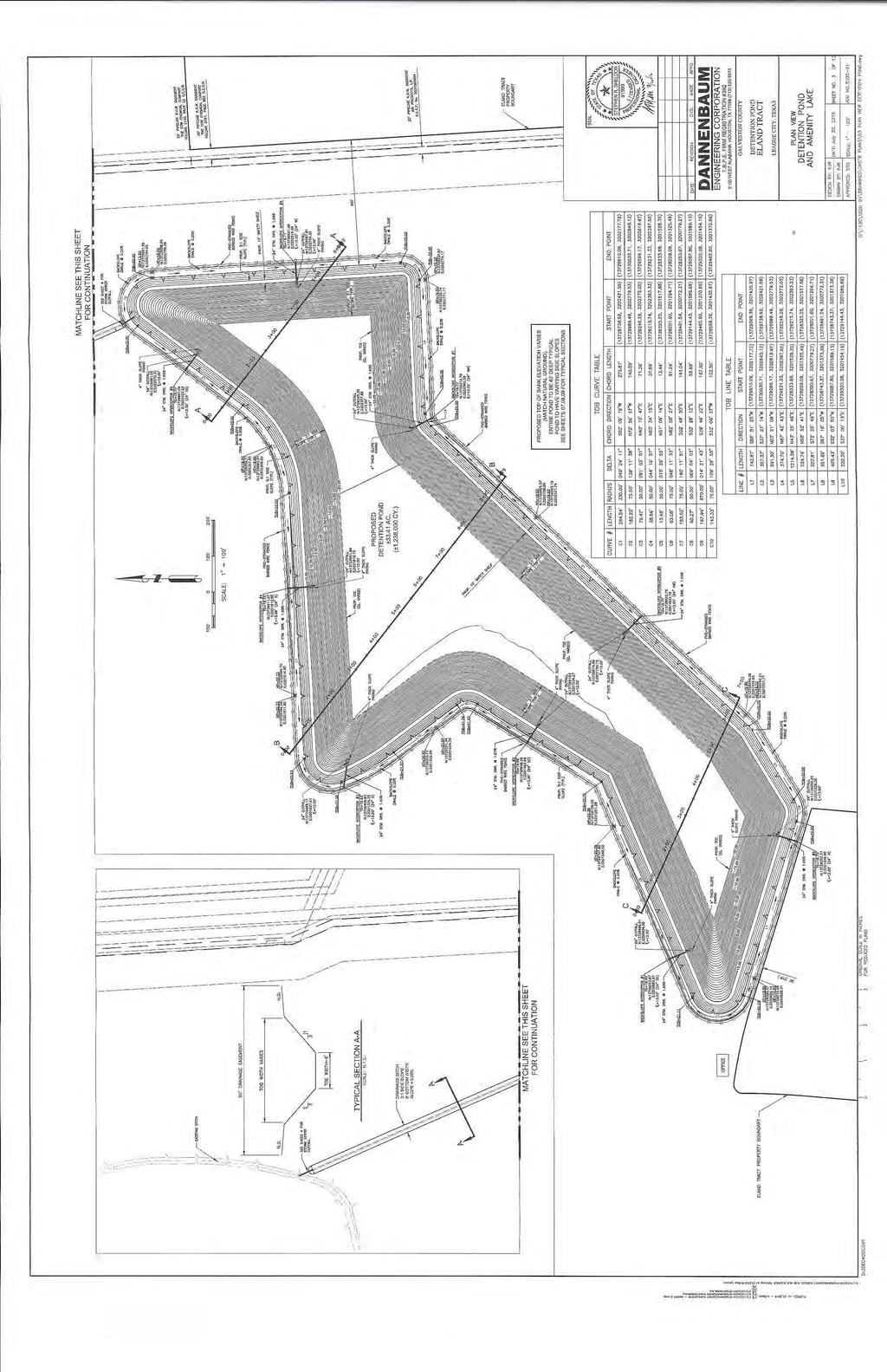
 to allow an excavationn and mining permit to create a sand pit by removingg a total of approximately 1.4 million cubic yards off soil.")
1 Planning & Zoning Commissionn Planning & Development Department August 29, Special Use Permit SUP16-02 (Duncan Sand Pit) Request Applicant Owner Acreage Location City Council Citizen Response Attachments A Special Use Permit (SUP) to allow an excavationn and mining permit to create a sand pit by removingg a total of approximately 1.4 million cubic yards off soil. As a result of a grading and drainage permit, the first 90,000 cubic yards was recently removed from the sand pit area to raise a section of the Sedona Subdivision, also being developed by the applicant. Since this project has recently been completed, the remaining excavated soil will be sold to the public. Once the sand pit has been fully excavated, the remaining 33.5-acre sand pit will serve as a detention/amenity pond for the existing Duncan Plannedd Unit Development (PUD). The applicant indicates the excavation operations are to be completed duringg An excavation and mining permit are subject to thee requirements as set forth in Chapter 98, Article II of o the Code of Ordinances entitled Quarries, Mines and Similar Activities and Chapter 125 of the Code of o Ordinances entitled Zoning. Tracy Goza of LPI Property Management West FM 517, LTD acres Generally located north of FM 517, south of Ervin Street,, and west of Calder Road with the approximate address being in the block of West FM 517. Public Hearing & First Reading September 13 th, 2016; Second Reading September 27 th, Notices Mailed to Property Owners within 500 feet 0 Letters of Support Received 0 Letter of Opposition Received 1. Zoning Map 2. Aerial Map 3. Sand Pit Layout / Drainage Plan 4. Duncan PUD Conceptual Land Use Plan 5. Exhibit of Proposed LPI Residential Subdivision 6. Land Value Assessment Maps A Special Use Permit may allow certain uses of land, buildings, or structures that may not be appropriate under all circumstances in any given zoning district, but may be appropriatee where adequate measures can be taken to assure compatibility with surrounding uses, public need, and the City as a whole. Background August 10, 1999 The subject property was zonedd SDR (Suburban Development Residential) whenn League City adopted zoning. August 31, 2005 The subject property was rezoned from SDR to R-7 (Single-familyy residential with a minimum lot size of 7,000 squaree feet) as partt of the city s Zoning Ordinance & Mapp Revision of July 25, 2006 The subject property was rezoned from R-7 to R-7-PUD (Single-familyy residential with a minimum lot size of 7,000 square feet with a Planned Unit Development Overlay) as SUP16-02 (Duncan Sand Pit) August 29, 2016 P&Z Meeting Page 1 of 4
2 part of the 1,700 acre Duncan Planned Unit Development. The Duncan PUD was created along withh the McAlister and Lloyd PUDs, all located in the southwest side of League City. At this time, noo master plan for the Duncan PUD has been approved by League City. July 30, 2015 The Owner, West FM 517, LTD, purchases the property. August 12, 2015 Applicant makes initial inquiryy about receiving an Excavation Permit. October 5, 2015 City Staff and the Applicant meet to discuss the process to receive an Excavationn Permit. February 25, 2016 The League City Building Department issues a Grading and Drainage Permit for the applicant to begin removing the top 1-foot of dirt to begin raising a nearby residential section of thee Sedona Subdivision, also owned by the applicant. Note: Excavation / Mining uses begin at a depthh greater than one foot below the ground. March 16, 2016 Applicant holds a neighborhood d meeting to discuss the proposed SUP application. March 21, 2016 Applicant submits an application, fee and documentation for an SUP to thee Planning Department. August 5, 2016 Planning Staff sent out public hearing notices to the surrounding property owners and installed public hearing signs on the subject property. August 7, 2016 Public hearing notice was published in the newspaper. August 29, 2015 The Planning and Zoning Commission is scheduled to hold a public hearing andd forward a recommendation to City Council. September 13, 2016 City Council is scheduledd to conduct public hearing and consider request onn first reading. September 27, 2016 Subject to approval on firstt reading, City Council to consider request on secondd reading. Site and Surrounding Area The site is undeveloped with high grass and trees with the densest vegetation located in the northeast corner of the property. There are no protected treess on the site. In the surrounding area, undeveloped tracts lie to the south, west and north and northeast. A residential subdivision, Prairie Estates, lies directly adjacent to the property, located just outside the city limits. Direction North South East West Surrounding Zoning R-7-PUD ROW and R-7 R-7-PUD and OS-PUD and City Limits R-7-PUD Surrounding Land Use Undeveloped (Duncan PUD) FM 517 and Undeveloped Property Bay Colony West PUD and City Limits Undeveloped (Duncann and Lloyd PUDs) Traffic Impacts and Access Sole accesss to the site will be provided by an existing driveway along FM 517. The applicant submitted a Traffic Impact Assessment (TIA) forr the proposed project. The TIA indicates that the project would have a maximum of 15 peak hour trips per day based on the amount of dirt that is proposed to be removed. There were no recommendations for roadway or driveway improvements. The Engineering Department has reviewed the TIA and has no objections. FM 517 Roadway Type Right-of-way Width Pavement Width and Type Current Conditions Major Arterial 100 feet 2-lane, 12-foot widths each way, asphalt with 10-foot shoulders and drainage ditches on either side. Proposed Conditions (MMP) Major Arterial As Determined by TxDOT As Determined by TxDOT SUP16-02 (Duncan Sand Pit) August 29, 2016 P&Z Meeting Page 2 of 4
3 Setbacks Drainage, Lateral Support, and Geology Report Reclamation Land Values Bond Stafff Recommendationn No permit shall be issued for any excavation when any portion of the same shall be located within 200 feet of any public street or road. The proposed excavation is greaterr than 200 feet from the nearest public street or road. Based on the proposed engineered drawings, the Engineering Department has no objection to the request. The applicant shall install and maintain a drainage system to keep the excavation from collecting water, provide documentation from a certified engineer that identifies the characteristics of the soil in order to laterally stabilize the soil subject to the soil conditions, and provide a written geology report from a certified geologist for anyy excavation within 2,500 feet of an existing water well. The applicant has provided engineered construction plans and a Water Well Search and Geological Assessment Report for the site. The construction plans have addressed how storm water will exit the site in a controlled manner as well as how the sides will be laterally stability. In addition, the geologic study identified six (6) water wells within 2,500 feet of the proposed excavation. Then Engineering Department has reviewed these documents and has no objections to the proposed request. The applicant must supply an acceptable reclamation plan which specifies the intended use of the land following excavation whereby the result off the activity is reverted back to a beneficial land use. The applicant proposes to use the sand pit for a future detention/amenity pond. The detention will be for multiple developments within the Duncan PUD. The applicant s submitted exhibit has not been approved and is a conceptual plan. The proposed development is subject to the regulations of the Duncan PUD and any changes to the master plan mustt be approved by the City before the platting and construction phases for the propertyy can begin. Attachment 6 provides two maps that show the land and overall value of land on a per square foot basis. The valuation data came from the 2016 GCAD (Galveston County Appraisal District) assessments. The purpose of these maps are to identify the land values of the surrounding areas and to evaluate if theree are any anticipated negative effects ass a result of the proposed operation. The subject property values are in keeping with the surrounding properties within ¼ mile. The maps identify the difference in values are due too either 1) an improvement on the property such as a residence, or 2) the large size of a contiguous property. It should be noted that theree are several sand pits within the southwest region of League City where previous analysis have shown no change to the values. This suggests that an excavation operation neither increases or decreases land values of those surrounding uses and becomes negligentt with the surrounding area, especially once development surrounding the converted sand pit begins. The applicant is required to give the bond with a good and sufficient corporate surety in favor of the city in an amount no less than $100,000.00,, for which the bond shalll be conditioned that the permitteee shall comply with all the terms of such permit and all laws and ordinances relating to issuance of same. In addition, liability insurancee must be carried by the applicant in the amount to be no lesss than $1,000, Based on the proposed project, staff will recommend that amounts be set at $100,000 bond and $1,000,000 of liability insurance. Staff recommends approval of the Special Use Permit subjectt to the conditions listed below: 1. The Special Use Permit is valid beginningg on the date of adoption of this SUP ordinance andd will expire on December 31, Any extensions of this SUP shall be approved prior to thee expiration date of the permit. 2. The applicant shall submit a bond to the City of League City in the amount of $100, SUP16-02 (Duncan Sand Pit) August 29, 2016 P&Z Meeting Page 3 of 4
4 3. The applicant shall provide proof of insurance for the subject property in the amount of $1,000, and maintain such insurancee as long as excavation operations continue prior to the second reading of the request. 4. The Special Use Permit is limited to excavation and mining uses only with the sand pit being constructed in the location as shown in the attached engineered layout. Within 45 days of completion, the applicant will provide a survey signed and sealed by a Registered Professional Land Surveyor (RPLS) confirming the conformance with the layout. 5. The applicant must receive a Business Registration Permit from the City of League City prior to the selling of any soil to the public. 6. Any signage for the site shall require sign permits and meet the requirements of League City s Sign Ordinance. 7. The proposed on-site office must meet building setbacks and provide parking at the rate of 4 parking spaces per 1,000 square feet of gross floor area. For additional information, you may contactt Mark Linenschmidt, Senior Planner att or at mark.linenschmidt@leaguecity.com. SUP16-02 (Duncan Sand Pit) August 29, 2016 P&Z Meeting Page 4 of 4

5 / MARY FM 517 Planned Unit Development Residential Single Family 20 Residential Single Family 10 Residential Single Family 7 Residential Single Family 5 Neighborhood Commercial General Commercial Public and Semi-Public Open Space Zoning Map City of League City Department of Planning & Development For Planning Purposes Only 1 inch equals 1,258 feet


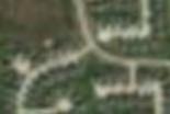


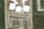
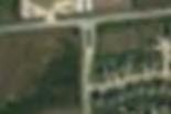


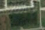

6 Undeveloped Duncan PUD Bay Colony West PUD Subject Property Prairie Estates Subdivision Bay Colony West PUD Chanlee Estates and Tallow Forest Subdivisions Bay Colony West PUD FM 517 City Limits
7
8
 ±13.7 acres ±9.1 acres Santa Fe I.S.D. Dickinson I.S.D. ±25.2 acres ±5.6 acres ±13.4 acres COM ±23.2 acres ±17.7 acres (85 LOTS) ±20.")
9 c Magnolia Creek American Canal ±10.3 acres American Canal ±15.5 acres ±21.0 acres ±20.6 acres ±18.6 acres ELEMENTARY SCHOOL ±16.0 acres ±20.4 acres ±15.6 acres TH ±7.3 acres CLUSTER CLUSTER ±1.4 acres ±10.6 acres COM OR LECT PROPO L O C D SE (85 LOTS) ±13.7 acres ±9.1 acres Santa Fe I.S.D. Dickinson I.S.D. ±25.2 acres ±5.6 acres ±13.4 acres COM ±23.2 acres ±17.7 acres (85 LOTS) ±20.6 acres ±24.9 acres ±18.6 acres eline Easement PATIO ±7.6 acres eline Easement ±4.4 acres ±9.4 acres TH ±4.0 acres ±19.3 acres ±12.4 acres ±20.0 acres ±9.5 acres ED PR OP OS ±1.5 acres REC ±29.9 acres 20' Dow Chemical Co. Pip ±17.5 acres (70 LOTS) ±21.9 acres DS/ s Co. Easement 30' AMOCO (Pan American) Ga ±4.7 acres ±18.2 acres COM ±12.0 acres ±43.9 acres ±3.8 acres ±3.5 acres ±21.7 acres ELEMENTARY SCHOOL ±19.9 acres (70 LOTS) ±15.5 acres PO S Santa Fe I.S.D. Dickinson I.S.D. ED M AJ OR AR TE ±2.3 acres O PR LINEAR ±2.1 acres en em ee as o. P ec lin Pip e ps C re e k ipe lin ±3.5 acres illi ar ±1.0 acres Ph ±3.5 acres acres ±25.2 LINEAR ±1.3 acres ±33.1 acres ±19.1 acres ±1.5 acres ±24.8 acres AM O 20' CO Pa Dow n Am Che eric 20' mic an G al C 20' She o. P as Co Hou ll Pi ipel. Pip sto pelin ine np ec Easeline E ipel orp eme ase ine. Pi Co. pelin nt men Pipe e E t line ase m Eas en eme t nt ±4.1 acres ±11.5 acres REC ±3.8acres ELEMENTARY SCHOOL ±15.2 acres COM ±19.2 acres ±25.4 acres COM ±6.0 acres prepared for W Y N N E / JAC K S O N. I N C. E L A N D D E V E L O P M E N T C O R P., A JOINT VENTURE ±15.5 acres ±18.1 acres D U N CA N T R ACT 200 ±24.8 acres 20' a conceptual landuse plan for 0 (70 LOTS) ±21.0 acres F.M. 517 SCALE ±6.4 acres ±2.7 acres LINEAR ±0.8 acres ±1.0 acres LINEAR ±0.8 acres COM (85 LOTS) ±10.5 acres ±23.6 acres LINEAR ±3.3 acres ±22.5 acres (85 LOTS) ±13.2 acres ±26.6 acres NEIGHBORHOOD COMMERCIAL t ±33.4 acres 6' (70 LOTS) LINEAR ±20.1 acres ±2.1 acres ±15.0 acres ±15.2 acres TOR LINEAR ±2.2 acres ±7.9 acres DAY CARE EMERGENCY SERVICES AL I R LINEAR ±1.1 acres PROPOSED COLLEC ±28.6 acres ±4.8 acres ±1.6 acres ±2.0 acres DS/ ±26.1 acres ±15.2 acres ±6.8 acres ±47.5 acres Ced BUSINESS eline Easement L PROPOSED ANDING ST. ERIAL PROPOSED MAJOR ART ±5.0 acres ±21.7 acres Pipeline Easement American Gas Co. elin 30' AMOCO Panto. Pip e Easement 20' Hous n Pipeline Co BUSINESS DS/ 20' Shell Pipeline Corp. Pipeline Easement Y A W K R A P D N A R G D E S O P PRO HOBBS RD. PATIO ±27.6 acres JUNE, 2006 KGA #02003 THIS DRAWING IS A PICTORIAL REPRESENTATION FOR PRESENTATION PURPOSES ONLY AND IS SUBJECT TO CHANGE. FURTHER, SAID DRAWING IS A SCANNED IMAGE ONLY AND IS NOT FOR COMPUTATION OR CONSTRUCTION PURPOSES. THIS DRAWING MAY OR MAY NOT INCORPORATE INFORMATION AND/OR DATA PROVIDED TO KERRY R. GILBERT & ASSOCIATES, INC. BY OTHER CONSULTANTS RELATIVE TO ENGINEERING AND DRAINAGE, FLOOD PLAINS AND ENVIRONMENTAL ISSUES AND SHOULD NOT BE RELIED UPON FOR ANY PURPOSE. NO WARRANTIES, EXPRESS OR IMPLIED, CONCERNING THE ACTUAL DESIGN, LOCATION, AND CHARACTER OF THE FACILITIES SHOWN ON THIS MAP ARE INTENDED. ADDITIONALLY, NO WARRANTY IS MADE TO THE ACCURACY OF THE INFORMATION CONTAINED HEREIN. Forney & McCombs Pip ±14.9 acres ±2.5 acres (70 LOTS) ±14.0 acres ast Pip al Tra elin n e E smis ase sio me n C orp nt. DS/ 30' Dow Chemical Co. Pip PATIO DAY CARE PO RVI E D SE ±19.6 acres ' Co RE T NS NEIGHBORHOOD COMMERCIAL LA ND Clear Creek I.S.D. Santa Fe I.S.D. ±19.9 acres PR O ±13.6 acres ±2.5 acres ST. BETTIE M. CARNES & SOL CARNES ING CHURCH Clear Creek I.S.D. Dickinson I.S.D. NEIGHBORHOOD COMMERCIAL 20 ±2.1 acres ET PROPOSED COLLECTOR ±16.0 acres EMERGENCY SERVICES ±22.2 acres ±2.1 acres ±11.5 acres Pr a i r i e Estates Bay Colony West Ta l l o w Fo r e s t

10
11 TALLOW FOREST ST MARY LN PEACH MILLLN RIVER RIDGE LN AVERY SPRINGS LN ARBOR HOLLOW LN ROCKY COVE LN BAY CREEK DR BLUE CYPRESS LN BAY AREA BLVD SPRING CANYON DR CROSS CREEK LN CRANE HAWK LN SISKIN TRL LANDING BLVD FLORENCEDR GREY KIRBYDR REDROCKRD KAIBABRD ORACLEDR SEDONADR BUTLER RD ERVIN ST PAMPAS LN HOLLY LN WILLOW LN BROOKPORTDR CALDER DR CRYSTAL ISLE DR CROSS COLONYDR CANYON MIST LN FM 517 Total Valuation per Sq Ft SQFTTotal $ $ 0.65 $ $ 2.07 $ $ 4.55 $ $ 7.12 $ $ The City of League city makes no claims to the accuracy of the map. It is intended for demonstrational purposes only. ¹ 8/23/2016 GIS Department City of League City
12 TALLOW FOREST ST MARY LN PEACH MILLLN RIVER RIDGE LN AVERY SPRINGS LN ARBOR HOLLOW LN ROCKY COVE LN BAY CREEK DR BLUE CYPRESS LN BAY AREA BLVD SPRING CANYON DR CROSS CREEK LN CRANE HAWK LN SISKIN TRL LANDING BLVD FLORENCEDR GREY KIRBYDR REDROCKRD KAIBABRD ORACLEDR SEDONADR BUTLER RD ERVIN ST PAMPAS LN HOLLY LN WILLOW LN BROOKPORTDR CALDER DR CRYSTAL ISLE DR CROSS COLONYDR CANYON MIST LN FM 517 Land Valuation per Sq Ft SQFtLand $ $ 0.41 $ $ 0.72 $ $ 0.84 $ $ 0.91 $ $ 1.99 The City of League city makes no claims to the accuracy of the map. It is intended for demonstrational purposes only. ¹ 8/23/2016 GIS Department City of League City
Planning & Zoning Commission
 Planning & Zoning Commission Planning & Development Department August 14, 01 Zoning Map Amendment MAP-1-0001 (Bay View Section 4) Request Rezone approximately 1.19 acres from OS (Open Space) to RSF- (Residential
Planning. Special Use. to operate a. future. 1.5 acres. Avenue and. west of State. 31 Notices. Citizen. 0 Letter of. compatibility with.
 Planning & Zoning Commissionn Planning & Development Department December 21, 20155 Special Use Permit SUP15-09 (Vanderford Air) Request Hold a public hearing and make a recommendationn to City Council
Planning. This request. incorporatedd develop the. Highway 3. similar to a. Fineas + Clover. Terri Lera of. 35 Notices. Citizen
 Zoning Change Z15-20 (Hwy 3 & Olive) Planning & Zoning Commissionn Planning & Development Department April 4, 20166 Request Rezone approximately 14.32 acres from IL (Limited Industrial) and OS (Open Space)
Planning. the propertyy. Texas Local. Government. Code. size of 2,0000 RSF-2-PUD. Road within the Wharf at a. Citizen. 0 Letter of. 1.
 Planning & Zoning Commissionn Replat Phase I of the Wharf at Clear Lake, Dock 18, Slips 1 and 2 Planning & Development Department February 15, 20166 Request Replat approximately 0.0209 acres of a previouslyy
Preliminary Plat - Westover Park, Section 11C
 Sectti ion 13A Wessttoverr Parrk,, Reccrreatti ion Cttrr Sectti ion 11C Sectti ion 11A Sectti ion 15 Sectti ion 16 Sectti ion 14A Sectti ion 14B Preliminary Plat - Westover Park, Section 11C Planning and
Planned Unit Development Overlay District. For. McAlister Tract PUD
 Planned Unit Development Overlay District For McAlister Tract PUD Prepared For Land Funds Two & Three, J.V. Kerry R. Gilbert & Associates, Inc. June, 2006 TABLE OF CONTENTS I. INTRODUCTION 1 II. SITE INVENTORY
Planning & Zoning Commission
 Final Plat Lakes in Bay Colony, Section 7 Planning & Zoning Commission Planning & Development Department March 20, 2017 Request Applicant Owner Zoning Location Attachments Subdivide approximately 17.16
Planning. 5,000 square , City. west of State. Avenue and. 37 Notices. Citizen. / Zoning Map 2. Aerial Map. Background. Applicant. Council.
 Zoning Change Z15-04 (Alta Vista Development) Planning & Zoning Commissionn Planning & Development Department May 4, 20155 Request Rezone approximately 8.2 acres from RSF-5 (Single-family residential with
Planning & Zoning Commission
 Planning & Zoning Commission Planning & Development Department March 21, 2016 Master Plan Revision Westwood Subdivision, Revision #3 Request Applicant Owner Zoning Location Attachments Background Site
Planning & Zoning Commission
 Zoning Change Z15-08 (2103 ) Planning & Zoning Commission Planning & Development Department May 18, 2015 Request Applicant /Owner Rezone approximately 2.844 acres of land from OS (Open Space) to RSF-20
Planning & Zoning Commission
 Planning & Zoning Commission Planning & Development Department March 3, 2014 Final Plat Bay View Section 2, Phase I Request Applicant Owner Zoning Location Attachments Subdivision of approximately 12.04
Planning. Honda) Special Use. maintenancee. service areaa. City Council Acres. Calder Road. 25 Notices. Citizen. 0 Letter of.
 Special Use. maintenancee. service areaa. City Council Acres. Calder Road. 25 Notices. Citizen. 0 Letter of.") Special Use Permit SUP14-04 (John Eagle Honda) Planning & Zoning Commissionn Planning & Development Department December 15, 20144 Request Hold a public hearing and make a recommendation to City Council
Special Use Permit SUP14-04 (John Eagle Honda) Planning & Zoning Commissionn Planning & Development Department December 15, 20144 Request Hold a public hearing and make a recommendation to City Council
Planning. Zoning Change. prepared for. Staff held an. the neighborhood at the initial meeting. of Texas Avenue. approximate. 29 Notices.
 Planning & Zoning Commissionn Zoning Change Z15-11 (Power Street and Texas Avenue) Planning & Development Department June 15, 20155 Request Rezone approximately 2.0 acres from OS (Open Space) to RSF-20
Planning. Commons. developments. Owner. Zoning. south side of. South Shore Boulevard. 2. Aerial Map. located along. South Shoree.
 Planning & Zoning Commissionn Planning & Development Department February 16, 20144 Development Plan Hidden Lakes Commons Request Applicant Owner Zoning Location Attachments Background Site and Surrounding
Planning & Zoning Commission Meeting Date: December 3, 2012
 Planning and Development Department City of League City Planning & Zoning Commission Meeting Date: December 3, 2012 Requests Rezone approximately 3.3 acres from RSF-5 (Single-family residential with a
Planning & Zoning Commission
 Zoning Change 13-03 (FM 646) Planning & Zoning Commission Planning & Development Department June 3, 2013 Request Permitted Uses Rezone approximately 24.89 acres of undeveloped land from RSF-7 (Residential
For Office Use Only. Permit No. Fee: $ $ per proposed lot (AN ADDITIONAL 10% CODE COMPLIANCE FEE WILL BE CHARGED)
") For Office Use Only Permit No. Fee: $1600 + $560.00 per proposed lot (AN ADDITIONAL 10% CODE COMPLIANCE FEE WILL BE CHARGED) LAND PARTITION FOREST (Conditional Use) Crook County Planning Department 300
For Office Use Only Permit No. Fee: $1600 + $560.00 per proposed lot (AN ADDITIONAL 10% CODE COMPLIANCE FEE WILL BE CHARGED) LAND PARTITION FOREST (Conditional Use) Crook County Planning Department 300
Planning & Zoning Commission
 Planning & Zoning Commission Preliminary Plat Tuscan Lakes, SF 55-2 and 60-2 SE Planning & Development Department March 16, 2015 Request Applicant Owner Zoning Location Attachments Subdivide approximately
Zoning. Road within the Wharf at a. Citizen. 0 Letter of. 2. Aerial Map. Plats. Public Interest the Zoning. because the. January 7,
 Zoning Board of Adjustmentt ZBA15-11 (The Wharf Boat Dock 18, Slips 1 and 2) Planning & Development Department January 7, 20166 Requests A variance from the minimum development requirements for properties
Planning & Zoning Commission
 Planning & Zoning Commission Preliminary Plat Tuscan Lakes, SF 55-3 and 60-3 SE Planning & Development Department May 4, 2015 Request Applicant Owner Zoning Location Attachments Subdivide approximately
Planning. Preliminary. .70 acres into. tract of land. an unplatted. Edgar Barlow. 1. Proposed 2. Aerial Map. Subdivision
 Preliminary / Final Plat Glenmont, Section Two Planning & Zoning Commissionn Planning & Development Department May 19, 20144 Request Applicant Owner Zoning Location Attachments Subdivide approximately.70
Planning & Zoning Commission
 Final Plat Sedona, Section 4 Planning & Zoning Commission Planning & Development Department July 21, 2014 Request Applicant Owner Zoning Location Attachments Subdivide approximately 55.3 acres of previously
Use permitted by: Right Special Exemption
 CENTER TOWNSHIP 150 Henricks Road Butler, PA 16001-8472 Phone (724) 282-7805 Fax (724) 282-6550 Application Number: FEE COLLECTED: Application for: Preliminary Final Land Development Location: Map and
Cover Letter with Narrative Statement
 Cover Letter with Narrative Statement March 31, 2017 rev July 27, 2017 RE: Rushton Pointe Residential Planned Unit Development Application for Public Hearing for RPUD Rezone PL2015 000 0306 Mr. Eric Johnson,
THE CITY OF MOBILE, ALABAMA
 THE CITY OF MOBILE, ALABAMA LE 'I IER OF DECISION Kimberly Clark Mobile Operations 200 Africatown Blvd. Prichard, AL 36610 Re: 100 & 200 Africatown Boulevard (Northeast corner of Bay Bridge Road and Paper
CITY OF OCOEE LAND DEVELOPMENT CODE SUFFICIENCY TABLE WITH NOTES
 CITY OF OCOEE LAND DEVELOPMENT CODE SUFFICIENCY TABLE WITH NOTES The Sufficiency Table is a checklist to help identify the types of information and documentation needed for various types of projects. The
Marion County Board of County Commissioners
 Marion County Board of County Commissioners Date: 12/29/2015 P&Z: 12/28/2015 BCC: 1/12/2016 Item Number 160113Z Type of Application Rezoning Request From: A-1 (General Agriculture) To: PUD (Planned Unit
Planning. 7,000 square. 25 Notices. Citizen. / Zoning Map 2. Aerial Map. Background. - A portion. Late (DRC) for application RMF-1.
 for application RMF-1.") Zoning Change Z15-13 (Cypresss Bay Commercial) Planning & Zoning Commissionn Planning & Development Department July 6, 20155 Request Rezone approximately 2.4 acres from RSF-7 (Single-family residential
Zoning Change Z15-13 (Cypresss Bay Commercial) Planning & Zoning Commissionn Planning & Development Department July 6, 20155 Request Rezone approximately 2.4 acres from RSF-7 (Single-family residential
CONDOMINIUM REGULATIONS
 ARTICLE 37 CONDOMINIUM REGULATIONS SECTION 37.01. Purpose The purpose of this Article is to regulate projects that divide real property under a contractual arrangement known as a condominium. New and conversion
610 LAND DIVISIONS AND PROPERTY LINE ADJUSTMENTS OUTSIDE A UGB
 ARTICLE VI: LAND DIVISIONS AND PROPERTY LINE ADJUSTMENTS VI-21 610 LAND DIVISIONS AND PROPERTY LINE ADJUSTMENTS OUTSIDE A UGB 610-1 Property Line Adjustments (Property Line Relocation) A property line
Article 2 Application Type and Standards Requirements
 Article 1 Article 2 Division 1 Application Type and Standards Requirements General Provisions Sec. 2.1.1 Division 2 Division 3 Division 4 Division 5 Division 6 Division 7 Division 8 Division 9 Sec. 2.9.1
LYON COUNTY COMMUNITY DEVELOPMENT DEPARTMENT
 LYON COUNTY COMMUNITY DEVELOPMENT DEPARTMENT B UILDING D EVELOPMENT E NGINEERING P LANNING 27 S. MAIN S TREET Y ERINGTON, NEVADA 89447 (775) 463-6591 F AX: (775) 463-5305 34 LAKES B OULEVARD D AYTON, NEVADA
COUNTY SUBDIVISION. Attachments: (1) Staff Analysis (2) Subdivision Maps (3) Related Documents including the Disclosure Statement
 Staff Analysis (2) Subdivision Maps (3) Related Documents including the Disclosure Statement") COUNTY SUBDIVISION DOÑA ANA COUNTY PLANNING AND ZONING COMMISSION Doña Ana County Government Center 845 N. Motel Blvd. Las Cruces, New Mexico 88007 Office: (575) 647-7250 MEETING DATE: August 25, 2011
COUNTY SUBDIVISION DOÑA ANA COUNTY PLANNING AND ZONING COMMISSION Doña Ana County Government Center 845 N. Motel Blvd. Las Cruces, New Mexico 88007 Office: (575) 647-7250 MEETING DATE: August 25, 2011
FINAL PLAT CHECKLIST
 FINAL PLAT CHECKLIST Project Name: Tax ID #: Project Number: Date: _ Reviewed By: Telephone: Please address all items marked with an "X" Please return redline comments with corrected plan, original mylar,
M E M O R A N D U M. Planning and Zoning Commission. Daniel Turner, Planner I
 M E M O R A N D U M Meeting Date: Monday, April 10, 2017 Item No. F-4 To: From: Planning and Zoning Commission Daniel Turner, Planner I Subject: Consider a recommendation of a Preliminary Site Evaluation
Appendix J - Planned Unit Development (PUD)
") Appendix J - Planned Unit Development (PUD) Intent and Purpose The purpose of the PUD is: 1. To provide development that is consistent with the Comprehensive Land Use Plan and promote the goals and objectives
Appendix J - Planned Unit Development (PUD) Intent and Purpose The purpose of the PUD is: 1. To provide development that is consistent with the Comprehensive Land Use Plan and promote the goals and objectives
M E M O R A N D U M. Meeting Date: April 9, Item No. F-1. Planning and Zoning Commission. Scott Bradburn, Planner I
 M E M O R A N D U M Meeting Date: April 9, 2018 Item No. F-1 To: From: Subject: Planning and Zoning Commission Scott Bradburn, Planner I PUBLIC HEARING: Consider a recommendation for a Specific Use Permit
Rezoning Report October 2018
 Zone Change Request 3099 W. Parkwood Ave. Request to change from Light Industrial (LI) to Light Industrial / Specific Use Permit (LI/SUP) to allow NAICS Use #7139 Other Amusement and Recreation Industries
4 June 11, 2014 Public Hearing
 4 June 11, 2014 Public Hearing APPLICANT: FRANKLIN JOHNSTON MANAGEMENT DEVELOPMENT, L.L.C. PROPERTY OWNER: TRUSTEES OF FIRST LYNNHAVEN BAPTIST CHURCH STAFF PLANNER: Stephen J. White REQUEST: Change of
Section Preliminary Plat Checklist and Application Forms
 Section 201 - Preliminary Plat Checklist and Application Forms PRELIMINARY SUBDIVISION PLAT REVIEW PROCESS CHART PRELIMINARY SUBDIVISION PLAT APPLICATION PRELIMINARY PLAT REVIEW CHECKLIST CITY OF NAMPA
A.3. ARTICLE 7 PLAN REQUIREMENTS FOR MINOR SUBDIVISION AND/OR LAND DEVELOPMENT
 700. 701.A.3. ARTICLE 7 PLAN REQUIREMENTS FOR MINOR SUBDIVISION AND/OR LAND DEVELOPMENT SECTION 700 PURPOSE The purpose of this Article is to set forth a streamlined set of Plan Requirements for minor
Planning Department Oconee County, Georgia STAFF REPORT
 Planning Department Oconee County, Georgia STAFF REPORT REZONE CASE #: 7332 DATE: November 28, 2017 STAFF REPORT BY: Gabriel Quintas, Planner APPLICANT NAME: Smith Planning Group PROPERTY OWNER: John Hadden
A. The Preliminary Development Plan consists of five Sheets, as follows:
 Rezoning from A (Agriculture) to RPD (Residential Planned Development) and Approval of a Preliminary Development Plan and Preliminary Subdivision Plat. Wild Plum Farm. Applicant: JPB Holdings LLC, Property
Umatilla County Department of Land Use Planning
 Umatilla County Department of Land Use Planning 216 SE 4 th ST, Pendleton, OR 97801, (541) 278-6252 PROCESSING TYPE I & III APPLICATIONS Land Division, Type I - IV Supplemental Application & Information
CITY OF SARALAND PRELIMINARY SUBDIVISION PLAT REVIEW
 PRELIMINARY SUBDIVISION PLAT REVIEW Application Number: Date Plat Submitted: Name of Subdivision: Name of Owner: Owner Address: (Street or P.O. Box) Telephone #: (City) (State) (Zip) E-mail: Name of Authorized
Condominium Unit Requirements.
 ARTICLE 19 CONDOMINIUM REGULATIONS Section 19.01 Purpose. The purpose of this Article is to regulate projects that divide real property under a contractual arrangement known as a condominium. New and conversion
COMMUNITY DEVELOPMENT. Staff Report. Site Plan Review. SP June 19, 2018
 COMMUNITY DEVELOPMENT 333 Broadalbin Street SW, PO Box 490, Albany, Oregon 97321-0144 BUILDING 541-917-7553 PLANNING 541-917-7550 Staff Report Site Plan Review SP-18-18 June 19, 2018 Summary On May 1,
Conditional Use Permit case no. CU 14-06: Bristol Village Partners, LLC
 PLANNING AND ZONING COMMISSION STAFF REPORT August 7, 2014 Conditional Use Permit case no. CU 14-06: Bristol Village Partners, LLC CASE DESCRIPTION: LOCATION: LEGAL DESCRIPTION: EXISTING LAND USE: ZONING:
Minor Revision to Amend an Existing PD (Rezoning) RLF Kingsland Properties, LLC R-4 Tract Golden Isles Gateway Planned Development
 RLF Kingsland Properties, LLC R-4 Tract Golden Isles Gateway Planned Development") COMMUNITY DEVELOPMENT DEPARTMENT Planning and Zoning Division 1725 Reynolds Street, Suite 200, Brunswick, GA 31520 Phone: 912-554-7428/Fax: 1-888-252-3726 MAINLAND PLANNING COMMISSION STAFF REPORT MEETING
COMMUNITY DEVELOPMENT DEPARTMENT Planning and Zoning Division 1725 Reynolds Street, Suite 200, Brunswick, GA 31520 Phone: 912-554-7428/Fax: 1-888-252-3726 MAINLAND PLANNING COMMISSION STAFF REPORT MEETING
ARTICLE FIVE FINAL DRAFT
 ARTICLE FIVE 021218 FINAL DRAFT Sec. 503.6 Open Space Preservation Option Open Space Preservation Option Open Space Preservation developments may be approved in the AR, R-1, R-2 and R-3 zoning districts,
SUBDIVISION PLAT CHECKLIST. The following information shall be include on the plat:
 SUBDIVISION PLAT CHECKLIST Subdivision Name: Land Surveyor: Owner/Developer: Date Submitted: The following information shall be include on the plat: The plat shall be drawn at a scale of one inch equals
RULES, REGULATIONS AND REQUIREMENTS RELATING TO THE APPROVAL AND ACCEPTANCE OF IMPROVEMENTS IN SUBDIVISIONS OR RE-SUBDIVISIONS
 GALVESTON COUNTY RULES, REGULATIONS AND REQUIREMENTS RELATING TO THE APPROVAL AND ACCEPTANCE OF IMPROVEMENTS IN SUBDIVISIONS OR RE-SUBDIVISIONS GALVESTON COUNTY ENGINEERING DEPARTMENT MARCH 3, 1997 Amendment
Plans shall be drawn at a readable scale, signed, and sealed by a Florida Registered Engineer. The application package shall include:
 CHAPTER 400. SECTION 403. PERMIT TYPES AND APPLICATIONS SITE DEVELOPMENT 403.3. Preliminary Site Plans (PSP) A. Intent and Purpose PSPs are used to identify existing site conditions and demonstrate general
COMMUNITY DEVELOPMENT DEPARTMENT 333 Broadalbin Street SW, P.O. Box 490 Albany, OR 97321
 COMMUNITY DEVELOPMENT DEPARTMENT 333 Broadalbin Street SW, P.O. Box 490 Albany, OR 97321 STAFF REPORT Application for Site Plan Review (SP-02-18) Residential Accessory Building Ph: 541-917-7550 Fax: 541-917-7598
EXHIBIT D. Planned Unit Development Written Description April 13, 2016 Rouen Cove Phase II PUD
 1 EXHIBIT D Planned Unit Development Written Description April 13, 2016 Rouen Cove Phase II PUD Development # 8986.001 Developer: Curtis L. Hart Hart Resources LLC 8051 Tara Lane Jacksonville, Florida
PALM BEACH COUNTY PLANNING, ZONING AND BUILDING DEPARTMENT ZONING DIVISION
 PALM BEACH COUNTY PLANNING, ZONING AND BUILDING DEPARTMENT ZONING DIVISION Application No.: Z-2014-01627 Application Name: Dazco Center Control No.: 2003-00040 Applicant: 4730 Hypoluxo LLC Owners: 4730
PLANNED UNIT DEVELOPMENTS
 PLANNED UNIT DEVELOPMENTS SECTION 9.01 DESCRIPTION AND PURPOSE. A. The purpose of a planned unit development (PUD) is to permit greater flexibility in development than is generally possible under standard
CONDITIONAL USE PERMIT APPLICATION FOR AN EXCAVATION/BORROW PIT
 CONDITIONAL USE PERMIT APPLICATION FOR AN EXCAVATION/BORROW PIT CHESAPEAKE PLANNING DEPARTMENT APPLICATION NUMBER: (Ased by Chesapeake Planning Department) GENERAL INFORMATION Project 1. Applicant(s) Intending
SPECIAL ZONING DISTRICTS
 SPECIAL ZONING DISTRICTS 5.01 5.99 RESERVED 5.100 PLANNED DEVELOPMENTS: Purpose: This district is intended to accommodate unified design of residential, commercial, office, professional services, retail
PLANNED UNIT DEVELOPMENT APPLICATION
 ` PLANNED UNIT DEVELOPMENT APPLICATION CHESAPEAKE PLANNING DEPARTMENT PUD Creation PUD Modification APPLICATION NUMBER: (Assigned by Chesapeake Planning Department) GENERAL INFORMATION Project 1. Applicant(s):
Town of Cary, North Carolina Rezoning Staff Report 14-REZ-24 Indian Wells Road Properties Town Council Meeting November 20, 2014
 Town of Cary, North Carolina Rezoning Staff Report 14-REZ-24 Indian Wells Road Properties Town Council Meeting November 20, 2014 REQUEST To amend the Town of Cary Official Zoning Map by revising a condition
PROPOSED AMENDMENTS TO THE DERBY ZONING REGULATIONS AUGUST 12, 2008
 ARTICLE II Definitions and word usage 195-7. Definitions and word usage. Modify the following: HOUSING FOR THE ELDERLY OLDER PERSONS Housing in accordance with and as defined in the United States Fair
APPLICATION FOR SUBDIVISION APPROVAL OF A SKETCH PLAN with checklist
 Prior to filing any application for SUBDIVISION approval, the applicant shall request in writing that the zoning administrator schedule a pre-submission conference. APPLICATION TO THE PLANNING BOARD TOWN
Marion County Board of County Commissioners
 Marion County Board of County Commissioners Date: 12/2/2015 P&Z: 11/30/2015 BCC: 12/16/2015 Item Number 151210SU Type of Application Special Use Permit Request To establish a Clay Electric Co-Operative
Department of Planning & Development Services
 Department of Planning & Development Services S T A F F R E P O R T February 9, 2015 CASE NO: PROJECT: EXECUTIVE SUMMARY: ZA14-154 Plat Revision for Lots 25R-1A, 25R-1B and 25R-1C, Block 1, Woodland Heights
Initial Subdivision Applications Shall Include the Following:
 Initial Subdivision Applications Shall Include the Following: 1) Subdivision Application Form: completely filled out (12 copies) 2) Plat: The Plat must adhere to the requirements set forth in the Town
LINCOLN COUNTY PLANNING & INSPECTIONS DEPARTMENT
 LINCOLN COUNTY PLANNING & INSPECTIONS DEPARTMENT 30 NORTH ACADEMY STREET, SUITE A, LINCOLNTON, NORTH CAROLINA 809 704-736-8440 OFFICE 704-736-8434 INSPECTION REQUEST LINE 704-73-900 FAX To: Board of Commissioners
Approval of a conditional use to allow construction of a rehabilitation hospital at 5115 N. Biltmore Lane in the American Center.
 Department of Planning & Community & Economic Development Planning Division Katherine Cornwell, Director Madison Municipal Building, Suite LL-100 215 Martin Luther King, Jr. Boulevard P.O. Box 2985 Madison,
ARTICLE 13 CONDOMINIUM REGULATIONS
 ARTICLE 13 CONDOMINIUM REGULATIONS Section 13.01 Purpose. The purpose of this Article is to regulate projects that divide real property under a contractual arrangement known as a condominium. New and conversion
NOT TO BE SUBMITTED WITH SKETCH DESIGN APPROVAL Subdivision Checklist: Major Subdivision Final Plat
 Must be received with review fee (equal to $200.00, plus $25.00 per lot) no later than 15 days prior to Planning Board meeting, which is normally the first Monday of the month (certain holidays may modify
Group Sewer Only** 80 Ft Frontage* 20,000 Sq. Ft. (.46 acre) Minimum** 120 Ft Frontage* 20,000 Sq. Ft. (.46acre) Minimum** 150 Ft Frontage*
 Minimum** 120 Ft Frontage* 20,000 Sq. Ft. (.46acre) Minimum** 150 Ft Frontage*") Residential Lots Minimum Chart The minimum lot size of any minor subdivision where there is no public sewers shall be as shown below or as required by township zoning and/or the Tuscarawas General Health
Residential Lots Minimum Chart The minimum lot size of any minor subdivision where there is no public sewers shall be as shown below or as required by township zoning and/or the Tuscarawas General Health
1 st Hearing: 2 nd Hearing: Publication Dates: Notices Mailed: Rezone, Special Exception and Variance APPLICANT INFORMATION PROPERTY INFORMATION
 City of Okeechobee General Services Department 55 S.E. 3 rd Avenue, Room 101 Okeechobee, Florida 34974-2903 Phone: (863) 763-3372, ext. 218 Fax: (863) 763-1686 1 Name of property owner(s): 2 Owner mailing
LOCAL LAW NO. 2, 1987 A LOCAL LAW REGULATING EXCAVATION AND TOPSOIL REMOVAL WITHIN THE TOWN OF CAMBRIA
 LOCAL LAW NO. 2, 1987 A LOCAL LAW REGULATING EXCAVATION AND TOPSOIL REMOVAL WITHIN THE TOWN OF CAMBRIA PASSED BY TOWN OF CAMBRIA TOWN BOARD SEPTEMBER 3, 1987 Be it enacted by the Town Board of the Town
PRELMINARY PLAT CHECKLIST
 PRELMINARY PLAT CHECKLIST A. All preliminary plat submitted for approval shall be prepared by a Registered Professional Land Surveyor. B. Preliminary plats must be drawn to a scale of XXX with such accuracy
Planned Residential Development ( PRD ) Application
 Application") FOR PLANNING USE ONLY Application # PRD Application Fee $ Receipt No. Filing Date Completeness Date Planned Residential Development ( PRD ) Application A. PROJECT INFORMATION 1. Project Name: 2. Address
FOR PLANNING USE ONLY Application # PRD Application Fee $ Receipt No. Filing Date Completeness Date Planned Residential Development ( PRD ) Application A. PROJECT INFORMATION 1. Project Name: 2. Address
Applications will be received on business days between 9:00 AM and 3:00 PM
 Special Use Permit Application Douglas County Board of Commissioners Douglas County, Georgia Applications will be received on business days between 9:00 AM and 3:00 PM Date of Application: Application
CONCEPT PLAN APPLICATION Meeting with Staff Commercial Projects
 COMMUNITY DEVELOPMENT City of South Salt Lake Community Development Department 220 E. Morris Avenue South Salt Lake City, Utah 84115 Phone (801) 483-6011 Fax (801) 483-6060 CONCEPT PLAN APPLICATION Meeting
LARAMIE COUNTY PLANNING & DEVELOPMENT DEPARTMENT
 LARAMIE COUNTY PLANNING & DEVELOPMENT DEPARTMENT Planning Building MEMORANDUM TO: FROM: Laramie County Board of Commissioners Bryan Nicholas, Associate Planner DATE: May 15, 2018 TITLE: Review and action
MAPLETON CITY CORPORATION. Step 7: Upon final approval and prior to plat recording the applicant shall provide the following:
 MAPLETON CITY CORPORATION Subdivision Process The City s subdivision requirements are designed to facilitate orderly, safe and efficient development and to implement the adopted General Plan. Below is
General Location: Southeast corner of Liberty Drive and East Broadway Street, Pearland, TX.
 JOINT PUBLIC HEARING THE CITY COUNCIL CITY AND THE PLANNING AND ZONING COMMISSION OF THE CITY OF PEARLAND, TEXAS, MONDAY, MARCH 20, 2017 6:30 PM COUNCIL CHAMBERS-PEARLAND CITY HALL-3519 LIBERTY DRIVE I.
Marion County Board of County Commissioners
 Marion County Board of County Commissioners Date: 10/27/2015 P&Z: 10/26/2015 BCC: 11/17/2015 Item Number 151104SU Type of Application Special Use Permit Request Parking of a Commercial Truck in the A-1
CITY OF SARALAND FINAL SUBDIVISION PLAT REVIEW
 CITY OF SARALAND FINAL SUBDIVISION PLAT REVIEW Application Number: Date Plat Submitted: Name of Subdivision: Name of Owner: Owner Address: (Street or P.O. Box) Telephone #: (City) (State) (Zip) E-mail:
MAJOR SUBDIVISION PRELIMINARY PLAT CHECKLIST
 TOWNSHIP OF EGG HARBOR PLANNING BOARD/ZONING BOARD OF ADJUSTMENT 3515 BARGAINTOWN ROAD EGG HARBOR TOWNSHIP, NJ 08234 MAJOR SUBDIVISION PRELIMINARY PLAT CHECKLIST The following checklist is designed to
Cherokee Webster Development, LP. City of Webster, Texas Planned Development No. 3. Proposed Revision No. 4
 Cherokee Webster Development, LP. City of Webster, Texas Planned Development No. 3 Proposed Revision No. 4 October 2013 1 Statement of Intent This Revision No. 4 of the Statement of Intent is written in
ORANGE BLOSSOM GARDENS PLANNED UNIT DEVELOPMENT PREPARED BY: COASTAL ENGINEERING CONSULTANTS, INC.
 ORANGE BLOSSOM GARDENS A PLANNED UNIT DEVELOPMENT PREPARED BY: COASTAL ENGINEERING CONSULTANTS, INC. REVISED OCTOBER 19, 1992 BY THE COLLIER COUNTY LONG RANGE PLANNING DEPARTMENT REVISED DECEMBER, 2008
Gates County Planning and Zoning
 Gates County Planning and Zoning PO Box 411, 200 Court Street, Gatesville, NC 27938 phone: 252-357-2411 fax: 252-357-0073 Application for Technical Review Committee For Staff Use Only: Date: Application
A Final Plat will be reviewed concurrently with any other development review application(s) that is required.
 that is required.") RELATED FACTS TO KNOW: Adams County Recording Requirements, Annexation, Common Wall Subdivision, Development Plan (PUD Development Permit), Fees, Helpful Contact Information, Lot Line Adjustment, Neighborhood
RELATED FACTS TO KNOW: Adams County Recording Requirements, Annexation, Common Wall Subdivision, Development Plan (PUD Development Permit), Fees, Helpful Contact Information, Lot Line Adjustment, Neighborhood
ARTICLE 12 PLANNED UNIT DEVELOPMENT DISTRICTS (PUDS) Sec Intent CHARTER TOWNSHIP OF BRIGHTON ZONING ORDINANCE
 Sec Intent CHARTER TOWNSHIP OF BRIGHTON ZONING ORDINANCE") ARTICLE 12 PLANNED UNIT DEVELOPMENT DISTRICTS (PUDS) Sec. 12-01 Intent 1 2 (a) The intent of this Article is to permit the coordinated development on larger sites, protect significant natural features
ARTICLE 12 PLANNED UNIT DEVELOPMENT DISTRICTS (PUDS) Sec. 12-01 Intent 1 2 (a) The intent of this Article is to permit the coordinated development on larger sites, protect significant natural features
M E M O R A N D U M. Meeting Date: October 23, Item No. F-1. Planning and Zoning Commission. Daniel Turner, Planner I
 M E M O R A N D U M Meeting Date: October 23, 2017 Item No. F-1 To: From: Subject: Planning and Zoning Commission Daniel Turner, Planner I PUBLIC HEARING: Consider a recommendation of a of Planned Development
FINAL DRAFT 12/1/16, Rev. to 7/18/17
 FINAL DRAFT 12/1/16, Rev. to 7/18/17 (As Adopted 8/8/17 Effective 9/1/17) SHELTON PLANNING AND ZONING COMMISSION Proposed Amendments to Zoning Regulations I. Amend Section 23 PERMITTED USES by inserting
PLANNING AND ZONING COMMISSION VARIANCE
 PLANNING AND ZONING COMMISSION VARIANCE DOÑA ANA COUNTY COMMUNITY DEVELOPMENT DEPARTMENT Doña Ana County Government Center 845 N. Motel Blvd. Las Cruces, New Mexico 88007 Telephone: (575) 647-7350 MEETING
Preliminary Re-Plat Application & Submittal Checklist
 City of Live Oak Planning & Zoning Department 8001 Shin Oak Drive Live Oak, Texas 78233 (210) 653-9140, ext. 2219 www.liveoaktx.net CC/Cash/Check No.: Amount: $ Receipt No.: Submittal date office use only
Chapter 22 PLANNED UNIT DEVELOPMENT.
 Chapter 22 PLANNED UNIT DEVELOPMENT. Sec. 22.1 INTENT. The use of land and the construction and use of buildings and other structures as Planned Unit Developments in Georgetown Township may be established
SITE DEVELOPMENT PLAN REQUIREMENTS CHECKLIST
 SITE DEVELOPMENT PLAN REQUIREMENTS CHECKLIST Completed DRC Application for Review Required for Application Process DRC Processing Fee 1 Commercial $2,500.00 Fire Department Review Fee 150.00 Total $2,650.00
A. Appropriate agency responsible for transportation review for the subject property.
 7.8.10 Procedure Any person desiring to create a minor subdivision shall submit to the Commission for approval an application on forms provided by the Division, and a record plat in conformance with the
CITY OF FERNDALE HEARING EXAMINER
 CITY OF FERNDALE HEARING EXAMINER RE: Planned Unit Development ) 16001-PUD Preliminary Plat ) 16018-SE Plat Variance ) 16002-VAR Application by ) ) MD General, L.L.C. ) FINDINGS OF FACT, Malloy Heights
Short Title: Performance Guarantees/Subdivision Streets. (Public) April 28, 2016
 April 28, 2016") GENERAL ASSEMBLY OF NORTH CAROLINA SESSION S SENATE BILL Transportation Committee Substitute Adopted // House Committee Substitute Favorable // Fourth Edition Engrossed // Short Title: Performance Guarantees/Subdivision
GENERAL ASSEMBLY OF NORTH CAROLINA SESSION S SENATE BILL Transportation Committee Substitute Adopted // House Committee Substitute Favorable // Fourth Edition Engrossed // Short Title: Performance Guarantees/Subdivision
Planning Commission Application Summary
 Planning Commission Application Summary Project Name: Lone Peak Business Park Minor Subdivision request Address: 12044 South Lone Peak Pkwy. Current Zoning: CSD-LP (Lone Peak Commercial Special District)
City of Colleyville Community Development Department. Subdivision Application Packet
 Community Development Department Subdivision Application Packet 1 Development Application Fees 100 Main Street Colleyville TX 76034 817.503.1050 Zoning Zoning Change $ 500 + $5 per acre Planned Unit Development
PALM BEACH COUNTY PLANNING, ZONING AND BUILDING DEPARTMENT ZONING DIVISION
 PALM BEACH COUNTY PLANNING, ZONING AND BUILDING DEPARTMENT ZONING DIVISION Application No.: PDD/W/R/TDR-2015-01036 Application Name: Lake Worth Senior Living Control No.: 2005-00122 Applicant: Amelia Trevino