RISK ASSESSMENT APPENDIX E HAZARD ANALYSIS RESULTS
|
|
|
- Jordan Horton
- 5 years ago
- Views:
Transcription


1 RISK ASSESSMENT E0 APPENDIX E HAZARD ANALYSIS RESULTS
2 E1 NORTHUMBERLAND COUNTY HMP
3 RISK ASSESSMENT E2 APPENDIX E HAZARD ANALYSIS RESULTS Summary Nearly ninety percent of federal disaster declarations are for flood events. For this reason, our potential loss estimate and hazard analysis focuses on flooding impacts within the 100 year flood plain as recognized by the most current FEMA DFIRM data. The predictability of flooding allows us to accurately portray the impact from a monetary standpoint more so than for rockslides, landslides, straight line winds/tornadic activity, blizzard conditions and dam failure all of which have the ability to cripple communities throughout the county. Inevitably, flooding along both branches of the Susquehanna River and many of the larger tributaries draining into the Susquehanna watershed makes this our largest concern. The Department of Geographic Information Systems of the County of Northumberland conducted an analysis of the structures impacted by the 1% annual chance flood hazard (100-year flood hazard). Utilizing the 1% annual chance special flood hazard areas (FEMA), tax parcels (Northumberland County GIS), and building centroids (Northumberland County GIS) the Department identified those at risk structures impacted by a flood hazard. Using those at risk structures, were able to determine the associated structures valuation data maintained by the county Assessment Office. Northumberland County s assessed values are used for ad valorem taxation purposes only. They are a market value derived from our base year cost tables; Northumberland County currently has a base year of Current assessed values cannot be communicated as true market value because of the difference between base year and current or actual year. The State provides each assessment office with a common level ratio to apply to assessed values in order to equate them to a more realistic, market based value. If assessments are used to represent loss without applying the common level ratio, totals would be considerably skewed away from values that would represent true loss. The common level ratio for for Northumberland County is 25.6%; the ratio is used to explain that after all valid sales in our county are reviewed and compared against the assessment for the corresponding parcel, the average assessment represents 25.6% of what a property could possibly sell for on an open market. Using the following formula, (building assessed value divided by.256), the structures valuation was converted from 1972 market value to market value. To simulate the estimated loss for a 1% annual flood event, 25% was applied to each structures 2017 market valuation. The map below shows all parcels that intersect the SFHA and their corresponding values. The estimated loss for a 1% annual chance flood hazard was summarized by municipality and classified by structure land use (Northumberland County GIS, 2017).


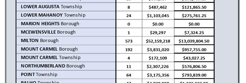
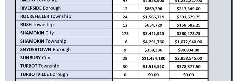

4 E3 NORTHUMBERLAND COUNTY HMP
5 RISK ASSESSMENT E4 Northumberland County Parcels with Building Assessed Values in SFHA by generalized Land Use type Code Description COUNT A AGRICULTURE 75 C COMMERCIAL 236 E EXEMPT 74 G GARAGE 8 I INDUSTRIAL 24 P PUBLIC UTILITY 7 Q BUILDING 10 R RESIDENTIAL 1408 M MOBILE HOME 191 V VACANT 47 Y CABIN 1 Northumberland County Parcels with Building Assessed Values in SFHA by detailed Land Use type Code Description COUNT 0 EXEMPT RES. - 3 OR LESS LIVING UNITS TRL, MH, MOD/NO BSMT, DOUBLEWIDES SEASONAL HOUSING LOTS (LESS THAN 10 ACRES) INDUSTRIAL VACANT INDUSTRIAL WITH BUILDING COMMERCIAL VACANT COMMERCIAL W/BLDG ASSD OVR $20, COMMERCIAL W/BUILDING AGRICULTURAL (10+ ACRES & BUILDING) AGRICULTURAL VACANT (10+ AC) MISCELLANEOUS LAND (MORE THAN 10 AC) 4

6 E5 NORTHUMBERLAND COUNTY HMP
2018 Budget Presentation Assessor s Office. Steve Schleiker, El Paso County Assessor Presentation Date: November 9, 2017
 2018 Budget Presentation Assessor s Office Steve Schleiker, El Paso County Assessor Presentation Date: November 9, 2017 Organizational Chart Assessor s Office 2 Operations County Assessor Is responsible
Mingo County, WV Community Coordination Preliminary Flood Insurance Study and Flood Insurance Rate Map. Thursday, September 25, 2014
 Mingo County, WV Community Coordination Preliminary Flood Insurance Study and Flood Insurance Rate Map Thursday, September 25, 2014 Overview Preliminary Materials Preliminary FIS Report Digital Flood Insurance
MEMORANDUM. Apportionment Methodologies
 MEMORANDUM To: From: CC: Date: Re: Board of Hudson River - Black River Regulating District Glenn A. LaFave, Executive Director Robert P. Leslie, General Counsel Richard J. Ferrara, Chief Fiscal Officer
Appendix A Reproducible Forms
 Appendix A Reproducible Forms Form LD-33 LD-34 LD-35 LD-40 LD-41 LD-42 LD-50 LD-51 LD-52 LD-53 Subject County Engineer Approval Form Storm Sewer Computation Sheet Ohio Drainage Design Criteria Form Gutter
ASSESSMENT METHODOLOGY
 2018 ASSESSMENT METHODOLOGY MULTI-RESIDENTIAL MANUFACTURED HOME PARK A summary of the methods used by the City of Edmonton in determining the value of multi-residential manufactured home park land properties
MAP INDEX CHECKLIST NOTES:
 REVIEWING YOUR PRELIMINARY DFIRM PANELS AND FIS REPORT A GUIDE FOR COMMUNITY OFFICIALS When a Georgia community is presented with new Digital Flood Insurance Rate Map (DFIRM) panels, the State of Georgia,
Type II Replacement Dwelling (EFC) Packet updated 07/07/16
 Packet updated 07/07/16") WASHINGTON COUNTY Dept. of Land Use & Transportation Planning and Development Services Current Planning 155 N. 1 st Avenue, #350-13 Hillsboro, OR 97124 Ph. (503) 846-8761 Fax (503) 846-2908 http://www.co.washington.or.us
WASHINGTON COUNTY Dept. of Land Use & Transportation Planning and Development Services Current Planning 155 N. 1 st Avenue, #350-13 Hillsboro, OR 97124 Ph. (503) 846-8761 Fax (503) 846-2908 http://www.co.washington.or.us
Chapter 12 Changes Since This is just a brief and cursory comparison. More analysis will be done at a later date.
 Chapter 12 Changes Since 1986 This approach to Fiscal Analysis was first done in 1986 for the City of Anoka. It was the first of its kind and was recognized by the National Science Foundation (NSF). Geographic
Mulberry Prime Development
 Mulberry Prime Development Lakefront site for Sale TE R STA 3825 South Florida Ave. Suite 5 Lakeland, FL 33813 OAD Phone: 863-619-6740 Fax: 863-619-6750 37 / N. C maria@mahoneygroupinc.com www.mahoneygroupinc.com
CHAPTER 4. MANAGER Single-Family Multi-Family Total. CHAPTER 4: AREA OF IMPACT AND BUILDOUT ANALYSIS Housing Needs Analysis
 The Area of Impact, the areas that Blueprint Boise identifies as potential annexation areas, have come up in several conversations with city officials in the context of the housing analysis. The Area of
To: Property Appraisers, Taxing Authorities and Interested Parties From: James McAdams Date: June 5, 2012 Bulletin: PTO 12-04
 Property Tax Oversight Bulletin: PTO 12-04 To: Property Appraisers, Taxing Authorities and Interested Parties From: James McAdams Date: Bulletin: PTO 12-04 FLORIDA DEPARTMENT OF REVENUE PROPERTY TAX INFORMATIONAL
IMPORTANT ANNOUNCEMENT: Our website is changing! Please click here for details.
 IMPORTANT ANNOUNCEMENT: Our website is changing! Please click here for details. Home Search Downloads Exemptions Agriculture Maps Tangible Links Contact Home Frequently Asked Questions (FAQ) Frequently
METHODOLOGY GUIDE VALUING LANDS IN TRANSITION IN ONTARIO. Valuation Date: January 1, 2016
 METHODOLOGY GUIDE VALUING LANDS IN TRANSITION IN ONTARIO Valuation Date: January 1, 2016 August 2017 August 22, 2017 The Municipal Property Assessment Corporation (MPAC) is responsible for accurately assessing
METHODOLOGY GUIDE VALUING MOTELS IN ONTARIO. Valuation Date: January 1, 2016
 METHODOLOGY GUIDE VALUING MOTELS IN ONTARIO Valuation Date: January 1, 2016 AUGUST 2016 August 22, 2016 The Municipal Property Assessment Corporation (MPAC) is responsible for accurately assessing and
COUNTY OF LINCOLN, NORTH CAROLINA
 COUNTY OF LINCOLN, NORTH CAROLINA 302 NORTH ACADEMY STREET, SUITE A, LINCOLNTON, NORTH CAROLINA 28092 PLANNING AND INSPECTIONS DEPARTMENT 704-736-8440 OFFICE 704-732-9010 FAX To: George Wood County Manager
TOWN OF PELHAM, NEW HAMPSHIRE
 TOWN OF PELHAM, NEW HAMPSHIRE BUILDOUT ANALYSIS Prepared for the PELHAM CONSERVATION COMMISSION with the assistance of the NASHUA REGIONAL PLANNING COMMISSION TABLE OF CONTENTS I. INTRODUCTION...1 II.
ANNEX B: TOWN OF BLUE RIVER
 B.1 Community Profile ANNEX B: TOWN OF BLUE RIVER Figure B.1 shows a map of the and its location within Summit County. The map also shows critical facilities and landslide deposits. Figure B.1. Map of
Before the Minnesota Public Utilities Commission State of Minnesota. Docket No. E002/GR Exhibit (LMC-1) Property Taxes
 Property Taxes") Direct Testimony and Schedules Leanna M. Chapman Before the Minnesota Public Utilities Commission State of Minnesota In the Matter of the Application of Northern States Power Company for Authority to Increase
Direct Testimony and Schedules Leanna M. Chapman Before the Minnesota Public Utilities Commission State of Minnesota In the Matter of the Application of Northern States Power Company for Authority to Increase
Sec Definitions. [Note: the long list of definitions related to Mobility will appear in the Handbook.]
![Sec Definitions. [Note: the long list of definitions related to Mobility will appear in the Handbook.]](/thumbs/81/82623295.jpg "Sec Definitions. [Note: the long list of definitions related to Mobility will appear in the Handbook.]") PART 5. - MOBILITY FEE SYSTEM Footnotes: --- (3) --- Editor's note Ord. 2011-536-E, 1, amended the Code by repealing former Pt. 5, 655.501, in its entirety, and adding a new Pt. 5, 655.501 655-512. Former
PART 5. - MOBILITY FEE SYSTEM Footnotes: --- (3) --- Editor's note Ord. 2011-536-E, 1, amended the Code by repealing former Pt. 5, 655.501, in its entirety, and adding a new Pt. 5, 655.501 655-512. Former
Selected Paper prepared for presentation at the Southern Agricultural Economics Association s Annual Meetings Mobile, Alabama, February 4-7, 2007
 DYNAMICS OF LAND-USE CHANGE IN NORTH ALABAMA: IMPLICATIONS OF NEW RESIDENTIAL DEVELOPMENT James O. Bukenya Department of Agribusiness, Alabama A&M University P.O. Box 1042 Normal, AL 35762 Telephone: 256-372-5729
Floodplain Management: New York State Role
 Floodplain Management: New York State Role Establish development/building standards State building code Model local law for flood damage prevention Provide technical assistance to local communities/agencies
WALLER COUNTY APPRAISAL DISTRICT MASS APPRAISAL REPORT APPRAISAL YEAR 2018
 WALLER COUNTY APPRAISAL DISTRICT MASS APPRAISAL REPORT APPRAISAL YEAR 2018 ADDENDUM TO WCAD REAPPRAISAL PLAN FOR 2017 AND 2018 WALLER COUNTY APPRAISAL DISTRICT Uniform Standards of Professional Appraisal
Letters of Map Amendment- Out as Shown
 Letters of Map Amendment- Out as Shown While digital Flood Insurance Rate Maps (DFIRM s) have made it easier to determine if a structure (or building site) is in the special flood hazard area (SFHA), many
Project Summary Housing Affordability Data for CLF Equity Atlas 2.0
 Project Summary Housing Affordability Data for CLF Equity Atlas 2.0 1. Scope The scope of this project is limited to the portion of the Equity Atlas that measures the housing affordability in the tri-county
Swisher County Appraisal District 2017 Mass Appraisal Report
 Swisher County Appraisal District 2017 Mass Appraisal Report Prepared Pursuant to Standard 6 of the Uniform Standards of Professional Appraisal Practice 1 TABLE OF CONTENTS Introduction 3 Listing of Taxing
CITY OF OWATONNA ASSESSMENT REPORT. Steele County Assessor s Department. William G. Effertz, SAMA Steele County Assessor
 2017 CITY OF OWATONNA ASSESSMENT REPORT Steele County Assessor s Department William G. Effertz, SAMA Steele County Assessor Tyler Diersen, AMA, Assistant County Assessor April 11, 2017 2017 Assessment
5. PROPERTY VALUES. In this section, we focus on the economic impact that AMDimpaired
 5. PROPERTY VALUES In this section, we focus on the economic impact that AMDimpaired streams have on residential property prices. AMD lends itself particularly well to property value analysis because its
City of Bellingham Urban Growth Area - Land Supply Analysis Summary
 City of Bellingham Urban Growth Area - Land Supply Analysis Summary Population & Employment Growth Forecasts APPENDIX D, ATTACHMENT 3 The ECONorthwest Whatcom County Population & Economic Forecasts report
METHODOLOGY GUIDE VALUING LONG-TERM CARE HOMES IN ONTARIO. Valuation Date: January 1, 2016
 METHODOLOGY GUIDE VALUING LONG-TERM CARE HOMES IN ONTARIO Valuation Date: January 1, 2016 AUGUST 2016 August 22, 2016 The Municipal Property Assessment Corporation (MPAC) is responsible for accurately
CITY OF WILLISTON. Legend MAP 3-1 EXISTING SYSTEM MAP
 State Highway System Levy County Road System US 27 / 41 SR 45 CR 318A No uninterrupted flow or intermodal facilities exist in the City [9J-5.019(2)(a)(1)(c)], [9J-5.019(2)(a)(7)] Levy County Transit provides
2412 E. 26TH ST E 26th St, Minneapolis, MN 55406
 SALE PRICE: $425,000 LOT SIZE:.17 Acres BUILDING SIZE: +/-2,400 SF DRIVE-IN DOORS 1 CEILING HEIGHT: 14' YEAR BUILT: 1970 ZONING: I2 Medium Industrial District PROPERTY OVERVIEW Small shop, flexible office
SECTION 10: FLOOD HAZARD EVALUATION 10-1
 10) SECTION 10: FLOOD HAZARD EVALUATION A. General. Land subject to being flooded by a Flood of 100-Year Frequency as defined by Title 76, Chapter 5, MCA, or land subject to flooding pursuant to these
ARTICLE 3 ZONING DISTRICTS AND ZONING MAP. Table of Contents
 ARTICLE 3 ZONING DISTRICTS AND ZONING MAP Table of Contents 3-1 Establishment of Zoning Districts... 1 A. General Use Zoning Districts... 1 B. Conditional Zoning Districts... 3 C. Overlay Zoning Districts...
VI. SAFETY ELEMENT I. INTRODUCTION A. PURPOSE B. AUTHORITY. 1. Safety
 AB 162 and SB 1241 Amendment to the Safety Element New sections are underlined, deleted sections are shown as strikethrough and the denotes text remaining in place. VI. SAFETY ELEMENT I. INTRODUCTION A.
2014 KAC. David Harper, RMA, Director Roger Hamm, Deputy Director Bill Waters, Attorney. Division of Property Valuation KS Department of Revenue
 2014 KAC David Harper, RMA, Director Roger Hamm, Deputy Director Bill Waters, Attorney Division of Property Valuation KS Department of Revenue Updates ALLEN CHAUTAUQUA JEFFERSON LEAVENWORTH MONTGOMERY
THE IMPACT OF REAL ESTATE ON THE FLORIDA ECONOMY --UPDATE FOR
 THE IMPACT OF REAL ESTATE ON THE FLORIDA ECONOMY --UPDATE FOR 2002-- Douglas White October 2002 Shimberg Center for Affordable Housing M. E. Rinker, Sr. School of Building Construction College of Design,
FINAL REPORT AN ANALYSIS OF SECONDARY ROAD MAINTENANCE PAYMENTS TO HENRICO AND ARLINGTON COUNTIES WITH THE DECEMBER 2001 UPDATE
 FINAL REPORT AN ANALYSIS OF SECONDARY ROAD MAINTENANCE PAYMENTS TO HENRICO AND ARLINGTON COUNTIES WITH THE DECEMBER 2001 UPDATE Robert A. Hanson, P.E. Senior Research Scientist Cherie A. Kyte Senior Research
ASSESSMENT METHODOLOGY
 2018 ASSESSMENT METHODOLOGY COST APPROACH A summary of the methods used by the City of Edmonton in determining the value of residential and non-residential properties valued using the cost approach in
TOWN OF BROOKLINE, NEW HAMPSHIRE
 TOWN OF BROOKLINE, NEW HAMPSHIRE BUILDOUT ANALYSIS DECEMBER, 2003 Prepared by the Nashua Regional Planning Commission TABLE OF CONTENTS Introduction... 1 I. Methodology... 1 A. PARCEL REVIEW... 1 B. DEVELOPMENT
Equalization Department
 Equalization Department Citizens Board of Commissioners Administrator /Controller Equalization Director Statutory Authority Michigan Compiled Law 211.34 (3) The County Board of Commissioners of a county
Appendix H REPETITIVE LOSS PLAN
 Appendix H REPETITIVE LOSS PLAN Sacramento County Appendix H.1 Local Hazard Mitigation Plan Update August 2011 AREA #1 DRY CREEK Elkhorn Blvd East of Rio Linda Blvd PAST FLOOD EVENTS: MAY 1983; FEBRUARY
ASSESSMENT REVIEW BOARD. The City of Edmonton JASPER AVENUE Assessment and Taxation Branch
 ASSESSMENT REVIEW BOARD Churchill Building 10019 103 Avenue Edmonton AB T5J 0G9 Phone: (780) 496-5026 NOTICE OF DECISION NO. 0098 101/11 CVG The City of Edmonton 1200-10665 JASPER AVENUE Assessment and
Past & Present Adjustments & Parcel Count Section... 13
 Assessment 2017 Report This report includes specific information regarding the 2017 assessment as well as general information about both the appeals and assessment processes. Contents Introduction... 3
3-2 ORDERING THE APPRAISAL AND OBTAINING A CASE NUMBER. To order an appraisal and receive a case number, a lender should do the following:
 CHAPTER 3. PROPERTY ANALYSIS 3-1 PURPOSE. This chapter explains the procedures for the lender to follow in submitting the property for valuation analysis. The procedures for the local HUD office to follow
PRESENTED: BY OTTER TAIL COUNTY DITCH INSPECTOR
 DRAINAGE DITCH #55 PRESENTED: BY OTTER TAIL COUNTY DITCH INSPECTOR KEVIN FELLBAUM NOVEMBER/14/2016 COUNTY DITCH #55 PRESENTATION *Drainage Authority Chair Comments *Introductions *Reason for Meeting *Ditch
L. LAND USE. Page L-1
 L. LAND USE 1. Purpose This section discusses current and likely future land use patterns in Orland. An understanding of land use trends is very important in determining Orland's ability to absorb future
Introduction. Bruce Munneke, S.A.M.A. Washington County Assessor. 3 P a g e
 Assessment 2016 Report This report includes specific information regarding the 2016 assessment as well as general information about both the appeals and assessment processes. Contents Introduction... 3
RESOLUTION NO ( R)
") RESOLUTION NO. 2013-06- 088 ( R) A RESOLUTION OF THE CITY COUNCIL OF THE CITY OF McKINNEY, TEXAS, APPROVING THE LAND USE ASSUMPTIONS FOR THE 2012-2013 ROADWAY IMPACT FEE UPDATE WHEREAS, per Texas Local
RESOLUTION NO. 2013-06- 088 ( R) A RESOLUTION OF THE CITY COUNCIL OF THE CITY OF McKINNEY, TEXAS, APPROVING THE LAND USE ASSUMPTIONS FOR THE 2012-2013 ROADWAY IMPACT FEE UPDATE WHEREAS, per Texas Local
BUILD-OUT ANALYSIS GRANTHAM, NEW HAMPSHIRE
 BUILD-OUT ANALYSIS GRANTHAM, NEW HAMPSHIRE A Determination of the Maximum Amount of Future Residential Development Possible Under Current Land Use Regulations Prepared for the Town of Grantham by Upper
Application Instructions for: Type I Replacement Dwelling in EFC
 Application Instructions for: Type I Replacement Dwelling in EFC Standards for Type I Replacement Dwellings are found in CDC Section 428 and Section 430-8.1. Please review to ensure your request qualifies
2018 Annual Report FINAL CERTIFICATION. Les Cook, CFA Citrus County Property Appraiser
 2018 Annual Report FINAL CERTIFICATION Les Cook, CFA Citrus County Property Appraiser A Message from Les Cook The Citrus County Property Appraiser Annual Report contains an overview of the trends in the
SECTION: FINANCE AND CONTROL NO: FI TA REFERENCE: TAXES Date: March 17, 2008
 PROCEDURES SECTION: FINANCE AND CONTROL NO: FI TA - 02 REFERENCE: TAXES Date: March 17, 2008 Next Review Date: March 2010 TITLE: PROPERTY TAX REBATE PROGRAM 1. 0 PURPOSE 1.1 To provide a program with clear
THE IMPACT OF REAL ESTATE ON THE FLORIDA ECONOMY. --UPDATE FOR (Using Roll Year 2002 Property Appraiser Data)
") THE IMPACT OF REAL ESTATE ON THE FLORIDA ECONOMY --UPDATE FOR 2003-- (Using Roll Year 2002 Property Appraiser Data) Douglas White May 2003 Shimberg Center for Affordable Housing M. E. Rinker, Sr. School
THE IMPACT OF REAL ESTATE ON THE FLORIDA ECONOMY --UPDATE FOR 2003-- (Using Roll Year 2002 Property Appraiser Data) Douglas White May 2003 Shimberg Center for Affordable Housing M. E. Rinker, Sr. School
A. Inflation Rate Used in the 2017 Capped Value Formula.
 5102 (Rev. 04-15) RICK SNYDER GOVERNOR STATE OF MICHIGAN DEPARTMENT OF TREASURY LANSING NICK A. KHOURI STATE TREASURER TO: FROM: Assessors Equalization Directors State Tax Commission (STC) BULLETIN NO.
Property Appraisal Division Finance Department Anchorage: Performance. Value. Results.
 Anchorage: Performance. Value. Results. Mission Provide a fair and equitable basis for taxation in the Municipality of Anchorage in conformance with State law and professional standards. Core Services
Project Name: (Name as it appears in ESNAPS.) Spring Care Association
 Spring Care Association") Page 1 of 4 U.S. Department of Housing and Urban Development 451 Seventh Street, SW Washington, DC 20410 www.hud.gov espanol.hud.gov Environmental Review for Continuum of Care (CoC) Rental Assistance Project
Page 1 of 4 U.S. Department of Housing and Urban Development 451 Seventh Street, SW Washington, DC 20410 www.hud.gov espanol.hud.gov Environmental Review for Continuum of Care (CoC) Rental Assistance Project
Course Mass Appraisal Practices and Procedures
 Course 331 - Mass Appraisal Practices and Procedures Course Description This course is designed to build on the subject matter covered in Course 300 Fundamentals of Mass Appraisal and prepare the student
TOWN OF PALM BEACH. Utility Undergrounding Assessment Methodology Update. June 2, 2017
 TOWN OF PALM BEACH Utility Undergrounding Assessment Methodology Update June 2, 2017 TABLE OF CONTENTS 1. EXECUTIVE SUMMARY... 4 BACKGROUND... 4 2. PROPOSED PUBLIC FACILITIES... 5 FACILITIES... 5 3. BENEFIT
Implications of Alternative Farm Tractor Depreciation Methods 1. Troy J. Dumler, Robert O. Burton, Jr., and Terry L. Kastens 2
 Implications of Alternative Farm Tractor Depreciation Methods 1 Troy J. Dumler, Robert O. Burton, Jr., and Terry L. Kastens 2 1 Selected paper at the annual meeting of the American Agricultural Economics
FEES MUST BE PAID UPON SUBMISSION OF THIS APPLICATION
 COUNTY OF TIOGA PLANNING COMMISSION TIOGA COUNTY COURTHOUSE 118 MAIN STREET WELLSBORO, PA 16901 For Use by Commission Only: Subdivision/Land Development No. Plans Received (Date) Additional Information
Van Zandt County Appraisal District 2015 Annual Report
 Van Zandt County Appraisal District 2015 Annual Report Introduction The Van Zandt County Appraisal District is a political subdivision of the state. The Constitution of the State of Texas, the Texas Property
Course Income Approach To Value. Course Description
 Course 102 - Income Approach To Value Course Description The Income Approach to Valuation is designed to provide the students with an understanding and working knowledge of the procedures and techniques
Flood Plain Administration. Oil & Gas
 Submit this form with your application for addressing YOU MUST PROVIDE A MONROE COUNTY PLAT MAP WITH THIS FORM Property # Owners Name Phone # Company Address Location Of Property Township Project Description
Understanding Mississippi Property Taxes
 Understanding Mississippi Property Taxes Property tax revenues are a vital component of the budgets of Mississippi s local governments. Property tax revenues allow these governments to provide important
Understanding the Cost to Provide Community Services in the Town of Holland, La Crosse County, Wisconsin
 Understanding the Cost to Provide Community Services in the Town of Holland, La Crosse County, Wisconsin Rebecca Roberts Land Use Specialist Center for Land Use Education and Karl Green Community Development
SUBDIVISION APPLICATION: RECOMBINATION PLAT or EXEMPT PLAT
 SUBDIVISION APPLICATION: RECOMBINATION PLAT or EXEMPT PLAT Pursuant to Article 7, Section 155.706 of the Unified Development Code, an owner of land within the jurisdiction of the Town (or a duly authorized
GENERAL ASSESSMENT DEFINITIONS
 21st Century Appraisals, Inc. GENERAL ASSESSMENT DEFINITIONS Ad Valorem tax. A tax levied in proportion to the value of the thing(s) being taxed. Exclusive of exemptions, use-value assessment laws, and
Journal of Babylon University/Engineering Sciences/ No.(5)/ Vol.(25): 2017
/ Vol.(25): 2017") Developing a Relationship Between Land Use and Parking Demand for The Center of The Holy City of Karbala Zahraa Kadhim Neamah Shakir Al-Busaltan Zuhair Al-jwahery University of Kerbala, College of Engineering
Developing a Relationship Between Land Use and Parking Demand for The Center of The Holy City of Karbala Zahraa Kadhim Neamah Shakir Al-Busaltan Zuhair Al-jwahery University of Kerbala, College of Engineering
RESIDENTIAL PROPERTY VALUATION PROCESS
 RESIDENTIAL PROPERTY VALUATION PROCESS Introduction Gregg County is comprised of approximately 276 square miles of area. Gregg County Appraisal District (GCAD) is responsible for the appraisal of the approximately
Allegan County Equalization Department
 Allegan County Equalization Department 2011 Department Report Equalization Report Recap 2010 2011 projects January 1- December 31, 2010 Blaine R. McLeod Director of Equalization 1 Message from the Director
HANSFORD ECONOMIC CONSULTING
 HANSFORD ECONOMIC CONSULTING Economic Assessment for Northlight Properties at Old Greenwood April 20, 2015 HEC Project #140150 TABLE OF CONTENTS SECTION Report Contact PAGE iii 1. Introduction and Summary
DEVELOPING OF MASS APPRAISAL FOR PROPERTY TAX IN INDONESIA
 DEVELOPING OF MASS APPRAISAL FOR PROPERTY TAX IN INDONESIA by: Arridel Mindra, Adv. Dipl. Est. Mgmt, MSc. (Certified and Licence Appraiser) Directorate General of Taxation, Ministry of Finance, INDONESIA
SILVERLEAF BUYOUT AND RESILIENT HOUSING INCENTIVE PROGRAM GUIDANCE DOCUMENT BUYOUT RESILIENT HOUSING INCENTIVE
 SILVERLEAF BUYOUT AND RESILIENT HOUSING INCENTIVE PROGRAM GUIDANCE DOCUMENT BUYOUT RESILIENT HOUSING INCENTIVE Restore LA supports Fair Housing/Equal Employment Opportunity/ADA Accessibility NOVEMBER 2018
CHAPTER House Bill No. 963
 CHAPTER 2000-401 House Bill No. 963 An act relating to Manatee County; merging the Anna Maria Fire Control District and Westside Fire Control District to create a new district; creating and establishing
Annual Report. Les Cook, CFA Citrus County Property Appraiser. Citrus County Property Appraiser [Type here] October 2017
![Annual Report. Les Cook, CFA Citrus County Property Appraiser. Citrus County Property Appraiser [Type here] October 2017](/thumbs/86/93980936.jpg "Annual Report. Les Cook, CFA Citrus County Property Appraiser. Citrus County Property Appraiser [Type here] October 2017") 2017 Annual Report Les Cook, CFA Citrus County Property Appraiser Citrus County Property Appraiser [Type here] October 2017 A Message from Les Cook The Citrus County Property Appraiser Annual Report contains
2017 Annual Report Les Cook, CFA Citrus County Property Appraiser Citrus County Property Appraiser [Type here] October 2017 A Message from Les Cook The Citrus County Property Appraiser Annual Report contains
SAS at Los Angeles County Assessor s Office
 SAS at Los Angeles County Assessor s Office WUSS 2015 Educational Forum and Conference Anthony Liu, P.E. September 9-11, 2015 Los Angeles County Assessor s Office in 2015 Oversees 4,083 square miles of
MARTIN COUNTY PROPERTY APPRAISER LAUREL KELLY, CFA
 MARTIN COUNTY PROPERTY APPRAISER LAUREL KELLY, CFA Fun Facts Real property parcels.... 94,532 Commercial & industrial parcels....3,525 (3.7% of RP parcels) Tangible personal property accounts.. 13,351
Town of North Topsail Beach
 Town of North Topsail Beach Build-Out and Non-Conforming Lot Study In Coordination with The Eastern Carolina Council of Governments February 2010 Introduction The Town of North Topsail Beach has conducted
Van Zandt County Appraisal District 2017 Annual Report
 Van Zandt County Appraisal District 2017 Annual Report Introduction The Van Zandt County Appraisal District is a political subdivision of the state. The Constitution of the State of Texas, the Texas Property
Town of Prescott Valley 2013 Land Use Assumptions
 Town of Prescott Valley 2013 Land Use Assumptions Raftelis Financial Consultants, Inc. November 22, 2013 Table of Contents Purpose of this Report... 1 The Town of Prescott Valley... 2 Summary of Land Use
Equalization. Overview. Multiplier Basics
 The purpose of this primer is to outline the Illinois Department of Revenue s (IDOR) process in the determination of Cook County s equalization factor commonly known as the multiplier. It describes how
Kane County. Division of Transportation. Technical Specifications Manual for Road Improvement Impact Fees Under Kane County Ordinance #07-232
 Kane County Division of Transportation Technical Specifications Manual for Road Improvement Impact Fees Under Kane County Ordinance #07-232 Table of Contents Section 1: Introduction to the Impact Fee and
RATE STUDY IMPACT FEES PARKS
 RATE STUDY FOR IMPACT FEES FOR PARKS CITY OF KENMORE, WASHINGTON May 15, 2001 TABLE OF CONTENTS Executive Summary................................................... 1 1. Statutory Basis and Methodology
Pecos County Appraisal District. Chief Appraiser: Sam Calderon III
 Pecos County Appraisal District Chief Appraiser: Sam Calderon III Meet Your Appraiser Staff Agenda The goals and objectives of this presentation is to provide Property Owner s an overview of PCAD s Appraisal
REAL ESTATE MARKET AND YOUR TAX
 REAL ESTATE MARKET AND YOUR TAX ASSESSMENT All of us Island property owners received our tax assessment notices from the County recently. As real estate agents we have been fielding many questions about
COUNTY OF ALAMEDA PUBLIC WORKS AGENCY 399 Elmhurst Street Hayward, CA (510)
") FLOOD CONTROL AGENDA ITEM # May 5, 2009 COUNTY OF ALAMEDA PUBLIC WORKS AGENCY 399 Elmhurst Street Hayward, CA 94544-1307 (510) 670-5480 April 20, 2009 The Honorable Board of Supervisors County Administration
FLOOD CONTROL AGENDA ITEM # May 5, 2009 COUNTY OF ALAMEDA PUBLIC WORKS AGENCY 399 Elmhurst Street Hayward, CA 94544-1307 (510) 670-5480 April 20, 2009 The Honorable Board of Supervisors County Administration
SOLUTION 4 BUYOUT AND RESILIENT HOUSING INCENTIVE PROGRAM HOMEOWNER GUIDANCE DOCUMENT BUYOUT RESILIENT HOUSING INCENTIVE
 SOLUTION 4 BUYOUT AND RESILIENT HOUSING INCENTIVE PROGRAM HOMEOWNER GUIDANCE DOCUMENT BUYOUT RESILIENT HOUSING INCENTIVE Restore LA supports Fair Housing/Equal Employment Opportunity/ADA Accessibility
Section 7.01 Area Regulations
 SECTION 7: AREA, YARD AND FENCE REGULATIONS Section 7.01 Area Regulations Except as hereinafter provided, no building or structure or part thereof shall be erected, altered or converted for any use permitted
Carson River Floodplain Protection Progress Map, 2014 A project of the River Corridor Working Group. University of Nevada Cooperative Extension
 Carson River Floodplain Protection Progress Map, 2014 A project of the River Corridor Working Group of the CRC by Steve Lewis and John Cobourn University of Nevada Cooperative Extension Premise Protect
Challenging Trends Facing Housing in La Crosse
 Challenging Trends Facing Housing in La Crosse September 2010 (Revised) Karl Green, Associate Professor Department of Community Development, La Crosse County UW-Extension Introduction: The intent of this
ROBERTSON CENTRAL APPRAISAL DISTRICT 2017 ANNUAL REPORT
 ROBERTSON CENTRAL APPRAISAL DISTRICT 2017 ANNUAL REPORT INTRODUCTION The Robertson Central Appraisal District is a political subdivision of the State of Texas. The provisions of the Texas Property Tax
QUARTERPATH COMMUNITY DEVELOPMENT AUTHORITY CITY OF WILLIAMSBURG, VIRGINIA SPECIAL ASSESSMENT REPORT. Prepared By: MuniCap, Inc.
 QUARTERPATH COMMUNITY DEVELOPMENT AUTHORITY CITY OF WILLIAMSBURG, VIRGINIA SPECIAL ASSESSMENT REPORT Prepared By: MuniCap, Inc. October 25, 2011 QUARTERPATH COMMUNITY DEVELOPMENT AUTHORITY CITY OF WILLIAMSBURG,
HOMEBUYER AND REHABILITATION ASSISTANCE PROGRAM GUIDELINES EFFECTIVE 10/1/12
 HOMEBUYER AND REHABILITATION ASSISTANCE PROGRAM GUIDELINES EFFECTIVE 10/1/12 1 a. Name of the Program The name of the program shall be the Homebuyer and Rehabilitation Assistance Program. b. Purpose of
RAINS COUNTY APPRAISAL DISTRICT
 RAINS COUNTY APPRAISAL DISTRICT 2017 MASS APPRAISAL SUMMARY REPORT mass appraisal report 2017 uspap_appr_report RAINS COUNTY APPRAISAL DISTRICT 2017 MASS APPRAISAL SUMMARY REPORT Identification of Subject:
COMAL APPRAISAL DISTRICT ANNUAL APPRAISAL REPORT
 COMAL APPRAISAL DISTRICT 2016 ANNUAL APPRAISAL REPORT TABLE OF CONTENTS Introduction..2 Mission Statement... 2 Purpose of Report...2 Entities Served..2 Legislative Changes.3 Property Types.3 Appraisal
Rockwall CAD. Basics of. Appraising Property. For. Property Taxation
 Rockwall CAD Basics of Appraising Property For Property Taxation ROCKWALL CENTRAL APPRAISAL DISTRICT 841 Justin Rd. Rockwall, Texas 75087 972-771-2034 Fax 972-771-6871 Introduction Rockwall Central Appraisal
Federal Emergency Management Agency
 Page 1 of 3 Date: July 21, 2016 Case No.: 16-05-5203A LOMA COMMUNITY AND MAP PANEL INFORMATION COMMUNITY KEWAUNEE COUNTY, WISCONSIN (Unincorporated Areas) Federal Emergency Management Agency Washington,
COMAL APPRAISAL DISTRICT ANNUAL APPRAISAL REPORT
 COMAL APPRAISAL DISTRICT 2017 ANNUAL APPRAISAL REPORT TABLE OF CONTENTS Introduction..2 Mission Statement... 2 Purpose of Report...2 Entities Served..2 Legislative Changes.3 Property Types.3 Appraisal
REGULAR FINAL PLAT SUBDIVISION APPLICATION
 REGULAR FINAL PLAT SUBDIVISION APPLICATION Name of Subdivision (Subdivision Name must be approved by at 856-6216) ( )Cluster Subdivision ( )Lot-by-Lot Subdivision ( )Open Space Subdivision Name of Subdivision
Employing a GIS-based Approach to Developing. Student Generation Rates
 Employing a GIS-based Approach to Developing Presented by: Elisabeth Schuck, AICP Tindale-Oliver & Associates, Inc. Overview of Presentation 1 2 3 Demand Component Overview Traditional SGR Approach GIS