Towards European Marine Cadastral system
|
|
|
- Arleen Jacobs
- 5 years ago
- Views:
Transcription
 Evangelia Balla (PCC/NCMA) Acknowledgement to the members of the Marine Cadastre")
1 Baltic Sea region MSP Data Expert Sub-Group 7 th meeting Helsinki, Finland, September 2017 Towards European Marine Cadastral system Rik Wouters ( WPLA/EULIS) Evangelia Balla (PCC/NCMA) Acknowledgement to the members of the Marine Cadastre project team


2 Presentation outline Introduction Definitions International context European context State of Play in Europe Conclusions Challenges Next Steps


3 Introduction When? PCC Athens-Greece, June 2014 Who? 5 Common Vision Partners Objective, Approach, Limitations Final Report: Delivered end of September _Brief_Edition_Final_September% pdf 3


4 Introduction: Drivers Drivers of the Marine Cadastre marine environment as an economic resource 1994: entry into force Late 90 s and early 00 s Rise of the environmental movement Technological advancements: GIS, SDI
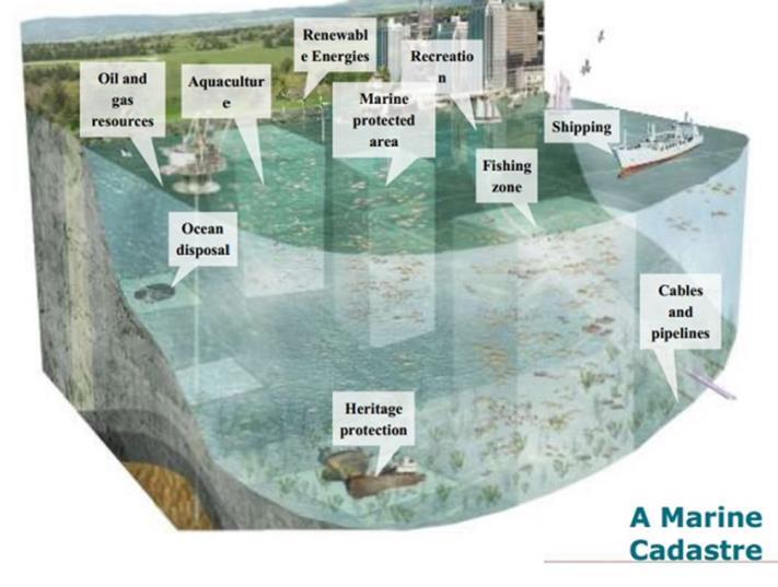
5 Definitions: Marine Cadastre A marine cadastre is a system to enable the boundaries of maritime rights and interests to be recorded, spatially managed and physically defined in relationship to the boundaries of other neighboring or underlying rights and interests. (attributed to Robertson, 1999) Source: Marine Cadastre describes the location and spatial extent of rights, restrictions and responsibilities in the marine environment E.Balla
6 Definitions: Marine Cadastre The scope of the Marine Cadastre includes: Delineation The identity of entities with statutory content Scientific information (e.g.geology, hydrology, biology etc.) Other marine related information that has boundary implications Marine Parcel Source: Jaap Zevenbergen 2004 Who is holding the right? What does the right consist of? How has the right been acquired? Where is the right located?. NB: transparency is key issue Cadastral Parcel 6
7 Definitions: Marine Spatial Data Infrastructure Marine Spatial Data Infrastructure (MSDI) is the component of an SDI that encompasses marine geographic and business information in its widest sense. This would typically include seabed topography, geology, marine infrastructure, resources utilisation, administrative and legal boundaries, areas of conservation, marine habitats and oceanography (IHO, 2011). Marine Cadastre is considered as a base layer of a MSDI with fundamental information relating to maritime boundaries and associated rights, responsibilities and restrictions Marine Administration System for the administration of rights, restrictions and responsibilities in the marine environment with the spatial dimension facilitated by the Marine SDI. seamless SDI that includes data from land, coast and marine environments to enable the access and sharing of data to avoid 7 management gaps in the coastal zone
8 Definitions: Marine Spatial Planning Maritime Spatial Planning is about planning when and where human activities take place at sea to ensure these activities are as efficient and sustainable as possible. Maritime Spatial Planning is a process by which the MS s authorities analyse, plan and organise human activities in marine areas to achieve ecological, economic and social objectives 8
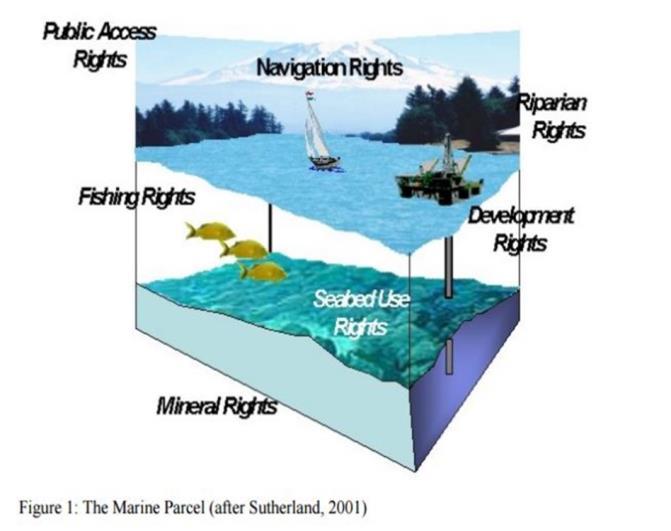
9 Definitions: MC, MSDI, MSP MC = LC Marine Parcel 9

 Ocean s value more than 24trillion USD (WWF, 2015) The annual Gross")

10 The international context: facts & figures WORLD Over 3 billion people depend on marine and coastal resources for their livelihoods The global oceans-based economy is estimated at between USD 3-6 trillion/year (WWF, 2015) Ocean s value more than 24trillion USD (WWF, 2015) The annual Gross marine product, the equivalent of a country s GDP would make the oceans the world s 7th largest economy At least 90% of the volume of global trade is seaborne. 10
")
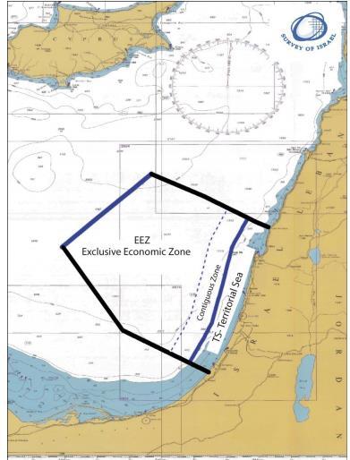
11 International context: UNCLOS «The Constitution of the Sea» 1982 (Voting) /1994 (Came into force) 320 Articles/ 9 Annexes 25 Articles related to Geoinformatics 167 parties (166 states and the EU) 11


12 International context E.Balla

 Economy")


13 The European context: Facts & Figures European Union Geography ( km coastline, 5 seas and 2 oceans, 2/3 of European borders are seafront) Economy (5,4 million jobs, EU s Blue Economy GVA 500 billion Euros/year, 75% of the EU s external trade & 37% of EU s internal trade is seaborne EU ratified the UNCLOS in EU s EEZ area is almost 25% larger than the terrestrial area. E.Balla
14 The European context: The path from IMP to Blue Growth Reaffirmed maritime dimension of EU 1 st phase ( ) IMP 2 nd phase ( ) Blue Growth Maritime s contribution to achieving Europe s 2020 goals for smart, sustainable, inclusive growth Basic components Cross sectoral implementation tools 1)Blue Growth focus areas Marine Knowledge MSP Maritime Surveillance 2) Marine Knowledge, MSP, Marit.Surveillance Components to provide knowledge Legal certainty security 3)Sea basin strategies E.Balla


15 The European context: EU s initiatives on Marine Data 8 portals 2020 objective to provide a seamless multi-resolution digital map of the entire seabed of European waters (Phase III ) 15 Represents 160 organisations


16 4. The European context: EMODnet Human Activities portal E.Balla June

, (Sentinel-1B/2016) Sentinel-3: high-accuracy optical, radar and altimetry data for marine and land")

17 The European context: EU s initiatives on Marine Data COPERNICUS MARINE ENVIRONMENT MONITORING SERVICE provides regular and systematic reference information on the state of the physical oceans and regional seas. Sentinel-1: all-weather, day and night radar imagery for land and ocean services. The first satellite (Sentinel-1A/2014), (Sentinel-1B/2016) Sentinel-3: high-accuracy optical, radar and altimetry data for marine and land services; variables such as sea-surface topography, sea- and land-surface temperature, ocean colour and land colour with high-end accuracy and reliability. The first Sentinel-3 satellite was planned for launch in Sentinel-6 : high accuracy altimetry for measuring global sea-surface height, primarily for operational oceanography and for climate studies. Sentinel-6A is planned for launch in 2020.


18 The European context: EU s initiatives on Marine Data Several INSPIRE data themes relevant to the marine community Differences between INSPIRE and EMODnet in terms of scope, policy frameworks and technologies «Topographic and Cadastral Reference» and «Facilities, utilities and public services» of INSPIRE are relevant to Human Activities Portal of EMODnet INSPIRE? EMODnet E.Balla

19 State of Play in Europe Is there any Marine Information System in your country? 32% 68% Yes No Questionnaire 19 out of 28 EU Member States participated in the survey 13 MS out of 19 have developed a kind of MIS (either in stage of operation or on pilot basis/project) 19


20 State of Play of Marine Cadastre in Europe GERMANY Navigation Spatial Planning Bathymetry Shipping Oceanography Water Pollution Geology Biology Marine Environment Model Forecast WFD Assesment Reserves Wind Parks Lines Federal waterways Bathymetry Pollutants Waterlevel Geology Eutrophication Human Activities 20

21 FRANCE French Hydrographic Organization 21

")

22 FRANCE France Watch Video at Pilot project - 2 test areas (a 40km area near Marseille, between Carry-le-Rouet and la Ciotat) focused on the marine public area and the marine uses 4km area near the city of Sete >focus on coasts and lagoons 22


23 5. State of Play of Marine Cadastre in Europe Estonia Estonia>No Marine Cadastre but Marine Areas Application within the Geoportal of the Estonian Land Board INSPIRE compliant and encompasses data for the whole Estonian Marine Area in the Baltic Sea Datasets : sea depths, buoys, beacons, cables, wrecks etc. Estonian Maritime Administration Denmark Denmark>rapid pace towards the development of an MSDI Expansion of the land cadastre to the sea territory: registration of buildings at the sea territory in the Danish Cadastre!! 23


24 SWEDEN 5. State of Play of Marine Cadastre in Europe 24
25 Several countries outside of the European continent, with strong ocean and sea interests, have shown a rapid pace towards the development of the Marine Cadastre since 1994, when the UNCLOS came into effect. Sophisticated Web GIS/Mapping Services based on open and re-use data policies and the concept of the Multipurpose cadastre in the international initiatives. However evidence shows focus on recording than registering. Land cadastre is partially a good analogy to the Marine Cadastre The Marine Cadastre is a base layer of the Marine SDI, offering fundamental information relating to maritime boundaries and associated rights, responsibilities, and restrictions regularly updated and maintained. Marine Cadastre is not MSP but it s the most important underpinning data sources to enable its implementation. However the concept of MSP has been broadened gradually encompassing some of the features and effects that a traditional land registry & cadastre usually has. Main conclusions I 25
26 Main conclusions II No reference to the notion of Marine Cadastre in the EU regulatory framework. Emphasis on the MSP tool to achieve legal certainty in the marine environment, to boost the Blue Economy sector and to reduce transactions costs. Some data to a Marine Cadastre are recorded under the theme Human Activities in the EMODNET portal. However the information provided through EMODNET portal is of a static nature, more suitable for other purposes (e.g. statistics, planning, research) rather than secure of rights. Therefore ΕΜΟDnet Human Activities MC. A wide array of actors and stakeholders are involved in the management of the marine environment and production of marine data, though the competent national Land Registry and Cadastre organizations have been scarcely so far engaged. Existing Marine Information Systems (either operative or on pilot basis) are developed either on the concept of EMODNET or to serve other needs (ICZM strategy, MSP, marine areas delimitation) but not a Marine Cadastre. 26

")


SDI")
27 Why would we need a Marine Cadastre? (from a land based perspective) Reduces conflicts Sovereign state rights European harmonization Legal certainty to 3R Security for credit Delimitation of UNCLOS marine areas Supports environmental management Integration of land -sea interaction Basic layer of (M)SDI Blue Economy May increase public revenues 27 E.Balla 2016
28 Next Steps I Current state of play Limited priority CV-partner organizations for follow up project Dissemination of results at several fora/authorities and organizations Interest is present but so far no solid pull to discuss a follow up Nordic & Baltic countries have demonstrated specific interest MSP communities and related WG started to show interest on MC Way forward Follow up publication covering: recent developments in MC Formulation of concrete reasons why a MC Perform Need analysis based on stakeholder interview Develop questionnaire Analyse the outcome of the Q s Decide for any further action Research on funding possibilities (Horizon2020, COST, Interreg) 28
29 Next Steps II What would be the goals Integration of available information Now many data sets on human activity at sea Checking and enforcing Marine Spatial Plans Improve accessibility of data (ref EMODnet) Ref land registry and cadastre portal at land Search for specific owner of a property at sea is impossible How to organize the follow up? Follow up by CV-partners Team up with already running initiatives Continued dialogue with the EU Commission 29


")


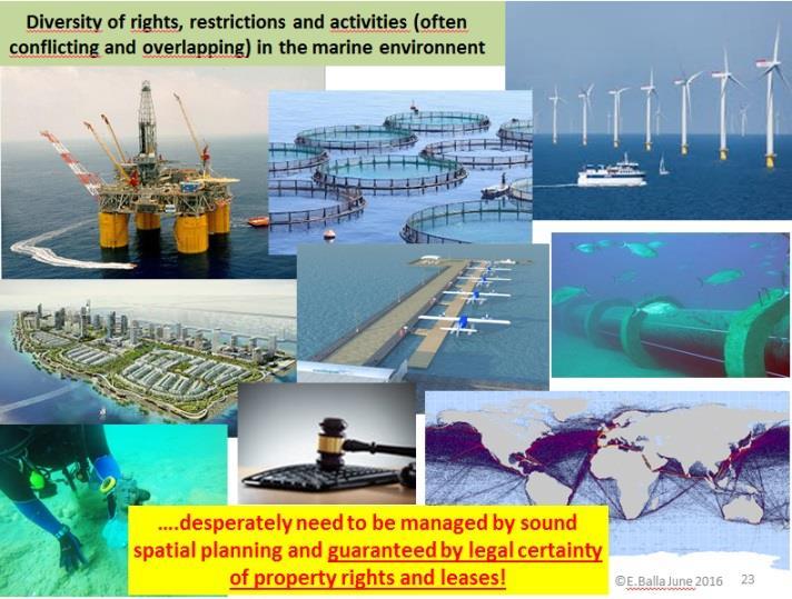
30 Diversity of rights, restrictions and activities (often conflicting and overlapping) in the marine environment.desperately need to be managed by sound spatial planning and guaranteed by legal certainty of property rights and leases! 30


31 Thank you for your attention! Evangelia Balla "How inappropriate to call this planet Earth when it is quite clearly Ocean? attributed to Arthur C. Clarke Rik Wouters
The Multipurpose Marine Cadastre A Tool for Planning & Decision Making in the Marine Environment
 The Multipurpose Marine Cadastre A Tool for Planning & Decision Making in the Marine Environment Christine Taylor Minerals Management Service (MMS) Brian Smith NOAA Coastal Services Center Maurice Hill
Cadastre and Land Registration in Europe
 Annex A: Questionnaire 2007 for Information Resource Cadastre and Land Registration in Europe Introduction This questionnaire is based on the EuroGeographics vision document 'Cadastre and Land Registration
Designing for transparency and participation in the Hellenic Cadastral Project
 Designing for transparency and participation in the Hellenic Cadastral Project Dr. Dimitris Rokos Director of Planning and Investments, Hellenic National Cadastre and Mapping Agency S.A. Table of Contents
Croatian SDI: a Tool for Accelerated Development of the Geo-Conscious Society
 STATE GEODETIC ADMINISTRATION Croatian SDI: a Tool for Accelerated Development of the Geo-Conscious Society Prof.Dr.Sc. Željko Bačić, Mr.Sc. Ljerka Rašić FIG Working Week 2009 - Surveyors Key Role in Accelerated
Challenges for the multi purpose cadastre
 Jens RIECKEN, Markus SEIFERT, Germany Key words: Multi purpose cadastre, 3d-cadastre, land use, SDI, solar cadastre SUMMARY Over the past 30 years, with the progress of information technologies the development
National Spatial Data Infrastructure development in Republic of Macedonia
 National Spatial Data Infrastructure development in Republic of Macedonia Sonja Dimova, state advisor for geomatics AGENCY FOR REAL ESTATE CADASTRE September 6-th, 2017, Strasbourg AREC competence for
Marine Spatial Data Infrastructure (MSDI) & The Marine Cadastre Application. April 10, 2018
 & The Marine Cadastre Application. April 10, 2018") Marine Spatial Data Infrastructure (MSDI) & The Marine Cadastre Application April 10, 2018 A Collaborative Pilot Project Vision of CHS: A framework of geographic data, metadata, users and tools Intent
Marine Spatial Data Infrastructure (MSDI) & The Marine Cadastre Application April 10, 2018 A Collaborative Pilot Project Vision of CHS: A framework of geographic data, metadata, users and tools Intent
Participants of the Ministerial Meeting on Housing and Land Management on 8 October 2013 in Geneva
 Summary At its meeting on 2 April 2012, the Bureau of the Committee on Housing and Land Management of the United Nations Economic Commission for Europe agreed on the need for a Strategy for Sustainable
Digitalisation of the Real Property Rights Towards Spatially enabled E-Government
 Digitalisation of the Real Property Rights Towards Spatially enabled E-Government Lise Schroeder, Bent Hulegaard Jensen, Esben Munk Soerensen & Line Hvingel Istanbul, Turkey 25 june 201 Overview Introduction
UNECE workshop on: Cadastral and real estate registration systems: Economic information for real estate markets in the UNECE region
 UNECE workshop on: Cadastral and real estate registration systems: Economic information for real estate markets in the UNECE region Roma, 5-65 6 May 2011 Maurizio Festa Agenzia del Territorio Head of Statistics
Land and Geographic Information, an Important Part of the Infrastructure in Sweden
 Land and Geographical Information Land and Geographic Information, an Important Part of the Infrastructure in Sweden Land and Geographic Information, an Important Part of the Infrastructure In Sweden Bo
LIS a motivation for SDI initiative
 Eric Mwaikambo Ardhi University Dar es Salaam Tanzania Overview Status of LIS in Tanzania Relationship between SDI and LIS Spatial Standards LIS a motivation for SDI initiative Conclusion & Recommendations
1st Regional INSPIRE Forum 4th Croatian NSDI and INSPIRE Day
 1st Regional INSPIRE Forum 4th Croatian NSDI and INSPIRE Day State of Play EULIS Rik Wouters Managing Director EULIS Programme What is EULIS EULIS is renewed: LINE For who is EULIS? Why EULIS? Projects
International funding projects in Republic Geodetic Authority
 International funding projects in Republic Geodetic Authority Serbia: Republic Geodetic Authority Workshop Exploring Funding Instruments for NMCA 7-8 November 2012 Republic Geodetic Authority Republic
Topographic Signs Important Context of 3D Cadastre
 STATE GEODETIC ADMINISTRATION Gruška 20,10 000 Zagreb, Croatia Delft University of Technology Faculty of Architecture and the Built Environment Department OTB GIS Technology Section Topographic Signs Important
PROJECT INFORMATION DOCUMENT (PID) APPRAISAL STAGE Report No.: PIDA Project Name. Region Country Sector(s) Theme(s)
 APPRAISAL STAGE Report No.: PIDA Project Name. Region Country Sector(s) Theme(s)") Public Disclosure Authorized Public Disclosure Authorized Public Disclosure Authorized Public Disclosure Authorized Project Name Region Country Sector(s) Theme(s) Lending Instrument Project ID Borrower(s)
Public Disclosure Authorized Public Disclosure Authorized Public Disclosure Authorized Public Disclosure Authorized Project Name Region Country Sector(s) Theme(s) Lending Instrument Project ID Borrower(s)
INSPIRE Thematic Working. Cadastral parcels. September 2008
 INSPIRE Thematic Working Cadastral parcels September 2008 The INSPIRE context The INSPIRE Directive Its aim is to build the INfrastructure for Spatial InfoRmation in Europe The INSPIRE Directive has been
PROTOCOL ASDI ARCTIC SPATIAL DATA INFRASTRUCTURE PROJECT KICK-OFF MEETING
 1(9) Friday, 15 October 2010 PROTOCOL ASDI ARCTIC SPATIAL DATA INFRASTRUCTURE PROJECT KICK-OFF MEETING Point of time: 09.00 October 14 11.15 October 15, 2010 Locality: Rue du Nord 76, 1000 Brussels, BELGIUM
Spatial Data Infrastructure in Sweden
 Spatial Data Infrastructure in Sweden Hans-Erik WIBERG, Sweden Key words: ABSTRACT Sweden was one of the first countries to address Data Infrastructure matters and have during several decades developed
Quality Improvement of the Real Estate Cadastre in Serbia
 , Serbia Key words: quality improvement, real estate information, quality assurance, Serbia SUMMARY The concept of cadastral modernization in the Republic of Serbia was defined in 1992, and it is being
Report and update from Working Group A on Core Data
 JOINT UN-GGIM: EUROPE ESS MEETING ON THE INTEGRATION OF STATISTICAL AND GEOSPATIAL INFORMATION LUXEMBOURG 31 MARCH 2017 Report and update from Working Group A on Core Data François Chirié, Dominique Laurent,
Land Tenure and Geospatial Data and Technology
 Land Tenure and Geospatial Data and Technology Ioana Bouvier E3/Land and Urban, USAID Senior Geospatial Analyst January 23, 2018 January 23, 2018 1 OUTLINE 1. Overview of geospatial data and technology
Use of data in Ukraine for sustainable economic growth. Oleksandr Maliuk State Service of Ukraine for Geodesy, Cartography and Cadastre
 Use of data in Ukraine for sustainable economic growth Oleksandr Maliuk State Service of Ukraine for Geodesy, Cartography and Cadastre Kehl, 2017 Content of the presentation Ukraine & StateGeoCadastre:
Cadastre: definitions
 Introduction New vision towards a multipurpose cadastral system to support land management in Morocco Moha EL-AYACHI, El Hassane SEMLALI, Mohamed ETTARID, Driss TAHIRI, Institut Agronomique et Vétérinaire
The Challenge to Implement International Cadastral Models Case Finland 1
 The Challenge to Implement International Cadastral Models Case Finland 1 Tarja MYLLYMÄKI and Tarja PYKÄLÄ, Finland Key words: cadastre, modelling, LADM, INSPIRE SUMMARY Efforts are currently made to develop
Smart Infrastructure Benefits and Key Players from a Global Perspective
 Smart Infrastructure Benefits and Key Players from a Global Perspective Spatial@gov 2010 October 5-7 Canberra Jude Wallace and Abbas Rajabifard Centre for Spatial Data Infrastructures and Land Administration
Cadastral Parcels in INSPIRE. Lisbon, 27 February 2013
 Cadastral Parcels in INSPIRE Lisbon, 27 February 2013 Dominique.laurent@ign.fr Plan INSPIRE context The modeling approach for theme Cadastral Parcels Implementation of INSPIRE theme Cadastral Parcels Context
Information contained
 Government Information (Public Access) Act 2009 (GIPA Act) LPI Information Guide 1. Introduction and contents of this guide The Land and Property Information s (LPI) Information Guide tells you in general
PROJECT INFORMATION DOCUMENT (PID) CONCEPT STAGE Report No.: AB3229 Project Name. Land Registry and Cadastre Modernization Project Region
 CONCEPT STAGE Report No.: AB3229 Project Name. Land Registry and Cadastre Modernization Project Region") PROJECT INFORMATION DOCUMENT (PID) CONCEPT STAGE Report No.: AB3229 Project Name Land Registry and Cadastre Modernization Project Region EUROPE AND CENTRAL ASIA Sector Central government administration
PROJECT INFORMATION DOCUMENT (PID) CONCEPT STAGE Report No.: AB3229 Project Name Land Registry and Cadastre Modernization Project Region EUROPE AND CENTRAL ASIA Sector Central government administration
INTEGRATED LAND ADMINISTRATION SYSTEM PROJECT PREPARATION (IBRD Advance no. P459-HR) TERMS OF REFERENCE
 TERMS OF REFERENCE") INTEGRATED LAND ADMINISTRATION SYSTEM PROJECT PREPARATION (IBRD Advance no. P459-HR) TERMS OF REFERENCE SERVICE PROVISION FOR THE SUPPORT TO THE NATIONAL SPATIAL DATA INFRASTRUCTURE (NSDI) DEVELOPMENT
INTEGRATED LAND ADMINISTRATION SYSTEM PROJECT PREPARATION (IBRD Advance no. P459-HR) TERMS OF REFERENCE SERVICE PROVISION FOR THE SUPPORT TO THE NATIONAL SPATIAL DATA INFRASTRUCTURE (NSDI) DEVELOPMENT
The Cadastre of Public-law Restrictions on Landownership in Switzerland
 The Cadastre of Public-law Restrictions on Landownership in Switzerland The new official land registry information system Maurice Barbieri, CLGE President Zagreb, 26.November 2015 Utility Cadastre Seminar
Presented at the FIG Congress 2018, May 6-11, 2018 in Istanbul, Turkey
 Presented at the FIG Congress 2018, May 6-11, 2018 in Istanbul, Turkey 5 Bibliometric Analysis of Articles Presented Under Commission 7: A Case of the 25th Fig Congress in Malaysia in 2014 Zeynel Abidin
Building a European Spatial Data Infrastructure: The Role of EuroGeographics
 Building a European Spatial Data Infrastructure: The Role of EuroGeographics Richard Kirwan President of EuroGeographics 1st Congress on Cadastre in the EU 1 Presentation overview EuroGeographics - the
FIG Commission 3 Spatial Information Management. Report of Activities 2009
 Appendix to item 10.3 Report to the 33 rd General Assembly FIG Congress in Sydney, Australia 2010 FIG Commission 3 Spatial Information Management Report of Activities 2009 1. General Since 2007, FIG Commission
Agenda. Introduction to participants First Meeting UN-GGIM - GROUP OF EXPERTS ON LAND ADMINISTRATION AND MANAGEMENT UN-GE-LAM
 First Meeting UN-GGIM - GROUP OF EXPERTS ON LAND ADMINISTRATION AND MANAGEMENT Kees de Zeeuw, The Netherlands Chair Mahashe Chaka, Lesotho Co-Chair Brent Jones, ESRI (USA) -Rapporteur Agenda Opening Introduction
Land Administration Infrastructures for Sustainable Development
 The Global Challenges Land Administration Infrastructures for Sustainable Development Prof. Stig Enemark Department of Development and Planning Aalborg, University, Denmark INTERNATIONAL CONFERENCE ON
The Bathurst Declaration on Land Administration for Sustainable Development
 United Nations and International Federation of Surveyors The Bathurst Declaration on Land Administration for Sustainable Development The Story The cumulative evolution of society s land administration
Cadastral Parcels in the context of INSPIRE
 Cadastral Parcels in the context of INSPIRE Gyula IVÁN Institute of Geodesy, Cartography & Remote Sensing, HUNGARY Open Symposium on Environment and Land Administration Big Works for the Defence of Territory
UNPLANNED URBAN DEVELOPMENT
 National Technical University of Athens School of Rural and Surveying Engineering UNPLANNED URBAN DEVELOPMENT Chryssy A Potsiou, Lecturer NTUA chryssyp@survey.ntua.gr UNECE WPLA WORKSHOP EFFECTIVE AND
Tracking the progress in land policy formulation in francophone Africa countries. Claire GALPIN, France
 Tracking the progress in land policy formulation in francophone Africa countries Presented at the FIG Working Week 2016, May 2-6, 2016 in Christchurch, New Zealand Case of Algeria, Senegal, Cote d Ivoire
Seventh Session of the United Nations Committee of Experts on Global Geospatial Information Management
 Report of the Forum P a g e 1 Seventh Session of the United Nations Committee of Experts on Global Geospatial Information Management Report of the Forum Secure Land Rights and Smart Cities - Making It
Greetings from Denmark. Property Rights, Restrictions and Responsibilities - A Global Land Management Perspective. Wonderful Copenhagen
 Property Rights, Restrictions and Responsibilities - A Global Land Management Perspective Greetings from Denmark 43,000 sq km Prof. Stig Enemark President Aalborg University, Denmark Aalborg Copenhagen
INSPIRE Core Data. Questionnaire for EuroGeographics Cadastre & Land Registration KEN members
 INSPIRE Core Data Questionnaire for EuroGeographics Cadastre & Land Registration KEN members 1. Theme Cadastral Parcels 1.1 Geographic extent Q1: in your country, what is the geographic extent of cadastral
THE 2030 AGENDA, CITIES AND URBAN GOVERNANCE A CENTRAL ROLE FOR LAND AND GEOSPATIAL INFORMATION
 THE 2030 AGENDA, CITIES AND URBAN GOVERNANCE A CENTRAL ROLE FOR LAND AND GEOSPATIAL INFORMATION Abbas Rajabifard Immediate Past President and Executive Board Member, GSDI Association Director, Centre for
Housing Ireland A Journal for Irish Housing Professionals
 www.cih.org Learn with us. Improve with us. Influence with us. Housing Ireland A Journal for Irish Housing Professionals A Chartered Institute of Housing Publication Winter 2013 Issue 03 Inside this issue:
Coastal Zone Management Land Administration Capacity Building
 Closing Address Prof. Stig Enemark President 6th FIG Regional Conference Coastal Areas and Land Administration - Building the Capacity San José, Costa Rica, 12 15 November 2007 Three Main Themes Coastal
Surveyors Qualifications
 Surveyors Qualifications Præludium Surveyors Qualifications Lars Jansson, Director Lantmäteriet Henning Elmstrøm, President DdL 1 Agenda 1. Introduction 2. Basic framework conditions for cadastral systems
KHANALIBAYLI UNECE WPLA
 UNECE Working Party on Land Administration The role of the UNECE Working Party on Land Administration (WPLA) in the promotion and improvement of land administration and land management in the UNECE region
Lessons for federated countries that have state land registries the Australian experience
 Lessons for federated countries that have state land registries the Australian experience Ian Williamson Centre for SDI and Land Administration Department Infrastructure Engineering University of Melbourne
Amie Figueiredo WPLA Secretariat Wednesday, 16 October 2014 Vienna, Raiffeisen Forum
 WPLA cooperation with related international organisations and interregional cooperation Amie Figueiredo WPLA Secretariat Wednesday, 16 October 2014 Vienna, Raiffeisen Forum International cooperation International
Supporting Capacity Development for Sustainable Land Administration Infrastructures
 THE EIGHTH UNITED NATIONS REGIONAL CARTOGRAPHIC CONFERENCE FOR THE AMARICAS (UNRCCA) 27 June 1 July 2005, United Nations Headquarters, New York Supporting Capacity Development for Sustainable Land Administration
The Governance of Land Use
 The Governance of Land Use Country fact sheet Sweden The planning system Levels of government and their responsibilities Sweden is a unitary country with 3 levels of government; the national level, 21
Chapter 3: A Framework for a National Land Information Infrastructure
 Chapter 3: A Framework for a National Land Information Infrastructure Brian Marwick Overview As a federated county, Australia s land administration systems are state and territory based. These systems,
Centre for SDIs and Land Administration Department of Geomatics Spatial systems to support sustainable development
 Centre for SDIs and Land Administration Department of Geomatics MODERN CADASTER and LAND ADMINISTRATION تهران-مرداد 1386 2014 ..... 2 ماه Centre for SDIs and Land Administration Department of Geomatics
Support to Implementation of Multipurpose Cadastral Information system in Vietnam
 Support to Implementation of Multipurpose Cadastral Information system in Vietnam Lennart JOHANSSON and Per SÖRBOM, Sweden Key words: Land Registration, Land Information, Land Administration, SWOT analyse,
The Digital Cadastral Database and the Role of the Private Licensed Surveyors in Denmark
 IRISH INSTITUTE OF SURVEYORS, DUBLIN INSTITUTE OF TECHNOLOGY, 23 NOVEMBER 2005 PUBLISHED IN IIS NEWS, WINTHER 2006. The Digital Cadastral Database and the Role of the Private Licensed Surveyors in Denmark
Report No.: ISDSA15389
 Public Disclosure Authorized Public Disclosure Authorized Public Disclosure Authorized Public Disclosure Authorized 0 o Date ISDS Prepared/Updated: 12-ct-2015 INTEGRATED SAFEGUARDS DATA SHEET APPRAISAL
UN-HABITAT s Mission and Vision. Sustainable urban development Adequate shelter for all
 GLTN contributes to the implementation of pro poor land policies to achieve secure land rights for all www.gltn.net GLTN Secretariat, facilitated by PO Box 30030, Nairobi 00100, Kenya Tel: +254 20 762
Land Management Procedures and Informal Constructions in Cyprus. Marilena Theodorou, Land Surveyor, Cyprus, Dr Chryssy Potsiou, Lecturer NTUA, Greece
 Land Management Procedures and Informal Constructions in Cyprus Marilena Theodorou, Land Surveyor, Cyprus, Dr Chryssy Potsiou, Lecturer NTUA, Greece FIG Working Week 2008 Integrating Generations Objectives
STATUS REPORT
 Working Group 3 Land Administration STATUS REPORT 2006-2009 2009 Prof Ian Williamson (Chair) Mr Ahmad Fauzi Nordin (Vice Chair) Assoc. Prof Abbas Rajabifard (Vice Chair) 18th UNRCC-AP Conference Bangkok
Securing Land Rights for Broadband Land Acquisition for Utilities in Sweden
 Securing Land Rights for Broadband Land Acquisition for Utilities in Sweden Marija JURIC and Kristin LAND, Sweden Key words: broadband, land acquisition, cadastral procedure, Sweden SUMMARY The European
Scenic Nepal. Land Administration Systems. Outline of Presentation. Interests in land. Rights: Registration and security of tenure positions
 Scenic Nepal Land Administration Systems Managing Rights, Restrictions, and Responsibilities in Land Prof. Stig Enemark President Aalborg University, Denmark SURVEY DEPARTMENT KATHMANDU, NEPAL. 16 FEBRUARY
Building Integrated Land Information Systems and Development of NSDI
 Stig JÖNSSON, Sweden Key words: Land administration, land information systems, property formation, spatial data infrastructure, Inspire, institutional cooperation SUMMARY Lantmäteriet the Swedish agency
Good Land Governance for the 2030 Agenda
 Good Land Governance for the 2030 Agenda Addis Ababa, Ethiopia 20-22 April, 2014 Role of Geospatial Information in Good Land Policy and Governance Oumar Sylla UN-Habitat/GLTN oumar.sylla@unhabitat.org
A Geocoded Cadastral Fabric as a Precondition for a Sustainable Land Management System
 A Geocoded Fabric as a Precondition for a Sustainable Land Management System Gottfried KONECNY, Germany; J.P. LAUZON, Canada; Abdul Salam MOHAMMED, India Key words: SDI,, Parcel Boundaries, GPS-GNSS, Land
Aspect of preliminary activities in the function of supporting NSDI
 Sonja DIMOVA, Republic of Macedonia Key words: e-governance, geospatial data, NSDI, INSPIRE, metadata SUMMARY The successful establishment of the NSDI in the true sense of the word cannot be performed
Standardization in the Cadastral Domain. Sub Working Group 1: Legal Aspects
 Standardization in the Cadastral Domain Sub Working Group 1: Legal Aspects Framework 10 participants 8 countries 2 sessions Updates from the different countries (mainly as to the legal aspects of cadastre)
Importance of Spatial Data Infrastructure in the UNECE Region. Amie Figueiredo INSPIRE Conference 2016 Barcelona, 26 September 2016
 Importance of Spatial Data Infrastructure in the UNECE Region. Amie Figueiredo INSPIRE Conference 2016 Barcelona, 26 September 2016 United Nations Economic Commission for Europe 56 member States in Europe,
Spatially Enabled Society Role of the Cadastre
 armasuisse Bundesamt für Landestopografie swisstopo Swiss Federal Directorate for Cadastral Surveying Spatially Enabled Society Role of the Cadastre XXIV FIG International Congress 2010 FIG-Task Force
Land Administration And Spatial Data Infrastructures
 Land Administration And Spatial Data Infrastructures Ian WILLIAMSON, Donald GRANT and Abbas RAJABIFARD Centre for SDIs and Land Administration Department of Geomatics University of Melbourne, Australia
EXPANDING AVAILABILITY OF BROADBAND ACCESS AND ADOPTION
 Single point information Ilija Kepevski Agency for Electronic Communications Regional Conference for Europe EXPANDING AVAILABILITY OF BROADBAND ACCESS AND ADOPTION 28-29 September 2015 - Budva, Montenegro
BULGARIAN CADASTRE A GUARANTEE FOR THE OWNERSHIP RIGHTS IN IMMOVABLE PROPERTIES
 4 TH INTERNATIONAL CONFERENCE RECENT PROBLEMS IN GEODESY AND RELATED FIELDS WITH INTERNATIONAL IMPORTANCE February 28 - March 2, 2007, Inter Expo Centre, Sofia, Bulgaria BULGARIAN CADASTRE A GUARANTEE
Minimum Educational Requirements
 Minimum Educational Requirements (MER) For all persons elected to practice in each Member Association With effect from 1 January 2011 1 Introduction 1.1 The European Group of Valuers Associations (TEGoVA)
Land Information System as new instrument for Land Administration: Case Examples. Mike Cheremshynskyi Consultant, Land Administration Expert
 Land Information System as new instrument for Land Administration: Case Examples Mike Cheremshynskyi Consultant, Land Administration Expert Background Growth of population and fast urbanization in many
Croatian NSDI - An example of AGISEE country web-page. Vlado Cetl and Miljenko Lapaine
 Croatian NSDI - An example of AGISEE country web-page Vlado Cetl and Miljenko Lapaine Introduction 2/18 Guidelines AGISSE Country Pages should provide an overview of the situation of SDIs in the countries
Understanding the Land Management Paradigm
 FIG COM 7 SYMPOSIUM ON INNOVATIVE TECHNOLOGIES FOR LANDADMINISTRATION 19 25 June 2005, Madison, Wisconsin, USA. Understanding the Land Management Paradigm Prof. Stig Enemark Vice-President of FIG Department
Overview of PCGIAP-WG3 and Spatially Enabled Government
 Working Group 3 3 rd Land Administration Forum Overview of and Spatially Enabled Government Abbas Rajabifard Vice Chair, Established in 2000 based on a Resolution from the 15th UNRCC-AP in Malaysia. With
Commission 7, Land Administration and IT. Paul van der Molen INTERNATIONAL INSTITUTE FOR GEO-INFORMATION SCIENCE AND EARTH OBSERVATION
 Commission 7, Land Administration and IT Paul van der Molen INTERNATIONAL INSTITUTE FOR GEO-INFORMATION SCIENCE AND EARTH OBSERVATION FIG Commission 7 on cadastre and land management Study Visits (e.g.
The agenda for a Group of Experts on Land Administration and Management within the United Nations
 Presented at the FIG Working Week 2016, May 2-6, 2016 in Christchurch, New Zealand The agenda for a Group of Experts on Land Administration and Management within the United Nations Kees de Zeeuw, Kadaster
CADASTRE 2014: New Challenges and Direction
 CADASTRE 2014: New Challenges and Direction Anna KRELLE and Abbas RAJABIFARD, Australia Key words: Cadastre, Cadastre 2014, Land Administration SUMMARY Land and land related activities form part of the
Germany on the way to a 4D-Cadastre
 Germany on the way to a 4D-Cadastre Dr. Jens Riecken (DVW Vicepresident), Ulrich Gruber, Dr. Markus Seifert (DVW WG Geoinformation) TS 9.1 4D Cadastre, Land Domain Models & Concepts 1 Content About my
The Added Value of Geospatial Information in Disaster and Risk Management: A Case Study on the 2009 Flooding in Namibia
 The Added Value of Geospatial Information in Disaster and Risk Management: A Case Study on the 2009 Flooding in Namibia Summary Tessa Anne Belinfante, M.Sc. VU University Amsterdam Objective and Approach
Egyptian Nationwide Title Cadastre System
 Kholoud SAAD, Egypt Key words: Cadastre, Registration, Urban, Rural, National Cadastre, Automation, reengineering. SUMMARY With growing need for integrated information, Enterprise Solutions has become
Qualification Snapshot CIH Level 3 Certificate in Housing Services (QCF)
") Qualification Snapshot CIH Certificate in Housing Services (QCF) The Chartered Institute of Housing (CIH) is an awarding organisation for national qualifications at levels 2, 3 and 4. CIH is the leading
Qualification Snapshot CIH Certificate in Housing Services (QCF) The Chartered Institute of Housing (CIH) is an awarding organisation for national qualifications at levels 2, 3 and 4. CIH is the leading
Benchmarking Cadastral Systems Results of the Working Group 7.1
 Benchmarking Cadastral Systems Results of the Working Group 7.1 Jürg KAUFMANN, Switzerland Key words: ABSTRACT In 1998, FIG-Commission 7 launched three new working groups for the period 1998-2002. Working
CADASTRE AND LAND REGISTER Following up their relationship
 CADASTRE AND LAND REGISTER Following up their relationship Jorge López ELRA Barcelona, 16th May 2014 Principles of relationship cadastre-land register Description of properties ( A ): huge interest Ownership
The means to identify trends and policy innovations for strengthening Land Governance
 Economy, Society and Climate change The Impact of mega trends in the Building Environment, Construction Industry and Real estate The means to identify trends and policy innovations for strengthening Land
LAUNCH OF CADASTRAL TEMPLATE 2.0
 LAUNCH OF CADASTRAL TEMPLATE 2.0 Dr. Daniel Steudler Scientific Associate, swisstopo Prof. Abbas Rajabifard Director Centre for SDIs and Land Administration, Melbourne University FIG-Commission 7, Annual
DOING BUSINESS Frederic Meunier EDBI Conference, Nairobi
 DOING BUSINESS 2016 Frederic Meunier EDBI Conference, Nairobi May 3 rd, 2016 How has the Registering Property indicator changed over time? Efficiency of land administration systems has always been measured:
Modelling Real Estate Business for Governance and Learning
 Modelling Real Estate Business for Governance and Learning Erik Stubkjær Aalborg University, Denmark FIG Workshop on e-governance, Knowledge Management and e-learning April 27-29 2006, Budapest, Hungary
Course Number Course Title Course Description
 Johns Hopkins Carey Business School Edward St. John Real Estate Program Master of Science in Real Estate and Course Descriptions AY 2015-2016 Course Number Course Title Course Description BU.120.601 (Carey
A Review and Perspective on Parcel Data Models for Urban Planning
 A Review and Perspective on Parcel Data Models for Urban Planning Yiqiang Ouyang Prof. Dr. Ilir Bejleri Department of Urban and Regional Planning University of Florida June 19-21, 2010 1 Content 1. Introduction
FIG Working group Valuation and Real estate management through Fin-tech. Manohar Velpuri
 FIG Working group 9.2 - Valuation and Real estate management through Fin-tech Manohar Velpuri Introduction Projects Timeline and working group project updates II plenary - ISO TC 307 report Integration
Spatial Enablement and the Response to Climate Change and the Millennium Development Goals
 Spatial Enablement and the Response to Climate Change and the Millennium Development Goals Prof. Stig Enemark President Aalborg University, Denmark 18th UNITED NATIONS REGIONAL CARTOGRAPHIS CONFERENCE
E fficient L and A dministr ation E ncour ages P r oper ty M ar k ets. surveying companies at Project commencement. Key Messages
 Secur ing Pr oper ty R ights and I ncr easing R eal E state Pr oductivity in F Y R M acedonia Victoria Stanley, Denis Boskovski and Samantha De Martino Key Messages Before 2005, FYR Macedonia did not have
Developing a Performance Review Questionnaire for Hong Kong Cadastral Survey System
 Developing a Performance Review Questionnaire for Hong Kong Cadastral Survey System Haodong ZHANG and Conrad TANG, Hong Kong SAR, CHINA Key words: Fit-for-Purpose, Cadastral Surveying, Land Administration,
Proposals for Best Practice
 WPLA Fees & Charges in Cadastre and Registration Proposals for Best Practice Neil King United Kingdom WPLA Fees and Charges Study Best Practice This presentation offers an overview of a draft report that
National Technical University of Athens School of Rural and Surveying Engineering
 National Technical University of Athens School of Rural and Surveying Engineering INFORMAL SETTLEMENTS REAL ESTATE MARKET NEED FOR GOOD LAND ADMINISTRATION AND PLANNING FIG COM3, UNECE CHLM & WPLA JOINT
KEY REGISTERS AS BASE OF THE DUTCH SDI
 CO-151 KEY REGISTERS AS BASE OF THE DUTCH SDI BAKKER N.J. Kadaster, APELDOORN, NETHERLANDS This paper reports on the realisation of the Key Registers in the Netherlands as the foundation of the Dutch National
Land Tools for Tenure Security for All
 Land Tools for Tenure Security for All PROF. JAAP ZEVENBERGEN UNIVERSITY OF TWENTE - ITC 1 ST JUNE 2017 HELSINKI, FINLAND GLOBAL LAND CHALLENGES 70 % Dealing with the affordability issue - how to modernize