The agenda for a Group of Experts on Land Administration and Management within the United Nations
|
|
|
- Dwight Hutchinson
- 5 years ago
- Views:
Transcription
 Mahashe Chaka, LAA - Lesotho (Co-Chair UN-GE-LAM) Cecille Blake - USA (UN-GGIM")
1 Presented at the FIG Working Week 2016, May 2-6, 2016 in Christchurch, New Zealand The agenda for a Group of Experts on Land Administration and Management within the United Nations Kees de Zeeuw, Kadaster - The Netherlands (Chair UN-GE-LAM) Mahashe Chaka, LAA - Lesotho (Co-Chair UN-GE-LAM) Cecille Blake - USA (UN-GGIM Secretariat)


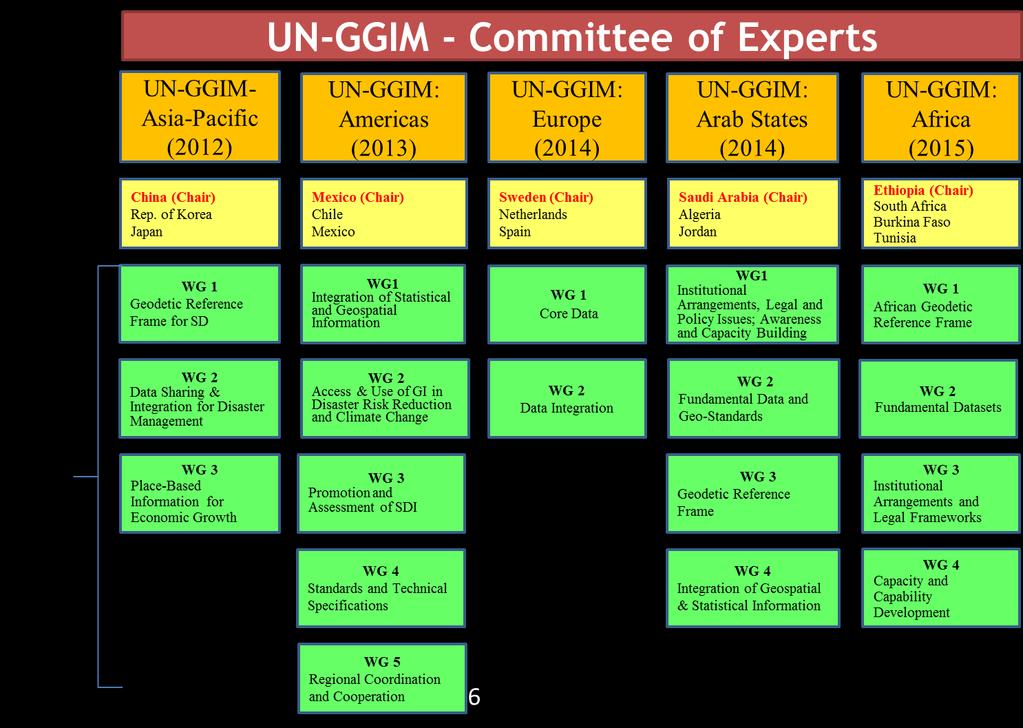
2 UN GGIM: Integration of worlds Statistics Mapping Remote Sensing Land Administration UN-GGIM and Land Administration and Management

3
4 UN GGIM aims at playing a leading role in setting the agenda for the development of global geospatial information and to promote its use to address key global challenges. It provides a forum to liaise and coordinate among Member States, and between Member States and international organizations. Expert Groups 1. United Nations Expert Group on the Integration of Statistical and Geospatial Information 2. The United Nations Expert Group on Land Administration and Management (UN-EG-LAM) Working Groups 1. Global Geodetic Reference Frame 2. Development of a Statement of Shared Principles for the Management of Geospatial Info 3. Global Map for Sustainable Development (GM4SD) 4. Trends in National Institutional Arrangements in Geospatial Information Management 5. Geospatial Information and Services for Disasters (WG-Disasters)
5 Objectives of UN-EG-LAM Play a leading role at the policy level by raising political awareness and highlighting the importance to decision makers of the need for timely and fit for purpose land administration and management and; Encourage the use of geospatial information tools and systems to improve the legal certainty of all citizens in the world with respect to the registration of the relation between people and land.

6 17 Goals, 169 targets, and a wide range of indicators Source: SDG s


7 Source: UN GGIM Greg Scott 17 Goals 169 Targets 230 Global Indicators Global Outputs and Reporting Official Aggregation and Integration into Indicator Framework by National Statistical Offices. Captures data integrity and validation. SDG metrics for measuring and monitoring progress. Data compiled and disaggregated by income, gender, age, race, ethnicity, migratory status, disability, geographic location, etc. National Data Integration Earth Observations and Monitoring National Spatial Data Infrastructure National Statistics, Accounts, Administrative Registers, Demographics Other Sources of Data, incl. Big Data National Information Systems Imagery Water/Ocean Land use/cover Observations In situ monitoring Air/Pollution Ecosystems Forest/Agriculture Climate Geodetic positioning Elevation Topography Land use & cover Transport/Infrastruct. Cadastre/Parcels Water & Oceans Cities & Settlements Administrative Bdys. Population Demographics Poverty Trade/Business Environment Labour/Economics Agriculture Disability/Gender Civil Registration & Vital Stats. Mobile phone Social media Sensors Automated devices Satellite imagery VGI Crowd sourcing?? Data Inputs Fundamental baseline data and new data sources Local to national social, economic and environmental conditions and circumstances SDG s and UN-GGIM


8 Land Administration Process Data acquisition Distribution Processing Rights Land administration is the process of determining, recording and disseminating of information about ownership, value and use of land when implementing land management policies. Assessment Inventory Land Purposes Source: LADM, ISO Land Adminsitration

9 Good, Chepa AND Fast

10


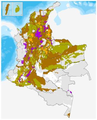
11 Land Tenure Atlas Colombia Namibia Surinam Land Tenure Atlas

12 class Classes of LADM LA_SpatialSource LA_LegalSpaceNetwork LA_LegalSpaceBuildingUnit LA_SpatialUnitGroup LA_Source LA_GroupParty LA_SpatialUnit LA_BoundaryFaceString LA_PartyMember LA_Administrativ esource LA_Party LA_RRR LA_Lev el LA_Point LA_BAUnit LA_Restriction LA_Responsibility LA_BoundaryFace LA_Mortgage LA_Right Standards (LADM / STDM)

")
13 Methods (Fit for Purpose, VGGT)
14 Infrastructures

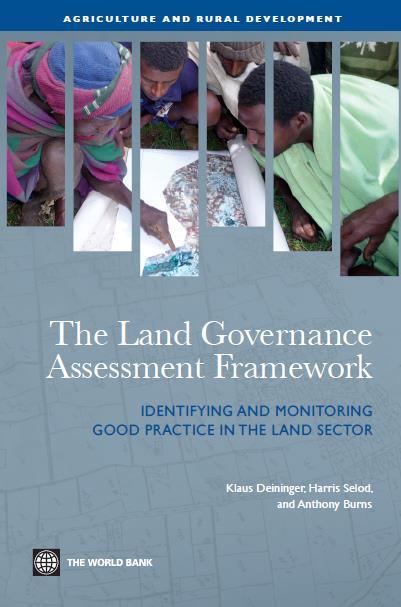
15 LGAF in 44 countries Completed: 33 Ongoing: 7 Prospective: 4 Source: World Bank in partnership with FAO, IFAD and UN-Habitat Land Governance Assessment Framework
16 Best Practices Visualise Speaking the language Using the existing tools Participation, inclusiveness Flexible approach Affordable Best Practices

17 Partnerships Global, national, community, professional based initiatives Shared ambitions Private sector role Partnerships

18 Leadership UN-GGIM Leadership


19 $ per parcel $ billion
20 Land rights for the world Data, knowledge & experience Standards (ISO, OGC, LADM/STDM) Methods & guidelines (Fit for Purpose LA, VGGT) Tools (UN, Open Source, commercial) Infrastructure (Governments, communities) Cases and best practices Indicators, targets, global insight Partnership, awareness, leadership & finance Conclusions
21 Functions UN-GE-LAM Provide a forum for coordination and dialogue among global experts from the land administration and geospatial communities with a view to advance the activities related to the administration and management, and strengthening the use of geospatial information for good land governance; Propose work plans, informed by broad global consultation, to address the main areas of focus identified by Member states while ensuring that there are no overlaps or duplication with other initiatives; Address governance, data management, institutional and technology adoption and sustainability issues related to the implementation and management of efficient land administration and management systems, and transparent, functioning land markets and; Undertake work that is able to contribute to the Sustainable Development Goals of the UN indicator process and other areas as appropriate including, access to land, property rights, ownership, land degradation, rapid urbanization, and climate change, in coordination with other expert entities.


22 High Level Forum Addis Ababa
23 High Level Forum Addis Ababa. invite international development partners, nongovernmental organizations, the private sector and industry to take collective action to include a geospatial component in all of their sectoral projects they are funding in order to significantly improve geographic coverage of land administration and management systems, and the availability and accessibility of authoritative and up-to-date geospatial and land information necessary for good land governance ;
24 Conclusions In order to achieve the SDG s good geospatial information management and sound land administration are important prerequisites. It is the momentum is right for the challenging but feasible ambition to have land rights for the world. The objective of UN-GGIM (UN-EG-LAM) is to play a leading role at the policy level, by raising awareness and to encourage the use of geospatial information management for land administration purposes. The UN GGIM High Level Forum declaration is promising and ambitious. Conclusions

25 Holland is cool Venue: 10 minutes airport, city centre, polders & tulips Schiphol Airport: over 300 direct destinations Fee: 550 Euro Smart surveyors for land and water management
Agenda. Introduction to participants First Meeting UN-GGIM - GROUP OF EXPERTS ON LAND ADMINISTRATION AND MANAGEMENT UN-GE-LAM
 First Meeting UN-GGIM - GROUP OF EXPERTS ON LAND ADMINISTRATION AND MANAGEMENT Kees de Zeeuw, The Netherlands Chair Mahashe Chaka, Lesotho Co-Chair Brent Jones, ESRI (USA) -Rapporteur Agenda Opening Introduction
A new era: Dynamic Information Management
 A new era: Dynamic Information Management Professional and Institutional Developments Kees de Zeeuw MSc Director Kadaster International The Netherlands Affiliate member s perspective 45 affiliates from
Fit-For-Purpose Land Administration, Standards and Interoperability
 Fit-For-Purpose Land Administration, Standards and Interoperability Christiaan Lemmen Kadaster International University of Twente/ITC UN GGIM Seminar Effective Land Administration Deqing China September,
Fit-For-Purpose what is it?
 FIG Commission 7 Annual Meeting 2016 Working Group 7.1 Fit-For-Purpose Land Administration Christiaan Lemmen October, 24th 2016 Coimbra, Portugal Fit-For-Purpose what is it? Fit-for-purpose: The systems
UN GGIM LAUNCHES A GROUP OF EXPERTS ON LAND ADMINISTRATION AND MANAGEMENT. KEES DE ZEEUW 1
 UN GGIM LAUNCHES A GROUP OF EXPERTS ON LAND ADMINISTRATION AND MANAGEMENT KEES DE ZEEUW 1 Kees.dezeeuw@kadaster.nl MAHASHE CHAKA 2 Mahashe.Chaka@laa.org.ls CECILLE BLAKE 3 Blake1@un.org 1 Kadaster - Cadastre,
The ISO/TC 211 Land Administration Domain Model (LADM)
") Geographic information/geomatics The ISO/TC 211 Land Administration Domain Model (LADM) Harry Uitermark/Editor LADM Kadaster/ITC, The Netherlands International Organization for Standardization (ISO) A
Geographic information/geomatics The ISO/TC 211 Land Administration Domain Model (LADM) Harry Uitermark/Editor LADM Kadaster/ITC, The Netherlands International Organization for Standardization (ISO) A
Seventh Session of the United Nations Committee of Experts on Global Geospatial Information Management
 Report of the Forum P a g e 1 Seventh Session of the United Nations Committee of Experts on Global Geospatial Information Management Report of the Forum Secure Land Rights and Smart Cities - Making It
Good Land Governance for the 2030 Agenda
 Good Land Governance for the 2030 Agenda Addis Ababa, Ethiopia 20-22 April, 2014 Role of Geospatial Information in Good Land Policy and Governance Oumar Sylla UN-Habitat/GLTN oumar.sylla@unhabitat.org
THE NEED FOR APPROACHES AND TECHNOLOGY OF TOMORROW
 THE NEED FOR APPROACHES AND TECHNOLOGY OF TOMORROW KEES DE ZEEUW, CHRISTIAAN LEMMEN and BERNY KERSTEN Cadastre, Land Registry and Mapping Agency - Kadaster, The Netherlands Kees.dezeeuw@kadaster.nl Paper
BOOSTING THE REGISTRATION OF LAND RIGHTS IN STEP WITH THE SUSTAINABLE DEVELOPMENT GOALS
 BOOSTING THE REGISTRATION OF LAND RIGHTS IN STEP WITH THE SUSTAINABLE DEVELOPMENT GOALS KEES DE ZEEUW Cadastre, Land Registry and Mapping Agency - Kadaster, The Netherlands Kees.dezeeuw@kadaster.nl CHRISTIAAN
Economic and Social Council 6 July 2018
 1 ADVANCE UNEDITED VERSION UNITED NATIONS E/C.20/2018/12/Add.1 Economic and Social Council 6 July 2018 Committee of Experts on Global Geospatial Information Management Eighth session New York, 1-3 August
UN-GGIM Expert Group on Land Administration and Management Expert Group Meeting, Delft, The Netherlands 14 & 15 March, 2017
 UN-GGIM Expert Group on Land Administration and Management Expert Group Meeting, Delft, The Netherlands 14 & 15 March, 2017 BACKGROUND DOCUMENT The Delft Expert Group Meeting This two-day meeting of the
Fit-For-Purpose Land Administration: Guiding Principles FACILITATED BY:
 Fit-For-Purpose Land Administration: Guiding Principles 1. GLTN overview - GLTN BRIEFING AND PROGRAMME 2. Geospatial Data - Sustainable Development - 3. Fit-for-purpose Land Administration Guiding Principles
Annual Meeting II/2016 FIG Commission 7 Cadastre & Land Management. Report
 Annual Meeting II/2016 FIG Commission 7 Cadastre & Land Management Report 1 Structure Chair G. Schennach (AT) V-Chair for communications, social media, web Hyunsook LEE (KR) WG 7.1 Fit-For-Purpose LA Ch.
Global Eradication of Infectious Diseases
 Global Security of Tenure Campaign the Time of Rights Dr Robin McLaren Land Professional Know Edge Limited Location Information Innovation COMMISSION 7 ANNUAL MEETING, COIMBRA, PORTUGAL OCTOBER 2016 1
From LADM/STDM to a spatially enabled society: a vision for Harry UITERMARK, Peter VAN OOSTEROM, Jaap ZEVENBERGEN and Christiaan LEMMEN
 From LADM/STDM to a spatially enabled society: a vision for 2025 Harry UITERMARK, Peter VAN OOSTEROM, Jaap ZEVENBERGEN and Christiaan LEMMEN Introduction (1) Vision is a co-production Founding fathers
AFRICA REGIONAL NETOWORK
 Facing the Global Agenda - The Role of Land Professionals Prof. Stig Enemark FIG Honorary President Aalborg University, Denmark AFRICA REGIONAL NETOWORK Challenges and Opportunities in Facing the SDG s:
Deqing International Seminar on United Nations Global Geospatial Information Management Effective Land Administration September 2018
 Provisional Annotated Agenda 08:00 a.m. 09:00 a.m. Registration of Participants Thursday, 27th September 2018 09:00 a.m. 10:00 a.m. Joint Official Opening Session Joint official opening session of the
From LADM/STDM to a spatially enabled society: a vision for Harry UITERMARK, Peter VAN OOSTEROM, Jaap ZEVENBERGEN and Christiaan LEMMEN
 From LADM/STDM to a spatially enabled society: a vision for 2025 Harry UITERMARK, Peter VAN OOSTEROM, Jaap ZEVENBERGEN and Christiaan LEMMEN Introduction (1) Presentation is a coproduction Founding fathers
UNECE Working Party on Land Administration UNECE WPLA. Report on the work of the Bureau of the Working Party
 UNECE Working Party on Land Administration UNECE WPLA Report on the work of the Bureau of the Working Party 10 th Session of UNECE WPLA Geneva, 8 9 March 2017 UNECE Working Party on Land Administration
GLTN LAND TOOLS -SOME EXAMPLES-
 GLTN LAND TOOLS -SOME EXAMPLES- Dr. Jaap Zevenbergen University of Twente What are GLTN Land Tools? GLTN considers that a tool is a practical method to achieve a defined objective in a particular context.
The Bathurst Declaration on Land Administration for Sustainable Development
 United Nations and International Federation of Surveyors The Bathurst Declaration on Land Administration for Sustainable Development The Story The cumulative evolution of society s land administration
Land Markets and Land Rights in support of the Millennium Development Goals
 Land Markets and Land Rights in support of the Millennium Development Goals A Global Perspective Prof. Stig Enemark President Aalborg University, Denmark 3rd LAND ADMINISTRATION FORUM FOR THE ASIA AND
LAND TENURE IN ASIA AND THE PACIFIC CHALLENGES, OPPORTUNITIES AND WAY FORWARD
 LAND TENURE IN ASIA AND THE PACIFIC CHALLENGES, OPPORTUNITIES AND WAY FORWARD Workshop on Land Administration and Management 20th United Nations Regional Cartographic Conference for Asia and the Pacific
How Big is Global Insecurity of Tenure?
 Presented at the FIG Working Week 2016, May 2-6, 2016 in Christchurch, New Zealand Know Edge Limited Location Information Innovation How Big is Global Insecurity of Tenure? Dr Robin McLaren Know Edge Ltd,
The Message FIG-WB Partnership on Land Governance in Support of the Global Agenda
 FIG-WB Partnership on Land Governance in Support of the Global Agenda Prof. Stig Enemark, Denmark President 2007-2010 Mr. Teo Chee Hai, Malaysia President Elect 2011-2014 WORLD BANK LAND GROUP, WASHINGTON,
UN-HABITAT SCROLL OF HONOUR AWARD CALL FOR NOMINATIONS
 2018 UN-HABITAT SCROLL OF HONOUR AWARD CALL FOR NOMINATIONS 02 UN-Habitat Scroll of Honour Award Call for nominations for the UN-Habitat Scroll of Honour Award on the occasion of the global observance
The Surveyor and the Sustainable Development Goals
 The Surveyor and the Sustainable Development Goals Ghana Institute of Surveyors 12 th Surveyors Week Accra, Ghana, 20 th - 24 th February 2017 www.fig.net/ Dr Diane Dumashie, FRICS FIG Vice President How
Importance of Spatial Data Infrastructure in the UNECE Region. Amie Figueiredo INSPIRE Conference 2016 Barcelona, 26 September 2016
 Importance of Spatial Data Infrastructure in the UNECE Region. Amie Figueiredo INSPIRE Conference 2016 Barcelona, 26 September 2016 United Nations Economic Commission for Europe 56 member States in Europe,
Land Administration in support of the Global Agenda: Current FIG Policies
 Land Administration in support of the Global Agenda: Current FIG Policies Prof. Stig Enemark President Aalborg University, Denmark FIG COMMISSION 7 ANNUAL MEETING VERONA, ITALY, SEPTEMBER 2008 Current
Creation Land Administration in Formal and Informal Environment. FIG Commission 7 Working Group 1
 Creation Land Administration in Formal and Informal Environment András OSSKÓ, Hungary Key words: land administration, informal land tenure, customary tenure, sustainable Development. SUMMARY FIG Commission
FIG Commission 7 Cadastre and Land Management
 1. Title Appendix to item 13 FIG Commission 7 Cadastre and Land Management Cadastre and Land Management 2. Terms of Reference Work Plan 2015 2018 Commission 7 deals with all issues of land rights and land
Amie Figueiredo WPLA Secretariat Wednesday, 16 October 2014 Vienna, Raiffeisen Forum
 WPLA cooperation with related international organisations and interregional cooperation Amie Figueiredo WPLA Secretariat Wednesday, 16 October 2014 Vienna, Raiffeisen Forum International cooperation International
Scenic Nepal. Land Administration Systems. Outline of Presentation. Interests in land. Rights: Registration and security of tenure positions
 Scenic Nepal Land Administration Systems Managing Rights, Restrictions, and Responsibilities in Land Prof. Stig Enemark President Aalborg University, Denmark SURVEY DEPARTMENT KATHMANDU, NEPAL. 16 FEBRUARY
Land Tools for Tenure Security for All
 Land Tools for Tenure Security for All PROF. JAAP ZEVENBERGEN UNIVERSITY OF TWENTE - ITC 1 ST JUNE 2017 HELSINKI, FINLAND GLOBAL LAND CHALLENGES 70 % Dealing with the affordability issue - how to modernize
LIS a motivation for SDI initiative
 Eric Mwaikambo Ardhi University Dar es Salaam Tanzania Overview Status of LIS in Tanzania Relationship between SDI and LIS Spatial Standards LIS a motivation for SDI initiative Conclusion & Recommendations
UN-HABITAT s Mission and Vision. Sustainable urban development Adequate shelter for all
 GLTN contributes to the implementation of pro poor land policies to achieve secure land rights for all www.gltn.net GLTN Secretariat, facilitated by PO Box 30030, Nairobi 00100, Kenya Tel: +254 20 762
Land and the New Urban Agenda EGM June 2016
 EGM June 2016 Filiep Decorte Deputy Director New York Liaison Office UN-Habitat 2 August 2016 ROLE OF LAND IN URBAN DEVELOPMENT The New Urban Agenda is about people People need a place to live. Place means
EXPLORING OPTIONS FOR STANDARDISATION OF PROCESSES AND TRANSACTIONS IN LAND ADMINISTRATION
 EXPLORING OPTIONS FOR STANDARDISATION OF PROCESSES AND TRANSACTIONS IN LAND ADMINISTRATION CHRISTIAAN LEMMEN (1),(2), EVA-MARIA UNGER (2), PETER VAN OOSTEROM (3), MOHSEN KALANTARI (4) AND KEES DE ZEEUW
Marine Spatial Data Infrastructure (MSDI) & The Marine Cadastre Application. April 10, 2018
 & The Marine Cadastre Application. April 10, 2018") Marine Spatial Data Infrastructure (MSDI) & The Marine Cadastre Application April 10, 2018 A Collaborative Pilot Project Vision of CHS: A framework of geographic data, metadata, users and tools Intent
Marine Spatial Data Infrastructure (MSDI) & The Marine Cadastre Application April 10, 2018 A Collaborative Pilot Project Vision of CHS: A framework of geographic data, metadata, users and tools Intent
FIG Working group Valuation and Real estate management through Fin-tech. Manohar Velpuri
 FIG Working group 9.2 - Valuation and Real estate management through Fin-tech Manohar Velpuri Introduction Projects Timeline and working group project updates II plenary - ISO TC 307 report Integration
Low Cost Cadastral Data Aquisition?
 Low Cost Cadastral Data Aquisition? Jacobus Meijer and Christiaan Lemmen (Netherlands): 21 May 2011 Abstract Spatial Cadastral Data (Mapping) Participatory Development Some low cost approaches in cadastral
THE 2030 AGENDA, CITIES AND URBAN GOVERNANCE A CENTRAL ROLE FOR LAND AND GEOSPATIAL INFORMATION
 THE 2030 AGENDA, CITIES AND URBAN GOVERNANCE A CENTRAL ROLE FOR LAND AND GEOSPATIAL INFORMATION Abbas Rajabifard Immediate Past President and Executive Board Member, GSDI Association Director, Centre for
KHANALIBAYLI UNECE WPLA
 UNECE Working Party on Land Administration The role of the UNECE Working Party on Land Administration (WPLA) in the promotion and improvement of land administration and land management in the UNECE region
Linking the Land Information Systems in the Philippines Using the LADM as a Global Schema
 Linking the Land Information Systems in the Philippines Using the LADM as a Global Schema Romer Kristi ARANAS, Rhodora GONZALEZ and Louie Balicanta, Philippines Key words: Digital cadastre, e-governance,
National Technical University of Athens School of Rural and Surveying Engineering
 National Technical University of Athens School of Rural and Surveying Engineering INFORMAL SETTLEMENTS REAL ESTATE MARKET NEED FOR GOOD LAND ADMINISTRATION AND PLANNING FIG COM3, UNECE CHLM & WPLA JOINT
The LADM and the Continuum of Land Rights
 CheeHai TEO, Malaysia and Christiaan Lemmen, the Netherlands Key words: LADM, Continuum of Land Rights, Voluntary Guidelines, Spatial Enabled Societies SUMMARY The development of the Land Administration
Country Profile for the Cadastre of the Czech Republic Based on LADM
 Karel JANEČKA and Petr SOUČEK, Czech Republic Key words: Country profile, LADM, GeoInfoStrategy SUMMARY In 2014 the New Civil Code entered into force in the Czech Republic. This Act addresses several aspects
Greetings from Denmark. Property Rights, Restrictions and Responsibilities - A Global Land Management Perspective. Wonderful Copenhagen
 Property Rights, Restrictions and Responsibilities - A Global Land Management Perspective Greetings from Denmark 43,000 sq km Prof. Stig Enemark President Aalborg University, Denmark Aalborg Copenhagen
Key Registers in Finland and some views of Cadastre 2035
 Presented at the FIG Working Week 2016, May 2-6, 2016 in Christchurch, New Zealand Key Registers in Finland and some views of Cadastre 2035 FIG Working Week, Christchurch New Zealand May, the 3rd, 2016
The Profession between Cadastre and Citizen
 The Profession between Cadastre and Citizen Gerda Schennach, Austria Chair of FIG Commission 7 1 A human right UN DECLARATION OF HUMAN RIGHTS Article 17 par (1) Everyone has the right to own property alone
IMPROVING GOVERNANCE OF TENURE IN UNECE REGION: FAO/WORLD BANK/UNECE/EU JRC PARTNERSHIP
 IMPROVING GOVERNANCE OF TENURE IN UNECE REGION: FAO/WORLD BANK/UNECE/EU JRC PARTNERSHIP RUMYANA TONCHOVSKA, GULNARA ROLL, KATHRINE KELM FAO of the UN, Rome, Italy, Rumyana.Tonchovska@fao.org UNECE, Geneva,
Results of UN-Habitat s work in Angola, Ethiopia, Mozambique and Rwanda
 Country Presentation for the CPR Committee Meeting Results of UN-Habitat s work in Angola, Ethiopia, Mozambique and Rwanda Presented by the Regional Office for Africa 21 March 2018 Background The Regional
Good Governance and Regulatory Frameworks Lessons from the AU Agenda on Land
 Good Governance and Regulatory Frameworks Lessons from the AU Agenda on Land Joan Kagwanja Keynote, High Level Policy Dialogue Fourth High Level Forum on Global Geospatial Information Management (GGIM)
Modernizing Land Administration Systems
 Presented at the FIG Congress 2018, May 6-11, 2018 in Istanbul, Turkey Modernizing Land Administration Systems B r e n t J o n e s P E, PLS E s r i Land Administration Systems GIS is the Technology Platform
CONCEPT NOTE EFFECTIVE LAND ADMINISTRATION IN AFRICA TRAINING WORKSHOP
 CONCEPT NOTE EFFECTIVE LAND ADMINISTRATION IN AFRICA TRAINING WORKSHOP Innovative Concepts, Tools and Practices for Effective Land Administration Land Conference Pre-Conference Workshop Advocating & Implementing
The Added Value of Geospatial Information in Disaster and Risk Management: A Case Study on the 2009 Flooding in Namibia
 The Added Value of Geospatial Information in Disaster and Risk Management: A Case Study on the 2009 Flooding in Namibia Summary Tessa Anne Belinfante, M.Sc. VU University Amsterdam Objective and Approach
FURTHER STANDARDISATION IN LAND ADMINISTRATION
 FURTHER STANDARDISATION IN LAND ADMINISTRATION CHRISTIAAN LEMMEN Cadastre, Land Registry and Mapping Agency, The Netherlands Chrit.Lemmen@Kadaster.NL PETER VAN OOSTEROM Delft University of Technology,
TCP PROJECT AGREEMENT SUPPORT GOVERNMENT IN FORMULATION OF A NATIONAL AND GENDER SENSITIVE LAND POLICY GUIDED BY THE VGGT PRINCIPLES
 TCP PROJECT AGREEMENT SUPPORT GOVERNMENT IN FORMULATION OF A NATIONAL AND GENDER SENSITIVE LAND POLICY GUIDED BY THE VGGT PRINCIPLES THE PROBLEM Insecure tenure rights Property rights contestation Poor
Key Concepts, Approaches and Tools for Strengthening Land Tenure Security
 Key Concepts, Approaches and Tools for Strengthening Land Tenure Security Dr. Samuel Mabikke Land & GLTN Unit / UN-Habitat Urban CSO Cluster Learning Exchange on Strengthening Land Tenure Security for
LOW-COST LAND INFORMATION SYSTEM FOR SUSTAINABLE URBAN DEVELOPMENT
 Presented at the FIG Congress 2018, May 6-11, 2018 in Istanbul, Turkey LOW-COST LAND INFORMATION SYSTEM FOR SUSTAINABLE URBAN DEVELOPMENT Case Examples in Kenya and Zambia Presented by John Gitau Land
Cadastre a role model for Private-Public-People-Partnership
 Cadastre 4.0 - a role model for Private-Public-People-Partnership Gerda Schennach, Austria Chair of FIG Commission 7 1 Who owns... buildings? the mountains? land? forests? the sea? infrastructure? 2 From
Esri Middle East and Africa User Conference. December Abu Dhabi, UAE. Land Administration. Mark Baker
 Esri Middle East and Africa User Conference December 10 12 Abu Dhabi, UAE Land Administration Mark Baker Our Agenda 0900 0930 Welcome Mark Baker, Esri 0930 1030 New Directions The New Addressing System
Participants of the Ministerial Meeting on Housing and Land Management on 8 October 2013 in Geneva
 Summary At its meeting on 2 April 2012, the Bureau of the Committee on Housing and Land Management of the United Nations Economic Commission for Europe agreed on the need for a Strategy for Sustainable
G. Schennach / Chair Commission 7. Common Vision Conference 5-6 Oct 2017, Vienna, Austria
 Cadastre 4.0 - Integrating the community for global security on land tenure Gerda Schennach, Austria Chair of FIG Commission 7 1 200 years of innovation Fiscal Legal Local Digital Taxation Land Tenure
EXPERIENCES FROM THE KENYAN PROCESS
 EXPERIENCES FROM THE KENYAN PROCESS Contents: 1) Introduction: Kenya 2) Current Land Administration Practices 3) Consequences of Poor Practice 4) Context of Land Policy Formulation in Africa 5) Kenya National
Spatial Data Infrastructure for knowledge sharing
 , THE NETHERLANDS Key words: SDI, knowledge sharing, people profit planet, Kadaster, system of key registers, good governance, e-government, spatially enabled society, GIDEON SUMMARY Today s global challenges
UNPLANNED URBAN DEVELOPMENT
 National Technical University of Athens School of Rural and Surveying Engineering UNPLANNED URBAN DEVELOPMENT Chryssy A Potsiou, Lecturer NTUA chryssyp@survey.ntua.gr UNECE WPLA WORKSHOP EFFECTIVE AND
The importance of changes in land surveyors education
 András OSSKÓ Key words: land administration, roles of land surveyors, extended education, lifelong learning SUMMARY It s a world wide experience, especially in developed countries that the interest in
FIG-WB Forum on Land Administration and reform in Sub-Sahara Africa
 FIG-WB Forum on Land Administration and reform in Sub-Sahara Africa Chris Mnyanga Ministry of Lands UNITED REPUBLIC OF TANZANIA] FIG WORKING WEEK, Abuja, NIGERIA 2013-6-10 MAY 2013 Country at Glance UNITED
Towards LADM Country Cadastral Profile Case Poland
 Towards LADM Country Cadastral Profile Case Poland Jarosław BYDŁOSZ, Poland Key words: LADM, Country Profile, Cadastre, Poland SUMMARY The Geographic Information - Land Administration Domain Model was
Challenges for the multi purpose cadastre
 Jens RIECKEN, Markus SEIFERT, Germany Key words: Multi purpose cadastre, 3d-cadastre, land use, SDI, solar cadastre SUMMARY Over the past 30 years, with the progress of information technologies the development
The Social Tenure Domain Model STDM-Online
 Land and Poverty Conference 2016 Scaling up Responsible Land Governance 14-18 March, 2016 Washington, DC The Social Tenure Domain Model STDM-Online Arnulf Christl: metaspatial Cyprian Celebalo: UN Habitat
Commission 7 Cadastre and Land Administration. Work Plan
 Commission 7 Cadastre and Land Administration Work Plan 2011 2014 Appendix to item 17.7 1. Title Cadastre and Land Administration 2. Terms of Reference Commission 7 deals with land administration and land
Regional Training Workshop on Human Settlement Indicators for Arab States
 Regional Training Workshop on Human Settlement Indicators for Arab States Global Urban Observatory Unit Research and Capacity Development branch UN-HABITAT 3-5 July 2018 Cairo, Egypt Indicator 1.4.2 Secure
Flying high and Keeping the feet on the ground
 Building the Capacity The FIG Agenda and Achievements 2007-2010 Prof. Stig Enemark President FACING THE CHALLENGES BUILDING THE CAPACITY FIG CONGRESS, SYDNEY, AUSTRALIA, 11-16 APRIL 2010 The Agenda Building
Land Governance in Support of The Millennium Development Goals. Stig Enemark Paul van der Molen Robin McLaren
 Land Governance in Support of The Millennium Development Goals Stig Enemark Paul van der Molen Robin McLaren INV 1 - Land Governance in Support of the Millennium Development Goals Sydney, Australia, 11-16
Addressing Land Sector Opportunities with Geospatial Information in Nepal
 The 20th UNRCC-AP and the 4th UN-GGIM-AP 5-10 October 2015 Jeju Island, Republic of Korea Addressing Land Sector Opportunities with Geospatial Information in Nepal Krishna Raj BC Executive Director Land
Support to Implementation of Multipurpose Cadastral Information system in Vietnam
 Support to Implementation of Multipurpose Cadastral Information system in Vietnam Lennart JOHANSSON and Per SÖRBOM, Sweden Key words: Land Registration, Land Information, Land Administration, SWOT analyse,
GLTN Partner s Meeting November 1 st -6 th 2015
 GLTN Partner s Meeting November 1 st -6 th 2015 1. GLTN Partner s meeting 1.1 Follow-up and review of the post-2015 development Agenda: Clarissa Augustinus, UN-Habitat, discussed GLTN and GLII, saying
Cadastre: definitions
 Introduction New vision towards a multipurpose cadastral system to support land management in Morocco Moha EL-AYACHI, El Hassane SEMLALI, Mohamed ETTARID, Driss TAHIRI, Institut Agronomique et Vétérinaire
GLTN Tools and Approaches in Support of Land Policy Implementation in Africa
 GLTN Tools and Approaches in Support of Land Policy Implementation in Africa Jamal Browne (UN-Habitat), Jaap Zevenbergen (ITC), Danilo Antonio (UN-Habitat), Solomon Haile (UN-Habitat) Land Policy Development
Cadastre A Vision on Future Cadastral Systems
 Cadastre 2014 - A Vision on Future Cadastral Systems Jürg Kaufmann - 1 - CONTENTS ABOUT FIG ENVIRONMENT FOR THE DEVELOPMENT OF CADASTRE 2014 DEVELOPMENT OF CADASTRE 2014 PRINCIPLES OF CADASTRE 2014 EFFECTS
Building a European Spatial Data Infrastructure: The Role of EuroGeographics
 Building a European Spatial Data Infrastructure: The Role of EuroGeographics Richard Kirwan President of EuroGeographics 1st Congress on Cadastre in the EU 1 Presentation overview EuroGeographics - the
Spatially Enabled Society Role of the Cadastre
 armasuisse Bundesamt für Landestopografie swisstopo Swiss Federal Directorate for Cadastral Surveying Spatially Enabled Society Role of the Cadastre XXIV FIG International Congress 2010 FIG-Task Force
THE POWER OF DISAGGREGATED DATA TO PROMOTE EQUAL PROPERTY RIGHT AND MONITOR SDGs. Kecuk Suhariyanto Chief Statistician, BPS-Statistics Indonesia
 THE POWER OF DISAGGREGATED DATA TO PROMOTE EQUAL PROPERTY RIGHT AND MONITOR SDGs Kecuk Suhariyanto Chief Statistician, BPS-Statistics Indonesia Word Parliamentary Forum on Sustainable Development Bali,
STATUS REPORT
 Working Group 3 Land Administration STATUS REPORT 2006-2009 2009 Prof Ian Williamson (Chair) Mr Ahmad Fauzi Nordin (Vice Chair) Assoc. Prof Abbas Rajabifard (Vice Chair) 18th UNRCC-AP Conference Bangkok
World Habitat Day was established in 1985 by the United Nations General Assembly through Resolution 40/202, and was first celebrated in 1986.
 Expression of Interest 29 th January 2019 GLOBAL OBSERVANCE OF THE ANNUAL WORLD HABITAT DAY 2019 1. Introduction UN-Habitat is the United Nations programme working towards a better urban future. Its mission
Report and update from Working Group A on Core Data
 JOINT UN-GGIM: EUROPE ESS MEETING ON THE INTEGRATION OF STATISTICAL AND GEOSPATIAL INFORMATION LUXEMBOURG 31 MARCH 2017 Report and update from Working Group A on Core Data François Chirié, Dominique Laurent,
UNECE workshop on: Cadastral and real estate registration systems: Economic information for real estate markets in the UNECE region
 UNECE workshop on: Cadastral and real estate registration systems: Economic information for real estate markets in the UNECE region Roma, 5-65 6 May 2011 Maurizio Festa Agenzia del Territorio Head of Statistics
Presented at the FIG Congress 2018, May 6-11, 2018 in Istanbul, Turkey
 Presented at the FIG Congress 2018, May 6-11, 2018 in Istanbul, Turkey 5 Bibliometric Analysis of Articles Presented Under Commission 7: A Case of the 25th Fig Congress in Malaysia in 2014 Zeynel Abidin
RWANDA NATURAL RESOURCES AUTHORITY Department of Lands and Mapping
 RWANDA NATURAL RESOURCES AUTHORITY Department of Lands and Mapping National Land Use and Development Master Plan Presentation to National Forum on Sustainable Urbanisation in Support of EDPRS 2 Eng. Didier
Cadastral Template 2003
 PCGIAP-Working Group 3 "Cadastre" FIG-Commission 7 "Cadastre and Land Management" Cadastral Template 2003 The establishment of a cadastral template is one of the objectives of Working Group 3 "Cadastre"
New Technology for Cadastral Systems. Brent Jones, PE, PLS
 New Technology for Cadastral Systems Brent Jones, PE, PLS Benefits of Good Land Administration Key to addressing global challenges.. Secure Tenure Equitable Land and Property Taxation Support for Government
Keith Clifford Bell The World Bank -East Asia and the Pacific Region WASHINGTON D.C., USA
 Keith Clifford Bell The World Bank -East Asia and the Pacific Region WASHINGTON D.C., USA 4th Land Administration Forum for the Asia and Pacific Region Beyond Spatial Enablement October 5-7, 2011 Melbourne,
WORKSHOP ON TAX POLICY FOR DOMESTIC RESOURCE MOBILIZATION AND SEMINAR ON PROPERTY TAX REFORM: THE PHILIPPINE REGALA EXPERIENCE
 WORKSHOP ON TAX POLICY FOR DOMESTIC RESOURCE MOBILIZATION AND SEMINAR ON PROPERTY TAX REFORM: THE PHILIPPINE REGALA EXPERIENCE ADBI, Tokyo 20-23 February 2018 The Philippines is at a critical juncture.
Spatial Enablement and the Response to Climate Change and the Millennium Development Goals
 Spatial Enablement and the Response to Climate Change and the Millennium Development Goals Prof. Stig Enemark President Aalborg University, Denmark 18th UNITED NATIONS REGIONAL CARTOGRAPHIS CONFERENCE
8 th FIG Regional Conference Montevideo, Uruguay, November Call for Papers
 8 th FIG Regional Conference Montevideo, Uruguay, 26-29 November 2012 Dear Friend and Colleague, Call for Papers It is our privilege and honour to invite you to the 8 th FIG Regional Conference in Montevideo,
The computerised land reallotment process in Turkey and the Netherlands in multi-purpose land consolidation projects
 The computerised land reallotment process in Turkey and the Netherlands in multi-purpose land consolidation projects FIG Conference, 15 April 2010, Sydney Louisa J. M. Jansen (Netherlands), Mustafa Karatas,
Implementation of Fit for Purpose Land Administration in Nepal, in a post disaster context.
 Implementation of Fit for Purpose Land Administration in Nepal, in a post disaster context. Paula Dijkstra, Raja Ram Chhatkuli, Danilo Antonio, Eva-Maria Unger, Chrit Lemmen Wondimagegm Tesfaye, Shristee