CADASTRAL STUDIES (MGU1014 / MGHU1514)
|
|
|
- Julius Hudson
- 6 years ago
- Views:
Transcription
1 CADASTRAL STUDIES (MGU1014 / MGHU1514) WEEK 10-eCADASTRE SYSTEM AND MULTIPURPOSE CADASTRE SR DR. TAN LIAT CHOON
2 OUTLINE ecadastre System Multipurpose Cadastre 2
3 ecadastre SYSTEM 3
4 Computerisation Started as early as in 1985 Computer Assisted Land Survey System (CALS) CALS Johor in 1985 CALS Pahang in 1990 Mini CALS for other States in 1995 Objectives: Establish Digital Cadastral Database (DCDB) Provide digital cadastral data to Land Offices Facilitate faster production and updating of cadastral maps. 4
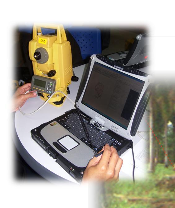
5 Computerisation Three (3) main Components Cadastral Data Management System (SPDK 1997); District Survey Offices Automation System (SAPD 2000) Total Station Survey System (STS 2002). 5
 from")

 e-srs 2")


6 Requisition of Survey (RS) from land Office 1 FIELD-TO-FINISH (State JUPEM Office) e-srs 2 e-skl RS registration and digital filing Field Computation data for Field Work preparation SAPD 3 Online data transfer of Field Computation data to District Offices 6
 4")


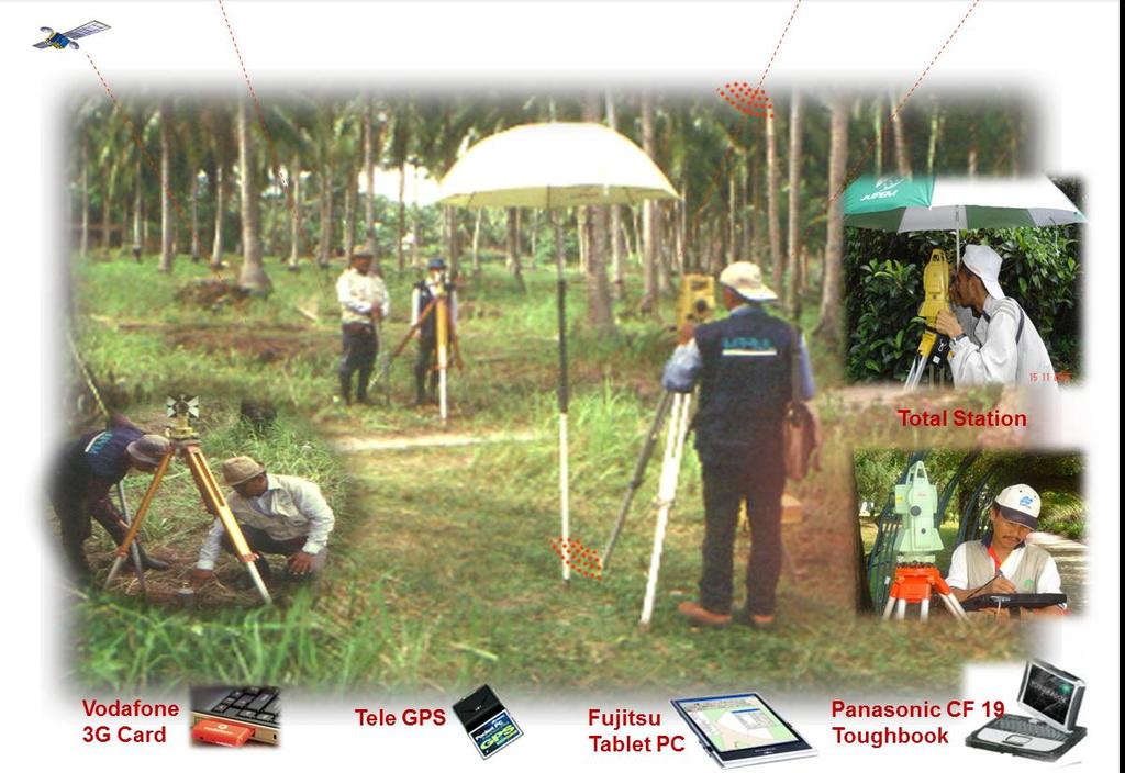
7 FIELD-TO-FINISH (DISTRICT OFFICES ABD FIELD WORK) 4 Online data transfer of Field Computation data from State JUPEM District Surveyor distribute survey job to Field Officers SAPD STS Determination of survey locality with TeleGPS Field Survey 5 Validated data uploaded online into State JUPEM District Surveyor validate data from field Field Officer processed and upload data into SAPD 7

 Online")


8 CPS FIELD-TO-FINISH (State JUPEM Office) Online data transfer between SAPD and SPDK Generate Calculation Volume and Certified Plan 6 DEP Director of Survey and Mapping approved Certified Plan with Digital Certification Digital Title Plan send to Land Offices Digital Certified Plan DCDB DCDB 7 SPEK Updating DCDB and SPID Image Library SPID 8
9 MALAYSIA 9th DEVELOPMENT PLAN ecadastre PROJECT 9
10 Objective Expedite the delivery system; Creation of the National Digital Cadastral Database (NDCDB); Creation of the Strata Database; Provide infrastructure and GIS-ready information; and Embark on satellite technology (GNSS) 10
11 Delivery System Expedite the delivery system, the strategy taken consists of the following: Change the existing survey procedure; Embark on the latest ICT approach in the cadastral survey; Strengthen the existing survey regulation and ruling; Integration with land related systems - Land Office s etanah, Licensed Land Surveyor Board s eljt and Ministry of Natural Resources and Environment s MyGDI. 11
12 NDCDB To create the National Digital Cadastral Database (NDCDB), the strategy taken consists of the following: Based on the successful implementation of the Melaka s NDCDB; A homogeneous and seamless database with survey accurate coordinate; Based on the national geocentric datum (GDM2000) ; Creation of Cadastral Control Infrastructure (CCI); Support the implementation of utility mapping. 12
13 Strata Database To create 3D Strata Database, the strategy taken consists of the following: Outsource the data capturing for 499,618 strata parcels; Embark on fully digital concept; Provide 3D information. 13
14 GIS To provide infrastructure and GIS-ready information, the strategy taken consists of the following: NDCDB will fully GIS-ready; Create additional layer in the GIS Layer Management System (eglms); Support the creation of multipurpose cadastre. 14
15 GNSS To embark on satellite technology (GPS) in cadastral survey, the strategy taken consists of the following: Use of GNSS in field survey; Utilization of MyRTKnet; Deployment of real-time data processing. 15
16 PROJECT ecadastre WORKFLOW 16


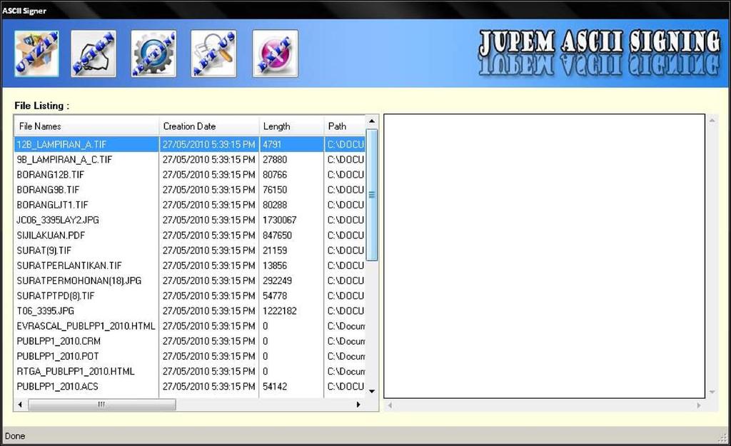
17 Application Modules Web GIS SUM JUPEM2U elodgement ekadasonline CSRS esim eborang Ecadasonline ekiosk ereporting emonitoring enotification Desktop GIS espid Database epu NDCDB epu eglms ejalan etownkg eadminbdy ehidrografi ebangunan ewarta egrid PDUSSM DRP epa epa(b) epa(s) epa(m) epa(w) eb1 eb4 epetakadas efee efee Field etsm Total Stn Survey ecrm GNSS Control essm Bldg Verification SUM LSA enotification GLMS Strata GIS Strata Strata 3D viewer Strata Data Entry LS emedmas Calibration esupport Maintenance ereporting ereporting Non GIS SPPK SPPK esigning everifier PKI 2D Barcode eannotation SPAK EDM/GPS Calibration SSO epki SPAK Security SPEK espek DB Merging eqc Lot overlap 17
")


 to Land")


18 LAND OFFICES Hardcopy Requisition of Survey (RS) ecadastre : WORKFLOW TITLE SURVEY STATE JUPEM 3 Licensed Land Surveyors (LS) Digital RS KOMMS Server 1 Registration of file Scanning related documents Generate epu Registration of file Import PU ASCII Generate epu 2 Updated epu Database Updated CSRS JUPEM2U Internet 4 RTK Net CRM Squad determine Cadstral Control point Updating Temp NDCDB Determine lot boundary Field data capturing Generating JUPEM ASCII Data validation Posting B1 Tiff (Digital Title Plan) to Land Offices CS digisign Temp NDCDB Updating NDCDB Generate B1 Tiff Validation Server Detail checking To accept/reject SUM Server LSA validation Preliminary checking To accept/reject 18
 Land Offices LJT PHASE")


")


19 Licensed Land Surveyors (LS) Land Offices LJT PHASE 1 Strata XML 16 Fieldbook ASCII Building Raster Plan Lst File Update Status ecadastre : WORKFLOW STRATA SURVEY JUPEM2U Internet JUPEM2U Internet HQ Query 7 Temp PDUSSM SUM In Order / Not In Order Advised to Land Offices and cc to LS, LJT, JUPEM HQ and Land Owner JUPEM2U CSRS 2 LAYER Provisional Block Strata Block STATE JUPEM System Generate PA(B) Number 6 CS/OD Digisign VERIFICATION DATA STANDARD PDUSSM UNIT JUPEM2U Internet 5 Upload FB ASCII 3 Register Strata File, Data Lodgement, Verifier, Updating Temp and Extraction Module Data Repository essm UNIT Strata Survey Module + Laser Ranging Survey Costing Module Temp PDUSSM Download 4 INSPEKTORAT UNIT 19


")

")

20 PHASE 2 ecadastre : WORKFLOW STRATA SURVEY STATE JUPEM essm UNIT PTG Final approval Generate 1 JUPEM2U Land Offices 13 KOMMS JUPEM2U Internet Update CSRS & Generate Scheme Number JUPEM2U Internet 12 2 PA(B) 10 SPID CSRS 11 TEMP PDUSSM 3 3D Strata Viewer 4 KOMMS B4/PA(B) CS B4 B4 Title Plan Preparation Module update Licensed Land Surveyors (LS) B4 Title Plan LS Login jupem2u & Endorsed PA(B) PDUSSM 9 8 Generate B4 Title Plan Acknoledgement to LS by sms 5 PA(B) Preparation Module 7 JUPEM2U Internet STANDARD PDUSSM UNIT 6 Generate PA(B) 20
21 ecadastre APPLICATION MODULES 21
22 Application Modules 1. NDCDB 2. JUPEM2U 3. CSRS 4. epu 5. esim 6. enotification 7. emonitoring 8. ereporting 9. ecrm 10. etsm 11. SUM 12. espek 13. eqc 14. DRP 15. efee 16. eglms 17. ecadasonline 18. esrms 19. PKI 20. esupport 21. ekomms 22. PDUSSM 23. essm 22
23 NATIONAL DIGITAL CADASTRAL DATABASE (NDCDB) 23
24 Background of NDCDB Digital Cadastral Database (DCDB) contains all information obtained from cadastral survey jobs related to boundaries of land parcels. The existing DCDB, which covers the entire country, was developed from historical survey data (conversion from hardcopy Certified Plans to digital) as well as from current survey jobs. Coordinates in the DCDB were obtained from several means and contain varying, unpredictable, and unquantified errors. 24
25 Background of NDCDB Uncertainties of surveyed values are typical, but errors are more common in some rural areas. To be able to support a modern cadastral system, an accurate positional record of the cadastre is imperative. The existing DCDB was not designed for this purpose. 25


26 Background of NDCDB DIFFERENT TYPES OF CADASTRAL COORDINATES RIGID COORDINATE PLOTTING COORDINATE SYSTEM COORDINATE Homogenous and Systematically Adjusted For cadastral map plotting purposes System/Software generated coordinate based on features location Rigid Coordinate Plotting Coordinate System Coordinate 26

27 Background of NDCDB System value Surveyed value 27
28 Background of NDCDB OLD AND NEW GEODETIC INFRASTRUCTURE: GEODETIC TRIANGULATION PENINSULAR MALAYSIA GPS BASED REFERENCE SYSTEM 6.50 G058 G071 G028 G035 G023 G G057 G040 G047 G031 G030 G044 G054 G003 G025 G032 G033 G077 G G059 G076 G021 G019 G017 G063 G048 G026 G013 G050 G027 G060 G069 G053 G072 G008 G G024 G022 G037 G034 G005 G G G041 G G001 G074 G075 G070 G061 G073 G009 G036 G011 G G052 G055G065 G068 G038 G020 G066 G012 G G051 G010 G G014 G049 G002 G G084 G043 G045 G056 P075 G018 G P4 28


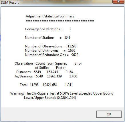
29 Background of NDCDB Non Rigorous Adjustment Technique for Coordinates Computation Bowditch Least Squares GPS GPS Bowditch adjustment distributes closing errors linearly but not able to provide a unique coordinates solution. Least Squares adjustment technique determine a unique set of coordinates for each boundary mark from a set of observed values (bearings & distances). 29
30 THE METHODOLOGY : NDCDB Establishment of CCI and State CCDB Establishing State Cadastral Control Infrastructure (CCI) Tie-Up of Selected Parcel Corners to CCI Repopulation & Re-coordination of DCDB with Survey Accurate Coordinates Development of State Cadastral Control Database (CCDB) Populating DCDB with Survey Accurate Coordinates Automated Re-Coordination System Study on Cadastral Survey Procedures Under CCS Cost-Benefit Analysis of CCS Implementation Finalized Geocentric Based Cassini & RSO Coordinates in DCDB 30
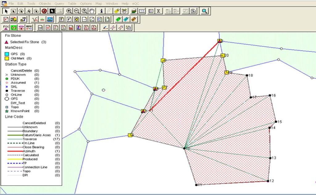
31 THE ADJUSTMENT : NDCDB CCDB FORMATION OF CADASTRAL NETWORK Data Integrity Check Connection Line File Data Selection Adjustment RE-COORDINATION USING AN AUTOMATED DATA CONVERSION SYSTEM (ADCS) DCDB Transformation Quality Control Temp NDCDB Editing SURVEY ACCURATE DIGITAL CADASTRAL DATABASE (NDCDB) NDCDB 31

32 NDCDB CADASTRAL CONTROL INFRASTRUCTURE (CCI) EMPLOYING WHOLE TO THE PART CONCEPT AND GPS TECHNOLOGY Primary Grid Secondary Grid 32

33 NDCDB State of Johor CCI Point 33
34 Methodology For Cadastral Data Migration To The New Geocentric Datum For Malaysia (GDM2000) Expected NDCDB Spatial Accuracy GDM2000 Establishment of Cadastral Control Infrastructure (CCI) Using JUPEM MyRTKnet GPS Service CATEGORY Urban/ New Development Std Dev Northing ± 5 cm or better Std Dev Easting ± 5 cm or better Cadastral Control Spacing 0.5 km Tie-Up of Selected Parcel Corners to CCI Automated Network Adjustment & Re-Coordination System Semi Urban/Rural ± 10 cm or better ± 10 cm or better 2.5 km Re-coordination and Re-population (R&R) Total estimated number of boundary marks to be recoordinated is about 40 million boundary marks. NDCDB 34


35 Background of NDCDB Multipurpose cadastre underpin a good Land Information System (LIS) Consequences: Hinder Integration of Spatial Data At National Level 35
36 NDCDB LS 600 Parties JUPEM 300 Parties JUPEM2U SUM eqc espek NDCDB District Surveyors CSRS 36
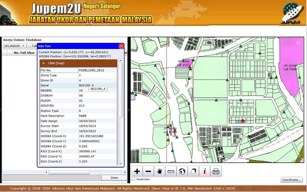
37 JUPEM2U (Cadastral Working Portal) 37
38 JUPEM2U JUPEM2U is the remote one-stop interface via the internet for designated users to conduct their business with States JUPEM without being physically present at states JUPEM offices; JUPEM2U application is to developed using Web technologies incorporating MapInfo GIS engines and MapXtreme. 38

39 JUPEM2U 39

40 JUPEM2U 40

41 JUPEM2U 41
42 JUPEM2U Databases, Files Servers CSRS Application Systems Gateway District Surveyors Application Modules Data Communications Data Exchange System Integrations Networking Application, Processing Servers, Workstations FIREWALL JUPEM2U SERVER Web server/komm server/sum Field Officers Licensed Land Surveyors (LLS) LLS Field Officers 42
43 CSRS, efee, ecadasonline (Cadastral Survey Record System, Survey Fee Module) 43
44 CSRS, efee, ecadasonline CSRS is a survey file management system; efee to calculate the actual survey fee after the Certified Plan is drawn and the job is completed; ecadasonline provide search and view of all survey information within the databases; Application developed using Web technologies incorporating MapInfo GIS engines and MapXtreme. 44
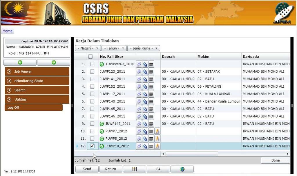
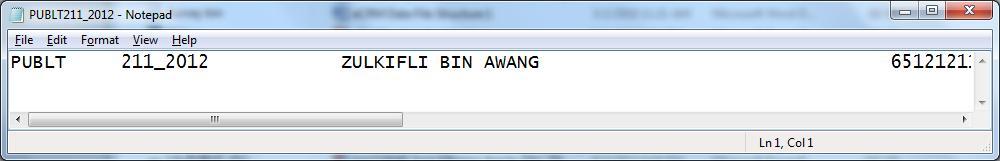
45 CSRS 45

46 efee SURVEY FEE REPORT : 46
47 ecadasonline 47
48 epu (Request of Survey (RS) File Registration and Field Tracing (eskl) issuing) 48
49 epu epu for survey file registration and produce of field tracing; Application developed incorporating with MapInfo GIS engines. 49
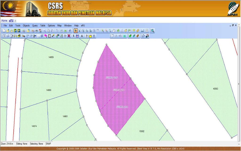
50 epu 50
 *.")
 1 2 PU Registration CSRS")


 *.")
51 Land Offices epu epu Section 3 PU Hardcopy PU Softcopy (PU ASCII) *.pub (boundary) *.pud (detail) *.pul (lot) 1 2 PU Registration CSRS Creating File Key-in PU Info generate lot number Scan, Digitise, Update PU layer (PU ASCII) 5 4 Generate SKL layer- SKL ASCII Pre_survey_layer Store physical File JUPEM2U Field Surveyors CRM Section SKL ASCII *.skl (Lot) *.skb (Boundary) *.job (Details) CRM Layer 51

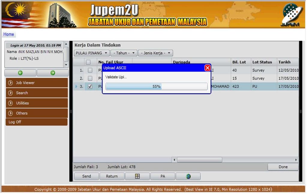
52 epu-file Structure 52

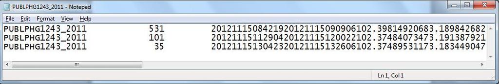
53 epu-scanned Document 53

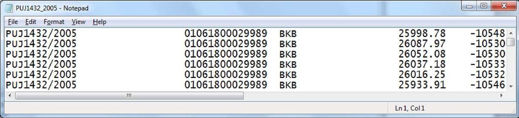
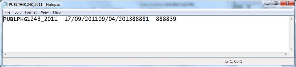
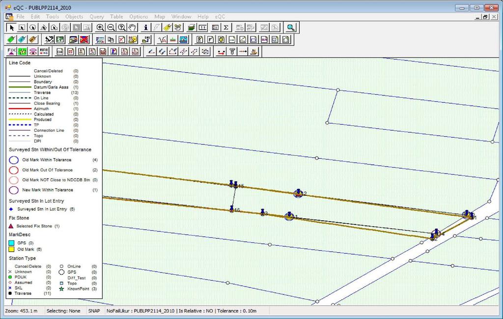
54 epu-skl ASCII Sample 54
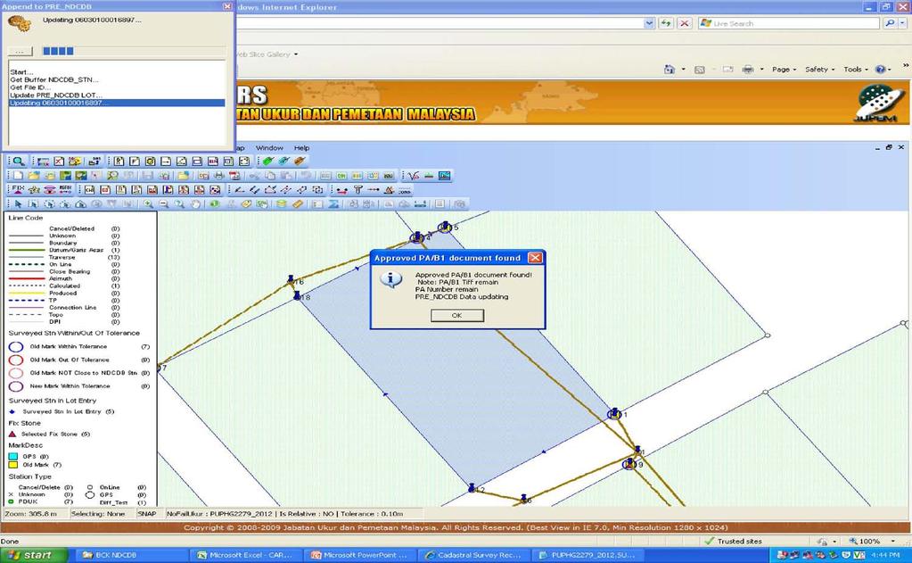
55 ecrm (Cadastral Reference Mark) 55
56 ecrm ecrm is a module with the aim of creating CRM points within the eglms layer database; Four (4) phases of processes in ecrm namely: Extraction, Establishment, Validation and Update; Application developed incorporating with MapInfo GIS engines. 56


57 ecrm RTK net 1 GEOPORTAL 2 ecrm Extract PU/QT & CRM Layer Internet JUPEM2U - Planning - Establish CRM - Observation - Processing - Transform Module 3 CRM Layer Update CRM/CCI LAYER DATABASE 57
58 ecrm 58

59 ecrm-file Structure 59

60 ecrm-file Structure 60
61 ecrm-sample ASCII 61
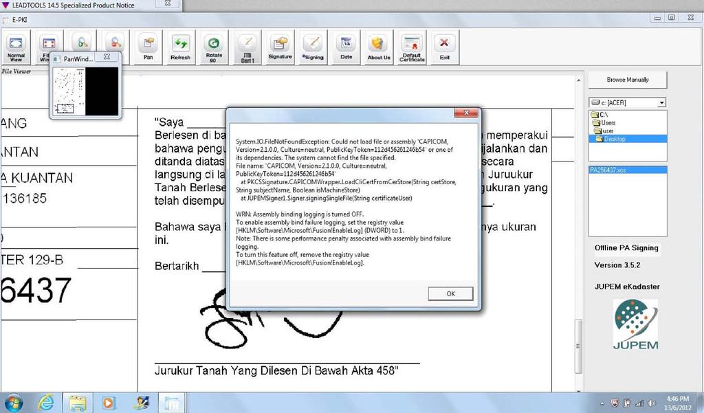
62 etsm (Title Survey Module Field Data Capturing) 62
63 etsm etsm is a module for field data capturing that comply with JUPEM Survey Regulation and practices; Application developed incorporating with MapInfo GIS engines. 63
64 etsm 64
65 etsm 65
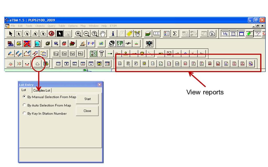
66 etsm 66

67 etsm-file Structure 67
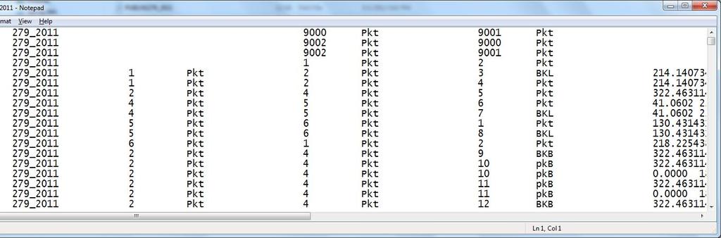
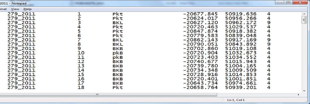
68 etsm-sample ASCII 68
69 69
70 esum, eqc, espek (Virtual Survey Module, Validation and Updating Module) 70
71 esum esum is a web-based application catered for the need to verify and validate the survey ASCII files submitted by JUPEM District Officer and Surveyors as well as from Licensed Land Surveyors, using Least Square Adjustment software; eqc is a module to validate surveyed data; espek using GIS engine to perform graphical computations, spatial analysis and NDCDB Updating; Application developed incorporating with MapInfo GIS engines. 71


72 esum Sistem Ukur Maya (SUM) is a web-based application allowing field officers to perform validation of survey data while in the field. The online adjustment is carried out using Least Square Software. 72
73 esum 73
74 eqc 74
75 espek 75
76 DRP (Digital Raster Plan Module) 76
77 DRP DRP is to cater to the need to handle the viewing, rasterization and production of ekadaster output products. These end products include Certified Plans (Title Survey & Strata/Stratum/Marin Survey), Gazette Plans, Title Plans (B1 & B4) as well as Standard Sheet. Application developed incorporating with MapInfo GIS engines. 77
78 DRP 78
79 A3 Landscape 79
80 DRP 80
81 81
82 epki (Public Key Infrastructure ) 82
83 epki PKI authentication solutions comply to Malaysia s Digital Signature Act (DSA) 1997 and the Digital Signature Regulation (DSR) 1998; Cater for digital authentication, digital signing and 2D bar coding with digital envelope; A complete PKI authentication solution from Malaysia s Certification Authority (CA). 83
84 epki 84
85 epki 85
86 PDUSSM, essm (Strata Survey Database and Strata Survey Module) 86
87 PDUSSM, essm To establish a digital strata database called Pangkalan Data Ukur Strata/Stratum/Marin (PDUSSM) with 2D and 3D graphical information, as well as the necessary tools to capture and manage the strata title plans digitally; Strata Survey Module (essm) to allow surveyors conduct verification survey for Strata parcels; Application developed incorporating with MapInfo GIS engines. 87

88 PDUSSM, essm 88

89 PDUSSM, essm 89

90 PDUSSM, essm 90
91 eglms (GIS Layer Management System) 91
92 eglms To enhance the current GLMS layers and expanded to cater to the ecadastre implementation, particularly with the establishment of NDCDB; An enhanced process of updating and maintenance of these layers are performed; Application developed incorporating with MapInfo GIS engines. 92
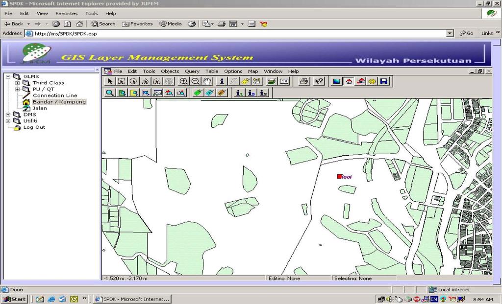
93 eglms 93
94 esupport (Fault Log Management System) 94
95 esupporty Enhance the present Fault Log Management System (FLMS) with additional functionalities; Establish a paperless management and monitoring system; Application developed incorporating with.net engines. 95

96 esupporty 96

97 esupporty 97
98 T H A N K YO U 98
CADASTRE SURVEY PRACTICE (SGHU 4323)
") CADASTRE SURVEY PRACTICE (SGHU 4323) WEEK 11-eCADASTRE SR DR. TAN LIAT CHOON 07-5530844 016-4975551 1 OUTLINE Coordinated Cadastral System National Digital Cadastral Database Multipurpose Cadastre 3D Cadastre
CADASTRE SURVEY PRACTICE (SGHU 4323) WEEK 11-eCADASTRE SR DR. TAN LIAT CHOON 07-5530844 016-4975551 1 OUTLINE Coordinated Cadastral System National Digital Cadastral Database Multipurpose Cadastre 3D Cadastre
PRESENTATION SUMMARY
 COORDINATED CADASTRAL SYSTEM FOR PENINSULAR MALAYSIA: FROM CONCEPT TO REALITY by: Professor Dr. Abd. Majid A. Kadir Associate Professor Ghazali Desa PMP Dr. Abdullah Hisam Omar Faculty of Geoinformation
Developing Infrastructure Framework To Facilitate The Malaysia Multipurpose 3D Cadastre
 Developing Infrastructure Framework To Facilitate The Malaysia Multipurpose 3D Cadastre Sr Dr. Tan Liat Choon Sr Looi Kam Seng University of Technology Malaysia Department of Survey and mapping Malaysia
METHODOLOGY FOR THE DEVELOPMENT OF NATIONAL DIGITAL CADASTRAL DATABASE (NDCDB)
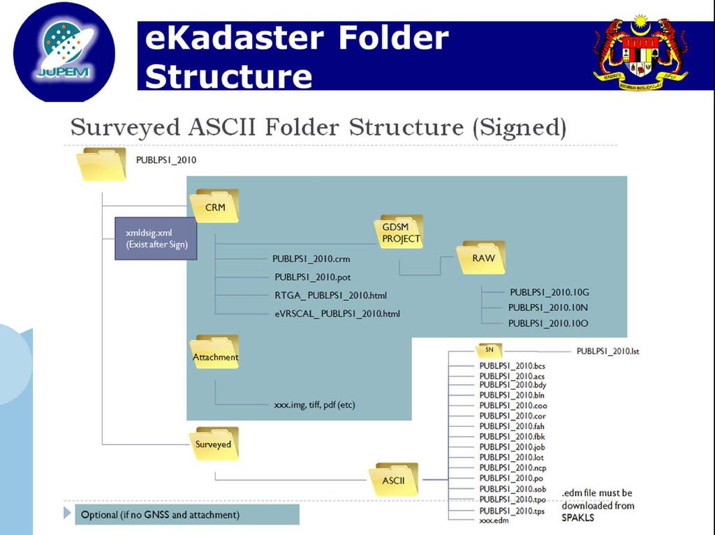
") KURSUS COORDINATED CADASTRAL SYSTEM (CCS) INSTITUT TANAH & UKUR NEGARA BEHRANG, PERAK METHODOLOGY FOR THE DEVELOPMENT OF NATIONAL DIGITAL CADASTRAL DATABASE (NDCDB) OLEH: PROF DR ABD MAJID BIN A KADIR
KURSUS COORDINATED CADASTRAL SYSTEM (CCS) INSTITUT TANAH & UKUR NEGARA BEHRANG, PERAK METHODOLOGY FOR THE DEVELOPMENT OF NATIONAL DIGITAL CADASTRAL DATABASE (NDCDB) OLEH: PROF DR ABD MAJID BIN A KADIR
SCOPE OF PRESENTATION
 INTERNATIONAL SYMPOSIUM AND EXHIBITION ON GEOINFORMATION Global Trends: Geoinformation For The New Economy Studies Toward the Development of Implementation Plan Of Coordinated Cadastral System for Peninsular
EKADASTER: A LEARNING EXPERIENCE FOR MALAYSIA
 EKADASTER: A LEARNING EXPERIENCE FOR MALAYSIA Mohd Yunus MOHD YUSOFF, Hasan JAMIL, Nur Zurairah ABDUL HALIM, Nor Ashikin MOHAMED YUSOF and Mohammad Azmi MOHD ZAIN, Malaysia Keywords: ekadaster, Cadastral
CURRENT TREND IN GEOINFORMATION TECHNOLOGY INTRODUCTION
 CURRENT TREND IN GEOINFORMATION TECHNOLOGY STUDIES TOWARD THE DEVELOPMENT OF IMPLEMENTATION PLAN OF COORDINATED CADASTRAL SYSTEM FOR MALAYSIA Abd. Majid A. Kadir, Shahrum Ses, Ghazali Desa, Kamalludin
Directorate of Survey and Mapping NAMIBIA. Cadastral Information System. Vehupisa Kasuko Tjatindi Surveyor Directorate of Survey and Mapping NAMIBIA
 Vehupisa Kasuko Tjatindi Directorate of Survey and Mapping NAMIBIA Tel: +64 61 965000 Directorate of Survey and Mapping NAMIBIA Cadastral Information System Introduction Over the past few decades cadastral
Egyptian Nationwide Title Cadastre System
 Kholoud SAAD, Egypt Key words: Cadastre, Registration, Urban, Rural, National Cadastre, Automation, reengineering. SUMMARY With growing need for integrated information, Enterprise Solutions has become
CADASTRAL STUDIES (MGU1014 / MGHU1514)
") CADASTRAL STUDIES (MGU1014 / MGHU1514) WEEK 8-LAW AND REGULATIONS (FIELD) SR DR. TAN LIAT CHOON 07-5530844 016-4975551 1 OUTLINE Field Survey Practice 2 FIELD SURVEY PRACTICE 3 Survey Datum For new survey
CADASTRAL STUDIES (MGU1014 / MGHU1514) WEEK 8-LAW AND REGULATIONS (FIELD) SR DR. TAN LIAT CHOON 07-5530844 016-4975551 1 OUTLINE Field Survey Practice 2 FIELD SURVEY PRACTICE 3 Survey Datum For new survey
Developing Infrastructure Framework to Facilitate the Malaysian Multipurpose 3D Cadastre
 Developing Infrastructure Framework to Facilitate the Malaysian Multipurpose 3D Cadastre TAN Liat Choon and LOOI Kam Seng, Malaysia Key words: land administration, land information, multipurpose 3D cadastre,
Cadastral services and virtual office in e-cadastre
 Cadastral services and virtual office in e-cadastre Priit Kuus Estonian Land Board October 26, 2016 Coimbra Scope of data Cadastral parcels (as of September 2016) 674 383 cadastral parcels, i.e. 97,7 %
INDIAN INSTITUTE OF TECHNOLOGY ROORKEE. Presentation on REAL TIME CADASTRAL SURVEYING SOLUTION WITH A SPECIAL IMPHESIS TO MODERN GPS TECHNOLOGY.
 INDIAN INSTITUTE OF TECHNOLOGY ROORKEE Presentation on REAL TIME CADASTRAL SURVEYING SOLUTION WITH A SPECIAL IMPHESIS TO MODERN GPS TECHNOLOGY By: Prof. Kamal Jain, Dept. of Civil Engg. IIT-Roorkee AIM
The New Technology of a Survey Data Model and Cadastral Fabric as the Foundation for a Future Land Administration System.
 The New Technology of a Survey Data Model and Cadastral Fabric as the Foundation for a Future Land Ian HARPER, Australia Key words: cadastral modelling, survey data model, Survey Accuracy, Cadastre 2014
CLICK HERE TO KNOW MORE
 CLICK HERE TO KNOW MORE LANDS AND SURVEYS DEPARTMENT SABAH, MALAYSIA GEO-CADASTRE IN LAND ADMINISTRATION: SABAH S EXPERIENCE Sr Hj SAFAR B UNTONG, FISM, MRICS Director, Lands & Surveys Department Sabah,
OUTLINE. Office Practice
 OUTLINE Office Practice 1 OFFICE PRACTICE 2 Deposited Plan Section 410 of the National Land Code 1965 provides the deposited plan that is a plan of the land shall be deposited if it is certified by the
City of Surrey s Digital Plan Submission Process
 City of Surrey s Digital Plan Submission Process Cadastral Update Karen Stewart, B.Tech. (GIS) Spatial Information Manager Peter Mueller, B.C.L.S., C.L.S. Survey Manager City of Surrey, British Columbia,
Land Administration and Spatial Enablement Victoria s Experience. Chris McRae, Executive Director Land Victoria
 Land Administration and Spatial Enablement Victoria s Experience Chris McRae, Executive Director Land Victoria 4 th UN Land Administration Forum, October 2011 Outline About Land Victoria Land Victoria
An Overview of the eplan Journey with a Focus on the Victorian eplan 2025 Roadmap Dr Hamed Olfat
 An Overview of the eplan Journey with a Focus on the n eplan 2025 Roadmap Dr Hamed Olfat eplan Coordinator Land Use Chairman of Technical Committee ICSM eplan Working Group Outline eplan Overview ICSM
Field surveying inspection using tablets
 Field surveying inspection using tablets Rami Farraj, Ahmad Sghyyer Survey of Israel, Lincoln 1, Tel-Aviv, Israel rami@mapi.gov.il ahmad@mapi.gov.il Key words: Field Surveying, Cadastre, Mapping Procedures
Engr. Juan P. Fernandez, Jr. Chief, Surveys and Mapping Division DENR Region-3 Club Royale Hotel, Malolos, Bulacan February 27,2016
 Engr. Juan P. Fernandez, Jr. Chief, Surveys and Mapping Division DENR Region-3 Club Royale Hotel, Malolos, Bulacan February 27,2016 ! DAO 2007-29 issued on July 31, 2007 re Revised Regulations on Land
BULGARIAN CADASTRE A GUARANTEE FOR THE OWNERSHIP RIGHTS IN IMMOVABLE PROPERTIES
 4 TH INTERNATIONAL CONFERENCE RECENT PROBLEMS IN GEODESY AND RELATED FIELDS WITH INTERNATIONAL IMPORTANCE February 28 - March 2, 2007, Inter Expo Centre, Sofia, Bulgaria BULGARIAN CADASTRE A GUARANTEE
Estonian e-cadastre as basis for efficient land management
 Estonian e-cadastre as basis for efficient land management Priit Kuus Estonian Land Board November 14, 2017 Tallinn Scope of data Cadastral parcels (as of October 2017) 693 026 cadastral parcels, i.e.
LRIMS Cadastre Module
 LRIMS Cadastre Module User Requirements and Functionality (Seychelles Case Study) John Latham, NRL Renato Cumani, NRL Luigi Simeone, NRL Summary Background User Requirements Business Model Application
In Conversation with Charles Young Bringing Government Cadastres Online
 In Conversation with Charles Young Bringing Government Cadastres Online Spatial Dimension Background Founded in 1999 with 4 staff Currently 50 staff (business analysts, programmers, database specialists,
International funding projects in Republic Geodetic Authority
 International funding projects in Republic Geodetic Authority Serbia: Republic Geodetic Authority Workshop Exploring Funding Instruments for NMCA 7-8 November 2012 Republic Geodetic Authority Republic
A Geocoded Cadastral Fabric as a Precondition for a Sustainable Land Management System
 A Geocoded Fabric as a Precondition for a Sustainable Land Management System Gottfried KONECNY, Germany; J.P. LAUZON, Canada; Abdul Salam MOHAMMED, India Key words: SDI,, Parcel Boundaries, GPS-GNSS, Land
Functional system for cadastral plans
 , Republic of Macedonia Key words: Cadastre, Digital plans, Data, System SUMMARY The analysis shows that the real estate market in Republic of Macedonia grows daily. With the expansion of this market increases
The Survey Data Model Technology A practical survey solution to generate all levels of spatial and e-governance outcomes.
 Land Governance in a Rapidly Changing Environment Annual World Bank Conference on Land and Poverty April 24 & 25, 2012 The Survey Data Model Technology A practical survey solution to generate all levels
SECTOR PUBLIC CADASTRES AND REGISTERS MARKET PARTICIPANTS
 E-SERVICES TO CITIZENS, GOVERNMENT AND BUSINESSES. LITHUANIA EXPERIENCE Arvydas Bagdonavičius State Enterprise Centre of Registers Arvydas.Bagdonavicius@registrucentras.lt REGISTERS AND IS MANAGED BY THE
Demonstrate knowledge of, and extract, cadastral data from Landonline
 Page 1 of 5 Demonstrate knowledge of, and extract, cadastral data from Landonline Level 3 Credits 5 Purpose This unit standard is for people who are working in the surveying industry in jobs which involve
Meeting the Changing National Geospatial Information Needs. Palitha Udayakantha Surveyor General - Sri Lanka
 Meeting the Changing National Geospatial Information Needs Palitha Udayakantha Surveyor General - Sri Lanka Sri Lanka Location Latitude 5 55 10-9 50 6 North Longitude 79 31 19-81 52 36 East Area 65610
TOWARDS E-LAND ADMINISTRATION - ELECTRONIC PLANS OF SUBDIVISIONS IN VICTORIA
 TOWARDS E-LAND ADMINISTRATION - ELECTRONIC PLANS OF SUBDIVISIONS IN VICTORIA Mohsen Kalantari 1, Chris Lester 2, David R Boyle 3, Neil Coupar 4 1 eplan Coordinator 2 SPEAR Manager 3 Deputy Surveyor General
NEW DEVELOPMENTS IN THE REAL PROPERTY REGISTER AND CADASTRE IN LITHUANIA
 NEW DEVELOPMENTS IN THE REAL PROPERTY REGISTER AND CADASTRE IN LITHUANIA Jaunius Grigas E-mail: jaunius.grigas@registrucentras.lt Verona, 2008 FUNCTIONS OF STATE ENTERPRISE CENTRE OF REGISTERS Registration
ParcelMap BC Compiling a Parcel Fabric for the Province of British Columbia. Presented by: Ellen Styner (General Manager) and Wendy Amy (GIS Manager)
 and Wendy Amy (GIS Manager)") ParcelMap BC Compiling a Parcel Fabric for the Province of British Columbia Presented by: Ellen Styner (General Manager) and Wendy Amy (GIS Manager) Who is MNC? MNC is a geomatics engineering firm with
ParcelMap BC Compiling a Parcel Fabric for the Province of British Columbia Presented by: Ellen Styner (General Manager) and Wendy Amy (GIS Manager) Who is MNC? MNC is a geomatics engineering firm with
ParcelMap BC. Compiling a Parcel Fabric for the Province of British Columbia. WENDY AMY and ELLEN STYNER
 ParcelMap BC Compiling a Parcel Fabric for the Province of British Columbia WENDY AMY and ELLEN STYNER Who is MNC? Established in 1997, MNC is a geomatics engineering firm located in Calgary, Alberta.
Amalia Velasco Carlos Alonso Luis Virgos Fernando Serrano
 Inspire services of the Spanish Directorate General for Cadastre and its use to resolve an old problem of coordination between Spanish Cadastre and Land Registry. Amalia Velasco Carlos Alonso Luis Virgos
A Complete, Free Solution for Cadastral Map Management
 A Complete, Free Solution for Cadastral Map Management Gyula IVÁN Institute of Geodesy, Cartography & Remote Sensing (FÖMI) HUNGARY FIG Commission 7, Annual Meeting 11-15 September 2008., Verona, ITALY
Land Information System as new instrument for Land Administration: Case Examples. Mike Cheremshynskyi Consultant, Land Administration Expert
 Land Information System as new instrument for Land Administration: Case Examples Mike Cheremshynskyi Consultant, Land Administration Expert Background Growth of population and fast urbanization in many
A CADASTRAL GEODATA BASE FOR LAND ADMINISTRATION USING ARCGIS CADASTRAL FABRIC MODEL A CASE STUDY OF UWANI ENUGU, ENUGU STATE, NIGERIA
 A CADASTRAL GEODATA BASE FOR LAND ADMINISTRATION USING ARCGIS CADASTRAL FABRIC MODEL A CASE STUDY OF UWANI ENUGU, ENUGU STATE, NIGERIA BY Ndukwu, Raphael. Ike Department of Geoinformatics & Surveying University
GAUSSCAD A WEBGIS APPLICATION FOR COLLECTING CADASTRAL DATA
 M.M. Moise GaussCAD a WebGIS Application for Collecting Cadastral Data GAUSSCAD A WEBGIS APPLICATION FOR COLLECTING CADASTRAL DATA Mihai-Mircea MOISE, S.C. GAUSS S.R.L., mihai.moise@gauss.ro Abstract:
Key Registers in Finland and some views of Cadastre 2035
 Presented at the FIG Working Week 2016, May 2-6, 2016 in Christchurch, New Zealand Key Registers in Finland and some views of Cadastre 2035 FIG Working Week, Christchurch New Zealand May, the 3rd, 2016
ArcCadastre Implementations within the Middle East
 ArcCadastre Implementations within the Middle East Kholoud Saad SALAMA, Egypt Key words: Cadastre, GIS, Survey, Data Conversion, Workflow SUMMARY In recent years, cadastre systems have developed from manual
COUNTRY REPORT ON CADASTRE AND LAND REGISTRAION IN IRAN. By: Hamid Berenjkar, IRAN
 COUNTRY REPORT ON CADASTRE AND LAND REGISTRAION IN IRAN By: Hamid Berenjkar, IRAN Key words: Comprehensive Cadastre, Cadastre System, Cadastral Survey, Land Book, Iran ABSTRACT Land registration and cadastral
DATR towards e-land Administration in Hungary
 DATR towards e-land Administration in Hungary Gyula IVÁN-Gábor SZABÓ-Zoltán WENINGER-Piroska Zalaba Institute of Geodesy, Cartography and Remote Sensing, Budapest, HUNGARY XXIV. FIG Congress Facing the
The Development of the Austrian Cadastre from Documentation to an Integrated Planning and Decision Support System
 The Development of the Austrian Cadastre from Documentation to an Integrated Planning and Decision Support System WPLA - Working Party on Land Administration 15-17 October 2014, Vienna, Austria Wernher
Massive Collection of Cadastral Data in Greece Using Web-enabled GIS Technologies
 Massive Collection of Cadastral Data in Greece Using Web-enabled GIS Technologies Lefteris LYKOUROPOULOS and George MOURAFETIS, Greece Key words: Cadastre, Web services, applications, GIS, data collection
The Integration of CORS Networks and the Cadastre and its Application in NSW, Australia
 The Integration of CORS Networks and the Cadastre and its Application in NSW, Australia Jai REDDY, Australia Key words: digital cadastre, CORS, GNSS, cadastral system SUMMARY In many countries, CORS networks
The creation of a Survey Accurate Cadastral Map for surveyed areas in Trinidad & Tobago
 The creation of a Survey Accurate Cadastral Map for surveyed areas in Trinidad & Tobago Anesh Gopee, Keith Miller and Charisse Griffith Charles University of the West Indies Trinidad aneshtt@yahoo.com
The Cadastral Modelling Future and The Land Surveyors Role
 The Cadastral Modelling Future and The Land Surveyors Role Ian Harper Geodata Australia ESRI Survey Summit July 2013 The Land Surveyors Future Role From Custodians of the Cadastre to Custodians of the
Establishing a Land policy reform and GPS Technology implementation in Burkina Faso
 Annual World Bank Conference on Land and Poverty 2013 Establishing a Land policy reform and GPS Technology implementation in Burkina Faso Presentation made by Moha EL-AYACHI, IAV Hassan 2, Morocco Paper
REFORM OF LAND CADASTRE IN LITHUANIA
 REFORM OF LAND CADASTRE IN LITHUANIA Romualdas KASPERAVICIUS, Lithuania Key words: ABSTRACT Main aim for every Government is to create legal, financial and organisational circumstances for real property.
Ⅱ-2. The Resurvey Project
 Presenter : JANG, Bong-Bae MLTM Ministry of land,transport and Maritime Affairs KIM, Soon-Tae KCSC Korea Cadastral Survey Corp., JANG, Bong-Bae Ⅰ. INTRODUCTION The Korean modern cadastral system was established
The Journey to 100% Electronic Survey. Land Information New Zealand. August 2009
 The Journey to 100% Electronic Survey and Title Lodgement Land Information New Zealand August 2009 Land Information New Zealand Established 1996 Titles, Survey, Geodetic, Electoral 12 locations 500 staff
AREC responsibilities, data and registries and the way of their distribution
 Data as a basis of the digital society PCC, 13-15 March 2018, Sofia AREC responsibilities, data and registries and the way of their distribution Vlatko Dimovski Agency for Real Estate Cadastre (AREC) the
Country report, HUNGARY
 Country report, HUNGARY Gyula IVÁN Institute of Geodesy, Cartography & Remote Sensing (FÖMI) HUNGARY FIG Commission 7 Annual Meeting 2009 12-16 October, 2009, Kuala Lumpur, Malaysia Institute of Geodesy,
PROJECT INFORMATION DOCUMENT (PID) CONCEPT STAGE Report No.: AB3229 Project Name. Land Registry and Cadastre Modernization Project Region
 CONCEPT STAGE Report No.: AB3229 Project Name. Land Registry and Cadastre Modernization Project Region") PROJECT INFORMATION DOCUMENT (PID) CONCEPT STAGE Report No.: AB3229 Project Name Land Registry and Cadastre Modernization Project Region EUROPE AND CENTRAL ASIA Sector Central government administration
PROJECT INFORMATION DOCUMENT (PID) CONCEPT STAGE Report No.: AB3229 Project Name Land Registry and Cadastre Modernization Project Region EUROPE AND CENTRAL ASIA Sector Central government administration
A Vision for a Fully Digital Cadastral Survey System
 A Vision for a Fully Digital Cadastral Survey System Anselm HAANEN, Trent GULLIVER, New Zealand Key words: cadastral survey system, digital cadastre, survey plans SUMMARY Surveyors have traditionally prepared
LIS a motivation for SDI initiative
 Eric Mwaikambo Ardhi University Dar es Salaam Tanzania Overview Status of LIS in Tanzania Relationship between SDI and LIS Spatial Standards LIS a motivation for SDI initiative Conclusion & Recommendations
The Digital Cadastral Database and the Role of the Private Licensed Surveyors in Denmark
 IRISH INSTITUTE OF SURVEYORS, DUBLIN INSTITUTE OF TECHNOLOGY, 23 NOVEMBER 2005 PUBLISHED IN IIS NEWS, WINTHER 2006. The Digital Cadastral Database and the Role of the Private Licensed Surveyors in Denmark
DIGITAL CADASTRAL DATABASES : THE AUSTRALIAN EXPERIENCE
 Proceedings of AGI 97 Conference, Birmingham, UK DIGITAL CADASTRAL DATABASES : THE AUSTRALIAN EXPERIENCE Wolfgang Effenberg Division of information Technology La Trobe University Email: w.effenberg@bendigo.latrobe.edu.au
Cloud GIS Real Estate Management, Appraisal and Development Service USING ESRIs ARCGIS SERVER
 Cloud GIS Real Estate Management, Appraisal and Development Service USING ESRIs ARCGIS SERVER INFODIM: Was founded on 1992 and is internationally certified as a GIS company from D&B Dun & Bradstreet Global
Cadastral Information System of Sofia
 Alexander LAZAROV and Hristo DECHEV, Bulgaria Key words: ABSTRACT A new Cadastre and Property Register Act (CPRA) was passed in April 2000, setting up rules for the maintenance of these two registers.
New Models for Property Data Verification and Valuation
 New Models for Property Data Verification and Valuation for 2006 IAAO Councils and Sections Joint Seminar May 9-11, 2006 Charleston, South Carolina Presented by George Donatello, CMS Principal Consultant
PREPARING SURVEY TENDER GIS DATABASE OUTCOMES
 PREPARING SURVEY TENDER SPECIFICATIONS FOR PROJECT GIS DATABASE OUTCOMES Presentation by Ian Harper GEODATA AUSTRALIA ESRI User Conference 2009 24 st July 2009 BACKGROUND GIS databases now provide a more
Shaping the Cadastral Infrastructure for a Digital Future
 DEPARTMENT OF LANDS PLANNING and the ENVIRONMENT Shaping the Cadastral Infrastructure for a Digital Future Craig Sandy Director Surveys Surveyor General Survey Branch NT Australia Digital Cadastral Databases
Cadastral data services in Estonia
 Cadastral data services in Estonia Mr. Priit Kuus Department of Land Cadastre priit.kuus@maaamet.ee +372 675 0843 Ventspils 2013 Cadastre today Land Cadastre Act Adopted on 12 Oct.1994, since then amended
The Multipurpose Hungarian Unified Land Registry System
 The Multipurpose Hungarian Unified Land Registry System András Osskó FIG Working Week Integrating Generation Stockholm, Sweden 14-19 June 2008 Republic of Hungary is located in Central Europe Neighbouring
National Report. Submitted by Cyprus **
 UNITED NATIONS E/CONF.97/5/CRP. 12 ECONOMIC AND SOCIAL COUNCIL Seventeenth United Nations Regional Cartographic Conference for Asia and the Pacific Bangkok, 18-22 September 2006 Item 6 (b) of the provisional
New Developments in the Hellenic Cadastre
 New Developments in the Hellenic Cadastre Prof. M. Kavouras Vice-president Ktimatologio S.A. (Hellenic Cadastre) The Hellenic Cadastre Background The Hellenic National Cadastre Organizational and institutional
Serbia Should Have Online Cadastre for Property Like Other Countries in the Region
 Serbia Should Have Online Cadastre for Property Like Other Countries in the Region Tamara Borovcanin USAID Business Enabling Project The online real estate registry allows citizens to quickly and easily
LIS Development Project and Measures Proposed to Enhance Trust in the Land Administration System in Uganda
 Project for Design, Supply, Installation and Implementation of the Land Information System and Securing of Land Records (DeSILISoR) LIS Development Project and Measures Proposed to Enhance Trust in the
Reporting Thailand Cadastral System in Cadastre 2014 Trends BY VUTTINAN UTESNAN. Rajamangala University of Technology Krungthep
 Reporting Thailand Cadastral System in Cadastre 2014 Trends BY VUTTINAN UTESNAN Rajamangala University of Technology Krungthep Faculty of Engineering, Bangkok, THAILAND Topics INTRODUCTION THAILAND CADASTRAL
QUESTIONNAIRE. 1. Authorizing statute(s) citation West Virginia Code and 11-1C-4(d)
 citation West Virginia Code and 11-1C-4(d)") QUESTIONNAIRE (Please include a copy of this form with each filing of your rule: Notice of Public Hearing or Comment Period; Proposed Rule, and if needed, Emergency and Modified Rule.) DATE: 6/8/15 TO:
QUESTIONNAIRE (Please include a copy of this form with each filing of your rule: Notice of Public Hearing or Comment Period; Proposed Rule, and if needed, Emergency and Modified Rule.) DATE: 6/8/15 TO:
Agenda Project Overview Project Objectives Registration Service Re-Engineering System Overview
 Agenda Project Overview Project Objectives Registration Service Re-Engineering System Overview Sydney, Australia, 11 16 April 2010 1 Project Overview Future Vision There is a vision within senior levels
Development of the New Cadastral Survey System in Tanzania
 Samwel S. KATAMBI, Tanzania Keywords: Cadastral Survey System, Cadastre, Land Administration, NSDI. SUMMARY In recent years the demand for cadastral survey informations in Tanzania has been increasing
The Land Information System
 Country report News from the Cadastre in Finland Ari Tella 24.10.2016 FIG Commission 7 Annual Meeting, Coimbra Portugal The Land Information System NLS 2010 Land 2013 Maintenance Information Service Customers
Towards the Introduction of Workflow Management at the Netherlands Cadastre. WFM at NL Cadastre. Basic datamodel. Den Bosch G 7625
 Towards the Introduction of Workflow Management at the Netherlands Cadastre Berry van Osch Christiaan Lemmen Wednesday, May 26 2004 FIG Working Week Athens WFM at NL Cadastre Basic datamodel Nothing really
Presented by: Stewart Information International, Inc. Jack McKenna
 Presented by: Stewart Information International, Inc. Jack McKenna Held at the: 2007 ESRI Survey & Engineering GIS Summit San Diego Convention Center San Diego, California June 16-19, 2007 Integrating
CADASTRAL WORKS in TURKEY AND GDLRC (TKGM)
") CADASTRAL WORKS in TURKEY AND GDLRC (TKGM) NOVEMBER 2011 SOME NUMBERS ABOUT TURKEY Area :783.600 Km 2 Population : 747 millions (2008) Number of land parcels : 555 millions Villages and quarters : 52.437
CADASTRAL WORKS in TURKEY AND GDLRC (TKGM) NOVEMBER 2011 SOME NUMBERS ABOUT TURKEY Area :783.600 Km 2 Population : 747 millions (2008) Number of land parcels : 555 millions Villages and quarters : 52.437
Quality Improvement to Cadastral Information in Sweden
 Gunnar BLIXT, Sweden Key words: digital cadastre, quality, cadastral index map, real property register. SUMMARY Lantmäteriet is a governmental agency which gives support for creating an efficient and sustainable
New Technology for Cadastral Systems. Brent Jones, PE, PLS
 New Technology for Cadastral Systems Brent Jones, PE, PLS Benefits of Good Land Administration Key to addressing global challenges.. Secure Tenure Equitable Land and Property Taxation Support for Government
Property Based Land Information Systems of Turkey
 Property Based Land Information Systems of Turkey Mehmet Fatih DİRİ, Bilgehan ÖZSOY, Ünsal ERGÜN, Turkey Key words: Cadaster, Land Registry, GIS, Property, TURKEY SUMMARY The property, addition to the
Technology-driven solutions for the innovation of land administration and management
 Technology-driven solutions for the innovation of land administration and management Technology and economic growth - Studies*find link between technology innovation and national economic prosperity especially,
Using ICT to drive Business Process Change within Land Registry Offices Symposium on Innovative Technology for Land Administration
 Peter Rabley, ILS Using ICT to drive Business Process Change within Land Registry Offices Symposium on Innovative Technology for Land Administration June 23-24, 2005 Madison, Wisconsin Presentation Overview
GLOBAL GEOSPATIAL MANAGEMENT INFORMATION
 GLOBAL GEOSPATIAL MANAGEMENT INFORMATION SEOUL, KOREA 24 th to 26 th October 2011 COUNTRY REPORT - REPUBLIC OF BOTSWANA 1. INTRODUCTION 1.1. SOCIAL, ECONOMIC AND POLITICAL BACKGROUND Botswana attained
Commission No : 5 RCBMS : OVERVIEW
 RFID-Based Cadastral Boundary Mark System (RCBMS Abdullah Hisam Omar Tajul Ariffin Musa Ivin Amri Musliman Siti Syukriah Khamdan Kamaludin Omar Universiti Teknologi Malaysia Email: abdullahhisham@utm.my
Problems and Solution Proposals in Integration of Cadastral Data into Geographical Information System (GIS) in Turkey
 in Turkey") Problems and Solution Proposals in Integration of Cadastral Data into Geographical Information System (GIS) in Turkey Gülgün OZKAN, S. Savas DURDURAN, Ali ERDI and Bilal GIRGIN, Turkey Key words: Cadastre,
Problems and Solution Proposals in Integration of Cadastral Data into Geographical Information System (GIS) in Turkey Gülgün OZKAN, S. Savas DURDURAN, Ali ERDI and Bilal GIRGIN, Turkey Key words: Cadastre,
Advances in Modern Land Administration Cadastre 2014 in the Year 2006
 Advances in Modern Land Administration Cadastre 2014 in the Year 2006 Winfried HAWERK, Germany Key words: E-Land Administration, IT renewal strategies SUMMARY FIG Commission 7 Working Group 7.3 deals with
Object Oriented Unified Real Estate Registry for a Good Spatial Data Management
 Object Oriented Unified Real Estate Registry for a Good Spatial Data Management Gyula IVÁN Gábor SZABÓ Zoltán WENINGER Institute of Geodesy, Cartography and Remote Sensing (FÖMI), Hungary Workshop on e-governance,
LAND ADMINISTRATION AND VALUATION INFORMATION SYSTEM (LAVIMS) FIVE YEARS OF OPERATIONS IN MAURITIUS
 FIVE YEARS OF OPERATIONS IN MAURITIUS") LAND ADMINISTRATION AND VALUATION INFORMATION SYSTEM (LAVIMS) FIVE YEARS OF OPERATIONS IN MAURITIUS GRAHAM DEANE, TIM PATTISON Airbus Defence and Space, United Kingdom NAVINCHANDRA LUCHOO Ministry of Housing
LAND ADMINISTRATION AND VALUATION INFORMATION SYSTEM (LAVIMS) FIVE YEARS OF OPERATIONS IN MAURITIUS GRAHAM DEANE, TIM PATTISON Airbus Defence and Space, United Kingdom NAVINCHANDRA LUCHOO Ministry of Housing
Will County GIS Product Distribution Policy January, 2008
 Will County GIS Product Distribution Policy January, 2008 Background: The goal of this policy is to provide GIS products to users in a reasonable manner and to ensure that products released are of sufficient
Generic land administration business. FAO Workshop Rome, November 18-19,
 Generic land administration business FAO Workshop Rome, ovember 18-19, 2010 18.11.2010 1 Objectives Agree about what is the core land administration business common to all countries Derive the corresponding
LAND REGISTRATION SYSTEM OF THE REPUBLIC OF CROATIA
 "On the last day of the Creation God desired to crown His work, and thus created Kornati Islands out of tears, stars and breath." (George Bernard Shaw) LAND REGISTRATION SYSTEM OF THE REPUBLIC OF CROATIA
State Department of Assessments and Taxation
 Audit Report State Department of Assessments and Taxation December 2013 OFFICE OF LEGISLATIVE AUDITS DEPARTMENT OF LEGISLATIVE SERVICES MARYLAND GENERAL ASSEMBLY This report and any related follow-up correspondence
Spatial Data Warehouse Ltd. Cadastral Mapping INITIATIVE 1: CADASTRAL MAPPING. Version Spatial Data Warehouse Ltd. & AltaLIS Ltd.
 Spatial Data Warehouse Ltd. Initiative 1: Cadastral Mapping INITIATIVE 1: CADASTRAL MAPPING 29 P3 The SDW/AltaLIS Model Background The Government of Alberta started a mapping program, the Municipal Integrated
Land Information System for Revenue Planning, Estimates and Collection
 Land Information System for Revenue Planning, Estimates and Collection Hardi FADILLAH HAMZAH, Malaysia Key words: valuation, land revenues SUMMARY With the emerging trend of State Government implementing
By: Barney I. S. Laseko Programme Coordinator Prime Minister s Office TANZANIA
 2014 CONFERENCE ON LAND POLICY IN AFRICA 11 14 NOVEMBER, 2014 Focussed Discussion VIII Converting from Manual Land Registration to GIS Enabled Land Information System Case of Sub Saharan Africa Tanzania
IT-SUPPORTED STATE-LAND MANAGEMENT IN A TRANSITIONAL ENVIRONMENT
 IT-SUPPORTED STATE-LAND MANAGEMENT IN A TRANSITIONAL ENVIRONMENT - Examples from Eastern Germany and Mongolia - TOPICS 1 S LAND INFORMATION SYSTEM History and main components IT-strategy and development
Map Modernization Modernization Program
 FEMA Map Modernization Program Presented to Maryland Association of Floodplain and Stormwater Managers October 27, 2005 Map Modernization Program Autorun.exe 2 Map Modernization Program Outline Map Mod