THE EXISTING LEGAL CADASTRE REGISTRATION OF CADASTRAL SPATIAL RIGHTS IN ISRAEL R&D PROJECT IN ISRAEL IN ISRAEL R&D PROJECT THE EXISTING LEGAL CADASTRE
|
|
|
- Cuthbert Weaver
- 5 years ago
- Views:
Transcription
, dividing all land registration into continuous blocks and parcels.")
1 THE EXISTING LEGAL CADASTRE Introduced in 1928 by the British mandatory government in than Palestine. REGISTRATION OF CADASTRAL SPATIAL RIGHTS Based on Torrens principles (Registration of Title), dividing all land registration into continuous blocks and parcels. Two-Dimensional (2D) and deals with property located on the surface only. The property right in a land parcel, extends from the center of the earth radially outwards into space, including all that is built or cultivated upon its surface. 2 R&D TEAM: URI SHOSHANI, MOSHE BENHAMU, ERI GOSHEN, SHAUL DENEKAMP and ROY BAR1 - BACKGROUND Fast economic development, population growth from 6 millions people up to 13 millions by 2050, increasing building density while preserving the remaining open spaces. The existing cadastral system, due to being 2D, is unsuitable for the multilayer reality that has evolved allready in recent years. Cabinet Decisions from 1999:... arrangement of conditions for exploitation of land parcel for several uses, above and below the surface, taking into account the status of the original owner of the land and the possibilities of a partial expropriation of its rights, providing geodetic, cadastre, planning, engineering and 4 legal solutions. THE EXISTING LEGAL CADASTRE Example of a part of a registration block : 3 - THE PRINCIPAL OBJECTIVES 1. A solution for the definition and registration of parcels in space. 2. Formulation of proposals for changes in the existing Land Law, the Planning and the Construction Law and the Survey Ordinance, considering the applicable engineering and planning constraints. 3. Accumulation of the altimetric data to be added to the 2D cadastre thus creating the 3D database. 4. Formulation of a solution for the management of the legal coordinated cadastre information, in 2D and 3D GIS environment. 5. The examination and development of suitable software for the visualization of 3D cadastre. 6. Formulation of a suitable modification of the Survey 6 Regulations in order to facilitate registration of 3D cadastre. - BACKGROUND The Survey of Israel initiated and specified in September 2002 a R&D project for the coming two years. The R&D project is carried out by 5 experts coming from several disciplines: Cadastre, Geodesy, GIS, Law, Planning and Construction, Geology and Soil Engineering. Two governmental commissions monitor the work of the R&D team. The first, monitors the research work. The second, examines the legal changes recommended by the R&D team and will represent them to the cabinet. The Ministry of Finance approved a budget of app. 1 million USD s for the R&D project and for preparing pilot projects. 5 1


2 Above-Terrain Space Sub-Parcel No. 1 Upon The Surface Sub-Parcel No. 2 in The Subterranean Space No. 3 in Sub-Parcel Parcel Space The Subterranean The Subterranean Space 8 The spatial registration will be achieved by sub-dividing the surface space into spatial sub-parcels. The definition of the surface parcel will remain unchanged. The Title Rights to the surface parcel will be preserved to the existing definition of the surface parcels as extending infinitely above and below the surface. The spatial sub-parcel will be defined as a final volume object. Any project established in above or bellow the surface, will be bounded and defined stereometricaly by a final 3D outline and its volume. 7 Allowing extension and adaptation of the existing registration system to the new spatial cadastral reality without infringement to the system itself. Necessary amendments will be made in the Land Law, Planning and Construction Law and the Survey Ordinance. The final registration of the subterranean sub-parcels will usually be made only after the project has been completed, measured as-made and registered accordingly. During the planning and construction stages only a warning note will be registered. 10 A spatial project, which extends above or bellow a number of surface parcels, will be thus subdivided into spatial sub- parcels, in accordance with the existing surface parcels. It will be possible to consolidate the spatial sub-parcels, within a registration block, into one spatial parcel. No infringement to the rights of property, except for proper purposes and limited to the minimal required extent. The stability of the existing structures built on the surface of the earth, will be achieved by setting off distances to them and to the spatial sub-parcel as well, imposed by engineering considerations. 9 'SUHVHQWDWLRQRIWKH VSDWLDOVXESDUFHOVRQ SDUFHOVRQ WKHEDFNJURXQGRf WKH H[LVWLQJODQGSDUFHOV 3ODQHSURMHFWLRQRIWKH VSDWLDOSDUFHORQWKH H[LVWLQJODQGSDUFHOV The future cadastre will be incorporated into the national GIS system and will be managed by GIS means. This will result in a more efficient planning, exploitation and management of all three spaces of the land. All maps and plans will be based on a digital database, as vectors, GIS and digital maps. The spatial activities will be shown three-dimensionally (perspective and sections) in a plane projection on the computers monitor


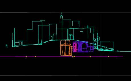
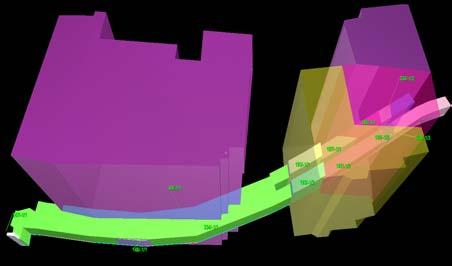
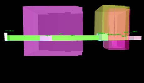
3 Description underground railway station Height Layer private company municipality of Modi in public garden private company central bus station municipality of Modi in bridge to bus station government of Israel public areas government of Israel and municipality of Modi in commercial and public buildings THE OLD TOWN OF ACRE 3D Presentation of The Roads A Vertical Cross-Section St. Andreas Church A 3D Model of The Town Center of Modi in Levels Ownership 15 A Plan for Spatial Registration Purposes Knight Halls (Crypt) The Templer s Tunnel

 THE")

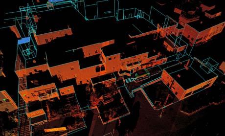
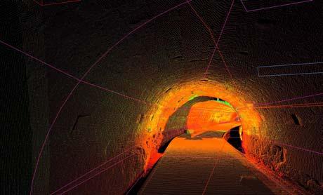
4 /DVHU6FDQQHU 6W$QGUHDV&KXUFK 6W$QGUHDV&KXUFK 7KH7HPSOHU V 7XQQHO 2) THE ST. ANDREAS CHURCH 6W$QGUHDV&KXUFK '0RGHO&RPSLODWLRQ 6W$QGUHDV&KXUFK *HQHUDO2XWORRN 2) THE ST. ANDREAS CHURCH 7KH7HPSOHU V 7XQQHO /DVHU6FDQQLQJ 6W$QGUHDV&KXUFK D9HUWLFDO&URVV6HFWLRQ 4

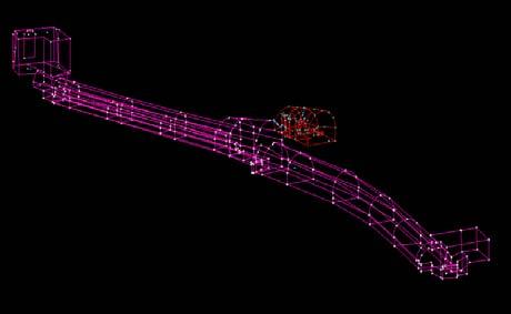
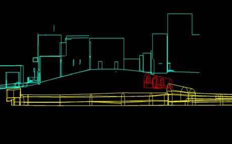
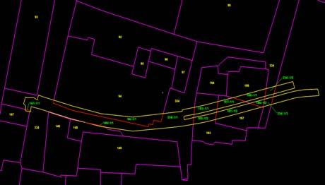
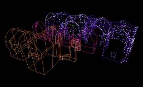
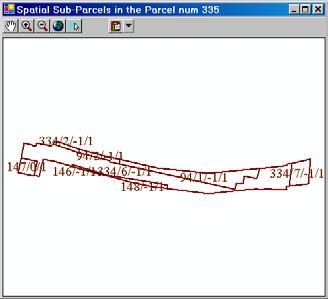
5 7KH7HPSOHU V 7XQQHO '0RGHO&RPSLODWLRQ 7KH7HPSOHU V 7XQQHO /DVHU6FDQQLQJ 7KH6SDWLDO6XE3DUFHO 3ODQH3URMHFWLRQ2Q7KH([LVWLQJ3DUFHOV 7HPSOHU V 7XQQHO D9HUWLFDO&URVV6HFWLRQ 29 5


6 COMPUTERISED PROTOTYPE FOR One of the tasks of the R&D project is the development of an active, computerized prototype of the Registration of Rights in space, in a GIS environment. The prototype of the GIS system is applied to the management of spatial cadastral database and will facilitate queries, visualization, production of reports and maps. The prototype will support testing and demonstration of the solution recommended by the R&D team. 3) A MULTISTORY BUILDING 0XOWLVWRU\%XLOGLQJ 7KH6XEWHUUDQHDQ3DUNLQJ 34 $'0RGHORI7KH%XLOGLQJ DQG7KH3DUNLQJ 7KH/DQG3DUFHOV 33 5HJDUGLQJWR7KH3DUNLQJ COMPUTERISED PROTOTYPE FOR 7KH2ULJLQDO6XUIDFH3DUFHOVLQ5HJDUGWR7KH6SDWLDO3DUFHO 6SDWLDO3DUFHO5HSRUW COMPUTERISED PROTOTYPE FOR 7KH7HPSOHU V 7XQQHO $'LVSOD\RI6SDWLDO$FWLYLW\:LWKLQD5HJLVWUDWLRQ%ORFN '0RGHO 6SDWLDO6XE3DUFHO UWKRSKRWR 6
7 REGISTRATION OF CADASTRAL SPATIAL RIGHTS SUMMARY A number of actions have been initiated in Israel in preparation for the 3D cadastre, including government decisions and finance of the R&D project. The R&D project is one of the first of its kind. The final results of the R&D project, due in August 2004, will hopefully lead to the realization of the 3D cadastre in Israel and will assist the authorities in the transition period. 38 R&D TEAM: URI SHOSHANI, MOSHE BENHAMU, ERI GOSHEN, SHAUL DENEKAMP and ROY BAR The R&D team has already formulated number of recommendations for the transition steps, some of them were described in the attached article. 37 7
A Multi Layers 3D Cadastre in Israel: A Research and Development Project Recommendations
 A Multi Layers 3D Cadastre in Israel: A Research and Development Project Recommendations Uri SHOSHANI, Moshe BENHAMU, Eri GOSHEN, Saul DENEKAMP and Roy BAR, Israel Key words: Spatial Sub-Parcel, Spatial
Registration of Cadastral spatial Rights in Israel A Research and Development Project
 Registration of Cadastral spatial Rights in Israel A Research and Development Project Uri SHOSHANI, Moshe BENHAMU, Eri GOSHEN, Saul DENEKAMP and Roy BAR, Israel Key words: spatial sub-parcel, spatial parcel,
An Interdisciplinary 3D Cadastre Development Project in Practice
 An Interdisciplinary 3D Cadastre Development Project in Practice Joseph FORRAI and Gili KIRSCHNER, Israel Key words: Cadastre, 3DCad, R&D, Survey of Israel SUMMARY In September 2002, a two year long R&D
ASPECTS OF A 3D CADASTRE IN THE NEW CITY OF MODI IN, ISRAEL
 ASPECTS OF A 3D CADASTRE IN THE NEW CITY OF MODI IN, ISRAEL ARMI GRINSTEIN Armi Grinstein - Geodetic Engineering Ltd. Israel ABSTRACT 3 Dimensional Cadastre is a relatively new sphere in property registration,
Implementation of the 3D Cadastre in Israel. Rachel ADI, Anna SHNAIDMAN and Shimon BARAZANI, Israel
 Implementation of the 3D Cadastre in Israel Rachel ADI, Anna SHNAIDMAN and Shimon BARAZANI, Israel Key words: Israel, 3D Cadaster, LADM, 3D Registration. SUMMARY Cadastre can be referred to as a legal
A Multilayer 3D Cadastre: Problems and Solutions
 Moshe BENHAMU and Prof. Yerach DOYTSHER, Israel Key words: geospatial object, multilayer cadastral reality, 3D cadastral data models, multispace property rights registration. ABSTRACT This paper presents
TRANSITION FROM TWO-DIMENSIONAL LEGAL AND CADASTRAL REALITY TO A THREE-DIMENSIONAL ONE
 TRANSITION FROM TWO-DIMENSIONAL LEGAL AND CADASTRAL REALITY TO A THREE-DIMENSIONAL ONE JOSEPH FORRAI AND GILI KIRSCHNER Survey of Israel Israel ABSTRACT The problem of the intensive use of land and the
Topographic Signs Important Context of 3D Cadastre
 STATE GEODETIC ADMINISTRATION Gruška 20,10 000 Zagreb, Croatia Delft University of Technology Faculty of Architecture and the Built Environment Department OTB GIS Technology Section Topographic Signs Important
REGISTRATION OF PROPERTIES IN STRATA
 REGISTRATION OF PROPERTIES IN STRATA REPORT ON THE WORKING SESSIONS INTRODUCTION A cadastre is usually, and in most countries, a parcel-based, and up-to-date land information system containing records
Quality Improvement of the Real Estate Cadastre in Serbia
 , Serbia Key words: quality improvement, real estate information, quality assurance, Serbia SUMMARY The concept of cadastral modernization in the Republic of Serbia was defined in 1992, and it is being
INTERNATIONAL JOURNAL OF GEOMATICS AND GEOSCIENCES Volume 2, No 2, 2011
 INTERNATIONAL JOURNAL OF GEOMATICS AND GEOSCIENCES Volume 2, No 2, 2011 Copyright 2010 All rights reserved Integrated Publishing services Case study ISSN 0976 4380 Property formation-change in land related
Field surveying inspection using tablets
 Field surveying inspection using tablets Rami Farraj, Ahmad Sghyyer Survey of Israel, Lincoln 1, Tel-Aviv, Israel rami@mapi.gov.il ahmad@mapi.gov.il Key words: Field Surveying, Cadastre, Mapping Procedures
Use of data in Ukraine for sustainable economic growth. Oleksandr Maliuk State Service of Ukraine for Geodesy, Cartography and Cadastre
 Use of data in Ukraine for sustainable economic growth Oleksandr Maliuk State Service of Ukraine for Geodesy, Cartography and Cadastre Kehl, 2017 Content of the presentation Ukraine & StateGeoCadastre:
Challenges for the multi purpose cadastre
 Jens RIECKEN, Markus SEIFERT, Germany Key words: Multi purpose cadastre, 3d-cadastre, land use, SDI, solar cadastre SUMMARY Over the past 30 years, with the progress of information technologies the development
Republic of Bulgaria
 Geodesy, Cartography and Cadastre Agency Republic of Bulgaria www.cadastre.bg 24. 01. 2018 г., гр. София The Cadastre Legislation in Bulgaria - historical reference 1908 г. The Cadastre Act The objective
The Digital Cadastral Database and the Role of the Private Licensed Surveyors in Denmark
 IRISH INSTITUTE OF SURVEYORS, DUBLIN INSTITUTE OF TECHNOLOGY, 23 NOVEMBER 2005 PUBLISHED IN IIS NEWS, WINTHER 2006. The Digital Cadastral Database and the Role of the Private Licensed Surveyors in Denmark
PROJECT INFORMATION DOCUMENT (PID) APPRAISAL STAGE Report No.: PIDA Project Name. Region Country Sector(s) Theme(s)
 APPRAISAL STAGE Report No.: PIDA Project Name. Region Country Sector(s) Theme(s)") Public Disclosure Authorized Public Disclosure Authorized Public Disclosure Authorized Public Disclosure Authorized Project Name Region Country Sector(s) Theme(s) Lending Instrument Project ID Borrower(s)
Public Disclosure Authorized Public Disclosure Authorized Public Disclosure Authorized Public Disclosure Authorized Project Name Region Country Sector(s) Theme(s) Lending Instrument Project ID Borrower(s)
Land and Property Information in 3D
 Abbas RAJABIFARD, Mohsen KALANTARI and Ian WILLIAMSON, AUSTRALIA Key words: 3D Cadastre; Legislation; Land Administration, Land Development; Property SUMMARY People increasingly live in high density urban,
3D aspects of cadastral data modelling
 3D aspects of cadastral data modelling Jantien E. Stoter and Hendrik D. Ploeger Department of Geodesy, Faculty of Civil Engineering and Geosciences Delft University of Technology, The Netherlands (j.e.stoter
Land Information System as new instrument for Land Administration: Case Examples. Mike Cheremshynskyi Consultant, Land Administration Expert
 Land Information System as new instrument for Land Administration: Case Examples Mike Cheremshynskyi Consultant, Land Administration Expert Background Growth of population and fast urbanization in many
Development of a Better Cadastral Practice at the Survey of Israel
 Development of a Better Cadastral Practice at the Survey of Israel Joseph FORRAI, Sarit MURKES, Larisa VOZNESENSKY and Michael KLEBANOV, Israel Key words: Survey of Israel, Cadastral Practice, Mutation
Cadastral Information System of Sofia
 Alexander LAZAROV and Hristo DECHEV, Bulgaria Key words: ABSTRACT A new Cadastre and Property Register Act (CPRA) was passed in April 2000, setting up rules for the maintenance of these two registers.
ABSTRACT Land Administration System in Lithuania
 ABSTRACT Land Administration System in Lithuania 1. General introduction to the Lithuanian Land Administration System and State Enterprise Centre of Registers ( shortly SECR) Lithuania has established
Support to Implementation of Multipurpose Cadastral Information system in Vietnam
 Support to Implementation of Multipurpose Cadastral Information system in Vietnam Lennart JOHANSSON and Per SÖRBOM, Sweden Key words: Land Registration, Land Information, Land Administration, SWOT analyse,
REFORM OF LAND CADASTRE IN LITHUANIA
 REFORM OF LAND CADASTRE IN LITHUANIA Romualdas KASPERAVICIUS, Lithuania Key words: ABSTRACT Main aim for every Government is to create legal, financial and organisational circumstances for real property.
Spatially Enabled Society Role of the Cadastre
 armasuisse Bundesamt für Landestopografie swisstopo Swiss Federal Directorate for Cadastral Surveying Spatially Enabled Society Role of the Cadastre XXIV FIG International Congress 2010 FIG-Task Force
Cadastral services and virtual office in e-cadastre
 Cadastral services and virtual office in e-cadastre Priit Kuus Estonian Land Board October 26, 2016 Coimbra Scope of data Cadastral parcels (as of September 2016) 674 383 cadastral parcels, i.e. 97,7 %
PROBLEMS IN REGISTRATION IN THE THIRD VERTICAL DIMENSION IN THE UNIFIED LAND REGISTRY IN HUNGARY, AND POSSIBLE SOLUTION
 3D Cadastres Technical and Legal Aspects II PROBLEMS IN REGISTRATION IN THE THIRD VERTICAL DIMENSION IN THE UNIFIED LAND REGISTRY IN HUNGARY, AND POSSIBLE SOLUTION ANDRÁS Osskó Budapest Land Office Hungary
The Challenge to Implement International Cadastral Models Case Finland 1
 The Challenge to Implement International Cadastral Models Case Finland 1 Tarja MYLLYMÄKI and Tarja PYKÄLÄ, Finland Key words: cadastre, modelling, LADM, INSPIRE SUMMARY Efforts are currently made to develop
DIGITAL CADASTRAL MAP: A MULTIPURPOSE TOOL FOR SUSTAINABLE DEVELOPMENT
 DIGITAL CADASTRAL MAP: A MULTIPURPOSE TOOL FOR SUSTAINABLE DEVELOPMENT Moha ELAYACHI and Prof. El Hassane SEMLALI, Morocco Key words: cadastral information, digital cadastral map, design, implementation,
Status and Perspectives of the Geodesy, Cartography and Cadastre Authority Availability of Geographic Information in Slovakia.
 Status and Perspectives of the Geodesy, Cartography and Cadastre Authority Availability of Geographic Information in Slovakia Hedviga Májovská Geodesy, Cartography and Cadastre Authority of the Slovak
Land Administration and Management in Nepal" Krishna Raj B.C. Joint Secretary Ministry of Land Reform and Management Nepal
 Land Administration and Management in Nepal" Krishna Raj B.C. Joint Secretary Ministry of Land Reform and Management Nepal Presentation Outline Country Context Current Situation Available Infrastructure
Property Based Land Information Systems of Turkey
 Property Based Land Information Systems of Turkey Mehmet Fatih DİRİ, Bilgehan ÖZSOY, Ünsal ERGÜN, Turkey Key words: Cadaster, Land Registry, GIS, Property, TURKEY SUMMARY The property, addition to the
LADM-based Crowdsourced 3D Cadastral Surveying Potential and Perspectives
 National Technical University Of Athens School of Rural and Surveying Engineering LADM-based Crowdsourced 3D Cadastral Surveying Potential and Perspectives Maria Gkeli, Surveying Engineer, PhD student
Universal Geo-database Connector Interface Component (UG-CIC) For Virtual Web-base GIS Server Essential For Real Estate Industry Uses
 For Virtual Web-base GIS Server Essential For Real Estate Industry Uses") Universal Geo-database Connector Interface Component (UG-CIC) For Virtual Web-base GIS Server Essential For Real Estate Industry Uses Jad Jarroush & Dr. Kobi Zaid Zaid Orniv Group L.T.D Israel kobi_z@zaidorniv.co.il
Universal Geo-database Connector Interface Component (UG-CIC) For Virtual Web-base GIS Server Essential For Real Estate Industry Uses Jad Jarroush & Dr. Kobi Zaid Zaid Orniv Group L.T.D Israel kobi_z@zaidorniv.co.il
Directorate of Survey and Mapping NAMIBIA. Cadastral Information System. Vehupisa Kasuko Tjatindi Surveyor Directorate of Survey and Mapping NAMIBIA
 Vehupisa Kasuko Tjatindi Directorate of Survey and Mapping NAMIBIA Tel: +64 61 965000 Directorate of Survey and Mapping NAMIBIA Cadastral Information System Introduction Over the past few decades cadastral
Department of Lands and Survey
 Cadastral System in Jordan Department of Lands and Survey Eng. Nedal Al-Sagarat/ Director General Eng. Mouen Sayegh/ IT Manager November, 2011 General Information Historical Background Main Duties Organizational
BULGARIAN CADASTRE A GUARANTEE FOR THE OWNERSHIP RIGHTS IN IMMOVABLE PROPERTIES
 4 TH INTERNATIONAL CONFERENCE RECENT PROBLEMS IN GEODESY AND RELATED FIELDS WITH INTERNATIONAL IMPORTANCE February 28 - March 2, 2007, Inter Expo Centre, Sofia, Bulgaria BULGARIAN CADASTRE A GUARANTEE
Cadastral Framework Standards
 Cadastral Framework Standards The goal of the Data Standards and Recommendations Committee is to provide recommendations and guidelines to Indiana GIS user communities to facilitate the collection, maintenance
Classification of Licensed Surveyors
 Classification of Licensed Surveyors Joseph FORRAI, Gili KIRSCHNER, Michael KLEBANOV and Rozet SHAKED, Israel Key words: Survey of Israel, licensed surveyor, classification, cadastre, mutation plan SUMMARY
Cadastre 2020 a Vision for a Future Cadastral System in Poland
 Cadastre 2020 a Vision for a Future Cadastral System in Poland Wojciech Wilkowski, Marcin Karabin, Poland Key words: model of cadastre, cadastral system, land register SUMMARY The paper presents results
LAND ADMINISTRATION SYSTEM IN BRUNEI DARUSSALAM
 LAND ADMINISTRATION SYSTEM IN BRUNEI DARUSSALAM Presenter: Maslina Abu Bakar Brunei Darussalam AVA-Brunei Chapter 1 Presentation Content: 1. Introduction. 2. Land Administration. 3. Relevant Laws on Land
3D CADASTRES IN THE WORLD
 FIG - 06.05.2009 Eilat 1 WORLD OF 3D CADASTRE How is the development in the world of cadastre towards more than two dimensions? This presentation will give some details on both cadastre and dimensions
GOVERNMENT. Case Study Ville de Trois Rivières streamlines property assessment
 GOVERNMENT Case Study Ville de Trois Rivières streamlines property assessment GIS-generated parcel basemap provides powerful visualization & analysis capabilities With a population of just over 130,000,
Chapter 9: 3D Visualisation as a Tool to Facilitate Managing Land and Properties
 Chapter 9: 3D Visualisation as a Tool to Facilitate Managing Land and Properties Davood Shojaei Overview The rapid population growth and decrease of natural resources have concerned decision makers about
STATE COMMITTEE OF THE REPUBLIC OF UZBEKISTAN ON LAND RESOURCES, GEODESIES, TO CARTOGRAPHY AND STATE INVENTORY
 STATE COMMITTEE OF THE REPUBLIC OF UZBEKISTAN ON LAND RESOURCES, GEODESIES, TO CARTOGRAPHY AND STATE INVENTORY Development of services in providing information on land resources and real estate, introduction
EVOLUTION TOWARDS THE DIGITAL LAND OFFICES
 EVOLUTION TOWARDS THE DIGITAL LAND OFFICES Szabolcs MIHÁLY, Piroska ZALABA Budapest, Hungary 1. INTRODUCTION 2. CURRENT STATUS OF THE UNIFORM LAND REGISTRATION 2.1. Management Features of the Hungarian
Functional system for cadastral plans
 , Republic of Macedonia Key words: Cadastre, Digital plans, Data, System SUMMARY The analysis shows that the real estate market in Republic of Macedonia grows daily. With the expansion of this market increases
Legal Aspects of 3D Property Rights, Restrictions and Responsibilities in Greece and Cyprus
 Legal Aspects of 3D Property Rights, Restrictions and Responsibilities in Greece and Cyprus Efi DIMOPOULOU, National Technical University of Athens, Greece and Elikkos ELIA, Cyprus Department of Lands
Layer approach to ownership in 3D cadastre a subway case
 Dimitrios KITSAKIS National Technical University of Athens, Greece 6 th International FIG Workshop on 3D Cadastres 2-4 October 2018, Delft,The Netherlands Jesper PAASCH University of Gävle & Lantmäteriet,
A Method For Building Legal Digital Cadastre Without Using Cadastral Measurements Field Book Data Is It Accurate Enough?
 A Method For Building Legal Digital Cadastre Without Using Cadastral Measurements Field Book Data Is It Jad JARROUSH, Dmitri BRICKMAN, Israel Key words: Digital Cadastre, Least Squares Cadastral Computations,
The Multipurpose Hungarian Unified Land Registry System
 The Multipurpose Hungarian Unified Land Registry System András Osskó FIG Working Week Integrating Generation Stockholm, Sweden 14-19 June 2008 Republic of Hungary is located in Central Europe Neighbouring
Urban-Rural Interrelationship for Sustainable Environment
 Urban-Rural Interrelationship for Sustainable Environment Marrakech 2-52 5 December 2003 Department of Lands and Survey - The Modernization Journey A Paper presented by Eng. Sameer Abbadi Surveying and
A Study on Use of Cadastre Information for Management of Urban Facility
 In-Je WOO and Joon-Sung YUN, Republic of Korea Key words: Cadastre, Feature, Facility, Management, Classification, etc. SUMMARY The purpose of this study is to more effectively operate the cadastre information
Estonian e-cadastre as basis for efficient land management
 Estonian e-cadastre as basis for efficient land management Priit Kuus Estonian Land Board November 14, 2017 Tallinn Scope of data Cadastral parcels (as of October 2017) 693 026 cadastral parcels, i.e.
How to read different Plan Formats & definitions of Lots & Common Property Presentation Notes
 How to read different Plan Formats & definitions of Lots & Common Property Presentation Notes This presentation provides a basic understanding of community titles schemes and the plans that generally accompany
e-land Administration in Hungary
 e-land Administration in Hungary Piroska Zalaba senior counsellor, project manager Ministry of Agriculture and Rural Development Department of Lands and Mapping FIG SEMINAR Innsbruck, 2-4 June 2004 Land
FGDC SUBCOMMITTEE FOR CADASTRAL DATA. October 2004 Albuquerque, New Mexico Meeting
 FGDC SUBCOMMITTEE FOR CADASTRAL DATA October 2004 Albuquerque, New Mexico Meeting The National Spatial Data Infrastructure is the means to assemble geographic information that describes the arrangements
Spatial Data Infrastructure in Sweden
 Spatial Data Infrastructure in Sweden Hans-Erik WIBERG, Sweden Key words: ABSTRACT Sweden was one of the first countries to address Data Infrastructure matters and have during several decades developed
IT-SUPPORTED STATE-LAND MANAGEMENT IN A TRANSITIONAL ENVIRONMENT
 IT-SUPPORTED STATE-LAND MANAGEMENT IN A TRANSITIONAL ENVIRONMENT - Examples from Eastern Germany and Mongolia - TOPICS 1 S LAND INFORMATION SYSTEM History and main components IT-strategy and development
Towards 3D Land Registry in Hungary
 Towards 3D Land Registry in Hungary Gyula IVÁN, András OSSKÓ, Hungary Keywords: Cadastre, Land Administration, Land Registry, 3D Cadastre, GIS SUMMARY New Act on Surveying and Mapping Activities, accepted
A Geocoded Cadastral Fabric as a Precondition for a Sustainable Land Management System
 A Geocoded Fabric as a Precondition for a Sustainable Land Management System Gottfried KONECNY, Germany; J.P. LAUZON, Canada; Abdul Salam MOHAMMED, India Key words: SDI,, Parcel Boundaries, GPS-GNSS, Land
Development of 3D Cadastre in Hungary
 Development of 3D Cadastre in Hungary András OSSKÓ Gyula IVÁN CLGE General Assembly 22 March 2013, Budapest, HUNGARY Content Introduction Problems in development of 3D cadastre and registration Hungarian
The computerised land reallotment process in Turkey and the Netherlands in multi-purpose land consolidation projects
 The computerised land reallotment process in Turkey and the Netherlands in multi-purpose land consolidation projects FIG Conference, 15 April 2010, Sydney Louisa J. M. Jansen (Netherlands), Mustafa Karatas,
Country Report SWITZERLAND
 armasuisse Federal Office of Topography, swisstopo Country Report SWITZERLAND Dr. Daniel Steudler Swiss Annual Meeting 2013, FIG-Commission 7 22 October 2013, Yaoundé, Cameroon Basic Dimensions SWITZERLAND
From 2D representation of the buildings into cadastral maps towards 3D GIS applications and BIM a case study for Prishtina
 From 2D representation of the buildings into cadastral maps towards 3D GIS applications and BIM a case study for Prishtina This is a Peer Reviewed Paper Fisnik LOSHI, Kosovo Keywords: 3D cadastre, property
The Hellenic National Cadastre: An elemental institution for nurturing and promoting innovation in 3D geospatial data
 Hellenic National Cadastre: An elemental institution for nurturing and promoting innovation in 3D geospatial data Professor Byron Nakos President NATIONAL CADASTRE AND MAPPING AGENCY SA (NCMA SA) 288 Mesogion
Mass appraisal Educational offerings and Designation Requirements. designations provide a portable measurement of your capabilities
 Mass appraisal Educational offerings and Designation Requirements designations provide a portable measurement of your capabilities WE are IAAO International Association of Assessing Officers We re a professional
Egyptian Nationwide Title Cadastre System
 Kholoud SAAD, Egypt Key words: Cadastre, Registration, Urban, Rural, National Cadastre, Automation, reengineering. SUMMARY With growing need for integrated information, Enterprise Solutions has become
Experience in Innovative Technologies Application to Change Urban Space for Sustainable Territory Development
 IOP Conference Series: Materials Science and Engineering PAPER OPEN ACCESS Experience in Innovative Technologies Application to Change Urban Space for Sustainable Territory Development To cite this article:
Outline. Property taxes-general. Tax concept. Property taxes-liabilities. authorizations. Property taxes-authorizations
 Outline Property Taxation and Land Management Ress. Asst. Volkan Cagdas TURKEY i. General attributes of taxes ii. Land and its functions iii. Land management concept iv. Land policies v. Property for land
Design and Determine 3D Cadastral Systems: A Case Study of Turkey Hicret GURSOY SURMENELI* and Mehmet ALKAN* (Turkey)
") Design and Determine 3D Cadastral Systems: A Case Study of Turkey Hicret GURSOY SURMENELI* and Mehmet ALKAN* (Turkey) *Yildiz Technical University, Civil Engineering Faculty, Department of Geomatics CONTENTS
Design and Determine 3D Cadastral Systems: A Case Study of Turkey Hicret GURSOY SURMENELI* and Mehmet ALKAN* (Turkey) *Yildiz Technical University, Civil Engineering Faculty, Department of Geomatics CONTENTS
Mandatory use of notaries becoming unnecessary?
 NORWEGIAN MAPPING AUTHORITY SPATIAL DATA FOR THE BENEFIT OF SOCIETY Mandatory use of notaries becoming unnecessary? Helge Onsrud Director Centre for Property Rights and Development NORWEGIAN MAPPING AUTHORITY
Development of Cadastral Survey and Land Ownership Registration System in Mongolia
 Development of Cadastral Survey and Land Ownership Registration System in Mongolia M.Saandar,, Ph. D Vice President, the Mongolian Association of Surveying and Mapping, ( As National Member of FIG ) MonMap
Unified Land Administration for a Better Spatial Infrastructure
 Unified Land Administration for a Better Spatial Infrastructure Gyula IVÁN Institute of Geodesy, Cartography & Remote Sensing FÖMI (HUNGARY) Open Symposium 30th Korean Cadastral Seminar & FIG Commission
FUTURE VISION ON KOREAN CADASTRAL SURVEYING
 FUTURE VISION ON KOREAN CADASTRAL SURVEYING Myounwoo LEE, Vice President, Korea Cadastral Survey Corporation, Korea 1. INTRODUCTION Cadastral surveying, which contributes to secure the ownership of the
Procedures for the legalization and registration of buildings and building units Challenges and Problems Building cadastre in Slovenia
 Procedures for the legalization and registration of buildings and building units Challenges and Problems Building cadastre in Slovenia Edvard Mivšek M.Sc. Geodetic institut of Slovenija Pristina, 19 April
By: Barney I. S. Laseko Programme Coordinator Prime Minister s Office TANZANIA
 2014 CONFERENCE ON LAND POLICY IN AFRICA 11 14 NOVEMBER, 2014 Focussed Discussion VIII Converting from Manual Land Registration to GIS Enabled Land Information System Case of Sub Saharan Africa Tanzania
Town of Niagara-on-the-Lake Official Plan Review. Discussion Paper: Second Residential Units. Prepared for: The Town of Niagara-on-the-Lake
 Town of Niagara-on-the-Lake Official Plan Review Discussion Paper: Second Residential Units Prepared for: The Town of Niagara-on-the-Lake October 15, 2015 PLANSCAPE Inc. Building Community through Planning
LADM in the Republic of Croatia making and testing country profile
 STATE GEODETIC ADMINISTRATION Gruška 20,10 000 Zagreb, Croatia LADM in the Republic of Croatia making and testing country profile Nikola Vučić Danko Markovinović Blaženka Mičević CONTENTS INTRODUCTION
SECTOR PUBLIC CADASTRES AND REGISTERS MARKET PARTICIPANTS
 E-SERVICES TO CITIZENS, GOVERNMENT AND BUSINESSES. LITHUANIA EXPERIENCE Arvydas Bagdonavičius State Enterprise Centre of Registers Arvydas.Bagdonavicius@registrucentras.lt REGISTERS AND IS MANAGED BY THE
Basic view. View of the report View of Cadastre 2014
 Basic view Standardized core cadastral domain model serves to: Avoid reinventing and reimplementing th same functionality again and again Enabel involved parties to communicate based on an shared ontology
Establishment of a land market in Ukraine: current state and prospects
 Establishment of a land market in Ukraine: current state and prospects More than 25 years have passed since the adoption of the first resolution of the Verkhovna Rada On Land Reform. Despite such a long
A Complete, Free Solution for Cadastral Map Management
 A Complete, Free Solution for Cadastral Map Management Gyula IVÁN Institute of Geodesy, Cartography & Remote Sensing (FÖMI) HUNGARY FIG Commission 7, Annual Meeting 11-15 September 2008., Verona, ITALY
PROJECT INFORMATION DOCUMENT (PID) CONCEPT STAGE Report No.: AB3229 Project Name. Land Registry and Cadastre Modernization Project Region
 CONCEPT STAGE Report No.: AB3229 Project Name. Land Registry and Cadastre Modernization Project Region") PROJECT INFORMATION DOCUMENT (PID) CONCEPT STAGE Report No.: AB3229 Project Name Land Registry and Cadastre Modernization Project Region EUROPE AND CENTRAL ASIA Sector Central government administration
PROJECT INFORMATION DOCUMENT (PID) CONCEPT STAGE Report No.: AB3229 Project Name Land Registry and Cadastre Modernization Project Region EUROPE AND CENTRAL ASIA Sector Central government administration
LAND ADMINISTRATION IN CANADA HISTORICAL WISDOM AND MODERN CHALLENGES IN QUEBEC LAND ADMINISTRATION: FROM PAPER CADASTRAL MAPS TO ON-LINE SERVICES
 HISTORICAL WISDOM AND MODERN CHALLENGES IN QUEBEC LAND ADMINISTRATION: FROM PAPER CADASTRAL MAPS TO ON-LINE SERVICES Francis ROY P rof e s s or D é p. Sciences g é omatiques FIG Working Week Sofia, Bulgaria
IMPLEMENTATION OF LEGAL DIGITAL CADASTRE IN ISRAEL
 IMPLEMENTATION OF LEGAL DIGITAL CADASTRE IN ISRAEL Dr. Gershon STEINBERG, Israel INTRODUCTION The Survey of Israel (SOI), Israel s national surveying and mapping agency, plans to implement full legal digital
Cadastre and Other Public Registers: Multipurpose Cadastre or Distributed Land Information System?
 Cadastre and Other Public Registers: Multipurpose Cadastre or Distributed Land Information System? Ivan PESL, Czech Republic Key words: Cadastre, Land Registry, Property, Taxes, Land Use, Territorial Planning,
Reporting Thailand Cadastral System in Cadastre 2014 Trends BY VUTTINAN UTESNAN. Rajamangala University of Technology Krungthep
 Reporting Thailand Cadastral System in Cadastre 2014 Trends BY VUTTINAN UTESNAN Rajamangala University of Technology Krungthep Faculty of Engineering, Bangkok, THAILAND Topics INTRODUCTION THAILAND CADASTRAL
Implementing a Cadastre in Internet in Poland
 Marcin KARABIN, Poland Key words: cadastre, Internet access to cadastre SUMMARY In Poland cadastre is maintained on a district level (each province is divided into district units in Polish powiat which
Standardization in the Cadastral Domain. Sub Working Group 1: Legal Aspects
 Standardization in the Cadastral Domain Sub Working Group 1: Legal Aspects Framework 10 participants 8 countries 2 sessions Updates from the different countries (mainly as to the legal aspects of cadastre)
DIRECTORATE DEEDS REGISTRATION SUB-SECTOR PROGRAMME. Title security of tenure to real property. Description
 DIRECTORATE DEEDS REGISTRATION SUB-SECTOR PROGRAMME Title security of tenure to real property Description Throughout the world and from early times, countries have endeavoured to have a system of land
Property Registration in Albania: An Information Management Issue
 No. 3 A L B A N I A S E R I E S September 1997 Property Registration in Albania: An Information Management Issue Romeo Sherko and Naim Sula PROPERTY REGISTRATION IN ALBANIA: AN INFORMATION MANAGEMENT ISSUE
The Necessity for Interdisciplinary Cooperation as a Part of FIG Activity
 The Necessity for Interdisciplinary Cooperation as a Part of FIG Activity Joseph KRAUS, Joseph FORRAI, Israel Key words: interdisciplinary cooperation, surveyor s key role, surveyor s position SUMMARY
Land Administration System in Russian Federation
 Sergey VOLKOV, Russia Key words: land administration, market economy, land management, land resources. SUMMARY Principle source of economic and social development of Russian Federation in XXI century will
Ownership Data in Cadastral Information System of Sofia (CIS Sofia) from the Available Cadastral Map
 from the Available Cadastral Map") Ownership Data in Cadastral Information System of Sofia (CIS Sofia) from the Available Cadastral Map Key words: ABSTRACT Lydmila LAZAROVA, Bulgaria CIS Sofia is created and maintained by GIS Sofia ltd,
Ownership Data in Cadastral Information System of Sofia (CIS Sofia) from the Available Cadastral Map Key words: ABSTRACT Lydmila LAZAROVA, Bulgaria CIS Sofia is created and maintained by GIS Sofia ltd,
International funding projects in Republic Geodetic Authority
 International funding projects in Republic Geodetic Authority Serbia: Republic Geodetic Authority Workshop Exploring Funding Instruments for NMCA 7-8 November 2012 Republic Geodetic Authority Republic
LRIMS Cadastre Module
 LRIMS Cadastre Module User Requirements and Functionality (Seychelles Case Study) John Latham, NRL Renato Cumani, NRL Luigi Simeone, NRL Summary Background User Requirements Business Model Application
Content and message. 3D registration of real property in Denmark. Content and message. Introduction. Cadastral register
 Content and message 3D of real property in Denmark Jantien Stoter Section GIS technology, Delft University of Technology (NL) Esben Munk Sørensen and Lars Bodum GeoInformation and MediaTechnologi, Aalborg
Cadastre: definitions
 Introduction New vision towards a multipurpose cadastral system to support land management in Morocco Moha EL-AYACHI, El Hassane SEMLALI, Mohamed ETTARID, Driss TAHIRI, Institut Agronomique et Vétérinaire