City of Anacortes Residential & Employment Land Capacity Analysis Summary DRAFT
|
|
|
- Edgar Alvin Morrison
- 5 years ago
- Views:
Transcription
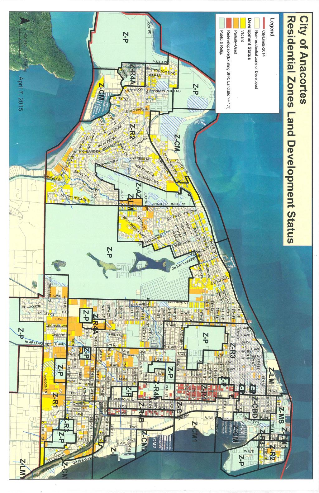
1 City of nacortes esidential & mployment Land Capacity nalysis Summary DFT Introduction The Growth Management ct (GM) requires that counties consult cities and allocate population growth within a range of projections provided by the ashington State Office of Financial Management (OFM). GM also requires that counties consult with cities and size their Urban Growth reas (UGs) based on growth over a 20-year period and that comprehensive plans and development regulations provide sufficient land capacity for development to accommodate allocated housing and employment growth (C and 115). City s Comprehensive Plans plan for their entire UGs, including within city limits and unincorporated areas of the UG. s part of their 2016 Comprehensive Plan updates, Skagit County and Cities are undergoing a process to update the countywide growth allocations, as it has been approximately 10 years since the last allocation. The Growth Management ct Steering Committee (GMSC) recommended by resolution to the County Commissioners revisions to Countywide Planning Policy #1, which outlines a process for growth allocation procedures. Cities have conducted land capacity analyses to determine if they can accommodate the initial targets within their UGs. esidential Land Capacity nalysis The initial 2036 population allocation for the nacortes Urban Growth (UG) area is 22,293 people, representing an additional 5,895 people from ssuming 2.25 people per household (per 2010 census data), an additional 2,620 dwelling units would need to be created within the nacortes UG to accommodate that population allocation. Summary stimated Population Capacity 1, 2, 3 4, 4, 4B CM, CM1 C CBD Total st. ddl Dus dd l Pop. Dwelling Units 1, ,300 5, Initial llocation 2,620 5, DU/population deficit (based on 2036 initial allocation) 320 DUs people The table above summarizes the results of an analysis that was conducted using the City s Geographic Information System (GIS), Skagit County ssessor Parcel data, and other information to estimate remaining residential capacity in the UG, under current zoning and development regulations. Page 1 of 8
2 The analysis indicates that under existing conditions, the City will be able to accommodate approximately 2,300 additional dwelling units through This is 320 dwelling units (720 people) less than the initial allocation of 2,620 dwelling units (or 5,895 people). Please note that the estimates provided in the above table represent staff s analysis of land capacity utilizing the method generally agreed to by the Technical dvisory Committee ( Planners Group ) to the Growth Management ct Steering Committee (GMSC). Modifications to methodology and assumptions have been made to address local circumstances and available information. These assumptions could be adjusted, resulting in different result capacity estimates, based on more detailed information and on community values identified through the comprehensive plan update process and/or PC/CC direction. Capacity nalysis arrative Definitions For the purposes of this analysis, the following definitions are used: Vacant Parcels of land that have no structures or have buildings with very little value (eg out buildings, etc.) Partially-used Parcels that are occupied by a use but which contains enough land to be further subdivided without need of rezoning. For instance, a single house on a 10-acre parcel, where urban densities are allowed, is partially developed. e-developable For multi-family zoning, parcels that are zoned for more intensive use than that which currently occupies the property. For instance, a single-family home on multi-family zoned land. parcel was considered re-developable if the assessed land value was greater than or equal to the assessed building value. Base Data Development For all zones, GIS data consisting of Skagit County ssessor s parcel information, aerial photography from 2011, the City s critical areas maps and other data were used to develop base information about each parcel s developable area and development status. Mapped critical areas and buffers were deducted from the overall area of each parcel. Parcels were classified as vacant, partially-vacant or redevleopable per the definitions above. esidential Zones Minimum lot size vs. maximum gross density ach residential zoning district identifies a minimum lot size and maximum gross density for new development. Per the nacortes Municipal Code, gross density is calculated using gross acreage, which is defined as acreage plus one-half the width of abutting rights-of-way of streets and alleys. Due to limited time and resources, calculation of this information on a site specific basis has not been possible and it is difficult to make blanket assumptions for an average figure due to unique circumstances of each property, for example, some sites may not currently abut any O and others may have 300 lineal feet abutting a 80-wide O. Therefore, for purposes of this analysis, estimated development capacity is presented as a range between the potential lot/unit yield using net site area density calculations and yield using minimum lot size. Page 2 of 8
3 1 (esidential Low Density) The maximum density permitted in the 1 zone is 2 dwelling units per gross acre and the minimum lot size is 15,000 square feet; however, through a Planned Unit Development (PUD) process, it is possible to develop using 2 standards (4 du/gr acre; min. lot size of 7,500 SF). For partially-used parcels, the estimated existing developed area (area with existing SF & yard, etc.) was deducted from the base data to arrive at the developable area. n infrastructure discount of 10% for vacant unplatted, and 5% for partially-used parcels was made. This was based on review of development patterns over the past 10 years that indicated on average, approximately 17% and 8% of subdivision and short subdivision sites, respectively, were comprised of streets, stormwater facilities, etc. ecognizing the fact that future development will need to comply with new DO stormwater regulations requiring implementation of low impact development standards, staff felt that the percentage of sites dedicated to streets and detention facilities is likely to decline in the next 20 years, hence reduction factors of 10% for vacant unplatted, and 5% for partially-used were used. The remaining developable area was then divided by the minimum lot size, and multipled by the maximum density, for the underlying zone to identify the range of additional lots that could be developed. Finally, a market factor reduction of 15% for vacant and 20% for partially-used parcels was applied to account for developable land that may be held off the market during the 20-year planning horizon due to fluctuating market forces. market plus context discount of 60% was applied to redevelopable parcels and existing units were deducted from the number of additional units possible. The study identified approximately 26 existing platted vacant lots, 13 un-platted vacant parcels, 34 partially-used parcels and 3 re-developable parcels with an estimated development capacity of approximately 152 additional lots/units based on minimum lot size, and 124 additional lots/units based on net density (assuming development using 1 standards). 2 (esidential Low Density) The maximum density permitted in the 2 zone is 4 dwelling units per gross acre and the minimum lot size is 7,500 square feet. Duplexes are permitted on minimum 9,000 square foot lots with a conditional use permit. stimated additional unit capacity for the 2 zone utilized the same process as for the 1 zone noted above. The study identified 465 existing platted vacant lots, 117 unplatted vacant lots, 107 partially-used lots and 59 redevelopable lots, with an estimated development capacity of 1,148 additional lots/units using minimum lots size or 924 lots/units using net density. 3 (esidential Medium Density) The maximum density permitted in the 3 zone is 9 dwelling units per gross acre and the minimum lot size is 6,000 square feet. Duplexes are permitted on minimum 7,500 square foot lots, and triplexes and fourplexes by conditional use permit on minimum 10,000 and 12,500 square foot lots, respectively. Page 3 of 8
4 stimated additional unit capacity for the 3 zone utilized the same process as for the 1 and 2 zones noted above. The study identified 26 existing platted vacant lots, 12 vacant unplatted lots, 39 partially-used lots and 22 redevleopable lots, for an estimated development capacity of 189 additional lots/units using minimum lots size or 290 units using net density. 3 Old Town Overlay The maximum density permitted in the Old Town Overlay district is 9 dwelling units per gross acre and the minimum lot size is 6,000 square feet. Duplexes are permitted on minimum 7,500 square foot lots, triplexes and fourplexes are not permitted. stimated additional unit capacity for the 3 zone utilized the same process as for the 1, 2 and 3 zones noted above. The study identified 3 existing platted vacant lots, 0 vacant unplatted lots, 3 partially-used lots and 5 redevelopable lots, for an estimated development capacity of 10 additional lots/units using minimum lots size and 18 lots/units using net density. 4 (esidential High Density) The 4 zone allows single family and multi-family dwellings as well as various neighborhood service-type uses. The maximum density permitted is 28 dwelling units per gross acre and the minimum lot size is 3,000 square feet for the first unit and 1,200 square feet for each additional unit. stimated additional unit capacity for the 4 zone utilized the same process as for the other residential zones noted above except that no deductions were made for infrastructure, the entire site area was used to determine potential number of units based on minimum lot size requirements and the derived number was reduced by one to account for the existing dwelling unit. market and context discount of 60% was applied to redevelopable parcels, based on past trends and existing regulatory barriers to development. There were no vacant properties identified in the 4 zone. ssuming that redevelopment of redevelopable parcels occurs lot by lot, rather than a larger basis, such as a block or ½ block, the additional unit capacity in the 4 zone is estimated at 146 additional units using minimum lot size or 185 units using net density. It is worth noting that the 4 zone has a maximum density of 28 dwelling units per gross acre, which is a higher density than can actually be achieved due to the minimum lot size per unit requirements. This is illustrated in the table below: 4 ½ Block xample # units allowed (based on min. lot size) rea (SF) Lot area 30, O rea (assumes 80 Os; 16 alley) +22,400 Gross area 52, # units allowed (based on density) Page 4 of 8
5 4 6,000 SF lot example # units allowed (based on min. lot size) rea (SF) Lot area O area (assumes 60 frontage on 80 wide O & 60 frontage on 16 alley) Gross area # units allowed (based on density) lso, the average lot size of the redevelopable lots in the 4 zone is 6,504 square feet, which would allow a maximum of three units per lot, including the existing unit, if redeveloped on an individual basis, under current development regulations. 4 (esidential High Density Two ()) The 4 zone allows single family and multi-family dwellings as well as various neighborhood service-type uses. The maximum density permitted is 18 dwelling units per gross acre and the minimum lot size is 3,000 square feet for the first unit and 1,200 square feet for each additional unit. stimated additional unit capacity for the 4 zone utilized the same process as for the 4 zone noted above. market plus context discount of 15% was applied to vacant parcels. The study identified four vacant parcels and 22 redevelopable parcels, with an adjusted capacity of 60 units based on minimum lot size and 55 based on net density. Developed parcels in the Skyline area zoned 4 were not considered as part of this analysis. 4B (esidential High Density Two (B)) The 4B zone allows single family and multi-family dwellings as well as various neighborhood service-type uses and uses supportive of manufacturing. The maximum density permitted is 18 dwelling units per gross acre and the minimum lot size is 3,000 SF for SFs, 6,000 SF for duplexes, 7,500 SF for triplexes and 9,000 SF for fourplexes. For multifamily beyond a fourplex, the requirement is 6,000 SF square feet for the first unit and 1,200 SF for each additional unit. stimated additional unit capacity for the 4B zone utilized the same process as for the 4 & 4 zones noted above. The study did not identify any vacant properties and found 42 redevelopable parcels, with an adjusted capacity of 9 units based on minimum lot size and 23 units based on net density. It should be noted that within this zone, of the 42 partially-used parcels identified, only 6 are 7,500 SF or larger (largest is 9,000 SF), meaning that only 14% of the underdeveloped parcels are large enough to accommodate a triplex or larger, if developed individually, under current development regulations. ccessory Dwelling Units DUs are permitted in all residential zones. ccording to City permitting data, a total of 18 DU permits have been processed since 2010, an average of 4 per year. ssuming this rate continues, a total of 80 DUs will have been constructed over the next 20 years. Staff expects that this number will increase moving forward, and that a rate of 10 per year or more may be more likely as they gain in popularity. Page 5 of 8
6 on-esidential Zones Commercial (C) The Commercial zone permits multifamily units above the first floor, with a maximum density of 28 dwelling units per gross acre. esidential uses are only permitted above the first floor. There is no minimum lot size in the Commercial zone. Potential residential unit capacity was conservatively estimated by using only the site area, not including ½ of the adjacent O width, as permitted by the code. Therefore, it could be assumed that the number of potential units reported below is likely higher than those calculated. Due to the requirement to have a commercial use on the ground floor, the capacity numbers assume that 10% of vacant and 6% of redevelopable Commercial properties will develop with residential / mixed uses. The study found 16 vacant parcels in the C zone with an estimated residential capacity of 8 units. There are 27 parcels in the C zone are currently developed with a SF where the land to building value ratio is greater than 1:1, representing development capacity potential of 4 additional units based on net site area. There are 172 non-residential parcels in the zone with a land to building value ratio of greater than 1:1, resulting in an additional unit estimate of 75 units. Central Business District (CBD) The CBD zone allows multifamily units above the first floor. There is no maximum density or minimum lot size in this zone. Staff reviewed several examples of redevelopment in CBD to determine potential density assumptions for the analysis. The ew ilson Hotel, which was renovated to include 25 multifamily units on a 10,000 SF lot (0.48 gross acres), resulted in a built net density of du/acre or du/gross acre. o on-site parking was provided with this development, however. nother project, which has not been built, but provides an example of potential mixed use development in the CBD zone, is the McKee est Plaza project, proposed at the corner of Commercial ve. & 10 th Street. The proposal included 28,000 square feet of commercial space and 32 condominium units on one-half block (30,000 square feet) with structured parking, resulting in a net density of 46 du/acre or 25 du/gross acre. For purposes of this analysis, 40 dwelling units per net acre was chosen based on the above examples. et acres (or site area, rather than gross acres) was used due to the difficulty in projecting adjacent O size for each property. Due to the requirement to have a commercial use on the ground floor, the capacity numbers assume that 10% of vacant and 6% of redevelopable Commercial properties will develop with residential uses. The study found 6 vacant parcels in the CBD zone with an estimated residential capacity of 4 units. There are 38 parcels in the CBD zone are currently developed with a SF where the land to building value ratio is greater than 1:1, representing development capacity potential of 9 additional units based on net site area. There are 100 non-residential parcels in the zone with a land to building value ratio of greater than 1:1, resulting in an additional unit capacity estimate of 36 units. Page 6 of 8
7 esidential development in the CM & CM1 zones Single family development is a conditional use in the CM zone and not permitted in the CM1 zone. Multifamily development is a conditional use in the CM and CM1 zones. Potential residential unit capacity was conservatively estimated by using only the site area, not including ½ of the adjacent O width, as permitted by the code. Therefore, it could be assumed that the number of potential units is likely higher than those calculated. Due to the regulatory requirement to obtain a CUP for residential development, the capacity numbers assume that only 10% of vacant and 6% of redevelopable CM properties will develop with residential uses. In the CM zones, which are located near the Ferry Terminal and in Skyline, multiple single family residential subdivisions have been approved through the CUP process in the last 10 years. The Portalis, San Juan Passage, Channel Landing (88) and Fidalgo Villas (19) developments have approximately 107 platted vacant lots remaining on which to build. The current Comprehensive Plan identifies the Leeward property as potentially accommodating a 100 units. This results in a total of 207 approved, existing or potential single family lots in the CM zone. There is additional capacity through redevelopment of existing sites within this zone under current zoning with mixed use buildings. Only 20% were assumed to develop based on requirement for CUP and because redevelopment would be needed. This capacity is estimated at 176 units, for a total of 383 units in the CM zone. In the CM1 zone the MJB property near 17 th St. is listed in the current Comprehensive Plan as potentially accommodating 150 units, which is consistent with the capacity estimates used within this study. Commercial and Industrial Lands mployment Capacity The City has 11 commercial and industrial zoning districts that provide for a variety of building intensities and uses. These zones include the irport Zone (Z), Commercial (C), Central Business District (CBD), Commercial Marine (CM), Commercial Marine 1 (CM1), Commercial Marine 2 (CM2), Heavy Manufacturing (HM), Industrial (I), Light Manufacturing (LM), Light Manufacturing 1 (LM1), and Manufacturing / Shipping (M/S). To quantify the amount of land available for employment uses, a similar process to the residential land capacity was used to assemble the base data. For all zones, GIS data consisting of Skagit County ssessor s parcel information, aerial photography from 2011, the City s critical areas maps and other data were used to develop base information about each commercial/industrial parcel s developable area and development status. Mapped critical areas and buffers were deducted from the overall area of each parcel. Parcels were classified as vacant or partially-vacant. Following collection of the above-referenced base data, 10% of the square footage was taken out to account for access ways and stormwater facilities. 15% market factor reduction was also applied to account for land that may not be available for development over the planning period. Further reduction to site area was made for areas that also allow residential development. In those zones (C, CBD, CM, and Page 7 of 8
8 CM1) 10% of the site area was assumed to develop with residential uses, considering existing development regulations. (vacant & part vacant) less critical areas (ac) 10% infrastructure reduction (ac) 15% market factor reduction (ac) % assumed to develop w/ nonres. use et area (ac) assumed # emp./acre st. dd l mp. Capacity C % I % LM % ,483 HM % CBD % CM % CM % CM % LM % MS % GD TOTL ,274 Page 8 of 8
9
10 City of nacortes Commercial/Industrial Vacant/Part-Vacant Land K O COPPMI D JU V GL SG O BL KL D S CPSS D L OS PL MIO CLD T L HIGHLD D B CH D BC D CO H D Z-LM O 1,340 Feet Z-Z TI L B P C SKLI COHO L SHO PO IT D D TO B LV G L SH IG PUG T PKSID D D M JSP 0 1 COPP POD D D C DO D O O TI VI CT V Z-2 D OV DU O KSHI D S D PL G KI V CO S M GU DL L PL M LIG D PL PIP CI B Z-4 OF Vacant I O OS PI S L T C ITIM I DB H PL BTSO CT Unbuildable SU V L SUG Part-used & Underutilized O S etc. OOP D LParks/Public, M C D 4 5 T 6 HS 7 T S K Developed LIS T O P OO 4 V Dev_Status H SC D T T U IO OH <all other values> C Legend DFT TLDS-2015 D 3 ISL V S D 2 OGO V O CK I DG PK pril 9, 2015 Z-LM
11 U V M V K TS T L V V Q V Q V L V V J V J V J V Q V T V V PL V V T Z-I Z-I HDDO L Z-3 Z-1 V V V S V 38 LOGVI V O V V U V O V K V M V L V I V H V CH L OCHD V V V D CT MI O V I V F V FILD V S U SP 20 S D LL H 31 33D V KIG FI C BLVD COMMCIL V H V I V V I V C V CSCD CT K V F V G V H V I V PK G ID K O C L G TS HIGH CD T L D 35 PL Z-4B 2 36 Z ,750 Feet 2 D D 32D CT 42D PL Z-I O B B C Z-2 Z-4 26 C MIT M I L D Z-C G FIDL B V GL SG O G SID L 27 PL PL 29 VI Z D 24 CT G V KI S 16 V D JSP 24 /Q K L Z-C 20 ISLD VI PL 23D H 2T 1 Z-LM V 17 L GI P GO CK V T SO Vacant Z MI Unbuildable D V D PL Z-CBD Part-used & Underutilized Z-Z D V V COPPMI D B S HIO O Parks/Public, etc. S K ISL D <all other values> Developed 3 C TLDS-2015 V OT V KS O D 2 V DK Legend L TO Dev_Status IG V Z-LM 11 DFT 3D V City of nacortes Commercial/Industrial Vacant/Part-Vacant Land pril 9, 2015 Z-MS 1 4 Z-2 Z-CBD Z-3 5 2D
12 FID City of nacortes Z-2 Commercial/Industrial Vacant/Part-Vacant Land Z-1 O LG B pril 9, 2015 D DFT Legend TLDS-2015 <all other values> Dev_Status Z-HM Developed Parks/Public, etc. Part-used & Underutilized Z-LM1 P U Vacant S S 2 0 Unbuildable OLD BOOK L SUMMIT PK D VSO D ,750 Feet D D M T POI IGHT S SO U `S CH PDI LL H T SVTIO D SC C DI MCH POIT D
City of Bellingham Urban Growth Area - Land Supply Analysis Summary
 City of Bellingham Urban Growth Area - Land Supply Analysis Summary Population & Employment Growth Forecasts APPENDIX D, ATTACHMENT 3 The ECONorthwest Whatcom County Population & Economic Forecasts report
Buildable Lands Analysis within the Overall UGB Expansion Process
 CHAPTER 3. BUILDABLE LANDS ANALYSIS The buildable lands inventory is intended to identify lands that are available for development within the UGB. The inventory is sometimes characterized as supply of
Table 4d-1. City of Poulsbo Residential Building Permits CITY OF POULSBO Unit Type
 City of Poulsbo Growth from 2006-2012 OFM City of Poulsbo Population Estimate Highlights The City of Poulsbo had a 2006 population of 7,722 The City of Poulsbo had a 2012 population of 9,360 Resident population
Procedures For Collecting and Monitoring Data
 DRAFT Kitsap County Buildable Lands Program Procedures For Collecting and Monitoring Data Page 1 12/1/05 Introduction This procedures report is intended to provide guidelines for Kitsap County and its
2018 RESIDENTIAL CAPACITY AND VACANT LAND ANALYSIS. Martin County Board of County Commissioners
 2018 RESIDENTIAL CAPACITY AND VACANT LAND ANALYSIS Martin County Board of County Commissioners Approved February 13, 2018 INTRODUCTION Objective 4.1D of the Martin County Comprehensive Growth Management
Build-Out Analysis. Methodology
 Build-Out Analysis Methodology PRINCE WILLIAM COUNTY PLANNING OFFICE 5 County Complex Court Prince William, Virginia 22192-9201 (703) 792-7615 www.pwcgov.org/planning Christopher M. Price, AICP Director
TOWN OF BROOKLINE, NEW HAMPSHIRE
 TOWN OF BROOKLINE, NEW HAMPSHIRE BUILDOUT ANALYSIS DECEMBER, 2003 Prepared by the Nashua Regional Planning Commission TABLE OF CONTENTS Introduction... 1 I. Methodology... 1 A. PARCEL REVIEW... 1 B. DEVELOPMENT
Gold Beach Buildable Lands Analysis
 Gold Beach Buildable Lands Analysis Final Report Submitted to: City of Gold Beach Prepared by: Community Planning Workshop Community Service Center 1209 University of Oregon Eugene, OR 97403-1209 http://darkwing.uoregon.edu/~cpw
Item # 9 September 13, 2006
 Item # 9 September 13, 2006 Planning and Development Department Land Use Planning Division To: From: Planning Commission Allan Gatzke Principal Planner Memorandum Date: September 13, 2006 Subject: Housing
Marion County Board of County Commissioners
 Marion County Board of County Commissioners Date: 12/29/2015 P&Z: 12/28/2015 BCC: 1/12/2016 Item Number 160113Z Type of Application Rezoning Request From: A-1 (General Agriculture) To: PUD (Planned Unit
Baltimore County Public Schools Dogwood Elementary School Capacity Relief Study. Meeting 4 Option Analysis
 ogwood lementary School Capacity elief Study eeting 4 Option nalysis evised: 03/19/2019 2018-19 Capacity, 2018-19 Official nrollment, Live ttend Counts, and Building Utilizations The following are school
Watertown City Council
 City of Watertown Watertown City Council 2/14/2017 Agenda Item: Riverpointe Subdivision 2 nd Replat Request for Action: Sketch Plan Department: Planning Request for Action Request: Paxmar, LLC (Applicant)
CITY OF MEDFORD COMPREHENSIVE PLAN BUILDABLE LAND INVENTORY
 CITY OF MEDFORD COMPREHENSIVE PLAN PREPARED BY CITY OF MEDFORD PLANNING DEPARTMENT 200 SOUTH IVY STREET MEDFORD, OREGON 97501 BIANCA PETROU, A.I.C.P., ACTING PLANNING DIRECTOR LONG RANGE PLANNING SECTION
Cabarrus County, NC Adequate Public Facilities Ordinance. Contents
 Contents Section 15. Adequate Public Facilities Standards.... 2 Section 15-1. Introduction.... 2 Section 15-2. How to Use this Chapter.... 3 Section 15-3. Basic Terms and Definitions... 4 Section 15-4.
Land Use Survey Summer 2014
 Land Use Survey Summer 2014 North Ogden City, Utah Robert Scott, City Planner Travis Lund, Planning Intern Contents General Information... 1 Land Use Groups... 1 Urbanized Land Uses... 1 Residential...
Infill Housing Analysis
 City of Victoria Proposed Fairfield and Gonzales Neighbourhood Infill Housing Analysis Urbanics Consultants Ltd. Proposed Fairfield and Gonzales Neighbourhood Infill Housing Analysis Victoria, B.C. Prepared
3. FISCAL IMPACT ANALYSIS FISCAL IMPACT ANALYSIS 29
 3. FISCAL IMPACT ANALYSIS FISCAL IMPACT ANALYSIS 29 The purpose of fiscal impact analysis is to estimate the impact of a development or a land use change on the budgets of governmental units serving the
CHAPTER 2 VACANT AND REDEVELOPABLE LAND INVENTORY
 CHAPTER 2 VACANT AND REDEVELOPABLE LAND INVENTORY CHAPTER 2: VACANT AND REDEVELOPABLE LAND INVENTORY INTRODUCTION One of the initial tasks of the Regional Land Use Study was to evaluate whether there is
RESOLUTION NO ( R)
") RESOLUTION NO. 2013-06- 088 ( R) A RESOLUTION OF THE CITY COUNCIL OF THE CITY OF McKINNEY, TEXAS, APPROVING THE LAND USE ASSUMPTIONS FOR THE 2012-2013 ROADWAY IMPACT FEE UPDATE WHEREAS, per Texas Local
RESOLUTION NO. 2013-06- 088 ( R) A RESOLUTION OF THE CITY COUNCIL OF THE CITY OF McKINNEY, TEXAS, APPROVING THE LAND USE ASSUMPTIONS FOR THE 2012-2013 ROADWAY IMPACT FEE UPDATE WHEREAS, per Texas Local
Marion County Board of County Commissioners
 Marion County Board of County Commissioners Date: 6/28/2017 P&Z: 6/26/2017 BCC: 7/18/2017 Item Number 170701Z Type of Application Rezoning Request B-2, Community Business to R-1, Single Family Residential
PALM BEACH COUNTY PLANNING, ZONING AND BUILDING DEPARTMENT ZONING DIVISION
 PALM BEACH COUNTY PLANNING, ZONING AND BUILDING DEPARTMENT ZONING DIVISION Application No.: Z-2014-01627 Application Name: Dazco Center Control No.: 2003-00040 Applicant: 4730 Hypoluxo LLC Owners: 4730
STAFF REPORT. Permit Number: Unlimited. Kitsap County Board of Commissioners; Kitsap County Planning Commission
 STAFF REPORT Permit Number: 15 00550 Unlimited DATE: March 2, 2016 TO: FROM: Kitsap County Board of Commissioners; Kitsap County Planning Commission Katrina Knutson, AICP, Senior Planner, DCD and Jeff
Yakima County Public Services Department Planning Division
 Yakima County Public Services Department Planning Division Yakima County s 2017 Review of its UGAs and Permitted Densities (as required by the Growth Management Act) Urban Growth Area for City of Zillah
LAND USE ELEMENT CITY OF HAWTHORNE GENERAL PLAN
 LAND USE ELEMENT CITY OF HAWTHORNE GENERAL PLAN Adopted April, 1990 Last amended March, 2016 Prepared by: Cotton/Beland/Associates, Inc. 1028 North Lake Avenue, Suite 107 Pasadena, California 91104 TABLE
Marion County Board of County Commissioners
 Marion County Board of County Commissioners Date: 10/29/25 P&Z: 10/26/25 BCC: 11/17/25 Item Number 151106SU Type of Application Special Use Permit Request Special Use Permit Modification to: 1. Add a secondary
TASK 2 INITIAL REVIEW AND ANALYSIS U.S. 301/GALL BOULEVARD CORRIDOR FORM-BASED CODE
 TASK 2 INITIAL REVIEW AND ANALYSIS U.S. 301/GALL BOULEVARD CORRIDOR FORM-BASED CODE INTRODUCTION Using the framework established by the U.S. 301/Gall Boulevard Corridor Regulating Plan (Regulating Plan),
Appendix J - Planned Unit Development (PUD)
") Appendix J - Planned Unit Development (PUD) Intent and Purpose The purpose of the PUD is: 1. To provide development that is consistent with the Comprehensive Land Use Plan and promote the goals and objectives
Appendix J - Planned Unit Development (PUD) Intent and Purpose The purpose of the PUD is: 1. To provide development that is consistent with the Comprehensive Land Use Plan and promote the goals and objectives
Vacant Corner Lot in Golden Gate
 FOR SALE $79,000 Property Details PRICE $79,000 PARCEL ID 37-38-41-007-032-00070-7 LAND SIZE 11,000 sf Great corner vacant lot in the Golden Gate area of Stuart. Site is comprised of 4 lots with the with
Kitsap County Department of Community Development 619 Division Street, MS-36 Port Orchard, WA 98366
 Kitsap County Department of Community Development 619 Division Street, MS-36 Port Orchard, WA 98366 ACKNOWLEDGEMENTS Kitsap County Board of Commissioners District 1 Robert Gelder District 2 Charlotte Garrido
Town of North Topsail Beach
 Town of North Topsail Beach Build-Out and Non-Conforming Lot Study In Coordination with The Eastern Carolina Council of Governments February 2010 Introduction The Town of North Topsail Beach has conducted
Planning & Zoning Commission Meeting Date: December 3, 2012
 Planning and Development Department City of League City Planning & Zoning Commission Meeting Date: December 3, 2012 Requests Rezone approximately 3.3 acres from RSF-5 (Single-family residential with a
Berry/University Form Based Code and Urban Residential Development
 Berry/University Form Based Code and Urban Residential Development Presented to the City Council by the Planning and Development Department October 11, 2016 Purpose Review proposed Berry/University formbased
Final Draft Ordinance: Matrix
 1. # Topic Title And Description Dry Sewer olicy Use table footnote 48 revised to include a reference to exemptions in K 17.460.0. Allow properties within an Urban Growth Area, that are too far from sewer,
ARTICLE 3: Zone Districts
 ARTICLE 3: Zone Districts... 3-1 17.3.1: General...3-1 17.3.1.1: Purpose and Intent... 3-1 17.3.2: Districts and Maps...3-1 17.3.2.1: Applicability... 3-1 17.3.2.2: Creation of Districts... 3-1 17.3.2.3:
BUILD-OUT ANALYSIS GRANTHAM, NEW HAMPSHIRE
 BUILD-OUT ANALYSIS GRANTHAM, NEW HAMPSHIRE A Determination of the Maximum Amount of Future Residential Development Possible Under Current Land Use Regulations Prepared for the Town of Grantham by Upper
Lacey UGA Residential density
 Thurston County Planning Department BOARD OF COUNTY COMMISSIONERS PUBLIC HEARING DRAFT AMENDMENTS TO THE CRITICAL AREAS REGULATIONS Residential density amendment to Title 21 Title 21 6/1/2012 Lacey UGA
Staff Report: Date: Applicant: Property Identification: Acreage of Request: Current Zoning of Requested Area: Requested Action: Attached:
 Staff Report: Completed by Jeff Palmer Director of Planning & Zoning Date: November 7, 2018, Updated November 20, 2018 Applicant: Greg Smith, Oberer Land Developer agent for Ronald Montgomery ET AL Property
CITY OF NAPLES STAFF REPORT
 Meeting of 11/9/16 Subdivision/Replat Petition 16-SD3 CITY OF NAPLES STAFF REPORT To: Planning Advisory Board From: Planning Department Subject: Subdivison/Replat Petition 16-SD3 Petitioner: Matthew Grabinski,
Marion County Board of County Commissioners
 Marion County Board of County Commissioners Date: 12/2/2015 P&Z: 11/30/2015 BCC: 12/16/2015 Item Number 151210SU Type of Application Special Use Permit Request To establish a Clay Electric Co-Operative
2030 General Plan. December 6, 7 pm
 2030 General Plan GPAC Meeting #9 GPAC Meeting #9 December 6, 7 pm City Council Input on Working Draft Land Use Map Council discussed GPAC & PC versions of the working draft land use map 11/28 Council
2014 Plan of Conservation and Development. Development Plan & Policies
 The Town of Hebron Section 3 2014 Plan of Conservation and Development Development Plan & Policies C. Residential Districts I. Residential Land Analysis This section of the plan uses the land use and vacant
Tallahassee Land Development Regulations
 Tallahassee Land Development egulations Sec. 10170. esidential reservation District (a) urpose and Intent. (1) The district is characterized by existing homogeneous residential areas within the community
2005 COTTAGE GROVE BUILDABLE LANDS ANALYSIS UPDATE
 2005 COTTAGE GROVE BUILDABLE LANDS ANALYSIS UPDATE Adopted June 13, 2005 Prepared by Satre Associates, P.C. Planners, Landscape Architects and Environmental Specialists 132 East Broadway, Suite 536 Eugene,
PALM BEACH COUNTY PLANNING, ZONING AND BUILDING DEPARTMENT ZONING DIVISION. ZONING COMMISSION VARIANCE STAFF REPORT February 07, 2013
 PALM BEACH COUNTY PLANNING, ZONING AND BUILDING DEPARTMENT ZONING DIVISION ZONING COMMISSION VARIANCE STAFF REPORT February 07, 2013 APPLICATION NO. CODE SECTION REQUIRED PROPOSED VARIANCE ZV-2012-03383
PORTLAND PLAN. Household and Employment Forecasts and Development Capacity
 PORTLAND PLAN Household and Employment Forecasts and Development Capacity Managing Change In recent decades, the Portland Metropolitan region and the City of Portland experienced a steady increase in population.
Single Family Residential
 Housing Development Tools Single Family Residential Single Family Residence 1 Current Accessory Apartment Ordinance Single Family Residence 600 Square Foot Accessory Apartment (Net Floor Area) Twice Minimum
CITY OF COCOA BEACH DEPARTMENT OF DEVELOPMENT SERVICES PLANNING BOARD BRIEFING Meeting Date: April 3, 2017 Agenda Item: C.1
 REQUEST: Comprehensive Plan Amendment and Rezoning request to change the Future Land Use from High Density Residential & Professional to General Commercial and change the Zoning designation from RM-2 Multifamily-
Portland Streetcar Development Impacts
 Portland Streetcar Development Impacts Review Draft Prepared for: Portland Streetcar Inc. October 2005 Prepared by: E.D. Hovee & Company, LLC P.O. Box 225 2408 Main Street Vancouver, Washington 98666 (360)
2.2 Future Demand Projection Methodology
 SECTION 2 Water Demands Water demands were developed for existing and future conditions based on parcel-level land use information and water meter billing data. CH2M HILL worked extensively with Town of
Marion County Board of County Commissioners
 Marion County Board of County Commissioners Date: 12/2/25 P&Z: 11/30/25 BCC: 12/16/25 Amendment No: (20)151209Z Type of Application Rezoning Request P-MH (Mobile Home Park) to B-2 (Community Business)
PLANNING COMMISSION REPORT Regular Agenda - Public Hearing Item
 Z-14-00056 Item No. 1-1 PLANNING COMMISSION REPORT Regular Agenda - Public Hearing Item PC Staff Report 4/21/2014 ITEM NO. 1: RSO TO CN1;.126 ACRES; 512 & 514 LOCUST ST (DRG) Z-14-00056: Consider a request
PLANNING COMMISSION REPORT Regular Agenda Public Hearing Item PRD TO RM15; ACRES; 2101 EXCHANGE CT (KES)
") PC Staff Report 7/22/15 Z-14-00515 Item No. 3-1 PLANNING COMMISSION REPORT Regular Agenda Public Hearing Item PC Staff Report 7/22/15 ITEM NO. 3 PRD TO RM15; 9.818 ACRES; 2101 EXCHANGE CT (KES) Z-14-00515:
PC Staff Report 7/22/15 Z-14-00515 Item No. 3-1 PLANNING COMMISSION REPORT Regular Agenda Public Hearing Item PC Staff Report 7/22/15 ITEM NO. 3 PRD TO RM15; 9.818 ACRES; 2101 EXCHANGE CT (KES) Z-14-00515:
PALM BEACH COUNTY PLANNING, ZONING AND BUILDING DEPARTMENT ZONING DIVISION ZONING COMMISSION VARIANCE STAFF REPORT 06/05/2014
 PALM BEACH COUNTY PLANNING, ZONING AND BUILDING DEPARTMENT ZONING DIVISION ZONING COMMISSION VARIANCE STAFF REPORT 06/05/2014 APPLICATION NO. ZV-2013-03120 CODE SECTION REQUIRED PROPOSED VARIANCE (V1)
NEW AND REVISED. Organization, format and editing. Numbering, page layout, tables, charts, illustrations General editing and plain English voice
 NEW AND REVISED Organization, format and editing Numbering, page layout, tables, charts, illustrations General editing and plain English voice ORGANIZATION AND FORMAT Chapter 1 Introductory Provisions
TABLE (A): TABLE OF DIMENSIONAL STANDARDS IN THE RESIDENTIAL ZONE DISTRICTS REQUIRED YARDS [4], [5] SIDE YARD (FT) REAR YARD (FT) R-1 DISTRICT
![TABLE (A): TABLE OF DIMENSIONAL STANDARDS IN THE RESIDENTIAL ZONE DISTRICTS REQUIRED YARDS [4], [5] SIDE YARD (FT) REAR YARD (FT) R-1 DISTRICT](/thumbs/85/92855381.jpg "TABLE (A): TABLE OF DIMENSIONAL STANDARDS IN THE RESIDENTIAL ZONE DISTRICTS REQUIRED YARDS [4], [5] SIDE YARD (FT) REAR YARD (FT) R-1 DISTRICT") ARTICLE : DENSITY, INTENSITY, & DIMENSIONAL STANDARDS Section -100: General Provisions TABLE 17--100(A): TABLE OF DIMENSIONAL STANDARDS IN THE RESIDENTIAL ZONE DISTRICTS R-1 DISTRICT AREA (SQ FT)[3] WIDTH
ARTICLE : DENSITY, INTENSITY, & DIMENSIONAL STANDARDS Section -100: General Provisions TABLE 17--100(A): TABLE OF DIMENSIONAL STANDARDS IN THE RESIDENTIAL ZONE DISTRICTS R-1 DISTRICT AREA (SQ FT)[3] WIDTH
ARTICLE XVII SCHEDULE OF REGULATIONS
 ARTICLE XVII SCHEDULE OF REGULATIONS SECTION 1700. LIMITING HEIGHT, BULK, DENSITY, AND AREA BY DISTRICT TYPE Use Minimum Size Lot Per Unit Maximum Height of Structures Minimum Yard Setback (Per Lot in
Town of Prescott Valley 2013 Land Use Assumptions
 Town of Prescott Valley 2013 Land Use Assumptions Raftelis Financial Consultants, Inc. November 22, 2013 Table of Contents Purpose of this Report... 1 The Town of Prescott Valley... 2 Summary of Land Use
Technology Park Planned Unit Development Technology Park PUD-IP
 Technology Park Planned Unit Development Technology Park PUD-IP Rob Anderson Community Development Director Planned Unit Development Background 2 Planned Unit Development (PUD) means a mixed use redevelopment
PALM BEACH COUNTY PLANNING, ZONING AND BUILDING DEPARTMENT ZONING DIVISION
 PALM BEACH COUNTY PLANNING, ZONING AND BUILDING DEPARTMENT ZONING DIVISION Application No.: CA-2012-00688 Control No.: 2011-00552 Applicant: Garry Bernardo Owners: Garry Bernardo Agent: Frogner Consulting,
Burlington Unincorporated Community Plan
 Burlington Unincorporated Community Plan June 30, 2010 Meeting Page 1 of 24 Table of Contents (Page numbers to be inserted) I. Background a. Location and Community Description b. Planning of Unincorporated
TOWN OF PELHAM DEVELOPMENT CHARGE BACKGROUND STUDY OFFICE CONSOLIDATION NOVEMBER 4, (As Amended March 5 th and April 28 th, 2014)
") TOWN OF PELHAM DEVELOPMENT CHARGE BACKGROUND STUDY OFFICE CONSOLIDATION NOVEMBER 4, 2013 (As Amended March 5 th and April 28 th, 2014) CONTENTS EXECUTIVE SUMMARY Page (i) 1. INTRODUCTION 1.1 Purpose of
TOWN OF PELHAM DEVELOPMENT CHARGE BACKGROUND STUDY OFFICE CONSOLIDATION NOVEMBER 4, 2013 (As Amended March 5 th and April 28 th, 2014) CONTENTS EXECUTIVE SUMMARY Page (i) 1. INTRODUCTION 1.1 Purpose of
Exhibit B RESOLUTION NO.
 Exhibit B RESOLUTION NO. RESOLUTION OF THE CITY COUNCIL OF THE CITY OF PLACERVILLE AMENDING THE PLACERVILLE GENERAL PLAN LAND USE SECTION - PART I: LAND USE/CIRCULATION DIAGRAMS; AMENDING THE GENERAL PLAN
Analysis of Infill Development Potential Under the Green Line TOD Ordinance
 Analysis of Infill Development Potential Under the Green Line TOD Ordinance Prepared for the Los Angeles County Second Supervisorial District Office and the Department of Regional Planning Solimar Research
ARTICLE C. ZONING TEXT, DISTRICT CLASSIFICATIONS AND BOUNDARIES
 ARTICLE C. ZONING TEXT, DISTRICT CLASSIFICATIONS AND BOUNDARIES Sec. 10-2054. ZONING TEXT, DISTRICT CLASSIFICATIONS AND BOUNDARIES. In order to regulate the location of structures, the height and bulk
Dr af t Sant a Bar b ar a Count y Housing Elem ent
 6. LAND INVENTORY AND QUANTIFIED OBJECTIVE I n t r o d u c t i o n This chapter includes two important components of the Housing Element: (1) the land inventory and analysis, and (2) the quantified objective
FORT MYERS, FLORIDA GATEWAY 54 ACRES MIXED USE PLANNED DEVELOPMENT OFFERING MEMORANDUM. Index
 FORT MYERS, FLORIDA GATEWAY 54 ACRES MIXED USE PLANNED DEVELOPMENT OFFERING MEMORANDUM Index 1. Executive Summary 2. Location Maps 3. 4. 5. 6. 7. Property Aerial Conceptual Site Plan Zoning Resolution
Planning Department Oconee County, Georgia
 Planning Department Oconee County, Georgia STAFF REPORT REZONE CASE #: 6985 DATE: October 31, 2016 STAFF REPORT BY: Andrew C. Stern, Planner APPLICANT NAME: Williams & Associates, Land Planners PC PROPERTY
PALM BEACH COUNTY PLANNING, ZONING AND BUILDING DEPARTMENT ZONING DIVISION ZONING COMMISSION VARIANCE STAFF REPORT 03/03/2011
 PALM BEACH COUNTY PLANNING, ZONING AND BUILDING DEPARTMENT ZONING DIVISION ZONING COMMISSION VARIANCE STAFF REPORT 03/03/2011 APPLICATION NO. CODE SECTION REQUIRED PROPOSED VARIANCE ZV-2010-02817 3.D.1.C
Faribault Place 3 rd Addition Preliminary Plat, Final Plat, & PUD
 Faribault Small Town Pride Big City Opportunities! December 5, 2016 Planning Commission Public Hearing Faribault Place 3 rd Addition Preliminary Plat, Final Plat, & PUD Location Maps Faribault 2 Requests
Generic Environmental Impact Statement. Build-Out Analysis. City of Buffalo, New York. Prepared by:
 Generic Environmental Impact Statement Build-Out Analysis City of Buffalo, New York 2015 Prepared by: TABLE OF CONTENTS 1.0 INTRODUCTION 1 2.0 METHODOLOGY 2 3.0 EXISTING LAND USE 3 4.0 EXISTING ZONING
Land Capacity Analysis
 Land Capacity Analysis City of Minneapolis Land Capacity Analysis June 2010 Submitted to: City of Minneapolis Community Planning & Economic Development Community Attributes tells data-rich stories about
CITRUS COUNTY COMPREHENSIVE PLAN
 CITRUS COUNTY COMPREHENSIVE PLAN APPENDIX F METHODOLOGIES USED IN THE FUTURE LAND USE ELEMENT REFERENCED IN CHAPTER 10 FUTURE LAND USE Updated: December 2, 1997, Ord. No. 1997-A29 This page left intentionally
Housing. Approved and Adopted by City Council November 13, City Council Resolution City Council Resolution
 5 Housing Approved and Adopted by City Council November 13, 2018 Chapter 5 Housing 5.1 City Council Resolution 2018-096 5.2 Fontana General Plan CHAPTER 5 Housing This chapter of the General Plan Update
Salem HNA and EOA Advisory Committee Meeting #6
 Salem HNA and EOA Advisory Committee Meeting #6 Residential Land Policies Employment Land Policies Policy Discussions with the Committee Outcome of today s meeting Direction from this Committee on proposed
CHAPTER 4. MANAGER Single-Family Multi-Family Total. CHAPTER 4: AREA OF IMPACT AND BUILDOUT ANALYSIS Housing Needs Analysis
 The Area of Impact, the areas that Blueprint Boise identifies as potential annexation areas, have come up in several conversations with city officials in the context of the housing analysis. The Area of
this page left intentionally blank DENVER ZONING CODE
 Article 1. GENERAL PROVISIONS this page left intentionally blank Contents ARTICLE 1. GENERAL PROVISIONS DIVISION 1.1 GENERAL...1.1-1 Section 1.1.1 Purpose...1.1-1 Section 1.1.2 Intent...1.1-1 Section 1.1.3
Administration and Calculation of Servicing Agreement Fees and Development Levies
 Administration and Calculation of Servicing Agreement Fees and Development Levies Policy Title: Applies to: Reference # Administration and Calculation of Servicing Agreement Fees and City of Regina ###-XXX-##
Build-out Analysis. City of Cape Coral CITY OF CAPE CORAL Department of Community Development
 Build-out Analysis City of Cape Coral 2011 CITY OF CAPE CORAL Department of Community Development Division of Planning and Growth Management Cape Coral, Florida Derek C.S. Burr, AICP, MS, MPA, Division
Tallahassee Land Development Code
 Tallahassee Land Development Code Sec. 10-170. Residential reservation District (a) urpose and Intent. (1) The district is characterized by existing homogeneous residential areas within the community which
Town of Cary, North Carolina Rezoning Staff Report 12-REZ-27 Morris Branch Town Council Public Hearing January 24, 2013
 Town of Cary, North Carolina Rezoning Staff Report 12-REZ-27 Morris Branch Town Council Public Hearing January 24, 2013 REQUEST To amend the Town of Cary Official Zoning Map to rezone approximately 9.0
PALM BEACH COUNTY PLANNING, ZONING AND BUILDING DEPARTMENT ZONING DIVISION
 PALM BEACH COUNTY PLANNING, ZONING AND BUILDING DEPARTMENT ZONING DIVISION Petition No.: Z2003-017 Petitioner: Palm Beach County BCC Owner: Palm Beach County BCC Agent: Kilday and Associates Telephone
PLANNING COMMISSION REPORT Regular Agenda Public Hearing Item
 PC Staff Report 6/20/16 Item No. 4-1 PLANNING COMMISSION REPORT Regular Agenda Public Hearing Item PC Staff Report 06/20/16 ITEM NO. 4: IG to CS 1.56 ACRES; 706 E 23 RD STREET (MKM) : Consider a request
MEMORANDUM. Critical Areas Ordinance Density Requirements
 COUNTY COMMISSIONERS Creating Solutions for Our Future Cathy Wolfe District One Sandra Romero District Two Karen Valenzuela District Three PLANNING DEPARTMENT Scott Clark Director MEMORANDUM TO: FROM:
Article Floating Zone Requirements
 Division 5.1. In General Article 59-5. Floating Zone Requirements Section 5.1.1. Zone Categories There are 4 categories of Floating zones: A. Residential Floating zones (Division 5.2); B. Commercial/Residential
ORDINANCE NO. C 34911
 ORDINANCE NO. C 34911 AN ORDINANCE relating to Residential Zones; amending SMC sections 17C.110.020, 17C.110.030, 17C.110.100, 17C.110.205, 17C.110.220, 17C.110.245, 17C.110.310, Table 17C.110-3 and adopting
Buildout Numbers Task Force September 24, 2009
 Buildout Numbers Task Force September 24, 2009 Task Force Members Kristy Bruner/Paul Hansen Jackson Hole Conservation Alliance Scott Pierson/Hal Hutchinson Pierson Land Works Armond Acri Save Historic
STAFF REPORT. Permit Number: Laurier Enterprises, Inc. Kitsap County Board of Commissioners; Kitsap County Planning Commission
 STAFF REPORT Permit Number: 15 00740 Laurier Enterprises, Inc. DATE: December 18, 2015 TO: FROM: Kitsap County Board of Commissioners; Kitsap County Planning Commission Katrina Knutson, AICP, Senior Planner,
2. Rezone a portion of the lot from R2 (Small Lot Residential) to RD2 (Duplex: Housing Lane).
 to RD2 (Duplex: Housing Lane).") Public Notice September 6, 2018 Subject Property Subject Property: 337 Hastings Ave Lot 24, District Lot 1, Group 7, Similkameen Division Yale (Formerly Yale-Lytton) District, Plan 932 Application: The
Public Notice September 6, 2018 Subject Property Subject Property: 337 Hastings Ave Lot 24, District Lot 1, Group 7, Similkameen Division Yale (Formerly Yale-Lytton) District, Plan 932 Application: The
SUBCHAPTER 23-3: DENSITY AND INTENSITY REGULATIONS
 SUBCHAPTER 23-3: DENSITY AND INTENSITY REGULATIONS Section 23.301 Purpose The purpose of this Subchapter is to indicate the maximum permitted density (for residential projects) and maximum permitted intensity
Appendix A. Land Capacity Analysis Methodology. Unincorporated Kitsap County. City of Bainbridge Island. City of Bremerton.
 Appendix A Land Capacity Analysis Methodology Unincorporated Kitsap County City of Bainbridge Island City of Bremerton City of Poulsbo 1 KITSAP COUNTY 2005 UPDATED LAND CAPACITY ANALYSIS (ULCA) Prepared
Yarmouth County Registry of Deeds
 Record Type Volume Dates Indexes Reel Index 1A 1774-1792 18776 not at Archives Index 2 1785-1817 18776 not at Archives Index 3 1817-1832 18776 not at Archives Index 4 1832-1846 18776 not at Archives Index
City of Puyallup. Parks Impact Fee Study
 City of Puyallup Parks Impact Fee Study August 23, 2005 Prepared by Financial Consulting Solutions Group, Inc. 8201 164 th Avenue NE, Suite 300 Redmond, WA 98052 tel: (425) 867-1802 fax: (425) 867-1937
Provide a diversity of housing types, responsive to household size, income and age needs.
 8 The City of San Mateo is a highly desirable place to live. Housing costs are comparably high. For these reasons, there is a strong and growing need for affordable housing. This chapter addresses the
PALM BEACH COUNTY PLANNING, ZONING AND BUILDING DEPARTMENT ZONING DIVISION ZONING COMMISSION VARIANCE STAFF REPORT 5/7/2009
 PALM BEACH COUNTY PLANNING, ZONING AND BUILDING DEPARTMENT ZONING DIVISION ZONING COMMISSION VARIANCE STAFF REPORT 5/7/2009 APPLICATION NO. CODE SECTION REQUIRED PROPOSED VARIANCE ZV-2009-00991 3.F.4.D.10.b.1).
Pueblo Regional Development Plan, Addendum
 Pueblo Regional Development Plan, Addendum August 2014 Table of Contents Factual Foundation.1 Land Demand Analysis....1 Population Trends 2 Housing Trends..3 Employment Trends 4 Future Land Demand Summary.5
ECONOMIC ANALYSIS AND REDEVELOPMENT STRATEGY FOR THE NORTHWEST QUADRANT
 City of Roswell ECONOMIC ANALYSIS AND REDEVELOPMENT STRATEGY FOR THE NORTHWEST QUADRANT February 23, 2007 Prepared For: The City of Roswell Prepared By: TABLE OF CONTENTS 1.0 Introduction 3 2.0 Key Findings
Staff Report: Date: Applicant: Property Identification: Acreage of Request: Current Zoning of Requested Area: Requested Action: Attached:
 Staff Report: Completed by Jeff Palmer Director of Planning & Zoning Date: November 7, 2018 Applicant: Greg Smith, Oberer Land Developer agent for Ronald Montgomery ET AL Property Identification: Frontage
MAAO UMASS 2010 ANALYSIS AND VALUATION OF PRIME AND EXCESS COMMERCIAL LAND
 MAAO UMASS 2010 ANALYSIS AND VALUATION OF PRIME AND EXCESS COMMERCIAL LAND OVERVIEW Land classification can be determined by use or zoning Type and size of improvements will determine land value Zoning
AGENDA STATEMENT NO BUSINESS OF THE PLANNING COMMISSION City of Victoria, Minnesota STAFF REPORT
 AGENDA STATEMENT NO. 16-15 BUSINESS OF THE PLANNING COMMISSION City of Victoria, Minnesota STAFF REPORT TO: Planning Commission RE: Discussion Lano Burau Property, Detached Townhomes PREPARED BY: Ben Landhauser,
Planning Commission Staff Report October 6, 2011
 Planning Commission Staff Report October 6, 2011 Project: Laguna Ridge Phase 3 Subdivision Projects McGeary Ranch, Arbor Ranch, Zgraggen Ranch & Tuscan Ridge Files: EG-10-059 (McGeary Ranch), EG-10-060