FORT MYERS, FLORIDA GATEWAY 54 ACRES MIXED USE PLANNED DEVELOPMENT OFFERING MEMORANDUM. Index
|
|
|
- Sheena Booth
- 5 years ago
- Views:
Transcription

1 FORT MYERS, FLORIDA GATEWAY 54 ACRES MIXED USE PLANNED DEVELOPMENT OFFERING MEMORANDUM Index 1. Executive Summary 2. Location Maps Property Aerial Conceptual Site Plan Zoning Resolution Z Zoning Resolution ADD South Florida Water Management District ERP
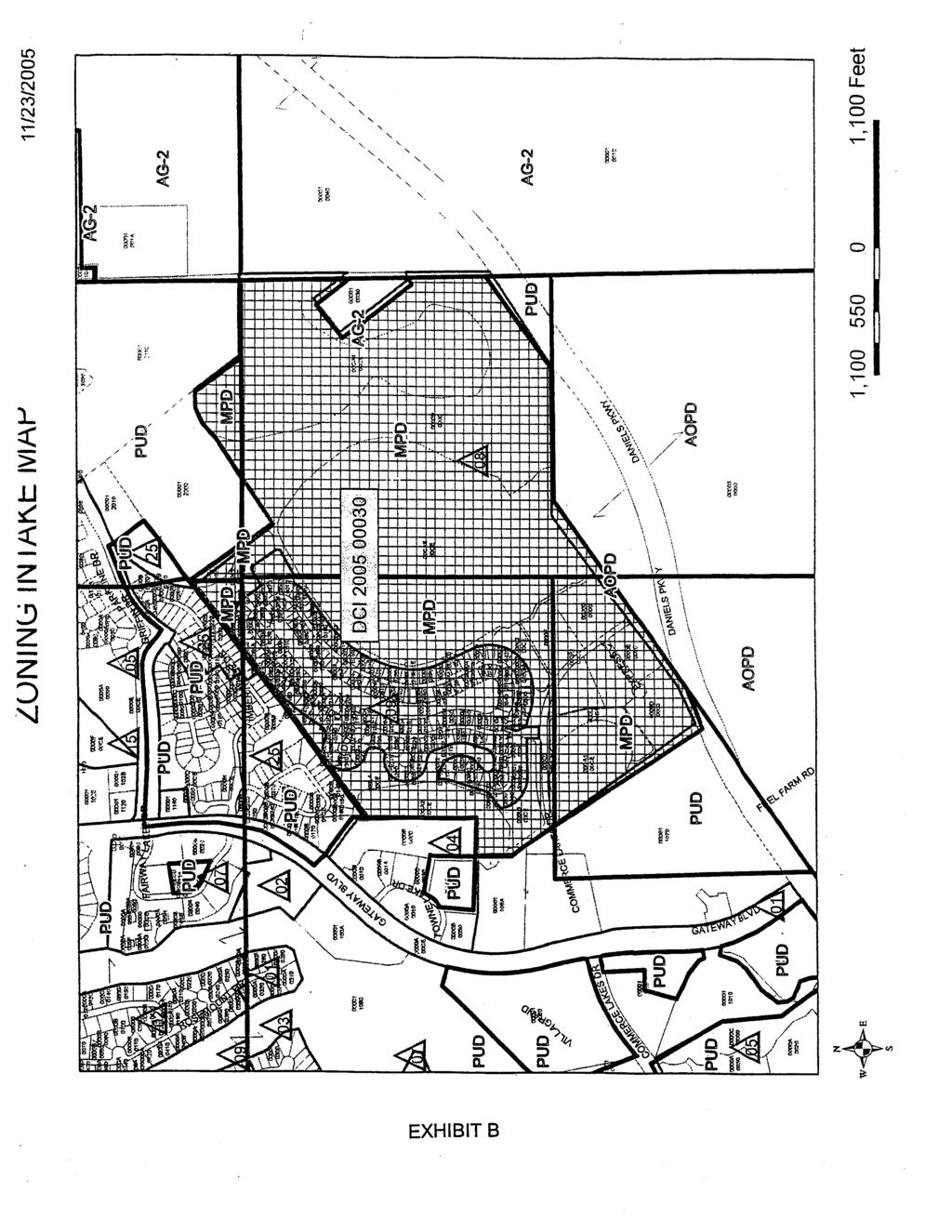
2 FORT MYERS, FLORIDA GATEWAY 54 ACRES MIXED USE PLANNED DEVELOPMENT EXECUTIVE SUMMARY Location Benefits The Gateway Mixed Use PD is located on Daniels Parkway in Fort Myers. The property is a five minute drive to I-75 and ten minutes to Southwest Florida International Airport and Florida Gulf Coast University. The property is ready to build with all utilities available. It provides flexibility as it can be purchased in total or divided. The land is zoned Residential Planned Development which permits up to 495 units on the entire site. The site features frontage on Daniels Parkway, a major arterial roadway. The traffic count is 37,000 two-way AADT. The location has easy access to the airport, major highways, the University, national retailers and entertainment districts. The 456,000 square foot Lee Memorial Hospital is within seven miles of the property. Jet Blue Park is within three minutes of the site. Description Permits Utilities The property is 54 platted acres located in unincorporated Lee County. The land is cleared and 30,000 cubic yards of fill have been placed on the site. Zoning is in place for up to 495 units. The site plan has 315 multifamily units on 12.5 acres, wide single family lots on 16 acres and 88 fourplex units on 10 acres. No ACOE permit is required. All other permits are complete and active. All utilities are available on site. Pricing $11,750,000 bulk 315 MF units $6,225, SF Lots & 88 Fourplex units $5,525,000 Contact Jessica@DevelopmentRealty.org Paul@DevelopmentRealty.org
3
4
5
6
7
8
9
10
11
12
13
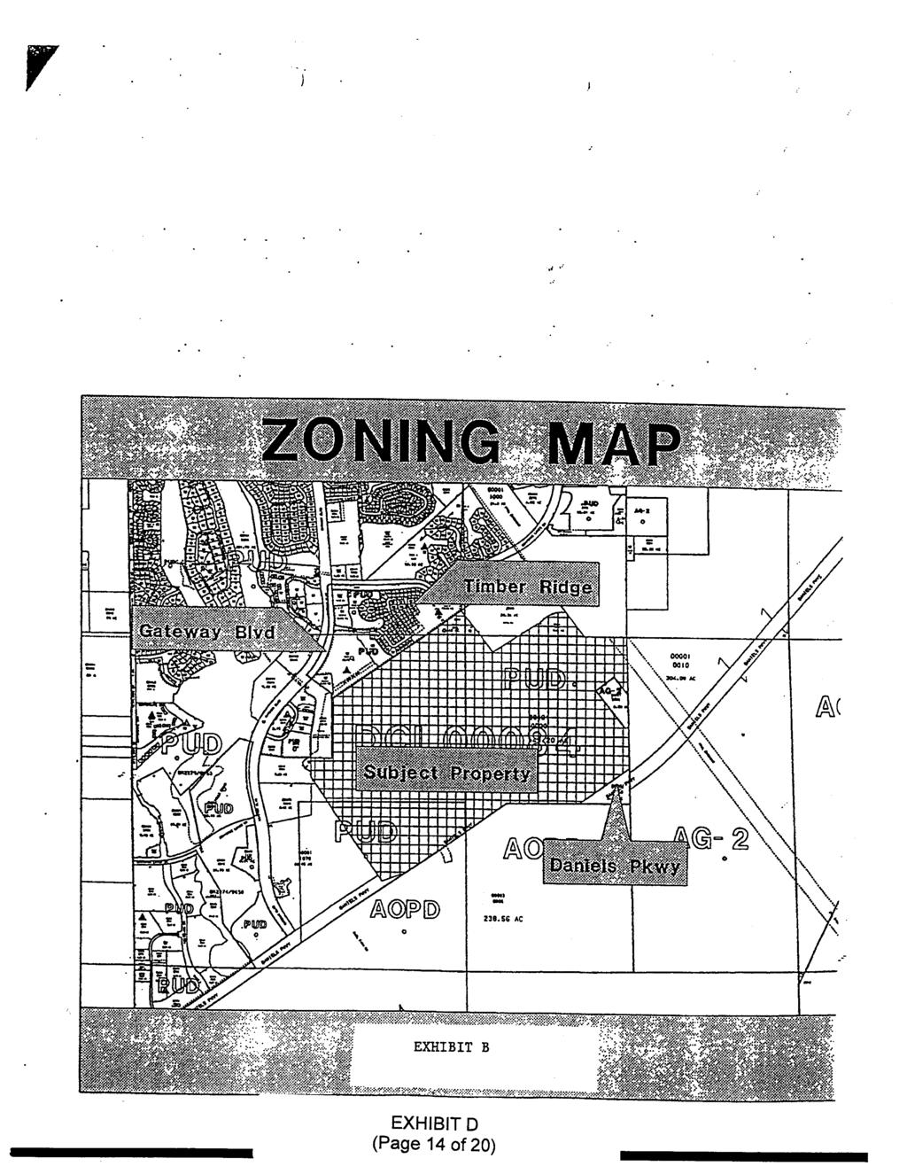
14
15
16
17
18
19
20
21
22
23
24
25
26
27
28
29
30
31
32
33
34
35
36 ADD Lee County eplan ADMINISTRATIVE AMENDMENT (PD) ADD ADMINISTRATIVE AMENDMENT LEE COUNTY,FLORIDA WHEREAS,Worthington Holdings,LLC,filed an application for an administrative amendment to a Mixed Use Planned Development on a project known as Worthington Commerce Park to: 1 - Revise the Master Concept Plan by merging Parcel J with Parcel H2, to be called Parcel J,and Merging Parcel K with a portion of Parcel H1,to be called Parcel K,and the remaining portion of the Parcel H1 to be called H ; and 2- provide amended and new Schedule of Uses and the Development Regulations for the newly formed Tracts; and 3- approve the following additional deviation: Deviation #9: A deviation from the Land Development Code Section b(1 )c,which requires a minimum setback of 30 feet from indigenous plant communities subject to fire to 1 0 feet for Parcel J. on property located on Daniels Parkway,described more particularly as: LEGAL DESCRIPTION: In Section 1 7,Township 45 South,Range 26 East,Lee County,Florida: ATTACHED AS EXHIBIT A WHEREAS,the property was originally rezoned in Resolution number Z (with subsequent amendments in case numbers ADD , ADD , ADD ,ADD ,ADD ,ADD ,ADD , DCI ,and ADD ); and WHEREAS,the subject property is located in the New Community Future Land Use Category as designated by the Lee Plan; and WHEREAS,the Lee County Land Development Code provides for certain administrative changes to planned development master concept plans and planned unit development final development plans; and WHEREAS,Parcels H,J,and K are no longer within the airport noise zone,as they were during the original zoning approval; and WHEREAS,the schedule of uses for Parcel H was amended in 2006 (ADD ) to allow residential uses; and CASE NO. ADD Page 1 of 5
37 ADD Lee County eplan WHEREAS,the subject application and plans have been reviewed by the Lee County Department of Community Development in accordance with applicable regulations for compliance with all terms of the administrative approval procedures; and WHEREAS,it is found that the proposed amendment does not increase density or intensity within the development; does not decrease buffers or open space required by the LDC; does not underutilize public resources or infrastructure; does not reduce total open space,buffering,landscaping or preservation areas; and does not otherwise adversely impact on surrounding land uses. NOW,THEREFORE,IT IS HEREBY DETERMINED that the application for administrative approval for an amendment to Mixed Use Planned Development to: 1 - Revise the Master Concept Plan by merging Parcel J with Parcel H2, to be called Parcel J,and Merging Parcel K with a portion of Parcel H1,to be called Parcel K,and the remaining portion of the Parcel H1 to be called H ; and 2- provide amended and new Schedule of Uses and the Development Regulations for the newly formed Tracts; and 3- approve the following additional deviation: Deviation #9: A deviation from the Land Development Code Section b(1 )c,which requires a minimum setback of 30 feet from indigenous plant communities subject to fire to 1 0 feet for Parcel J. (Approval of this deviation is subject to Condition #3 of this Resolution) is APPROVED subject to the following conditions: 1. The Development must be in compliance with the amended Master Concept Plan, dated 07/15/2015. Master Concept Plan for ADD is hereby APPROVED and adopted. A reduced copy is attached hereto as Exhibit B. 2. The terms and conditions of the original zoning resolutions remain in full force and effect, except for the Schedule of Uses and Development Regulations for Parcels H, J, and K, as amended herein. 3. Prior to the issuance of adevelopment order for Parcel J, asouth Trail Fire Protection and Rescue Service District letter of approval for the reduced setback from the indigenous preserve must be submitted to the Department of Community Development. Should the letter of approval contain any conditions, the development order plans must depict said conditions on the site plan. CASE NO. ADD Page 2 of 5
38 ADD Lee County eplan 4. Prior to any trimming or removal of indigenous plant material from the limits of the preserve, avegetation Removal Permit must be issued. 5. Prior to the issuance of avegetation Removal Permit, the limits of the indigenous preservation areaand the ten foot setback from the preserve limits must be field staked and field inspected by the Development Services Environmental Review staff. 6. Prior to the issuance of abuilding permit for multi-family units in Parcel J, the building plans must depict all conditions required by the South Trail Fire Protection and Rescue Service District. 7. If it is determined that inaccurate or misleading information was provided to the County or if this decision does not comply with the LDC when rendered, then, at any time, the Director may issue amodified decision that complies with the Code or revoke the decision. If the approval is revoked, the applicant may acquire the necessary approvals by filing an application for public hearing in accordance with Chapter The Schedule of Uses for Parcels H, J, and K are amended as follows: Parcel "H": Accessory Uses and Structures Administrative Offices Dwelling Units: Duplex Single-family Townhouse Multi-family building, low rise Zero Lot Line Entrance Gates Essential Services Essential Services Facilities, Group I Fences, Walls Home Occupation Model Homes, Model Units, Model Display Center (limited to residential uses within the Worthington Commerce Park MPD) Parks, Private, playfields and community owned open space Real Estate Sales Office (limited to residential uses within the Worthington Commerce Park MPD) Recreational Facilities, Personal, private On-Site Signs in accordance with LDC Section 30 Temporary Uses (construction trailer/sales trailer) CASE NO. ADD Page 3 of 5
39 ADD Lee County eplan Parcels "J and K": Accessory Uses and Structures Administrative Offices Assisted Living Facility (LDC Sec , Et Seq.) Dwelling Units: Townhouse Multi-family building Zero Lot Line Entrance Gates Essential Services Essential Services Facilities, Group I Fences, Walls Home Occupation Independent Living Facility (LDC Sec , Et Seq.) Model Homes, Model Units, Model Display Center (limited to residential uses within the Worthington Commerce Park MPD) Parks, Private, playfields and community owned open space Real Estate Sales Office (limited to residential uses within the Worthington Commerce Park MPD) Recreational Facilities, Personal, private On-Site Signs in accordance with LDC Section 30 Temporary Uses (construction trailer/sales trailer) 9. The following Development Standards are applicable to Parcels H, J, and K Parcel H - Single Family Min. Lot Size: 4600 SF Min. Lot Width: 40 Feet Min. Lot Depth: 115 Feet Min. Street Setback: 20 Feet Min. Side Setback: 5 Feet Min. Rear Setback: 10 Feet Min Accessory Rear Setback: 5 Feet Min. Lake Setback: 25 Feet Min. Accessory Lake Setback: 20 Feet Maximum Lot Coverage: 60 Percent Development Standards listed in Resolutions ADD and Z are applicable to Townhouse, Zero Lot Line and Multiple-Family projects within the Parcel H Parcel J and K - Townhouses Min. Lot Size: 1800 SF Min. Lot Width: 18 Feet Min. Lot Depth: 90 Feet CASE NO. ADD Page 4 of 5
40 ADD Lee County eplan Min. Street Setback: 20 Feet Min. Side Setback: 0 Feet (Interior Lots), 5 Feet (End Lots) Min. Rear Setback: 10 Feet Min. Rear Accessory Setback: 5 Feet Min. Lake Setback: 20 Feet Min. Accessory Lake Setback: 20 Feet Min. Preserve Setback: 20 Feet Maximum Building Height: 35 Feet Maximum Lot Coverage: 60% Parcel J Multi-Family Min. Lot Size: 7400 SF Min. Lot Width: 78 Feet Min. Lot Depth: 95 Feet Min. Street Setback: 20 Feet Min. Side Setback: 5 Feet Min. Rear Setback: 10 Feet Min. Rear Accessory Setback: 5 Feet Min. Lake Setback: 20 Feet Min. Accessory Lake Setback: 20 Feet Min. Preserve Setback: 10 Feet (Subject to condition #3 of this Resolution) Maximum Building Height: 35 Feet Maximum Lot Coverage: 60% Parcel K Multi-Family Min. Lot Size: 7400 SF Min. Lot Width: 78 Feet Min. Lot Depth: 95 Feet Min. Street Setback: 20 Feet (25 Feet from Daniels Pkwy) Min. Side Setback: 5 Feet Min Rear Setback: 20 Feet Min. Lake Setback: 25 Feet Min Building Separation: 20 Feet Maximum Building Height: 60 Feet Maximum Coverage: 60 Percent Duly passed, adopted, and electronically signed on 7/22/2016 by Pam Houck, Zoning Manager Department of Community Development Attachments: Exhibit A Legal Description Exhibit B Master Concept Plan CASE NO. ADD Page 5 of 5
41 ADD Lee County eplan EXHIBIT A LEGAL DESCRIPTION TRACT H, WORTHINGTON COMMERCE PARK, A SUBDIVISION, LOCATED IN SECTION 17, TOWNSHIP 45 SOUTH, RANGE 26 EAST, AS DESCRIBED IN PLAT BOOK 76 PAGE 74-79, OF THE PUBLIC RECORDS OF LEE COUNTY, FLORIDA. APPROVED ADD Chick Jakacki, Planner Lee Co Division of Zoning 2/17/2016 STRAP NUMBER H.0000
42 ADD Lee County eplan EXHIBIT "B"
) LAND USE CONVERSION TABLE CURRENT LAND USE RETAIL OFFICE PROPOSED LAND USE LIGHT INDUSTRIAL LIGHT INDUSTRIAL INTENSITY CONVERSION 4.15 2.")
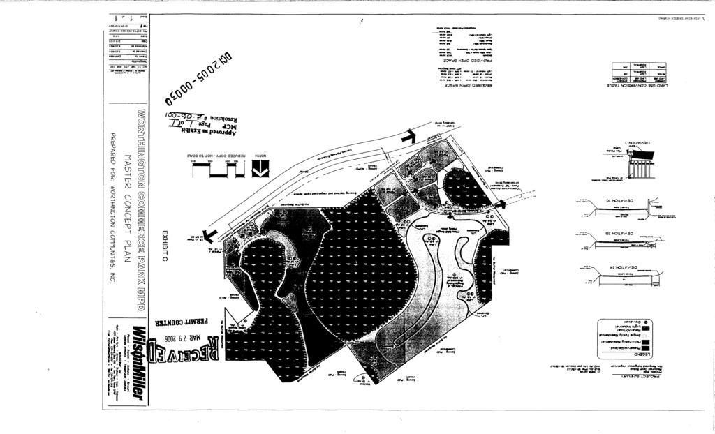
43 PROJECT SUMMARY PROJECT SIZE AC +/- REQUIRED OPEN SPACE 95.0 AC (PER SECTION (a)) MIN REQUIRED INDIGENOUS VEGETATION AC (AS PER SECTION (b)) LAND USE CONVERSION TABLE CURRENT LAND USE RETAIL OFFICE PROPOSED LAND USE LIGHT INDUSTRIAL LIGHT INDUSTRIAL INTENSITY CONVERSION LEGEND PRESERVE MULTI-FAMILY RESIDENTIAL SINGLE FAMILY RESIDENTIAL RETAIL/OFFICE/LIGHT INDUSTRIAL # DEVIATION DEVIATION LIST 1. Deviation 1 Withdrawn 2. Deviation 2 seeks relief from the LDC (e)(1)(a) requirement for minimum setbacks for excavations for water retention from street right of ways to allow reduced lake setbacks. This deviation is APPROVED, SUBJECT TO Condition 7 as follows: A. Setbacks for excavations to be measured from the edge of pavement or back of curb to the edge of the water control elevation. B. A minimum 25-foot setback from the water control elevation of the lake to the back of curb from local streets; and C. A minimum zero-foot setback from the back of curb to the water control elevation of the lake where adequate elements for the protection of wayward vehicles is provided. 3. Deviation 3 seeks relief from the LDC (e)(4) requirement that excavation bank slopes be no greater than 4:1 to allow the project to conform the South Florida Water Management District (SFWMD) permit. This deviation is APPROVED, SUBJECT TO Condition Deviation 4 seeks relief from the LDC and requirement that properties exhibiting soils, hydrology, and vegetation characteristic of freshwater inundation be subject to additional regulations; to allow impacts and mitigation of wetlands as approved by the ACOE and SFWMD. This deviation is APPROVED, SUBJECT TO Condition Deviation 5 Withdrawn 6. Deviation 6 Withdrawn 7. Deviation 7 seeks relief from the LDC (c)(3)b requirement for a 10-foot setback from nonseawalled artificial bodies of water; to eliminate the setback requirement for recreational/amenity structures, allowing these structures to be places at the lake s control elevation. This deviation is APPROVED, SUBJECT to Condition 9 8. Deviation 8 Withdrawn 9. Deviation 9 seeks relief from LDC requirement for a 25 foot setback from conservation area limits to allow multi-family buildings up to 10 feet from the preserve limits when the FLUCCS is upland. This deviation would require that limits of the conservation area are to be staked prior to construction to protect the existing habitat. community engineering services, inc.
44
45
46
47
48
49
50
51
52
53
54
55
56
57
58
59
60
61
62
63
64
65
66
67
68
69
70
71
72
73
74
75
76
77
78
79
ADMINISTRATIVE AMENDMENT LEE COUNTY,FLORIDA
 ADMINISTRATIVE AMENDMENT (PD) ADD201 5-00050 ADMINISTRATIVE AMENDMENT LEE COUNTY,FLORIDA WHEREAS,Omega Communities,LLC filed an application for an administrative amendment to Daniels Crossing for a project
ADMINISTRATIVE AMENDMENT LEE COUNTY, FLORIDA
 ADMINISTRATIVE AMENDMENT (PD) ADD201 4-00040 ADMINISTRATIVE AMENDMENT LEE COUNTY, FLORIDA WHEREAS, Griffin Bonita Springs Properties, LLC filed an application for an administrative amendment to a Commercial
CITY OF BONITA SPRINGS ZONING ORDINANCE NO
 CITY OF BONITA SPRINGS ZONING ORDINANCE NO. 01-28 A ZONING ORDINANCE OF THE CITY OF BONITA SPRINGS, FLORIDA; APPROVING A REQUEST BY LONG BAY PARTNERS, LLC, IN REFERENCE TO MEDITERRA RPD TO REZONE 41.1+
CITY OF BONITA SPRINGS ZONING ORDINANCE NO
 CITY OF BONITA SPRINGS ZONING ORDINANCE NO. 06-05 A ZONING ORDINANCE OF THE CITY OF BONITA SPRINGS, FLORIDA; APPROVING A REQUEST BY NAPITA HOLDINGS, LLC IN REFERENCE TO BONITA ROAD LOCKUP CPD; TO REZONE
CITY OF BONITA SPRINGS ZONING ORDINANCE NO
 CITY OF BONITA SPRINGS ZONING ORDINANCE NO. 05-11 A ZONING ORDINANCE OF THE CITY OF BONITA SPRINGS, FLORIDA; APPROVING A REQUEST BY ROCKPOINT/RONTO NAPLES, LLC IN REFERENCE TO EAST BONITA ACTIVE ADULT
TABLE (A): TABLE OF DIMENSIONAL STANDARDS IN THE RESIDENTIAL ZONE DISTRICTS REQUIRED YARDS [4], [5] SIDE YARD (FT) REAR YARD (FT) R-1 DISTRICT
![TABLE (A): TABLE OF DIMENSIONAL STANDARDS IN THE RESIDENTIAL ZONE DISTRICTS REQUIRED YARDS [4], [5] SIDE YARD (FT) REAR YARD (FT) R-1 DISTRICT](/thumbs/85/92855381.jpg "TABLE (A): TABLE OF DIMENSIONAL STANDARDS IN THE RESIDENTIAL ZONE DISTRICTS REQUIRED YARDS [4], [5] SIDE YARD (FT) REAR YARD (FT) R-1 DISTRICT") ARTICLE : DENSITY, INTENSITY, & DIMENSIONAL STANDARDS Section -100: General Provisions TABLE 17--100(A): TABLE OF DIMENSIONAL STANDARDS IN THE RESIDENTIAL ZONE DISTRICTS R-1 DISTRICT AREA (SQ FT)[3] WIDTH
ARTICLE : DENSITY, INTENSITY, & DIMENSIONAL STANDARDS Section -100: General Provisions TABLE 17--100(A): TABLE OF DIMENSIONAL STANDARDS IN THE RESIDENTIAL ZONE DISTRICTS R-1 DISTRICT AREA (SQ FT)[3] WIDTH
EXHIBIT A FOR HAMILTON PLACE RPUD
 EXHIBIT A Regulations for development of the Hamilton Place RPUD shall be in accordance with the contents of this RPUD Document and applicable sections of the LDC and Growth Management Plan (GMP) in effect
CITY OF BONITA SPRINGS ZONING ORDINANCE NO
 CITY OF BONITA SPRINGS ZONING ORDINANCE NO. 01-12 A ZONING ORDINANCE OF THE CITY OF BONITA SPRINGS, FLORIDA; APPROVING A REQUEST BY BONITA SPRINGS YMCA FOR REZONING FROM AGRICULTURE (AG-2) AND RESIDENTIAL
CITY OF BONITA SPRINGS ZONING ORDINANCE NO
 CITY OF BONITA SPRINGS ZONING ORDINANCE NO. 07-17 A ZONING ORDINANCE OF THE CITY OF BONITA SPRINGS, FLORIDA; APPROVING A REQUEST BY MR. JAMES INK IN REFERENCE TO DORSET HARBOR TO REZONE FROM AGRICULTURAL
CITY OF BONITA SPRINGS ZONING ORDINANCE NO
 CITY OF BONITA SPRINGS ZONING ORDINANCE NO. 01-02 A ZONING ORDINANCE OF THE CITY OF BONITA SPRINGS, FLORIDA; APPROVING A REQUEST BY BONITA GATEWAY DEVELOPMENT CO., TO REZONE FROM COMMERCIAL PLANNED DEVELOPMENT
PINE RIDGE COMMONS PUD AMEND ORDINANCE NUMBER 99-94
 PINE RIDGE COMMONS PUD AMEND ORDINANCE NUMBER 99-94 Title page of the Planned Unit Development Document, previously attached as Exhibit A to the PUD document of Ordinance Number 99-94, the Pine Ridge commons
LEGAL DESCRIPTION: In Section 31, Township 46 South, Range 25 East, Lee County, Florida:
 ADMINISTRATIVE AMENDMENT (FPA) ADD2006-00043 ADMINISTRATIVE LEE COUNTY, AMENDMENT FLORIDA WHEREAS, West Bay Development filed an application for an amended Final Plan Approval to a Residential Planned
ARTICLE 759. PD 759. PD 759 was established by Ordinance No , passed by the Dallas City Council on June 27, (Ord. Nos.
 ARTICLE 759. PD 759. SEC. 51P-759.101. LEGISLATIVE HISTORY. PD 759 was established by Ordinance No. 26871, passed by the Dallas City Council on June 27, 2007. (Ord. Nos. 26871; 29304) SEC. 51P-759.102.
CITY OF BONITA SPRINGS ZONING ORDINANCE NO A ZONING ORDINANCE OF THE CITY OF BONITA SPRINGS, FLORIDA;
 PARKLANDS; AMENDING CONDITION FOUR AND ADDING A DEVIATION; AMENDING ZONING ORDINANCE NO. 03-03, PALMIRA RPD/CPD F/K/A A ZONING ORDINANCE OF THE CITY OF BONITA SPRINGS, FLORIDA; u:\city Attorney\Zoning
ORANGE BLOSSOM GARDENS PLANNED UNIT DEVELOPMENT PREPARED BY: COASTAL ENGINEERING CONSULTANTS, INC.
 ORANGE BLOSSOM GARDENS A PLANNED UNIT DEVELOPMENT PREPARED BY: COASTAL ENGINEERING CONSULTANTS, INC. REVISED OCTOBER 19, 1992 BY THE COLLIER COUNTY LONG RANGE PLANNING DEPARTMENT REVISED DECEMBER, 2008
ARTICLE 67. PD 67. Unless otherwise stated, the definitions and interpretations in Chapter 51 apply to this
 ARTICLE 67. PD 67. SEC. 51P-67.101. LEGISLATIVE HISTORY. PD 67 was established by Ordinance No. 15189, passed by the Dallas City Council on May 24, 1976. Ordinance No. 15189 amended Ordinance No. 10962,
1. Multi-family dwellings, including town homes, apartments, or condominiums.
 Sec. 4-6.67 Planned Unit Development (PUD-M). a. Definition. A planned multi-family zoning district of three acres or more, consisting of townhouses, apartments, condominiums, single-family detached, single-family
Cover Letter with Narrative Statement
 Cover Letter with Narrative Statement March 31, 2017 rev July 27, 2017 RE: Rushton Pointe Residential Planned Unit Development Application for Public Hearing for RPUD Rezone PL2015 000 0306 Mr. Eric Johnson,
Exhibit "A" have applied for a re-zoning and re-classification of that property from OPEN RURAL (OR) to that of a PLANNED UNIT DEVELOPMENT (PUD); and
 to that of a PLANNED UNIT DEVELOPMENT (PUD); and") I NSTR # 200632845 OR BK 61439 PGS 0728-0750 RECORDED 06/24/2066 12:25:50 PR JOHN Q. CRAWFOKD CLERK OF CIRCUIT COURT NASSAU COUNTY, FLORIDA RECORDING FEES 1.37.80 ORDINANCE NO. 2006-65 AN ORDINANCE AMENDING
I NSTR # 200632845 OR BK 61439 PGS 0728-0750 RECORDED 06/24/2066 12:25:50 PR JOHN Q. CRAWFOKD CLERK OF CIRCUIT COURT NASSAU COUNTY, FLORIDA RECORDING FEES 1.37.80 ORDINANCE NO. 2006-65 AN ORDINANCE AMENDING
Vacant Corner Lot in Golden Gate
 FOR SALE $79,000 Property Details PRICE $79,000 PARCEL ID 37-38-41-007-032-00070-7 LAND SIZE 11,000 sf Great corner vacant lot in the Golden Gate area of Stuart. Site is comprised of 4 lots with the with
CITY OF BONITA SPRINGS ZONING ORDINANCE NO
 CITY OF BONITA SPRINGS ZONING ORDINANCE NO. 04-16 A ZONING ORDINANCE OF THE CITY OF BONITA SPRINGS, FLORIDA; APPROVING A REQUEST BY CUSSON S CPD TO REZONE FROM AGRICULTURE (AG-2) AND COMMERCIAL PLANNED
City of Dade City, Florida Land Development Regulations ARTICLE 5: DENSITY, INTENSITY & DIMENSIONAL STANDARDS
 City of Dade City, Florida Land Development Regulations ARTICLE 5: DENSITY, INTENSITY & DIMENSIONAL STANDARDS ADOPTED AUGUST 12, 2014 ARTICLE 5: DENSITY, INTENSITY & DIMENSIONAL STANDARDS SECTION 5.1 DIMENSIONAL
Permitted uses. Adult congregate living facility. Ambulance service. Animal clinics (outpatient care only and no overnight boarding)
") B-3, HIGHWAY SERVICE BUSINESS DISTRICT Intent. The B-3, Highway Service Business District is intended for application along highways carrying large volumes of traffic where establishments may locate to
B-3, HIGHWAY SERVICE BUSINESS DISTRICT Intent. The B-3, Highway Service Business District is intended for application along highways carrying large volumes of traffic where establishments may locate to
1. Cuyler-Brownsville planned neighborhood conservation (P-N-C) districtphase I (section ). (2) Single-family semiattached dwellings;
 districtphase I (section ). (2) Single-family semiattached dwellings;") Sec. 8-3035. Planned unit development multifamily (PUD-M). A. Purpose. The PUD-M district is intended to allow a variety of residential development including single-family residential, two-family residential,
Sec. 8-3035. Planned unit development multifamily (PUD-M). A. Purpose. The PUD-M district is intended to allow a variety of residential development including single-family residential, two-family residential,
FREQUENTLY USED PLANNING & ZONING TERMS
 City Of Mustang FREQUENTLY USED PLANNING & ZONING TERMS Abut: Having property lines, street lines, or zoning district lines in common. Accessory Structure: A structure of secondary importance or function
PINE RIDGE COMMONS PUD AMEND ORDINANCE NUMBER 99-94
 PINE RIDGE COMMONS PUD AMEND ORDINANCE NUMBER 99-94 Title page of the Planned Unit Development Document, previously attached as Exhibit A to the PUD document of Ordinance Number 99-94, the Pine Ridge commons
Fort Pierce Medical Park Building
 FOR SALE $1,500,000 Fort Pierce Medical Park Building OWNER FINANCING AVAILABLE Property Details Fort Pierce Medical Park Building PRICE $1,500,000 BUILDING SIZE 9,000 SF BUILDING TYPE Medical BUILDING
Limited Review Development Order Application
 Limited Review Development Order Application Community Development Department 9220 Bonita Beach Rd, Suite 111 Bonita Springs, FL 3413 Phone: 239 444 610 Fax: 239 444 6140 Applicant s Name: Phone # E-mail:
EXHIBIT D. Planned Unit Development Written Description April 13, 2016 Rouen Cove Phase II PUD
 1 EXHIBIT D Planned Unit Development Written Description April 13, 2016 Rouen Cove Phase II PUD Development # 8986.001 Developer: Curtis L. Hart Hart Resources LLC 8051 Tara Lane Jacksonville, Florida
ORDINANCE NO. ABINGTON TOWNSHIP MONTGOMERY COUNTY, PENNSYLVANIA
 REVISED 11.3.2018 ORDINANCE NO. ABINGTON TOWNSHIP MONTGOMERY COUNTY, PENNSYLVANIA AN ORDINANCE OF ABINGTON TOWNSHIP, MONTGOMERY COUNTY, PENNSYLVANIA, AMENDING THE ABINGTON TOWNSHIP ZONING ORDINANCE OF
Industrial Warehouse Space
 FOR LEASE $6.50/psf Property Details PRICE $6.50/sf PARCEL ID 2410-344-0003-000-3 BUILDING SIZE 8,190 sf A great opportunity to lease an 8,190 sf industrial warehouse property located on the corner of
Administrative Action Request
 Administrative Action Request Community Development Dept. 9220 Bonita Beach Road, Ste. 111 Bonita Springs, FL 34135 (239) 444-6150 permitting@cityofbonitaspringscd.org Type of Request (please check one):
The following regulations shall apply in the R-E District:
 "R-E" RESIDENTIAL ESTATE DISTRICT (8/06) The following regulations shall apply in the R-E District: 1. Uses Permitted: The following uses are permitted. A Zoning Certificate may be required as provided
$3,750,000. Dixie Highway & Green River Pkwy, Stuart, FL. Offered at:
 Dixie Highway & Green River Pkwy, Stuart, FL Palm City Roosevelt Bridge St. Lucie River ighway Gr ee ie H NE Dix ker E Ba 36 N nr ive rp kw y Road th Presented by: Nikolaus M. Schroth, CCIM Associate Broker/Vice
DIVISION 7. R-6 AND R-6A RESIDENTIAL ZONES* The purpose of the R-6 residential zone is:
 Date of Draft: March 6, 2015 DIVISION 7. R-6 AND R-6A RESIDENTIAL ZONES* Sec. 14-135. Purpose. The purpose of the R-6 residential zone is: (a) To set aside areas on the peninsula for housing characterized
ARTICLE 5. R-6 Residential- Duplex, Single Family Detached and Townhouse District
 ARTICLE 5 R-6 Residential- Duplex, Single Family Detached and Townhouse District 5.1. Conformity Subject to Article 11 of this Ordinance (Non-conforming Situations), no person may use, occupy, or sell
+/ AC of Land (4 Lots)
") FOR SALE $599,000 Property Details PRICE $599,000 (2979) 340-705-0017-000-5 (2971) 3420-705-0018-000-2 (836) 3420-705-0039-000-5 PARCEL ID(S) (834) 3420-705-0040-000-5 LAND SIZE 51,196 SF (Total) ACREAGE
FOR SALE $599,000 Property Details PRICE $599,000 (2979) 340-705-0017-000-5 (2971) 3420-705-0018-000-2 (836) 3420-705-0039-000-5 PARCEL ID(S) (834) 3420-705-0040-000-5 LAND SIZE 51,196 SF (Total) ACREAGE
Planning Department Oconee County, Georgia
 Planning Department Oconee County, Georgia STAFF REPORT REZONE CASE #: 6985 DATE: October 31, 2016 STAFF REPORT BY: Andrew C. Stern, Planner APPLICANT NAME: Williams & Associates, Land Planners PC PROPERTY
RESOLUTION NO. B. The proposed amendment would not be detrimental to the public interest, health, safety, convenience, or welfare of the City; and
 RESOLUTION NO. RESOLUTION OF THE PLANNING COMMISSION OF THE CITY OF SANTA ROSA RECOMMENDING TO CITY COUNCIL REZONING TO MODIFY THE EXISTING POLICY STATEMENT AND ADOPT THE BAY VILLAGE HOMES DEVELOPMENT
Marion County Board of County Commissioners
 Marion County Board of County Commissioners Date: 12/29/2015 P&Z: 12/28/2015 BCC: 1/12/2016 Item Number 160113Z Type of Application Rezoning Request From: A-1 (General Agriculture) To: PUD (Planned Unit
Storefront Lease Space
 FOR LEASE $1,550.00/mo. Property Details LEASE RATE $1,550.00 /mo. SPACE AVAILABLE 1,750 sf BUILDING TYPE Strip Center ACREAGE 0.39 AC FRONTAGE 117.4 Great opportunity to lease this high exposure end unit
CCC XXX Rural Neighborhood Conservation (NC)
") CCC 33.10.XXX Rural Neighborhood Conservation (NC) Purpose: Maintain low density rural residential areas and associated uses commonly found in rural areas consistent with the local character of the distinctive
CCC 33.10.XXX Rural Neighborhood Conservation (NC) Purpose: Maintain low density rural residential areas and associated uses commonly found in rural areas consistent with the local character of the distinctive
Residential Project Convenience Facilities
 Standards for Specific Land Uses 35.42.220 E. Findings. The review authority shall approve a Land Use Permit in compliance with Subsection 35.82.110.E (Findings required for approval) or a Conditional
PD No. 15 Authorized Hearing
 PD No. 15 Authorized Hearing Community Meeting April 26, 2018 6:00 P.M. Park Cities Baptist Church Fellowship Hall 3933 Northwest Parkway Presented by: Sustainable Development and Construction PD No. 15
SECTION CLASSIFICATION OF ZONES For the purpose of this Code the following primary land use zoning districts are hereby established:
 ARTICLE 4 ZONING DISTRICTS SECTION 4.010 CLASSIFICATION OF ZONES For the purpose of this Code the following primary land use zoning districts are hereby established: Primary Zones Abbreviated Designation
Staff Report PLANNED DEVELOPMENT. Salt Lake City Planning Commission. From: Lauren Parisi, Associate Planner; Date: December 14, 2016
 Staff Report PLANNING DIVISION COMMUNITY & NEIGHBORHOODS To: Salt Lake City Planning Commission From: Lauren Parisi, Associate Planner; 801-535-7932 Date: December 14, 2016 Re: 1611 South 1600 East PLANNED
O-I (Office-Institutional) and AG-1(Agricultural)
 and AG-1(Agricultural)") PROPERTY INFORMATION ADDRESS 3503 and 3505 Bethany Bend DISTRICT, LAND LOTS 2/1 973 and 974 OVERLAY DISTRICT State Route 9 PETITION NUMBERS EXISTING ZONING O-I (Office-Institutional) and AG-1(Agricultural)
PROPERTY INFORMATION ADDRESS 3503 and 3505 Bethany Bend DISTRICT, LAND LOTS 2/1 973 and 974 OVERLAY DISTRICT State Route 9 PETITION NUMBERS EXISTING ZONING O-I (Office-Institutional) and AG-1(Agricultural)
31, Township 29 South, Range 25 East, Polk County, Florida, as depicted by the Land Use Plan attached
 ORDINANCE NO. 2013-04 AN ORDINANCE AMENDING THE ZONING MAP OF THE CITY OF BARTOW, FLORIDA, REZONING APPROXIMATELY 2. 2 ACRES OF LAND OWNED BY BALA3I OF POLK COUNTY, LLC AND LOCATED IN SECTION 31, TOWNSHIP
ORDINANCE NO AN ORDINANCE To Be Entitled:
 3808 AN ORDINANCE To Be Entitled: AN ORDINANCE OF THE CITY COUNCIL OF THE CITY OF FORT MYERS, FLORIDA, REZONING FROM COMMERCIAL GENERAL TO PLANNED UNIT DEVELOPMENT AND APPROVING THE DEVELOPMENT PLAN FOR
Single Family Residential
 Housing Development Tools Single Family Residential Single Family Residence 1 Current Accessory Apartment Ordinance Single Family Residence 600 Square Foot Accessory Apartment (Net Floor Area) Twice Minimum
In order to permit maximum applicability of the PUD District, PUD-1 and PUD-2 Districts are hereby created.
 ARTICLE III. PUD ned Unit Development Overlay District 205-128. Purpose. The PUD ned Unit Development Overlay District is intended to provide flexibility in the design of planned projects; to encourage
Multi-family dwellings (including assisted living facilities), Public buildings, facility or land; and,
, Public buildings, facility or land; and,") 607. General Residential District (GR) Intent. It is the intent of this section that the General Residential District be established for medium-to-high density residential purposes. These areas need to
607. General Residential District (GR) Intent. It is the intent of this section that the General Residential District be established for medium-to-high density residential purposes. These areas need to
TOWNSHIP OF SOLON COUNTY OF KENT, MICHIGAN. Members: Robert Ellick, Fred Gunnell, Mark Hoskins, Mary Lou Poulsen
 As recommended by Planning Commission at its December 27, 2017 meeting TOWNSHIP OF SOLON COUNTY OF KENT, MICHIGAN At a regular meeting of the Township Board of the Township of Solon, Kent County, Michigan,
ACCESSORY DWELLING UNITS IN THE SOUTHEAST SECTOR
 February 19, 2019 Staff Report to the Municipal Planning Board LDC2018-10020 Item #11 S U M M A R Y Applicant The City of Orlando ACCESSORY DWELLING UNITS IN THE SOUTHEAST SECTOR Applicant s Request Update
ARTICLE 50. PD 50. Unless otherwise stated, the definitions and interpretations in Chapter 51 apply to this
 ARTICLE 50. PD 50. SEC. 51P-50.101. LEGISLATIVE HISTORY. PD 50 was established by Ordinance No. 13428, passed by the Dallas City Council on November 8, 1971. Ordinance No. 13428 amended Ordinance No. 10962,
BLACKFIN SHOPPES GMP ZON I TEM #3. Staff Report to the Municipal Planning Board July 19, Location Map S UMMARY.
 Staff Report to the Municipal Planning Board July 19, 2016 GMP2015-00054 ZON2015-00057 I TEM #3 BLACKFIN SHOPPES Location Map Subject Site S UMMARY Owners Edgar Yates Colleen Yates, Clifton Ackerman &
May 12, Chapter RH HILLSIDE RESIDENTIAL ZONES REGULATIONS Sections:
 May 12, 2017 Chapter 17.13 RH HILLSIDE RESIDENTIAL ZONES REGULATIONS Sections: 17.13.010 Title, intent, and description. 17.13.020 Required design review process. 17.13.030 Permitted and conditionally
CITY OF LABELLE ORDINANCE BROWARD AVE LLC PLANNED UNIT DEVELOPMENT REZONE
 CITY OF LABELLE ORDINANCE 2019-04 BROWARD AVE LLC PLANNED UNIT DEVELOPMENT REZONE AN ORDINANCE OF THE CITY OF LABELLE, FLORIDA, AMENDING THE CITY OF LABELLE ZONING MAP FOR PROPERTY LOCATED SOUTH OF BROWARD
LAKE NONA PARCEL 10 & 11
 October 17, 2017 Staff Report to the Municipal Planning Board CASE #DRI2017-10003 GMP2017-10012 GMP2017-10013 ZON2017-10005 Item #2 LAKE NONA PARCEL 10 & 11 Location Map Subject Site SUMMARY Owner James
Prime Development Land
 FOR SALE $500,000 Property Details Two parcels of land located on prime location of Port St. Lucie. PRICE $500,000 3420-585-1269-000-7 PARCEL ID 3420-585-1268-000-0 ACREAGE 0.23 AC (0.46 AC) Permitted
ORDINANCE NO. ABINGTON TOWNSHIP MONTGOMERY COUNTY, PENNSYLVANIA
 REVISED 8.15.18 ORDINANCE NO. ABINGTON TOWNSHIP MONTGOMERY COUNTY, PENNSYLVANIA AN ORDINANCE OF ABINGTON TOWNSHIP, MONTGOMERY COUNTY, PENNSYLVANIA, AMENDING THE ABINGTON TOWNSHIP ZONING ORDINANCE OF 2017,
PRIMUS TRACT MOUNT PLEASANT, SOUTH CAROLINA
 DEVELOPMENT GUIDELINES FOR PRIMUS TRACT MOUNT PLEASANT, SOUTH CAROLINA Date February 18, 2015 PLANNING COMMISSION SUBMITTAL Owner/Developer: American Star Development SC, LLC P.O. Box 211 Sullivans Island,
ARTICLE FIVE FINAL DRAFT
 ARTICLE FIVE 021218 FINAL DRAFT Sec. 503.6 Open Space Preservation Option Open Space Preservation Option Open Space Preservation developments may be approved in the AR, R-1, R-2 and R-3 zoning districts,
** If your lot does not meet the requirements above, please read Sec below
 Sec. 13-1-60 Zoning District Dimensional Requirements. For the Zoning Dept To Issue a Land Use Permit The Following Dimensions are Required. Minimum Side and Rear Yards s Lakes Classification Minimum Class
ORDINANCE NO LOCATED AT ROAD AND PROPERPT SOUTH TO 1-70 BETWEEN 23 ROAD AND BOOKCLIFF RANCHES SUBDIVISION
 RECEPTIONS 2859566 10/29/18 1:52:59 PM,1 of 11 Recording: $63.00, Sheila Reiner, Mesa County, CO. CITY OF GRAND JUNCTION, COLORADO CUERKAND RECORDER ORDINANCE NO. 4822 AN ORDINANCE AMENDING THE COMPREHENSIVE
AGENDA ITEM SUMMARY GLADES COUNTY BOARD OF COUNTY COMMISSIONERS
 AGENDA ITEM SUMMARY GLADES COUNTY BOARD OF COUNTY COMMISSIONERS SUBJECT: Case Number COMP17-01, Legend Moto LLC This is a Legislative Hearing. DEPARTMENT REQUEST: The Community Development Department requests
CITY OF FATE, TEXAS UNIFIED DEVELOPMENT ORDINANCE. Article III Zoning Districts
 CITY OF FATE, TEXAS UNIFIED DEVELOPMENT ORDINANCE Article III Zoning Districts 3.1. General to all Zoning Districts and Zoning Map 3.1.1. Zoning Districts Established This article establishes the zoning
SECTION 848 "R-E" - RECREATIONAL DISTRICT
 SECTION 848 "R-E" - RECREATIONAL DISTRICT The "R-E" District is intended to provide for the proper development of recreational areas of the County of Fresno. All regulations for this District are deemed
6. RESIDENTIAL ZONE REGULATIONS
 6. RESIDENTIAL ZONE REGULATIONS PART 6A PURPOSE OF CHAPTER (1) The purpose of this Chapter is to provide detailed regulations and requirements that are relevant only to residential zones and specific residential
Draft Zoning Changes for the 2nd Planning Board Public Hearing, January 22, 2018.
 Draft Zoning Changes for the 2nd Planning Board Public Hearing, January 22, 2018. No changes were made at the 1st Public Hearing. Proposed wording for the 1 st Public Hearing in red, eliminated text in
4.13 RM7 and RM8 ZONES (DETACHED, SEMI-DETACHED, DUPLEX, TRIPLEX AND HORIZONTAL MULTIPLE DWELLINGS WITH 4 TO 6 DWELLING UNITS)
") 4.13 RM7 and RM8 ZONES (DETACHED, SEMI-DETACHED, DUPLEX, TRIPLEX AND HORIZONTAL MULTIPLE DWELLINGS WITH 4 TO 6 DWELLING UNITS) 4.13.1 RM7 and RM8 Permitted Uses and Zone All buildings and structures shall
4.13 RM7 and RM8 ZONES (DETACHED, SEMI-DETACHED, DUPLEX, TRIPLEX AND HORIZONTAL MULTIPLE DWELLINGS WITH 4 TO 6 DWELLING UNITS) 4.13.1 RM7 and RM8 Permitted Uses and Zone All buildings and structures shall
CONDITIONAL USE PERMIT APPLICATION FOR AN EXCAVATION/BORROW PIT INSTRUCTIONS
 City of Chesapeake Department of Planning Post Office Box 15225 Chesapeake, Virginia 23328-5225 (757) 382-6176 FAX (757) 382-6406 CONDITIONAL USE PERMIT APPLICATION FOR AN EXCAVATION/BORROW PIT INSTRUCTIONS
PLANNED UNIT DEVELOPMENTS
 PLANNED UNIT DEVELOPMENTS SECTION 9.01 DESCRIPTION AND PURPOSE. A. The purpose of a planned unit development (PUD) is to permit greater flexibility in development than is generally possible under standard
Exhibit A-1. Piney Creek Bend Planned Development
 Exhibit A-1 Piney Creek Bend Planned Development A. Purpose and Intent The Piney Creek Bend PD is composed of approximately 90.91 acres, as described in Exhibit D (Field Notes). The development of this
ARTICLE 5.0 SCHEDULE OF REGULATIONS
 ARTICLE 5.0 SCHEDULE OF REGULATIONS Section 5.101 Table of Dimensional Standards by District. Dimensional Standards AG AG with sewer Districts Rural Residential Business Other SF SF with sewer R-1 R-1
ARTICLE 455. PD 455. Bluffview Special Purpose District
 ARTICLE 455. PD 455. Bluffview Special Purpose District SEC. 51P-455.101. LEGISLATIVE HISTORY. PD 455 was established by Ordinance No. 22865, passed by the Dallas City Council on August 28, 1996. Ordinance
DEPARTMENT OF PLANNING AND COMMUNITY DEVELOPMENT STAFF REPORT
 DEPARTMENT OF PLANNING AND COMMUNITY DEVELOPMENT STAFF REPORT PLANNING COMMISSION AGENDA ITEM # 5: Project Name: Star Dance Zoning Map Amendment, ZMA-13-02 Prepared By: Toby Stauffer, AICP City Planner
GWINNETT COUNTY CSO CONSERVATION SUBDIVISION OVERLAY DISTRICT REQUIREMENTS
 GWINNETT COUNTY CSO CONSERVATION SUBDIVISION OVERLAY DISTRICT REQUIREMENTS Section 1316. CSO Conservation Subdivision Overlay District. 1. Purposes. The purposes of this overlay district are as follows:
11 November 13, 2013 Public Hearing
 11 November 13, 2013 Public Hearing APPLICANT:. D/B/A RYAN HOMES PROPERTY OWNER: MUNDEN LAND, LLC STAFF PLANNER: Carolyn A.K. Smith REQUEST: Modification of Conditional Change of Zoning approved by the
Address Southeast Quadrant of U.S. Highway 41 and Sumter Boulevard City. North Port State. FL Zip Code County
 SUBJECT AERIAL LOCATION LAND AREA THREE-YEAR OWNERSHIP HISTORY OF SUBJECT Address Southeast Quadrant of U.S. Highway 41 and Sumter Boulevard City North Port State FL Zip Code 34287 County Sarasota Nearest
PROCEDURE LIST FOR LARGE-SCALE FUTURE LAND USE AMENDMENT
 DEPARTMENT OF COMMUNITY DEVELOPMENT Case # PROCEDURE LIST FOR LARGE-SCALE FUTURE LAND USE AMENDMENT 1. Applicant s portion of request shall be typewritten and signature notarized. a) All forms (Application,
MONTGOMERY COUNTY PLANNING DEPARTMENT THE MARYLAND-NATIONAL CAPITAL PARK AND PLANNING COMMISSION
 MONTGOMERY COUNTY PLANNING DEPARTMENT THE MARYLAND-NATIONAL CAPITAL PARK AND PLANNING COMMISSION MCPB Item No.: Date: 06-21-12 The Plantations, Preliminary Plan -120090240 Benjamin Berbert, Senior Planner,
ARTICLE 14 PLANNED UNIT DEVELOPMENT (PUD) DISTRICT
 DISTRICT") ARTICLE 14 PLANNED UNIT DEVELOPMENT (PUD) DISTRICT Section 14.01 Intent. It is the intent of this Article to allow the use of the planned unit development (PUD) process, as authorized by the Michigan Zoning
ARTICLE 14 PLANNED UNIT DEVELOPMENT (PUD) DISTRICT Section 14.01 Intent. It is the intent of this Article to allow the use of the planned unit development (PUD) process, as authorized by the Michigan Zoning
ARTICLE C. ZONING TEXT, DISTRICT CLASSIFICATIONS AND BOUNDARIES
 ARTICLE C. ZONING TEXT, DISTRICT CLASSIFICATIONS AND BOUNDARIES Sec. 10-2054. ZONING TEXT, DISTRICT CLASSIFICATIONS AND BOUNDARIES. In order to regulate the location of structures, the height and bulk
The purpose of this Chapter is to establish rules, regulations, standards and procedures for approval of subdivisions of land to promote and ensure:
 CHAPTER 7 SUBDIVISION SECTION 7.1 PURPOSE The purpose of this Chapter is to establish rules, regulations, standards and procedures for approval of subdivisions of land to promote and ensure: A. Conformity
ATLANTA ZONING ORDINANCE UPDATE
 CITY OF ATLANTA ZONING ORDINANCE QUICK FIXES In 2015 the City of Atlanta selected a team of consultants to conduct a comprehensive assessment of the City s Zoning Ordinance, including a review of the ability
A Minor Land Excavation Operating Permit is used to:
 CHAPTER 400. SECTION 404. PERMIT TYPES AND APPLICATIONS OPERATING PERMITS 404.1. Minor Land Excavation A. Intent and Purpose The intent and purpose of this section is to protect the public health, safety,
SKETCH PLAN REVIEW SPECIAL EXCEPTION, SPECIAL REVIEW,
 www.larimer.org Planning Department 200 W. Oak Street 3 rd Floor Fort Collins, CO 80521 970-498-7683 SKETCH PLAN REVIEW SKETCH PLAN REVIEW for Conservation Developments, Planned Land Divisions, Subdivisions,
SUBJECT: CUP ; Conditional Use Permit - Telegraph Road Vehicle Sales / Storage
 2 Board of Supervisors Robert Bob Thomas, Jr., Chairman Laura A. Sellers, Vice Chairman Meg Bohmke Jack R. Cavalier Wendy E. Maurer Paul V. Milde, III Gary F. Snellings August 24, 2016 Anthony J. Romanello,
SECTION 7. RESIDENTIAL ZONING DISTRICTS
 SECTION 7. RESIDENTIAL ZONING DISTRICTS 7.1 RESIDENTIAL ZONING DISTRICTS PURPOSE STATEMENTS 7.2 PERMITTED AND SPECIAL USES 7.3 BULK AND SETBACK REGULATIONS 7.4 BUILDING HEIGHT SETBACK PLANE 7.5 GENERAL
MAJOR SUBDIVISION APPLICATION
 Revised 2.26.18 The Department is here to assist you with your development application pursuant to the Community Development Code (CDC). This publication outlines the Major Subdivision Development Application
PLANNED UNIT DEVELOPMENT & SUBDIVISION STAFF REPORT Date: April 18, 2019
 PLANNED UNIT DEVELOPMENT & SUBDIVISION STAFF REPORT Date: April 18, 2019 DEVELOPMENT NAME SUBDIVISION NAME Springhill Village Subdivision Springhill Village Subdivision LOCATION 4350, 4354, 4356, 4358,
Marion County Board of County Commissioners
 Marion County Board of County Commissioners Date: 12/2/2015 P&Z: 11/30/2015 BCC: 12/16/2015 Item Number 151210SU Type of Application Special Use Permit Request To establish a Clay Electric Co-Operative
PALM BEACH COUNTY PLANNING, ZONING AND BUILDING DEPARTMENT ZONING DIVISION. ZONING COMMISSION VARIANCE STAFF REPORT February 07, 2013
 PALM BEACH COUNTY PLANNING, ZONING AND BUILDING DEPARTMENT ZONING DIVISION ZONING COMMISSION VARIANCE STAFF REPORT February 07, 2013 APPLICATION NO. CODE SECTION REQUIRED PROPOSED VARIANCE ZV-2012-03383
BEFORE THE HEARING EXAMINER FOR THURSTON COUNTY
 COUNTY COMMISSIONERS Cathy Wolfe District One Diane Oberquell District Two Robert N. Macleod District Three HEARING EXAMINER BEFORE THE HEARING EXAMINER FOR THURSTON COUNTY In the Matter of the Application
ARTICLE 12 PLANNED UNIT DEVELOPMENT DISTRICTS (PUDS) Sec Intent CHARTER TOWNSHIP OF BRIGHTON ZONING ORDINANCE
 Sec Intent CHARTER TOWNSHIP OF BRIGHTON ZONING ORDINANCE") ARTICLE 12 PLANNED UNIT DEVELOPMENT DISTRICTS (PUDS) Sec. 12-01 Intent 1 2 (a) The intent of this Article is to permit the coordinated development on larger sites, protect significant natural features
ARTICLE 12 PLANNED UNIT DEVELOPMENT DISTRICTS (PUDS) Sec. 12-01 Intent 1 2 (a) The intent of this Article is to permit the coordinated development on larger sites, protect significant natural features
mandatory injunction to remove any previous violation hereof.
 ORDINANCE NO. 2013-10- 099 AN ORDINANCE OF THE CITY COUNCIL OF THE CITY OF McKINNEY, TEXAS, AMENDING THE ZONING MAP OF THE CITY OF McKINNEY, TEXAS; SO THAT AN APPROXIMATELY 41. 64 ACRE PROPERTY IS REZONED
SECTION 7. RESIDENTIAL DISTRICTS
 SECTION 7. RESIDENTIAL DISTRICTS 7.1 RESIDENTIAL DISTRICTS PURPOSE 7.2 PERMITTED AND SPECIAL USES 7.3 YARD AND BULK REGULATIONS 7.4 GENERAL STANDARDS OF APPLICABILITY 7.5 FLOOR AREA RATIO MEASUREMENT AND
Ordinance No. 04 Series of 2013 RECITALS
 AN ORDINANCE OF THE TOWN COUNCIL OF THE TOWN OF BASALT, COLORADO, APPROVING AMENDMENTS TO PORTIONS OF CHAPTER 16, ZONING, OF THE MUNICIPAL CODE OF THE TOWN OF BASALT, COLORADO, CREATING A NEW R-4 MIXED
Report to: Development Services Committee Report Date: April 21, 2015
 SUBJECT: Preliminary Report Applications for Draft Plan of Subdivision, Zoning By-law Amendment, Plan of Condominium and Site Plan Approval by Urbancorp Inc. 9064-9110 Woodbine Avenue File No s: SU/ZA/CU/SC