LAND USE ELEMENT CITY OF HAWTHORNE GENERAL PLAN
|
|
|
- Annabella Sanders
- 5 years ago
- Views:
Transcription
1 LAND USE ELEMENT CITY OF HAWTHORNE GENERAL PLAN Adopted April, 1990 Last amended March, 2016 Prepared by: Cotton/Beland/Associates, Inc North Lake Avenue, Suite 107 Pasadena, California 91104
2 TABLE OF CONTENTS Section Page Table 1: Revisions of the Land Use Element 1 I. Introduction 3 II. Existing Conditions 5 III. Issues and Opportunities 6 IV. Goals and Policies 7 Table 2: General Plan Policy Matrix 9 V. Land Uses 11 Table 3: Land Use and Zoning 13 Map 1: Land Use Policy Map 15
3 TABLE 1 REVISIONS OF THE LAND USE ELEMENT Resolution Number Date Case Number(s) 5855 September 9, 1990 GPA June 27, 1994 GPA September 26, 1994 GPA November 28, 1994 GPA May 13, 1996 GPA May 11, 1998 GPA July 8, GP December 9, GP April 14, GP July 16, GP July 16, GP November 8, GP November 8, GP June 28, GP03, 2005GP02, 2005GP June 28, GP February 27, GP September 25, GP November 28, GP May 13, GP November 12, GP November 24, GP June 7, GP May 14, GP March 8, GP01 1
4 SECTION I INTRODUCTION Purpose of this Element The Land Use Element is the single most important element of this General Plan in that it will guide future development in the city for many years to come. The Land Use Element will also affect the key issues that are addressed in the remaining elements. For example, land use policies will have a direct bearing on the local system of streets and roadways which are the focus of the Circulation Element. Housing issues and needs identified in the Housing Element will be linked to land use policies related to both existing and future residential development. Even issues related to safety, noise, and the environment will be directly affected by the land use policies contained in this element. The City seeks to accomplish the following with the implementation of the goals and policies contained in this Land Use Element: Establishment of a balanced and functional mix of development consistent with the long-range goals, objectives, and values of the City; Provide a guide for both public and private investments indicating where new development is permitted and the nature, density, and intensity of that development; Identification of opportunities for new development and the redevelopment and revitalization of existing development in the city as well as any constraints that might affect this new development; Reduction of loss of life, injury, and property damage that might result from flooding, seismic hazards and other natural and man-made hazards that need to be considered in future land use planning and decision making; The preservation and maintenance of the residential quality of the individual neighborhoods which comprise the city. Through the use of text and diagrams, this Land Use Element establishes clear and logical patterns of land use as well as standards for new development. The single most important feature of this element is the Land Use Policy Map which indicates the location, density, and intensity of development for all land uses citywide. The Land Use Policy Map is located at the end of this element. The goals and policies contained in this element establish a constitutional framework for future land use planning and decision making in the city. 2
5 Related Plans and Programs The scope and content of this element is largely governed by the General Plan Law and Guidelines and the Planning and Zoning Development Laws for the State of California. There are a number of other plans and programs that also require consideration in the formulation of land use policy. Zoning Ordinance The Zoning Ordinance is the primary implementation mechanism for the Land Use Element and the goals and policies contained herein. For this reason, the Zoning Map must be consistent with the Land Use Policy map contained in the General Plan. The Land Use Policy Map indicates the location and extent of future land use in the city. The land use designations contained in this element and the boundaries of each correspond to one or more zoning districts identified on the Zoning Map (see Table 3). Some land uses contained in the Land Use Policy Map differ from the existing zoning. Therefore, zone changes will have to be made to maintain consistency with the Land Use Policy Map. Specific Plans Land use policies contained in this element call for the preparation and implementation of specific plans for certain areas of the city. The General Plan establishes broad parameters of development on a long-term basis. A specific plan is designed to identify particular land uses and development standards relating to a specific site or development proposal. The Land Use Policy Map identifies Hawthorne Boulevard as an area suitable for specific plan treatment. Section of the Government Code requires that a specific plan include regulations, conditions, programs, and proposed legislation concerning the following: The development standards and precise location for land use and facilities; The standards and precise location designated for streets, roadways, and other transportation facilities; Standards indicating population density and building intensity and provisions for supporting services and infrastructure; Specific standards designed to address the use, development and conservation of natural resources; and Provisions for the implementation of the General Plan. 3
6 SECTION II EXISTING CONDITIONS The City of Hawthorne is completely developed with the remaining vacant land limited to smaller, scattered parcels. The City contains a mix of residential and multifamily housing types and densities, strip commercial along the major arterials, retail centers, public facilities, and industrial uses near the airport and in the southwest portion of the City. Changes in the demographic characteristics have resulted in a demand for more housing while at the same time, the population has remained relatively constant. The Century Freeway (1-105) greatly increases regional accessibility to Hawthorne resulting in improved opportunities for development. Table 3, at the end of this Element, compares the acreage of existing development to existing zoning by use or zoning designation. As shown in Table 1, existing development and existing zoning are generally consistent. 4
7 SECTION III ISSUES AND OPPORTUNITIES The Land Use Element is based upon policy response to land use issues and opportunities. Issues are local concerns relating to existing or expected land uses which need resolution. Opportunities are potential benefits which might be achieved as a result of new land use situations. The following factors have been identified as the major issues and opportunities to be addressed in the Land Use Element: Regional Commercial Areas adjacent to the Century Freeway (1-105) and San Diego Freeway (I- 405)/Rosecrans Avenue offer significant development potential for land uses requiring accessibility and visibility. Such uses include major retail goods and services involving comparison purchasing decisions. The Land Use Element defines such areas and includes policies to stimulate such commercial development. Commercial Corridor Revitalization Current land uses along arterial streets within the city include opportunities for intensification and upgrading. Better development would increase sales tax revenue to the city and improve land use compatibility and appearance. The Land Use Element identifies such corridors and establishes policies to initiate commercial revitalization. Protection of Single Family Housing The City contains large areas of single-family residential development. In light of the past overdevelopment of multiple-family residences, low density residential areas should be protected from intrusion. Parks and Open Space The limited parks and open space areas that provide recreational opportunities to the public need to be developed and maintained. Additional areas of open space such as rights-of-way, and easements offer additional offer additional opportunities which are identified in the Land Use Policy Map. Sphere of Influence Planning Existing unincorporated "island" in the City's Sphere of Influence should be reviewed for possible annexation in the future. Hawthorne Airport The City's airport and adjacent lands provide an opportunity for future expansion of aviation-related development. 5
8 SECTION IV GOALS AND POLICIES The goals and policies contained in the Land Use Element are concerned with both preserving the integrity of the individual neighborhoods that make up the city while ensuring that future development is compatible with the environment and any constraints that might be present. While new development can be beneficial to a city, future growth must be managed in a sensible and rational manner. Adequate infrastructure and services must be available to meet any future demand to ensure that the existing levels of service are maintained. The major issues facing the City are underscored in the following policies that emphasize the need for future development to be sensitive to the existing residents, their homes and businesses, and the natural environment. It is important that Goals 1, 2 and 3 work together and are not pursued in a way that achieves one goal at the expense of another. As critical as economic growth and strength are to the city, they would be hollow achievements if the core fabric of the community is sacrificed to gain that prosperity. Likewise, preserving obsolete and tired land uses that have no redeeming historical, cultural or other intrinsic value to the extent that the economic health of the city is suppressed is foolish in the long run. The way land is used in Hawthorne and throughout the region has changed significantly over the decades since the founding of the city, and will this will continue. This Element is intended to provide guidance that seeks to achieve all of the Goals of the General Plan simultaneously while providing a strong policy foundation that is also flexible enough to adapt to changing circumstances. Additional and Revitalized Commercial Development Hawthorne needs new and revitalized commercial development to increase sales tax revenue for municipal funding and to upgrade its physical image. As an older and well-established South Bay community, the City's future development will play a significant role in its efforts to maintain and upgrade residential neighborhood quality. GOAL 1: THE CITY SHALL EXPAND CURRENT EFFORTS TO ATTRACT AND ENHANCE COMMERCIAL DEVELOPMENT. POLICY 1.1: The Century Freeway (I-105) and San Diego Freeway (I-405) Corridors shall be planned for regionally-oriented commercial uses where appropriate. POLICY 1.2: The Hawthorne Boulevard Corridor shall be reviewed to determine the most feasible program for commercial revitalization. POLICY 1.3: Hawthorne Municipal Airport and related properties shall be analyzed to explore possibilities for development while ensuring that the airport remains a vital 6
9 economic asset for the community. The airport master plan shall be incorporated into this analysis. POLICY 1.4: The City shall support and encourage the rehabilitation or renovation of existing buildings or structures or the conversion of obsolete and/or chronically vacant storefronts from their original or most recent use to a new compatible, economically viable, and sustainable use. POLICY 1.5: The City shall continue to explore and adopt ways to use its assets to promote commercial activity within the city. Compatibility Between Existing and Future Development Land use conflicts often arise when newer projects are insensitive to the use, character, or scale of existing development. In many instances, these conflicts over time can lead to both deterioration and blight of both the older and newer homes and businesses. There are a number of ways potential conflicts can be resolved through proper planning in the early stages of project design and subsequent code enforcement. The following policies include measures to ensure that the existing character of development is maintained and that future development is compatible with existing land uses. GOAL 2: EVERY EFFORT SHALL BE MADE TO ENSURE THAT BOTH EXISTING AND FUTURE DEVELOPMENT WILL BE AND WILL REMAIN COMPATIBLE WITH SURROUNDING DESIRABLE USES. POLICY 2.1: The design of future development shall consider the constraints and opportunities that are provided by adjacent existing development. POLICY 2.2: The construction of very large buildings shall be discouraged where such structures are incompatible with surrounding residential development. POLICY 2.3: A specific plan for the Hawthorne Boulevard corridor shall be prepared. POLICY 2.4: Retention of buffer zones to protect adjacent areas of freeway corridor from noise, exhaust, and light shall be encouraged. POLICY 2.5: Obtrusive advertising media near residential or locally-oriented commercial corridors shall be discouraged unless features that mitigate intrusive light, glare and blight are incorporated in and/or around the appurtenant structure and/or programmed into the media itself. POLICY 2.6: Where it is necessary to construct retaining or noise-attenuating walls along freeway corridors, they should be constructed with natural-appearing materials and generously landscaped with vines, trees and shrubbery. 7
10 POLICY 2.7: Encourage the development of unified commercial centers and neighborhood commercial centers rather than the continued development of "strip commercial." POLICY 2.8: The residential character of the City s single-family detached residential neighborhoods shall be preserved. POLICY 2.9: Chapter of the City Code shall be amended to accommodate residential nonconforming uses and permit expansion subject to current development standards. POLICY 2.10: The City shall evaluate the feasibility and appropriateness of adopting form-based zoning codes or some hybrid version. Economic Development Land use policies have an immediate and direct impact on economic activity within the city. Many decisions made in the past were made without consideration of these impacts, and the cumulative effect of this has contributed to economic decline. Although land use matters cannot be decided solely on the basis of their potential economic impacts, to not consider economic impacts is to handicap economic stability and growth in the city. GOAL 3: A SOUND LOCAL ECONOMY WHICH ATTRACTS INVESTMENT, INCREASES THE TAX BASE, CREATES EMPLOYMENT OPPORTUNITIES FOR HAWTHORNE RESIDENTS AND GENERATES PUBLIC REVENUES. POLICY 3.1: The promotion of businesses that generate positive economic benefits to the community, including generating tax revenue, job creation and enhancing the quality of life for residents and visitors shall be encouraged and assisted. POLICY 3.2: The design of future developments projects shall consider the economic benefits and detriments that the project will provide. POLICY 3.3: Development standards that encourage positive economic outcomes shall be adopted. POLICY 3.4: Any tools available to attract new businesses that create quality jobs, generate revenue, or enhance the quality of life for residents, those employed with the city and visitors to the city shall be considered. POLICY 3.5: Revitalization of declining commercial and industrial areas through new development, rehabilitation and other means that may be available shall be considered and, if deemed advantageous, implemented. 8
11 Housing Circulation Conservation Safety Noise Open Space/ Recreation POLICY 3.6: Land use regulations shall be regularly evaluated and updated to facilitate the attraction of high technology industries which will enhance the local economy and support Hawthorne's image as a aerospace research and development hub. POLICY 3.7: The retention and expansion of small businesses shall be encouraged through continued changes in zoning regulations. POLICY 3.8: The City shall develop and adopt and periodically update an Economic Development Element of the General Plan. POLICY 3.9: The City shall continue to explore and adopt ways to use its assets to promote fiscal health of the city s government so that vital services are maintained and improved to adapt to changing needs of the citizens and businesses of the city. Related Goals and Policies The goals and policies and the Land Use Policy Map contained in this element serves as the framework for the remaining General Plan Elements. A number of goals and policies included in these other elements will also support, either directly or indirectly, the goals and policies contained in the Land Use Element. Table 2: Land Use Policy Matrix identifies those goals and policies that correspond with the major issue areas considered in the Land Use Element. TABLE 2 GENERAL PLAN POLICY MATRIX General Plan Elements Opportunity/Issue Areas 1. Freeway-Related Commercial 2. Commercial Corridor Revitalization 3. Protection of Single-Family 4. Parks and Open Space 5. Sphere of Influence Planning 6. Hawthorne Airport 9
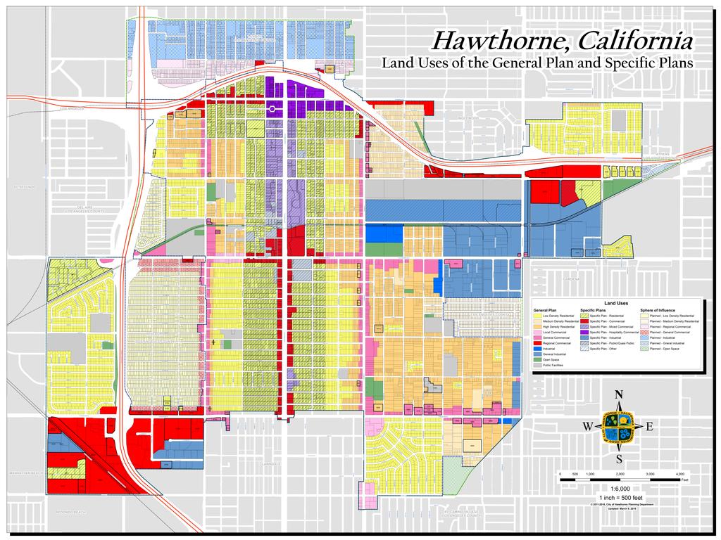
12 SECTION V LAND USES Land Use Policy Designations and Standards The Land Use Policy Map at the end of this Element applies Hawthorne's stated goals to specific land uses within the City. The Land Use Element designates five major categories of land use, which roughly correspond to existing development patterns. These categories include residential, commercial, industrial, public facilities and open space. The residential designation is further subdivided into three density ranges: low, medium, and high density. The commercial designation is also divided into three types: local, general, and regional commercial. The distribution of land uses is shown in Table 3. Table 3 also indicates residential development densities including potential ranges that exist under current zoning. (The maximum allowable densities are not achievable in many cases because existing street, alley, and lot configurations as well as setback, open space, and parking requirements serve to limit densities). Table 3 also indicates development intensities for the remaining land use designations and corresponding zoning districts. Table 3 shows the distribution of acreage within Hawthorne by land use designation. The Floor Area Ratios (FARs) shown for the commercial and industrial land uses indicate the maximum ratio of the gross floor area of all buildings on a lot to the lot area. As is the case with residential density designations, the achievable floor area ratios for some areas are less than the maximum. This is due to small lots as well as the necessity of complying with setback, open space, and parking requirements. Low Density Residential - Residential dwelling unit densities in this category will correspond to those intensities allowed under the R-] zoning designation which allows] to 8.0 dwelling units per acre. This particular land use designation is characterized by single-family detached units and is found throughout the city. Approximately 589 acres of the city are classified as Low Density Residential. Medium Density Residential - This land use designation applies to those areas of the city in which the allowable densities for residential development corresponds to the R-2 zoning designation of 8.1 to 17.0 dwelling units per acre. Housing units within this density range typically include a mix of single-family detached and attached units and duplexes. Approximately 111 acres have been designated for Medium Residential Density development (Table 4). High Density Residential - This land use designation applies to those areas of the City where the. allowable residential densities are between 17.1 and 30.0 units per acre and corresponds to the R-3 zoning designation. This designation identifies those neighborhoods where triplexes, fourplexes and multi-family 10 Land Use Element
13 units are located. An estimated 536 acres have been designated for High Density Residential development (Table 4). Local Commercial - This designation is a more restrictive land use category than General Commercial. This particular designation identifies those areas of the city where smaller professional offices, local services and retailing activities will be located. The maximum Floor Area Ratio will be 1.5. General Commercial - The general commercial land use designation refers to those office and commercial activities which serve both the local and regional markets. This is a more intense type of commercial development than that permitted in local commercial areas and involves larger firms which generate more traffic. The Floor Area Ratio for this development may go as high as 2.5 and subterranean parking is permitted. Regional Commercial - This designation accommodates commercial uses with primary orientation to freeway accessibility. Allowable uses within this designation include business parks, office, restaurants, auto centers, along with other general commercial uses. The Floor Area Ratio for this type of development may go as high as 3.5. General Industrial - The General Industrial designation includes generally largescale developments or industrial parks whose activities include heavy manufacturing, compounding, processing or fabrication. Such uses may also include warehousing, storage, freight handling, truck services, and terminals. An FAR of 1.75 is allowed for this designation. Industrial - The Industrial land use designation generally involves smaller scale development than the General Industrial designation and includes such uses as manufacturing, assembly, fabrication, wholesale, heavy commercial and office uses. This land use is appropriate as a buffer between non-industrial and general industrial land uses. The Floor Area Ratio for this type of development may go as high as Open Space/Parks - This designation includes open spaces which still exist within the City including parklands, horticultural plots, railroad rights-of-way, flood control channels, Southern California Edison easements, and small, isolated lots. Development in this category is limited to uses associated with recreation or other uses necessary in easements or flood control channels. A Floor Area Ratio ranging from 0.1 to 0.3 will be allowed for recreational uses. Public Facilities - The public facilities designation includes a variety of public uses such as institutional uses (elementary, junior high, and high schools) and government facilities (city hall, police and fire stations, libraries, etc.). Allowable 11 Land Use Element
14 development may include a Floor Area Ratio ranging from 0.3 to Approximately 203 acres have been designated as public facilities (Table 3). Implications of land Use Policy The implementation of the land use policy contained in this Element will permit additional development though this growth will be managed in a manner that is consistent with citywide goals and objectives. The distribution of land uses citywide is indicated in Table Land Use Element
15 Table 3 LAND USES & ZONING Land Use Designation Area (in acres) 1 Percentage of City Total Development Standards Corresponding Zones Area (in acres) 1 Percentage of City Total Residential 1, , LDR Low Density Residential du/acre R-1 Low Density Residential MDR Medium Density Residential du/acre R-2 Medium Density Residential HDR High Density Residential du/acre R-3 High Density Residential & R-4 Maximum Density Residential Commercial LC Local Commercial FAR = 1.5 CL Local Commercial GC General Commercial FAR = 2.5 CG General Commercial RC Regional Commercial FAR = 3.5 CR Regional Commercial Industrial LI Light Industrial FAR = 0.75 no corresponding zones GI General Industrial FAR = 1.75 M-1 Limited Industrial & M-2 Heavy Industrial Other Designations OS Open Space FAR = 0.3 OS Open Space PF Public Facilities FAR = 0.75 any zone Specific Plans 1, , DHSP Downtown Hawthorne CP Central Park CBC Century Business Center PG Pacific Glen See specific plans for details PV Prestige Village WG Willow Glen AMP Airport Master Plan CITY TOTAL 3, , including public rights of way 3,839 3,839 Sphere of Influence (not part of City) 649 LDR Low Density Residential 229 R-1 Low Density Residential MDR Medium Density Residential 67 R-2 Medium Density Residential CG General Commercial 54 CG General Commercial CR Regional Commercial 81 CR Regional Commercial GI General Industrial 218 M-2 Heavy Industrial Source: Planning Department Notes: 1 There are numerous properties having a land use and zone that do not match. 2 There are legacy zones that no longer have a corresponding Land Use.
16 v
GENERAL PLAN UPDATE SPECIFIC AREAS OF THE CITY
 GENERAL PLAN UPDATE SPECIFIC AREAS OF THE CITY Background There are a total of 14 specific areas that are being reviewed as part of the update of the General Plan. Requests to review these areas came from
2030 General Plan. December 6, 7 pm
 2030 General Plan GPAC Meeting #9 GPAC Meeting #9 December 6, 7 pm City Council Input on Working Draft Land Use Map Council discussed GPAC & PC versions of the working draft land use map 11/28 Council
Chapter 10: Implementation
 Chapter 10: Introduction Once the Comprehensive Plan has been adopted by the City of Oakdale, the City can begin to implement the goals and strategies to make this vision a reality. This chapter will set
4.2 LAND USE INTRODUCTION
 4.2 LAND USE INTRODUCTION This section of the EIR addresses potential impacts from the Fresno County General Plan Update on land use in two general areas: land use compatibility and plan consistency. Under
Land Use Survey Summer 2014
 Land Use Survey Summer 2014 North Ogden City, Utah Robert Scott, City Planner Travis Lund, Planning Intern Contents General Information... 1 Land Use Groups... 1 Urbanized Land Uses... 1 Residential...
CITY OF PORT ORCHARD
 CITY OF PORT ORCHARD ZONING DESIGNATIONS (Adapted from POMC Chapter 20.34 Zoning Districts, as adopted 6/13/2017) 20.34.110 Greenbelt zone (Gb). (1) Purpose. It is the purpose of the greenbelt zone to
DIVISION 1 PURPOSE OF DISTRICTS
 ARTICLE 2 ZONING DISTRICTS AND MAP DIVISION 1 PURPOSE OF DISTRICTS Section 2.101 Zoning Districts. For the purpose of this Ordinance, the City of Richmond is hereby divided into districts as follows: DISTRICT
ARTICLE B ZONING DISTRICTS
 ARTICLE B ZONING DISTRICTS Sec. 8-3021 Established. In order to protect the character of existing neighborhoods; to prevent excessive density of population in areas which are not adequately served with
INDIAN RIVER COUNTY, FLORIDA. The Honorable Members of the Planning and Zoning Commission DEPARTMENT HEAD CONCURRENCE
 Public Hearing Legislative INDIAN RIVER COUNTY, FLORIDA M E M O R A N D U M TO: The Honorable Members of the Planning and Zoning Commission DEPARTMENT HEAD CONCURRENCE Robert M. Keating, AICP; Community
Generic Environmental Impact Statement. Build-Out Analysis. City of Buffalo, New York. Prepared by:
 Generic Environmental Impact Statement Build-Out Analysis City of Buffalo, New York 2015 Prepared by: TABLE OF CONTENTS 1.0 INTRODUCTION 1 2.0 METHODOLOGY 2 3.0 EXISTING LAND USE 3 4.0 EXISTING ZONING
STAFF REPORT. Permit Number: Unlimited. Kitsap County Board of Commissioners; Kitsap County Planning Commission
 STAFF REPORT Permit Number: 15 00550 Unlimited DATE: March 2, 2016 TO: FROM: Kitsap County Board of Commissioners; Kitsap County Planning Commission Katrina Knutson, AICP, Senior Planner, DCD and Jeff
891941, , : COMPREHENSIVE PLAN AMENDMENT, COMMUNITY PLAN AMENDMENT, AND AREA-WIDE MAP AMENDMENT
 Application Nos. 891941, 891909, 891940: COMPREHENSIVE PLAN AMENDMENT, COMMUNITY PLAN AMENDMENT, AND AREA-WIDE MAP AMENDMENT Amendments to designate five parcels as Rural Industrial Center in the Alderton
ARTICLE 3: Zone Districts
 ARTICLE 3: Zone Districts... 3-1 17.3.1: General...3-1 17.3.1.1: Purpose and Intent... 3-1 17.3.2: Districts and Maps...3-1 17.3.2.1: Applicability... 3-1 17.3.2.2: Creation of Districts... 3-1 17.3.2.3:
Mohave County General Plan
 63 64 65 66 67 68 69 70 71 The Land Use Diagram is not the County's zoning map. 13 It is a guide to future land use patterns. Zoning and area plan designations may be more restrictive than the land use
CITY PLANNING COMMISSION COMPREHENSIVE PLAN AND REVIEW CRITERIA
 Page 3 CITY PLANNING COMMISSION COMPREHENSIVE PLAN AND REVIEW CRITERIA COMPREHENSIVE PLAN: The City Planning Commission uses the Comprehensive Plan as a guide in all land use matters. The Plan is available
4 LAND USE 4.1 OBJECTIVES
 4 LAND USE The Land Use Element of the Specific Plan establishes objectives, policies, and standards for the distribution, location and extent of land uses to be permitted in the Central Larkspur Specific
York Neighbourhood Area Structure Plan
 York Neighbourhood Area Structure Plan Office Consolidation March 2006 Prepared by: Planning and Policy Services Branch Planning and Development Department City of Edmonton Bylaw 7064 was adopted by Council
General Plan. Page 44
 VIII. RESIDENTIAL DEVELOPMENT IN NON-RESIDENTIAL LAND USE AREAS POLICY ISSUE Review the City s existing regulations and policies that allow residential land use in non-residential zoning districts. BACKGROUND
2. LAND USE DESIGNATIONS AND PRINCIPLES FOR DEVELOPMENT
 2. LAND USE DESIGNATIONS AND PRINCIPLES FOR DEVELOPMENT General areas have been designated for specific types of land use on the Future Land Use Map and are described in this section. In order to satisfy
RESOLUTION NO ( R)
") RESOLUTION NO. 2013-06- 088 ( R) A RESOLUTION OF THE CITY COUNCIL OF THE CITY OF McKINNEY, TEXAS, APPROVING THE LAND USE ASSUMPTIONS FOR THE 2012-2013 ROADWAY IMPACT FEE UPDATE WHEREAS, per Texas Local
RESOLUTION NO. 2013-06- 088 ( R) A RESOLUTION OF THE CITY COUNCIL OF THE CITY OF McKINNEY, TEXAS, APPROVING THE LAND USE ASSUMPTIONS FOR THE 2012-2013 ROADWAY IMPACT FEE UPDATE WHEREAS, per Texas Local
8Land Use. The Land Use Plan consists of the following elements:
 8Land Use 1. Introduction The Land Use Plan consists of the following elements: 1. Introduction 2. Existing Conditions 3. Opportunities for Redevelopment 4. Land Use Projections 5. Future Land Use Policies
HOUSING ELEMENT GOALS, OBJECTIVES, AND POLICIES
 HOUSING ELEMENT GOALS, OBJECTIVES, AND POLICIES GOAL 1: To promote the preservation and development of high-quality, balanced, and diverse housing options for persons of all income levels throughout the
SAN IPSE CAPITAL OF SILICON VALLEY
 COUNCIL AGENDA: 01/10/17 ITEM: 11.1(b) CITY OF SAN IPSE CAPITAL OF SILICON VALLEY CITY COUNCIL STAFF REPORT File No. C16-048 Applicant: Terry Pries Location 320 Race Street Existing Zoning LI Light Industrial
PLANNING COMMISSION STAFF REPORT February 19, 2015
 Community Development Department Planning Division 1600 First Street + P.O. Box 660 Napa, CA 94559-0660 (707) 257-9530 PLANNING COMMISSION STAFF REPORT February 19, 2015 AGENDA ITEM #7A PL13-0091 GENERAL
Chapter 2 Land Use. State of Land Use
 Ch2 6/21/2016 1 Chapter 2 Land Use The responsibility of a municipality to manage and regulate land use is rooted in its need to protect the health, safety, and welfare of local citizens. Although only
Bylaw No , being "Official Community Plan Bylaw, 2016" Schedule "A" DRAFT
 Bylaw No. 2600-2016, being "Official Community Plan Bylaw, 2016" Schedule "A" Urban Structure + Growth Plan Urban Structure Land use and growth management are among the most powerful policy tools at the
Comprehensive Plan 2015 to 2030 STATE OF LAND USE
 Chapter 2 Land Use The responsibility of a municipality to manage and regulate land use is rooted in its need to protect the health, safety, and welfare of local citizens. Although only acting as one section
City of Valdosta Land Development Regulations
 Chapter 206 Section 206-1 Base Zoning Districts Standards for Uses, Structures, and Property Development (B) (C) Principal Uses and Structures. Principal uses and structures permitted in each base zoning
Article 4. Zoning Districts
 Section 4.1: Establishment of Districts Article 4. Zoning Districts 4.1 Establishment of Districts For the purpose of this UDO, portions of the City as specified on the Official Zoning Map of the City
SANjOSE CAPITAL OF SILICON VALLEY
 COUNCIL AGENDA: 06/14/16 ITEM: 11.1(a) CITY OF ffr -3 SANjOSE CAPITAL OF SILICON VALLEY CITY COUNCIL STAFF REPORT File No. C16-015 Applicant: Owens Mortgage Investment Fund Location 455 Piercy Road Existing
Midwest City, Oklahoma Zoning Ordinance
 2010 Midwest City, Oklahoma Zoning Ordinance 9/2/2010 Table of Contents Section 1. General Provisions... 5 1.1. Citation... 5 1.2. Authority... 5 1.3. Purpose... 5 1.4. Nature and Application... 5 1.5.
Chapter 1107: Zoning Districts
 Chapter 1107: Zoning Districts 1107.01 Establishment of Zoning Districts (a) Districts Established In order to carry out the purpose of this code, the City is hereby divided into the zoning districts established
Provide a diversity of housing types, responsive to household size, income and age needs.
 8 The City of San Mateo is a highly desirable place to live. Housing costs are comparably high. For these reasons, there is a strong and growing need for affordable housing. This chapter addresses the
APPENDIX B RESIDENTIAL DENSITY
 APPENDIX B RESIDENTIAL DENSITY RESIDENTIAL DENSITY - SPECIFIC AREAS OF THE CITY Policy Issue Examine specific areas of the City to determine appropriate residential densities. Public comments have expressed
REZONING APPLICATION INSTRUCTIONS
 REZONING APPLICATION INSTRUCTIONS All required information, as stated on the Rezoning Application Checklist, must be included to qualify as a complete application. Upon receipt, staff will review the application
Final. Chapter Four: Land Use
 Chapter Four: Land Use Purpose and Intent Goals and Policies Existing Land Use Patterns AICUZ Airport Overlay Zone Zoning Existing Land Use Land Use Designations Land Use Demand and Forecast Existing Population
A Guide to the Municipal Planning Process in Saskatchewan
 A Guide to the Municipal Planning Process in Saskatchewan A look at the municipal development permit and the subdivision approval process in Saskatchewan May 2008 Prepared By: Community Planning Branch
Land Use Planning Analysis. Phase 2 Drayton Valley Annexation Proposal
 Land Use Planning Analysis Phase 2 Drayton Valley Annexation Proposal Prepared for Town of Drayton Valley Prepared by Mackenzie Associates Consulting Group Limited March, 2011 TABLE OF CONTENTS 1.0 INTRODUCTION...
THE REDEVELOPMENT PLAN
 PAGE 37 THE REDEVELOPMENT PLAN FUTURE LAND USE The Silver Terrace Redevelopment Area is currently designated as Redevelopment Area #4 on the City of Delray Beach Future Land Use Map (FLUM). This designation
Downtown Meridian Urban Renewal Area URBAN RENEWAL ELIGIBILITY REPORT. Prepared for The City of Meridian and The Meridian Development Corporation
 Downtown Meridian Urban Renewal Area URBAN RENEWAL ELIGIBILITY REPORT Prepared for The City of Meridian and The Meridian Development Corporation by McKibben + Cooper Architects June 19, 2002 Authorization
Planning Justification Report
 Planning Justification Report Kellogg s Lands City of London E&E McLaughlin Ltd. June 14, 2017 Zelinka Priamo Ltd. Page i TABLE OF CONTENTS Page No. 1.0 2.0 2.1 2.2 3.0 4.0 5.0 5.1 5.2 5.3 5.4 5.5 5.6
A. Land Use Relationships
 Chapter 9 Land Use Plan A. Land Use Relationships Development patterns in Colleyville have evolved from basic agricultural and residential land uses, predominate during the early stages of Colleyville
Chapter 5: Testing the Vision. Where is residential growth most likely to occur in the District? Chapter 5: Testing the Vision
 Chapter 5: Testing the Vision The East Anchorage Vision, and the subsequent strategies and actions set forth by the Plan are not merely conceptual. They are based on critical analyses that considered how
CHAPTER 50 LAND USE ZONES ARTICLE 50 BASIC PROVISIONS
 CHAPTER 50 LAND USE ZONES ARTICLE 50 BASIC PROVISIONS 50.010 - PURPOSE The purposes of this chapter are to establish land use zones required to implement the goals and policies of the Klamath County Comprehensive
Title 6 - Local Government Provisions Applicable to Special Purpose Districts and Other Political Subdivisions
 Title 6 - Local Government Provisions Applicable to Special Purpose Districts and Other Political Subdivisions CHAPTER 29. SOUTH CAROLINA LOCAL GOVERNMENT COMPREHENSIVE PLANNING ENABLING ACT OF 1994 1994
Draft for Public Review. The Market and Octavia Neighborhood Plan
 Draft for Public Review The Market and Octavia Neighborhood Plan San Francisco Planning Department As Part of the Better Neighborhoods Program December 00 . Housing People OBJECTIVE.1 MIXED-USE RESIDENTIAL
Pierce County Comprehensive Plan Review
 2015-2016 Pierce County Comprehensive Plan Review March 16, 2016 Introduction Planning and Management Policies Some of the policies governing both the planning and management of growth and change within
4.3 POPULATION/HOUSING/EMPLOYMENT
 This section analyzes the socioeconomic conditions within the. Within this section are discussions on the population characteristics, housing, and employment opportunities within the Planning Area. 4.3.1
ADUs and You! Common types of ADUs include mother-in-law suite, garage apartments and finished basements.
 ADUs and You! Accessory Dwelling Units Town of Lyons Accessory Dwelling Units (ADUs) are a form of housing that can be an important tool for diversifying and increasing the local housing stock. Lyons lost
United States Post Office and Multi-Family Residential; and, Single- Family Residence with an Apartment
 Planning Commission File No.: AME2013 0009 January 9, 2014 Page 2 of 9 Existing Land Use: United States Post Office and Multi-Family Residential; and, Single- Family Residence with an Apartment Surrounding
TREASURE COAST REGIONAL PLANNING COUNCIL M E M O R A N D U M. To: Council Members AGENDA ITEM 10A
 TREASURE COAST REGIONAL PLANNING COUNCIL M E M O R A N D U M To: Council Members AGENDA ITEM 10A From: Date: Subject: Staff April 20, 2007 Council Meeting Local Government Comprehensive Plan Review Draft
PLANNING FOR OUR FUTURE
 PLANNING FOR OUR FUTURE ELLSWORTH TOWNSHIP LAND USE AND POLICY PLAN The purpose of this Plan is to serve as a guide for the Township Trustees, Zoning Commission, Board of Zoning Appeals, developers, employers,
Appendix A: Guide to Zoning Categories Prince George's County, Maryland
 Appendix A: Guide to Zoning Categories Prince George's County, Maryland RESIDENTIAL ZONES 1 Updated November 2010 R-O-S: Reserved Open Space - Provides for permanent maintenance of certain areas of land
Rule of corner may need to be flexible i.e. context school, park. With a clustered approach. Should row housing go where fourplexes are?
 Fourplex Privacy Traffic issues by school (don t locate next to school) Highest density is furthest from park and school. Is this best? Family friendly (i.e. private green space, nicely designed, etc.)
ORDINANCE # AN ORDINANCE OF THE CITY OF ALBANY CITY COUNCIL APPROVING UNIVERSITY VILLAGE MIXED USE PROJECT ZONING MAP AMENDMENT
 Attachment 0 0 ORDINANCE #00 AN ORDINANCE OF THE CITY OF ALBANY CITY COUNCIL APPROVING UNIVERSITY VILLAGE MIXED USE PROJECT AMENDMENT WHEREAS, Planning and Zoning Code Section 0.00.00 (Amendments) prescribes
TOTTENHAM SECONDARY PLAN
 TOTTENHAM SECONDARY PLAN AMENDMENT NO. 11 TO THE OFFICIAL PLAN OF THE TOWN OF NEW TECUMSETH The following text and schedules to the Official Plan of the Town of New Tecumseth constitute Amendment No. 11
City of Coral Gables Planning and Zoning Staff Report
 City of Coral Gables Planning and Zoning Staff Report Applicant: Application: Public Hearing: Date & Time: Location: City of Coral Gables Zoning Code Text Amendment Giralda Plaza Overlay District Planning
GEORGE / GROSVENOR AREA STUDY RECOMMENDATIONS PLANNING CITY OF LONDON DEPARTMENT OF. MAY 1985 r----q
 GEORGE / GROSVENOR AREA STUDY RECOMMENDATIONS CITY OF LONDON DEPARTMENT OF PLANNING MAY 1985 r----q PREFACE On April 9, 1985, the Planning Committee held a public meeting regarding the St. George/Grosvenor
LONG-RANGE LAND USE PLAN
 LONG-RANGE LAND USE PLAN INTENT Completion of the I-66/Route 29 interchange and future expansion of improved telecommunication networks will substantially improve the desirability of the Gainesville area
Residential. Infill / Intensification Development Review
 Residential Infill / Intensification Development Review How Best to Manage The Compatible Integration of New Housing Within Established Residential Neighbourhoods Identification of Issues Privacy/overlook/height
PLANNING COMMISSION STAFF REPORT
 PLANNING COMMISSION STAFF REPORT MEETING DATE: 19 January 2017 APPLICANT: South Salt Lake City PROJECT NUMBER: T-17-002 REQUEST: APPLICANT: PREPARED BY: Recommendation to the South Salt Lake City Council
CITY OF SANTA ROSA COMMUNITY DEVELOPMENT DEPARTMENT STAFF REPORT FOR PLANNING COMMISSION SEPTEMBER 10, 2015 APPLICANT FILE NUMBER MJP
 ITEM NO. 9 CITY OF SANTA ROSA COMMUNITY DEVELOPMENT DEPARTMENT STAFF REPORT FOR PLANNING COMMISSION SEPTEMBER 10, 2015 PROJECT TITLE Yogurt Time Center ADDRESS/LOCATION 3093 Marlow Road ASSESSOR S PARCEL
density framework ILLUSTRATION 3: DENSITY (4:1 FSR) EXPRESSED THROUGH BUILT FORM Example 1
 EXPRESSED THROUGH BUILT FORM Example 1") density framework 4 ILLUSTRATION 3: DENSITY (4:1 FSR) EXPRESSED THROUGH BUILT FORM INTRODUCTION The Downtown Core Area contains a broad range of building forms within its relatively compact area. These
density framework 4 ILLUSTRATION 3: DENSITY (4:1 FSR) EXPRESSED THROUGH BUILT FORM INTRODUCTION The Downtown Core Area contains a broad range of building forms within its relatively compact area. These
Chapter Four Growth in the Next 20 years
 Chapter Four Growth in the Next 20 years Although the city of Fargo has pushed to the limits planned for in the original growth plan, the city still has substantial amounts of land available for growth.
PLANNING COMMISSION REPORT Regular Agenda - Public Hearing Item
 Z-12-29, 30, 32, 33, 34, 35, 36-11 to Item No. 5A 5G- 1 PLANNING COMMISSION REPORT Regular Agenda - Public Hearing Item PC Staff Report 02/27/2012 ITEM NO. 5A-5G Z-12-29, 30, 32, 33, 34, 35, 36-11 from
City of Peachtree City. Annexation Review Process
 City of Peachtree City Annexation Review Process Page 1 Annexation Review Process Step One: Initial annexation information The following information is to be completed by the property owner and/ or their
LAND USE, ZONING, & DEVELOPMENT STANDARDS
 02 LAND USE, ZONING, & DEVELOPMENT STANDARDS CHAPTER 2: LAND USE, ZONING, & DEVELOPMENT STANDARDS 2.1 Introduction The City s General Plan Land Use Map (LUE Figure 3) designates the Froom Ranch Area as
City of Brandon Brownfield Strategy
 City of Brandon Brownfield Strategy 2017 Executive Summary A brownfield is a property, the expansion, redevelopment, or reuse of which may be complicated by the presence or potential presence of a hazardous
TOWN OF ORO VALLEY PLANNING & ZONING COMMISSION MEETING DATE: December 6, 2011
 PLANNING & ZONING COMMISSION MEETING DATE: December 6, 2011 TO: FROM: SUBJECT: PLANNING & ZONING COMMISSION Matt Michels, Senior Planner mmichels@orovalleyaz.gov; tel. 229-4822 Public Hearing: Rancho de
WOODLAND AREA GENERAL PLAN URBAN DEVELOPMENT POLICY
 APPENDIX A WOODLAND AREA GENERAL PLAN URBAN DEVELOPMENT POLICY The following text indicates proposed amendments to the Woodland Area General Plan Urban Development Policy currently adopted and included
ARTICLE VII. NONCONFORMITIES. Section 700. Purpose.
 ARTICLE VII. NONCONFORMITIES. Section 700. Purpose. The purpose of this chapter is to regulate and limit the development and continued existence of legal uses, structures, lots, and signs established either
CITY OF LOGAN REDEVELOPMENT AGENCY. A Resolution approving the Auto Mall Community Development Project Area Plan
 -~ LOGAN CITY UNITED IN HRVICE fstt,blished 18t6 CITY OF LOGAN REDEVELOPMENT AGENCY Resolution No. IS-03 RDA A Resolution approving the Auto Mall Community Development Project Area Plan WHEREAS, the Redevelopment
PLANNED UNIT DEVELOPMENTS (Ordinance No.: 3036, 12/3/07; Repealed & Replaced by Ordinance No.: 4166, 10/15/12)
") 159.62 PLANNED UNIT DEVELOPMENTS (Ordinance No.: 3036, 12/3/07; Repealed & Replaced by Ordinance No.: 4166, 10/15/12) A. PURPOSE 1. General. The Planned Unit Development (PUD) approach provides the flexibility
159.62 PLANNED UNIT DEVELOPMENTS (Ordinance No.: 3036, 12/3/07; Repealed & Replaced by Ordinance No.: 4166, 10/15/12) A. PURPOSE 1. General. The Planned Unit Development (PUD) approach provides the flexibility
Ann Arbor Downtown Zoning Evaluation
 Ann Arbor Downtown Zoning Evaluation Options Workbook ENP & Associates in cooperation with the City of Ann Arbor September, 2013 Photo Courtesy of Andrew Horne, February 9, 2013 Introduction Thank you
Salem HNA and EOA Advisory Committee Meeting #6
 Salem HNA and EOA Advisory Committee Meeting #6 Residential Land Policies Employment Land Policies Policy Discussions with the Committee Outcome of today s meeting Direction from this Committee on proposed
4.11 POPULATION AND HOUSING
 4.11 POPULATION AND HOUSING INTRODUCTION This section of the Draft Environmental Report (Draft EIR; DEIR) describes the current population and demographic characteristics and housing and employment conditions
Allenspark Townsite Planning Initiative Community Meeting July 23, Boulder County Land Use Department
 Allenspark Townsite Planning Initiative Community Meeting July 23, 2018 OBJECTIVES FOR THIS MEETING Update the community on developments, outcomes of recent discussions Recognizing the revised scope (Allenspark
Analysis of Infill Development Potential Under the Green Line TOD Ordinance
 Analysis of Infill Development Potential Under the Green Line TOD Ordinance Prepared for the Los Angeles County Second Supervisorial District Office and the Department of Regional Planning Solimar Research
Policy Issues City of Knoxville Zoning Code Update
 Policy Issues City of Knoxville Zoning Code Update ADU's (Accessory Dwelling Units) The draft zoning ordinance update permits ADU s as an accessory use in all single-family residential zoning districts.
GUIDELINES AND CRITERIA. For Granting Tax Abatement in the North Killeen Revitalization Area. Designated by the City of Killeen, Texas
 GUIDELINES AND CRITERIA For Granting Tax Abatement in the North Killeen Revitalization Area Designated by the City of Killeen, Texas Under Tax Code, Chapter 312 I. PURPOSE The designation of a Tax Abatement
Zoning Ordinance Update Module 1 PUBLIC DRAFT Article 2: Zoning Districts Article 3: Use Regulations Article 6: Definitions (partial)
") Zoning Ordinance Update Module 1 PUBLIC DRAFT Article 2: Zoning Districts Article 3: Use Regulations Article 6: Definitions (partial) Syracuse Zoning Ordinance Contents Article 1: General Provisions...
Zoning Ordinance Update Module 1 PUBLIC DRAFT Article 2: Zoning Districts Article 3: Use Regulations Article 6: Definitions (partial) Syracuse Zoning Ordinance Contents Article 1: General Provisions...
CITY OF COLD SPRING ORDINANCE NO. 304
 CITY OF COLD SPRING ORDINANCE NO. 304 AN ORDINANCE AMENDING THE CITY CODE OF COLD SPRING BY ADDING SECTIONS 555 AND 510 PERTAINING TO PAYMENT-IN-LIEU-OF-PARKING THE CITY COUNCIL OF THE CITY OF COLD SPRING,
MIDWAY CITY Municipal Code
 MIDWAY CITY Municipal Code TITLE 9 ANNEXATION CHAPTER 9.01 PURPOSE CHAPTER 9.02 GENERAL REQUIREMENTS CHAPTER 9.03 PROPERTY OWNER INITIATION OF ANNEXATION CHAPTER 9.04 PROCEDURES FOR CONSIDERATION OF PETITION
TRANSFER OF DEVELOPMENT RIGHTS
 STEPS IN ESTABLISHING A TDR PROGRAM Adopting TDR legislation is but one small piece of the effort required to put an effective TDR program in place. The success of a TDR program depends ultimately on the
PLANNING COMMISSION STAFF REPORT
 PLANNING COMMISSION STAFF REPORT West Capitol Hill Zoning Map Amendment Petition No. PLNPCM2011-00665 Located approximately at 548 W 300 North Street, 543 W 400 North Street, and 375 N 500 West Street
FEC The purpose of the Flexible Use Employment Center classification is to provide for areas of employment uses situated on individual sites or in
 FEC The purpose of the Flexible Use Employment Center classification is to provide for areas of employment uses situated on individual sites or in campus-style parks. Primary uses in the FEC classification
GENERAL DESCRIPTION STAFF RECOMMENDATION IMPLEMENTATION REQUIREMENTS
 Application No.: 891418 Applicant: AREA-WIDE MAP AMENDMENT Rezone two parcels from Moderate Density Single Family (MSF) to Neighborhood Center (NC) and Employment Center (EC). Charles Bitton GENERAL DESCRIPTION
6. RESIDENTIAL ZONE REGULATIONS
 6. RESIDENTIAL ZONE REGULATIONS PART 6A PURPOSE OF CHAPTER (1) The purpose of this Chapter is to provide detailed regulations and requirements that are relevant only to residential zones and specific residential
POLICY AMENDMENT AND LAND USE AMENDMENT RICHMOND (WARD 8) RICHMOND ROAD SW AND 24 STREET SW BYLAWS 10P2018 AND 52D2018
 RICHMOND ROAD SW AND 24 STREET SW BYLAWS 10P2018 AND 52D2018") Page 1 of 12 EXECUTIVE SUMMARY This land use amendment proposes to redesignate two parcels of approximately 0.30 hectares ± (0.74 acres ±) located in the community of Richmond from DC Direct Control District
Page 1 of 12 EXECUTIVE SUMMARY This land use amendment proposes to redesignate two parcels of approximately 0.30 hectares ± (0.74 acres ±) located in the community of Richmond from DC Direct Control District
Chapter SPECIAL USE ZONING DISTRICTS
 Chapter 20.20 Sections: 20.20.010 Urban Transition (U-T) Zoning District 20.20.020 Planned Development (P-D) Zoning Districts 20.20.010 Urban Transition (U-T) Zoning District A. Purpose. The purpose of
CHAPTER Committee Substitute for Committee Substitute for Senate Bill No. 2188
 CHAPTER 2004-372 Committee Substitute for Committee Substitute for Senate Bill No. 2188 An act relating to land development; amending s. 197.502, F.S.; providing for the issuance of an escheatment tax
REZONING GUIDE. Zone Map Amendment (Rezoning) - Application. Rezoning Application Page 1 of 3. Return completed form to
 - Application. Rezoning Application Page 1 of 3. Return completed form to") COMMUNITY PLANNING & DEVELOPMENT REZONING GUIDE Rezoning Application Page 1 of 3 Zone Map Amendment (Rezoning) - Application PROPERTY OWNER INFORMATION* PROPERTY OWNER(S) REPRESENTATIVE** CHECK IF POINT
COMMUNITY PLANNING & DEVELOPMENT REZONING GUIDE Rezoning Application Page 1 of 3 Zone Map Amendment (Rezoning) - Application PROPERTY OWNER INFORMATION* PROPERTY OWNER(S) REPRESENTATIVE** CHECK IF POINT
REQUEST STAFF RECOMMENDATION. On April 26, 2012, Signature Books Inc., represented by Dave Richards, submitted petitions for the following amendments:
 PLANNING COMMISSION STAFF REPORT Signature Books Zoning Map Amendment and an Amendment to the North Temple Area Plan Petitions PLNPCM2012-00254 PLNPCM2012-00255 July 11, 2012 Planning Division Department
CHAPTER 2: HOUSING. 2.1 Introduction. 2.2 Existing Housing Characteristics
 CHAPTER 2: HOUSING 2.1 Introduction Housing Characteristics are related to the social and economic conditions of a community s residents and are an important element of a comprehensive plan. Information
PC Staff Report 11/18/2013 Z Item No. 1-1
 Z-13-00401 Item No. 1-1 PLANNING COMMISSION REPORT Regular Agenda - Public Hearing Item PC Staff Report 11/18/2013 ITEM NO. 1: Z-13-00401 IG (General Industrial) District TO CS (Strip Commercial) District;
Zoning Analysis. 2.0 Residential Use. 1.0 Introduction
 Zoning Analysis 1.0 Introduction For zoning to be an effective community development tool, it must recognize the unique land use characteristics of the various portions of the community. The Lawrence Zoning
SECTION 3. Housing. Appendix A LAND USE DEFINITIONS
 SECTION 3 Housing A Appendix A LAND USE DEFINITIONS A-2 Housing Commission Attachment B Appendix A Land Use Definitions INTRODUCTION The Land Use Map (Figure A-1) of Community Vision 2040 illustrates the
APPENDIX D: DEFINITIONS
 D APPENDIX D: DEFINITIONS Terms used throughout the 2040 Comprehensive Plan should be interpreted using the definitions provided in this appendix. For interpretation of any term not defined, defer to the
3.1. OBJECTIVES FOR RESIDENTIAL LAND USE DESIGNATIONS GENERAL OBJECTIVES FOR ALL RESIDENTIAL DESIGNATIONS
 3. RESIDENTIAL LAND USE DESIGNATIONS INTRODUCTION The Residential land use designations provide for housing and other land uses that are integral to, and supportive of, a residential environment. Housing
City of Sacramento Zoning Code - Zoning Descriptions Excerpt from website on April 5, 2010
 City of Sacramento Zoning Code - Zoning Descriptions Excerpt from website on April 5, 2010 RE Rural Estates Zone. This is a very low density residential zone. It is intended to be applied primarily to