D OCUMENTATION PATRIMONIALE. Welcome in Belgium. CLRKEN EuroGeographics November Marc Vanderschueren. Federal Public Service FINANCE
|
|
|
- Dayna McCormick
- 5 years ago
- Views:
Transcription

1 Welcome in Belgium
2 Introduction The belgian administrative structure The General Administration of Patrimonial Documentation 3.1 Concepts Cadastre Registry Mortgage 3.2 Structure Surveys and Valuations Legal Security Collection & Exchange of Information Patrimonial Departments 3.3 The cadastral documentation The Cadastral parcel Plan The Cadastral Matrix The evaluation document 3.4 Some major projects 3.5 Some partnerships of the GAPD 4. PUBLIC RESTRICTIONS 2
 Population density: 355 Inhabitants/ km² Capital :Brussels Motto : \"L'Union fait la force\" Anthem : La \"Brabançonne\" Official languages: Dutch, French, German")
3 Population: Inhabitants (2013) Population density: 355 Inhabitants/ km² Capital :Brussels Motto : "L'Union fait la force" Anthem : La "Brabançonne" Official languages: Dutch, French, German Government : Parliamentary Democracy and Constitutional Monarchy - King: Philippe Independence: 4 /10/1830 Accession UE : 25 /3/ 1957 Total Area: km² (Water Area: 6,4 %) 3
4 2. THE BELGIAN ADMINISTRATIVE STRUCTURE FEDERAL GOVERNMENT THE KING 3 REGIONS 3 COMMUNITIES 4

5 Belgian regions 5
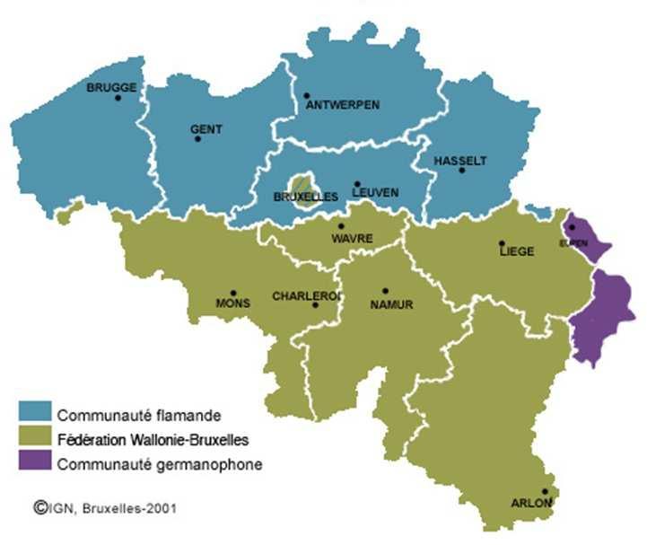
6 Belgian communities
7 3. THE GENERAL ADMINISTRATION OF PATRIMONIAL DOCUMENTATION (GAPD) GAPD is part of the Finances 7
8 3.1 THE CONCEPTS OF LAND REGISTER (CADASTRE), REGISTRY AND MORTGAGE IN BELGIUM Cadastre Historically Belgium has a Napoleonic land register. Notwithstanding the wish to create a legal land register of "land book" type, it is of "personal" type. The registration in the land register and cadastral plans is not ipso facto equivalent to a "title deed". The agreements as regards property rights must be drawn up by a public officer (in most of cases a notary) in order to be transcribed in the Mortgage Registry Office. Therefore it is necessary that the immovable property mentioned in the transaction is identified (in particular at the graphic level) in the most complete manner and without any uncertainty 8
9 3.1.2 Registry The information which is mentioned in the registers concerns the deeds of transfer and the adjudicative decrees. The Registry duty has a very important consequence as regards the civil law in addition to its fiscal objective: The Registry is the basis for the drawing up of the land register. it gives an indisputable date to the deeds which are registered. a registered deed is enforceable against third persons. It enables, thanks to documentation, to control the perception of the inheritance taxes. Cadastral registers can be updated thanks to this. It furnishes information to the Direct Tax Administration, to the VAT, and to some foreign states. 9
10 3.1.3 Mortgage There are two main registers: registers of transcriptions and registers of registrations ( privileges and mortgages). The transcription consists of a copy of the deed with a margin, in which a note can be drawn up, pursuant to Article 3 of the law concerning mortgages. The registration consists of a copy of the statement (or summary of the deed mentioning the main information : name, identity of the parties involved, amount of the mortgage and identification of the immovable property).
11 THE PATRIMONIAL DOCUMENTATION = A NEW CHART ORGANIZATION GENERAL ADMINISTRATOR DEPARTMENT OF THE GENERAL ADMINISTRATOR FUNCTIONAL EXPERTISE AND SUPPORT CELL PERSONNEL OPERATIONAL EXPERTISE AND SUPPORT CELL MANAGEMENT CONTROL PATRIMONIAL DEPARTMENTS SURVEYS AND VALUATIONS COLLECT AND EXCHANGE OF INFORMATION LEGAL SECURITY CENTRE SPECIAL EVALUATIONS CENTRE 11
12 12
13 3.2.1 Surveys and Valuations (Land Register/Cadastre) guarantees: - the measurement of the parcels of land and the constructions; - the determination of the boundaries of the pieces of land as well as the administrative boundaries within the framework of the updating of the cadastral map and the development of a geographic information system; - the revision of the cadastral parcel plan on the basis of the land surveyors plans; - the determination of the different values of immovable property such as cadastral income in favor of the estimating authorities and the verification of the market values in respect of the registration duties and the inheritance taxes; - the verification of the construction value in respect of VAT as well as the value of movable assets such as holdings of enterprises, works of art, etc. 13
14 14
15 3.2.2 Legal Security (Registry and Mortgage) guarantees: - the collection of the registration duties and the inheritance taxes (which are mainly transferred to the Regions), the mortgage duties, the court fees and other duties and taxes; - the publication, by the Mortgage Registry Office, of the public officers instruments; - the update of our patrimonial documentation (registers). Some Fiscal competences (registration duties & inheritance taxes) for the Flemish Region were transferred to this Region starting from 1/1/
16 16
17 17
18 18
19 3.2.3 Collection & Exchange of Information guarantees: - the collection and exchange of the patrimonial information, both movable and immovable, on the natural or legal persons; - the diffusion of this information to both the public and the private authorities or to the citizens. As a matter of course, this mission must be carried out in accordance with the provisions relating to the protection of privacy. 19
20 3.2.4 The Administration Patrimonial Departments guarantees: - the acquirement, amicably or through expropriation, of immovable property that is useful or absolutely necessary to the realization of the infrastructures decided on by the public authorities; - the sale of the immovable property of these authorities; - in the capacity as public notary, the drawing up of the authentic deeds relating to the acquisitions and the sales as well as certain special deeds on account of public enterprises; - the management of the private immovable patrimony of the State, either by renting it out or conceding it, or by selling it; - the recovery of the movables coming from various Administrations which have been put out of service; - the selling, recycling or even destroying of the seized goods. Useful links: - site of the Patrimonial Departments ( selling of movable and immovable properties, forms, specifications, contacts, etc. - site Finshop ( selling of movable properties, shop selling Regionalisation : The Acquisition Committees will be transferred to the Regions (Flemish Region, Walloon Region and Brussels-Capital Region) + one. 20
21
22 3.3 THE CADASTRAL DOCUMENTATION The Cadastral parcel Plan Topographical representation of the immovable properties: the cadastral parcels and the buildings. Each parcel is identified by a unique identifier called CaPaKey. Initially established on drawing paper and maintained as-is (primitive plan). Firstly updated on strong white paper (additional parcel plan). It has been digitalized in collaboration with regions during 90 s and The whole country is actually divided in cadastral sheets corresponding to a subdivision of the territory contained in a paper cadastral plan. Primitive plan is mostly at 1/1,250 and 1/2,500 scales. Sheets completely remeasured afterwards are at 1/1,000 and 1/2,000 scales and sometimes at 1/500. A snapshot of 1st january situation is archived each year. The Plan (1st january of the current year versions) can be consulted on CADGIS and is updated using CadMap. 22


23

24
25 3.3.2 The Cadastral Matrix It is the big book of the immovable property. Established for each cadastral municipality. At the first beginning in 1926, it was established in tomes called 212, then in mobile cards since 1927 to the period During , the cadastral matrix has been digitalized. Active situation was available on microcards 212 AM. Passive situation was available on microcards 212 PM. Now Matrix is consultable via CADNET, intranet and CD-rom. All the assets subject to to the same property right in the same division are contained in the same article. Update for each ownership and/or immovable consistency change. A 1st january situation is archived each year. 25
26 3.3.3 The evaluation document Established for each built parcel. Gives the complete description of the building. Contains every element for the calculation of the cadastral income. Presented as a simple duplex card for the ordinary buildings or as a descriptive for the apartment buildings and the industrial or exceptional buildings (BIBE). 26
27 27
28 28
29 3.4 SOME MAJORS PROJECTS STIPAD PATRIS the central element of STIPAD is the patrimonial database, called PATRIS (PATRimony Information System). 29 the main objectives are : to collect, to manage, to update and to communicate all the information related to a natural person or legal entity (active and passive situation); to ensure the juridical security of data. An other objective is to create connections with other existing databases concerning the same areas, managed by other management levels. This application manages the different folders for the update of this information by the communication between the different stakeholders respecting procedures.
30 3.4.2 DER Project developed by GAPD with the collaboration of the Belgian Notaries Royal Federation (BNRF) and the Agency for the Administrative Simplification (AAS); Notaries can send online deeds and annexes to Registry and Mortgage registry; The receivers of Registry and the registrars of Mortgages can send back online to the notaries the deeds with the registry relationship/formal mortgage relationship; DER means «Document Electroniquement Reconnaissable» (Electronically Recognizable Document) and is known as «E-enregistrement» by notaries; This annihilates substantially the «blind spot» period of legal insecurity which is the period between the signature of the authentic deed and its receiving at the Mortgage registry for the formal transcription. 30
 Fedopress/ Scriptura Management of the electronic documents Filenet Plans and geographical data Electronic documents requests")
31 STIPAD Architecture STIPAD Gestion des Authentifications CCFF / Autorisations IAM DIM Interface for the incoming documents (Scanning) tools to consult and perform queries in PATRIS Management of the work and the workflow Interface for the outgoing documents (Printing) Fedopress/ Scriptura Management of the electronic documents Filenet Plans and geographical data Electronic documents requests PATRIS dossiers missions deeds mutations properties rights persons SITRAN Extraction, Consolidation and uploading of historical data CadGIS CADNET LOCO HYPO TP380 TP385 DER 31
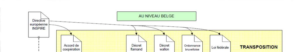
32 3.4.3 INSPIRE INSPIRE : legal aspects As a reminder, the directive 2007/2/EC of the European Parliament and the Council of 14 March 2007 establishing an Infrastructure for Spatial Information in the European Community (INSPIRE) was published in the official Journal on the 25th April The INSPIRE directive entered into force on the 15th May The Directive also requires that common Implementing Rules (IR) are adopted in a number of specific areas such as Metadata, Data Specifications, Network Services, Data and Service Sharing and Monitoring and Reporting. In Belgium, the INSPIRE directive has been converted in a Flemish decree and a Walloon decree, a Brussels ordinance and a federal law. Between the three Regions and the federal government, there exists a cooperation agreement to coordinate the implementation between the different governments in Belgium. Each entity provides his own databases for INSPIRE and partnerships are planned for data themes that are common between regions and federal as addresses and buildings. There is a geoportal for each entity. The federal participation is led by NGI in order to provide a geoportal and share the different services from the federal administrations. 32


33 33


34
35 3.4.4 CADGIS Launched in 2003, the objective of the project is to manage the cadastral data in a GIS; Three essential stages: Continuous cadastral plan: cadastral sheets have to be assembled together Establishment of a spatial database Integration of every cadastral information (ownership register) Two releases: Consultation and e-services Update and management of the cadastral parcel plan 35
36 CADGIS release 1 The user can freely navigate on the cadastral map by using a viewer; Search for a specific cadastral parcel according to different criteria (by address, by cadastral number, by coordinates) available; Application basic mapping functionalities (measurement, identification, print, ); A legal cadastral extract document or a digital data copy can be ordered online; Two different access modes are offered to public: a public access (limited by laws and standards related to personal data protection and privacy) and a privileged access for the holders of an electronic identity (eid) card (or a token) Conventioned surveyors authenticated with the help of their eid card, can also directly download a vectorial data copy of an area of the cadastral map in order to integrate it in their own survey or GIS. 3 services available: two view services concerning the INSPIRE themes cadastral parcels and administrative units and a discovery service; Another WMS (view service) containing all the cadastral map layers is also accessible. 36
37 Link with CadGIS In November 2012, the GAPD has launched its new CadGIS system that enables on-line visualization of the cadastral map. 37
38 CADGIS release 2 This part focuses on the update and the management of the continuous Cadastral parcel Plan as a geodatabase; CAD tools will be provided in order to draw and edit graphic objects; Topological rules controlled after each update; This will replace the actual application (CadMap). 38
39 3.4.5 PRECAD AND THE PLAN ENCLOSED WITH THE DEED Scope of the decree The new decree applies in every case as regards the creation of a new cadastral parcel. The creation of a new cadastral parcel is necessary in the following cases: a land allotment; an exchange between parcels to be registered in the cadastral parcel plan; a parcel to create in public property; a privative batch to create in an immovable property; an expropriation of a part of the properties; a land reparcelling; a right to tenancy as regards a part of the parcel Two stages Since January 1st 2014 the implementation of the principle of the previous submission of the delimitation plan. Since a later date, which must be still determined by the Ministry of Finance, implementation of the principle of prior request of parcel identification numbers. 39
40 Previous submission of the delimitation plan (PreCad) Principles In case of the creation of a new parcel the notary must know the reference number of the delimitation plan in order to draw up the deed. At the request of the notary or on his/her own initiative the surveyor-expert submits (preferably by ) his/her plan The Administration Surveys & Valuations registers the plan in the database of the delimitation plan and gives it a reference number. That number will be sent to the applicant within the time period of twenty calendar days. The surveyor passes on the reference number to the notary. He/She can examine the plan online through The notary can also examine it online. The notary draws up his/her deed mentioning the reference number of the delimitation plan. The deed is afterwards transcribed and registered pursuant to the usual procedures, without any handling of the plan. The Administration Surveys & Valuations (Cadastre) updates the cadastral parcel plan on the basis of the plan registered in the database of the delimitation plans. 40
41 3.4.6 CADBUILD Internal objectives : Digitalize the evaluation documentation; Encoding and editing tools (Calculation, drawing, traceability); Flexible, polyvalent and evolutive application; Exchange format with STIPAD (XML, PDF documents in Filenet); Evaluate all property types (offices, Industrial and enterprise buildings, commerces, ); Create an evaluation sketch and link it with pictures (5), plans, ; Statistics tools (workload - performances); Fulfill ICT standards (Server Java db2 LDAP ) External objectives : Create an identity card for buildings (details, summary); Taking account standards used by external experts; Make diffusion easier ( PDF, Export Db, ) Providing exchange possibilities (plans-surfaces- ) 41
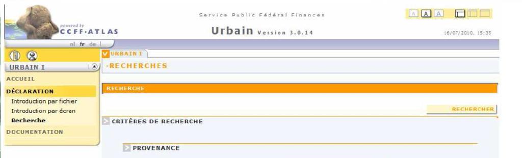
42 3.4.7 URBAIN Enables digital provision by the municipalities to GAPD of 220 lists containing the delivered building permissions, plus the modifications to properties. Information can be completed using information complements available for communicated permissions and modifications, eg. start and/or end date of work, date and result of a conformity control. Encoding realized either globally with a XML file containing all the permissions and work of a determined period, or individually for each permission using entry screen available in URBAIN. The application is available for municipalities via Internet. 42
43 The identification of the municipalities users is realised by using the electronic identity card (eid) or the «citizen token»

44 44
45 3.5 SOME PARTNERSHIPS OF THE GAPD Partnership with the Belgian National Geographic Institute (NGI) two of its representatives are members of the Management Committee and have voting rights. In July 2004 the two institutions also signed a co-operation agreement in the context of the development of a federal platform for geographical information. Collaboration with the Private Surveyors Before 2014 : - an agreement with about 1500 private Surveyors - the private surveyor makes his maps in accordance with the standards and directly provides the Cadastre with an original copy of the map - the private surveyor has a free access to some cadastral data or files - the Cadastre has set up a Databank of the maps of the surveyors Since 2014 : Precad 45
46 Collaboration with the three Regions and the towns in Belgium - URBAIN - BuNI - BestAddress Collaboration with Notaries -DER Collaboration with Architects Two mainlines: - testify the implantation of a new building - testify the consistency of the building 46
47 Public restrictions The main public restrictions are the praedial servitude. A servitude on a land parcel in favour of a second parcel. The owner of the second parcel benefits from the servitude. When the second property is transferred, the benefit of the servitude passes to the new owner. Organized By regulations : the civil Code and the Rural Code (the Countryside Code). The other public restrictions are organized by the Regional Territorial Planning. The rules are different in the 3 REGIONS. There are also restrictions organized by the Provinces, the Towns or Villages..
48 Conclusion & Questions? Thank you Questions to: 48
The Private Surveyor Privileged Partner of the Belgian Cadastre
 The Private Surveyor Privileged Partner of the Belgian Cadastre Francis GABELE and Marc VANDERSCHUEREN, Belgium Key words: Private surveyor, Professional code of ethics, Public Officer, Partner, Preliminary
The General Administration of the Patrimonial Documentation of Belgium Turned Towards the Future
 The General Administration of the Patrimonial Documentation of Belgium Turned Towards the Future Francis GÄBELE and Marc VANDERSCHUEREN, Belgium Keywords: Cadastre; Digital cadastre; e-governance; Land
The principal tasks or competencies of the General Directorate of Cadastre are:
 4th Quality Conference 1/7 1) Title of the case. Spanish e Cadastre ( Virtual Office of Cadastre, or OVC). An open space for sustainable quality in cadastral data, working with land management administrations.
SECTOR PUBLIC CADASTRES AND REGISTERS MARKET PARTICIPANTS
 E-SERVICES TO CITIZENS, GOVERNMENT AND BUSINESSES. LITHUANIA EXPERIENCE Arvydas Bagdonavičius State Enterprise Centre of Registers Arvydas.Bagdonavicius@registrucentras.lt REGISTERS AND IS MANAGED BY THE
Egyptian Nationwide Title Cadastre System
 Kholoud SAAD, Egypt Key words: Cadastre, Registration, Urban, Rural, National Cadastre, Automation, reengineering. SUMMARY With growing need for integrated information, Enterprise Solutions has become
ABSTRACT Land Administration System in Lithuania
 ABSTRACT Land Administration System in Lithuania 1. General introduction to the Lithuanian Land Administration System and State Enterprise Centre of Registers ( shortly SECR) Lithuania has established
Amalia Velasco Carlos Alonso Luis Virgos Fernando Serrano
 Inspire services of the Spanish Directorate General for Cadastre and its use to resolve an old problem of coordination between Spanish Cadastre and Land Registry. Amalia Velasco Carlos Alonso Luis Virgos
Estonian e-cadastre as basis for efficient land management
 Estonian e-cadastre as basis for efficient land management Priit Kuus Estonian Land Board November 14, 2017 Tallinn Scope of data Cadastral parcels (as of October 2017) 693 026 cadastral parcels, i.e.
Land Cadastre Act. Chapter 1. Passed RT I 1994, 74, 1324 Entry into force (except 3 which entered into force on 1.01.
 Issuer: Riigikogu Type: act In force from: 01.01.2011 In force until: 31.12.2014 Translation published: 24.10.2014 Passed 12.10.1994 RT I 1994, 74, 1324 Entry into force 08.11.1994 (except 3 which entered
Cadastre and Land Registration in Europe
 Annex A: Questionnaire 2007 for Information Resource Cadastre and Land Registration in Europe Introduction This questionnaire is based on the EuroGeographics vision document 'Cadastre and Land Registration
BULGARIAN CADASTRE A GUARANTEE FOR THE OWNERSHIP RIGHTS IN IMMOVABLE PROPERTIES
 4 TH INTERNATIONAL CONFERENCE RECENT PROBLEMS IN GEODESY AND RELATED FIELDS WITH INTERNATIONAL IMPORTANCE February 28 - March 2, 2007, Inter Expo Centre, Sofia, Bulgaria BULGARIAN CADASTRE A GUARANTEE
Cadastral services and virtual office in e-cadastre
 Cadastral services and virtual office in e-cadastre Priit Kuus Estonian Land Board October 26, 2016 Coimbra Scope of data Cadastral parcels (as of September 2016) 674 383 cadastral parcels, i.e. 97,7 %
The Challenge to Implement International Cadastral Models Case Finland 1
 The Challenge to Implement International Cadastral Models Case Finland 1 Tarja MYLLYMÄKI and Tarja PYKÄLÄ, Finland Key words: cadastre, modelling, LADM, INSPIRE SUMMARY Efforts are currently made to develop
AREC responsibilities, data and registries and the way of their distribution
 Data as a basis of the digital society PCC, 13-15 March 2018, Sofia AREC responsibilities, data and registries and the way of their distribution Vlatko Dimovski Agency for Real Estate Cadastre (AREC) the
Building Integrated Land Information Systems and Development of NSDI
 Stig JÖNSSON, Sweden Key words: Land administration, land information systems, property formation, spatial data infrastructure, Inspire, institutional cooperation SUMMARY Lantmäteriet the Swedish agency
REFORM OF LAND CADASTRE IN LITHUANIA
 REFORM OF LAND CADASTRE IN LITHUANIA Romualdas KASPERAVICIUS, Lithuania Key words: ABSTRACT Main aim for every Government is to create legal, financial and organisational circumstances for real property.
NEW DEVELOPMENTS IN THE REAL PROPERTY REGISTER AND CADASTRE IN LITHUANIA
 NEW DEVELOPMENTS IN THE REAL PROPERTY REGISTER AND CADASTRE IN LITHUANIA Jaunius Grigas E-mail: jaunius.grigas@registrucentras.lt Verona, 2008 FUNCTIONS OF STATE ENTERPRISE CENTRE OF REGISTERS Registration
LAND ADMINISTRATION IN LITHUANIA: CHALLENGES AND PERSPECTIVES
 UNECE WPLA Workshop Influence of Land Administration on People and Business, Cavtat, Croatia, October 2-3, 2008 LAND ADMINISTRATION IN LITHUANIA: CHALLENGES AND PERSPECTIVES Kestutis Sabaliauskas, Director
Theme II. Customers and Services NEW PROJECTS OF THE AGENZIA DEL TERRITORIO. Marco SELLERIE
 UNITED NATIONS ECONOMIC COMMISSION FOR EUROPE COMMITTEE ON HUMAN SETTLEMENTS WORKING PARTY ON LAND ADMINISTRATION Workshop "Customer - Co-operation - Services" Vienna, Austria 12-13 September 2002 Theme
The Development of the Austrian Cadastre from Documentation to an Integrated Planning and Decision Support System
 The Development of the Austrian Cadastre from Documentation to an Integrated Planning and Decision Support System WPLA - Working Party on Land Administration 15-17 October 2014, Vienna, Austria Wernher
LAND REGISTRATION SYSTEM OF THE REPUBLIC OF CROATIA
 "On the last day of the Creation God desired to crown His work, and thus created Kornati Islands out of tears, stars and breath." (George Bernard Shaw) LAND REGISTRATION SYSTEM OF THE REPUBLIC OF CROATIA
International funding projects in Republic Geodetic Authority
 International funding projects in Republic Geodetic Authority Serbia: Republic Geodetic Authority Workshop Exploring Funding Instruments for NMCA 7-8 November 2012 Republic Geodetic Authority Republic
National Spatial Data Infrastructure development in Republic of Macedonia
 National Spatial Data Infrastructure development in Republic of Macedonia Sonja Dimova, state advisor for geomatics AGENCY FOR REAL ESTATE CADASTRE September 6-th, 2017, Strasbourg AREC competence for
Ownership Data in Cadastral Information System of Sofia (CIS Sofia) from the Available Cadastral Map
 from the Available Cadastral Map") Ownership Data in Cadastral Information System of Sofia (CIS Sofia) from the Available Cadastral Map Key words: ABSTRACT Lydmila LAZAROVA, Bulgaria CIS Sofia is created and maintained by GIS Sofia ltd,
Ownership Data in Cadastral Information System of Sofia (CIS Sofia) from the Available Cadastral Map Key words: ABSTRACT Lydmila LAZAROVA, Bulgaria CIS Sofia is created and maintained by GIS Sofia ltd,
DIRECTORATE DEEDS REGISTRATION SUB-SECTOR PROGRAMME. Title security of tenure to real property. Description
 DIRECTORATE DEEDS REGISTRATION SUB-SECTOR PROGRAMME Title security of tenure to real property Description Throughout the world and from early times, countries have endeavoured to have a system of land
Benchmarking and the Belgian Cadastre
 MINISTRY OF FINANCE Central Administration of the Cadastre, the Registration and the State Property The General auditor, section head Fr.GABELE C. A. E.- Tour Finances- Bte 58 Bd du Jardin Botanique, 50
Advances in Modern Land Administration Cadastre 2014 in the Year 2006
 Advances in Modern Land Administration Cadastre 2014 in the Year 2006 Winfried HAWERK, Germany Key words: E-Land Administration, IT renewal strategies SUMMARY FIG Commission 7 Working Group 7.3 deals with
HOUSING AND PROPERTY MARKET IN LITHUANIA CONTENTS
 HOUSING AND PROPERTY MARKET IN LITHUANIA Kęstutis Sabaliauskas, Director General State Enterprise Centre of Registers, Lithuania Kestutis.Sabaliauskas@registrucentras.lt CONTENTS Legal environment Real
Directorate of Survey and Mapping NAMIBIA. Cadastral Information System. Vehupisa Kasuko Tjatindi Surveyor Directorate of Survey and Mapping NAMIBIA
 Vehupisa Kasuko Tjatindi Directorate of Survey and Mapping NAMIBIA Tel: +64 61 965000 Directorate of Survey and Mapping NAMIBIA Cadastral Information System Introduction Over the past few decades cadastral
Croatian SDI: a Tool for Accelerated Development of the Geo-Conscious Society
 STATE GEODETIC ADMINISTRATION Croatian SDI: a Tool for Accelerated Development of the Geo-Conscious Society Prof.Dr.Sc. Željko Bačić, Mr.Sc. Ljerka Rašić FIG Working Week 2009 - Surveyors Key Role in Accelerated
A CADASTRAL GEODATA BASE FOR LAND ADMINISTRATION USING ARCGIS CADASTRAL FABRIC MODEL A CASE STUDY OF UWANI ENUGU, ENUGU STATE, NIGERIA
 A CADASTRAL GEODATA BASE FOR LAND ADMINISTRATION USING ARCGIS CADASTRAL FABRIC MODEL A CASE STUDY OF UWANI ENUGU, ENUGU STATE, NIGERIA BY Ndukwu, Raphael. Ike Department of Geoinformatics & Surveying University
The Role of the Swedish Land Information System
 The Role of the Swedish Land Information System In the Business Society Tommy Österberg Swedesurvey 1 SWEDEN 9 million inhabitants 450 000 sq. km 21 Counties 291 Municipalities 4.6 million properties in
Use of data in Ukraine for sustainable economic growth. Oleksandr Maliuk State Service of Ukraine for Geodesy, Cartography and Cadastre
 Use of data in Ukraine for sustainable economic growth Oleksandr Maliuk State Service of Ukraine for Geodesy, Cartography and Cadastre Kehl, 2017 Content of the presentation Ukraine & StateGeoCadastre:
GAUSSCAD A WEBGIS APPLICATION FOR COLLECTING CADASTRAL DATA
 M.M. Moise GaussCAD a WebGIS Application for Collecting Cadastral Data GAUSSCAD A WEBGIS APPLICATION FOR COLLECTING CADASTRAL DATA Mihai-Mircea MOISE, S.C. GAUSS S.R.L., mihai.moise@gauss.ro Abstract:
REGISTRATION OF PROPERTIES IN STRATA
 REGISTRATION OF PROPERTIES IN STRATA REPORT ON THE WORKING SESSIONS INTRODUCTION A cadastre is usually, and in most countries, a parcel-based, and up-to-date land information system containing records
Unified Land Administration for a Better Spatial Infrastructure
 Unified Land Administration for a Better Spatial Infrastructure Gyula IVÁN Institute of Geodesy, Cartography & Remote Sensing FÖMI (HUNGARY) Open Symposium 30th Korean Cadastral Seminar & FIG Commission
Digitalisation of the Real Property Rights Towards Spatially enabled E-Government
 Digitalisation of the Real Property Rights Towards Spatially enabled E-Government Lise Schroeder, Bent Hulegaard Jensen, Esben Munk Soerensen & Line Hvingel Istanbul, Turkey 25 june 201 Overview Introduction
Latest Developments in Spanish Cadastral Services to citizens and administrations
 Latest Developments in Spanish Cadastral Services to citizens and administrations Amalia Velasco Martín-Varés, Coordinadora de Relaciones Internacionales Dirección General del Catastro 1/68 Leitmotiv of
MODEL INTERNATIONAL FORM No. 4 REQUEST FOR THE RECORDAL OF A CHANGE IN OWNERSHIP
 MODEL INTERNATIONAL FORM No. 4 REQUEST FOR THE RECORDAL OF A CHANGE IN OWNERSHIP in respect of registration(s) and/or application(s) for registration of mark(s) submitted to the Office of... FOR OFFICE
Online Cadastre and Tantalis GATOR
 Online Cadastre and Tantalis GATOR Online Cadastre Free, public online access to BC Crown land cadastral information and other geographic data LTSA is responsible for maintenance of and enhancements to
Universal Geo-database Connector Interface Component (UG-CIC) For Virtual Web-base GIS Server Essential For Real Estate Industry Uses
 For Virtual Web-base GIS Server Essential For Real Estate Industry Uses") Universal Geo-database Connector Interface Component (UG-CIC) For Virtual Web-base GIS Server Essential For Real Estate Industry Uses Jad Jarroush & Dr. Kobi Zaid Zaid Orniv Group L.T.D Israel kobi_z@zaidorniv.co.il
Universal Geo-database Connector Interface Component (UG-CIC) For Virtual Web-base GIS Server Essential For Real Estate Industry Uses Jad Jarroush & Dr. Kobi Zaid Zaid Orniv Group L.T.D Israel kobi_z@zaidorniv.co.il
COUNTRY REPORT ON CADASTRE AND LAND REGISTRAION IN IRAN. By: Hamid Berenjkar, IRAN
 COUNTRY REPORT ON CADASTRE AND LAND REGISTRAION IN IRAN By: Hamid Berenjkar, IRAN Key words: Comprehensive Cadastre, Cadastre System, Cadastral Survey, Land Book, Iran ABSTRACT Land registration and cadastral
Cloud GIS Real Estate Management, Appraisal and Development Service USING ESRIs ARCGIS SERVER
 Cloud GIS Real Estate Management, Appraisal and Development Service USING ESRIs ARCGIS SERVER INFODIM: Was founded on 1992 and is internationally certified as a GIS company from D&B Dun & Bradstreet Global
D DAVID PUBLISHING. Mass Valuation and the Implementation Necessity of GIS (Geographic Information System) in Albania
 in Albania") Journal of Civil Engineering and Architecture 9 (2015) 1506-1512 doi: 10.17265/1934-7359/2015.12.012 D DAVID PUBLISHING Mass Valuation and the Implementation Necessity of GIS (Geographic Elfrida Shehu
Journal of Civil Engineering and Architecture 9 (2015) 1506-1512 doi: 10.17265/1934-7359/2015.12.012 D DAVID PUBLISHING Mass Valuation and the Implementation Necessity of GIS (Geographic Elfrida Shehu
Designing for transparency and participation in the Hellenic Cadastral Project
 Designing for transparency and participation in the Hellenic Cadastral Project Dr. Dimitris Rokos Director of Planning and Investments, Hellenic National Cadastre and Mapping Agency S.A. Table of Contents
Recent Developments in Use and Dissemination of Geospatial Data in Germany - Example Lower Saxony
 Recent Developments in Use and Dissemination of Geospatial Data in Germany - Example Lower Saxony Conference Permanent Committee on Cadastre Lithuanian Presidency Vilnius, 22 October 2013 Peter Creuzer
Securing Land Rights for Broadband Land Acquisition for Utilities in Sweden
 Securing Land Rights for Broadband Land Acquisition for Utilities in Sweden Marija JURIC and Kristin LAND, Sweden Key words: broadband, land acquisition, cadastral procedure, Sweden SUMMARY The European
Generic land administration business. FAO Workshop Rome, November 18-19,
 Generic land administration business FAO Workshop Rome, ovember 18-19, 2010 18.11.2010 1 Objectives Agree about what is the core land administration business common to all countries Derive the corresponding
Sir Robert Torrens. Extract of Register. E-Land Conveyancing and Registration Vision and Risks
 E-Land Conveyancing and Registration Vision and Risks Prof. Haim Sandberg Law School, College of Management, Rishon Le-Zion, Israel Extract of Register Sir Robert Torrens 1 Generating documents Signing
Reliability of the Italian cadastral system data quality and improvement prospects
 Reliability of the Italian cadastral system data quality and improvement prospects Eng. Franco MAGGIO (Central Director for Cadastral, Cartographic and Land Registration Services) Eng. Arturo ANGELINI
KEY REGISTERS AS BASE OF THE DUTCH SDI
 CO-151 KEY REGISTERS AS BASE OF THE DUTCH SDI BAKKER N.J. Kadaster, APELDOORN, NETHERLANDS This paper reports on the realisation of the Key Registers in the Netherlands as the foundation of the Dutch National
Property Based Land Information Systems of Turkey
 Property Based Land Information Systems of Turkey Mehmet Fatih DİRİ, Bilgehan ÖZSOY, Ünsal ERGÜN, Turkey Key words: Cadaster, Land Registry, GIS, Property, TURKEY SUMMARY The property, addition to the
Utility networks in Estonian Restrictions Information
 Utility networks in Estonian Restrictions Information System Mr. Priit Kuus Department of Land Cadastre priit.kuus@maaamet.ee +372 675 0843 Tallinn 2011 Restrictions: legal grounds The Constitution of
Italian Cadastre and Real Estate Rights and Mortgages Registration System
 CLGE General Assembly Italian Cadastre and Real Estate Rights and Mortgages Registration System Franco Maggio Central Director Cartography, Cadastre and Real Estate Rights and Mortgages Registration System
Esri Middle East and Africa User Conference. December Abu Dhabi, UAE. Land Administration. Mark Baker
 Esri Middle East and Africa User Conference December 10 12 Abu Dhabi, UAE Land Administration Mark Baker Our Agenda 0900 0930 Welcome Mark Baker, Esri 0930 1030 New Directions The New Addressing System
Country report, HUNGARY
 Country report, HUNGARY Gyula IVÁN Institute of Geodesy, Cartography & Remote Sensing (FÖMI) HUNGARY FIG Commission 7 Annual Meeting 2009 12-16 October, 2009, Kuala Lumpur, Malaysia Institute of Geodesy,
Quality Improvement of the Real Estate Cadastre in Serbia
 , Serbia Key words: quality improvement, real estate information, quality assurance, Serbia SUMMARY The concept of cadastral modernization in the Republic of Serbia was defined in 1992, and it is being
Saulius Milevičius, Lithuanian Surveyors Association Head of the Internet Map Application Designing Group SE Centre of Registers
 LITHUANIAN EXPERIENCE IN CADASTRE Saulius Milevičius, Lithuanian Surveyors Association Head of the Internet Map Application Designing Group SE Centre of Registers Jolanta Česnauskienė, Jolanta Česnauskienė,
Cadastral Information System of Sofia
 Alexander LAZAROV and Hristo DECHEV, Bulgaria Key words: ABSTRACT A new Cadastre and Property Register Act (CPRA) was passed in April 2000, setting up rules for the maintenance of these two registers.
Serbia Should Have Online Cadastre for Property Like Other Countries in the Region
 Serbia Should Have Online Cadastre for Property Like Other Countries in the Region Tamara Borovcanin USAID Business Enabling Project The online real estate registry allows citizens to quickly and easily
REGULATION (EU) 650/2012 ON SUCCESSION THE REQUIREMENTS FOR RECORDING SUCCESSION PROPERTY IN PORTUGAL AND THE COOPERATION MECHANISM OF ARTICLE 66(5)
 650/2012 ON SUCCESSION THE REQUIREMENTS FOR RECORDING SUCCESSION PROPERTY IN PORTUGAL AND THE COOPERATION MECHANISM OF ARTICLE 66(5)") REGULATION (EU) 650/2012 ON SUCCESSION THE REQUIREMENTS FOR RECORDING SUCCESSION PROPERTY IN PORTUGAL AND THE COOPERATION MECHANISM OF ARTICLE 66(5) TABLE OF CONTENTS The European Certificate of Succession
REGULATION (EU) 650/2012 ON SUCCESSION THE REQUIREMENTS FOR RECORDING SUCCESSION PROPERTY IN PORTUGAL AND THE COOPERATION MECHANISM OF ARTICLE 66(5) TABLE OF CONTENTS The European Certificate of Succession
The Multi Purpose Cadastre, a network approach
 The Multi Purpose Cadastre, a network approach Peter Laarakker, Kadaster NL 1 Content 1. Introduction 2. Multi purpose cadastre 3. Definitions 4. Cadastral boundaries 5. Real property right 6. Conclusions
Cadastral data, a case of role repositioning. Alberto Donis
 IL SISTEMA INFORMATIVO CATASTALE: UNA RISORSA PER LE POLITICHE DI GOVERNO DEL TERRITORIO II Sessione Il ruolo dell informazione catastale nel governo del territorio Cadastral data, a case of role repositioning
Using ArcGIS Server for National Property Information System
 Using ArcGIS Server for National Property Information System Shota Chachkhunashvili (National Agency of Public Registry, Georgia) Mikheil Tsiklauri (Geographic, Georgia) San Diego, 2008 About us National
THE USE OF THE SPANISH CADASTRE FOR THE CONTROL AND MONITORING OF EU-CAP SUBSIDIES
 WPLA WORKSHOP Budapest THE USE OF THE SPANISH CADASTRE FOR THE CONTROL AND MONITORING OF EU-CAP SUBSIDIES INTRODUCTION The distribution of EU Agricultural Policy (CAP) subsidies has recently undergone
MASS VALUATION DATA FOR GOVERNMENT, CITIZENS AND BUSINESS
 Permanent Committee on Cadastre in the European Union Lithuanian Presidency PCC Conference 22-23 October 2013, Vilnius MASS VALUATION DATA FOR GOVERNMENT, CITIZENS AND BUSINESS Arvydas Bagdonavičius Deputy
Test and Implementation of DATR System in Hungary
 Test and Implementation of DATR System in Hungary, Hungary Key words: unified land registry, cadastral map, Hungary SUMMARY During the last years there has been an important development in the Hungarian
How Dutch registrars use PLR information to enrich the data from Cadastre
 How Dutch registrars use PLR information to enrich the data from Cadastre 12-11-2015 Presentation topics Introduction Two methods of registration of PL Restrictions Shaping the future method, current discussions
The Contribution of Forest Owners Associations for the Forest Cadastre Implementation. João Gaspar Ana Navarro Ferreira PORTUGAL
 The Contribution of Forest Owners Associations for the Forest Cadastre Implementation João Gaspar Ana Navarro Ferreira PORTUGAL Motivation Lack of forestry cadastre; Unify all FOAs databases with common
LRIMS Cadastre Module
 LRIMS Cadastre Module User Requirements and Functionality (Seychelles Case Study) John Latham, NRL Renato Cumani, NRL Luigi Simeone, NRL Summary Background User Requirements Business Model Application
Registering Property
 Registering Property Delhi 1. Description of Reform: For procedure 3 Conduct charges search at the Registrar of Companies, Doing Business 2018 records that the buyer must conduct a search in office of
A Complete, Free Solution for Cadastral Map Management
 A Complete, Free Solution for Cadastral Map Management Gyula IVÁN Institute of Geodesy, Cartography & Remote Sensing (FÖMI) HUNGARY FIG Commission 7, Annual Meeting 11-15 September 2008., Verona, ITALY
Diplomatic Analysis. Case Study 18: Computerization of Alsace-Moselle s Land Registry
 Diplomatic Analysis Case Study 18: Computerization of Alsace-Moselle s Land Registry Jennifer Douglas, UBC January 2006 INTRODUCTION Under French real estate law, the juridical status of property must
Mini-Thesis Siam University (International Master of Business Administration), Bangkok, Thailand 2015 CHAPTER IV
, Bangkok, Thailand 2015 CHAPTER IV") CHAPTER IV 4. Land Issues: 4.1 Land Ownership: In Vietnam, land cannot be owned either by individuals or by entities, whether they are Vietnamese or foreign. The Constitution provides that land is owned
CHAPTER IV 4. Land Issues: 4.1 Land Ownership: In Vietnam, land cannot be owned either by individuals or by entities, whether they are Vietnamese or foreign. The Constitution provides that land is owned
Land Registers Interconnection Gabriel Sima European Commission, DG Justice and Consumers
 Land Registers Interconnection Gabriel Sima European Commission, DG Justice and Consumers Contents Context LRI Project status System implementation National establishments for land registration Electronic
Cadastre, innovation and tradition in taxation and real estate market
 Cadastre, innovation and tradition in taxation and real estate market relations and interactions in managing information on properties and owners elopmen Piermassimo Pavese Central Directorate for Cadastre,
Cadastral Template 2003
 PCGIAP-Working Group 3 "Cadastre" FIG-Commission 7 "Cadastre and Land Management" Cadastral Template 2003 The establishment of a cadastral template is one of the objectives of Working Group 3 "Cadastre"
Mandatory use of notaries becoming unnecessary?
 NORWEGIAN MAPPING AUTHORITY SPATIAL DATA FOR THE BENEFIT OF SOCIETY Mandatory use of notaries becoming unnecessary? Helge Onsrud Director Centre for Property Rights and Development NORWEGIAN MAPPING AUTHORITY
ON IMMOVABLE PROPERTY REGISTRATION. Pursuant to Articles 78 and 83 paragraph 1 of the Constitution, on proposal by the Council of Ministers,
 DISCLAIMER Please note that the translation provided below is only provisional translation and therefore does NOT represent an official document of Republic of Albania. It confers no rights and imposes
The Land Information System
 Country report News from the Cadastre in Finland Ari Tella 24.10.2016 FIG Commission 7 Annual Meeting, Coimbra Portugal The Land Information System NLS 2010 Land 2013 Maintenance Information Service Customers
The Use of Cadastral Information in Projects Financed by the EU: The Hellenic Cadastre
 The Use of Cadastral Information in Projects Financed by the EU: The Hellenic Cadastre Prof. D. Balodimos Vice-President of Ktimatologio S.A. (Hellenic Cadastre) Acknowledgements Dr. Panos Lolonis, Coordinator
Information contained
 Government Information (Public Access) Act 2009 (GIPA Act) LPI Information Guide 1. Introduction and contents of this guide The Land and Property Information s (LPI) Information Guide tells you in general
Implementing a Cadastre in Internet in Poland
 Marcin KARABIN, Poland Key words: cadastre, Internet access to cadastre SUMMARY In Poland cadastre is maintained on a district level (each province is divided into district units in Polish powiat which
Spatial Data Infrastructure in Sweden
 Spatial Data Infrastructure in Sweden Hans-Erik WIBERG, Sweden Key words: ABSTRACT Sweden was one of the first countries to address Data Infrastructure matters and have during several decades developed
ANNEX DEFINITION OF THE METHODOLOGY TO BE FOLLOWED BY THE SERVICES OF THE COMMISSION FOR PROSPECTING AND NEGOTIATING FOR BUILDINGS
 ANNEX DEFINITION OF THE METHODOLOGY TO BE FOLLOWED BY THE SERVICES OF THE COMMISSION FOR PROSPECTING AND NEGOTIATING FOR BUILDINGS 1. INTRODUCTION In its communication on buildings policy 1 the Commission
INSPIRE implementation as a link between egovernment and environmental purposes
 INSPIRE implementation as a link between egovernment and environmental purposes Jiří Poláček Czech Office for Surveying, Mapping and Cadastre (ČÚZK) What s to Come Role of ČÚZK branch in the INSPIRE implementation.
LIS a motivation for SDI initiative
 Eric Mwaikambo Ardhi University Dar es Salaam Tanzania Overview Status of LIS in Tanzania Relationship between SDI and LIS Spatial Standards LIS a motivation for SDI initiative Conclusion & Recommendations
Ordinance on Official Cadastral Surveying
 English is not an official language of the Swiss Confederation. This translation is provided for information purposes only and has no legal force. Ordinance on Official Cadastral Surveying 211.432.2 of
TOWARDS E-LAND ADMINISTRATION - ELECTRONIC PLANS OF SUBDIVISIONS IN VICTORIA
 TOWARDS E-LAND ADMINISTRATION - ELECTRONIC PLANS OF SUBDIVISIONS IN VICTORIA Mohsen Kalantari 1, Chris Lester 2, David R Boyle 3, Neil Coupar 4 1 eplan Coordinator 2 SPEAR Manager 3 Deputy Surveyor General
Opportunities for foreign buyers of Spanish real estate
 Opportunities for foreign buyers of Spanish real estate London, 2014/12/01 DIEGO DE LEÓN, 21 28006 MADRID STATISTICS Current situation: signs of stabilization Prices rose by 1,15% in the Q3 of 2014. Second
Building a European Spatial Data Infrastructure: The Role of EuroGeographics
 Building a European Spatial Data Infrastructure: The Role of EuroGeographics Richard Kirwan President of EuroGeographics 1st Congress on Cadastre in the EU 1 Presentation overview EuroGeographics - the
Field surveying inspection using tablets
 Field surveying inspection using tablets Rami Farraj, Ahmad Sghyyer Survey of Israel, Lincoln 1, Tel-Aviv, Israel rami@mapi.gov.il ahmad@mapi.gov.il Key words: Field Surveying, Cadastre, Mapping Procedures
LADM in the Republic of Croatia making and testing country profile
 STATE GEODETIC ADMINISTRATION Gruška 20,10 000 Zagreb, Croatia LADM in the Republic of Croatia making and testing country profile Nikola Vučić Danko Markovinović Blaženka Mičević CONTENTS INTRODUCTION
Agenda Project Overview Project Objectives Registration Service Re-Engineering System Overview
 Agenda Project Overview Project Objectives Registration Service Re-Engineering System Overview Sydney, Australia, 11 16 April 2010 1 Project Overview Future Vision There is a vision within senior levels
The Multi-Purpose Information System of Real Estates in the Czech Republic. Vladimíra ŽUFANOVÁ, Czech Republic
 The Multi-Purpose Information System of Real Estates in the Czech Republic Vladimíra ŽUFANOVÁ, Czech Republic Key words: Cadastre; Land management SUMMARY The Cadastre of Real Estate and Land administration,
Republika e Kosovës Republika Kosovo - Republic of Kosovo Kuvendi - Skupština - Assembly
 Republika e Kosovës Republika Kosovo - Republic of Kosovo Kuvendi - Skupština - Assembly Law No. 04/L-144 ON ALLOCATION FOR USE AND EXCHANGE OF IMMOVABLE PROPERTY OF THE MUNICIPALITY Assembly of Republic
WebMoney Transfer Passport issuance Regulations
 WebMoney Transfer Passport issuance Regulations These regulations determine order and rules of WebMoney Passport Service (further Service) partnership program participants in the matter of Personal and
Property Transactions in the Digital Age. The Property Cadastre in the Context of Spatial. Dr. Jens Riecken, NRW Ministry of the Interior
 Property Transactions in the Digital Age The Property Cadastre in the Context of Spatial Data Infrastructure (SDI) Dr. Jens Riecken, NRW Ministry of the Interior Property Transactions in the Digital Age
I GIS market of Korea.
 I. GIS market of Korea National Informationization Base Preparing National Informationization Driving The 1st National basic computer network basic plan(1987~1991) GIS Base Creating The 1st National geographic
The Digital Cadastral Database and the Role of the Private Licensed Surveyors in Denmark
 IRISH INSTITUTE OF SURVEYORS, DUBLIN INSTITUTE OF TECHNOLOGY, 23 NOVEMBER 2005 PUBLISHED IN IIS NEWS, WINTHER 2006. The Digital Cadastral Database and the Role of the Private Licensed Surveyors in Denmark