EASEMENT DOCUMENTATION REPORT: MOHAMED PROPERTY. Sacramento County, California
|
|
|
- Maximilian Hudson
- 6 years ago
- Views:
Transcription
1 EASEMENT DOCUMENTATION REPORT: MOHAMED PROPERTY Sacramento County, California February 11, 2009 Prepared by: Angela Calderaro City of Elk Grove 8401 Laguna Palms Elk Grove, CA 95758
2
3 EASEMENT DOCUMENTATION REPORT TABLE OF CONTENTS 1. Introduction Purpose Location Methods Description of the Property and Easement Purpose of the Conservation Easement Surrounding Properties Historic Agricultural Practices Current Agricultural Practices Current Water Uses Infrastructure and Buildings Fences and Roads Ditches and Canals Conservation Features Conclusions Adherence to the Easement Requirements Quality of Swainson s Hawk Foraging Habitat within the property...10 References...11 FIGURES Figure 1- Project Location...3 Figure 2- Photo Station Locations...5 APPENDICES Appendix A: Conservation Easement Appendix B: Documentation Photos Appendix C: Photo Station Coordinates and Locality Notes City of Elk Grove February 2009 i Easement Monitoring Report Mohamed Property
4
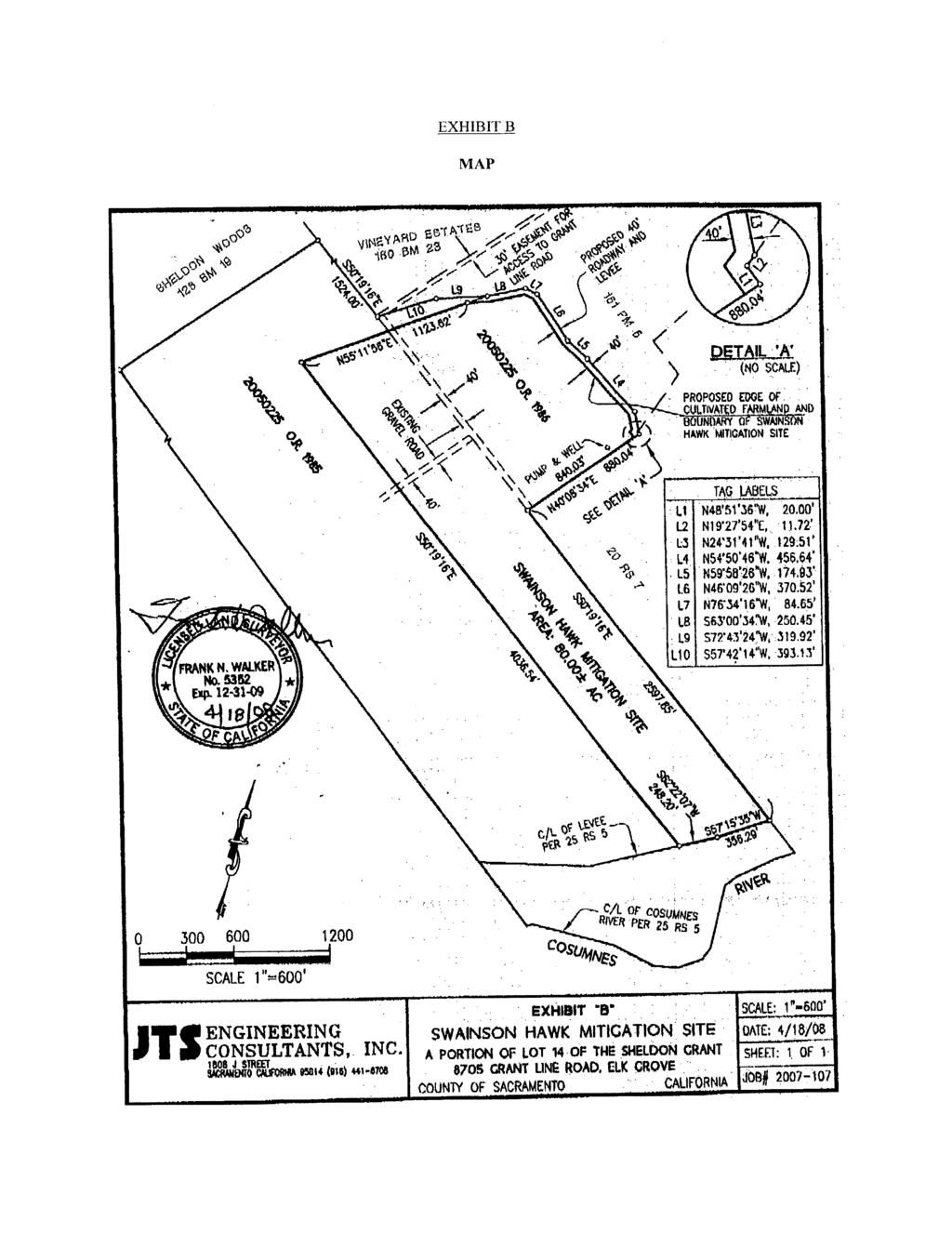
5 EASEMENT DOCUMENTATION REPORT 1. INTRODUCTION 1.1. PURPOSE The purpose of this report is to provide an accurate representation of the present condition of the Mohamed Property (property) as it relates to the easement language and restrictions as of the date of the recording (April 28, 2008) of the Conservation Easement. The property is named for Joseph Mohamed Sr., trustee of the Joseph Mohamed Sr. and Shirley M. Mohamed Charitable Remainder Unitrust II, who is listed as grantor on the Conservation Easement. The Conservation Easement for the property is attached as Appendix A. The Easement Documentation Report for Alhambra Farms, Sacramento County, California (EDR; Williams Wildland Consulting 2005) was used as a reference of the past conditions of the Alhambra Farms property, part of which (80 acres) is covered under the Conservation Easement and referred to as the Mohamed Property. The information and photographs provided herein represent the condition of the property as of February 11, LOCATION The property is located in south-central Sacramento County, to the southeast of the Elk Grove city limit southeast of the intersection at Grant Line Road and Wilton Road (Figure 1). The property is bordered by Deer Creek on the northwestern end and the Cosumnes River on the southeastern end (Figure 2). The property covered under the Conservation Easement is approximately 80 acres, which is contained within a single legal parcel, assessor parcel number (APN) METHODS A site visit to the property was conducted on February 11, 2009 by City of Elk Grove biologist, Jessica Griggs, to note features relevant to the Conservation Easement agreement and to take surface reference photos. On the day of the site visit, the weather was overcast with an outside temperature of approximately 50 degrees Fahrenheit (TWC 2009). United States Department of Agriculture (USDA) National Agricultural Imagery Program (NAIP) aerial photos (2005) and digitized parcel boundaries were used as references and as base layers for maps. Maps were created using ArcView software. City of Elk Grove February Easement Monitoring Report Mohamed Property
6 EASEMENT DOCUMENTATION REPORT This page is intentionally left blank. Easement Monitoring Report City of Elk Grove Mohamed Property February
7 BRADSHAW RD CHERRINGTON LN MECCA RD EXCELSIOR RD RILEY RD DAVIS RD T:\_GIS\Elk_Grove\MXDs\Swainsons Hawk Monitoring\Fig 1 - Mohamed Location.mxd - 11:07:39 AM AVE AVE City of Elk Grove BOND RD BADER RD PAVICH LN MACKEY RD CORFU DR GRANT LINE RD CLARK LAKE LN CALVINE RD MOONEY RD BEITZEL RD CHAMBEAU WAY GRENACHE WAY WILTON RD Project Site GREEN RD RANDOLPH RD OVE BLVD FREEMAN RD Grove City Limit Deer Creek MINDY LN FREEMAN RD GAY RD HAGGIE RD DILLARD RD MANN RD Cosumnes River WALMORT RD North Fork Badger Creek SALAS RD Miles Source: USDA FSA NAIP, 2005; City of Elk Grove, 2008 City of Elk Grove Development Services Figure 1 Location Map
8


9 T:\_GIS\Elk_Grove\MXDs\Swainsons Hawk Monitoring\2009\Fig 2 - Mohamed.mxd - 12:13:58 PM Lower Access Road Creek Crossing GRENACHE WAY CHAMBEAU WAY Upper Access Road Creek Crossing P3 P4 P1 P2 P5 D e e r C r e e k APN: Electric Well Pump MOONEY RD WILTON RD C o s u m n e s R i v e r CECATRA DR Legend Mohamed Property Source: USDA Dept of Agriculture NAIP, 2005; NRCS Soil Data Mart; City of Elk Grove RANCHERIA DR Feet City of Elk Grove Development Services Figure 2 Photo Station Locations
10
11 EASEMENT DOCUMENTATION REPORT Photographs of the property were taken with an 8.0 megapixel Nikon Coolpix L18 digital camera, five feet above the ground. Photos stations were recorded on an aerial photograph and digitized using ArcGIS software. Figure 2 shows the locations of the photo stations. A description of each photo station location and each scene photographed is included in Appendix B. Photo reference numbers start with the number of a fixed photo station (e.g., P1, P2), and are followed by a letter denoting the direction toward which the camera was pointed. For example, photo P1-S is a photo taken at photo station 1 looking toward the south, and P1-N is a photo taken from the same fixed location but looking toward the north. The geographic coordinates and a brief locality description for each photo station are found in Appendix C. 3. DESCRIPTION OF THE PROPERTY AND EASEMENT The property s legal description is provided in Exhibit A of the Conservation Easement, which is enclosed as Appendix A of this report. As mentioned previously, the property is approximately 80 acres. The property consists of one narrow, 50-acre portion of the parcel that is oriented in a northwest to southeast direction perpendicular to Deer Creek and a second 30-acre portion of the parcel that borders the 50-acre strip on the northwestern end of the property, as shown in Figure 2. The other characteristics of the property are described below under Sections 3.6 Infrastructure and Buildings and 3.7 Conservation Features. 3.1 PURPOSE OF THE CONSERVATION EASEMENT The multiple resource conservation purposes of the Conservation Easement are to preserve and protect in perpetuity (a.) the availability of the property for agriculture by protecting the property from development pressure; (b.) the conservation and habitat values of the property as foraging and/or nesting habitat for Swainson s hawks (Buteo swainsonii) and for other wildlife essential for maintaining Swainson s hawk habitat, including the processes which sustain that habitat; and (c.) the open space character of the property which is an important public benefit and is consistent with the availability of the property for wildlife habitat and agricultural uses (Appendix A). 3.2 SURROUNDING PROPERTIES As mentioned previously, the property is bordered by Deer Creek along the northwestern end and the Cosumnes River along the southeastern end (Figure 2). Directly to the northeast of the property, there are grape vineyards. To the southwest of the property there is the Cosumnes River and a portion of its undeveloped floodplain. The remainder of the surrounding land to the north and northeast of the property are predominately agricultural estates, a form of rural residential land use with parcels that are typically five to 20 acres in size. 3.3 HISTORIC AGRICULTURAL PRACTICES According to the 2005 EDR, the property was operated as a dairy up until the mid-1980s (Williams Wildland Consulting 2005). At this time, the farmland wherein the current 80-acre property boundary is located was used to grow alfalfa and grain to feed dairy cows. The dairy barn and main operations buildings were located in the upland areas north of Deer Creek, which is located outside of the current property boundary. Since the mid-1980s, the leveled farmland on the property has been traditionally planted with annual row or field crops, including tomatoes, sugar, beets, corn, beans, and grains such as wheat and barley (Williams Wildland Consulting 2005). City of Elk Grove February Easement Monitoring Report Mohamed Property
12 EASEMENT DOCUMENTATION REPORT 3.4 CURRENT AGRICULTURAL PRACTICES Nearly all of the farmland within the property has been leveled and planted with field crops. At the time of the February 11, 2009 site visit, the fields within the property had been recently disked and planted with a low-lying, grain-rye grass hybrid field crop that appeared to be about two to five inches tall (pers. comm. Mohamed 2009). Farm improvements include (a.) an irrigation system comprised of a 40 horsepower (hp) electric well pump, located along the southeastern edge of the 30-acre portion within the property (see photo P5-SE; Appendix B); (b.) underground concrete pipes for irrigation; and (c.) above ground power lines that connect the electric well pump to two other electric well pumps located offsite on an adjacent parcel to the southwest, which is under the same ownership as the Mohamed Property (pers. comm. Mohamed 2009). The remaining non-farmed acreage within the property includes a single interior dirt road that begins near the central-northwestern end of the property and continues through the center of the property along the edge between the 30-acre and the 50-acre portions of the property until it terminates at the southeastern end of the property at the levee (see photo P2-SE; Appendix B) CURRENT WATER USES Irrigation water is pumped from the electric well pump located on the southeastern edge of the 30-acre portion of the property and delivered to the fields via underground concrete piping found throughout the property (see photo P5-SE, Appendix B). Crops are irrigated above ground by means of flood, ditch, or sprinkler irrigation. Irrigation water is also occasionally pumped out of the Cosumnes River via a removable pump powered by a tractor power take-off (PTO). The current water uses are similar to what has been reported previously (Williams Wildland Consulting 2005). 3.6 INFRASTRUCTURE AND BUILDINGS Residences and Other Buildings There are no existing buildings on the property. Since the property is prone to seasonal flooding due to its location in the flood plains of Deer Creek and the Cosumnes River, the Conservation Easement does not allow any residences or human-occupied buildings on the property. The Conservation Easement allows for the maintenance, repair, replacement, or rebuilding of existing structures and improvements provided that such replacement structures/improvements shall be of the same square footage as the structures/improvements that they replace, shall be rebuilt in the same general location, and in a manner consistent with the purposes of the Conservation Easement. Currently, there are no plans to construct any new buildings on the property; therefore, the property is consistent with the requirements of the Conservation Easement. 3.7 FENCES AND ROADS As of the February 11, 2009 site visit, there are no fences on the property. There are two dirt roads, herein referred to as the upper and lower access roads, which provide outside vehicle access to the property (Figure 2). The lower access road is accessed from 9141 Mooney Road and the upper access road is accessed from 8705 Grant Line Road; both roads provide access to the northwestern end of the property and have low-water crossings at Deer Creek. The low-water creek crossings consist of concrete slabs overlying steel pipes. Easement Monitoring Report City of Elk Grove Mohamed Property February
13 EASEMENT DOCUMENTATION REPORT There are several unimproved dirt roads within and surrounding the property. A dirt road is located along the northwestern end of the property, which starts from the lower access road crossing at Deer Creek and terminates near the center of the northwestern edge of the 30-acre portion of the property. This road s terminus is denoted by photo station 5 on Figure 2. Another dirt road runs along the top of the levee adjacent to the Cosumnes River along the southeastern border of the property. Another interior dirt road starts from the northwestern end of the property, near photo station 2 (Figure 2), and terminates at the dirt road atop the levee adjacent to the Cosumnes River. This dirt road runs through the interior of the property along the edge between the 30-acre portion and the 50-acre portion of the property. This road is visible in the aerial photograph of the property, shown in Figure 2. The type, location and size of the roads observed within the property during the February 11, 2009 site visit are similar to what has been reported previously (Williams Wildland Consulting 2005). The property is consistent with the requirements of the Conservation Easement for fences and roads. 3.8 DITCHES AND CANALS There are a few shallow drainage ditches that carry water from the irrigated fields off of the property. The southeastern end of the property is the highest area of the property and so water runoff generally flows west and north into Deer Creek near the northwestern end of the property. The location and size of the drainage ditches observed within the property during the February 11, 2009 site visit are similar to what has been reported within the property previously (Williams Wildland Consulting 2005). The property is consistent with the requirements of the Conservation Easement for ditches and canals. 3.9 CONSERVATION FEATURES Riparian Corridors The northwestern and southeastern ends of the property are bordered by riparian corridors that are adjacent to Deer Creek and the Cosumnes River, respectively (Figure 2). The overstory of the Deer Creek riparian corridor is dominated by mature Valley oak (Quercus lobata), Oregon ash (Fraxinus latifolia), Fremont s cottonwood (Populus fremontii), box-elder (Acer negundo), and California black walnut (Juglans californica var. hindsii). The dominant understory species consist of poison-oak (Toxicodendron diversilobrum), wild grape (Vitis californica), Himalayan blackberry (Rubus discolor), California rose (Rosa californica) and poison hemlock (Conium maculatum). The overstory of the Cosumnes River riparian corridor consists of Valley oaks and several species of willow (Salix spp.), which are broadly spaced, allowing the riparian area to be generally more scrub-like in appearance. Both the Deer Creek and the Cosumnes River riparian corridors bordering the property provide suitable nesting habitat for Swainson s hawks due to the size and proximity of the large trees found within the riparian corridors to the farmed fields within the property. Generally, Swainson s hawks utilize nesting sites in large trees bordering open fields due to the availability of foraging opportunities and prey items in close proximity to their nesting sites. These riparian habitats also provide suitable foraging and cover habitat for a variety of wildlife species including prey items for Swainson s hawks. According to the 2005 EDR, Swainson s hawks were suspected of nesting in the large Valley oaks along Deer Creek near the northwestern end of the property (Williams Wildland Consulting 2005). As of the February 11, 2009 site visit, evidence of past nesting sites (i.e., stick nests) were not observed within the riparian corridor near Deer Creek. Although no nests were observed, the riparian corridors of Deer Creek and the Cosumnes River adjacent to the property provide suitable nesting habitat for Swainson s hawks. City of Elk Grove February Easement Monitoring Report Mohamed Property
14 EASEMENT DOCUMENTATION REPORT Influences Regarding Winter Role At the southeastern end of the property, there is a levee adjacent to the Cosumnes River that protects the property from seasonal flooding events; however, seasonal flooding has been known to occur in the northwestern end of the property due to seasonal inundation from Deer Creek (Williams Wildland Consulting 2005). Flood waters flowing across the northwestern end of the property have been known to cause substantial erosion and sediment loads (Williams Wildland Consulting 2005). Uplands, Trees, Cropland and Open Space Nearly all of the farmed land on the property has been leveled and planted with field crops. As of the February 11, 2009 site visit, the fields had been recently disked and planted with a grainrye grass hybrid field crop that appeared to be roughly two to five inches tall (pers. comm. Mohamed 2009). This low-lying field crop provides suitable foraging habitat for Swainson s hawks due to the high visibility and accessibility of prey items within the low ground cover. There is a row of trees lining the interior dirt road that runs down the center of the property from the northwestern end to the southeastern end, dividing the 30-acre portion of the property from the 50-acre portion of the property. These trees cannot fully develop because they are regularly trimmed to prevent damage to the powerlines that run alongside this dirt road. These trees do not provide suitable nesting sites for Swainson s hawk; however, suitable nesting habitat for Swainson s hawk was observed in the riparian corridors of Deer Creek and the Cosumnes River in the vicinity of the property, as described previously under the subheading Riparian Corridors above. 4. CONCLUSIONS 4.1 ADHERENCE TO THE EASEMENT REQUIREMENTS Review of the Conservation Easement (Appendix A) for the property revealed that the activities and practices observed during the site visit were permitted uses. The farming practices (grain-rye grass crop) observed during the February 11, 2009 site visit are allowed under the requirements of the Conservation Easement. The requirements set forth in the Conservation Easement state that no residences or humanoccupied buildings are permitted within the property because the property is prone to seasonal flooding due to its location within the flood plains of Deer Creek and the Cosumnes River. Currently, there are no plans to construct any buildings on the property; therefore, the property is in compliance with the requirements of the Conservation Easement. 4.2 QUALITY OF SWAINSON S HAWK FORAGING HABITAT WITHIN THE PROPERTY The property consists of high-quality foraging habitat for Swainson s hawks. The low-lying field crop provides excellent foraging habitat for Swainson s hawks because it allows for clear visibility and accessibility of prey items within the fields. In addition, according to the California Department of Fish and Game (CDFG) California Natural Diversity Database (CNDDB) records, there are 55 previously recorded occurrences of Swainson s hawks within a ten-mile radius of the property (CDFG 2009). Since numerous Swainson s hawk nests have been recorded in the surrounding area, it is reasonable to assume that Swainson s hawks nest in the vicinity of the property and could use the property as foraging habitat. In addition, the large oak, cottonwood and willow trees around the perimeter of the property (associated with the riparian corridors along Deer Creek and the Cosumnes River) represent suitable nesting habitat for Swainson s hawk. Easement Monitoring Report City of Elk Grove Mohamed Property February
15 EASEMENT DOCUMENTATION REPORT REFERENCES California Department of Fish and Game (CDFG) California Natural Diversity Database (CNDDB) Rarefind 3 computer program, Version Commercial version dated February 1, Data will expire August 1, CDFG, Biogeographic Data Branch. Sacramento, CA. Mohamed, Sr. Joseph Personal Communication during the February 11, 2009 site visit to the Mohamed Property. The Weather Channel (TWC) Today s Weather in Elk Grove, CA. Accessed on February 11, 2009 from Williams Wildland Consulting, Inc Easement Documentation Report for Alhambra Farms, Sacramento County, California. June 1, City of Elk Grove February Easement Monitoring Report Mohamed Property
16
17 APPENDICES
18
19 APPENDIX A CONSERVATION EASEMENT
20
21

22
23

24

25

26
27

28
29
30
31
32

33

34
35
36
37
38
39
40
41
42
43
44

45

46
47 APPENDIX B DOCUMENTATION PHOTOS
48


.")
49 APPENDIX B: DOCUMENTATION PHOTOS P1-NE: Low water crossing at Deer Creek. This is the upper access road. APPENDIX B: DOCUMENTATION PHOTOS P2-NE: South side of Deer Creek and surrounding riparian woodland on the left. P2-E: View of field planted with grass for hay production. P2-SE: View of utility line along dirt interior road that divides the 30-acre and 50-acre parcels. P3-S: View of field near the northern portion of the P2-SW: View of levee road along edge of Deer property, riparian corridor surrounding Cosumnes Creek (to the right). River is in the background. City of Elk Grove February 2009 B-1 Easement Monitoring Report Mohamed Property


50 APPENDIX B: DOCUMENTATION PHOTOS P3-N: View of water pump at Deer Creek to the southwest of the upper access road. P4-NE: View of low water crossing at Deer Creek. The upper access road is in the center. P4-SW: View of the south side of Deer Creek riparian P5-NE: View riparian woodland to the south of Deer woodland downstream to the southeast of the Creek and the edge of the field. upper access road. P5-S: View of recently disked field, planted with grain-rye grass hybrid field crop. P5-SE: View of recently disked field, planted with grain-rye grass hybrid field crop. Easement Monitoring Report City of Elk Grove Mohamed Property February 2009 B-2
51 APPENDIX B: DOCUMENTATION PHOTOS P5-SE: View of electric well pump on the edge of the P5-SW: View of the row of trees and electricity posts 30-acre portion of the property, located to the right that run between the 30-acre portion and the 50- of the electricity post. acre portion. P5-W: View of 30-acre portion of the property with the 50-acre portion in the background. City of Elk Grove February 2009 B-3 Easement Monitoring Report Mohamed Property
52
53 APPENDIX C PHOTO STATION COORDINATES AND LOCALITY NOTES
54
55 APPENDIX C: PHOTO STATION COORDINATES AND LOCALITY NOTES APPENDIX C: PHOTO STATION COORDINATES AND LOCALITY NOTES Photo Point UTM E(m) UTM N(m) Description P P P P P At the upper access road to the property, that crosses Deer Creek. At the northwestern end of the property, near the start of the interior dirt road (with the adjacent power line) that runs the length of the edge between the 30-acre and 50- acre portions of the property. At the northwestern corner of the property, taken from the dirt road adjacent to Deer Creek. At the northwestern end of the property, taken from the dirt road adjacent to Deer Creek. At the northwestern end of the property, taken at the terminus of the dirt road that runs along the majority of the property s northwestern end. City of Elk Grove February 2009 C-1 Easement Monitoring Report Mohamed Property
56
EASEMENT MONITORING REPORT. Mohamed Property. Sacramento County, California
 EASEMENT MONITORING REPORT Mohamed Property Sacramento County, California June 2012 Prepared by: Summer Pardo City of Elk Grove 8401 Laguna Palms Elk Grove, CA 95758 EASEMENT MONITORING REPORT TABLE OF
EASEMENT MONITORING REPORT. Reynen and Bardis Property. Sacramento County, California
 EASEMENT MONITORING REPORT Reynen and Bardis Property Sacramento County, California June 2012 Prepared by: Summer Pardo City of Elk Grove 8401 Laguna Palms Elk Grove, CA 95758 EASEMENT MONITORING REPORT
EASEMENT DOCUMENTATION REPORT: CARLI PROPERTY
 EASEMENT DOCUMENTATION REPORT: CARLI PROPERTY SACRAMENTO COUNTY, CALIFORNIA June 8, 2010 Prepared by: Angela Calderaro City of Elk Grove 8401 Laguna Palms Elk Grove, CA 95758 EASEMENT DOCUMENTATION REPORT
EASEMENT DOCUMENTATION REPORT: July 7, 2010
 EASEMENT DOCUMENTATION REPORT: ACTERRA/AVIS PROPERTY SACRAMENTO COUNTY, CALIFORNIA July 7, 2010 Prepared by: Angela Calderaro City of Elk Grove 8401 Laguna Palms Elk Grove, CA 95758 EASEMENT DOCUMENTATION
EASEMENT DOCUMENTATION REPORT: April 2011
 EASEMENT DOCUMENTATION REPORT: ACTERRA/AVIS PROPERTY SACRAMENTO COUNTY, CALIFORNIA April 2011 Prepared by: Angela Calderaro City of Elk Grove 8401 Laguna Palms Elk Grove, CA 95758 EASEMENT DOCUMENTATION
EASEMENT MONITORING REPORT. Kirkham Property. Sacramento County, California
 EASEMENT MONITORING REPORT Kirkham Property Sacramento County, California June 2012 Prepared by: Summer Pardo City of Elk Grove 8401 Laguna Palms Elk Grove, CA 95758 EASEMENT MONITORING REPORT TABLE OF
EASEMENT MONITORING REPORT. Acterra/Avis Property. Sacramento County, California
 EASEMENT MONITORING REPORT Acterra/Avis Property Sacramento County, California June 2012 Prepared by: Summer Pardo City of Elk Grove 8401 Laguna Palms Elk Grove, CA 95758 EASEMENT MONITORING REPORT TABLE
EASEMENT DOCUMENTATION REPORT: KIRKHAM FARM
 EASEMENT DOCUMENTATION REPORT: KIRKHAM FARM SACRAMENTO COUNTY, CALIFORNIA April 5, 2011 Prepared by: Daniel Neal City of Elk Grove 8401 Laguna Palms Elk Grove, CA 95758 EASEMENT DOCUMENTATION REPORT TABLE
EASEMENT DOCUMENTATION REPORT: KIRKHAM FARM. Sacramento County, California
 EASEMENT DOCUMENTATION REPORT: KIRKHAM FARM Sacramento County, California March 6, 2009 Prepared by: Jessica Griggs City of Elk Grove 8401 Laguna Palms Elk Grove, CA 95758 EASEMENT DOCUMENTATION REPORT
Yolo County Habitat/Natural Community Conservation Plan Joint Powers Agency
 Yolo County Habitat/Natural Community Conservation Plan Joint Powers Agency ~ Partnering for Conservation ~ Member Agencies County of Yolo City of Davis City of Winters City of West Sacramento City of
JORDAO PROPERTY ± RIPARIAN IRRIGATED CROPLAND. $2,438,000 ($23,000/Acre)
") JORDAO PROPERTY ±106.00 RIPARIAN IRRIGATED CROPLAND Located at: 7505 Hogin Road Crows Landing, Stanislaus County, CA 95313 APN s 057-026-009 & 057-026-008 Offered for $2,438,000 ($23,000/Acre) Presented
JORDAO PROPERTY ±106.00 RIPARIAN IRRIGATED CROPLAND Located at: 7505 Hogin Road Crows Landing, Stanislaus County, CA 95313 APN s 057-026-009 & 057-026-008 Offered for $2,438,000 ($23,000/Acre) Presented
LAND AUCTION.
 LAND AUCTION 919+/- Acre Farm Charles Mix County, South Dakota Offered in Eight Tracts! Friday, December 7, 2018 1:30 PM at the National Guard Armory Building 610 East SD Highway 46, Wagner, South Dakota
A Comparison of Swainson s Hawk Conservation Easements. County of Sacramento City of Elk Grove. Summary Report
 A Comparison of Swainson s Hawk Conservation Easements County of Sacramento City of Elk Grove Summary Report Shannon McClure Summer 2010 Purpose Sacramento County and its cities have implemented Swainson
Conceptual Scheme SE W4
 December 2012 1. PURPOSE 1.1. The purpose of a Conceptual Scheme (CS) is as follows: a) To provide a framework for the subsequent subdivision and/or development of land within the Country Residential Policy
Cox Ranch, 1,726 +/- Acres
 AG-LAND Investment Brokers 275 Sale Lane Red Bluff, CA 96080 530-529-4400 Fax 530-527-5042 Cox Ranch, 1,726 +/- Acres Paskenta, CA Tehama County, CA i AG-LAND INVESTMENT BROKERS 275 Sale Lane, Suite
Whiskey Creek 360 $650,000. For SALE. Upper Whiskey Creek Road Walla Walla County, Washington. Associated Appraisers of Walla Walla LLC
 For SALE Associated Appraisers of Walla Walla LLC Whiskey Creek 360 $650,000 362.96 total acres Cropland 144.13 acres Timber and Range 218.83 acres Elk & Native Game Habitat AssociatedAppraisersofWW.com
Claudia Stuart, Williamson Act Program Manager and Nick Hernandez, Planning Intern
 Land Conservation (Williamson) Act Advisory Committee STAFF REPORT September 15, 2014 Prepared by: Claudia Stuart, Williamson Act Program Manager and Nick Hernandez, Planning Intern Subject: Discussion:
Foley Estate Farm. 80± Acres, Section 22 Grove Township Humboldt County, Iowa. August 27, 2015, 10:00 AM Humboldt County Fairgrounds Humboldt, Iowa
 Foley Estate Farm 80± Acres, Section 22 Grove Township Humboldt County, Iowa August 27, 2015, 10:00 AM Humboldt County Fairgrounds Humboldt, Iowa 1309 1 st Ave South, Suite 5 Fort Dodge, IA 50501-4954
FOR SALE 2, /- Gross Acre Cattle Ranch in Tulare County
 FOR SALE 2,252.70 +/- Gross Acre Cattle Ranch in Tulare County Morgan Houchin 3430 Unicorn Road Bakersfield, CA 93308 Neither the Seller, nor makes any representations or warranties, either expressed or
Pavillion, Fremont County, Wyoming
 Pavillion, Fremont County, Wyoming 58 E. Benteen Street Buffalo, WY 82834 Ph 307-684-9556 Toll Free 888-684-9557 Fax 307-684-8565 Email: info@pearsonrealestate.com Website: www.pearsonrealestate.com Location
MINERAL COUNTY PLANNING STAFF FINDINGS OF FACT Proposed Elk Run at St. Regis. February 12, 2017
 MINERAL COUNTY PLANNING STAFF FINDINGS OF FACT Proposed The proposed is a five-lot subdivision and is located approximately one mile east of St. Regis on Old Highway 10 East. The property is located in
Appendix H REPETITIVE LOSS PLAN
 Appendix H REPETITIVE LOSS PLAN Sacramento County Appendix H.1 Local Hazard Mitigation Plan Update August 2011 AREA #1 DRY CREEK Elkhorn Blvd East of Rio Linda Blvd PAST FLOOD EVENTS: MAY 1983; FEBRUARY
COUNTY OF SACRAMENTO CALIFORNIA
 COUNTY OF SACRAMENTO CALIFORNIA Control No.: PLNP2007-00537 Type: PMR TO: FROM: SUBJECT: SUBDIVISION REVIEW COMMITTEE PLANNING AND COMMUNITY DEVELOPMENT DEPARTMENT CHRIS BOTTIMORE TENTATIVE PARCEL MAP
Foley Estate FARM ± Acres, Section 15 Grove Township Humboldt County, Iowa. August 27, 2015, 10:00 AM Humboldt County Fairgrounds Humboldt, Iowa
 Foley Estate FARM 176.7± Acres, Section 15 Grove Township Humboldt County, August 27, 2015, 10:00 AM Humboldt County Fairgrounds Humboldt, 1309 1 st Ave South, Suite 5 Fort Dodge, IA 50501-4954 Phone:
Georgia Conservation Tax Credit Program Frequently Asked Questions
 Georgia Conservation Tax Credit Program Frequently Asked Questions What are the minimum requirements for eligibility under the Georgia Conservation Tax Credit Program (GCTCP)? Individual and corporate
Local Agriculture Perspectives in the Middle Rio Grande Valley
 Local Agriculture Perspectives in the Middle Rio Grande Valley Cecilia Rosacker-McCord Executive Director, Rio Grande Ag Land Trust Socorro Valley Farmer Land & Water Planning in the Middle Valley Friday,
center ridge ranch An agricultural and recreational investment opportunity.
 offered for sale center ridge ranch An agricultural and recreational investment opportunity. 891.0 (+/-) total acres Conway County, Arkansas offered by Licensed in Arkansas, Louisiana, Mississippi, Tennessee
Conceptual Scheme SE W4
 Conceptual Scheme September 2014 Conceptual Scheme 1. PURPOSE 1.1. The purpose of a Conceptual Scheme (CS) is as follows: a) To provide a framework for the subsequent subdivision and/or development of
Tracie & Dennis Jones Rezone, RZ
 / Planning and Zoning Staff Report Tracie & Dennis Jones Rezone, RZ2018-0014 Applicant: Tracie & Dennis Jones Staff: Deb Root, 454-7340 droot@canyonco.org Tax ID: R37886012 Current Zone: A (Agricultural)
For Office Use Only. Permit No. Fee: $ $ per proposed lot (AN ADDITIONAL 10% CODE COMPLIANCE FEE WILL BE CHARGED)
") For Office Use Only Permit No. Fee: $1600 + $560.00 per proposed lot (AN ADDITIONAL 10% CODE COMPLIANCE FEE WILL BE CHARGED) LAND PARTITION FOREST (Conditional Use) Crook County Planning Department 300
For Office Use Only Permit No. Fee: $1600 + $560.00 per proposed lot (AN ADDITIONAL 10% CODE COMPLIANCE FEE WILL BE CHARGED) LAND PARTITION FOREST (Conditional Use) Crook County Planning Department 300
Old Thomasson Range, Chico, CA
 AG-LAND INVESTMENT BROKERS 275 Sale Lane, Suite 2 / P. O. Box 896 Red Bluff, CA 96080 530.529.4400 office / 530.527.5042 fax Old Thomasson Range, Chico, CA Property: Approximately 5,270 acres bordered
Planning Commission Staff Report August 4, 2016
 Planning Commission Staff Report PROJECT: Ermandarold Estates TSM Extension FILE: EG-07-128A REQUEST: Tentative Subdivision Map Extension LOCATION: 8577 Bader Road APN: 122-0230-001, 003, 004, 005, 006
No November MICHIGAN LAND VALUES by. Steven D. Hanson, Professor Gerald Schwab, Professor
 Agricultural Economics Report No. 604 November 2000 2000 MICHIGAN LAND VALUES by Steven D. Hanson, Professor Gerald Schwab, Professor Department of Agricultural Economics MICHIGAN STATE UNIVERSITY East
Planning Commission Staff Report
 Planning Commission Staff Report Project: Summary Vacation of a Drainage Easement for a Drainage Canal or Ditch over the Apple Computer Inc. Campus Property Finding of Consistency with the General Plan
Wood River Land Trust Staff Report
 Wood River Land Trust Staff Report Date: July 9, 2014 To: Board of Directors From: Staff, Keri York Regarding: MacConnell Agricultural Lands Easement Action Item Action Item: The item for consideration
Diamond Falls Subdivision PROPOSED YELLOWSTONE COUNTY BOARD OF PLANNING FINDINGS OF FACT
 Diamond Falls Subdivision PROPOSED YELLOWSTONE COUNTY BOARD OF PLANNING FINDINGS OF FACT The City/County Planning Staff has prepared the Findings of Fact for the Diamond Falls Subdivision. These findings
QUIET HILLS RANCH 3,871 + ACRES CONTACT:
 QUIET HILLS RANCH 3,871 + ACRES CONTACT: BILL WRIGHT or BILL QUINN SHASTA LAND SERVICES, INC. 358 Hartnell Avenue, Suite C Redding, CA 96002 (530) 221-8100 www.ranch-lands.com QUIET HILLS RANCH LOCATION:
Historic Reise Farm Puyallup, Pierce County, Washington Request for Proposals
 Historic Reise Farm Puyallup, Pierce County, Washington Request for Proposals Background and Information Thank you for your interest in the historic Reise Farm, located near the city of Orting in Pierce
ZONING PERMIT APPLICATION
 ZONING PERMIT APPLICATION OFFICE USE ONLY Date Received: FILE NO. 120 DAY EXPIRATION Purpose: Some types of land use activities listed in the Lake County Zoning Ordinance are allowed to occur with a minimal
PRE-PROPOSAL for the NYS Farmland Protection Implementation Grant Program
 DEBORAH MATURO Clerk ONDAGA COUNTY AGRICULTURE AND FARMLAND PROTECTION BOARD 407 Court House Syracuse, NY 13202 Phone: 315/435-2070 BRIAN REEVES Chairman Onondaga County Agriculture & Farmland Protection
Mike Eliason, Owner Monday February 18 th 2019 Sale Time: 10:30 AM /- Acres, Lincoln County, SD Auctioneers: Joel R. Westra ,
 Mike Eliason, Owner Monday February 18 th 2019 Sale Time: 10:30 AM 187.99 +/- Acres, Lincoln County, SD Auctioneers: Joel R. Westra 605-310-6941, Pete Atkins 605-351-9847 Joel A. Westra 605-957-5222, Craig
FOR SALE. Hawkins Road North 78 / Vacaville, CA. 78 Acres / $1,650, Katleba Lane, Vacaville, CA APN s: & 030
 78 Acres / $1,650,000 6268 Katleba Lane, Vacaville, CA 95687 APN s: 0134-300-020 & 030 Property Highlights y Great Land Bank Opportunity y Prime Farmland in the Path of Growth PROPERTY y Within Solano
APPLICATION SUBMITTAL REQUIREMENTS FOR Tentative Parcel or Subdivision Maps
 CITY OF EL CERRITO Community Development Department Planning and Building Division 10890 San Pablo Avenue, El Cerrito, CA 94530 (510) 215-4330 FA (510) 233-5401 planning@ci.el-cerrito.ca.us APPLICATION
LLC & MLLC Property Bismark Meadows Bonner County, Idaho
 Vital Ground Property Management Plan LLC & MLLC Property Bismark Meadows Bonner County, Idaho December 10, 2009 (updated 2/12/13) Ryan Lutey The Vital Ground Foundation Building T-2, Fort Missoula Road
RENITA HURDSMAN BEAR RIVER STATE PARK LAND EXCHANGE PROPOSAL
 DETAILED ANALYSIS RENITA HURDSMAN BEAR RIVER STATE PARK LAND EXCHANGE PROPOSAL June 1, 2006 Prepared by the Office of State Lands and Investments Herschler Building, 3W 122 West 25 th Street Cheyenne,
offered for sale UPPER RAFT CREEK RESERVE A recreational investment opportunity offered by
 offered for sale UPPER RAFT CREEK RESERVE A recreational investment opportunity 241.0 (+/-) total acres White County, Arkansas offered by Licensed in Arkansas, Louisiana, Mississippi, Tennessee and Texas
House, Buildings and 28 Acres m/l Keokuk County, IA. Underwood Property County Road V5G, Ollie, Iowa 52576
 ACREAGE FOR SALE House, Buildings and 28 Acres m/l Keokuk County, IA Underwood Property 28593 County Road V5G, Ollie, Iowa 52576 Property Information Location From Sigourney: 2 miles south on Hwy 149,
DAUPHIN CREEK ESTATES SUBDIVISION
 # 12 SUB-000076-2017 DAUPHIN CREEK ESTATES SUBDIVISION Engineering Comments: FINAL PLAT COMMENTS (should be addressed prior to submitting the FINAL PLAT for review and/or signature by the City Engineer):
Hickory Ridge Residence & Farm An residential, agricultural, and recreational investment opportunity.
 offered for sale Hickory Ridge Residence & Farm An residential, agricultural, and recreational investment opportunity. 2,620 (+/-) square foot dwelling situated on 65 (+/-) acres of farmland Hickory Ridge,
Onondaga County Agriculture & Farmland Protection Board PRE-PROPOSAL for the NYS Farmland Protection Implementation Grant Program
 DEBORAH MATURO Clerk ONDAGA COUNTY AGRICULTURE AND FARMLAND PROTECTION BOARD 407 Court House Syracuse, NY 13202 Phone: 315/435-2070 BRIAN REEVES Chairman Onondaga County Agriculture & Farmland Protection
CONDITIONAL USE PERMIT Application Packet
 CONDITIONAL USE PERMIT Application Packet Community Development Department 1020 East Pioneer Road, Draper, UT 84020 (801) 576-6539 Fax (801) 576-6526 Dear Applicant, This application packet has been developed
OPEN-SPACE CONVERSION REQUEST
 OPEN-SPACE CONVERSION REQUEST Applicant: Board Meeting: February 9, 2017 Landowner: Normandy Capital, LLC VOF Easement: BAT-03678 Table of Contents: Cover Page 1 Table of Contents 2 Application Overview
Glad Valley Ranch North Unit
 Glad Valley Ranch North Unit Glad Valley, Ziebach County, SD 1,887.07 Acres $1,790,000.00 Executive Summary: The Glad Valley Ranch is located in one contiguous 3,678.15 Deeded acre block in Northern Ziebach
Sample Baseline Documentation Report (BDR) Annotated Template for Environmentally Important Land
 Annotated Template for Environmentally Important Land") Sample Baseline Documentation Report (BDR) Annotated Template for Environmentally Important Land The baseline documentation report (BDR) provides a snap shot of the biophysical condition of a property
Sample Baseline Documentation Report (BDR) Annotated Template for Environmentally Important Land The baseline documentation report (BDR) provides a snap shot of the biophysical condition of a property
PERMITTED ACTS and RURAL ENTERPRISES
 PERMITTED ACTS and RURAL ENTERPRISES Pennsylvania s Agricultural Area Security Law, known as Act 43, 3 P.S. 901. et seq., and the Regulations promulgated thereunder by the Pennsylvania Department of Agriculture
JAIL SITE ASSESSMENT PICKETT COUNTY, TENNESSEE. For MARCH 2016
 JAIL SITE ASSESSMENT For PICKETT COUNTY, TENNESSEE MARCH 2016 JAMES C. HAILEY & COMPANY Consulting Engineers 7518 Highway 70 South Suite 100 Nashville, Tennessee 37221 (615) 883-4933 JAIL SITE ASSESSMENT
IMPROVED LAND FOR SALE OR GROUND LEASE
 IMPROVED LAND FOR SALE OR GROUND LEASE SUBJECT Sheldon Town Center ± 4.5 Acre Parcel Excellent Development Opportunity $2,491,850 ($12.50 PSF) Grant Line and Wilton Development Opportunity 8973 Grant Line
APPLICATION PROCESSING. CHECK WITH STAFF - Development Services Staff will explain the requirements and procedures to you.
 PLANNED DEVELOPMENT ZONE 1810 E. HAZELTON AVENUE, STOCKTON CA 95205 BUSINESS PHONE: (209) 468-3121 Business Hours: 8:00 a.m. to 5:00 p.m. (Monday through Friday) STEP 1 STEP 2 FEE FORM DEED SERVICES APPLICATION
CITY OF RIALTO PLANNING DIVISION
 ENTITLEMENT APPLICATION LEGAL OWNER PROPERTY INFORMATION: I hereby certify that I am (we are) the record owner(s) for property tax assessment purposes of the property encompassed by this application. I
TOWN OF PELHAM, NEW HAMPSHIRE
 TOWN OF PELHAM, NEW HAMPSHIRE BUILDOUT ANALYSIS Prepared for the PELHAM CONSERVATION COMMISSION with the assistance of the NASHUA REGIONAL PLANNING COMMISSION TABLE OF CONTENTS I. INTRODUCTION...1 II.
CITY OF RIALTO PLANNING DIVISION ENTITLEMENT APPLICATION
 ENTITLEMENT APPLICATION LEGAL OWNER INFORMATION: I hereby certify that I am (we are) the record owner(s) for property tax assessment purposes of the property encompassed by this application. I understand
$795,000 ALL CASH or TERMS ACCEPTABLE TO SELLER
 30.40 Acres Devoted to Irrigated Cropland Located at: North Side of Ave. 1, Atwater, Merced County, CA Offered for $795,000 ALL CASH or TERMS ACCEPTABLE TO SELLER Presented By: Edwards, Lien & Toso, Inc.
Glad Valley Ranch. Executive Summary: Glad Valley, SD Corson & Ziebach Counties 5, Deeded Acres and 723 Lease Acres $4,950,000.
 Glad Valley Ranch Glad Valley, SD Corson & Ziebach Counties 5,943.85 Deeded Acres and 723 Lease Acres $4,950,000.00 Executive Summary: The Glad Valley Ranch is located in one contiguous 5,943.85 deeded-acre
IMPROVED LAND FOR SALE OR GROUND LEASE
 IMPROVED LAND FOR SALE OR GROUND LEASE 8973 Grant Line Road Elk Grove CA 95624 ± 4.5 Acre Parcel Sheldon Town Center Excellent Development Opportunity $1,875,000 ($9.40 PSF) Exclusively Listed By: 916.
Farmland for Sale. Bleckley County, Georgia. $1,002, Acres $2,650 per Acre
 Farmland for Sale Bleckley County, Georgia 2 Contents Property Fact Sheet... 3 Regional Map... 4 Local Map... 5 Aerial Map... 6 FSA - Farm 2044 Tract 859... 7 FSA - Farm 2044 Tract 613... 8 Farmland Utilization...
RECITALS. B. WHEREAS, Ranch, its successors and assigns, are referred to in the Easement as the Grantor ; and
 Basic Components of Management Plans Associated with Conservation Easement Acquisitions Where A Land Trust Or other third party Is the Grantee April 17, 2012 Key: Text in normal font, without highlight,
Trousdale R-1 Permit Planning Review Application
 Application Overview: Trousdale R-1 Permit Planning Review Application City of Beverly Hills Community Development Department Planning Division 455 N. Rexford Drive Beverly Hills, CA 90210 Tel. (310) 285-1141
Monday, December 19, 2016
 LAND AUCTION 412.34 ± Acres in Three Parcels Sloan and Lake Townships, Woodbury & Monona County, Iowa Sellers: Robert P. Friis Trust Robert Michael Friis, Trustee Gertrude F. Friis Estate Robert Michael
Alberta Conservation Association 2015/16 Program Summary Report
 Project Name: Landowner Habitat Program Alberta Conservation Association 2015/16 Program Summary Report Land Management Program Manager: Darren Dorge Project Leader: Ed Kolodychuk Primary ACA staff on
CITY OF WINTERS HABITAT MITIGATION PROGRAM
 CITY OF WINTERS HABITAT MITIGATION PROGRAM The City currently faces oversight of the implementation of various habitat mitigation requirements associated with recently approved and pending development
CITY OF CORNING TENTATIVE MAPS
 CITY OF CORNING TENTATIVE MAPS APPLICANT S GUIDE TO PROCEDURES WHAT IS A TENTATIVE MAP? A division of land for the purpose of sale, lease, or finance requires submittal of a map for City approval showing
FLORIDA DEPARTMENT OF AGRICULTURE AND CONSUMER SERVICES
 FLORIDA DEPARTMENT OF AGRICULTURE AND CONSUMER SERVICES Office of Agricultural Water Policy Mayo Building 407 South Calhoun Street Tallahassee, Florida 32399 Binding Determination Florida Statute 373.406(2);
FOR SALE /- Acres of Farmland & Almonds in Rosedale-Rio Bravo Water Storage District. Morgan Houchin. Tech Ag Financial Group, Inc.
 FOR SALE Morgan Houchin P.O. Box 98 Buttonwillow, CA 93206 Neither the Seller, nor makes any representations or warranties, either expressed or implied as to the accuracy or completeness of the enclosed.
Whiteman Ranch, Red Bluff, CA
 AG-LAND INVESTMENT BROKERS 275 Sale Lane, Suite 2 / P. O. Box 896 Red Bluff, CA 96080 530.529.4400 office / 530.527.5042 fax Whiteman Ranch, Red Bluff, CA Listing Price: $2,895,000 approximately $1,026
Yolo Habitat Conservancy County of Yolo City of Davis City of Winters City of West Sacramento City of Woodland University of California, Davis
 Yolo Habitat Conservancy County of Yolo City of Davis City of Winters City of West Sacramento City of Woodland University of California, Davis Science & Technical Advisory Committee (STAC) Operational
COUNTY OF SACRAMENTO CALIFORNIA PLANNING COMMISSION REPORT
 COUNTY OF SACRAMENTO CALIFORNIA PLANNING COMMISSION REPORT For the Agenda of: September 12, 2016 To: From: Subject: County Planning Commission Department Of Community Development PLNP2016-00179. Willman
HEADQUARTERS WEST LTD.
 HEADQUARTERS WEST LTD. FARM, RANCH, AGRIBUSINESS REAL ESTATE SALES & SERVICES Offered For Sale STATE OF ARIZONA AGRICULTURAL LEASEHOLD INTEREST 3,480± Cropland Acres/5,100± Gross Acres Yuma Mesa, Yuma
Farmland Sales Specialists
 Farmland Sales Specialists Setting the trend for how Real Estate is sold in the Midwest. www.barnesrealty.com 18156 Hwy 59 Mound City, MO 64470 (660) 442-3177 1711 Oregon Hiawatha, KS 66434 (785) 742-4580
Community Development Department Planning Division 1600 First Street + P.O. Box 660 Napa, CA Napa (707)
") Community Development Department Planning Division 1600 First Street + P.O. Box 660 Napa, CA 94559-0660 Napa (707) 257-9530 PLANNING COMMISSION STAFF REPORT JUNE 16, 2016 AGENDA ITEM # 6.B. 16-0056-EXT;
Community Development Department Planning Division 1600 First Street + P.O. Box 660 Napa, CA 94559-0660 Napa (707) 257-9530 PLANNING COMMISSION STAFF REPORT JUNE 16, 2016 AGENDA ITEM # 6.B. 16-0056-EXT;
direct Principal
 FARMLAND AVAILABLE FOR SALE ARVIN-EDISON OPEN LAND & CITRUS KERN COUNTY CA PROPERTY HIGHLIGHTS Open Ground and Mature Citrus Arvin-Edison Water District Quality Soils For More Information, Contact: MICHAEL
LAND AUCTION. Productive Irrigated and Dry Cropland Farms Offered in Five Tracts!
 LAND AUCTION 1,237+/- Acres Sedgwick County, Colorado and Deuel County, Nebraska Thursday, February 16, 2017 10:00 AM at the Julesburg Fire Hall Meeting Room 510 East First Street, Julesburg, Colorado
OPEN SPACE & RECREATION PLAN
 OPEN SPACE & RECREATION PLAN HOPEWELL TOWNSHIP Cumberland County, New Jersey Prepared by: Hopewell Township Environmental Commission Final October 2011 (THIS PAGE INTENTIONALLY LEFT BLANK) PUBLIC MEETINGS
OFFERING CIRCULAR. 146 Acre Container Farm Irrigated. Presented by:
 OFFERING CIRCULAR 146 Acre Container Farm Irrigated Presented by: The information contained in this offering circular was provided to Agri-Investment Services Group of Berkshire Hathaway NW Real Estate
Farmland for Cash Rent Bid
 Farmland for Cash Rent Bid 106 Acres (84.1% Tillable) Woodstock Township Schuyler County, Illinois For Information Contact: Christopher M. Flynn Edwards Group LLC 3223 South Meadowbrook Road, Suite A Springfield,
BEAR HAMMOCK GAME HAVEN
 COLDWELL BANKER COMMERCIAL SAUNDERS REAL ESTATE BEAR HAMMOCK GAME HAVEN EUSTIS, FL LAKE COUNTY 45 ± ACRES TOTAL 3 PURCHASING OPTIONS AVAILABLE SREland.com/BearHammock Carson Futch 863.216.5913 COLDWELL
DRAFT FOR PUBLIC HEARING (rev. March, 2016)
") Chapter 200. ZONING Article VI. Conservation/Cluster Subdivisions 200-45. Intent and Purpose These provisions are intended to: A. Guide the future growth and development of the community consistent with
Chapter 200. ZONING Article VI. Conservation/Cluster Subdivisions 200-45. Intent and Purpose These provisions are intended to: A. Guide the future growth and development of the community consistent with
FOR SALE FARMLAND AVAILABLE ACRES WHEELER RIDGE RD KERN COUNTY CA
 FARMLAND AVAILABLE FOR SALE WHEELER RIDGE RD KERN COUNTY CA PROPERTY HIGHLIGHTS Premium early ground Arvin-Edison Water District Available for permanant crop development Almonds, citrus, and vineyards
LOGAN COUNTY ACREAGE & PASTURE LAND AUCTION
 LOGAN COUNTY ACREAGE & PASTURE LAND AUCTION W/RESERVE Wednesday, April 2, 2014-10:30 am, MT Reck Agri Auction Center - 535 E. Chestnut, Sterling CO 1,088 +/- Acres - Logan County, CO 10 Parcels - 3 Combos
/- Acres Lincoln County, Minnesota. Pifer s LAND AUCTION. Wednesday, May 2, :00 a.m.
 342.33 +/- Acres Lincoln County, Minnesota LAND AUCTION Wednesday, May 2, 2018 11:00 a.m. AUCTION LOCATION: Senior Citizens Center - Taunton, MN Owner: Secured Lender Highly productive cropland in Lake
±86 ACRES OF LAND EL CENTRO ROAD & SAN JUAN SACRAMENTO, CA CONTACT US FOR SALE. SITE
 SACRAMENTO, CA 95834 SITE CONTACT US RANDY GRIMSMAN Senior Vice President Lic. 00857338 +1 916 446 8745 randall.grimsman@cbre.com www.cbre.com/randall.grimsman CBRE, Inc. 500 Capitol Mall, Suite 2400 Sacramento,
Larimer County Planning Dept. Procedural Guide for 1041 PERMITS
 - Larimer County Planning Dept. Procedural Guide for 1041 PERMITS PLEASE NOTE: A PRE-APPLICATION CONFERENCE IS REQUIRED PRIOR TO SUBMITTING THIS APPLICATION. PURPOSE: State Statutes allow local governments
offered for sale BAPTIST HEALTH FARM An Agricultural and Recreational Investment Opportunity offered by
 offered for sale BAPTIST HEALTH FARM An Agricultural and Recreational Investment Opportunity 217 (+/-) Total Acres Jefferson County, Arkansas offered by Licensed in Arkansas, Louisiana, Mississippi, Tennessee
FOR SALE /- Gross Acres El Rancho Farms Property. Morgan Houchin Tech Ag Financial Group, Inc
 FOR SALE 817.34 +/- Gross Acres Morgan Houchin 3430 Unicorn Road Bakersfield, CA 93308 Neither the Seller, nor makes any representations or warranties, either expressed or implied as to the accuracy or
Kent/MSU Extension Attn: Stacy Byers 775 Ball Ave NE Grand Rapids, MI Tel: (616)
") 2017 KENT COUNTY PURCHASE OF DEVELOPMENT RIGHTS (PDR) PROGRAM Kent/MSU Extension Attn: Stacy Byers 775 Ball Ave NE Grand Rapids, MI 49503 Email: stacy@sheridanland.com Tel: (616) 632-7878 FOR OFFICIAL
2017 KENT COUNTY PURCHASE OF DEVELOPMENT RIGHTS (PDR) PROGRAM Kent/MSU Extension Attn: Stacy Byers 775 Ball Ave NE Grand Rapids, MI 49503 Email: stacy@sheridanland.com Tel: (616) 632-7878 FOR OFFICIAL
CITY OF FAYETTEVILLE, ARKANSAS FINAL PLAT FOR STAFF USE ONLY FINAL PLAT FEE: $ $ Date Application Submitted: Date Accepted as Complete:
 CITY OF FAYETTEVILLE, ARKANSAS FINAL PLAT FOR STAFF USE ONLY FINAL PLAT FEE: $200.00-$800.00 Date Application Submitted: Date Accepted as Complete: Project Number: Public Hearing S-T-R: PP#: Zone: Please
THE CITY OF MOBILE, ALABAMA
 THE CITY OF MOBILE, ALABAMA LE 'I IER OF DECISION Kimberly Clark Mobile Operations 200 Africatown Blvd. Prichard, AL 36610 Re: 100 & 200 Africatown Boulevard (Northeast corner of Bay Bridge Road and Paper
STATE TAX COMMISSION QUALIFIED AGRICULTURAL PROPERTY EXEMPTION GUIDELINES
 STATE TAX COMMISSION QUALIFIED AGRICULTURAL PROPERTY EXEMPTION GUIDELINES Issued by the State Tax Commission August 2018 Table of Contents What is the Qualified Agricultural Exemption?... 2 How does Property
Chapter SWAINSON S HAWK IMPACT MITIGATION FEES
 The Swainson s Hawk ordinance can also be viewed online at: http://qcode.us/codes/sacramentocounty/ Once at the website, click on Title 16 BUILDINGS AND CONSTRUCTION, then Chapter 16.130 SWAINSON S HAWK
610 LAND DIVISIONS AND PROPERTY LINE ADJUSTMENTS OUTSIDE A UGB
 ARTICLE VI: LAND DIVISIONS AND PROPERTY LINE ADJUSTMENTS VI-21 610 LAND DIVISIONS AND PROPERTY LINE ADJUSTMENTS OUTSIDE A UGB 610-1 Property Line Adjustments (Property Line Relocation) A property line
Spirit Lake North, LLC
 BONNER COUNTY PLANNING DEPARTMENT PLANNING AND ZONING COMMISSION STAFF REPORT FOR March 1, 2018 Project Name: Amendment & Zone Change: Spirit Lake North, LLC File Number,Type: AM 162-18/ZC365-18 Request: