City of Richardson City Plan Commission Agenda Packet Tuesday, April 3, 2018
|
|
|
- Shannon Bradford
- 6 years ago
- Views:
Transcription
1 City of Richardson City Plan Commission Agenda Packet Tuesday, April 3, 2018 To advance to the background material for each item in the agenda, click on the item title in the agenda or click on Bookmarks in the tool bar on the left side of your screen.
2 AGENDA CITY OF RICHARDSON CITY PLAN COMMISSION TUESDAY, APRIL 3, 2018 AT 7:00 P.M. CIVIC CENTER COUNCIL CHAMBERS 411 W. ARAPAHO ROAD BRIEFING SESSION: 6:00 P.M. Prior to the regular business meeting, the City Plan Commission will meet with staff in the East Conference room located on the first floor to receive a briefing on: A. Discussion of Regular Agenda items B. Staff Report on pending development, zoning permits, and planning matters. REGULAR BUSINESS MEETING: 7:00 P.M. COUNCIL CHAMBERS MINUTES 1. Approval of minutes of the regular business meeting of March 22, PUBLIC HEARING 2. Zoning File The Cottages on Mimosa: Consider and take the necessary action on a request for approval of a zoning change from LR-M (1) Local Retail to PD Planned Development to accommodate the development of a maximum 77-unit apartment community on approximately 4.61 acres located at 1900 Mimosa Drive, south of W. Campbell Road. The property is zoned LR- M (1) Local Retail. Applicant: Jason Leeds, Leeds Real Estate Services, Inc., representing Pavillion Mimosa Holdings, Ltd. Staff: Amy Mathews. 3. Zoning File Pharmco Cellular Antenna: Consider and take the necessary action on a request for approval of a zoning change from TO-M Technical Office to PD Planned Development for TO-M Technical Office with modified development standards to allow a cellular antenna on approximately 0.49 acres located at 302 S. Bowser Road, south of Frances Way. Applicant: Peter Kavanaugh, Zone Systems, Inc., representing Pharmco International, Inc. Staff: Amy Mathews. 4. Zoning File Edgecore Data Center: Consider and take the necessary action on a request for approval of a zoning change from I-M(1) Industrial to PD Planned Development for I-M(1) Industrial with modified development standards on approximately acres located at the northeast corner of Shiloh Road and Research Drive, south of Breckinridge Boulevard. Applicant: Chet Leugers, Pacheco Koch, representing Mount Elbert Capital Partners. Staff: Amy Mathews. 5. : Consider and take the necessary action on a request to amend an Zoning File Chick-fil-A existing Special Permit for a restaurant with drive-through service on 0.82 acres located at 106 W. Campbell Road, northwest of Campbell Road and Alamo Road. The property is currently zoned C-M Commercial. Applicant: Brian Burger, PE, Burger Engineering, LLC, representing LG 75 Campbell, LLC. Staff: Amy Mathews. Page 1 of 2
3 6. Zoning File Hertz Car Sales & Rental: Consider and take the necessary action on a request for approval of a Special Permit for Motor Vehicle Sales/Leasing, Used and Motor Vehicle Rental located at 201 N. Central Expressway, at the northwest corner of N. Central Expressway and W. Tyler Street. The property is currently zoned PD Planned Development Main Street/Central Expressway Form Based Code (Central Place Sub-district). Applicant: Hamid Poury, 201 Central LLC. Staff: Amy Mathews. ADJOURN I HEREBY CERTIFY THAT THE ABOVE AGENDA WAS POSTED ON THE BULLETIN BOARD AT CITY HALL ON OR BEFORE 5:30 P.M., FRIDAY, MARCH 30, CONNIE ELLWOOD, EXECUTIVE SECRETARY ACCOMMODATION REQUESTS FOR PERSONS WITH DISABILITIES SHOULD BE MADE AT LEAST 48 HOURS PRIOR TO THE MEETING BY CONTACTING TAYLOR LOUGH, ADA COORDINATOR, VIA PHONE AT , VIA AT ADACOORDINATOR@COR.GOV, OR BY APPOINTMENT AT 411 W. ARAPAHO ROAD, RICHARDSON, TEXAS PURSUANT TO SECTION PENAL CODE (TRESPASS BY HOLDER WITH A CONCEALED HANDGUN), A PERSON LICENSED UNDER SUBCHAPTER H, CHAPTER 411, GOVERNMENT CODE (HANDGUN LICENSING LAW), MAY NOT ENTER THIS PROPERTY WITH A CONCEALED HANDGUN. PURSUANT TO SECTION PENAL CODE (TRESPASS BY HOLDER WITH AN OPENLY CARRIED HANDGUN), A PERSON LICENSED UNDER SUBCHAPTER H, CHAPTER 411, GOVERNMENT CODE (HANDGUN LICENSING LAW), MAY NOT ENTER THIS PROPERTY WITH A HANDGUN THAT IS CARRIED OPENLY. ds/cpc/2018/cpc CPC Agenda.docx Page 2 of 2
4 Briefing Session B Development Status Report & Map City of Richardson, Texas City Plan Commission April 3, 2018 Meeting Packet
5 Development Status Report City of Richardson, Texas ٠ Development Services Department Updated: March 29, 2018 # Name/Location Project Information Status ZONING/SPECIAL PERMIT 1 Ink.Corporated 304 S. Cottonwood Dr. 2 The Velvet Snout 1230 E. Belt Line Rd. 3 Former Town of Buckingham SE of Centennial Blvd. & Abrams Rd. 4 Pharmco Cellular Antenna 302 S. Bowser Rd. 5 Edgecore Data Center NE of Shiloh Rd. & Research Dr. Zoning File 17-28: A request for approval of a Special Permit for a Cosmetic Tattooing Establishment located at 304 S. Cottonwood Drive, on the west side of S. Cottonwood Drive, between W. Belt Line Road and Stagecoach Drive. The property is currently zoned O-M Office. Applicant: Chris Torres, Ink.corporated. Staff: Amy Mathews. Zoning File 18-01: A request to amend an existing Special Permit for a dog daycare, and boarding facility at 1230 E. Belt Line Road, south of E. Belt Line Road between S. Glenville Drive and S. Plano Road. The property is currently zoned LR-M(2) Local Retail. Applicant: Laura Couch, The Velvet Snout. Staff: Amy Mathews. Zoning File 18-07: A City-initiated request for approval of amendments to Articles I-XV of the former Town of Buckingham s Zoning Ordinance. Applicant: City of Richardson. Staff: Michael Spicer. Zoning File 18-02: A request for approval of a zoning change from TO-M Technical Office to PD Planned Development for TO-M Technical Office with modified development standards to allow a cellular antenna on approximately 0.49 acres located at 302 S. Bowser Road, south of Frances Way. Applicant: Peter Kavanaugh, Zone Systems, Inc. representing Pharmco International, Inc. Staff: Amy Mathews. Zoning File 18-03: A request for approval of zoning change from I-M(1) Industrial to PD Planned Development for I-M(1) Industrial with modified development standards on approximately acres located at the northeast corner of Shiloh Road and Research Drive, south of Breckinridge Boulevard. Applicant: Chet Leugers, Pacheco Kock, representing Mount Elbert Capital Partners. Staff: Amy Mathews. City Plan Commission March 6, 2018 Recommended Approval City Council March 26, 2018 Approved City Plan Commission March 6, 2018 Recommended Approval City Council March 26, 2018 Approved City Plan Commission March 22, 2018 Recommended Approval City Council March 26, 2018 Approved City Plan Commission April 3, 2018 City Plan Commission April 3, 2018 X:\Publications and Forms\Development Status Report & Map\COR Development Status Report.docx Page 1 of 3
6 Development Status Report City of Richardson, Texas ٠ Development Services Department # Name/Location Project Information Status ZONING/SPECIAL PERMIT (CONT D) 7 Chick-fil-A 106 W. Campbell Rd. 8 Hertz Car Sales & Rental 201 N. Central Expy. 9 The Cottages on Mimosa 1900 Mimosa Dr. 6 DFW Hospitality Hotels NW of Frankford Rd. & Waterview Pkwy. 10 Richardson Industrial SE of Telecom Pkwy. & Breckinridge Blvd. Zoning File 18-05: A request to amend an existing Special Permit for a restaurant with drivethrough service on 0.82 acres located at 106 W. Campbell Road, northwest of Campbell Road and Alamo Rd. The property is currently zoned C-M Commercial. Applicant: Brian Burger, PE, Burger Engineering, LLC, representing LG 75 Campbell, LLC. Staff: Amy Mathews. Zoning File 18-06: A request for approval of a Special Permit for Motor Vehicle Sales/Leasing, Used and Motor Vehicle Rental located at 201 N. Central Expressway, at the northwest corner of N. Central Expressway and W. Tyler Street. The property is currently zoned PD Planned Development Main Street/Central Expressway Form Based Code (Central Place Sub-district). Applicant: Hamid Poury, 201 Central LLC. Staff: Amy Mathews. Zoning File 18-08: A request for approval of a zoning change from LR-M (1) Local Retail to PD Planned Development to accommodate the development of a maximum 77-unit apartment community on approximately 4.61 acres located at 1900 Mimosa Drive, south of W. Campbell Road. The property is zoned LR-M (1) Local Retail. Applicant: Jason Leeds, Leeds Real Estate Services, Inc., representing Pavillion Mimosa Holdings, Ltd. Staff: Amy Mathews. Zoning File 18-04: A request for approval of zoning change from TO-M Technical Office to PD Planned Development for TO-M Technical Office to allow for two (2) Limited Service Hotels with modified development standards on approximately 3.10 acres located northwest of Frankford Road and Waterview Parkway. Applicant: Pann Sribhen, PE, PSA Engineering, representing Granite Properties, Inc. Staff: Amy Mathews. Zoning File 18-09: A request for approval of zoning change from I-M(1) Industrial to PD Planned Development for I-M(1) Industrial with modified development standards on approximately acres located on the south side of Telecom Parkway, between Breckinridge Boulevard and the City s southern limit. The property is currently zoned I-M(1) Industrial. Applicant: Jason Nunley, Jackson-Shaw Co., representing Panhandle Breckinridge Holdings. Staff: Amy Mathews. City Plan Commission April 3, 2018 City Plan Commission April 3, 2018 City Plan Commission April 3, 2018 City Plan Commission April 17, 2018 Tentative City Plan Commission April 17, 2018 Tentative X:\Publications and Forms\Development Status Report & Map\COR Development Status Report.docx Page 2 of 3
7 Development Status Report City of Richardson, Texas ٠ Development Services Department # Name/Location Project Information Status VARIANCE No recent Variance applications PLAT/CONCEPT PLAN/DEVELOPMENT PLAN 11a Skaggs-Albertsons Addition NW of Plano Rd. & Belt Line Rd. Replat: A request for approval of a replat of a 0.7-acre lot for the development of a 1,530- square foot restaurant with drive-thru service. Applicant: Eric Wilhite, CEI Engineering, representing LG Plano Belt Line LLC. Staff: Chris Shacklett. City Plan Commission March 22, 2018 Approved 11b Smoothie King 1325 E. Belt Line Rd. Site Plan, Landscape Plan, and Building Elevations: A request for approval of a site plan, landscape plan, and building elevations for the development of a 1,530-square foot restaurant with drive-thru service. The site is located at 1325 E. Belt Line Road, on the north side of Belt Line Road, west of Plano Road. Applicant: Eric Wilhite, CEI Engineering, representing LG Plano Belt Line LLC. Staff: Chris Shacklett. City Plan Commission March 22, 2018 Approved 12 Fujitsu Campus Addition SW of Telecom Pkwy. & Breckinridge Blvd. ADMINISTRATIVE APPROVAL 13 Cityline Building State St. 14 Al Nimer Roastery 815 S. Sherman St. Replat: A request for approval of a replat to subdivide one (1) lot into two (2) lots. The acre site is located at 2801 Telecom Parkway, at the southwest corner of Telecom Parkway and Breckinridge Boulevard. Applicant: B. David Littleton, Halff Associates, Inc., representing Fujitsu Network Communications. Staff: Daniel Harper. Site Plan: Revised the site plan to reflect the removal of two parking spaces for the installation of an A/C corral on level 6 of the parking structure that will contain 16 units and will be screened with a chain link with fabric. Staff: Daniel Harper Building Elevations: Approved the building elevations that reflect the addition of stone and replacement/relocation of doors and windows. Staff: Chris Shacklett. City Plan Commission April 3, 2018 Tentative Staff March 19, 2018 Approved per the CityLine East PD Code Approval Memo & Plans Staff March 27, 2018 Approved per the Main Street/Central Expressway PD Code Approval Memo & Plans X:\Publications and Forms\Development Status Report & Map\COR Development Status Report.docx Page 3 of 3
 2. The Velvet Snout, 1230 E. Belt Line Rd. (ZF 18-01) 3. Former Town of Buckingham, SE of Centennial Blvd. & Abrams Rd. (ZF 18-07) 4. Pharmco Cellular Antenna, 302 S.")
8 PLANO MURPHY Collin County Dallas County 10 GARLAND DALLAS DALLAS 6 4 ² Undeveloped 2 11 GARLAND Land (Approx. 4.25%) Zoning/Special Permit 1. Ink.Corporated, 304 S. Cottonwood Dr. (ZF 17-28) 2. The Velvet Snout, 1230 E. Belt Line Rd. (ZF 18-01) 3. Former Town of Buckingham, SE of Centennial Blvd. & Abrams Rd. (ZF 18-07) 4. Pharmco Cellular Antenna, 302 S. Bowser Rd. (ZF 18-02) 5. Edgecore Data Center, SW of Shiloh Rd. & Research Dr. (ZF 18-03) 6. Chick-fil-A, 106 W. Campbell Rd. (ZF 18-05) 7. Hertz, 201 N. Central Expy. (ZF 18-06) 8. The Cottages on Mimosa, 1900 Mimosa Dr. (ZF 18-08) 9. DFW Hospitality, NW of Frankford Rd. & Waterview Pkwy. (ZF 18-04) 10. Richardson Industrial, SE of Telecom Pkwy. & Breckinridge Blvd. (ZF 18-09) Variance No recent Variance applications. Plat/Concept Plan/Development Plan 11. Smoothie King, 1325 E. Belt Line Rd. 12. Fujitsu Campus Addition, SW of Telecom Pkwy. & Breckinridge Blvd. Administrative Approval 13. Cityline Building 4, 1415 State St. 14. Al Nimer Roastery, 815 S. Sherman St. Development Status Map City of Richardson, Texas Updated: March 29, Miles
9 Agenda Item 1 Approval of the Minutes of the March 22, 2018 City Plan Commission Meeting City of Richardson, Texas City Plan Commission April 3, 2018 Meeting Packet
10 Ds:CPC/2018/ Minutes.doc CITY OF RICHARDSON CITY PLAN COMMISSION MINUTES MARCH 22, 2018 The Richardson City Plan Commission met on March 22, 2018, at 7:00 p.m. at City Hall in the Council Chambers, 411 W. Arapaho Road, Richardson, Texas. MEMBERS PRESENT: MEMBERS ABSENT: CITY STAFF PRESENT: BRIEFING SESSION Janet DePuy, Vice Chair Bill Ferrell, Commissioner Tom Maxwell, Commissioner Dorothy McKearin, Alternate Ken Southard, Alternate Ron Taylor, Chairman Randy Roland, Commissioner Stephen Springs, Commissioner Michael Spicer, Director of Development Services Sam Chavez, Assistant Director Dev. Svcs. Planning Chris Shacklett, Sr. Planner Connie Ellwood, Executive Secretary Prior to the start of the regular business meeting, the City Plan Commission met with staff regarding staff reports, agenda items and rezoning initiatives. No action was taken. REGULAR BUSINESS MEETING MINUTES 1. Approval of minutes of the regular business meeting of March 6, Commissioner Maxwell noted the minutes of March 6, 2018, listed Commissioner McKearin both present and absent. Commissioner McKearin was absent. Motion: DRAFT Commissioner McKearin made a motion to approve the minutes as amended; second by Commissioner Ferrell. Motion approved 5-0. CONSENT ITEMS All items listed under the Consent Agenda are considered to be routine by the City Plan Commission and will be enacted by one motion in the form listed below. There will be no separate discussion of these items unless desired, in which case any item(s) may be removed from the Consent Agenda for separate consideration. 2. Site Plan, Landscape Plan, and Building Elevations Smoothie King: A request for approval of a site plan, landscape plan, and building elevations for the development of a 1,530- square foot restaurant with drive-through service. The site is located at 1325 E. Belt Line Road, on the north side of Belt Line Road, west of Plano Road.
11 Richardson City Plan Commission Minutes March 22, 2018 Motion: Commissioner Maxwell made a motion to approve Item 2 of the Consent Agenda as presented; second by Commissioner Southard. Motion approved 5-0. PUBLIC HEARING 3. Replat DRAFT Skaggs-Albertsons Addition, Lot 8A Block A: Consider and take the necessary action on a request for approval of a replat of a 0.7-acre lot for the development of a 1,530- square foot restaurant with drive-through service. The site is located at 1325 E. Belt Line Road, on the north side of Belt Line Road, west of Plano Road. Mr. Shacklett advised the proposed replat was to accommodate the development of a 1,530 square foot drive-through restaurant for Smoothie King. A companion Site Plan, Landscape Plan and Building Elevation Plan was part of the consent agenda. The purpose of the replat is to dedicate a 10-foot by 10-foot water easement located along the west property line to accommodate the location of a water meter for the restaurant. No other easements are being dedicated or abandoned. The existing easements located along Belt Line Road and the SE corner of the property will remain intact. The replat does comply with the city zoning and subdivision regulations. With no questions for staff, Vice Chairman DePuy opened the public hearing. No questions were asked of the staff and no further comments, in favor or opposed, were received, therefore, Vice Chairman DePuy closed the public hearing. Motion: Commissioner Ferrell made a motion to approve Replat Skaggs-Albertson Addition, Lot 8A Block A as presented; second by Commissioner McKearin. Motion approved Zoning File Zoning Ordinance Former Town of Buckingham: Consider and take the necessary action on a request to consider amendments to Articles I through XV of the former Town of Buckingham s Zoning Ordinance. Mr. Spicer advised zoning file is a city initiated process to amend multiple sections of the text of the former Town of Buckingham zoning ordinance. It is also a key tactic that City Council identified as a component of their Statement of Goals, Strategies and Tactics. The proposed text amendments are designed to improve consistency with the City Of Richardson s Comprehensive Zoning Ordinance (CZO) and Chapter 21 Subdivision and Development standards in the Code of Ordinances. They would also address outdated terminology, conflicting or unclear references, definitions, grammatical and typographical errors. 2
12 Richardson City Plan Commission Minutes March 22, 2018 There would be no change to any zoning classification on any property regulated by the former Town of Buckingham zoning ordinance and no non-conforming uses or structures would result from the proposed text amendments. Mr. Spicer described how the Buckingham zoning ordinance is a cumulative zoning ordinance where uses allowed in the most restrictive districts are allowed in lesser restrictive districts. Mr. Spicer stated that uses defined in the former Town of Buckingham ordinance would match uses in the City of Richardson CZO. Additionally, those uses that require special permits in the Richardson CZO would also require special permits under the amended Buckingham ordinance. Vice Chairman DePuy asked if Richardson s regulations related to code enforcement applied to the former Town of Buckingham also. Mr. Spicer stated yes. With no further question, Vice Chairman DePuy opened the public hearing. No further questions were asked of staff and no further comments, in favor or opposed, were received, therefore, Vice Chairman DePuy closed the public hearing. Motion: Commissioner Maxwell made a motion to approve Zoning File as presented; second by Commissioner Southard. Motion approved 5-0. ADJOURN With no further business before the Commission, Chairman DePuy adjourned the regular business meeting at 7:24 p.m. Janet DePuy, Vice Chairman CommissionDRAFT City Plan 3
13 Agenda Item 2 Zoning File 18-08: The Cottages on Mimosa City of Richardson, Texas City Plan Commission April 3, 2018 Meeting Packet
14 DATE: March 30, 2018 TO: FROM: City Plan Commission Amy Mathews, Senior Planner AM SUBJECT: Zoning File The Cottages on Mimosa REQUEST The applicant is requesting a continuation of the subject PD Planned Development application to the April 17, 2018, City Plan Commission (CPC) meeting. The Commission will open the public hearing, and those wishing to speak will be allowed to do so; however, information associated with the request will not be presented that evening. If the request for continuation is approved, the case will be scheduled for the April 17, 2018, City Plan Commission agenda. X:\Zoning\Zoning Cases\2018\ZF The Cottages on Mimosa\CPC \ZF CPC Letter-Continuation Request- EDITED.docx
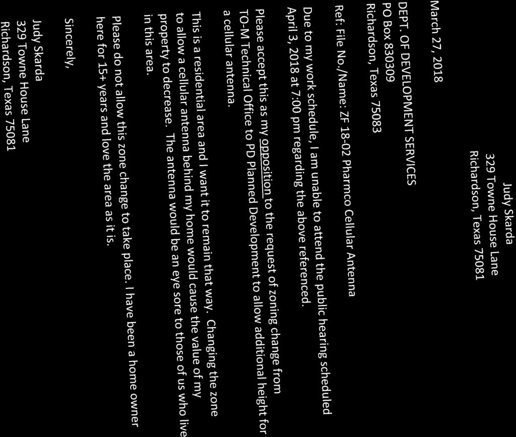
15 Agenda Item 3 Zoning File 18-02: Pharmco Cellular Antenna City of Richardson, Texas City Plan Commission April 3, 2018 Meeting Packet
16 ZONING FILE Attachments: 1. Staff Report 2. Zoning Map 3. Aerial Map 4. Oblique Aerial Photo 5. Zoning Exhibit (Exhibit B ) 6. Detail of Lease Space Area ( Exhibit B-1 ) 7. Tower Elevations (Exhibit C ) 8. Ordinance Applicant s Statement 10. Notice of Public Hearing 11. Notification List 12. Letter in Opposition
17 Staff Report TO: FROM: DATE: RE: City Plan Commission Amy Mathews, Planner AM March 30, 2018 Zoning File 18-02: Pharmco Cellular Antenna REQUEST: A request for approval of zoning change from TO-M Technical Office to PD Planned Development for TO-M Technical Office with modified development standards to allow additional height for a cellular antenna on approximately 0.49 acres located at 302 S. Bowser Road, south of Frances Way, on the west side of S. Bowser Road. (See applicant s statement for further explanation) APPLICANT & PROPERTY OWNER: Peter Kavanagh, Zone Systems, Inc. & Betty Bai, Pharmco International, Inc. EXISTING DEVELOPMENT: The 0.49-acre tract located at 302 S. Bowser Road contains a 6,239 square foot medical research and development building. ADJACENT ROADWAYS: Bowser Road: Four-lane, divided collector, 4,220 vehicles per day on all lanes, northbound and southbound north of Main Street (2016). SURROUNDING LAND USE AND ZONING: North: South: East: West: Public/Institutional/School; R-1500-M Residential Single-family; R-1500-M Residential Multi-family/Group Quarters; A-950-M Apartments Single-family; I-M(1) Industrial D EVELOPMENT S ERVICES
18 FUTURE LAND USE PLAN: Neighborhood Mixed-Use: Neighborhood Mixed-Use areas are characterized by mixed or multiple land uses occurring within a single development and/or a single building. These districts are typically built around small, pedestrian-friendly blocks and common open space. Uses include various types of residential, retail, personal service, and neighborhood-scale offices. The overall intensity of development is generally low to medium depending upon surrounding land uses and the transportation infrastructure serving the area. Future Land Uses of Surrounding Area: North: Neighborhood Mixed-Use South: Neighborhood Residential East: Neighborhood Mixed-Use West: Neighborhood Residential EXISTING ZONING: The property is currently zoned TO-M Technical Office. TRAFFIC/ INFRASTRUCTURE IMPACTS: The requested Special Permit will not have any impact on the surrounding roadway system or the existing utilities in the area. STAFF COMMENTS: Background: In 2008, the site was rezoned from R-1500-M Residential to TO-M Technical Office (Ordinance No. 3709) in order to relocate the Pharmco International headquarters from Plano to Richardson. Pharmco International is a global health products company specializing in health, consumer and medical products. Ordinance No includes specific language that uses on the site within the existing building are limited to research and development functions for health, consumer, medical and veterinary products, including product testing, new product development and existing product modifications, along with administrative office activities, small batch manufacturing/packaging of test market products and warehousing not to exceed 3,500 square feet. No other TO-M activities shall be permitted. The current request is for the addition of a commercial cellular antenna facility at the southern end of the property with no changes proposed to the existing building/business. Request: The applicant s request is to rezone the site from TO-M Technical Office to a PD Planned Development for the TO-M Technical Office with modified development standards to allow a 129 foot tall cellular antenna. The City s Comprehensive Zoning Ordinance allows a freestanding antenna installation as long as it complies with the height and area regulations of the applicable zoning district. Due to the site s proximity to residentially zoned areas (both directly north and east), the height for the proposed cellular antenna is limited to 25 feet. X:\Zoning\Zoning Cases\2018\ZF Richardson Pharmco 302 S Bowser\ CPC Mtg\ZF 1802 Staff Report.docx 2
19 The cellular facility is needed to improve cellular service to the adjacent areas based on new technology, the increased use of cellular devices, and the number of emergency 911 calls handled in the area (see Applicant s Statement for details). The tower includes proposed antennas mounted at a height of approximately 123 feet, with space for up to two future antenna locations (see Tower Elevation). In addition, the tower will have a lightning rod at the top of the pole, measuring approximately four feet. All cables will be interior and the antennas will be mounted to the outside of the pole. Prior to building permits, the pole will undergo all required structural analysis. The lease space is approximately 2,031 square feet and will be completely enclosed with an eight-foot tall masonry screening wall with an iron security gate. The lease space is located on the south end of the 0.48 acre lot. The tower and all associated ground equipment will be contained in the enclosed area. The enclosure includes room for the proposed T-Mobile lease space and additional future leasers. The applicant is requesting that there be no front or rear setbacks for the cellular facility lease space area, including the masonry screening wall and associated equipment within the enclosure due to the configuration of the lot, while Ordinance No requires a 50-foot front yard setback, a 3.5-foot side yard setback and a 1-foot rear yard setback for the existing building. No changes are proposed to the existing 6,239 square foot research building and the current parking is adequate for the existing and proposed uses, an enclosure will be built around the existing dumpster located on site. The wall will match that of the existing building and new enclosure for the cellular facility. Correspondence: As to date, staff has received one letter in opposition (see attached). Motion: The Commission will be making a recommendation to the City Council regarding this request. The Commission may approve the request, add or amend conditions, or recommend denial of the request. Should the Commission accept the applicant s request as presented, the motion should include the following special conditions: That Ordinance No is hereby amended and restated to read as follows: 1. The subject site shall be zoned PD Planned Development District for the TO-M Technical Office District shall be developed in accordance with the Zoning Exhibit and Zoning Exhibit Detail attached hereto as Exhibits B & B-1 and the Tower Elevation attached hereto as Exhibit C ; subject to the following condition: a. Permitted Uses: i. Activities on the property and within the existing building shall be limited to research and development functions for health, consumer, medical and veterinary products, including product testing, new product development and existing product modifications, along with administrative office activities, small batch manufacturing/packaging of test market products and warehousing not to exceed 3,500 square feet. X:\Zoning\Zoning Cases\2018\ZF Richardson Pharmco 302 S Bowser\ CPC Mtg\ZF 1802 Staff Report.docx 3
20 ii. A cellar antenna with a maximum height of one hundred and twenty-nine (129) feet shall be allowed. b. Screening wall: No masonry screening wall shall be required adjacent to residential zoned property to the north or along the railroad right-of-way to the west. c. Setbacks to existing structure: The following setbacks shall be permitted to accommodate the existing structure: i. Front setback: 50' from Bowser Road ii. Side setback: 3'6" along the northern property line iii. Rear setback: l' from the western property line d. Setbacks to cellular antenna enclosure: i. Front setback: 0 from Bowser ii. Rear setback: 0' from the western property line iii. Side setback: 0 e. Building Height: A second floor shall be allowed within the current building so long as the height of the existing building is not increased and all Building Code requirements are met. Council Hearing Date: The earliest possible City Council hearing date is April 23, X:\Zoning\Zoning Cases\2018\ZF Richardson Pharmco 302 S Bowser\ CPC Mtg\ZF 1802 Staff Report.docx 4
21 Highland Pl Towne House Ln Kansas City Southern RR ZF A R-1100-M Crystal Ct 123-A A-950-M 607-A LR-M(2) Frances Way 785-A R-1500-M 785-A 3709 TO-M SUBJECT PROPERTY 783-A A-950-M 651-A D-1400-M Candlewood Pl 651-A RA-1100-M 811-A R-1500-M Serenade Ln 158-A R-1500-M S Bowser Rd 4 This product is for informational purposes and may not have ZF Zoning Map been prepared for or be suitable for legal, engineering, or surveying purposes. It does not represent an on-the-ground survey and represents only the approximate relative location of property boundaries.
22 Highland Pl Towne House Ln Kansas City Southern RR ZF Crystal Ct Frances Way SUBJECT PROPERTY Candlewood Pl S Bowser Rd Serenade Ln 4 This product is for informational purposes and may not have ZF Aerial Map been prepared for or be suitable for legal, engineering, or surveying purposes. It does not represent an on-the-ground survey and represents only the approximate relative location of property boundaries.

23


24
25
26

27 ORDINANCE NO AN ORDINANCE OF THE CITY OF RICHARDSON, TEXAS, AMENDING THE COMPREHENSIVE ZONING ORDINANCE AND ZONING MAP OF THE CITY OF RICHARDSON, AS HERETOFORE AMENDED, SO AS TO GRANT A CHANGE IN ZONING FROM R-1500-M RESIDENTIAL WITH A SPECIAL PERMIT FOR A GYMNASTICS CENTER TO TO-M TECHNICAL OFFICE SUBJECT TO SPECIAL CONDITIONS FOR THE PROPERTY LOCATED AT 302 SOUTH BOWSER ROAD, RICHARDSON, TEXAS AND BEING DESCRIBED IN EXHIBIT "A"; PROVIDING A REPEALING CLAUSE; PROVIDING A SEVERABILITY CLAUSE; PROVIDING A SAVINGS CLAUSE; PROVIDING FOR A PENALTY OF FINE NOT TO EXCEED THE SUM OF TWO-THOUSAND ($2,000.00) DOLLARS FOR EACH OFFENSE; AND PROVIDING AN EFFECTIVE DATE. (ZONING FILE 0808). WHEREAS, the City Plan Commission of the City of Richardson and the governing body of the City of Richardson, in compliance with the laws of the State of Texas and the ordinances of the City of Richardson, have given requisite notice by publication and otherwise, and after holding due hearings and affording a full and fair hearing to all property owners generally and to all persons interested and situated in the affected area and in the vicinity thereof, the governing body, in the exercise of its legislative discretion, has concluded that the Comprehensive Zoning Ordinance and Zoning Map should be amended; NOW THEREFORE, BE IT ORDAINED BY THE CITY COUNCIL OF THE CITY OF RICHARDSON, TEXAS: SECTION 1. That the Comprehensive Zoning Ordinance and Zoning Map of the City of Richardson, Texas, duly passed by the governing body of the City of Richardson on the 5 th day of June, 1956, as heretofore amended, be, and the same is hereby amended so as to grant a change in zoning from R-1500-M Residential with a special permit for a gymnastics center to TO-M Technical Office subject to special conditions for the property located at 302 South Bowser Road Richardson, Dallas County, Texas, and being more particularly described in Exhibit "A" and made a part hereof for all purposes. SECTION 2. That the change in zoning to TO-M Technical Office is hereby granted subject to the following special conditions: 1. Screening wall: No masonry screening wall shall be required adjacent to residential zoned property to the north or along the railroad right-of-way to the west. 2. Setbacks to existing structure: The following setbacks shall be permitted to accommodate the existing structure: 27572
28 Front setback: 50' from Bowser Road Side setback: 3'6" along the northern property line Rear setback: l' from the western property line 3. Building Height: A second floor shall be allowed within the current one-story building so long as the height of the existing building is not increased and all Building Code requirements are met. 4. Permitted Uses: Activities on the property and within the building shall be limited to research and development functions for health, consumer, medical and veterinary products, including product testing, new product development and existing product modifications, along with administrative office activities, small batch manufacturing/packaging of test market products and warehousing not to exceed 3,500 square feet. No other TO-M activities shall be permitted. 5. Floor Plan: Manufacturing activities shall be limited to the area indicated on the floor plan, attached as Exhibit "B", and which is hereby approved. 6. Concept Plan: Development shall take place generally in compliance with the Concept Plan, attached as Exhibit "C", and which is hereby approved. The existing loading dock may be relocated to the northern portion of the building provided all City of Richardson requirements are satisfied. 7. The property shall be developed and used only in accordance with the Floor Plan, Exhibit "B" and the Concept Plan, Exhibit "C". SECTION 3. That the property shall be used only in the manner and for the purpose provided for by the Comprehensive Zoning Ordinance of the City of Richardson, as heretofore amended, and as amended herein. SECTION 4. That Ordinance No is hereby repealed, and all provisions of the ordinances of the City of Richardson in conflict with the provisions of this ordinance be, and the same are hereby, repealed, and all other provisions of the ordinances of the City of Richardson not in conflict with the provisions of this ordinance shall remain in full force and effect. SECTION 5. That an offense committed before the effective date of this ordinance is governed by prior law and the provisions of the City of Richardson Comprehensive Zoning Ordinance, as amended, in effect when the offense was committed and the former law is continued in effect for this purpose
29 SECTION 6. That should any sentence, paragraph, subdivision, clause, phrase or section of this Ordinance be adjudged or held to be unconstitutional, illegal or invalid, the same shall not affect the validity of this Ordinance as a whole, or any part or provision thereof other than the part so decided to be invalid, illegal or unconstitutional, and shall not affect the validity of the Comprehensive Zoning Ordinance as a whole. SECTION 7. That any person, firm or corporation violating any of the provisions or terms of this Ordinance shall be subject to the same penalty as provided for in the Comprehensive Zoning Ordinance of the City of Richardson, as heretofore amended, and upon conviction shall be punished by a fine not to exceed the sum of Two Thousand ($2,000.00) Dollars for each offense; and each and every day such violation shall continue shall be deemed to constitute a separate offense. SECTION 8. That this Ordinance shall take effect immediately from and after its passage and publication of the caption, as the law and charter in such case provide. DULY PASSED by the City Council of the City of Richardson, Texas, on the 12th day of May A(/f~T1JR~ CITY ATTORNEY (PGs:tc 05/6/08) ~YENROLLED'. -~ CITY SECRETARY 27572
30 Exhibit "A" Legal Description ZF South Bowser Road BEING a Survey of acre tract of land in the W. W. Reed Survey Abstract No. 1250, Dallas County, Texas, and also being in the City of Richardson, Texas, and being part of Lot 1, Block 1, of the STONEWAY PRIVATE SCHOOL ADDITION, an addition to the City of Richardson, Texas as recorded in Volume 78062, Page 1397 of the Map records of Dallas County, Texas and said acre tract of land being more particularly described as follows: BEGINNING AT A POINT in the east RO.W. line of the G.c. & S.P. RR that is S 05 58'00"E, ft. from the south line of Frances Way; THENCE N '21 "E and crossing the south line of Lot 1 of the aforementioned Stoneway Private School Addition, ft. to a point in the West Line of South Bowser Road, said point being in a curve to the right that has a central angle of 11 12'23" and a radius of ft., and said point having a radial bearing of N 62 48'23"W; THENCE around said curve ft. to the beginning of a curve to the left that has a central angle of 43 49'00" and a radius of ft.; THENCE around said curve, ft., to the intersection of said west line of South Bowser Road with the aforementioned east line of the G.c. & S.P. R.R.; THENCE N 05 58'00" W along said line, ft. to the POINT OF BEGINNING and containing acres of land
31 27572 Exhibit "B" Floor Plan
32 ;zc,~.>. -(Jj)~ r--~': - i -, <, " \.:.9 I,r.r O' t- ',4'i ~ ')('...,J, 0... ~... l~4 ~ / 'V-. <, '<, 9. / -'" C'\ FLOOR PLAN... I ' / "<, ~...:.. """,'f:. " / \41 "... ~..". "lit...', /... ""-... T-t-...--~ I / "'-.'~'"'' '\,/....'t~. -. -', <, r. / ~ <, i-f:"..."...-. :~ " 2.: ~ -, 1'10\ cv '..,"11 ;: ~ "<"!!,~,.,!."'?::."'-.,.-(~, ''''-." 0" I'."',", ~.'~ «<.,. T.~~~.~,~.~",',."T,,)~',,/,)c' ~,~ ;r.~~~~.~:'" 1st FI~r~.~n~ae:tur,irig " '~"""'!'!~~!'IC~-'.._ , ','.<... ~ '~ ':,,'I ~ -,(t' 2n'd Floor -.Office,Sp8i;e imezzaniri'e Litv.. '2,.usSJ.'. -+ ' ~- ".j -"'ii,,::~ ~d_, ~ ~'o'... tw.o S. Bowser Rd.? 1. Exhibit B Part of Ordinance j 4't
33 27572 Exhibit "C' Concept Plan

34 J.. a...~ 0" r- t'i" : t >?: ~.;,,'... ~! ". ":I ~~ -,; 'r ~~,,1,..~ ~., ~ ~j 4" i!
35 ZONING FILE NOTICE OF PUBLIC HEARING CITY OF RICHARDSON, TEXAS PUBLIC HEARING DATE & TIME: Monday, April 28, 2008, 7:30 p.m. PLACE: Richardson Civic Center/City Hall, 411 W. Arapaho Rd., City Council Chamber. PURPOSE OF THE HEARING: The City Council will consider a request by Tze-Rou Kuo for I-M(1) Industrial zoning at 302 S. Bowser Road. The property is currently zoned R-1500-M ~Residential. ~ ~OWNER: Robert Melear ~APPLICANT: Tze-Rou Kuo "" o E-< ~ P-< E-< o Z ~ z o (J) ~ (J) o P-< p:; t> P-< Z o H E-< ~ o "" Z H All interested property owners are encouraged to attend this hearing. Persons wishing their opinion to be part of the record who are unable to attend may send a written reply prior to the date of the hearing to Pamela Schmidt, City Secretary, P. O. Box , Richardson, Texas, I hereby certify that this notice was posted on the Civic Center/City Hall Bulletin Board no later than 5:30 p.m., Friday, Apri/18, t;;;ch~ Pamela Schmidt, City Secretary This building is wheelchair accessible. Any requests for sign interpretive services must be made 48 hours ahead of meeting. To make arrangements, call via TOO or call to reach
36
37 Amy Mathews Senior Planner City of Richardson 411 West Arapaho, Richardson, TX March 15, 2018 Subject: City of Richardson TELECOMMUNICATIONS TOWERS AND ANTENNAS Site Address: 302 S. Bowser Rd. Richardson, Texas CTG Site Number: CTG-TX T-Mobile site: Richardson DA03567C To Whom It May Concern: T-Mobile South LLC ( T-Mobile ) respectfully submits this letter in an effort to site a new telecommunications tower at 302 S. Bowser Rd. Richardson, Texas The proposed new monopole tower is required to provide adequate RF signal strength for the T-Mobile network within the City of Richardson near the intersection of Frances Way and S. Bowser Road. T-Mobile Engineering has determined that the proposed site is needed in order to provide inbuilding signal strength to the residential and school buildings surrounding the S. Bowser Road area. Previous optimization efforts in the area were not able to improve the area coverage and T- Mobile developed a search area for a new site to maintain our network coverage. The search area included a 1/4 mile radius from the target area. This radius extended from the intersection of Frances Way and S. Bowser Road. T-Mobile looks for co-location opportunities and has made every effort to utilize existing infrastructure to support its network. Given the geographic area in which the T-Mobile Engineering Team determined that the base station needs to be located, there were no opportunities to co-locate on existing structures. The following are the results of a thorough evaluation of this area: a) No existing towers or suitable structures of any sort were observed within the 1/4 mile radius from the proposed site that meet T-Mobile s requirement to cover the target objectives.
 Co-location was not an option, as there were no existing towers or other structures within the 1/4 mile radius from the proposed site required to meet T-Mobile s engineering needs.")
38 b) No towers or other structures existed within the 1/4 mile radius from the proposed site that could be reasonably altered for substantial additional height to meet T-Mobile s engineering requirement. c) Co-location was not an option, as there were no existing towers or other structures within the 1/4 mile radius from the proposed site required to meet T-Mobile s engineering needs. Additionally, this new site will maintain access to T-Mobile s enhanced E911 services as required by the FCC and local PSAP and maintain safety to the citizens of the City of Richardson, Texas. T-Mobile owns and operates the following frequency bands in Dallas County: Blocks: A, B Blocks: A1, A2, C3, C4, C5, D, E, F1, F2 700MHz & 600Mhz Bands 1900MHz & 2100Mhz Bands If you have any further technical questions related to this application, you may contact me at Sincerely, Mohammed Zaki cc: Site File, enclosure: Current coverage propagation map Proposed coverage propagation map
")
39 DA03567 Surrounding area (Google Earth)
")
40 DA03567 Surrounding area (Google Earth)
41 E911 Data Graph represents the number of E911 calls being handled per site in the area of concern. DA01205B & DA01213B handles the most number of Emergency calls. One of the objectives for building DA03567 is to enhance e911 coverage in the north east area of Richardson Days - e911 Call Traffice DA01205B DA07063M DA01339C DA01213B DA07064M DA01221B T-Mobile Confidential
 4")
42 DA03567 ACTUAL ZONE COVERAGE (RSRP) 4 CURRENT RSRP
 5 NEW")
43 DA03567B NEW 125 (RSRP) 5 NEW RSRP

44 Notice of Public Hearing City Plan Commission Richardson, Texas An application has been received by the City of Richardson for a: PLANNED DEVELOPMENT (RESCHEDULED FROM MARCH 20, 2018) File No./Name: ZF / Pharmco Cellular Antenna Property Owner: Betty Bai, Pharmco International, Inc. Applicant: Peter Kavanagh, Zone Systems Inc. Location: 302 S. Bowser Road, south of Frances Way, on the west side of S. Bowser Road. (See map on reverse side) Current Zoning: TO-M Technical Office Request: A request for approval of zoning change from TO-M Technical Office to PD Planned Development for TO-M Technical Office with modified development standards to allow additional height for a cellular antenna. The City Plan Commission will consider this request at a public hearing on: TUESDAY, APRIL 3, :00 p.m. City Council Chambers Richardson City Hall, 411 W. Arapaho Road Richardson, Texas This notice has been sent to all owners of real property within 200 feet of the request; as such ownership appears on the last approved city tax roll. Process for Public Input: A maximum of 15 minutes will be allocated to the applicant and to those in favor of the request for purposes of addressing the City Plan Commission. A maximum of 15 minutes will also be allocated to those in opposition to the request. Time required to respond to questions by the City Plan Commission is excluded from each 15 minute period. Persons who are unable to attend, but would like their views to be made a part of the public record, may send signed, written comments, referencing the file number above, prior to the date of the hearing to: Dept. of Development Services, PO Box , Richardson, TX The City Plan Commission may recommend approval of the request as presented, recommend approval with additional conditions or recommend denial. Final approval of this application requires action by the City Council. Agenda: The City Plan Commission agenda for this meeting will be posted on the City of Richardson website the Saturday before the public hearing. For a copy of the agenda, please go to: For additional information, please contact the Dept. of Development Services at and reference Zoning File number ZF Date Posted and Mailed: 03/23/2018 Development Services Department City of Richardson, Texas 411 W. Arapaho Road, Room 204, Richardson, Texas
45 Highland Pl Towne House Ln Kansas City Southern RR ZF Crystal Ct Frances Way 200' NOTIFICATION BOUNDARY SUBJECT PROPERTY Candlewood Pl S Bowser Rd Serenade Ln 4 This product is for informational purposes and may not have ZF Notification Map been prepared for or be suitable for legal, engineering, or surveying purposes. It does not represent an on-the-ground survey and represents only the approximate relative location of property boundaries.
46 GINSBERG JACOB TRUSTEE 4502 W LOVERS LN DALLAS, TX ZAVERI IMTIAZ A PO BOX RICHARDSON, TX GHEBREMEDHIN ABISELOM 313 TOWNE HOUSE LN RICHARDSON, TX ABREHA MEWAEL EYASU 1320 NORMANDY LN ALLEN, TX TESFAMARIAM TIBLETZ WOLDAY 319 TOWNE HOUSE LN RICHARDSON, TX TESFAMARIAM TIBLETZ WOLDAY 315 TOWNE HOUSE LN RICHARDSON, TX MARONEY JAMES BRADLEY 321 TOWNE HOUSE LN RICHARDSON, TX SAURATHIA ARIF D & SHADAAN A 317 TOWNE HOUSE LN RICHARDSON, TX HAILEMICEAL HELEN TESFALDET 323 TOWNE HOUSE LN RICHARDSON, TX TESFAMARIAM TIBLETZ WOLDAY 3532 HUTCH DR PLANO, TX TESFAMARIAM TIBLETZ WOLDAY 327 TOWNE HOUSE LN RICHARDSON, TX GINSBERG JACOB TRUSTEE 4502 W LOVERS LN DALLAS, TX SKARDA JUDITH A 329 TOWNE HOUSE LN RICHARDSON, TX SKARDA JUDITH A 329 TOWNE HOUSE LN RICHARDSON, TX QURESHI MAJID A 331 TOWNE HOUSE LN RICHARDSON, TX MUHAMMED SAMAD 333 TOWNE HOUSE LN RICHARDSON, TX TOLER WALTER D & DEBORAH ANN H TOLER 1327 RUSK DR RICHARDSON, TX BAILEY BARBARA S 341 TOWNE HOUSE LN RICHARDSON, TX ROBERTS MERYL LOUISE 335 TOWNE HOUSE LN RICHARDSON, TX GEBREGZIABHER KALAYOU & ASRES ALEM PLANO RD APT 5301 DALLAS, TX FRANCES WAY MBP LLC 2460 W 26TH AVE STE 355C DENVER, CO TOLER WALTER D & DEBORAH ANN H TOLER 1327 RUSK DR RICHARDSON, TX NOJOUMIAN CARON YIN 803 SERENADE LN RICHARDSON, TX GINSBERG MAJOR 4502 W LOVERS LN DALLAS, TX GINSBERG MAJOR 4502 W LOVERS LN DALLAS, TX GRACE TOWNHOUSE PROPERTIES 8750 TOWER ESTATES CIR ANCHORAGE, AK GRACE TOWNHOUSE PROPERTIES 8750 TOWER ESTATES CIR ANCHORAGE, AK GRACE TOWNHOUSE PROPERTIES 8750 TOWER ESTATES CIR ANCHORAGE, AK STEPP JOHNNIE R 7810 SE 30TH ST APT 307 MERCER ISLAND, WA SMITH JOANNE 527 N AZUSA AVE # 158 COVINA, CA
47 AARUSHI REAL ESTATE INVESTMENT 9400 OLD VERANDA RD PLANO, TX, KANSAS CITY SOUTHERN RR PO BOX KANSAS CITY, MO, PHARMCO INTERNATIONAL INC 302 S BOWSER RD RICHARDSON, TX,
48
49 Agenda Item 4 Zoning File 18-03: Edgecore Data Center City of Richardson, Texas City Plan Commission April 3, 2018 Meeting Packet
50 ZONING FILE Attachments: 1. Staff Report 2. Zoning Map 3. Aerial Map 4. Zoning Exhibit (Exhibit B ) 5. Elevations (Exhibits C-1 to C-3 ) 6. Security Fence Detail (Exhibit D ) 7. PD Conditions (Exhibit E ) 8. Color Renderings 9. Applicant s Statement 10. Notice of Public Hearing 11. Notification List
51 Staff Report TO: FROM: DATE: RE: City Plan Commission Amy Mathews, Planner AM March 30, 2018 Zoning File 18-03: Edgecore Data Center REQUEST: A request for approval of zoning change from I-M(1) Industrial to PD Planned Development for I-M(1) Industrial with modified development standards on approximately acres located at the northeast corner of Shiloh Road and Research Drive. (See applicant s statement for further explanation) APPLICANT & PROPERTY OWNER: Chet Leugers, Pacheco Koch and Jay DiMaggio, Mount Elbert Capital Partners EXISTING DEVELOPMENT: The subject tract is undeveloped. ADJACENT ROADWAYS: Breckenridge Boulevard: Four-lane, divided arterial; 3,880 vehicles on all lanes, eastbound and westbound, east of Shiloh Road (2016). Shiloh Road: Six-lane, divided arterial; 9,460 vehicles on all lanes, northbound and southbound, south of Research Drive (2016). Telecom Parkway: Four-lane, divided arterial; 3,340 vehicles on all lanes, northbound and southbound, between Research Drive and Breckenridge Boulevard (2016). SURROUNDING LAND USE AND ZONING: North: South: East: West: Vacant / PD Planned Development Office /I-M(1) Industrial Industrial / I-M(1) Industrial Commercial / I-M(1) Industrial and LR-M(1) Local Retail D EVELOPMENT S ERVICES
52 FUTURE LAND USE PLAN: Office/Industry: The Office/Industry category designates areas of low- and medium-density office, as well as manufacturing and distribution facilities. Redevelopment is anticipated in lowperforming areas to in response to changes in building format and market demand. Higher intensity office uses may be appropriate at certain locations. Manufacturing and distribution facilities within this classification should be carefully located and designed to minimize their impact on nearby residential uses. Future Land Uses of Surrounding Area: North: Office/Industry South: Office/Industry East: Office/Industry West: Community Commercial EXISTING ZONING: The property is currently zoned I-M(1) Industrial. TRAFFIC IMPACTS: The requested zoning change will not have any impact on the surrounding roadway system or the existing utilities in the area. The existing zoning allows manufacturing and office uses, both of which would produce much more traffic, based on the number of parking spaces and typical traffic counts for the uses. STAFF COMMENTS: The subject property was rezoned in 1971 (Ordinance No. 712-A) to allow for development under the I-M(1) Industrial district with special conditions to allow an airport and all O-M Office uses. However, an airport was never developed on the site. The subject property is approximately undeveloped acres of a 99 acre lot. The remaining roughly 66 acre site contains the Fujitsu campus which was approved in At that time, questions were raised regarding how the western 33 acre subject property would develop; however, there were no plans for the property at the time and the site has remained undeveloped since that time. The applicant is requesting a zoning change to a PD Planned Development under the I-M(1) Industrial district with modification to the district development standards. The proposed change in zoning includes amendments to the current I-M(1) zoning district for development of a 900,000 square foot data center campus (Tract 1) and an electrical substation (Tract 2). The two tracts will be owned and developed separately. Proposed modifications to the I-M(1) Industrial District Regulations are summarized below with additional details and explanations following. Proposed modifications/additional regulations for Tract 1 include the following: Use Regulations: allow a Data Center (defined below) as an additional use in the I-M(1) District. X:\Zoning\Zoning Cases\2018\ZF Edgecore Data Center Campus NE Sec of Shiloh Rd & Research Dr\ CPC Meeting\ZF CPC Staff Report.docx 2
53 Height Regulations: o Allow the second story to be 22-feet tall. The I-M(1) district currently restricts additional stories over the first story to 15 in height. o All heights will be measured as the vertical distance of a building or portion thereof measured from the mean level of the ground surrounding the building. The maximum building height shall be 44 feet, measured to the highest point of the roof s surface if a flat surface, and excluding the parapet, rooftop equipment, and rooftop screening. The maximum building parapet height shall be 50 feet. The maximum height of roof equipment and associated screening shall be 75-feet. Screening and fencing: o A metal security fence with a max height of 8-feet (see Exhibit D) o Louvered screen walls will be used to screen the rooftop chillers and to screen ground level equipment Parking: Parking ratio for the data center use is 1:3,000 square feet o Parking may be built in phases per the discretion of the Director of Development Services Approvals: o Development plans may be approved by City Staff if in substantial conformance with the exhibits attached hereto (applies to Tract 1 only). o The City Manager or designee shall have the authority to approve a request for minor modifications to development plans approved within or required by this planned development district. For purposes of this planned development, a minor modification shall be defined as (i) a change to a footprint of a building in which the proposed footprint complies with all development standards set forth herein, and (ii) except as otherwise provided in (i), a change which does not increase the building coverage, floor area ratio, does not decrease any of the specified area regulations or enumerated parking ratios, nor substantially changes the access or circulation on or adjacent to the site (applies to Tracts 1 and 2). Proposed modifications/additional regulations for Tract 2 include the following: Use Regulations: allow an Electrical Substation (defined below) as an additional use in the I-M(1) District. Screening and Fencing: o Concrete or concrete block screening wall min 10-feet 4-inches o A minimum of one canopy tree per every 20 linear feet of screening wall o A minimum of one ornamental tree per every 12 linear feet of screening wall o A least one gallon of ground cover planted for every 12 linear feet of screening wall X:\Zoning\Zoning Cases\2018\ZF Edgecore Data Center Campus NE Sec of Shiloh Rd & Research Dr\ CPC Meeting\ZF CPC Staff Report.docx 3
54 Data Center and Electrical Substation uses are not defined in the Comprehensive Zoning Ordinance (CZO); therefore the following definitions are proposed for the added uses: a. Data Center (Tract 1) means a building or facility primarily dedicated to housing computer systems and associated components generally including redundant or backup power supplies, redundant data communication connections, environmental controls, and security devices and also including office areas for support staff. It is permitted to include outdoor equipment necessary for the data center, including, but not limited to, generators, fuel tanks, and UPS modules. b. Electrical Substation (Tract 2) means a general use electrical substation owned and operated by a provider of electrical service that will provide power to the subject property and other properties. Switchyard means an enclosed area of a power system containing the switchgear. Tract 1 is approximately acres in size and planned for development as a data center. The CZO limits building height for lots not located within 300 feet of a residential district to 75 feet at the setback line, not to exceed 25 feet for the first story and 15 feet for each additional story with two additional feet of building height allowed for each one foot of setback provided. The five buildings proposed on Tract 1 have varying setbacks, allowing for multiple height limits. The applicant is proposing to limit the maximum building heights to be measured as the vertical distance of a building or portion thereof measured from the mean level of the ground surrounding the building as follows: building height: 44-feet, parapet height 50-feet, and roof equipment and associated screening height 75-feet. The CZO also limits any floor above the first floor to 15 feet. All five of the proposed buildings are proposed to be two stories and the applicant is requesting to increase the allowed second floor height limit to 22 feet in height. Building 1 & 2 are mirrored replications of buildings 3 & 4, each with roughly 4,000 square feet of office and 358,000 square feet of data center warehouse. Both of these sets of buildings are connected with a common building which includes the main entrances into the structures. Building 5 has 2,000 square foot of office and 124,400 square feet of data center warehouse. All these buildings have external stairs for egress. The exterior façade of the buildings on Tract 1 will consist of a combination of concrete tilt wall, glass, louvered screen walls, and metal architectural panels (see Elevations). Louvered screen walls will be used to screen the rooftop chillers. The ground level equipment will be screen with a 21 foot tall architectural metal louver screening wall, similar to those to be used on the roof. Development of the data center buildings may occur in phases as each new building is needed to provide additional storage capacity and the buildings may be constructed in any order. The proposed parking ratio is, one parking space for every 3,000 square feet of floor area of the data center use, with the office parking ratio being 1 space per 300 square feet, while existing data centers have been parked at various parking ratios that closely resemble one space for every 1,000 square feet of data center use and 1 space per square feet of office space. X:\Zoning\Zoning Cases\2018\ZF Edgecore Data Center Campus NE Sec of Shiloh Rd & Research Dr\ CPC Meeting\ZF CPC Staff Report.docx 4
55 Parking will be built in phases, to coincide with each building in Tract 1. If it is determined by the Director of Development Services that insufficient parking has been provided, the property owner will be required to bring the property into compliance within 90 days of written notice to the property owner. A determination of insufficient parking will be ascertained if vehicles are parked on non-paved surfaces within the property or the provided parking is fully occupied on a regular basis during typical weekday working hours. In addition, Tract 1 will have two gated entrances with a guard house; one specifically for truck traffic and the other for guests, which includes a turnaround. There is another electronic, non-manned entrance on Breckinridge Boulevard. Tract 2 consists of approximately 2.90-acres at the southwest corner of the overall site as shown on the Zoning Exhibit. This area is planned for development of an electrical substation and switchyard. The site will be screened by a concrete or architectural block wall that will be a minimum of 10 feet 4 inches in height, supplemented with landscape screening to consist of canopy trees planted at a minimum of one per 20 linear feet and ornamental trees planted at a minimum of one per 12 linear feet. In addition, the site will be enclosed with a security fence to have a minimum height of 8 feet. Tract 2 has two secured entrances, one from Research Drive and the other interior to Tract 1. This site will be replatted as a separate lot from Tract 1 prior to development. The entire site (Tracts 1 & 2) will be enclosed with an 8-foot tall heavy steel security fence. There is also an existing 10 foot wide public trail which will be relocated and constructed around the entire perimeter with the first building. The existing utilities located at the northwest corner of the property; at the intersection of Shiloh Road and Breckinridge Boulevard, will remain and will be enclosed by the previously mention security fence. Correspondence: As of this date, no correspondence has been received. Motion: The Commission will be making a recommendation to the City Council regarding this request. The Commission may approve the request, add or amend conditions, or recommend denial of the request. Should the CPC accept the applicant s request as presented, the motion should include the following special conditions: 1. The subject site shall be zoned PD Planned Development District for the I-M(1) Industrial District and shall be developed in accordance with the Zoning Exhibit attached hereto as Exhibit B, the Concept Elevations attached hereto as Exhibits C-1 to C-3, the Security Fence Detail attached hereto as Exhibits D, and the Development Regulations attached hereto and Exhibit E. Council Hearing Date: City Council hearing date is April 9, X:\Zoning\Zoning Cases\2018\ZF Edgecore Data Center Campus NE Sec of Shiloh Rd & Research Dr\ CPC Meeting\ZF CPC Staff Report.docx 5
56 Shiloh Rd Shiloh Rd ZF A I-M(1) 4173 PD 2038-A I-FP(1) Breckinridge Blvd 1003-A I-M(1) SUBJECT PROPERTY 3742 LR-M(1) 712-A I-M(1) 3618 LR-M(1) Research Dr Pres George Bush Hwy 2648-A A-950-M Shiloh Rd Telecom Pkwy 2498-A A-950-M 4 This product is for informational purposes and may not have ZF Zoning Map been prepared for or be suitable for legal, engineering, or surveying purposes. It does not represent an on-the-ground survey and represents only the approximate relative location of property boundaries.
57 Shiloh Rd Shiloh Rd ZF Breckinridge Blvd SUBJECT PROPERTY Research Dr Pres George Bush Hwy Shiloh Rd Telecom Pkwy 4 This product is for informational purposes and may not have ZF Aerial Map been prepared for or be suitable for legal, engineering, or surveying purposes. It does not represent an on-the-ground survey and represents only the approximate relative location of property boundaries.

58 Overall Gross Area: 1,453,167 SF Acres BRECKINRIDGE BOULEVARD 2 LOCATOR MAP scale: NOT TO SCALE SHILOH ROAD Substation Tract 2, Proposed Substation: 126,896 SF 2.9 Acres RESEARCH (60' R.O.W.) DRIVE PROJECT STAR 1 PROPOSED SITE PLAN scale: 1"=80' ZONING EXHIBIT B
59 21' TOP OF S LEVEL '-0" 115'-0" 417'-0" 74' - 8" TOP OF SCREENWALL 57' - 6" TOP OF ALUMINUM WALL 50' - 0" TOP OF WALL 44' - 0" ROOF 21' - 0" LEVEL 2 AND SCREENWALL 1 BUILDING SOUTH ELEVATION - VIEW FROM RESEARCH DRIVE scale: 1"=30' 0' - 0" LEVEL '-0" 115'-0" 417'-0" 40'-0" 40'-0" 74' - 8" TOP OF SCREENWALL 57' - 6" TOP OF ALUMINUM WALL 50' - 0" TOP OF WALL 44' - 0" ROOF 21' - 0" LEVEL 2 AND SCREENWALL 2 BUILDING NORTH ELEVATION - VIEW FROM SERVICE LANE scale: 1"=30' 0' - 0" D C B A 74' - 8" TOP OF SCREENWALL 57' - 6" TOP OF ALUMINUM WALL 50' - 0" TOP OF WALL 44' - 0" ROOF 21' - 0" LEVEL 2 AND SCREENWALL 3 BUILDING EAST ELEVATION - VIEW FROM THE EAST SIDE OF PROPERTY scale: 1"=30' 0' - 0" LEVEL 1 A B C D 74' - 8" TOP OF SCREENWALL 50' - 0" TOP OF ALUMINUM WALL 50' - 0" TOP OF WALL 44' - 0" ROOF 21' - 0" LEVEL 2 AND SCREENWALL 0' - 0" LEVEL 1 PROJECT STAR 4 BUILDING WEST ELEVATION - VIEW FROM SHILOH ROAD scale: 1"=30' EXTERIOR ELEVATIONS EXHIBIT C1
60 21' TOP OF S LEVEL '-0" 115'-0" 417'-0" 74' - 8" TOP OF SCREENWALL 57' - 6" TOP OF ALUMINUM WALL 50' - 0" TOP OF WALL 44' - 0" ROOF 21' - 0" LEVEL 2 AND SCREENWALL 1 BUILDING NORTH ELEVATION - VIEW FROM BRECKINRIDGE BLVD scale: 1"=30' 0' - 0" LEVEL '-0" 115'-0" 417'-0" 40'-0" 40'-0" 74' - 8" TOP OF SCREENWALL 57' - 6" TOP OF ALUMINUM WALL 50' - 0" TOP OF WALL 44' - 0" ROOF 21' - 0" LEVEL 2 AND SCREENWALL 2 BUILDING SOUTH ELEVATION - VIEW FROM SERVICE LANE scale: 1"=30' 0' - 0" D C B A 74' - 8" TOP OF SCREENWALL 57' - 6" TOP OF ALUMINUM WALL 50' - 0" TOP OF WALL 44' - 0" ROOF 21' - 0" LEVEL 2 AND SCREENWALL 3 BUILDING WEST ELEVATION - VIEW FROM SHILOH ROAD scale: 1"=30' 0' - 0" LEVEL 1 A B C D 74' - 8" TOP OF SCREENWALL 50' - 0" TOP OF ALUMINUM WALL 50' - 0" TOP OF WALL 44' - 0" ROOF 21' - 0" LEVEL 2 AND SCREENWALL 0' - 0" LEVEL 1 PROJECT STAR 4 BUILDING EAST ELEVATION - VIEW FROM THE EAST SIDE OF PROPERTY scale: 1"=30' EXTERIOR ELEVATIONS EXHIBIT C2
61 D F E C B A 74' - 8" TOP OF SCREENWALL 57' - 6" TOP OF ALUMINUM WALL 50' - 0" TOP OF WALL 44' - 0" ROOF 55'-0" 21' - 0" LEVEL 2 AND SCREENWALL 0' - 0" LEVEL 1 10'-4" 1 BUILDING 5 - WEST ELEVATION - VIEW FROM SHILO ROAD scale: 1"=30' 74' - 8" TOP OF SCREENWALL 57' - 6" TOP OF ALUMINUM WALL 50' - 0" TOP OF WALL 44' - 0" ROOF 74' - 8" TOP OF SCREENWALL 57' - 6" TOP OF ALUMINUM WALL 50' - 0" TOP OF WALL 44' - 0" ROOF 21' - 0" LEVEL 2 AND SCREENWALL 21' - 0" LEVEL 2 AND SCREENWALL 0' - 0" 0' - 0" LEVEL 1 LEVEL 1 2 BUILDING 5 - NORTH ELEVATION - VIEW FROM BECKENRIDGE BLVD. scale: 1"=30' scale: 1"=30' 3 BUILDING 5 - SOUTH ELEVATION - VIEW FROM STREET INSIDE PORPERTY A B C D E F 21' - 0" TOP OF SCREENWALL 74' - 8" TOP OF SCREENWALL 57' - 6" TOP OF ALUMINUM WALL 50' - 0" TOP OF WALL 44' - 0" ROOF 21' - 0" LEVEL 2 AND SCREENWALL 4 BUILDING 5 - EAST ELEVATION - VIEW FROM STREET INSIDE PROPERTY scale: 1"=30' 0' - 0" LEVEL 1 21' 0' - 0" LEVEL 1 PROJECT STAR 5 EQUIPMENT SCREEN WALL DETAIL scale: 1/4"=1' EXTERIOR ELEVATIONS EXHIBIT C3
62 EXHIBIT E PD DEVELOPMENT STANDARDS 1. Base Zoning District. The subject site shall be zoned PD Planned Development District for the I-M(1) Industrial District and shall be developed in accordance with the Zoning Exhibit attached hereto as Exhibit B, the Concept Elevations attached hereto as Exhibits C-1 to C-3, the Security Fence Detail attached hereto as Exhibits D, and which are hereby approved 2. Permitted Uses. All the uses allowed in the I-M(1) Industrial District and a data center use permitted on Tract 1 and an electrical substation on Tract Definitions. a. Data Center means a building or facility primarily dedicated to housing computer systems and associated components generally including redundant or backup power supplies, redundant data communication connections, environmental controls, and security devices and also including office areas for support staff. It is permitted to include outdoor equipment necessary for the data center, including, but not limited to, generators, fuel tanks, and UPS modules. b. Electrical Substation means a general use electrical substation owned and operated by a provider of electrical service that will provide power to the subject property and other properties. Switchyard means an enclosed area of a power system containing the switchgear. c. Tract 1 means the approximately acre property shown on the Zoning Exhibit that is planned for development as a data center. d. Tract 2 means the approximately 2.90-acre property shown on the Zoning Exhibit that is planned for development as a substation. 4. Minor Modifications: The City Manager or designee shall have the authority to approve a request for minor modifications to development plans approved within or required by this planned development district. For purposes of this planned development, a minor modification shall be defined as (i) a change to a footprint of a building in which the proposed footprint complies with all development standards set forth herein, and (ii) except as otherwise provided in (i), a change which does not increase the building coverage, floor area ratio, does not decrease any of the specified area regulations or enumerated parking ratios, nor substantially changes the access or circulation on or adjacent to the site.
63 5. Tract 1 (Data Center) Specific Regulations: a. Screening. A security fence with a maximum height of eight-feet is permitted on Tract 1 at the location shown on the Zoning Exhibit and in compliance with the attached Exhibit D. A taller security fence may be approved subject to Article XXI-C, Section 7 (Zoning Exhibit Amendments) of the Comprehensive Zoning Ordinance. b. Approvals. i. Development plans may be approved by City Staff if in substantial conformance with the exhibits attached hereto. ii. The City Manager or designee shall have the authority to approve a request for minor modifications to development plans approved within or required by this planned development district. For purposes of this planned development, a minor modification shall be defined as (i) a change to a footprint of a building in which the proposed footprint complies with all development standards set forth herein, and (ii) except as otherwise provided in (i), a change which does not increase the building coverage, floor area ratio, does not decrease any of the specified area regulations or enumerated parking ratios, nor substantially changes the access or circulation on or adjacent to the site. c. Building height. All heights will be measured as the vertical distance of a building or portion thereof measured from the mean level of the ground surrounding the building. i. The maximum building height shall be 44 feet, measured to the highest point of the roof s surface if a flat surface, and excluding the parapet, rooftop equipment, and rooftop screening. ii. iii. iv. The maximum building parapet height shall be 50 feet. The maximum height of roof equipment and associated screening shall be measured at 75-feet. The second floor has a modified height restriction of 22 feet. d. Parking. The minimum off-street parking requirement for a data center use shall be one parking space for every 3,000 square feet of floor area, or fraction thereof, except that areas within a data center that are used as general office space shall require a minimum of one off-street parking space for every 300 square feet of floor area or fraction thereof. The minimum off-street parking requirement is not required to be satisfied to obtain permits or certificates of occupancy. If insufficient parking has been provided, the Director of Development Services may require that the property owner bring the property into compliance with these parking requirements within 90 days after delivery of a written notice to the property owner. A determination of insufficient parking may be made by the
64 Director of Development Services upon determining vehicles are parked on nonpaved surfaces within the property or the provided parking is fully occupied on a regular basis during the hours between 8:00 a.m. and 5:00 p.m. on weekdays. e. Phasing. Development of the data center use may occur in phases as each new building is needed to provide additional storage capacity. Buildings may be constructed in any order. 6. Tract 2 (Electrical Substation) Regulations: a. Platting: Tract 2 shall be replatted as a separate platted lot prior to development of Tract 2. b. Screening. The substation and switchyard shall be screened by a concrete or architectural concrete block screening wall that is a minimum of 10 feet 4 inches in height. Said wall shall been depicted on the landscape plan during the development plan review process. The wall shall be landscaped as follows: i. At least one canopy tree shall be planted for every 20 linear feet or fraction thereof of screening wall. Canopy trees shall meet the following criteria: (a) have a minimum spread of crown of 25 feet at maturity; (b) be a minimum of four inches in caliper as measured six inches above the ground and 12 feet in height at the time of planting; and (c) be single trunk. Canopy trees may be deciduous or evergreen. These trees are in additional to all other required landscaping on a lot. ii. At least one ornamental tree shall be planted for every 12 linear feet or fraction thereof of screening wall. Ornamental trees shall meet the following criteria: (a) have a minimum crown spread of 10 feet at maturity; and (b) be a minimum of two inches in caliper as measured six inches above the ground and eight feet in height at the time of planting. Ornamental trees may be multi trunk or single trunk, and deciduous or evergreen. These trees are in addition to all other required landscaping on a lot. iii. At least one one-gallon ground cover shall be planted for every linear foot of screening wall. The groundcover may be an evergreen species, or an ornamental grass measuring less than three feet tall at maturity, and is in addition to all other required landscaping on a lot.

65 1 RENDERING ENTRANCE BUILDING 1+2 scale: NTS PROJECT STAR RENDERING

66
67 Notice of Public Hearing City Plan Commission Richardson, Texas An application has been received by the City of Richardson for a: PLANNED DEVELOPMENT (RESCHEDULED FROM MARCH 20, 2018) File No./Name: Property Owner: Applicant: Location: Current Zoning: Request: ZF / Edgecore Data Center Jay DiMaggio, Mount Elbert Capital Partners Chet Leugers, Pacheco Koch Northeast corner of Shiloh Road and Research Drive. (See map on reverse side) The property is currently zoned I-M(1) Industrial A request for approval of zoning change from I-M(1) Industrial to PD Planned Development for I-M(1) Industrial with modified development standards. The City Plan Commission will consider this request at a public hearing on: TUESDAY, APRIL 3, :00 p.m. City Council Chambers Richardson City Hall, 411 W. Arapaho Road Richardson, Texas This notice has been sent to all owners of real property within 200 feet of the request; as such ownership appears on the last approved city tax roll. Process for Public Input: A maximum of 15 minutes will be allocated to the applicant and to those in favor of the request for purposes of addressing the City Plan Commission. A maximum of 15 minutes will also be allocated to those in opposition to the request. Time required to respond to questions by the City Plan Commission is excluded from each 15 minute period. Persons who are unable to attend, but would like their views to be made a part of the public record, may send signed, written comments, referencing the file number above, prior to the date of the hearing to: Dept. of Development Services, PO Box , Richardson, TX The City Plan Commission may recommend approval of the request as presented, recommend approval with additional conditions or recommend denial. Final approval of this application requires action by the City Council. Agenda: The City Plan Commission agenda for this meeting will be posted on the City of Richardson website the Saturday before the public hearing. For a copy of the agenda, please go to: For additional information, please contact the Dept. of Development Services at and reference Zoning File number ZF Date Posted and Mailed: 03/23/2018 Development Services Department City of Richardson, Texas 411 W. Arapaho Road, Room 204, Richardson, Texas
68 Shiloh Rd Shiloh Rd ZF ' NOTIFICATION BOUNDARY Breckinridge Blvd SUBJECT PROPERTY Research Dr Pres George Bush Hwy Shiloh Rd Telecom Pkwy 4 This product is for informational purposes and may not have ZF Notification Map been prepared for or be suitable for legal, engineering, or surveying purposes. It does not represent an on-the-ground survey and represents only the approximate relative location of property boundaries.
69 PPBC #3 LP ATTN RAY MACKEY 901 MAIN ST STE 4200 DALLAS, TX PPBC #3 LP ATTN RAY MACKEY 901 MAIN ST STE 4200 DALLAS, TX BSP ROC LLC C/O BUCHANAN STREET PARTNERS 3501 JAMBOREE ROAD, SUITE 4200 NEWPORT BEACH, CA FUJITSU NETWORK COMMUNICATIONS ATTN ACCOUNTING & FINANCE VP 2801 TELECOM PKWY RICHARDSON, TX ESNET LTD 5255 EDGEWOOD DR STE 200 PROVO, UT HARMAN FINANCIAL GROUP LLC 400 ATLANTIC ST STAMFORD, CT BRECKENRIDGE PROPERTIES LP HWY STE E BUSH HWY RICHARDSON, TX BOEING NORTH AMERICAN INC % THE BOEING CO # M/C 6 Y 1 # 30 SEATTLE, WA NORTH DALLAS SURGICAL INVESTOR 3600 SHIRE BLVD STE 104 RICHARDSON, TX LOWEN SHILOH LP 1920 ENCHANTED WAY STE 200 GRAPEVINE, TX BRECKINRIDGE DEVELOPMENT 5641 SMU BLVD STE 100 DALLAS, TX ROCKWELL COLLINS INC MAIL STOP COLLINS RD NE CEDAR RAPIDS, IA ZF 18-03
70 Agenda Item 5 Zoning File 18-05: Chick-fil-A City of Richardson, Texas City Plan Commission April 3, 2018 Meeting Packet
71 ZONING FILE Attachments: 1. Staff Report 2. Zoning Map 3. Aerial Map 4. Oblique Aerial Photo 5. Zoning Exhibit (Exhibit B ) 6. Elevations (Exhibits C-1 & C-2 ) 7. Ordinance Applicant s Statement 9. Notice of Public Hearing 10. Notification List
72 Staff Report TO: FROM: DATE: RE: City Plan Commission Amy Mathews, Senior Planner AM March 30, 2018 Zoning File 18-05: Special Permit Chick-fil-a Drive-through 106 W Campbell Road. REQUEST: A request to amend an existing Special Permit for a restaurant with drive-through service on 0.82 acres located at 106 W. Campbell Road, west of Alamo Road, on the north side of W. Campbell Road. (See applicant s statement for further explanation) APPLICANT / PROPERTY OWNER: Bryan Burger, Burger Engineering, LLC / Will Tolliver Leon Capital Group EXISTING DEVELOPMENT: The subject site is located on a 0.82 acre lot with an vacant 3,641 square foot drive-through restaurant. ADJACENT ROADWAYS: Collins Boulevard: Six-lane, divided arterial; 19,100 vehicles per day on all lanes, northbound and southbound, south of Campbell Road (2016). Campbell Road: Six-lane, divided arterial; 41,220 vehicles per day on all lanes, eastbound and westbound, west of US-75 (2016). SURROUNDING LAND USE AND ZONING: North: South: East: West: Retail/Commercial; C-M Commercial Retail/Commercial; C-M Commercial Retail/Commercial; LR-M(2) Local Retail Retail/Commercial; C-M Commercial D EVELOPMENT S ERVICES
73 FUTURE LAND USE PLAN: Neighborhood Service: Neighborhood Service includes service-related uses such as retail sales; personal services such as cleaners, barbers and beauty shops; entertainment; recreation; and office uses oriented to the immediate area. Retail centers often contain a major or junior anchor, but may not. Office uses in this category are usually integrated into retail centers, but may include small freestanding office buildings that provide services for the surrounding neighborhood. Some Neighborhood Service districts may include senior housing. Future Land Uses of Surrounding Area: North: Neighborhood Service South: Regional Employment East: Neighborhood Service West: Neighborhood Service EXISTING ZONING: C-M Commercial with a Special Permit (Ordinance 4078) for a drive-through restaurant. INFRASTRUCTURE IMPACTS: The requested zoning amendment will not have any significant impacts on the surrounding roadway system or the existing utilities in the area. STAFF COMMENTS: Background: A Special Permit was first approved for a drive-through restaurant (Ordinance 2357-A) for the site in However, on October 13, 2014, a new Special Permit was approved (Ordinance 4078) for a new drive-through restaurant; Pollo Tropical, located for the same area as the previous restaurant. The 0.82 acre lot was subdivided in 2015 into its current configuration. In 2017, Pollo Tropical closed all of its DFW locations leaving the subject property vacant. Request: The applicant is requesting to amend the existing Special Permit to allow the needed updates to the existing drive-through restaurant to accommodate a Chick-fil-a restaurant. Moreover, the current Special Permit includes an approved concept plan and elevations, which now need to be amended as well. Proposed Improvements/Modifications: Building Size: Increase the 3,641-square foot building to 3,995 square feet (an additional 354 square feet) Building Materials: Primarily grey brick and beige stone, with dark grey/black splitfaced CMU, and dark brown Nichiha (a fiber-cement product) panels over existing brick. Bronze aluminum awnings and canopies will also be incorporated into the building design. X:\Zoning\Zoning Cases\2018\ZF Chick-Fil-A\ CPC meeting\zf 1805 Staff Report.docx 2
74 Height: The previous height of the building was 24 2 (top of parapet)/26 11 (top of trellis), and the remodeled building will be approximately 25 2 Parking: With the expansion of the building, 40 parking spaces are required and 40 are being provided. Drive-through: The existing drive-through will be modified to add a second order board and drive-through lane, providing eight stacking spaces prior to the order boards. These two lanes merge into a single lane, which can stack six cars prior to the pick-up window. During times of heavy traffic, Chick-fil-a will have a team of staff working the drivethrough lanes to take remote orders and payment to help with the efficiency of the drivethrough process. The improvements also include a 9.5 foot by-pass lane north of the drive-through lanes. Dumpster location: The existing dumpster will be relocated to the adjacent property to the north per an agreement between the property owners. Correspondence: To date, staff has not received any correspondence regarding this request. Motion: The Commission will be making a recommendation to the City Council regarding this request. The Commission may approve the request, add or amend conditions, or recommend denial of the request. Should the CPC recommend approval of the applicant s request, the motion should include the following special conditions: 1. A restaurant with drive-through service shall be allowed as defined in the Comprehensive Zoning Ordinance and limited to the area shown on the attached concept plan, marked as Exhibit B and made a part thereof. 2. The restaurant with drive-through service shall be constructed in substantial conformance with the attached concept plan (Exhibit B ) and building elevations (Exhibits C-1 and C-2 ). Council Hearing Date: The earliest possible City Council hearing date is April 9, X:\Zoning\Zoning Cases\2018\ZF Chick-Fil-A\ CPC meeting\zf 1805 Staff Report.docx 3
75 Alamo Rd 540-A R-1500-M ZF A O-M N Collins Blvd 700-A LR-M(2) 3362-A / 2988-A Central Expy Dart Light Rail 2486-A C-M A C-M 3372-A 4145 SUBJECT PROPERTY 2826-A C-M 2018-A C-M A 710-A C-M 4078 W Campbell Rd E Campbell Rd A LR-M(2) A C-M 2175-A LR-M(2) 3696 / 2296-A C-M 3535 PD 2181-A 1081-A LR-M(2) 3696 LR-M(2) LR-M(1) 4 This product is for informational purposes and may not have been prepared for or be suitable for legal, engineering, or surveying ZF Zoning Map purposes. It does not represent an on-the-ground survey and represents only the approximate relative location of property boundaries. 106 W. Campbell Road
76 Alamo Rd ZF N Collins Blvd Central Expy Dart Light Rail SUBJECT PROPERTY W Campbell Rd E Campbell Rd 4 This product is for informational purposes and may not have been prepared for or be suitable for legal, engineering, or surveying ZF Aerial Map purposes. It does not represent an on-the-ground survey and represents only the approximate relative location of property boundaries. 106 W. Campbell Road

77
78
79 BR-1 EXTERIOR FINISHES - FOR STOREFRONT GLAZING - SEE GLASS SCHEDULE & INTERIOR ELEVATIONS ALUMINUM CANOPY - COVERED ALUMINUM CANOPY - COVERED MASONRY A-1 PREFINISHED COLOR - DARK BRONZE SIZE - 31'-2" LENGTH x 1'-0" DEPTH A-7 PREFINISHED COLOR - DARK BRONZE SIZE - 10'-6" LENGTH x 5'-0" DEPTH CMU-1 FEATHERLITE SPLITFACED CMU COLOR -207 ONYX A-2 ALUMINUM CANOPY - COVERED PREFINISHED COLOR - DARK BRONZE SIZE - 9'-9" LENGTH x 1'-0" DEPTH A-8 ALUMINUM CANOPY - COVERED COLOR - DARK BRONZE SIZE - 17'-7" LENGTH x 1'-0" DEPTH EC-1 PARAPET WALL COPING DUROLAST/ EXCEPTIONAL METALS - COLOR - MIDNIGHT BRONZE (MATTE) A-3 ALUMINUM CANOPY - COVERED PREFINISHED COLOR - DARK BRONZE SIZE - 8'-0" LENGTH x 4'-0" DEPTH A-9 ALUMINUM CANOPY - COVERED COLOR - DARK BRONZE SIZE - 8'-0" LENGTH x 4'-0" DEPTH FP-1 FIBER CEMENT PANEL NICHIHA VINTAGE WOOD-CEDAR A-4 ALUMINUM CANOPY - COVERED PREFINISHED COLOR - DARK BRONZE SIZE - 35'-2" LENGTH x 1'-0" DEPTH BRICK # 1 (MODULAR SIZE) ACME PEWTER GREY MORTAR: HOLCIM, COLOR: MATCH EXISTING MP-1 ALUMINUM FASCIA & SOFFIT DUROLAST/ EXCEPTIONAL METALS - MIDNIGHT BRONZE (ALTERNATE: BRITE RED) A-5 ALUMINUM CANOPY - COVERED PREFINISHED COLOR - DARK BRONZE SIZE - 11'-9" LENGTH x 5'-0" DEPTH BR-2 BRICK # 2 (MODULAR SIZE) ACME BRICK - 30 DOVE GREY MORTAR: HOLCIM, COLOR: MATCH EXISTING PT-9 PAINT #9 SHERWIN WILLIAMS - SHER-CRYL HIGH PERFORMANCE ACRYLIC #B COLOR - DARK BRONZE (SEMI-GLOSS) A-6 ALUMINUM CANOPY - COVERED PREFINISHED COLOR - DARK BRONZE SIZE - 23'-0" LENGTH x 1'-0" DEPTH BW-1 BRICK #3 (MODULAR SIZE) BRICK WASH RAMABIO LIMEWASH PAINT SN-1 STONE VENEER -LUEDERS LIMESTONE BEIGE EXISTING NOTE: FIBER CEMENT PANELS MUST BE PLACED OVER EXISTING BRICK ST-1 STOREFRONT YKK - YES 45 (YES 45 FS AT INTERIOR PLAY AREA LOCATIONS) COLOR - DARK BRONZE (MATTE) P:\1-MAYSE\17090-CFA # & Campbell\6-dwgs\6-active\ A2.1.dwg Sheet No: EXTERIOR ELEVATIONS Saved by: dwinston - Wednesday, March 07, :49 PM Printed by: Debbie Winston - March 7, :51 PM C-1
80 C-2 P:\1-MAYSE\17090-CFA # & Campbell\6-dwgs\6-active\ A2.2.dwg Sheet No: EXTERIOR ELEVATIONS Saved by: dwinston - Wednesday, March 07, :04 PM Printed by: Debbie Winston - March 7, :05 PM
81 I ORDINANCE NO AN ORDINANCE OF THE CITY OF RICHARDSON, TEXAS, AMENDING THE COMPREHENSIVE ZONING ORDINANCE AND ZONING MAP OF THE CITY OF RICHARDSON, AS HERETOFORE AMENDED, BY AMENDING AND RESTATING ORDINANCE NO A; TO GRANT A SPECIAL PERMIT WITH CONDITIONS FOR A RESTAURANT WITH DRIVE-THROUGH SERVICE FOR A PORTION OF AN ACRE TRACT ZONED CM COMMERCIAL, LOCATED GENERALLY AT THE NORTHWEST CORNER OF CAMPBELL ROAD AND ALAMO ROAD, RICHARDSON, TEXAS, AND BEING FURTHER DESCRIBED IN EXHIBIT "A"; PROVIDING A SAVINGS CLAUSE; PROVIDING A REPEALING CLAUSE; PROVIDING A SEVERABILITY CLAUSE; PROVIDING FOR A PENALTY OF FINE NOT TO EXCEED THE SUM OF TWO-THOUSAND ($2,000.00) DOLLARS FOR EACH OFFENSE; AND PROVIDING AN EFFECTIVE DATE. (ZONING FILE 14-25). WHEREAS, the City Plan Commission of the City of Richardson and the governing body of the City of Richardson, in compliance with the laws of the State of Texas and the ordinances of the City of Richardson, have given requisite notice by publication and otherwise, and after holding due hearings and affording a full and fair hearing to all property owners generally and to all persons interested and situated in the affected area and in the vicinity thereof, the governing body, in the exercise of the legislative discretion, has concluded that the Comprehensive Zoning Ordinance and Zoning Map should be amended; NOW THEREFORE, BE IT ORDAINED BY THE CITY COUNCIL OF THE CITY OF RICHARDSON, TEXAS: SECTION 1. That Ordinance No A, adopted on July 25, 1983, is hereby repealed. SECTION 2. That the Comprehensive Zoning Ordinance and Zoning Map of the City of Richardson, Texas, duly passed by the governing body of the City of Richardson on the 5th day of June, 1956, as heretofore amended, be, amended by amending and restating Ordinance 2357-A to grant a special permit for a restaurant with drive-through service subject to special conditions, including a concept plan and building elevations on a portion of an acre tract of land zoned C-M Commercial located generally at the northwest corner of Campbell Road and Alamo Road, and being more particularly described in Exhibit "A" attached hereto and made a part hereoffor all purposes. Ordinance No (Zoning File 14-25)
82 SECTION 3. That the Special Permit for a restaurant with drive-through service is m hereby conditionally granted subject to the following special conditions: 1. A restaurant with drive-through service shall be allowed as defined in the Comprehensive Zoning Ordinance and limited to the area shown on the concept plan, attached as Exhibit "B", which is hereby approved and made a part thereof. 2. The restaurant with drive-through service shall be used, developed and constructed in substantial conformance with the concept plan Exhibit "B" and the building elevations attached as Exhibits "C-l" through "C-4". 3. The ground mounted utilities located on the east side of the building shall be painted to match the building; and landscaping to the east of the building shall be provided for screening. 4. The outdoor seating area may be located in an alternate location from the location shown on Exhibit "B" and shall be approved at the time ofdevelopment plan approval. 5. Bike racks shall be allowed at locations determined at the time of development plan approval. SECTION 4. That the above-described tract of land shall be used only in the manner and for the purpose provided for by the Comprehensive Zoning Ordinance of the City of Richardson, Texas, as heretofore amended, and subject to the aforementioned special conditions. SECTION 5. That all provisions of the ordinances ofthe City of Richardson in conflict with the provisions of this Ordinance be, and the same are hereby, repealed, and all other provisions of the ordinances of the City of Richardson not in conflict with the provisions of this Ordinance shall remain in full force and effect SECTION 6. That should any sentence, paragraph, subdivision, clause, phrase or section of this Ordinance be adjudged or held to be unconstitutional, illegal or invalid, the same shall not affect the validity of this Ordinance as a whole, or any part or provision thereof other than the part so decided to be invalid, illegal or unconstitutional, and shall not affect the validity n ofthe Comprehensive Zoning Ordinance as a whole. Ordinance No (Zoning File 14-25)
83 SECTION 7. That an offense committed before the effective date of this Ordinance is governed by prior law and the provisions of the Comprehensive Zoning Ordinance, as amended, in effect when the offense was committed andthe former lawis continued in effect for thispurpose. SECTION 8. That any person, firm or corporation violating any of the provisions or terms of this Ordinance shall be subject to the same penalty as provided for in the Comprehensive Zoning Ordinance of the City of Richardson, as heretofore amended, and upon conviction shall be punished by a fine not to exceed the sum of Two Thousand Dollars ($2,000.00) for each offense; and each and every day such violation shall continue shall be deemed to constitute a separate offense. SECTION 9. That this Ordinance shall take effect immediately from and after its passage and the publication ofthe caption, as the law and charter in such case provide. DULY PASSED by the City Council of the City of Richardson, Texas, onthe 13th day of October, APPROVED: IAYOR APPROVED AS TO FORM: CORRECTLY ENROLLED: (Zjjdbxj -%J *ivrzotk> CITY ATTORNEY (PGS: :TM 68613).^»,,,,l"/#/ G^t-JY^fo^ CITY SECRETARY Ordinance No (Zoning File 14-25)
84 EXHIBIT "A" LEGAL DESCRIPTION ZF BEING located on a portion of an 11.7-acre tract of land situated in the William Hughes Survey, Abstract No. 573, Dallas County, Texas; said tract being a portion of Lot 1, K-Mart Plaza, an addition to the City of Richardson, Texas according to the plat recorded in Volume 93244, Page 0249 ofthe Map Records ofdallas County, Texas. Ordinance No (Zoning File 14-25)
85 CONTACT: MITCH KEiTh PROJECT SUMMARY SITE LEGEND - --j, 1"-'-'. 1 ^5T_ A PORTION OF LOT 1 SURPLUS OF A PARKING SPADES (EXISTING W. PROPOSED CCNOiriOUS) SS^?SS^^pSk% ss.-t.'ss'i'isi's.'sa, ZFM-26 POLLO TROPICAL ZONING EXHIBIT ttesw ACRES SITUATED IN THE WILLIAM HUGHES SURVEY. ABSTRACT 673 COY OF RICHARDSON DALLAS COUNTY, TEXAS AUGUST 2fi, 20H Exhibit B - Part of Ordinance "woseouse- CRANOl'S DRIW-THGU ftcstauraht(demolished) PROPOSED ZCHrNG: FRONT -»D FT [ALONGCAUPBELL) TOTAL BUILDING AREA PAR«-*G REOUIRED (RESTAURANT, PARKINGPROVIDED (RESTAURANTLEASE AREA) " E " : SKSS'-k l.str" I5" (rop^ "^"Z6~"' J2KS!: S SSI: SSSL!S%>«- EXISTING BRICK SOtWALK ALONG CAMPBELL BOAD fromace SHALL BE REMOVED * REPLACED *IH A S' WOE CONCRETE SIDEWALK All CURB RADII SHALL BE T TO FACE Of CURB UNLESS OTHERWISE NOTED. CIVIL ENQNEER/PREPARER: BURY-DFW, IMC HARVEST HILL ROAD, sum ioo DALLAS. TEXAS PHONE: (97Z) 991-C011 JOSHUA WILLSAP P.E. DAVID DEWEIRDT R PROJ. t
86 PAINT 1*1 1 1 ;K>UUllNUOCnE,OC-UjaCU>OFF.minE FRCH DESIGNVKMOMX 31! tin Street SuilebOO Chdniuli. OH SIB ISSUE INFORMATION PERMIT SET 73 H PROJECT WFOKIiMTION PolioTropical Richardson, TX SHEET INFORMATION A-201 Exhibit C-1 - Part of Ordinance BRICK M.I AOIBBnUlfflD in pthle. WET, W«E I..I.I urn-. CMU M.I STONE rrm S," '" '1' "*""' ma SEKJAMH MOCSt HHJ-HI StWIE HOUSE IBLU&GRE9Q ALUMINUM AlUUf. JM POKER COATED UEKL &UTT=fis Err) MJ.TI31CB) EH ; ;, 3EfiCO*7EOC:o*s:i''raue RAWEST ELEVATION f^\ WEST ARTICULATION PLAN
87 BRICK l-l.l mm rootblehq ira fewteb gr=v.wbe l*.l 3 1 AWE BRICK6LEHD» DOVECnEf.niRE ALUMINUM FRCH issue infobwnow PERMIT SET 7314 FUCHfArcnitectUTe.Inc., P.C. PROJECT INFORMATION PolioTropical Richardson,TX SHEET INFORMATION A-202 Exhibit C-2 - Part of Ordinance _nma Uil eed CMU STONE LiJ.'J EE] PAINT SeUAW^ORE.JW^SWEHOIJSE Em ALUW.UU FOAOER COATED UETAl OUTTEflS,Mj.nccLOsa EE UMMJU POWER COATED CCBNtETreilE \ EAST ELEVATION \ EAST ARTICULATION PLAN VA202/SCALE1 S0Al -il
88 BRICK 1^.1.1 ACHE BRICKSLEWSmpaMEn ORE*. WSE ACUE BRIO; ELSO 30 LTOE CSS*, WISE CMU M,i «m«-«.o.»»«stone PAINT BEWW* UOORE. OC-ID CLOL.3Off-KHIIE Ll'J Era (BLU&GREEH) ALUMINUM FRCH DESIGN TORLCWW PERMIT SET FflCHMuchitechre. Inc.. P.C. PSOJECT INFORMATION PolioTropical Richardson,TX SHEET INFORMATION A-203 Exhibit C-3 - Part of Ordinance rjm MEZUEKEMTEWUSE LEIXBIS LIMESTONE EE1 EE) ALU*.M POWER OOATED UETM. SHJTTEBS ALUUkLIU POK3ER COA"ED CSWCCffiElUi \SOUTH ELEVATION crncck : NSOUTH ARTICULATION PLAN
89 BRICK «> men BLEND170 PEWTERGftEr. WIRE ACMEERIC* tlend X DOVEGRET.NIRE STONE «KER EKTERFRDE 1EUDE5S UHE3T0NE xmtmmoose,oc-ihlicuooffwmhe ALUMINUM FRCH I DESIGN WORIXWCE PERMIT SET?314 :H /Architecture. Inc., F PROJECT IKFORWnON Polio Tropical Richardson,TX A-204 Exhibit C-4 - Part of Ordinance bli CMU PAINT Era XHiOMKXK. 2W7-SI SURE HOUSE 3LU5WEEMI EE] EH! ALlUnUUf»««COATED UETtL SHJITEOS AlUUNUU PO.MR e=atfd CCRWC&TRELLK :tj: :w: j=4 h 1 + i \ NORTH ELEVATION NNORTH ARTICULATION PLAN \A202/ s0*^ scale la


90
91 Notice of Public Hearing City Plan Commission Richardson, Texas An application has been received by the City of Richardson for a: SPECIAL PERMIT (RESCHEDULED FROM MARCH 20, 2018) File No./Name: ZF / Chick-fil-a Property Owner: Will Tolliver, LG 75 Campbell, LLC Applicant: Bryan Burger, Burger Engineering, LLC Location: 106 W. Campbell Road, west of Alamo Road, on the north side of W. Campbell Road. (See map on reverse side) Current Zoning: C-M Commercial Request: A request to amend an existing Special Permit for a restaurant with drive-through service. The City Plan Commission will consider this request at a public hearing on: TUESDAY, APRIL 3, :00 p.m. City Council Chambers Richardson City Hall, 411 W. Arapaho Road Richardson, Texas This notice has been sent to all owners of real property within 200 feet of the request; as such ownership appears on the last approved city tax roll. Process for Public Input: A maximum of 15 minutes will be allocated to the applicant and to those in favor of the request for purposes of addressing the City Plan Commission. A maximum of 15 minutes will also be allocated to those in opposition to the request. Time required to respond to questions by the City Plan Commission is excluded from each 15 minute period. Persons who are unable to attend, but would like their views to be made a part of the public record, may send signed, written comments, referencing the file number above, prior to the date of the hearing to: Dept. of Development Services, PO Box , Richardson, TX The City Plan Commission may recommend approval of the request as presented, recommend approval with additional conditions or recommend denial. Final approval of this application requires action by the City Council. Agenda: The City Plan Commission agenda for this meeting will be posted on the City of Richardson website the Saturday before the public hearing. For a copy of the agenda, please go to: For additional information, please contact the Dept. of Development Services at and reference Zoning File number ZF Date Posted and Mailed: 03/23/2018 Development Services Department City of Richardson, Texas 411 W. Arapaho Road, Room 204, Richardson, Texas
92 Alamo Rd ZF N Collins Blvd 200' NOTIFICATION BOUNDARY Central Expy Dart Light Rail SUBJECT PROPERTY W Campbell Rd E Campbell Rd 4 This product is for informational purposes and may not have been prepared for or be suitable for legal, engineering, or surveying ZF Notification Map purposes. It does not represent an on-the-ground survey and represents only the approximate relative location of property boundaries. 106 W. Campbell Road
93 FAMBRO JAMES R 1416 J AVE 1416 J AVE PLANO, TX POPE KATHERINE V DR 10 TAINTOR DR 10 TAINTOR DR SOUTHPORT, CT FAMBRO LUTHER J ESTATE OF PO BOX 338 PO BOX MINGUS, TX LG 75 CAMPBELL LLC 3500 MAPLE AVE STE MAPLE AVE STE ENVISION HOSPITALITY DALLAS PKWY LLC 1981 N CENTRAL EXPY PKWY LLC 1981 N CENTRAL EXPY ZF 18-05
94 Agenda Item 6 Zoning File 18-06: Hertz Car Sales & Rental City of Richardson, Texas City Plan Commission April 3, 2018 Meeting Packet
95 ZONING FILE Attachments: 1. Staff Report 2. Zoning Map 3. Aerial Map 4. Oblique Aerial 5. Zoning Exhibit (Exhibit B) 6. Elevations 7. Applicant s Statement 8. Notice of Public Hearing 9. Notification List
96 Staff Report TO: FROM: City Plan Commission Amy Mathews, Senior Planner AM DATE: March 30, 2017 RE: Zoning File 18-06: Special Permit - Hertz Car Sales and Rental N. Central Expressway REQUEST: A request for approval of a Special Permit for Motor Vehicle Sales/Leasing, Used and Motor Vehicle Rental located at 201 N. Central Expressway, at the northwest corner of N. Central Expressway and W. Tyler Street. (See applicant s complete statement.) APPLICANT & PROPERTY OWNER: Hamid ( Steve) Poury with 201 Central, LLC. EXISTING DEVELOPMENT: The 0.40 acre (17,575 square foot) lot is developed with a 1-story, 1,210 square building. The current business is automotive detailing. ADJACENT ROADWAYS: W. Tyler Street: Two-lane, undivided local street; no traffic counts available. N. Central Expressway/US 75: Freeway with a variable width right-of-way, 338,000 vehicles per day, north and southbound, north of Spring Valley Road (2015). SURROUNDING LAND USE AND ZONING: North: South: East: West: Retail/Commercial; PD Planned Development Retail/Commercial; PD Planned Development Retail/Commercial, PD Planned Development Retail/Commercial; PD Planned Development D EVELOPMENT S ERVICES
97 FUTURE LAND USE PLAN: Enhancement/Redevelopment: The subject property is located in the Central Place Sub-District of the approved Main Street/Central Expressway Form Based Code and is part of the City s Tax Increment Finance (TIF) district. This vision for this sub-district is to create an edgy, mixed use district built upon the existing bones of the district, focusing on adaptive reuse of existing buildings and targeted infill development. Future Land Uses of Surrounding Area: North: Enhancement/Redevelopment South: Enhancement/Redevelopment East: Enhancement/Redevelopment West: Enhancement/Redevelopment EXISTING ZONING: PD Planned Development Main Street/Central Expressway Form Based Code (Central Place Sub-district). INFRASTRUCTURE IMPACTS: The proposed request will not have any significant impacts on the existing utilities in the area. STAFF COMMENTS: Background: The property was rezoned from C-M Commercial to PD Planned Development as part of the Main Street/Central Expressway Form Based Code in The PD allows motor vehicle rental and the motor vehicle sales, used, with a Special Permit in three of the eight sub-districts (Interurban, Central Place, and Gateway Commercial), and prohibits both uses in the five remaining sub-districts (Chinatown, Main Street, Creative Corporate, Railside, and Centennial Green). The subject property is located within the Central Place sub-district. A similar request was denied by the City Council on December 11, 2017 (ZF 7-27). The Council stated that the project did not include enough improvements to the site, specifically to the existing structure. Request: The applicant intends to occupy the existing 1,210 square foot building and operate a motor vehicle rental and motor vehicle sales business. The applicant owns the lot at 233 N. Central Expressway, two lots to the north, where they are currently operating a Hertz motor vehicle sales and rental facility. The business has out grown its current facility and would like to expand operations onto the subject site. Unlike the previous request, the applicant is now proposing to remove the existing canopy and support posts, power wash the entire building and repaint it, replace the door and windows with X:\Zoning\Zoning Cases\2018\ZF Hertz\ CPC meeting\zf CPC Staff Report.docx 2
98 aluminum store front door and windows, and add a decorative cornice to the top of the building. The removal of the canopy will provide for better circulation on site and more room for parking. In addition, the site will be restriped to accommodate more parking for the proposed use. The sidewalk will be extended along N. Central Expressway and connected to the existing section of sidewalk along Tyler Street, with the existing security railing and gate system enclosing the site modified to allow for the addition of the sidewalk. The site currently has access from two driveways on N. Central Expressway and one on Tyler Street. As a part of the proposal, the applicant is proposing to permanently close off the southernmost driveway on N. Central Expressway in order to improve onsite circulation and provide more area for parking. Special Permit Requests: Special Permit for Motor Vehicle Sales/Leasing, Used and Motor Vehicle Rental Per the Main Street/Central Expressway Form Based Code and the Central Place Sub-district, a Motor Vehicle Sales/Leasing, Used and a Motor Vehicle Rental facility are both allowed upon approval of a Special Permit. Numerous used motor vehicle sales businesses exist within the US-75 corridor, in vicinity of the project area. Many of these existing motor vehicle facilities became legal nonconforming uses as a result of the city initiated rezoning in 2015 and may continue to operate until they cease to be in operation for a period of 6 months or more. Parking The Main Street/Central Expressway Form Based Code established parking requirements for each sub-district and regulations regarding associated parking ratios and when on-site parking was to be required. The intent within the Central Place sub-district was to provide convenient and efficient parking for a vibrant mixed-use environment that provides flexibility in the allowable uses and allows for reuse of properties, while maximizing on-street parking to reduce the overall amount of pavement. There is no on-street parking available adjacent to the subject site. In accordance with the PD, no additional parking is required since the applicant does not plan to expand the existing building. However, the applicant plans to add roughly 175 square feet of additional pavement at the southwest corner of the property in order to align parking with the existing building and provide space for additional parking. Four (4) parking spaces are provided on-site (1 space per 300 square feet) for the office, and the applicant is proposing to provide 19 parking spaces, leaving a surplus of 15 spaces for vehicle inventory. Correspondence: As of this date, no correspondence has been received. Motion: The Commission will be making a recommendation to the City Council regarding this request. The Commission may approve the request, add or amend conditions, or recommend denial of the request. Should the CPC recommend approval of the applicant s request, the motion should include the following special conditions: X:\Zoning\Zoning Cases\2018\ZF Hertz\ CPC meeting\zf CPC Staff Report.docx 3
99 1. A Special Permit shall be granted for a motor vehicle sales/leasing, used and motor vehicle rental facility as depicted on the attached Zoning Concept Plan, marked as Exhibit B and made a part thereof. 2. The Special Permit shall be limited to the Hertz Corporation or any corporation or other legal entity in which the Hertz Corporation owns or controls a majority interest, provided the purpose of said corporation or other legal entity is to provide used motor vehicle sales/leasing and motor vehicle rental at the property. No other person, company, business or legal entity may operate the used motor vehicle sales/leasing and motor vehicle rental facility on the property other than the above. The Special Permit automatically terminates upon the change in ownership or operator, or change in the business name, except as provided above in accordance with Article XXII-A, Section 7 of the Comprehensive Zoning Ordinance, as amended. 3. The maximum number of motor vehicles permitted to be displayed on the lot for either rent or sale shall be limited to fifteen (15) motor vehicles. Council Hearing Date: The earliest possible City Council hearing date is April 30, X:\Zoning\Zoning Cases\2018\ZF Hertz\ CPC meeting\zf CPC Staff Report.docx 4
100 ZF R-1100-M SUBJECT PROPERTY 4191 PD Lockwood Dr Custer Rd W Tyler St Central Expy W Belt Line Rd ZF Zoning Map This product is for informational purposes and may not have been prepared for or be suitable for legal, engineering, or surveying purposes. It does not represent an on-the-ground survey and represents only the approximate relative location of property boundaries. 4
101 ZF SUBJECT PROPERTY Lockwood Dr Custer Rd W Tyler St Central Expy W Belt Line Rd ZF Aerial Map This product is for informational purposes and may not have been prepared for or be suitable for legal, engineering, or surveying purposes. It does not represent an on-the-ground survey and represents only the approximate relative location of property boundaries. 4
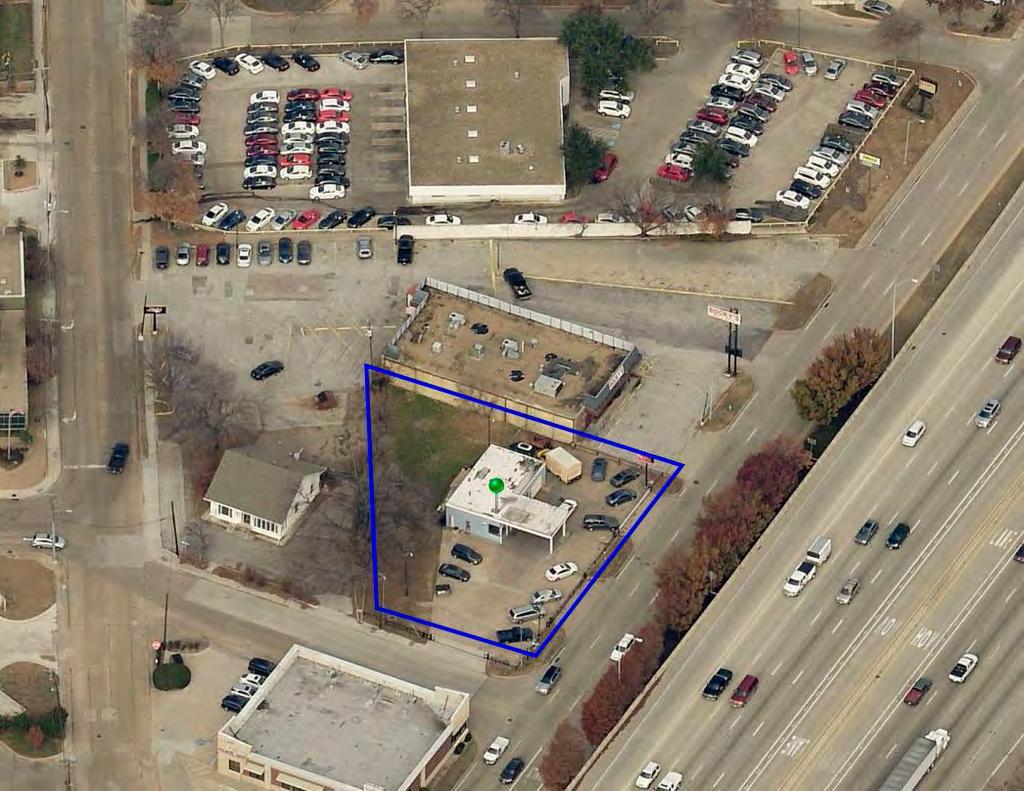
102

103
City of Richardson Zoning Board of Adjustment Agenda Packet August 16, 2017
 City of Richardson Zoning Board of Adjustment Agenda Packet August 16, 2017 To advance to the background material for each item in the agenda, click on the item title in the agenda or click on Bookmarks
City of Richardson City Plan Commission Agenda Packet Tuesday, October 16, 2018
 City of Richardson City Plan Commission Agenda Packet Tuesday, October 16, 2018 To advance to the background material for each item in the agenda, click on the item title in the agenda or click on Bookmarks
ORDINANCE NO
 ORDINANCE NO. 16-024 AN ORDINANCE OF THE CITY OF UNIVERSITY PARK, TEXAS, AMENDING THE COMPREHENSIVE ZONING ORDINANCE AND MAP OF THE CITY OF UNIV~ RSITY PARK, AS HERETOFORE AMENDED, BY CREATING PLANNED
City of Richardson City Plan Commission Agenda Packet Tuesday, November 7, 2017
 City of Richardson City Plan Commission Agenda Packet Tuesday, November 7, 2017 To advance to the background material for each item in the agenda, click on the item title in the agenda or click on Bookmarks
CITY OF TYLER CITY COUNCIL COMMUNICATION
 CITY OF TYLER CITY COUNCIL COMMUNICATION Agenda Number: Z-2 Date: January 23, 2019 Subject: PD18-035 FAIR NANCY WOOD (2801 AND 2835 SOUTH BROADWAY AVENUE) Request that the City Council consider approving
City of Richardson City Plan Commission Agenda Packet Tuesday, December 20, 2016
 City of Richardson City Plan Commission Agenda Packet Tuesday, December 20, 2016 To advance to the background material for each item in the agenda, click on the item title in the agenda or click on Bookmarks
ORDINANCE NO BE IT ORDAINED BY THE CITY COUNCIL OF THE CITY OF RICHARDSON, TEXAS:
 ORDINANCE NO. 3719 AN ORDINANCE OF THE CITY OF RICHARDSON, TEXAS AMENDING THE COMPREHENSIVE ZONING ORDINANCE OF THE CITY OF RICHARDSON, AS HERETOFORE AMENDED, ADDING ARTICLE XXII-G TO ESTABLISH A NEIGHBORHOOD
CITY OF RICHARDSON CITY PLAN COMMISSION MINUTES NOVEMBER 15, 2016 APPROVED
 CITY OF RICHARDSON CITY PLAN COMMISSION MINUTES NOVEMBER 15, 2016 The Richardson City Plan Commission met on, at 7:00 p.m. at City Hall in the Council Chambers, 411 W. Arapaho Road, Richardson, Texas.
applicant; and JBI Partners, Inc., surveyor /engineer; have submitted a planned
 1 2 3 4 5 6 7 8 10 11 13 14 151 16 1 22 23 24 25 26 27 ORDINANCE NO. 16 AN ORDINANCE OF THE CITY COUNCIL OF THE CITY OF KELLER, TEXAS, AMENDING THE UNIFIED DEVELOPMENT CODE OF THE CITY OF KELLER, TEXAS,
AGENDA BURLESON PLANNING AND ZONING COMMISSION February 10, 2015 BURLESON CITY HALL 141 W. RENFRO BURLESON, TX 76028
 AGENDA BURLESON PLANNING AND ZONING COMMISSION BURLESON CITY HALL 141 W. RENFRO BURLESON, TX 76028 REGULAR SESSION 6:00 p.m. Call to Order Invocation Pledge of Allegiance 1. Consent Agenda All items listed
AGENDA PLANNING COMMISSION Tuesday, April 18, :00 PM City Council Chambers 125 East Avenue B, Hutchinson, Kansas
 AGENDA PLANNING COMMISSION Tuesday, April 18, 2017 5:00 PM City Council Chambers 125 East Avenue B, Hutchinson, Kansas 1. ROLL CALL Macklin Woleslagel Bisbee (Chair) Hamilton Peirce Vacant Carr Hornbeck
AGENDA ZONING BOARD OF ADJUSTMENT August 10, :00 pm BURLESON CITY HALL 141 W. RENFRO BURLESON, TX 76028
 AGENDA ZONING BOARD OF ADJUSTMENT August 10, 2017 6:00 pm BURLESON CITY HALL 141 W. RENFRO BURLESON, TX 76028 Call to Order - 6:00 pm 1. Approve the minutes from the July 20, 2016 meeting. 2. Public hearing
City of Richardson City Plan Commission Agenda Packet Tuesday, February 16, 2016
 City of Richardson City Plan Commission Agenda Packet Tuesday, February 16, 2016 To advance to the background material for each item in the agenda, click on the item title in the agenda or click on Bookmarks
City of Richardson City Plan Commission Agenda Packet Tuesday, September 6, 2016
 City of Richardson City Plan Commission Agenda Packet Tuesday, September 6, 2016 To advance to the background material for each item in the agenda, click on the item title in the agenda or click on Bookmarks
ORDINANCE NO AMENDING CHAPTER 94 OF THE CODE OF ORDINANCES OF THE ORDINANCE, TEXAS), AS HERETOFORE AMENDED, BY AMENDING; RELATING
, AS HERETOFORE AMENDED, BY AMENDING; RELATING") ORDINANCE NO. 3513 AN OF THE CITY OF FARMERS BRANCH, TEXAS ORDINANCE AMENDING CHAPTER 94 OF THE CODE OF ORDINANCES OF THE CITY OF FARMERS BRANCH ( THE COMPREHENSIVE ZONING ORDINANCE, TEXAS), AS HERETOFORE
ORDINANCE NO. 3513 AN OF THE CITY OF FARMERS BRANCH, TEXAS ORDINANCE AMENDING CHAPTER 94 OF THE CODE OF ORDINANCES OF THE CITY OF FARMERS BRANCH ( THE COMPREHENSIVE ZONING ORDINANCE, TEXAS), AS HERETOFORE
ACTION FORM BRYAN CITY COUNCIL
 ACTION FORM BRYAN CITY COUNCIL DATE OF COUNCIL MEETING: July 8, 2014 DATE SUBMITTED: June 17, 2014 DEPARTMENT OF ORIGIN: Development Services SUBMITTED BY: Maggie Dalton MEETING TYPE: CLASSIFICATION: ORDINANCE:
CITY OF HIGHLAND VILLAGE, TEXAS ORDINANCE NO
 CITY OF HIGHLAND VILLAGE, TEXAS ORDINANCE NO. 2014-1172 AN ORDINANCE OF THE CITY OF HIGHLAND VILLAGE, TEXAS, AMENDING THE COMPREHENSIVE ZONING ORDINANCE OF THE CITY OF HIGHLAND VILLAGE AS PREVIOUSLY AMENDED,
mandatory injunction to remove any previous violation hereof.
 ORDINANCE NO. 2013-10- 099 AN ORDINANCE OF THE CITY COUNCIL OF THE CITY OF McKINNEY, TEXAS, AMENDING THE ZONING MAP OF THE CITY OF McKINNEY, TEXAS; SO THAT AN APPROXIMATELY 41. 64 ACRE PROPERTY IS REZONED
City of Richardson City Plan Commission Agenda Packet March 6, 2012
 City of Richardson City Plan Commission Agenda Packet March 6, 2012 To advance to the background material for each item in the agenda, click on the item title in the agenda or click on Bookmarks in the
Town of Holly Springs Town Council Meeting Agenda Cover Sheet
 Town of Holly Springs Town Council Meeting Agenda Cover Sheet Meeting Date: Feb. 19, 2019 Agenda Item #: 8c Agenda Placement: Public Hearing (Recognitions (awards, proclamations), Requests & Communications
LOCATION MAP: AERIAL PHOTOGRAPH, 2015:
 LOCATION MAP: AERIAL PHOTOGRAPH, 2015: ORDINANCE NO. AN ORDINANCE OF THE CITY OF BRYAN, TEXAS, AMENDING CHAPTER 130, ZONING, OF THE CITY OF BRYAN CODE OF ORDINANCES, BY CHANGING THE ZONING CLASSIFICATION
M E M O R A N D U M. Meeting Date: October 23, Item No. F-1. Planning and Zoning Commission. Daniel Turner, Planner I
 M E M O R A N D U M Meeting Date: October 23, 2017 Item No. F-1 To: From: Subject: Planning and Zoning Commission Daniel Turner, Planner I PUBLIC HEARING: Consider a recommendation of a of Planned Development
CITY PLAN COMMISSION STAFF REPORT
 CITY PLAN COMMISSION STAFF REPORT SUBJECT: Request for a Change of Zoning and Preliminary Development Plan FROM: Mara Perry, Director of Planning & Development MEETING DATE: November 6, 2017 PETITION:
City of Richardson City Plan Commission Agenda Packet June 7, 2011
 City of Richardson City Plan Commission Agenda Packet June 7, 2011 To advance to the background material for each item in the agenda, click on the item title in the agenda or click on Bookmarks in the
COMPREHENSIVE ZONING ORDINANCE OF THE CITY OF ROCKWALL AS HERE-
 ORDNANCE NO. 82-22 AN ORDNANCE OF THE CTY OF ROCKt'JALL TEXAS, AMENDNG THE COMPREHENSVE ZONNG ORDNANCE OF THE CTY OF ROCKWALL AS HERE- TOFORE AMENDED SO AS TO CHF.NGE TRACTS AND TO PD PLANNED DEVELOPMENT
AGENDA BARTONVILLE TOWN COUNCIL SPECIAL MEETING. September 26, 2018 BARTONVILLE TOWN HALL, 1941 E. JETER, BARTONVILLE, TX :00 PM
 AGENDA BARTONVILLE TOWN COUNCIL SPECIAL MEETING September 26, 2018 BARTONVILLE TOWN HALL, 1941 E. JETER, BARTONVILLE, TX 76226 A. CALL SPECIAL MEETING TO ORDER B. PLEDGE OF ALLEGIANCE 7:00 PM C. PUBLIC
AGENDA BURLESON PLANNING AND ZONING COMMISSION January 22, 2015 BURLESON CITY HALL 141 W. RENFRO BURLESON, TX 76028
 AGENDA BURLESON PLANNING AND ZONING COMMISSION BURLESON CITY HALL 141 W. RENFRO BURLESON, TX 76028 REGULAR SESSION 6:00 p.m. Call to Order Invocation Pledge of Allegiance 1. Consent Agenda All items listed
ORDINANCE NO. Be it ordained by the City Council of the City of Abilene, Texas:
 ORDINANCE NO. An ordinance repealing Chapter 23, Subpart B of the Code of the City of Abilene, Texas, entitled Mobile Homes and Vacation Travel Trailers; stating the authority; setting forth the scope
City of Richardson City Plan Commission Agenda Packet July 19, 2011
 City of Richardson City Plan Commission Agenda Packet July 19, 2011 To advance to the background material for each item in the agenda, click on the item title in the agenda or click on Bookmarks in the
AGENDA PLANNING COMMISSION Tuesday, February 7, :00 PM City Council Chambers 125 East Avenue B, Hutchinson, Kansas
 AGENDA PLANNING COMMISSION Tuesday, February 7, 2017 5:00 PM City Council Chambers 125 East Avenue B, Hutchinson, Kansas 1. ROLL CALL Macklin Woleslagel Bisbee (Chair) Hamilton Peirce Obermite Carr Hornbeck
M E M O R A N D U M. Meeting Date: April 9, Item No. F-1. Planning and Zoning Commission. Scott Bradburn, Planner I
 M E M O R A N D U M Meeting Date: April 9, 2018 Item No. F-1 To: From: Subject: Planning and Zoning Commission Scott Bradburn, Planner I PUBLIC HEARING: Consider a recommendation for a Specific Use Permit
CITY OF LAKE WORTH PLANNING AND ZONING COMMISSION AGENDA 3805 ADAM GRUBB LAKE WORTH, TEXAS TUESDAY, FEBRUARY 19, 2019
 CITY OF LAKE WORTH PLANNING AND ZONING COMMISSION AGENDA 3805 ADAM GRUBB LAKE WORTH, TEXAS 76135 TUESDAY, FEBRUARY 19, 2019 REGULAR MEETING: 6:30 PM Held in the City Council Chambers A. CALL TO ORDER A.1
k-. ..,.,.-- ORDINANCE NO. 894
 ORDINANCE NO. 894 I k-. \La. AN ORDINANCE OF THE CITY OF MESQUITE, TEXAS, AMENDING! THE COMPREHENSIVE ZONING ORDINANCE OF 1964, DULY PASSED BY THE CIm COUNCIL ON AUGUST 3.7, 1964. SO AS TO GRANT A CHANGE
City Council Agenda Memo
 City Council Agenda Memo TO: FROM: Robert Hanna, City Manager Jon James, AICP Director of Planning and Development Services City Council Meeting Date: 5/28/2015 SUBJECT: First reading on an ordinance for
M E M O R A N D U M. Meeting Date: May 1, Item No. H-4. Steve Polasek, Interim City Manager. David Hawkins, Senior Planner
 M E M O R A N D U M Meeting Date: May 1, 2012 Item No. H-4 To: From: Subject: Steve Polasek, Interim City Manager David Hawkins, Senior Planner PUBLIC HEARING: Consider an ordinance approving a planned
TOWNSHIP OF NEPTUNE NOTICE OF FINAL ADOPTION OF ORDINANCE ORDINANCE NO
 TOWNSHIP OF NEPTUNE NOTICE OF FINAL ADOPTION OF ORDINANCE ORDINANCE NO. 17-13 AN ORDINANCE AUTHORIZING DEED OF EASEMENT AND RIGHT-OF-WAY AGREEMENT FOR SEWER LINE PURPOSES WITH NEW YORK CONCOURSE, LLC AND
specifically described as Exhibit "A" attached hereto and made a part hereof; and
 CITY OF ROCKWALL ORDINANCE NO. 06-20 AN ORDINANCE OF THE CITY COUNCIL OF THE CITY OF ROCKWALL, TEXAS, AMENDING THE UNIFIED DEVELOPMENT CODE OF THE CITY OF ROCKWALL, AS PREVIOUSLY AMENDED, SO AS TO CHANGE
NOTICE OF A REGULAR MEETING OF THE ENID-GARFIELD COUNTY METROPOLITAN AREA PLANNING COMMISSION
 NOTICE OF A REGULAR MEETING OF THE ENID-GARFIELD COUNTY METROPOLITAN AREA PLANNING COMMISSION Notice is hereby given that the Enid-Garfield County Metropolitan Area Planning Commission will meet in regular
REPORT TO PLANNING & ZONING COMMISSION - CITY OF MARYLAND HEIGHTS
 APPLICATION NUMBER APPLICATION (PROJECT) NAME APPLICANT NAME PROPERTY OWNER NAME CUP16-0003 CENTRAL POWER SYSTEMS & SERVICES, INC. Central Power Systems & Services, Inc. 900 Liberty Drive, Liberty, MO
Department of Planning & Development Services
 Department of Planning & Development Services S T A F F R E P O R T February 9, 2015 CASE NO: PROJECT: EXECUTIVE SUMMARY: ZA14-154 Plat Revision for Lots 25R-1A, 25R-1B and 25R-1C, Block 1, Woodland Heights
City Council Agenda Memo
 City Council Agenda Memo TO: FROM: Larry D. Gilley, City Manager Jon James, AICP Director of Planning and Development Services City Council Meeting Date: 10/7/2013 SUBJECT: Final reading and public hearing
2/16/2016. City Council City Hall Wilmington, North Carolina Dear Mayor and Councilmembers:
 ITEM O1 2/16/2016 OFFICE OF THE CITY MANAGER (910) 341-7810 FAX(910)341-5839 TDD (910)341-7873 City Council City Hall Wilmington, North Carolina 28401 Dear Mayor and Councilmembers: Attached for your consideration
TOWN OF FLOWER MOUND, TEXAS ORDINANCE NO.
 TOWN OF FLOWER MOUND, TEXAS ORDINANCE NO. 58-12 AN ORDINANCE OF THE TOWN COUNCIL OF THE TOWN OF FLOWER MOUND, TEXAS, AMENDING THE OFFICIAL ZONING MAP, EXHIBIT "A" OF SUBPART B, LAND DEVELOPMENT REGULATIONS,
LEMOORE PLANNING COMMISSION Regular Meeting AGENDA Lemoore Council Chamber 429 C Street. May 14, :00 p.m.
 LEMOORE PLANNING COMMISSION Regular Meeting AGENDA Lemoore Council Chamber 429 C Street May 14, 2018 7:00 p.m. 1. Pledge of Allegiance 2. Call to Order and Roll Call 3. Public Comment This time is reserved
STAFF REPORT. Lee County School Board APPLICANT/PROPERTY OWNER DOCKET/CASE/APPLICATION NUMBER
 STAFF REPORT ZA17-0012 DOCKET/CASE/APPLICATION NUMBER Wyatt Daltry, AICP, Planning Team Coordinator (239) 573-3160, wdaltry@capecoral.net STAFF PLANNER Lee County School Board APPLICANT/PROPERTY OWNER
TOWNSHIP OF UPPER MACUNGIE LEHIGH COUNTY, PENNSYLVANIA. ORDINANCE NO [To be considered for Adoption June 1, 2017]
![TOWNSHIP OF UPPER MACUNGIE LEHIGH COUNTY, PENNSYLVANIA. ORDINANCE NO [To be considered for Adoption June 1, 2017]](/thumbs/91/106428876.jpg "TOWNSHIP OF UPPER MACUNGIE LEHIGH COUNTY, PENNSYLVANIA. ORDINANCE NO [To be considered for Adoption June 1, 2017]") TOWNSHIP OF UPPER MACUNGIE LEHIGH COUNTY, PENNSYLVANIA ORDINANCE NO. 2017 05 [To be considered for Adoption June 1, 2017] AN ORDINANCE OF THE BOARD OF SUPERVISORS OF THE TOWNSHIP OF UPPER MACUNGIE, LEHIGH
TOWNSHIP OF UPPER MACUNGIE LEHIGH COUNTY, PENNSYLVANIA ORDINANCE NO. 2017 05 [To be considered for Adoption June 1, 2017] AN ORDINANCE OF THE BOARD OF SUPERVISORS OF THE TOWNSHIP OF UPPER MACUNGIE, LEHIGH
ZONING BOARD OF ADJUSTMENTS (ZBOA) MEETING AGENDA
 MEETING AGENDA") ZONING BOARD OF ADJUSTMENTS (ZBOA) MEETING AGENDA Notice is hereby given of a Regular Meeting of the La Porte Zoning Board of Adjustments to be held on Thursday, April 27, 2017 at 6:00 p.m. at City Hall
ZONING BOARD OF ADJUSTMENTS (ZBOA) MEETING AGENDA Notice is hereby given of a Regular Meeting of the La Porte Zoning Board of Adjustments to be held on Thursday, April 27, 2017 at 6:00 p.m. at City Hall
ORDINANCE NO. NOW, THEREFORE, BE IT ORDAINED BY THE CITY COUNCIL OF THE CITY OF BRYAN, TEXAS:
 LOCATION MAPS: ORDINANCE NO. AN ORDINANCE OF THE CITY OF BRYAN, TEXAS, AMENDING CHAPTER 130, ZONING, OF THE CITY OF BRYAN CODE OF ORDINANCES, BY CHANGING THE ZONING CLASSIFICATION FROM AGRICULTURAL - OPEN
RECOMMENDATION Following the public hearing, consider Zoning Case PD14-16, with a Development Plan.
 Staff Report Zoning Case PD14-16 (Helzer Tract) Planning and Zoning Meeting Date: 12-17-14 Document Being Considered: Ordinance RECOMMENDATION Following the public hearing, consider Zoning Case PD14-16,
July 18, 2017 Planning & Zoning Meeting 6:30 p.m.
 July 18, 2017 Planning & Zoning Meeting 6:30 p.m. Date: July 18, 2017 PLANNING AND ZONING MEETING ATTENDANCE LIST Commissioners Position Present Absent R.G. Reeder Bill Bonham Greg Smith Leslie Boudwin
M E M O R A N D U M. Meeting Date: April 19, Item No. H-2. Mark Hafner, City Manager. Michele Berry, Planner II
 M E M O R A N D U M Meeting Date: April 19, 2016 Item No. H-2 To: From: Subject: Mark Hafner, City Manager Michele Berry, Planner II PUBLIC HEARING: Consider an ordinance approving a Specific Use Permit
ORDINANCE NO. O-5-10
 ORDINANCE NO. O-5-10 AN ORDINANCE OF THE TOWN COMMISSION OF THE TOWN OF PALM BEACH SHORES, FLORIDA, AMENDING THE TOWN CODE OF ORDINANCES AT APPENDIX A. ZONING. SECTION VI. DISTRICT B REGULATIONS BY AMENDING
1. Roll Call. 2. Minutes a. September 26, 2016 Regular Meeting. 3. Adoption of the Agenda. 4. Visitors to Be Heard
 1. Roll Call City of Vermillion Planning Commission Agenda 5:30 p.m. Regular Meeting Tuesday, October 11, 2016 Large Conference Room 2 nd Floor City Hall 25 Center Street Vermillion, SD 57069 2. Minutes
Also present were Bill Mann, Senior Planner and Senior Secretary Amber Lehman.
 held Monday, August 26, 2013, at 7:00 P.M. in the Council Chambers, 11 North 3 rd Street, Jacksonville Beach, Florida Call to Order The meeting was called to order by Chairman Greg Sutton. Roll Call Greg
Department of Planning & Development Services
 Department of Planning & Development Services S T A F F R E P O R T November 13, 2013 CASE NO: PROJECT: EXECUTIVE SUMMARY: DETAILS: ACTION NEEDED: ZA13-128 Zoning Change and Site Plan for Kimball Lake
AGENDA TOWN OF FLOWER MOUND OIL & GAS BOARD OF APPEALS MEETING JUNE 20, 2018 FLOWER MOUND TOWN HALL 2121 CROSS TIMBERS ROAD FLOWER MOUND, TEXAS
 AGENDA TOWN OF FLOWER MOUND OIL & GAS BOARD OF APPEALS MEETING JUNE 20, 2018 FLOWER MOUND TOWN HALL 2121 CROSS TIMBERS ROAD FLOWER MOUND, TEXAS 6:00 P.M. *************************************************************
PLANNING COMMISSION STAFF REPORT
 PLANNING COMMISSION STAFF REPORT West Capitol Hill Zoning Map Amendment Petition No. PLNPCM2011-00665 Located approximately at 548 W 300 North Street, 543 W 400 North Street, and 375 N 500 West Street
Synergy Park Addition (Companion to item 3)
") Synergy Park Addition (Companion to item 3) Attachments: 1. Locator 2. Replat staff report 3. Replat W P G r es rg eo e s Bu hh wy Lot 6A 4.02-acres Lot 4C 13.02-acres Fran k Lots 4C and 6A, Block A Synergy
Synergy Park Addition (Companion to item 3) Attachments: 1. Locator 2. Replat staff report 3. Replat W P G r es rg eo e s Bu hh wy Lot 6A 4.02-acres Lot 4C 13.02-acres Fran k Lots 4C and 6A, Block A Synergy
COMMUNICATION TOWERS ORDINANCE No. 31
 COMMUNICATION TOWERS ORDINANCE No. 31 ARTICLE 1: AUTHORITY AND JURISDICTION Authority Pursuant to the authority granted by 1967 SDCL 11-2 as amended; the following regulations are hereby adopted by the
City Council Agenda Memo
 City Council Agenda Memo TO: FROM: Larry D. Gilley, City Manager Jon James, AICP Director of Planning and Development Services City Council Meeting Date: 1/9/2014 SUBJECT: Final reading and public hearing
Planning and Zoning Commission STAFF REPORT REQUEST. DSA : Zone Change from R-3 (Multi-Family Residential) to B-4 (Community Services).
 to B-4 (Community Services).") Planning and Zoning Commission STAFF REPORT AGENDA # TO: FROM: PLANNING AND ZONING COMMISSION Joseph Horn, City Planner MEETING DATES: August 4, 2016 SUBJECT: Gino Tarantini zone change requests REQUEST
Planning and Zoning Commission STAFF REPORT AGENDA # TO: FROM: PLANNING AND ZONING COMMISSION Joseph Horn, City Planner MEETING DATES: August 4, 2016 SUBJECT: Gino Tarantini zone change requests REQUEST
Planning and Development Department. City of La Porte. Zoning Board of Adjustment Agenda
 City of La Porte Established 1892 Planning and Development Department Director Richard Mancilla City of La Porte Zoning Board of Adjustment Agenda Notice is hereby given of a Meeting of the La Porte Zoning
CITY OF DECATUR, TEXAS Development Services 1601 S. State Street Decatur, TX (940) voice (940) fax
 voice (940) fax") CITY OF DECATUR, TEXAS Development Services 1601 S. State Street Decatur, TX 76234 (940) 393-0250 voice (940) 626-4629 fax Call to Order AGENDA Planning and Zoning Commission Meeting* Tuesday, January
CITY OF DECATUR, TEXAS Development Services 1601 S. State Street Decatur, TX 76234 (940) 393-0250 voice (940) 626-4629 fax Call to Order AGENDA Planning and Zoning Commission Meeting* Tuesday, January
The minutes of the October 7, 201 4, meeting were approved on a m otion by Martin, seconded by Woleslagel, passed unanimously.
 1 MINUTES CITY PLANNING COMMISSION TUESDAY, OCTOBER 21, 2014 5:00 p.m. CITY COUNCIL CHAMBERS 125 EAST AVENUE B 1. The Planning Commission meeting was called to order with the following members present:
M-- I NUTES GLYNN COUNTY PLANNING COMMISSION OCTOBER 5, :00 A.M. Wayne Stewart, Chairman Georgia DeSain Glenda Jones Jack Kite Richard Parker
 M-- NUTES GLYNN COUNTY PLANNNG COMMSSON OCTOBER 5, 1993 9:00 A.M. PRESENT: ABSENT: ALSO PRESENT: STAFF PRESENT: Wayne Stewart, Chairman Georgia DeSain Glenda Jones Jack Kite Richard Parker ra Moore Lee
City of Richardson Zoning Board of Adjustment Agenda Packet September 20, 2017
 City of Richardson Zoning Board of Adjustment Agenda Packet September 20, 2017 To advance to the background material for each item in the agenda, click on the item title in the agenda or click on Bookmarks
The City Council of the City of Sulphur, Louisiana, met in special session at its
 July 12, 2018 The City Council of the City of Sulphur, Louisiana, met in special session at its regular meeting place in the Council Chambers, Sulphur, Louisiana, on July 12, 2018 at 5:00 p.m., after full
----':c RESOLUTION NO. ZR
 RESOLUTION NO. ZR-2018-015 RESOLUTION APPROVING ZONING APPLICATION ZV-2017-02395 CONTROL NO. 1980-00215 TYPE II VARIANCE (STAND ALONE) APPLICATION OF Gleneagles Country Club Inc BY WGINC, AGENT (GLENEAGLES
NYE COUNTY, NV PAHRUMP REGIONAL PLANNING COMMISSION REGULAR MEETING OCTOBER 12, 2016
 NYE COUNTY, NV PAHRUMP REGIONAL PLANNING COMMISSION REGULAR MEETING OCTOBER 12, 2016 Staff Report Agenda Item No. 10 CASE DESCRIPTION(S): For possible action ZC-2016-000009: Public hearing, discussion,
SCOTT TOWNSHIP-LACKAWANNA COUNTY, PA ORDINANCE NO
 SCOTT TOWNSHIP-LACKAWANNA COUNTY, PA ORDINANCE NO. 09-02-18-001 AN ORDINANCE OF THE TOWNSHIP OF SCOTT REQUIRING THE NUMBERING OF HOUSES AND BUILDINGS IN THE TOWNSHIP; REQUIRING THE NAMING OF STREETS AND
AGENDA BARTONVILLE PLANNING AND ZONING COMMISSION. Wednesday, June 6, 2018 BARTONVILLE TOWN HALL 1941 E. JETER ROAD, BARTONVILLE, TX :00 P.M.
 A. CALL TO ORDER AGENDA BARTONVILLE PLANNING AND ZONING COMMISSION Wednesday, June 6, 2018 BARTONVILLE TOWN HALL 1941 E. JETER ROAD, BARTONVILLE, TX 76226 7:00 P.M. B. PLEDGE OF ALLEGIANCE TO THE AMERICAN
Planning & Economic Development Department
 Planning & Economic Development Department SUBJECT: Second Consideration of Ordinances for 1601 Overlook Drive Glen Gate Shopping Center and Focus Development Apartments i.) First consideration of an Ordinance
the property is zoned A, Agricultural District; and
 Bill No. Requested by: Wayne Anthony Sponsored by: Joe Brazil Ordinance No. AN ORDINANCE GRANTING CONDITIONAL USE PERMIT CUP15-000006 FOR A NURSERY AND LAWN CARE SERVICE TO HOOPS LAWN & LANDSCAPING L.L.C.
AGENDA ITEM. Two Separate Public Hearings relating to the Eighth Avenue S./Orange Place Enclave Annexation
 DATE PREPARED: May 20, 2015 AGENDA ITEM PREPARED BY: Marisa M. Barmby, AICP, Senior Planner Central Florida Regional Planning Council AGENDA DATE: June 1, 2015 and June 8, 2015 REQUESTED ACTION: Two Separate
ZONING BOARD OF ADJUSTMENT AGENDA PACKET
 ZONING BOARD OF ADJUSTMENT AGENDA PACKET APRIL 18, 2012 AGENDA CITY OF RICHARDSON ZONING BOARD OF ADJUSTMENT APRIL 18, 2012 6:30 P.M. CIVIC CENTER/COUNCIL CHAMBERS 411 W. ARAPAHO ROAD STUDY SESSION: 6:00
City Council Agenda Memo. David A. Vela, Interim City Manager Jon James, AICP Director of Planning and Development Services
 City Council Agenda Memo TO: FROM: David A. Vela, Interim City Manager Jon James, AICP Director of Planning and Development Services City Council Meeting Date: 3/26/2015 SUBJECT: First reading on an ordinance
CITY PLANNING COMMISSION CITY OF NEW ORLEANS EXECUTIVE DIRECTOR. City Planning Commission Staff Report Executive Summary
 CITY PLANNING COMMISSION CITY OF NEW ORLEANS MITCHELL J. LANDRIEU MAYOR ROBERT D. RIVERS EXECUTIVE DIRECTOR LESLIE T. ALLEY DEPUTY DIRECTOR City Planning Commission Staff Report Executive Summary Zoning
REPORT TO PLANNING & ZONING COMMISSION - CITY OF MARYLAND HEIGHTS
 APPLICATION NUMBER APPLICATION (PROJECT) NAME APPLICANT NAME PROPERTY OWNER NAME CUP16-0013 POHLMAN, LLC Pohlman, LLC 140 Long Road, Chesterfield, Missouri 63005 JDDC, Ltd. 8677 Tyler Boulevard, Mentor,
CITY OF ALBERT LEA PLANNING COMMISSION ADVISORY BOARD
 CITY OF ALBERT LEA PLANNING COMMISSION ADVISORY BOARD 9/1/2015, 5:30 p.m. City Council Chambers AGENDA A. CALL TO ORDER AND ROLL CALL B. APPROVAL OF THE AGENDA C. APPROVAL OF MINUTES 1. PC Minutes from
AGENDA BURLESON PLANNING AND ZONING COMMISSION MEETING September 13, 2011 BURLESON CITY HALL 141 W. RENFRO BURLESON, TX 76028
 AGENDA BURLESON PLANNING AND ZONING COMMISSION MEETING BURLESON CITY HALL 141 W. RENFRO BURLESON, TX 76028 REGULAR SESSION 7:00 p.m. Call to Order Invocation All items listed below under 1. Consent Agenda
PD No. 15 Authorized Hearing
 PD No. 15 Authorized Hearing Community Meeting No. 2 February 19, 2019 6:30 p.m. Hyer Elementary School Cafetorium 8385 Durham St Andrew Ruegg Senior Planner PD No. 15 Authorized Hearing On September 7,
RESOLUTION R EAST COUNTY MIDDLE SCHOOL SCHOOL SITE PLAN SSP DTS
 RESOLUTION R-18-003 EAST COUNTY MIDDLE SCHOOL SCHOOL SITE PLAN SSP-17-02 DTS20170502 A RESOLUTION OF THE BOARD OF COUNTY COMMISSIONERS OF MANATEE COUNTY, FLORIDA, REGARDING LAND DEVELOPMENT; ALLOWING FOR
ZONING BOARD OF ADJUSTMENT AGENDA PACKET
 ZONING BOARD OF ADJUSTMENT AGENDA PACKET SEPTEMBER 21, 2011 AGENDA CITY OF RICHARDSON ZONING BOARD OF ADJUSTMENT SEPTEMBER 21, 2011 6:30 P.M. CIVIC CENTER/COUNCIL CHAMBERS 411 W. ARAPAHO ROAD STUDY SESSION:
Oakland County Michigan Register of Deeds Plat Engineering, GIS, & Remonumentation Dept. Ph: (248) Fax (248)
 Fax (248)") Oakland County Michigan Register of Deeds Plat Engineering, GIS, & Remonumentation Dept. Ph: (248)-858-1447 Fax (248)-858-7466 Requirements Needed for Final Plat Approval No. General Requirements. 1 Routing
Oakland County Michigan Register of Deeds Plat Engineering, GIS, & Remonumentation Dept. Ph: (248)-858-1447 Fax (248)-858-7466 Requirements Needed for Final Plat Approval No. General Requirements. 1 Routing
BOROUGH OF CARLISLE CUMBERLAND COUNTY, PENNSYLVANIA ORDINANCE NO. 2324
 BOROUGH OF CARLISLE CUMBERLAND COUNTY, PENNSYLVANIA ORDINANCE NO. 2324 AN ORDINANCE OF THE BOROUGH COUNCIL OF THE BOROUGH OF CARLISLE, CUMBERLAND COUNTY, PENNSYLVANIA, AUTHORIZING THE EXERCISE OF EMINENT
M E M O R A N D U M. Planning and Zoning Commission. Daniel Turner, Planner I
 M E M O R A N D U M Meeting Date: Monday, April 10, 2017 Item No. F-4 To: From: Planning and Zoning Commission Daniel Turner, Planner I Subject: Consider a recommendation of a Preliminary Site Evaluation
MINUTES JOINT MEETING LINCOLN COUNTY and SIOUX FALLS PLANNING COMMISSIONS 7:00 pm August 10, 2011
 MINUTES JOINT MEETING LINCOLN COUNTY and SIOUX FALLS PLANNING COMMISSIONS 7:00 pm August 10, 2011 Commissioners Room - Lincoln County Court House A joint meeting of the Lincoln County and Sioux Falls Planning
David L. Brown, Construction Services Manager
 Memorandum Date: 2/02/2013 Order Date: 2/27/2013 TO: DEPARTMENT: PRESENTED BY: AGENDA ITEM TITLE: Board of County s Public Works David L. Brown, Construction Services Manager In the Matter of Authorizing
Department of Planning & Zoning
 Department of Planning & Zoning M E M O R A N D U M TO: Brian Wismer, Planning Commission Chairman FROM: Bill Johnston, City Planner SUBJECT: DATE: Tuesday, 1 September 2015 FINDINGS Mr. Floyd Anderson,
AGENDA COMMITTEE OPENING OF. use. given the. by staff. CHAIRPERSON DALLAS BAKER CITY PLANNER OFFICIAL TODD MORRIS CHIEF BUILDING
 AGENDA CITY OF EL MONTE MODIFICATION COMMITTEE CITY OF EL MONTE MODIFICATION COMMITTEE CHAIRPERSON DALLAS BAKER PLANNING COMMISSION CITY PLANNER JASON C. MIKAELIAN CHIEF BUILDING OFFICIAL TODD MORRIS TUESDAY,
City of San Juan Capistrano Agenda Report
 City of San Juan Capistrano Agenda Report TO: Zoning Administrator FROM: Reviewed by: Sergio Klotz, AICP, Assistant Development Services DirctJ. o ~ Prepared by: Laura Stokes, Housing Coordinator I Assistant
RESOLUTION NO. ZR
 RESOLUTION NO. ZR-2019-003 RESOLUTION APPROVING ZONING APPLICATION ZV/ABN/PDD/W-2018-00548 (CONTROL NO. 1979-00106) TYPE 2 VARIANCE (CONCURRENT) APPLICATION OF Boca Pier Associates, LLC, Glades Road West
Lot 1 KAP Lot 1. Lot 1. Lot 4. ot 5
 Public Notice January 11, 2018 Subject Property: 237 Phoenix Avenue Lot 4, District Lot 5, Group 7 Similkameen Division Yale (Formerly Yale-Lytton) District, Plan 10974 Application: The applicant is proposing
PLANNING & ZONING COMMISSION MEETING THURSDAY, NOVEMBER 10, 2016 AT 6:30 P.M. JUSTIN CITY HALL 415 NORTH COLLEGE STREET JUSTIN, TEXAS 76247
 PLANNING & ZONING COMMISSION MEETING THURSDAY, NOVEMBER 10, 2016 AT 6:30 P.M. JUSTIN CITY HALL 415 NORTH COLLEGE STREET JUSTIN, TEXAS 76247 I. Call To Order: Invocation and Pledge of Allegiance. II. Public
CITY OF RAYTOWN Request for Board Action
 CITY OF RAYTOWN Request for Board Action Date: April 23, 2013 Bill No. 6316-13 To: Mayor and Board of Aldermen Section No: XIII From: John Benson, Director of Development and Public Affairs Department
VILLAGE OF JUSTICE ORDINANCE NO
 VILLAGE OF JUSTICE ORDINANCE NO. 2004-24 AN ORDINANCE ADOPTING THE FIRST PHASE OF THE VILLAGE OF JUSTICE COMPREHENSIVE PLAN FOR THE VILLAGE OF JUSTICE ZONING CODE, CREATING CHAPTER 12 ARTICLE II, DIVISION
ARTICLE 3: Zone Districts
 ARTICLE 3: Zone Districts... 3-1 17.3.1: General...3-1 17.3.1.1: Purpose and Intent... 3-1 17.3.2: Districts and Maps...3-1 17.3.2.1: Applicability... 3-1 17.3.2.2: Creation of Districts... 3-1 17.3.2.3:
NOTICE OF MEETING AND AGENDA FOR THE PLANNING COMMISSION OF SPRINGVILLE, UTAH... JANUARY 23, 2018
 NOTICE OF MEETING AND AGENDA FOR THE PLANNING COMMISSION OF SPRINGVILLE, UTAH............................ JANUARY 23, 2018 Notice is hereby given that the Planning Commission will hold a public meeting
2. Rezone a portion of the lot from R2 (Small Lot Residential) to RD2 (Duplex: Housing Lane).
 to RD2 (Duplex: Housing Lane).") Public Notice September 6, 2018 Subject Property Subject Property: 337 Hastings Ave Lot 24, District Lot 1, Group 7, Similkameen Division Yale (Formerly Yale-Lytton) District, Plan 932 Application: The
Public Notice September 6, 2018 Subject Property Subject Property: 337 Hastings Ave Lot 24, District Lot 1, Group 7, Similkameen Division Yale (Formerly Yale-Lytton) District, Plan 932 Application: The
A PUBLIC RIGHT-OF-WAY MANAGEMENT ORDINANCE BY THE CITY OF SOUTHLAKE, TEXAS; REGULATING THE PHYSICAL USE, OCCUPANCY AND MAINTENANCE
 ORDINANCE NO. 1178 A PUBLIC RIGHT-OF-WAY MANAGEMENT ORDINANCE BY THE CITY OF SOUTHLAKE, TEXAS; REGULATING THE PHYSICAL USE, OCCUPANCY AND MAINTENANCE OF CITY RIGHTS-OF-WAY BY WIRELESS NETWORK PROVIDERS;