CITY PLAN COMMISSION STAFF REPORT
|
|
|
- Justin Campbell
- 5 years ago
- Views:
Transcription

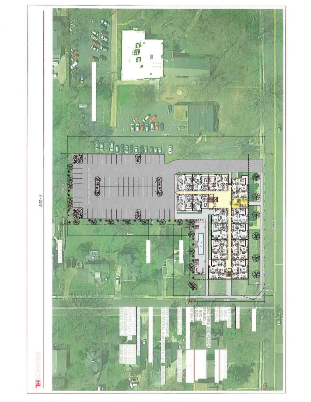
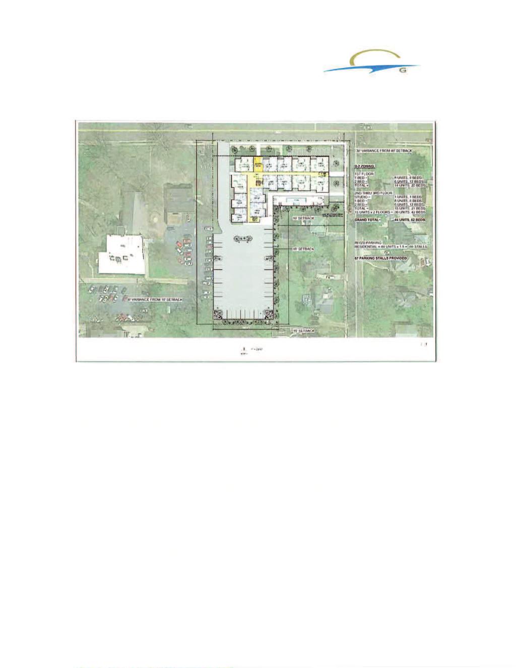
1 CITY PLAN COMMISSION STAFF REPORT SUBJECT: Request for a Change of Zoning and Preliminary Development Plan FROM: Mara Perry, Director of Planning & Development MEETING DATE: November 6, 2017 PETITION: 17-PC-21 Ridge House Apartments LOCATION: 226 E. Lockwood APPLICANT: Sangita Capital Partners Proposal Summary Sangita Capital Partners has submitted a request to rezone one property located at 226 E. Lockwood to a B1 Planned Multiple Family Residence District zoning with a Preliminary Development Plan. The subject property is currently zoned A1 Twenty Thousand Square Foot Residence District. The property encompasses approximately 1.47 acres of land at 226 E. Lockwood. The Preliminary Development Plan includes a three (3) story forty-four (44) unit multi-family residential development. The total square footage of the proposed structure is 52,590 square feet. The Preliminary Development Plan also includes sixty-seven (67) parking spaces. Requested Action The City Plan Commission is requested to review the application for a Change of Zoning and Preliminary Development Plan and to make a recommendation to City Council. A public hearing before City Council is tentatively scheduled for November 21, Land Use and Zoning History of Subject Site The subject property was zoned A One-Family and B Two-Family according to early zoning maps of the City from In 1956, the property was changed to be A 20,000 Square Foot Residence District. According to St. Louis County records, the YMCA building was built in 1958 shortly after the City adopted their 1956 zoning code. The code at that time would have required a Special Use Permit for the use within the A 20,000 square foot residence district. Records regarding this property from the 1950s are not all complete in the City records. Staff had been unable to find a Special Use Permit for the YMCA. Upon further research, information was obtained through minutes of the City Council and Plan Commission. The records indicate that the YMCA had a building on the western portion of the Page 1 of 14


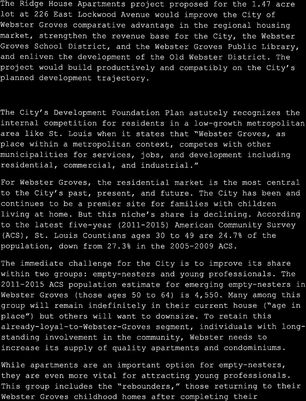
2 property and later obtained the corner property on Sylvester. A request was before the City Plan Commission on March 18, 1957 for approval of construction of a larger building. According to the minutes, it was determined that it should come before the City Council three days later with a written application for a Special Use Permit. It was also discussed a review of the need for a variance that would need to be requested before the Board of Adjustment. A request was before the City Council on March 21, 1957 to build a building on the Y.M.C.A. property. According to the minutes, the application was referred back to the City Plan Commission. On March 27, 1957, the application was recommended for approval of a Special Use Permit and the need for a variance to be requested before the Board of Adjustment. On April 4, 1957, the City Council discussed advertising for a public hearing on the matter on May 2, On the night of the Public Hearing, the City Council voted to recommend the permit however no ordinance number was assigned and no official Special Use Permit appears to have been drafted. On May 7, 1957, the YMCA was before the Board of Adjustment to review a request for a variance to the front yard setback. The variance request was granted for a front yard setback of thirty (30) feet for the property. View looking west along Lockwood Ave. View looking east along Lockwood Ave. View looking south at the existing parking lot View looking north through the corner of the site Page 2 of 14


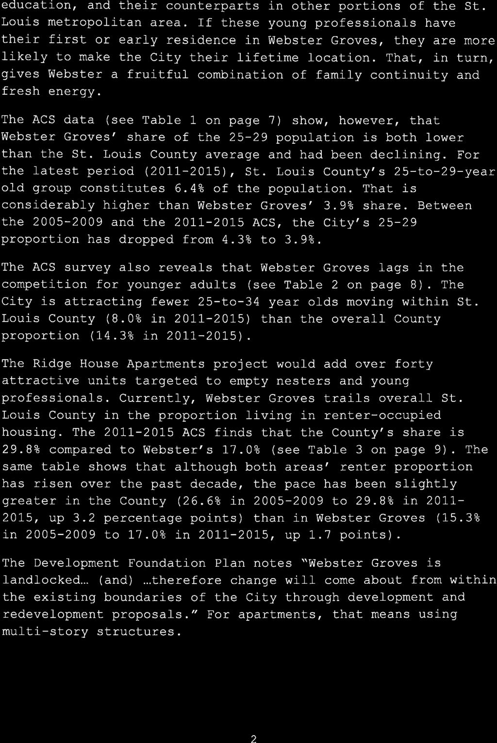
3 View looking south at the existing building View looking east at the existing building View looking west at the existing building & parking lot View looking south at the rear of the property Land Use and Zoning of Surrounding Properties North: The properties to the north are zoned A1 Twenty Thousand Square Foot Residence District and include single family homes and the Webster Groves Library and library parking lot. South: The property to the south is zoned A1 Twenty Thousand Square Foot Residence District and A3 Ten Thousand Square Foot Residence District and contains single family homes. East: The property to the east is the zoned A1 Twenty Thousand Square Foot Residence District and A3 Ten Thousand Square Foot Residence District and contains single family homes. West: The property to the west is zoned A1 Twenty Thousand Square Foot Residence District and is the Shining Rivers School and the parking lot shared by the school and the Peace United Church of Christ. Page 3 of 14


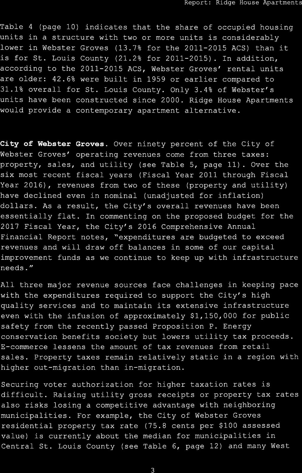
4 Zoning Map 2016 Aerial Photograph Comprehensive Plan Analysis The 1978 Comprehensive Plan is a guiding document for the City of Webster Groves. It was amended in 2006 to address key commercial areas within the City although the two documents were never formally consolidated. The 1978 Comprehensive Plan contains key Community Objectives, a series of Community Policies and then a summary of the priorities for the community. Page 4 of 14


5 Under the Community Objectives, the overriding objective is development and maintenance of a residential community. A series of Community Policies were adopted in order to reach the objectives/goals of the community. The first policy identified was To Maintain Residential Values and Amenities. The first item under that policy was related to the Zoning Ordinance. Staff wanted to provide clarification on that item as many residents have been referencing this first item with regard to this rezoning request. The Zoning Ordinance is part of the City Code which identifies the various allowable zoning districts. The Comprehensive Plan was written in 1978 and since that time no new residential standards have been relaxed through an amendment or created for multi-family dwellings. The B1 and B2 Districts were adopted by the City Council in the 1963 and No changes have been amended in the Zoning Ordinance regarding these districts since that date. Another item under the first community policy discussed apartments and townhouses. Two maps have been provided below. The first is a cropped section of the 1978 Comprehensive Plan Map showing the areas along Lockwood Avenue and Big Bend Boulevard. The second is a City map showing current uses today Comprehensive Plan Map Current Map of the City showing Existing Uses Page 5 of 14
6 As identified on the previous maps, most of the multi-family residential facilities are located adjacent to the commercial areas of the City. Under the Maintain Residential Values and Objectives it identifies: Apartments or townhouses should be permitted (or encouraged) adjacent to the three commercial areas (Lockwood-Gore, Elm Avenue, and Old Orchard). The Land Development Objective identifies that: In Webster Groves apartment locations are appropriate only: 1. Within or near commercial areas, or 2. In developments of large institutional properties where overall density is not increased and multiple-family uses enable open space to be saved. The units over the years have been a mix of owner occupied and rental and the size of units has varied. The policy identifies and encourages a unit size which was never listed in any Multi-Family requirements of the Zoning Ordinance. Other sections of the zoning ordinance identify square footage requirements for residential. Not providing a coordinated amendment to the zoning ordinance in 1978 to match this policy is an issue. The 1978 Comprehensive Plan also discussed former institutional properties which included schools, religious institutions and other public or semi-public uses. The text of the document stated that In the future some institutions may desire to devote their properties to different uses. Any new use should be carefully considered in relation to its impact on the surrounding neighborhood, as well as its effects on the long-range general welfare of the city as a whole. The plan also identifies that The city has been a single-family residential community throughout its history. and that If a reasonable number of apartments, town houses or condominiums could be built in appropriate location, the elderly persons or families could move into these, stay in the city, and their house made available for younger families. The Development Foundation Plan in 2006 was an amendment to the 1978 Comprehensive Plan but it did not consolidate the two documents into one. The former YMCA property was never addressed in the 2006 amendment. The comprehensive plan map was amended earlier in 2017 to address the fact that the 1978 comprehensive plan map had never been consolidated with the maps from the Development Foundation Plan. Based on the objectives in the comprehensive plan staff recommended changing the comprehensive plan map from public or semi-public which would have only allowed another institution on the property. The comprehensive plan map was amended in this area to show multiple family residential giving multiple options for the property while still preserving the option of an institution on the property. The proposed zoning amendment is in compliance with the comprehensive plan. ZONING ANALYSIS Staff has reviewed the proposed rezoning with permitted and conditional uses allowed in a B1 Planned Multiple Family Residence District. The B1 Planned Multiple Family Residence District regulations are contained in Sec et seq. Development must be in accordance with a Development Plan, which may be filed with or subsequent to the rezoning. The intent of the planned multi-family zoning is to provide for apartments of integrated design in appropriate locations and Each development in any such district shall be laid out and developed as a unit, according to an approved plan. The B1 Planned Multiple Family Residence District requires that a plan for this type of development be referred to the Plan Commission for study, public hearing and report. The Plan Commission is to determine the suitability of the request based on the regulations of the district. Page 6 of 14
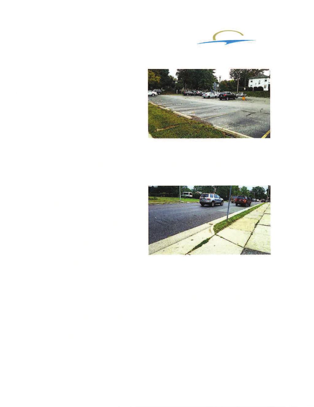
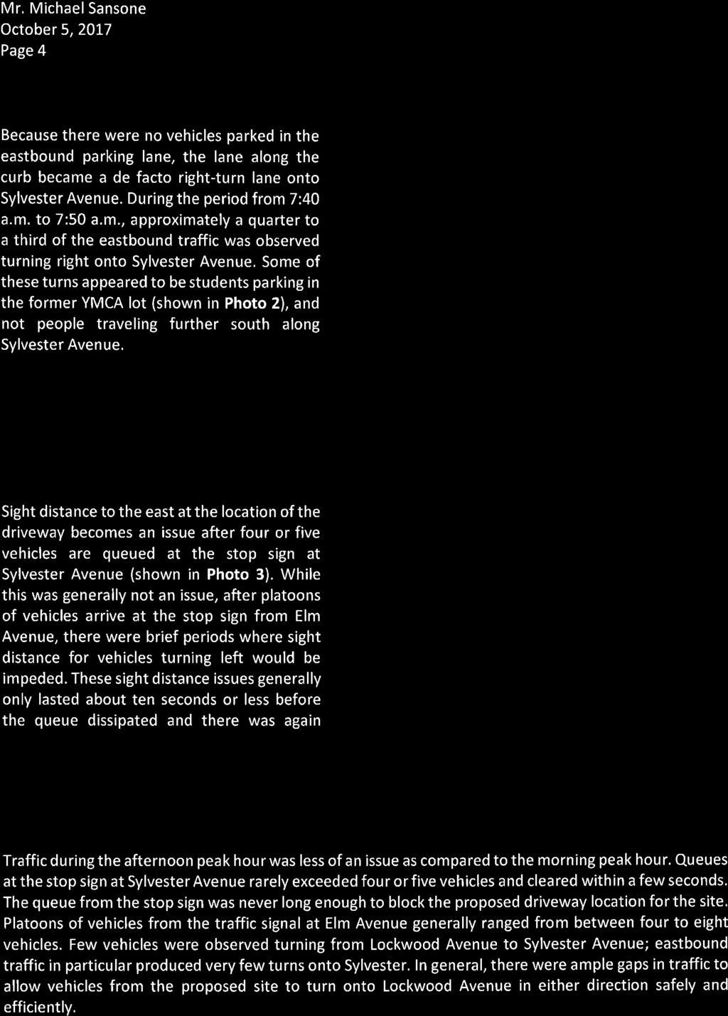
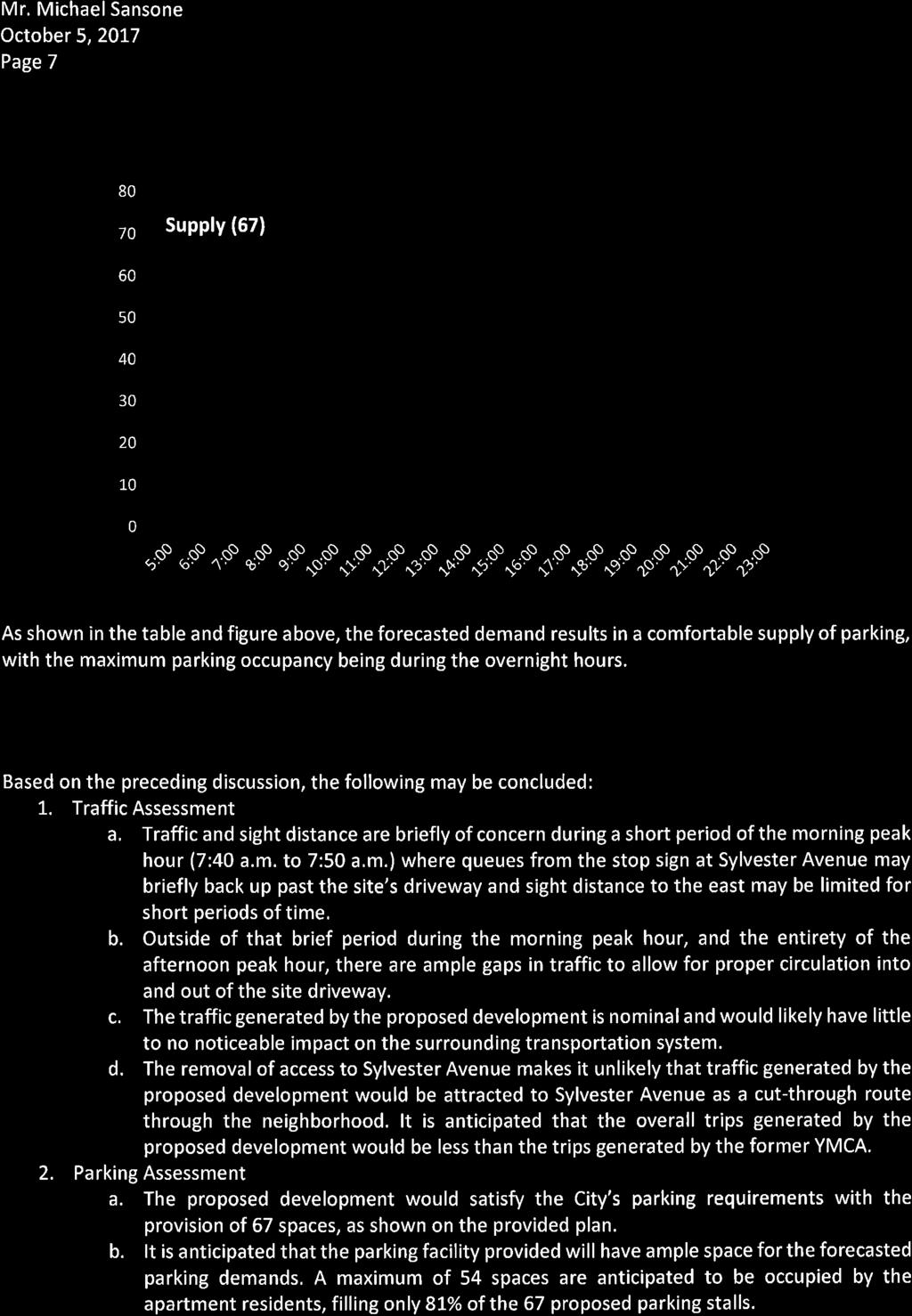
7 STAFF ANALYSIS Permitted, Conditional and Accessory Uses Within a B1 Planned Multiple Family Residence District, a building or premises may be used for apartments of integrated design that are to be developed as a unit according to an approved plan. The proposal identifies a total of forty-four (44) new apartments and parking for the development. The area is to be designed as a whole, unified, single project in compliance with the minimum requirements of the code. The intent of this development is to build all aspects in one phase. Staff recommends providing a limitation on the number of units in the ordinance for the development. Parking The site currently has a forty (40) parking space lot located on the northeast corner of the property which had been used for the YMCA. Access to the parking lot was provided only from Sylvester Avenue with two curb cuts. Parking had typically overflowed onto adjacent streets. If the YMCA was being built today, it would have required a minimum of ninety-eight (98) parking spaces based on the square footage of the building and the use type. The existing parking lot is proposed to be removed and parking relocated to the rear of the lot with access from the curb cut location on Lockwood Avenue. Staff has reviewed the information provided by the applicant and has determined the number of parking spaces required per code. Use Type Parking Requirements Required Parking Dwelling Unit 1 ½ spaces for each dwelling 44 dwelling units x 1 1/2 = 66 unit spaces TOTAL = 66 spaces required The proposed development plan identifies a total of sixty-seven (67) parking spaces being provided on the site. The basic layout shows landscape islands and a buffer to the east and south. During final development plan review, all landscape buffers and islands will be verified to meet the dimensional regulations of the Tree and Landscape Ordinance. Per the code, no driveway or parking space is allowed to be closer than ten (10) feet from any side or rear property line. The proposed plan shows the parking area meeting this requirement on all sides with the exception of the western property line. Staff will identify later in the report the variance powers under this type of zoning for the Plan Commission. Access and Circulation Current access to the site includes two curb cuts off Sylvester Avenue and one off Lockwood Avenue. The two access points off Sylvester serve the existing parking lot. The curb cut off Lockwood Avenue serves the rear of the building and connects into the lot for the Shining Rivers school building. The Preliminary Development Plan proposes that all access from Sylvester Avenue be removed and only the access point off Lockwood Avenue to remain. The Page 7 of 14
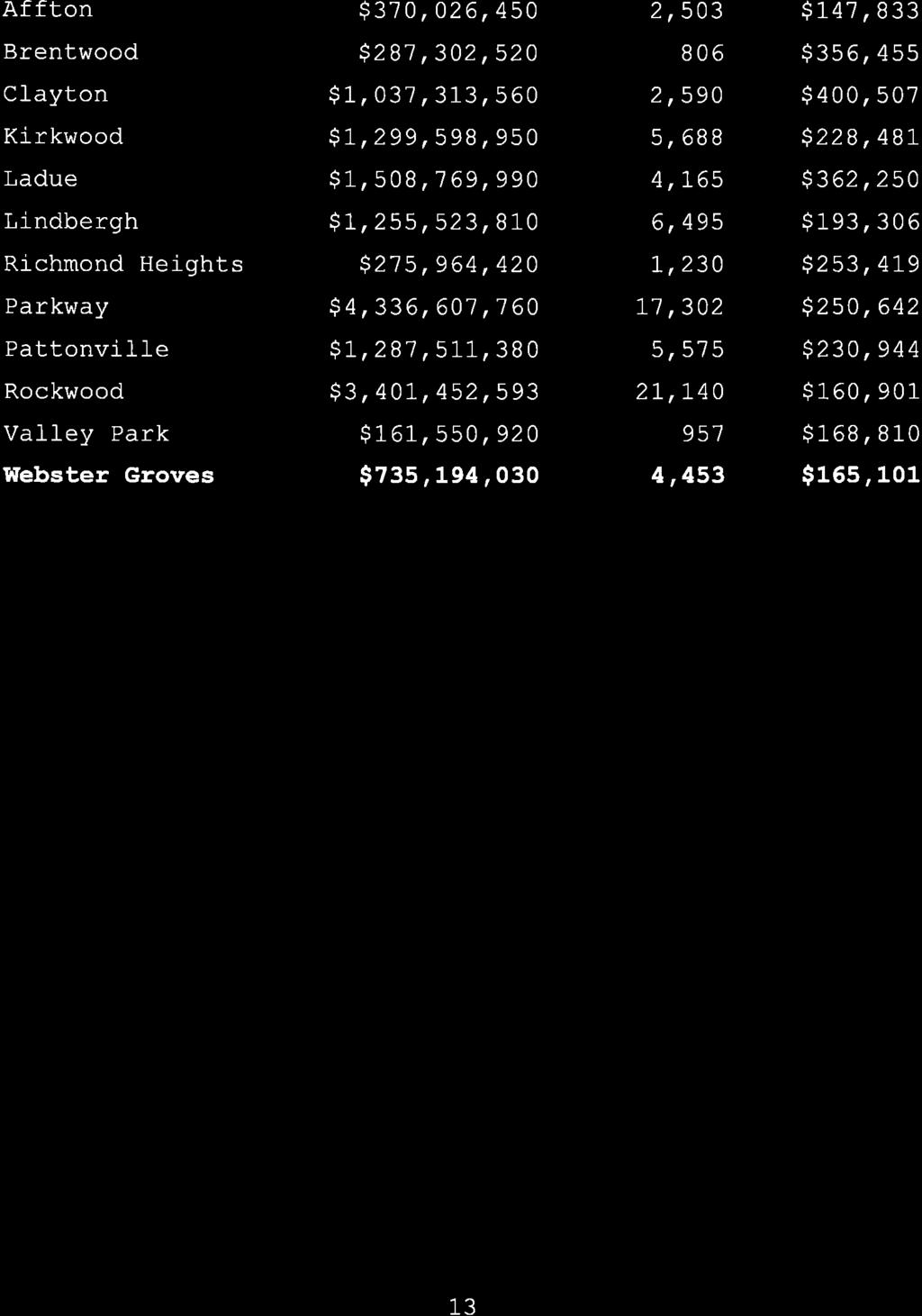
8 access would no longer connect to the parking lot to the west and would provide exclusive ingress and egress for the proposed parking lot. Staff reviewed traffic counts the City has on file for East Lockwood Avenue. The proposed development is in the 200 block of East Lockwood between Sylvester Avenue and Plant Avenue. Traffic Counts have been taken within two to three blocks of this property along Lockwood six times in the last twenty years. The traffic count numbers have been generally steady throughout that time. Based on comments during the Plan Commission meeting in August 2017, staff requested that the Public Works Department place traffic counters out to verify that numbers have remained steady over the years. The counts were taken over a four to seven day time frame and over 24 hour periods. Block/address Date Average Daily Traffic location 200 Block Lockwood June ,601 ADT (7 day) 100 Block of Lockwood April ,508 ADT (6 day) Lockwood at Selma August ,899 ADT (6 day) Lockwood at Selma September ,419 ADT (6 day) 301 E. Lockwood January ,786 ADT (5 day) 200 Block of 4,055 Eastbound 8,329 ADT (4 day March 2009 Lockwood 4,274 Westbound combined) 221 E. Lockwood September ,988 Eastbound 7,864 ADT (6 day 330 E. Lockwood September ,876 Westbound combined) All of these counts with the exception of the 2017 counts were taken when the YMCA was in full operation and would have included some of the daily counts of cars coming to and from the facility. The numbers have remained steady over the decades ranging from 7,500 through 8,600 over the last twenty years. Staff obtained a copy of the Institute of Transportation Engineers Common Trip Generation Rates for the PM Peak Hour (from the Trip Generation Manual 9 th edition). Those rates were used to compare the amount of trips generated for the proposed development as compared to a typical recreation facility like the YMCA. As a study of the trip generation was not performed prior to the closing of the YMCA, this provided a way to analyze a potential need for further traffic study. Code & Use Trips per unit of measure 220 Apartment 0.62 trips per dwelling unit 495 Recreational 1.45 trips per 1,000 Community Center sq. ft. 492 Health/Fitness Club 3.35 trips per 1,000 sq. ft. 493 Athletic Club 5.96 trips per 1,000 sq. ft. Trips 51 dwelling units x 0.62 = trips 29,507 sq. ft./1,000 x 1.45 = trips 29,507 sq. ft./1,000 x 3.35 = trips 29,507 sq. ft./1,000 x 5.96 = trips Page 8 of 14
9 The former YMCA was more than just a recreational community center with the fitness classes and the pool. It however was not really a full athletic club and likely did not generate that number of trips. Staff believes that the number of trips generated by the former YMCA exceeded the number of potential trips for the proposed development. Staff did not feel that additional study was required for traffic based on the former use of the site. After the August Plan Commission meeting, the applicants hired Lochmueller Group to provide a traffic and parking assessment. This was undertaken using the newest proposal information. Staff with the City have reviewed the assessment and found it in keeping with the original conclusion that no additional requirements would be required for access or circulation on the site. Tree Preservation and Landscaping A Tree Preservation Plan is required per section for any development that requires site plan approval; with the demolition of an existing primary structure or construction of a new primary structure. All three of these requirements hold for this development therefore requiring a Tree Preservation Plan. Documentation will be reviewed during the site plan review stage for review of the existing trees on the site and the proposed landscaping. A five (5) foot perimeter landscape buffer is required around new parking lots with more than twenty-one (21) parking spaces. With the ten (10) foot setback requirement in the B1 zoning for parking areas, the buffer will be met on the eastern and southern sides of the lot. The western side of the parking lot and the variance powers under this type of zoning for the Plan Commission will be discussed later in the report. Additional parking lot islands and landscaping will need to meet the specifications in of the City Code. Proposed trash enclosures will need to meet the screening requirements of the code. The Buildings Grounds section of the code will require landscaping based on the amount of building footprint facing streets, sidewalks and parking areas. Should there not be enough space on the property to landscape to the full requirement, a reduction in the landscaping can be approved by the Director of Planning and Development in consultation with the Park Manager. The proposed landscape plan will be reviewed with the site development plan. Dimensional Regulations The Planned Multiple Family Residence District has a series of dimensional regulations which are established to control the development. o Height The B1 regulations allow for the height of buildings to not exceed three stories with an additional exception to four stories for buildings with a footprint of less than twenty (20) percent. The proposed structure meets this requirement as it is proposed at three (3) stories. o Intensity of Use The B1 regulations require a series of calculations to ensure the overall intensity of the development on the lot. Lot coverage and minimum land area per unit are the two that control the size of the building or buildings on the lot. The building coverage is the percentage of the footprint of the building in relation Page 9 of 14

 The calculated requirement shows the maximums and minimums allowed per the code.")


10 to total area of the lot. The Minimum land area includes an amount of land per family which equates to the dwelling units. The analysis of the intensity regulations are shown in the chart below. Building Coverage Regulation Maximum 30% of Tract of Land Land Area Minimum of 1,200 square feet per family Calculation of requirement 1.47 acres X.30 = 19, square feet Maximum 44 dwelling units X 1,200 square feet = 52,800 square feet (1.212 acres) Proposed Plan 17,530 square feet 1.47 acres = 64,033.2 square feet (1,455.3 square feet per dwelling unit) The calculated requirement shows the maximums and minimums allowed per the code. The proposed development does not come close to the maximums for the building coverage and it also exceeds the minimum requirements for land area. Based on the preliminary development plan, ordinance regulations can be drafted to limit the development to the levels proposed. Staff would recommend placing a maximum square footage slightly exceeding the amount shown on the application. This would allow for continued development of the architectural design of the building and not hinder that design while meeting the overall massing proposed. o Setbacks Front, Side and Rear yard setbacks are established in the regulations of the code. Due to the unusual shape of the lot, Staff has provided a drawing to show the required setback locations. The proposed development intends to meet both the side and rear yard setbacks. They are requesting a variance to the front yard setbacks on both Sylvester Avenue Page 10 of 14
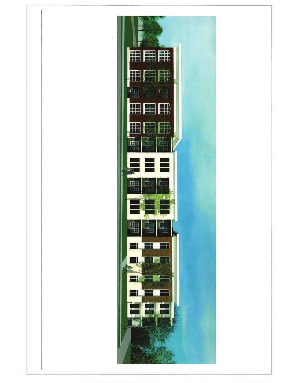
11 and Lockwood Avenue. Staff will identify later in the report the variance powers under this type of zoning for the Plan Commission. The proposed plan shows the footprint of the building exceeding the setbacks on multiple property lines of the tract of land. Staff would recommend that Plan Commission establish additional setbacks for the side and rear should this Preliminary Development Plan be approved. o Other Dimensional Regulations At this time none of the other dimensional regulations are applicable. All retaining walls or yard projections will need to meet the regulations of the Planned Multiple Family Residence District. Performance Standards The code has a small number of performance standards in the Planned Multiple Family Residence District. They are applicable as follows: o All parking areas and walkways are proposed to be paved with a hard surfaced material and will meet the City specifications. o The development is not proposing to expand on any existing structures. o All areas not used for buildings, parking, loading or access ways will be landscaped with grass, trees, shrubs and where applicable pedestrian walks. The Tree Preservation and Landscape Ordinance will apply to this and address the landscape requirements. o The Plan Commission has the ability to make recommendations to the City Council on additional requirements for landscaping, lighting, screening, access ways, building distances and yard limitations for the protection of nearby residential uses. Staff has made some recommendations in a few sections of the zoning analysis as recommendations for regulations in the ordinance. o If the City Plan Commission or Council believes proof of financial responsibility of the applicant, or developer, is in the best interests of the City, they may require the applicant to submit such proof to the Director of Finance for her approval. Lighting The building code requires that the level of lighting from any source shall not exceed 0.5 footcandles at any residential property line (Section AM102). Staff would recommend that in addition to that, shielding should be required on the parking lot lighting. The shielding will address any direct visual of the light fixtures from adjacent residential properties. The building code also allows for lights on poles to be a maximum of twenty-five (25) feet tall (Section AM103). At this time staff does not have a specific recommendation to lower that height. Placement on the detailed lighting plan to ensure proper light levels at property lines and shielding could warrant taller poles. Architectural Review Board The rendering of the building and detailed footprint are developed at this time to help establish recommendations for the ordinance for the planned development. The details of the look of the building will need to go before the Architectural Review Board per the regulations of Chapter 56 of the City Code. Staff does not recommend making the renderings as shown Page 11 of 14
12 exhibits to the ordinance for anything other than intensity of use for the overall massing of the building on the site. Variances The Planned Multiple Family Residence District provides that the Plan Commission can recommend to the City Council variances or modifications to the requirements of the code. It is intended when the strict enforcement of which would entail unusual or real difficulties in carrying out the intent of B1 District requirements. The City Council can approve, modify or reject those recommendations. Two variances are being requested from the regulations of the code by the applicant. Both are setback regulations. o Parking Setback The parking setback is established to require a minimum of ten (10) feet from the side or rear property lines. The Proposed Plan identifies the parking along the western property line as being a zero (0) setback. The adjacent property currently has an existing row of parking almost up to the property line. The intent of the code is to provide some buffering of parking areas from other uses. Along this property line it would be buffering one parking lot from another parking lot. Staff does not see any issues with varying this section of the code as it helps to provide buffers to the other adjacent residential uses while still providing the required parking for the development. It would be recommended that the setback variance be limited to the area of the parking lot and not to the drive aisle being provided. This will allow for a separation of the curb cuts for safety purposes as well o Front Yard Setback The code requires a minimum of forty (40) feet from the front property line as a setback from the street. The proposed plan identifies a thirty (30) foot setback from both streets. Staff was able to identify through further review that the property had received a variance to the front yard setback on Lockwood from the Board of Adjustment (BOA) in Variances through the BOA run with the land and remain with the property. Staff has determined that the setback from Lockwood does not need a variance through the rezoning as it had already been granted by the BOA. The development would still need to request a Plan Commission variance of the thirty (30) foot setback from Sylvester. For taller structures, the distance to a roadway for fire protection is an important requirement in code considerations. Closer proximity to Sylvester Avenue and Lockwood Avenue would allow the fire truck to have better ladder access from all four sides of the building. Other B zoned districts have provided driveways and drops off locations within the forty (40) foot setback. This development does not propose any curb cuts or vehicular access along the front of the proposed building. Staff does believe this is a reasonable variance to the code in providing other buffering from setbacks along adjacent single family residential. Additional regulations for setbacks to ensure the buffering can be included in the ordinance. Page 12 of 14
13 Comments from Other Departments The application request for the Rezoning was distributed to the Building Commissioner, Police, Fire, Parks and Public Works Departments. The Public Works Department had comments related to the existing sidewalks and changes to curb cuts along both Lockwood Avenue and Sylvester Avenue. Those comments have been integrated into the Staff recommendation to meet City and ADA standards. All other department comments will be addressed when the plans are reviewed during site plan and building permit review to meet all current code requirements for the uses proposed. Staff Recommendation Staff recommends approval of the application of the rezoning and preliminary development plan. Should the Plan Commission wish to forward this to the City Council with a recommendation of approval staff would recommend the following conditions to be placed on this rezoning: 1. All provisions of the City Code shall apply except as expressly modified in this Ordinance No.. 2. The permitted uses for this B1 Multiple Family Planned Residential District shall be limited as follows: a. Forty-Four (44) dwelling units. 3. Total Square footage of the structure shall not exceed 52,700 square feet. 4. A minimum of sixty-six (66) parking spaces will be provided on the site. 5. Any lighting shall be shielded so that the source of the light is not visible from adjacent residential properties as detailed on a lighting plan approved by the Director of Planning and Development. 6. The sidewalks along Sylvester Avenue and Lockwood Avenue shall be replaced as directed by the Director of Public Works. Sidewalk criteria shall be in accordance with the City of Webster Groves specifications and current ADA regulations including the two (2) percent cross slope maximum. The curb cut on Lockwood Avenue shall be installed to meet City Standards. The new ADA ramp at the corner of Lockwood Avenue and Sylvester Avenue should be maintained or replaced to meet ADA Standards. 7. The structure setbacks shall be the following: a. Thirty (30)-ft front yard setback from Sylvester Avenue b. Thirty (30)-ft front yard setback from Lockwood Avenue c. Two Hundred (200)-ft rear yard setback from the southern property line d. Twenty (20)-ft side yard setback from the southern property line adjacent to 9 Sylvester Avenue e. Twenty (20)-ft side yard setback from the eastern property line f. Twenty (20)-ft side yard from the western property line Page 13 of 14
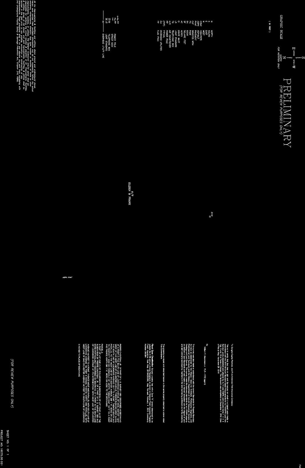
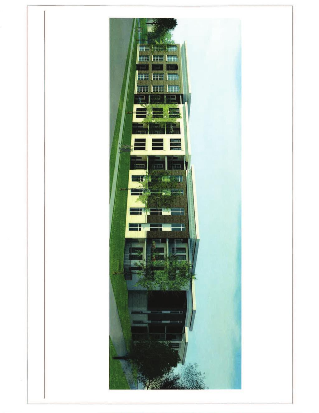
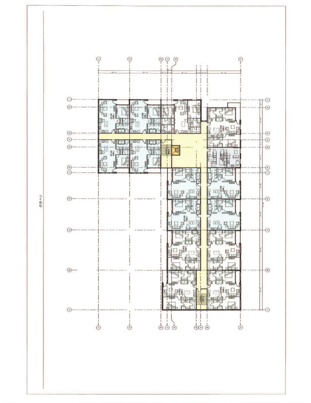
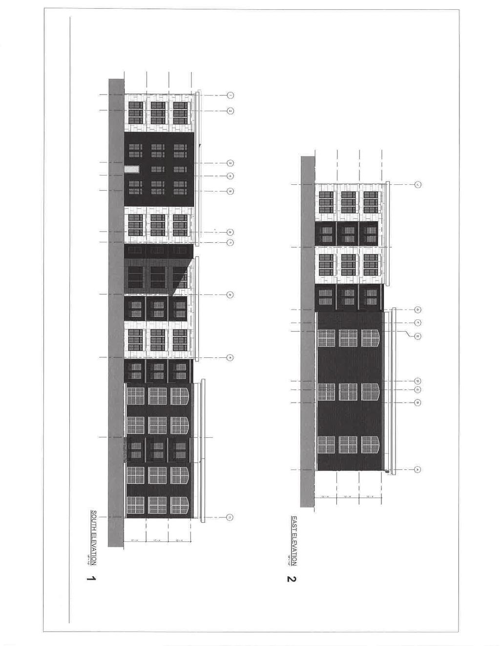
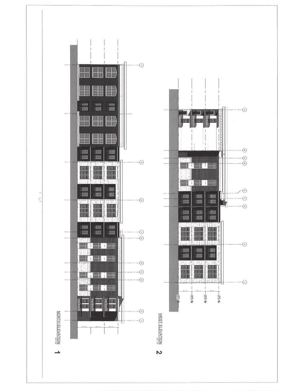
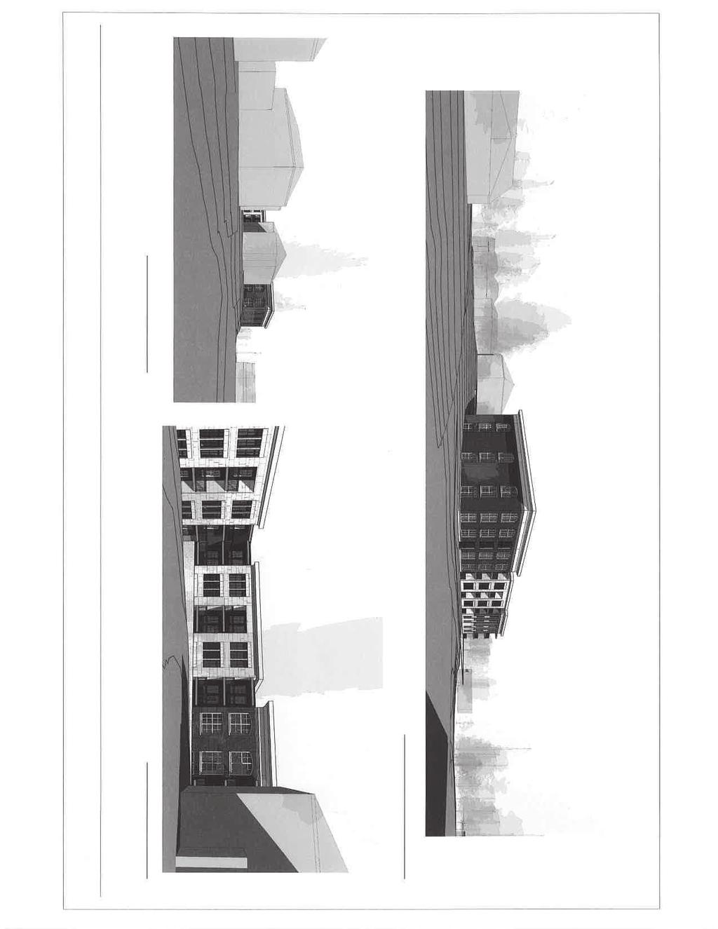
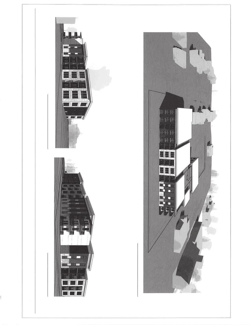
14 8. The parking setbacks shall be the following: a. Ten (10)-ft setback from the southern property lines b. Ten (10)-ft setback from the eastern property line c. Zero (0)-ft setback from the western property line along the southern parking lot with the setback increasing to ten (10)-ft along the entrance drive into the development from Lockwood Action Action on the rezoning will be in the form of a motion for approval, approval with conditions or denial. A public hearing for this application before City Council is tentatively scheduled for November 21, Attachments: 1. Summary of the request from Sangita Capital Partners received October 9, Ridge House Apartments: The Impact on Webster Groves report by E. Terrance Jones and Cynthia J. Palazzolo dated October ALTA/NSPS Land Title Survey Dated November 28, Two Color renderings of the proposal dated October 6, Preliminary Development Plan dated October 6, Second and Third Floor Plan dated October 6, Two sheets of Elevations dated October 6, Two sheets of perspectives dated October 6, Traffic and Parking Assessment from the Lochmueller Group dated October 5, 2017 Page 14 of 14
15
16
17
18
19
20

21
22
23
24
25
26
27
28

29
30
31
32
33
34

35
36

37

38
39
40
41
42
43
44
45
46
47

48
49

50
51
52
53
54
55
CITY PLAN COMMISSION STAFF REPORT
 CITY PLAN COMMISSION STAFF REPORT SUBJECT: FROM: MEETING DATE: February 6, 2017 PETITION: LOCATION: APPLICANT: Request for a Conditional Use Permit and Preliminary Development Plan Mara Perry, Director
CITY PLAN COMMISSION STAFF REPORT
 CITY PLAN COMMISSION STAFF REPORT SUBJECT: Request for Approval of an Amended Final Development Plan FROM: Mara Perry, Director of Planning & Development MEETING DATE: June 5, 207 PETITION: 7-PC-9 DJH
R E S O L U T I O N. 2. Development Data Summary:
 R E S O L U T I O N WHEREAS, the Prince George s County Planning Board has reviewed Special Permit Application No. SP-170001, Mama s Care Assisted Living Facility, requesting to expand an existing congregate
RP-2, RP-3, RP-4, AND RP-5 PLANNED RESIDENTIAL DISTRICTS
 6.10 - RP-2, RP-3, RP-4, AND RP-5 PLANNED RESIDENTIAL DISTRICTS 6.10.1 GENERAL DESCRIPTION: 6.10.1.1 The regulations established in this Section are intended to provide optional methods of land development
Article 7: Residential Land Use and Development Requirements
 Article 7: Residential Land Use and Section 701: Statement of Intent (A) (B) (C) The intent of Article 7 is to develop certain land use and development requirements for the residential uses within Cumru
Medical Marijuana Special Exception Use Information
 Medical Marijuana Special Exception Use Information The Special Exception Use information below is a modified version of the Unified Development Code. It clarifies the current section 5:104 Special Exceptions
3. Section is entitled Accessory Buildings ; limited applicability/regulation.
 MEMORANDUM DATE: October 9, 2017 TO: FROM: RE: Chairperson Hetzel, PC Commissioners, and Interim Administrator Meyer Cynthia Smith Strack, Community Development Director 6.1 Discussion: Detached Accessory
M E M O R A N D U M. Meeting Date: October 23, Item No. F-1. Planning and Zoning Commission. Daniel Turner, Planner I
 M E M O R A N D U M Meeting Date: October 23, 2017 Item No. F-1 To: From: Subject: Planning and Zoning Commission Daniel Turner, Planner I PUBLIC HEARING: Consider a recommendation of a of Planned Development
PLANNING AND ZONING COMMISSION AGENDA MEMORANDUM
 City and County of Broomfield, Colorado PLANNING AND ZONING COMMISSION AGENDA MEMORANDUM To: Planning and Zoning Commission From: John Hilgers, Planning Director Anna Bertanzetti, Principal Planner Meeting
PLANNED RESIDENTIAL DEVELOPMENT (PRD)
") PLANNED RESIDENTIAL DEVELOPMENT SECTION 10. PLANNED RESIDENTIAL DEVELOPMENT (PRD) 10.1 Purpose Planned Residential Development allows by special permit from the Board an alternative pattern of residential
PLANNED RESIDENTIAL DEVELOPMENT SECTION 10. PLANNED RESIDENTIAL DEVELOPMENT (PRD) 10.1 Purpose Planned Residential Development allows by special permit from the Board an alternative pattern of residential
ARTICLE 24 PRIVATE ROAD, SHARED PRIVATE DRIVEWAY AND ACCESS EASEMENT STANDARDS
 ARTICLE 24 PRIVATE ROAD, SHARED PRIVATE DRIVEWAY AND ACCESS EASEMENT STANDARDS SECTION 24.00 INTENT AND PURPOSE The standards of this Article provide for the design, construction and maintenance of private
Section 1: US 19 Overlay District
 Section 1: US 19 Overlay District Section 1.1 Intent and Purpose The purpose of the US Highway 19 Overlay District is to manage access to land development along US Highway 19 in a manner that preserves
DEVELOPMENT DEPARTMENT STAFF REPORT THE PARK AT 5 TH
 DEVELOPMENT DEPARTMENT STAFF REPORT ARB Meeting Date: July 3, 2018 Item #: _PZ2018-293_ THE PARK AT 5 TH Request: Site Address: Project Name: Parcel Number: Applicant: Proposed Development: Current Zoning:
9. REZONING NO Vicinity of the northwest corner of 143 rd Street and Metcalf Avenue
 9. REZONING NO. 2002-15 Vicinity of the northwest corner of 143 rd Street and Metcalf Avenue 1. APPLICANT: Andrew Schlagel is the applicant for this request. 2. REQUESTED ACTION: The applicant is requesting
SECTION 822 "R-1-A" AND "R-1-AH" - SINGLE FAMILY RESIDENTIAL DISTRICTS
 SECTION 822 "R-1-A" AND "R-1-AH" - SINGLE FAMILY RESIDENTIAL DISTRICTS The "R-1-A" and "R-1-AH" Districts are intended to provide for the development of single family residential homes at urban standards
Georgetown Planning Department
 Georgetown Planning Department Zoning Board of Adjustment Staff Report Meeting Date: March 19, 2013 Item: 4 File No: VAR-2013-002 Project Planner: Mike Elabarger, Senior Planner Report Date: March 14,
May 12, Chapter RH HILLSIDE RESIDENTIAL ZONES REGULATIONS Sections:
 May 12, 2017 Chapter 17.13 RH HILLSIDE RESIDENTIAL ZONES REGULATIONS Sections: 17.13.010 Title, intent, and description. 17.13.020 Required design review process. 17.13.030 Permitted and conditionally
(a) Commercial uses on Laurel Avenue, abutting the TRO District to the
 Commercial uses on Laurel Avenue, abutting the TRO District to the") 32X Zoning Code 150.36 TRANSITIONAL RESIDENTIAL OVERLAY DISTRICT. (A) Intent and purpose. (1) It is the intent of the Transitional Residential Overlay District (hereinafter referred to as the "TRO District")
32X Zoning Code 150.36 TRANSITIONAL RESIDENTIAL OVERLAY DISTRICT. (A) Intent and purpose. (1) It is the intent of the Transitional Residential Overlay District (hereinafter referred to as the "TRO District")
PALM BEACH COUNTY PLANNING, ZONING AND BUILDING DEPARTMENT ZONING DIVISION
 PALM BEACH COUNTY PLANNING, ZONING AND BUILDING DEPARTMENT ZONING DIVISION Application No.: DOA-2014-01111 Application Name: World Class Academy Control No.: 1998-00052 Applicant: World Class Academy Inc
UPPER MOUNT BETHEL TOWNSHIP NORTHAMPTON COUNTY, PENNSYLVANIA
 UPPER MOUNT BETHEL TOWNSHIP NORTHAMPTON COUNTY, PENNSYLVANIA JOINDER DEED / LOT CONSOLIDATION TOWNSHIP REVIEW PROCESS When accepting proposed Joinder Deeds / Lot Consolidations, review the Joinder Deed
City of Harrisburg Variance and Special Exception Application
 City of Harrisburg Variance and Special Exception Application Note: The Planning Bureau will review all applications for completeness; incomplete applications may cause a delay in processing. Contact Ben
ARTICLE IV DISTRICT REGULATIONS
 PART 1. RESIDENTIAL DISTRICTS 4-101. RS. Single-Family Residential Suburban District. The RS District is designed for single-family dwellings, and compatible uses, at a density no greater than one dwelling
CITY AND BOROUGH OF SITKA PLANNING AND COMMUNITY DEVELOPMENT DEPARTMENT VARIANCES
 CITY AND BOROUGH OF SITKA PLANNING AND COMMUNITY DEVELOPMENT DEPARTMENT VARIANCES VARIANCES WHAT? A variance is a waiver of development standards as outlined by municipal code. Variances may be sought
MIDDLETOWN TOWNSHIP PLANNING COMMISSION REGULAR MEETING MIDDLETOWN MUNICIPAL BUILDING WEDNESDAY, November 2, 2016
 MIDDLETOWN TOWNSHIP PLANNING COMMISSION REGULAR MEETING MIDDLETOWN MUNICIPAL BUILDING WEDNESDAY, November 2, 2016 PRESENT: ABSENT Sandy Farry George Hyjurick Charles Parkerson Fred Thomas Robert Burnet.
AN ORDINANCE OF THE CITY OF MINNEAPOLIS. By Palmisano
 AN ORDINANCE OF THE CITY OF MINNEAPOLIS By Palmisano Amending Title 20, Chapter 520 of the Minneapolis Code of Ordinances relating to Zoning Code: Introductory Provisions. The City Council of the City
ZONING ORDINANCE: OPEN SPACE COMMUNITY. Hamburg Township, MI
 ZONING ORDINANCE: OPEN SPACE COMMUNITY Hamburg Township, MI ARTICLE 14.00 OPEN SPACE COMMUNITY (Adopted 1/16/92) Section 14.1. Intent It is the intent of this Article to offer an alternative to traditional
THE AREA PLAN COMMISSION OF ST. JOSEPH COUNTY, IN AGENDA
 THE AREA PLAN COMMISSION OF ST. JOSEPH COUNTY, IN AGENDA Tuesday, January 17, 2017 Fourth-Floor Council Chambers 3:30 p.m. County-City Building, South Bend, IN EXECUTIVE SESSION: A. Election of Officers
Request Conditional Use Permit (Bulk Storage Yard) Conditional Rezoning (R-10 Residential to Conditional I-1 Light Industrial)
 Conditional Rezoning (R-10 Residential to Conditional I-1 Light Industrial)") Applicant and Property Owner Public Hearing December 12, 2018 City Council Election District Beach Agenda Item 6 Request Conditional Use Permit (Bulk Storage Yard) Conditional Rezoning (R-10 Residential
Applicant and Property Owner Public Hearing December 12, 2018 City Council Election District Beach Agenda Item 6 Request Conditional Use Permit (Bulk Storage Yard) Conditional Rezoning (R-10 Residential
Chapter 21 MOBILE HOME PARK REGULATIONS.
 Chapter 21 MOBILE HOME PARK REGULATIONS. Sec. 21.1 SCOPE. For the preservation of the interests of various types of residential developments which should be permitted in every community and for the protection
Division Development Impact Review.
 Division 51-4.800. Development Impact Review. SEC. 51-4.801. PURPOSE. The general objectives of this division are to promote and protect the health, safety, and general welfare of the public through the
Lacey UGA Residential density
 Thurston County Planning Department BOARD OF COUNTY COMMISSIONERS PUBLIC HEARING DRAFT AMENDMENTS TO THE CRITICAL AREAS REGULATIONS Residential density amendment to Title 21 Title 21 6/1/2012 Lacey UGA
MEMORANDUM. DATE: November 9, 2016 PC Agenda Item 3.C
 MEMORANDUM DATE: November 9, 2016 PC Agenda Item 3.C TO: FROM: SUBJECT: Planning Commission Eric Zweber, AICP, Interim City Planner Planning Case #16-029 Public Hearing Required Applicant: Bremer Bank,
PLANNED MIXED-USE DEVELOPMENT DISTRICT ( PMUD ) ZONING TEXT AMENDMENT
 ZONING TEXT AMENDMENT") PLANNED MIXED-USE DEVELOPMENT DISTRICT ( PMUD ) ZONING TEXT AMENDMENT Upon final approval of this PMUD zoning text amendment, development of the herein described property shall remain in strict compliance
PLANNED MIXED-USE DEVELOPMENT DISTRICT ( PMUD ) ZONING TEXT AMENDMENT Upon final approval of this PMUD zoning text amendment, development of the herein described property shall remain in strict compliance
CITY OF SIGNAL HILL SUBJECT: PUBLIC HEARING THE COURTYARD RESIDENTIAL DEVELOPMENT OF 10 CONDOMINIUMS AND A NEW SPECIFIC PLAN
 CITY OF SIGNAL HILL 2175 Cherry Avenue Signal Hill, CA 90755-3799 AGENDA ITEM TO: FROM: HONORABLE CHAIR AND MEMBERS OF THE PLANNING COMMISSION SELENA ALANIS ASSOCIATE PLANNER SUBJECT: PUBLIC HEARING THE
CHAPTER34 PRUD - PLANNED RESIDENTIAL UNIT DEVELOPMENT
 CHAPTER34 PRUD - PLANNED RESIDENTIAL UNIT DEVELOPMENT 17-34-1 17-34-2 17-34-3 17-34-4 17-34-5 17-34-6 17-34-7 17-34-8 17-34-9 Purpose Planned Residential Unit Development Defined Planned Residential Unit
Article 30: Residence Zones
 ARTICLE 30, Use Regulations Controlling Residence Zones 118-300. Island Conservation Zone. [Added effective 1-22-1974] A. Declaration of necessity and purpose. Article 30: Residence Zones (1) It is declared
PALM BEACH COUNTY PLANNING, ZONING AND BUILDING DEPARTMENT ZONING DIVISION
 PALM BEACH COUNTY PLANNING, ZONING AND BUILDING DEPARTMENT ZONING DIVISION Application No.: CA-2012-00688 Control No.: 2011-00552 Applicant: Garry Bernardo Owners: Garry Bernardo Agent: Frogner Consulting,
Report to the Plan Commission August 20, 2012
 Report to the Plan Commission Legistar I.D. #27376 5692-5696 Monona Drive Conditional Use Requested Action: Approval of a conditional use for an outdoor eating area for a restaurant and an accessory parking
Village of Glenview Plan Commission
 Village of Glenview Plan Commission STAFF REPORT May 13, 2014 TO: Chairman and Plan Commissioners CASE #: P2014-037 FROM: Community Development Department CASE MANAGER: Tony Repp, Planner SUBJECT: Final
City of Fairfax, Virginia City Council Public Hearing
 City of Fairfax, Virginia City Council Public Hearing Agenda Item # 8a City Council Meeting 1/27/2015 TO: Honorable Mayor and Members of City Council FROM: Robert Sisson, City Manager SUBJECT: Requests
PLANNING COMMISSION REPORT Regular Agenda -Public Hearing Item
 PDP-13-00518 Item No. 3B- 1 PLANNING COMMISSION REPORT Regular Agenda -Public Hearing Item PC Staff Report 2/24/14 ITEM NO. 3B PRELIMINARY DEVELOPMENT PLAN FOR HERE @ KANSAS; 1101 INDIANA ST (SLD) PDP-13-00518:
PLANNED UNIT DEVELOPMENT & SUBDIVISION STAFF REPORT Date: April 18, 2019
 PLANNED UNIT DEVELOPMENT & SUBDIVISION STAFF REPORT Date: April 18, 2019 DEVELOPMENT NAME SUBDIVISION NAME Springhill Village Subdivision Springhill Village Subdivision LOCATION 4350, 4354, 4356, 4358,
Cover Letter with Narrative Statement
 Cover Letter with Narrative Statement March 31, 2017 rev July 27, 2017 RE: Rushton Pointe Residential Planned Unit Development Application for Public Hearing for RPUD Rezone PL2015 000 0306 Mr. Eric Johnson,
FRONT YARD MP 35 FT 35 FT 10 FT A 20 FT A 2 35 FT 30% NOT PERMITTED NOT PERMITTED
 RESIDENTIAL/AGRICULTURAL COMMERCIAL/INDUSTRIAL ZONING DISTRICT Charter Township of Fort Gratiot Code of Ordinances Chapter 38-Zoning, Article III-District Regulations DIVISION 12. SCHEDULE OF DISTRICT
ARTICLE 14 PLANNED UNIT DEVELOPMENT (PUD) DISTRICT
 DISTRICT") ARTICLE 14 PLANNED UNIT DEVELOPMENT (PUD) DISTRICT Section 14.01 Intent. It is the intent of this Article to allow the use of the planned unit development (PUD) process, as authorized by the Michigan Zoning
ARTICLE 14 PLANNED UNIT DEVELOPMENT (PUD) DISTRICT Section 14.01 Intent. It is the intent of this Article to allow the use of the planned unit development (PUD) process, as authorized by the Michigan Zoning
 Page 1 of 8 Laguna Beach Municipal Code Up Previous Next Main Collapse Search Print No Frames Title 25 ZONING Chapter 25.10 R-1 RESIDENTIAL LOW DENSITY ZONE 25.10.002 Intent and purpose. This zone is intended
Ridge Road Elverson, PA
 2578 Ridge Road Elverson, PA Partnership. Performance. PERFECT OPPORTUNITY FOR COMMERCIAL OWNER OCCUPIER > 8.26 acre development site in Warwick Township > 8.321 VPD > Zoning: R2/B2 - Residential/Business
1. Standards for planned shopping business centers shall be as follows: Shopping Center Standards. Type Characteristics Size
 Sec. 4-6.69 Planned Unit Development Business (PUD-B). a. Definition: A planned, multi-use development classified as either a neighborhood, community, or regional shopping business or Waterfront Urban
PLANNING COMMISSION STAFF REPORT. Merrimac PLNSUB Planned Development 38 West Merrimac November 9, Request. Staff Recommendation
 PLANNING COMMISSION STAFF REPORT Merrimac PLNSUB2011-00374 Planned Development 38 West Merrimac November 9, 2011 Planning and Zoning Division Department of Community and Economic Development Applicant:
the conditions contained in their respective Orders until January 1, 2025, at the discretion of the Director of Planning, Property and Development.
 Part 4: Use Regulations Temporary Uses and Structures Purpose the conditions contained in their respective Orders until January 1, 2025, at the discretion of the Director of Planning, Property and Development.
PLANNING & ZONING DEPARTMENT Town Hall Annex, 66 Prospect St., Ridgefield, CT Fax
 PLANNING & ZONING DEPARTMENT Town Hall Annex, 66 Prospect St., Ridgefield, CT 06877 203-431-2766 Fax 203-431-2737 ADOPTED AMENDMENT TO THE ZONING REGULATIONS NEW Section 5.6 Neighborhood Business Zone
Urban Planning and Land Use
 Urban Planning and Land Use 701 North 7 th Street, Room 423 Phone: (913) 573-5750 Kansas City, Kansas 66101 Fax: (913) 573-5796 Email: planninginfo@wycokck.org www.wycokck.org/planning To: From: City Planning
PLANNED DEVELOPMENT DISTRICT STANDARDS. Cadence Site
 PLANNED DEVELOPMENT DISTRICT STANDARDS Cadence Site A Planned Development District 1. Statement of General Facts, Conditions and Objectives Property Size: Approximately 57.51 Acres York County Tax Map
The following regulations shall apply in the R-E District:
 "R-E" RESIDENTIAL ESTATE DISTRICT (8/06) The following regulations shall apply in the R-E District: 1. Uses Permitted: The following uses are permitted. A Zoning Certificate may be required as provided
II. What Type of Development Requires Site Plan Review? There are five situations where a site plan review is required:
 I. What is a Site Plan Review? Site Plan Review is a process where the construction of new buildings, new additions, and certain types of canopies and/or tax-exempt institutions are reviewed by the City
DEVELOPMENT DEPARTMENT STAFF REPORT STAFF REPORT EASTSIDE CHAMBLEE LINK DCI
 DEVELOPMENT DEPARTMENT STAFF REPORT Public Hearing Date: April 12, 2018 Item #: PZ-2018-248 STAFF REPORT EASTSIDE CHAMBLEE LINK DCI Request: Development of Community Compact (DCI), ten concurrent variances,
DEVELOPMENT STANDARDS FOR RESIDENTIAL PROJECTS RESIDENTIAL BUILDING TYPES: APPROPRIATE ZONES AND DENSITIES 2-1
 2 DEVELOPMENT STANDARDS FOR RESIDENTIAL PROJECTS RESIDENTIAL BUILDING TYPES: APPROPRIATE ZONES AND DENSITIES 2-1 This Chapter presents the development standards for residential projects. Section 2.1 discusses
Chapter ZERO LOTLINE, SINGLE-FAMILY DISTRICT R-4 Sections:
 ZONING Chapter 18.36 ZERO LOTLINE, SINGLE-FAMILY DISTRICT R-4 Sections: 18.36.010 Purpose for Establishment. 18.36.020 Permitted Uses. 18.36.030 Conditional Uses. 18.36.040 Dimensional Requirements. 18.36.050
DEVELOPMENT DEPARTMENT STAFF REPORT STAFF REPORT MCDONALD S ZONING MAP AMENDMENT AND CONCURRENT VARIANCES
 DEVELOPMENT DEPARTMENT STAFF REPORT Meeting Date: October 12, 2017 Item #: _PZ2017-172_ STAFF REPORT MCDONALD S ZONING MAP AMENDMENT AND CONCURRENT VARIANCES Request: Rezone property from MU-BC to CC,
1. Multi-family dwellings, including town homes, apartments, or condominiums.
 Sec. 4-6.67 Planned Unit Development (PUD-M). a. Definition. A planned multi-family zoning district of three acres or more, consisting of townhouses, apartments, condominiums, single-family detached, single-family
PALM BEACH COUNTY PLANNING, ZONING AND BUILDING DEPARTMENT ZONING DIVISION ZONING COMMISSION VARIANCE STAFF REPORT 07/05/2012
 PALM BEACH COUNTY PLANNING, ZONING AND BUILDING DEPARTMENT ZONING DIVISION ZONING COMMISSION VARIANCE STAFF REPORT 07/05/2012 APPLICATION NO. CODE SECTION REQUIRED PROPOSED VARIANCE ZV-2012-00690 3.D.1.A
Technology Park Planned Unit Development Technology Park PUD-IP
 Technology Park Planned Unit Development Technology Park PUD-IP Rob Anderson Community Development Director Planned Unit Development Background 2 Planned Unit Development (PUD) means a mixed use redevelopment
ARTICLE XVII SCHEDULE OF REGULATIONS
 ARTICLE XVII SCHEDULE OF REGULATIONS SECTION 1700. LIMITING HEIGHT, BULK, DENSITY, AND AREA BY DISTRICT TYPE Use Minimum Size Lot Per Unit Maximum Height of Structures Minimum Yard Setback (Per Lot in
Washington County, Minnesota Ordinances
 Washington County, Minnesota Ordinances Ordinance No. 153 Text Amendment to the Washington County Development Code - Chapter One, Section 2 and Chapter Two, Part 1, Part 2, Part 3, of the Development Code
ARTICLE 143. PD 143.
 ARTICLE 143. PD 143. SEC. 51P-143.101. LEGISLATIVE HISTORY. PD 143 was established by Ordinance No. 17685, passed by the Dallas City Council on February 2, 1983. Ordinance No. 17685 amended Ordinance No.
ARTICLE 44. PD 44. Unless otherwise stated, the definitions and interpretations in Chapter 51 apply to this
 ARTICLE 44. PD 44. SEC. 51P-44.101. LEGISLATIVE HISTORY. PD 44 was established by Ordinance No. 13164, passed by the Dallas City Council on January 25, 1971. Ordinance No. 13164 amended Ordinance No. 10962,
Rezoning Petition Final Staff Analysis May 21, 2018
 Rezoning Petition 2017-182 Final Staff Analysis May 21, 2018 REQUEST LOCATION Current Zoning: R-3 (single family) and no zoning (current NC State right-of-way) Proposed Zoning: B-2(CD) (general business,
DIVISION 9. PLANNED URBAN DEVELOPMENT CLASSIFICATION BY SPECIAL USE FOR ALL ZONING DISTRICTS Sec Statement Of Purpose: (a) Planned
 Planned") DIVISION 9. PLANNED URBAN DEVELOPMENT CLASSIFICATION BY SPECIAL USE FOR ALL ZONING DISTRICTS Sec. 12-169. Statement Of Purpose: (a) Planned developments are such substantially different character from
DIVISION 9. PLANNED URBAN DEVELOPMENT CLASSIFICATION BY SPECIAL USE FOR ALL ZONING DISTRICTS Sec. 12-169. Statement Of Purpose: (a) Planned developments are such substantially different character from
Multiple Family Residential Districts, RM-1 & RM-2
 Section 7.00 Preamble (amended 03.02.00) The Multiple Family Residential Districts are intended to provide locations for a variety of residential land uses to meet the housing needs of people who cannot
30% 10 FT 10 FT A 20 FT A 16 FT 35 FT 35 FT 10 FT A 20 FT A 2 35 FT PERMITTED PERMITTED NOT AN ACCESSORY STRUCTURE MAY NOT EXCEED THE.
 Charter Township of Fort Gratiot Code of Ordinances DIVISION 12. SCHEDULE OF DISTRICT REGULATIONS Section 38-441. Schedule of District Regulations ZONING DISTRICT MINIMUM FLOOR AREA OF STRUCTURE MINIMUM
M E M O R A N D U M. Meeting Date: April 19, Item No. H-2. Mark Hafner, City Manager. Michele Berry, Planner II
 M E M O R A N D U M Meeting Date: April 19, 2016 Item No. H-2 To: From: Subject: Mark Hafner, City Manager Michele Berry, Planner II PUBLIC HEARING: Consider an ordinance approving a Specific Use Permit
CHAPTER 1282 I-1 (WAREHOUSING AND ASSEMBLING)
") CHAPTER 1282 I-1 (WAREHOUSING AND ASSEMBLING) 1282.01 PURPOSE: The I-1 (Warehousing and Assembling) Zoning District has been established to permit warehousing; low to moderate intensity assembling, processing,
CHAPTER 1282 I-1 (WAREHOUSING AND ASSEMBLING) 1282.01 PURPOSE: The I-1 (Warehousing and Assembling) Zoning District has been established to permit warehousing; low to moderate intensity assembling, processing,
SECTION 23 PLANNED RESIDENTIAL DEVELOPMENT FOR ELDERLY PERSONS
 SECTION 23 PLANNED RESIDENTIAL DEVELOPMENT FOR ELDERLY PERSONS 23.1 General: In order to provide for the special needs of elderly and handicapped persons who may require multifamily type living accommodations,
1 February 8, 2012 Public Hearing APPLICANT: ERNEST D. PARRISH
 REQUEST: Conditional Use Permit (Truck and Trailer Rental) 1 February 8, 2012 Public Hearing APPLICANT: ERNEST D. PARRISH PROPERTY OWNER: ACT B LYNNHAVEN COLONY SHOPS STAFF PLANNER: Faith Christie ADDRESS
Financial Impact Statement There are no immediate financial impacts associated with the adoption of this report.
 STAFF REPORT Planning and Development Department Subject: Application by RYC Property to rezone a portion of lands on John Murray Dr. and Megan Lynn Dr. from R2 to R3 and to enter into a Development Agreement
ARTICLE 5 AG AGRICULTURAL AND RURAL DISTRICT Updated
 ARTICLE 5 AG AGRICULTURAL AND RURAL DISTRICT Updated 2-24-14 Sec. 5.01 DESCRIPTION AND PURPOSE. This zone is intended for tracts of land within the township that are best suited and located for agricultural
ADDRESS / DESCRIPTION: Northeast corner of Sandbridge Road and Atwoodtown Road ELECTION DISTRICT: PRINCESS ANNE
 10 & 11 March 14, 2012 Public Hearing APPLICANT: MARLYN DEVELOPMENT CORPORATION PROPERTY OWNER: CORAL DEVELOPMENT, LLC STAFF PLANNER: Faith Christie REQUEST: Modification of Conditional Change of Zoning
IOSCO TOWNSHIP ZONING ARTICLE 11 SIGNS
 IOSCO TOWNSHIP ZONING ARTICLE 11 SIGNS INDEX Section 11.1 Section 11.2 Section 11.3 Section 11.4 Section 11.5 Section 11.6 Section 11.7 Section 11.8 Section 11.9 Intent and Purpose Definitions General
ADMINISTRATIVE HEARING STAFF REPORT
 ADMINISTRATIVE HEARING STAFF REPORT Providence Place Apartments Utility Box No. 2 Conditional Use Petition PLNPCM2011-00426 309 East 100 South September 22, 2011 Planning and Zoning Division Department
CITY OF BLACK DIAMOND
 CITY OF BLACK DIAMOND January 21, 2016 CITY OF BLACK DIAMOND STAFF REPORT PAIGE SETBACK VARIANCE FILE NO.: PLN15-0055 I. APPLICATION INFORMATION Applicant: Jeffery D. Pike 31827 Thomas Rd. SE Auburn, WA
-MENDOCINO COUNTY PLANNING AND BUILDING SERVICES- DIVISION OF LAND REGULATIONS TITLE 17
 ARTICLE VI -- GENERAL REGULATIONS AND PROVISIONS Sec. 17-50. Sec. 17-51 General Plan. Sec. 17-52 Lot and Block Design and Configuration. Sec. 17-53 Lot Access. Sec. 17-54 Private Roads. Sec. 17-55 Water
Conditional Use Permit case no. CU 14-06: Bristol Village Partners, LLC
 PLANNING AND ZONING COMMISSION STAFF REPORT August 7, 2014 Conditional Use Permit case no. CU 14-06: Bristol Village Partners, LLC CASE DESCRIPTION: LOCATION: LEGAL DESCRIPTION: EXISTING LAND USE: ZONING:
THE AREA PLAN COMMISSION OF ST. JOSEPH COUNTY, IN AGENDA
 THE AREA PLAN COMMISSION OF ST. JOSEPH COUNTY, IN AGENDA Tuesday, June 20, 2017 Fourth-Floor Council Chambers 3:30 p.m. County-City Building, South Bend, IN PUBLIC HEARINGS: 1. Rezonings: A. A combined
4.2 RESIDENTIAL ZONING DISTRICTS
 4.2 RESIDENTIAL ZONING DISTRICTS A. Purpose: To define regulations and standards for each residential zoning district in the City. The following sections identify uses, regulations, and performance standards
ORDINANCE NO. 41. PRIVATE ROAD ORDINANCE As Amended Through April 10, 2008
 ORDINANCE NO. 41 PRIVATE ROAD ORDINANCE As Amended Through April 10, 2008 An Ordinance to protect the health, safety, and general welfare of the inhabitants of Port Sheldon Township. The Township of Port
PALM BEACH COUNTY PLANNING, ZONING AND BUILDING DEPARTMENT ZONING DIVISION
 PALM BEACH COUNTY PLANNING, ZONING AND BUILDING DEPARTMENT ZONING DIVISION Application No.: W-2014-00288 Application Name: O Reilly Auto Parts Control No.: 2013-00286 Applicant: Hutton Growth Blue Sky
Chapter DENSITY AND OPEN SPACE REQUIREMENTS
 Chapter 19.52 DENSITY AND OPEN SPACE REQUIREMENTS Sections: 19.52.010 Lot coverage Requirements generally. 19.52.020 Measurement of lot coverage. 19.52.030 Lot coverage R-15 zone. 19.52.040 Lot coverage
Midwest City, Oklahoma Zoning Ordinance
 2010 Midwest City, Oklahoma Zoning Ordinance 9/2/2010 Table of Contents Section 1. General Provisions... 5 1.1. Citation... 5 1.2. Authority... 5 1.3. Purpose... 5 1.4. Nature and Application... 5 1.5.
A. Location. A MRD District may be permitted throughout the County provided it meets the standards established herein.
 752. Multi-Residential District (MRD) The Multi-Residential (MRD) District is intended to provide opportunities for rural, suburban and urban density mixed-residential developments consistent with the
Title 17 MOBILE HOMES AND RECREATIONAL VEHICLES
 17.04 General Provisions Title 17 MOBILE HOMES AND RECREATIONAL VEHICLES 17.04.010 General provisions 17.04.020 Application 17.04.030 Interpretation 17.04.040 Mobile homes and recreational vehicles--location
THE CITY COUNCIL OF NORTH ROYALTON, OHIO
 THE CITY COUNCIL OF NORTH ROYALTON, OHIO ORDINANCE NO. 16-113 INTRODUCED BY: Nickell, Kasaris, Antoskiewicz AN ORDINANCE AMENDING THE CODIFIED ORDINANCES OF THE CITY OF NORTH ROYALTON, PART 12 PLANNING
Multi-family dwellings (including assisted living facilities), Public buildings, facility or land; and,
, Public buildings, facility or land; and,") 607. General Residential District (GR) Intent. It is the intent of this section that the General Residential District be established for medium-to-high density residential purposes. These areas need to
607. General Residential District (GR) Intent. It is the intent of this section that the General Residential District be established for medium-to-high density residential purposes. These areas need to
NOW, THEREFORE BE IT ORDAINED,
 ORDINANCE 2087 AN ORDINANCE OF THE BOROUGH OF SOUTH PLAINFIELD, COUNTY OF MIDDLESEX, AND STATE OF NEW JERSEY, AMENDING AND SUPPLEMENTING CHAPTER 540, ENTITLED ZONING, OF THE CODE OF THE BOROUGH OF SOUTH
ARTICLE SCHEDULE OF REGULATIONS
 ARTICLE 21.00 SCHEDULE OF REGULATIONS FOOTNOTES TO ARTICLE 21.00 SCHEDULE OF REGULATIONS a. If one or both public sanitary sewers and/or public water supply are not available minimum lot size shall be
PLANNING COMMISSION. Agenda Item # 4.
 PLANNING COMMISSION Agenda Item # 4. CASE SUMMARY Special Use Permit Planning Commission December 5, 2012 SU-1-1212 Jeff Walton, 910-341-3260, jeff.walton@wilmingtonnc.gov Staff recommendation CONDITIONAL
Combined Zoning/Minor Variance and Boulevard Parking Agreement Exception
 Residential Front Yard and Boulevard Parking Policy Name: Residential Front Yard and Boulevard Parking Legislative History: Enacted September 19, 2017 (By-law No. CPOL.-223-475); Amended June 26, 2018
Urban Planning and Land Use
 Urban Planning and Land Use 701 North 7 th Street, Room 423 Phone: (913) 573-5750 Kansas City, Kansas 66101 Fax: (913) 573-5796 Email: planninginfo@wycokck.org www.wycokck.org/planning To: From: City Planning
Chapter 17-2 Residential Districts
 Chapter 17-2 Residential Districts 17-2-0100 District Descriptions...2-1 17-2-0200 Allowed Uses...2-2 17-2-0300 Bulk and Density Standards...2-5 17-2-0400 Character Standards...2-18 17-2-0500 Townhouse
ARLINGTON COUNTY, VIRGINIA
 ARLINGTON COUNTY, VIRGINIA Board of Zoning Appeals Agenda Item V-11250-17-UP-2: Meeting of April 19, 2017 DATE: April 14, 2017 APPLICANT: LOCATION: ZONING: LOT AREA: GLUP DESIGNATION: Robert and Tania
The Planning and Zoning Commission also recommended a building height of 58 with these added mitigating measures.
 April 27, 2018 Town Council Matt Pielsticker, AICP Planning Director Town of Avon 1 Lake Street Avon, CO 81620 Re: PUD 17001 - Village at Avon Planning Area F Amendment Dear Avon Town Council: This letter