David L. Brown, Construction Services Manager
|
|
|
- Curtis York
- 5 years ago
- Views:
Transcription
1 Memorandum Date: 2/02/2013 Order Date: 2/27/2013 TO: DEPARTMENT: PRESENTED BY: AGENDA ITEM TITLE: Board of County s Public Works David L. Brown, Construction Services Manager In the Matter of Authorizing the Sale of a Parcel of County-Owned Surplus Property Identified as Tax Lots 2000 and 2100 on Lane County Assessor s Map # I. MOTION That the order be approved authorizing the sale of a parcel of surplus county-owned property identified as tax lots 2000 and 2100 on Lane County Assessor s Map # II. AGENDA ITEM SUMMARY Earl Cavin made an offer to purchase the real property at Kokkeler Road, Eugene, and it was approved by the Board through Board Order No on September 19, He then sought to place a new manufactured home on the site and entered into an agreement with Clayton Homes of Albany. In order to secure a loan through VA Loans, the property must be owned by the manufactured home company instead of by Mr. Cavin. The property is no longer needed by Lane County, and a sale may be authorized pursuant to ORS (2). III. BACKGROUND/IMPLICATIONS OF ACTION A. Board Action and Other History In 1974, Lane County improved Clear Lake Road and realigned a section of the road near the airport to the south. To facilitate this realignment, several large tracts of land were purchased. Part of this land was used for the realignment of Clear Lake Road and part of it was used to construct a new connector known as Childers Road. The balance of the land is the subject of this Board Order. This property consists of 9.7 acres. It is bisected by Clear Lake Road, with 3.6 acres lying north of the road and approximately 6.1 acres lying to the south. Both tax lots are zoned E-40. The center of the A-2 channel forms the western and southern boundaries. The entire property is shown on the aerial photo and assessors map labeled Attachment #1. There is an old mobile home on the northern parcel along with a well and a defunct septic system. The mobile home has no value other than to preserve the existing home site as a legal use. 1
2 Earl Cavin offered $120,000 for the site, and this offer was accepted by the Board of County s on September 20, The only way available to him to finance this transaction is to place a new manufactured home on it. He therefore entered into an agreement with Clayton Homes of Albany, Oregon to purchase and install a new manufactured home. The Veteran s Administration will not give a loan affordable to Earl Cavin unless the manufactured home and the land are purchased as a unit. Selling the property to CMH Homes, Inc., DBA Clay-ton Homes #613 will facilitate the approval of this loan and the closing of this sale and Mr. Cavin concurs with this arrangement. B. Policy Issues This parcel is not needed for any known current or prospective use by Lane County. Sale of the property will return it to the tax rolls, eliminate the need to mow and maintain it, and eliminate any further liability concerns. C. Board Goals Lane County s Strategic Plan is guided by a shared Mission, Vision, and set of Values. The following value from the Lane County Strategic Plan relates to this item: Stewardship: We invest wisely in our people, systems, and infrastructure. We exercise responsible stewardship in the allocation and efficient use of our public resources. D. Financial and/or Resource Considerations This property is a Road Fund asset, and upon closing, the funds will be deposited into the Road Fund. E. Analysis This parcel is not needed for County use now or in the foreseeable future. The sale of the property will return it to the tax rolls and the revenue will benefit the Road Fund and the citizens of Lane County. F. Alternatives/Options 1. Approve the Order authorizing execution of the Bargain and Sale Deed. 2. Reject the Order and direct staff to an alternative course of action. IV. RECOMMENDATION Option 1 2
3 V. TIMING/IMPLEMENTATION Upon approval and execution of the Bargain and Sale Deed, staff will deposit the deed into escrow for closing. The proceeds of the sale will be deposited in the Road Fund. VI. FOLLOW-UP No follow-up by the Board of County s or County staff is required. VII. ATTACHMENTS Exhibit A - Bargain and Sale Deed Attachment #1 - Map and Aerial Photo 3
4 EXHIBIT A After recording return to, and send tax statements, to: Clayton Homes 1437 NE Century Drive Albany, Oregon RECORDING INFORMATION DO NOT WRITE IN THIS SPACE BARGAIN AND SALE DEED Lane County, a political subdivision of the State of Oregon, pursuant to Order No. of the Board of County s of Lane County, hereinafter called Grantor, for the true and actual consideration of One Hundred Twenty Thousand Dollars, conveys to CMH Homes, Inc. DBA Clayton Homes #613, hereinafter called Grantee, all that real property situated in Lane County, State of Oregon, described as follows: A parcel of land lying in the Northeast one-quarter of the Southwest one-quarter (NE ¼ SW ¼) of Section 7, Township 17 South, Range 4 West of the Willamette Meridian, Lane County, Oregon, and being all of that tract of land conveyed to LANE COUNTY, a political subdivision of the State of Oregon, by that certain deed recorded June 7, 1974, on Reel 693, Recorder s Reception Number , LANE COUNTY OREGON DEED RECORDS, and being described as follows: Beginning at a point opposite and 45 feet distance Southerly of the 1973 alteration of Clear Lake Road Engineers Centerline Station L P.O.C., said point being South feet and West feet of the brass cap marking the center of Section 7, Township 17 South, Range 4 West, Willamette Meridian; thence along the arc of a foot radius curve right, (the chord of which bears North West, feet), a distance of feet to a point opposite and 45 feet distance southerly of Engineers Centerline Station L P.C. of said Clear Lake Road; thence North West, feet along said Clear Lake Road; thence along the arc of a foot radius curve left, (the chord of which bears North West, feet), a distance of feet to a point opposite and 45 feet southerly of Engineers Centerline Station L P.O.C. of said Clear Lake Road; thence South West, feet along the West line of said parcel of land conveyed to Lane County, to a point on the centerline of the A-2 Channel Beltline to Clear Lake unit as surveyed in 1968 by the U.S. Department of Agriculture, Soil Conservation Service; thence along the Centerline of said A-2 Channel, South East, feet; thence continuing along the Centerline of said A-2 Channel, South East, feet; thence North East, feet along the Westerly line of a parcel of land conveyed to the City of Eugene as recorded on Reel 507-R, Recorder s Reception Number 27926, Lane County Oregon Deed Records, to the Point of Beginning all in Lane County, Oregon. Page 1 of 3 BARGAIN AND SALE DEED S098-01BS Kokkeler Road - jes/rlr - 1/30/2013 P.N & 2100
5 EXHIBIT A Also: A parcel of land lying in the Northwest one-quarter of the Southwest onequarter (NW ¼ SW ¼) of Section 7, Township 17 South, Range 4 West, Willamette Meridian, and being all of that tract of land conveyed to LANE COUNTY, a political subdivision of the State of Oregon, by that certain deed recorded December 6, 1974 on Reel 719, Recorder s Reception Number , Lane County Oregon Deed Records, said parcel being described as follows: Beginning at a point on the East-West one-quarter section line of Section 7, Township 17 South, Range 4 West, Willamette Meridian, said point being North West, feet from the brass cap marking the center of said Section 7; run thence South West along the West line of the tract of land conveyed to C.W. Kokkeler, Trustee, by that certain deed recorded on Reel 530-R, Recorder s Reception Number 45916, Lane County Oregon Deed Records, feet to a point on the Northerly right of way of relocated Clear Lake Road, said point being opposite and 45 feet distance Northerly of Engineers Centerline Station L P.O.C.; thence South West, feet to a point on the centerline of the A-2 Channel Beltline to Clear Lake unit, as surveyed in 1968 by the U.S. Department of Agriculture, Soil Conservation Service; thence North West, feet along the centerline of said A-2 Channel to Engineers Centerline Station , said station being the point of intersection of the centerline of said A-2 Channel and the centerline of said relocated Clear Lake Road at Engineers Centerline Station L ; thence North West, 330 feet, more or less, to the centerline of the traveled County Road No. 234 (commonly known as Clear Lake Road); thence Easterly along the centerline of said traveled County Road Number 234, 730 feet, more or less, to the Point of Beginning in Lane County, Oregon. EXCEPT: Those portions conveyed to Lane County, a political subdivision of the State of Oregon, by those certain deeds recorded June 7, 1974 on Reel 693, Recorder s Reception Numbers and , Lane County Oregon Deed Records. The parcel of land to which this description applies contains 9.70 acres, more or less. The bearings used herein are based on the Oregon Coordinate System (NAD 27), South Zone. THE PROPERTY DESCRIBED IN THIS INSTRUMENT MAY NOT BE WITHIN A FIRE PROTECTION DISTRICT PROTECTING STRUCTURES. THE PROPERTY IS SUBJECT TO LAND USE LAWS AND REGULATIONS THAT, IN FARM OR FOREST ZONES, MAY NOT AUTHORIZE CONSTRUCTION OR SITING OF A RESIDENCE AND THAT LIMIT LAWSUITS AGAINST FARMING OR FOREST PRACTICES, AS DEFINED IN ORS , IN ALL ZONES. BEFORE SIGNING OR ACCEPTING THIS INSTRUMENT, THE PERSON TRANSFERRING FEE TITLE SHOULD INQUIRE ABOUT THE PERSON S RIGHTS, IF ANY, UNDER ORS , AND TO AND SECTIONS 5 TO 11, CHAPTER 424, OREGON LAWS 2007, AND SECTIONS 2 TO 9 AND 17, CHAPTER 855, OREGON LAWS BEFORE SIGNING OR ACCEPTING THIS INSTRUMENT, THE PERSON ACQUIRING FEE TITLE TO THE PROPERTY SHOULD CHECK WITH THE APPROPRIATE CITY OR COUNTY PLANNING DEPARTMENT TO VERIFY THAT THE UNIT OF LAND BEING TRANSFERRED IS A LAWFULLY ESTABLISHED LOT OR Page 2 of 3 BARGAIN AND SALE DEED S098-01BS Kokkeler Road - jes/rlr - 1/30/2013 P.N & 2100
6 EXHIBIT A PARCEL, AS DEFINED IN ORS OR , TO VERIFY THE APPROVED USES OF THE LOT OR PARCEL, TO VERIFY THE EXISTENCE OF FIRE PROTECTION FOR STRUCTURES AND TO INQUIRE ABOUT THE RIGHTS OF NEIGHBORING PROPERTY OWNERS, IF ANY, UNDER ORS , AND TO AND SECTIONS 5 TO 11, CHAPTER 424, OREGON LAWS 2007, AND SECTIONS 2 TO 9 AND 17, CHAPTER 855, OREGON LAWS IN WITNESS WHEREOF, the undersigned have executed this instrument this day of, LANE COUNTY, a political subdivision of the State of Oregon STATE OF OREGON ) ) ss. County of Lane ) On, 2013, personally appeared who, duly being sworn, did say that they are members of the Board of s of Lane County, Oregon and that said instrument was signed and sealed in behalf of Lane County by authority of its Board of s; and they acknowledged said instrument to be its voluntary act and deed. Before me: Notary Public for Oregon My Commission Expires: Page 3 of 3 BARGAIN AND SALE DEED S098-01BS Kokkeler Road - jes/rlr - 1/30/2013 P.N & 2100
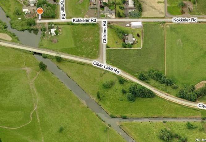
7 ATTACHMENT #1
8 IN THE BOARD OF COUNTY COMMISSIONERS OF LANE COUNTY, OREGON ORDER NO. ( ( ( ( ( In the Matter of Authorizing the Sale of a Parcel of County-Owned Surplus Property Identified as Tax Lots 2000 and 2100 on Lane County Assessor s Map # and WHEREAS, Lane County owns the property located at Kokkeler Road, Eugene; WHEREAS, Earl Cavin has offered to purchase the property for $120,000 and that offer was previously approved through Board Order No ; and WHEREAS, Earl Cavin has also applied for a VA loan and entered into an agreement with Clayton Homes of Albany to install a new manufactured home on the site; and WHEREAS, said lender will not make a loan to Mr. Cavin unless the property and the manufactured home is sold as a unit; and WHEREAS, this can only occur if CMH Homes, Inc. DBA Clayton Homes #613 takes title to the land instead of Earl Cavin; and WHEREAS, ORS (2) allows the sale of property in the manner provided in ORS Chapter 271 if the real estate was not acquired by foreclosure for nonpayment of real property taxes and if the Board determines that the public interest will be furthered; and NOW THEREFORE, IT IS HEREBY ORDERED that pursuant to ORS (2), the real property be sold to CMH Homes, Inc., DBA Clayton Homes #613 for $120,000, that the Bargain and Sale Deed in the form shown on the attached Exhibit A be executed by the Board, and that the proceeds be disbursed as follows: Road Fund ( ) $120,000 IT IS FURTHER ORDERED that this Order shall be entered into the records of the Board of s of Lane County, Oregon. EFFECTIVE DATE: this day of, APPROVED AS TO FORM: Sid Leiken, Chair Board of County s Date: Lane County Office of Legal Counsel
TO AUTHORIZE THE SALE OF SURPLUS COUNTY OWNED REAL PROPERTY FOR $9,000 TO MEHRAN SEPEHRI AND CAROL MILLS, MAP NO.
 Memorandum Date: January 9, 2017 Agenda Date: January 24, 2017 ====================================================================== TO: Board of County Commissioners DEPARTMENT: Public Works PRESENTED
Ill 1111 A i
 lh L S AFTER RECORDING RETURN TO & SEND ALL TAX STATEMENTS TO :. : Tillamook County, 2,, 201 Laurel Avenue,,; r Tillamook, OR 97141 e --- (,.,, Tillamook County, Orego n 10/2512006 02 :03 :34 PM DEED-ORAC
A G E N D A C O V E R M E M O R A N D U M
 A G E N D A C O V E R M E M O R A N D U M Memorandum Date: February 17, 215 Aenda Date: March 3, 215 ====================================================================== TO: Board of County Commissioners
RESOLUTION NO A RESOLUTION ACCEPTING THE FOLLOWING RIGHT-OF-WAY DEDICATION: Pur ose
 RESOLUTION NO. 6538 A RESOLUTION ACCEPTING THE FOLLOWING RIGHT-OF-WAY DEDICATION: Grantor Richard D. Hews and Sharon F. Hews Pur ose A variable -width right-of-way dedication for the north half of the
BILL NO (Emergency Measure) ORDINANCE NO. 5072
 ORDINANCE NO. 5072") BILL NO. 5210 (Emergency Measure) ORDINANCE NO. 5072 AN ORDINANCE AUTHORIZING THE MAYOR TO EXECUTE WITH MICHELSON-HADLEY HEIGHTS DEVELOPMENT, LLC, A CONTRACT AND QUIT CLAIM DEED CONVEYING CERTAIN PROPERTIES
BILL NO. 5210 (Emergency Measure) ORDINANCE NO. 5072 AN ORDINANCE AUTHORIZING THE MAYOR TO EXECUTE WITH MICHELSON-HADLEY HEIGHTS DEVELOPMENT, LLC, A CONTRACT AND QUIT CLAIM DEED CONVEYING CERTAIN PROPERTIES
PIPELINE RIGHT-OF-WAY EASEMENT
 PIPELINE RIGHT-OF-WAY EASEMENT THIS RIGHT-OF-WAY EASEMENT made this day of March, 2014, by the City of Rochester Hills, a municipal corporation in the State of Michigan,, having an address at 1000 Rochester
Council Communication October 20, 2015, Business Meeting
 Council Communication October 20, 2015, Business Meeting Approval of Quitclaim Deeds to Terminate Public Pedestrian Access Easements FROM: Scott A. Fleury, Engineering Services Manager, Public Works, fleurys@ashland.or.us
DRAINAGE AND UTILITY EASEMENT. That Bruce Conrad, a single adult, hereinafter referred to as Grantor for good and
 DRAINAGE AND UTILITY EASEMENT KNOW ALL PERSONS BY THESE PRESENTS: That Bruce Conrad, a single adult, hereinafter referred to as Grantor for good and valuable consideration, the receipt and sufficiency
Sketch & Legal Description of Mitigation Bank and Ingress/Egress Access Easements
 Appendix H: Sketch & Legal Description of Mitigation Bank and Ingress/Egress Access Easements Tippen Bay Wetland Mitigation Bank DeSoto County, Florida Prepared by: September, 2017 Original file
GREENWAY EASEMENT AGREEMENT
 GREENWAY EASEMENT AGREEMENT This greenway access easement is entered into by and between the Laramie County School District Number One ( Grantor ), a corporate body organized under the laws of the State
NON-EXCLUSIVE ROADWAY AND UTILITY EASEMENT DEED AND AGREEMENT
 RETURN TO: STOGSDILL LAW OFFICE, P.C. 505 West Main, Suite 313 Lewistown, Montana 59457 (406) 538-2623 NON-EXCLUSIVE ROADWAY AND UTILITY EASEMENT DEED AND AGREEMENT THIS EASEMENT DEED AND AGREEMENT is
COUNCIL AGENDA MEMO ITEM NO. III - #1
 COUNCIL AGENDA MEMO ITEM NO. III - #1 FROM: Anton Jelinek, Director of Utilities MEETING: October 24, 2017 SUBJECT: PRESENTER: Permanent Utility and Right-of-Way Easement Anton Jelinek Discussion: At the
30.00 $11.00 $17.00 $10.00 $20.00 $
 RECORDING COVER SHEET (Please Print or Type) This cover sheet was prepared by the person presenting the instrument for recording. The information on this sheet is a reflection of the attached instrument
E WASHINGTON COUNTY OREGON. Andy Back, Planning and Development Services Manager
 Exhibit A E WASHINGTON COUNTY OREGON August 8, 2016 To: From: Subject: Board of Commissioners Andy Back, Planning and Development Services Manager MINOR BOUNDARY CHANGE CASEFILE NOS. 16-029 LRP/BC - ANNEXATION
MINUTES OF A REGULAR PLANNING COMMISSION MEETING HELD, TUESDAY, OCTOBER 11, :30 P.M. ROCKVILLE CITY HALL
 28 MINUTES OF A REGULAR PLANNING COMMISSION MEETING HELD, TUESDAY, OCTOBER 11, 2011 6:30 P.M. ROCKVILLE CITY HALL The meeting was called to order by Chair Toni Honer. Roll call was taken and the following
AGENDA UPDATE ECONOMIC DEVELOPMENT & FINANCE STANDING COMMITTEE MEETING MONDAY, AUGUST 10, 2015 III. COMMITTEE AGENDA
 AGENDA UPDATE ECONOMIC DEVELOPMENT & FINANCE STANDING COMMITTEE MEETING MONDAY, AUGUST 10, 2015 III. COMMITTEE AGENDA REVISED ITEM NO. 4 150217.ORDINANCE: VACATION VILLAGE AREAS 1 AND 2A Synopsis: A revised
LANDSCAPE AND MAINTENANCE EASEMENT. THIS LANDSCAPE AND MAINTENANCE EASEMENT, (hereinafter Easement )
") Prepared by and return to: Parcel ID # LANDSCAPE AND MAINTENANCE EASEMENT THIS LANDSCAPE AND MAINTENANCE EASEMENT, (hereinafter Easement ) is made and entered into this day of, 2009, by and between THIRD
Prepared by and return to: Parcel ID # LANDSCAPE AND MAINTENANCE EASEMENT THIS LANDSCAPE AND MAINTENANCE EASEMENT, (hereinafter Easement ) is made and entered into this day of, 2009, by and between THIRD
Reservations of all oil, gas, mineral, geothermal, and water rights.
 Form A- 158 County of Sandoval WARRANTY DEED Recorp New Mexico Associates Limited Partnership 11, a New Mexico limited Partnership hereinafter referred to as the Grantor, for valuable consideration paid,
The City Council of the City of Sulphur, Louisiana, met in special session at its
 July 12, 2018 The City Council of the City of Sulphur, Louisiana, met in special session at its regular meeting place in the Council Chambers, Sulphur, Louisiana, on July 12, 2018 at 5:00 p.m., after full
REVIEWED BY: Administrator Counsel Program Mgr.: Tiffany Schaufler Board Committee Engineer Other
 Minnehaha Creek Watershed District REQUEST FOR BOARD ACTION MEETING DATE: May 11, 2017 TITLE: Authorization to Grant a Temporary Easement to the City of Minnetrista RESOLUTION NUMBER: 17-034 PREPARED BY:
DEED AND DEDICATION FOR PUBLIC RIGHT OF WAY
 TO : BOARD OF DIRECTORS FROM : GARY PLATT, EXEC. DIRECTOR BUSINESS AND OPERATIONS SUBJECT : CITY OF STANWOOD CONSTRUCTION EASEMENT AND RIGHT-OF-WAY DEDICATION DATE : MARCH 17, 2009 TYPE : ACTION NEEDED
AN ACT. The General Assembly of the Commonwealth of Pennsylvania hereby enacts as follows:
 CONVEYANCES - COMMONWEALTH PROPERTY IN LIGONIER BOROUGH, WEST MORELAND COUNTY; CITY OF CONNELLSVILLE, FAYETTE COUNTY; CITY OF ALLENTOWN, LEHIGH COUNTY; BENSALEM TOWNSHIP, BUCKS COUNTY, AND SUSQUEHANNA
MEMORANDUM. Mayor and City Council. Warren Hutmacher, City Manager. Date: February 11, 2013
 MEMORANDUM To: From: Mayor and City Council Warren Hutmacher, City Manager Date: February 11, 2013 Subject: Approval of an Intergovernmental agreement by and between the City of Dunwoody and DeKalb County
LISA ANDERSON-OGILVIE, AICP DEPUTY COMMUNITY DEVELOPMENT DIRECTOR AND PLANNING ADMINISTRATOR
 FOR MEETING OF: December 12, 2018 CASE NO.: VUL18-01 TO: FROM: HEARINGS OFFICER LISA ANDERSON-OGILVIE, AICP DEPUTY COMMUNITY DEVELOPMENT DIRECTOR AND PLANNING ADMINISTRATOR SUBJECT: VALIDATION OF UNIT
CHAPTER XIX ANNEXATION ARTICLE 1. ANNEXATION
 CHAPTER XIX ANNEXATION ARTICLE 1. ANNEXATION 19.0101 JABORSKY ADDITION: WHEREAS, The City of Belfield pursuant to Section 40-51.2-07 of the North Dakota Century Code has amended having passed a Resolution
INTERGOVERNMENTAL AGREEMENT
 INTERGOVERNMENTAL AGREEMENT This Intergovernmental Agreement (this Agreement) is made and entered into as of December 1, 2010, by and between the VILLAGE OF BIG ROCK, an Illinois municipal corporation
FIFTH AMENDMENT OF DECLARATION OF DEED RESTRICTIONS AND DEDICATIONS FOR PINEHURST ESTATES (A Clatsop County, Oregon Subdivision)
") After Recording Return To: W. Louis Larson 990 Astor Street Astoria, OR 97103 FIFTH AMENDMENT OF DECLARATION OF DEED RESTRICTIONS AND DEDICATIONS FOR PINEHURST ESTATES (A Clatsop County, Oregon Subdivision)
After Recording Return To: W. Louis Larson 990 Astor Street Astoria, OR 97103 FIFTH AMENDMENT OF DECLARATION OF DEED RESTRICTIONS AND DEDICATIONS FOR PINEHURST ESTATES (A Clatsop County, Oregon Subdivision)
1 f,;ce,-,j'i: /1 1.?,-. A FOR TILLAMOOK COUNTY, commissioners, at which time it appears that the construction of
 1 /1 1.?,-. A 1 f,;ce,-,j'i: BEFORE THE BOARD OF COUNTY FOR TLLAMOOK COUNTY, n the Matter of Accepting a ) Deed for Right-of-way widening in ) connection with the Construction ) of a portion of the Blaine
As Introduced. 131st General Assembly Regular Session H. B. No
 131st General Assembly Regular Session H. B. No. 239 2015-2016 Representative Sears A B I L L To amend section 5120.092 and to enact section 5120.80 of the Revised Code to allow the Director of Budget
Northwest Natural Gas Company Application for an Order Authorizing the Sale of Certain Property Located in Albany, Oregon
 SHAWN M. FILIPPI Associate Counsel Tel: 503.220.2435 Fax: 503.220.2584 email: shawn.filippi@nwnatural.com July 11, 2008 VIA ELECTRONIC FILING Public Utility Commission of Oregon 550 Capitol Street NE,
RESOLUTION NO Purpose. NOW, THEREFORE, BE IT RESOLVED by the Albany City Council that it does hereby accept this
 RESOLUTION NO. 6567 A RESOLUTION ACCEPTING THE FOLLOWING EASEMENT: Grantor Purpose Hope Church ( AKA First Assembly of God A 2 foot by 2 foot easement for public sidewalk Albany) and pedestrian crosswalk
In Rem Foreclosure of Tax Liens By Lafayette County For Tax Years
 In Rem Foreclosure of Tax Liens By Lafayette County For Tax Years 2007-2011 Properties owned by Lafayette County, WI Sealed Bid Auction Date: November 13, 2015 Sealed Bid Auction Time: 11:00 a.m. Sealed
CITY OF HIAWATHA, IOWA TOWN VILLAGE CENTER URBAN REVITALIZATION PLAN. for the TOWN VILLAGE CENTER URBAN REVITALIZATION AREA
 CITY OF HIAWATHA, IOWA TOWN VILLAGE CENTER URBAN REVITALIZATION PLAN for the TOWN VILLAGE CENTER URBAN REVITALIZATION AREA 2018 1 INTRODUCTION The Urban Revitalization Act, Chapter 404 of the Code of Iowa,
WATERFORD LANDING COMMUNITY DEVELOPMENT DISTRICT REGULAR MEETING AGENDA
 WATERFORD LANDING COMMUNITY DEVELOPMENT DISTRICT REGULAR MEETING AGENDA January 31, 2019 Waterford Landing Community Development District OFFICE OF THE DISTRICT MANAGER 2300 Glades Road, Suite 410W Boca
BEFORE THE BOARD OF COMMISSIONERS OF LANE COUNTY, OREGON
 BEFORE THE BOARD OF COMMISSIONERS OF LANE COUNTY, OREGON ORDER NO: 18-04-03-04 IN THE MATTER OF AUTHORIZING THE SALE OF COUNTY OWNED REAL PROPERTY FOR $25,500 PURSUANT TO A LAND SALES CONTRACT TO LOIS
CONVEYANCE - COMMONWEALTH PROPERTY IN THE BOROUGH OF EAST STROUDSBURG, MONROE COUNTY Act of Jul. 1, 2016, P.L., No. 65 Cl.
 CONVEYANCE - COMMONWEALTH PROPERTY IN THE BOROUGH OF EAST STROUDSBURG, MONROE COUNTY Act of Jul. 1, 2016, P.L., No. 65 Cl. 85 An Act Authorizing the Department of General Services, with the approval of
GENERAL WARRANTY DEED
 PROJECT. # 89008160 TRACT NO.:10 PARCEL ID NO.:PL199032200000001003 OWNERS NAME: Park Hill School District SITUS ADDRESS:5520 N. Northwood: KANSAS CITY, MISSOURI MAILING ADDRESS:7703 NW Barry Rd. Kansas
RESOLUTION TO ACCEPT DEED OF DEDICATION FOR A RELOCATED UTILITY EASEMENT AS SHOWN ON APPROVED SUBDIVISION PLAN FOR THE LOWER MERION HIGH SCHOOL
 Exhibit D RESOLUTION TO ACCEPT DEED OF DEDICATION FOR A RELOCATED UTILITY EASEMENT AS SHOWN ON APPROVED SUBDIVISION PLAN FOR THE LOWER MERION HIGH SCHOOL WHEREAS, the Board of Commissioners of the Township
EASEMENT AGREEMENT. WHEREAS, Ferguson is the 100% owner of the property described on Exhibit B attached hereto (the Williams Property );
;") EASEMENT AGREEMENT THIS EASEMENT AGREEMENT ( Agreement ) is entered into as of this day of, 2016, by and between CRAIG FERGUSON ( Ferguson ), and MAMIE DAVIS and JERRY MOORE ( Davis & Moore ), whose legal
EASEMENT AGREEMENT THIS EASEMENT AGREEMENT ( Agreement ) is entered into as of this day of, 2016, by and between CRAIG FERGUSON ( Ferguson ), and MAMIE DAVIS and JERRY MOORE ( Davis & Moore ), whose legal
NOW, THEREFORE, BE IT RESOLVED by the Albany City Council that it does hereby accept this easement.
 RESOLUTION NO. 5991 A RESOLUTION ACCEPTING THE FOLLOWING EASEMENT: Grantor Albany Industrial Properties, LLC Purpose A 40 -foot wide easement over a new deep trunk sewer main east of I -5 as part of the
Regular Agenda / Public Hearing for Board of Commissioners meeting January 7, 2015
 Rebecca W. Arnold, Commissioner Sara M. Baker, Commissioner Jim D. Hansen, Commissioner Kent Goldthorpe, Commissioner Paul Woods, Commissioner TO: FROM: ACHD Board of Commissioners & Bruce S. Wong, Director
RESOLUTION NO. A RESOLUTION GRANTING AND ACCEPTING THE FOLLOWING STREET AND UTILITY. purpose
 RESOLUTION NO. 6627 A RESOLUTION GRANTING AND ACCEPTING THE FOLLOWING STREET AND UTILITY RIGHT-OF-WAY DEDICATION: Grantor City of Albany purpose Converting a variable width area of City property into street
ORDINANCE NO AN ORDINANCE To Be Entitled:
 3808 AN ORDINANCE To Be Entitled: AN ORDINANCE OF THE CITY COUNCIL OF THE CITY OF FORT MYERS, FLORIDA, REZONING FROM COMMERCIAL GENERAL TO PLANNED UNIT DEVELOPMENT AND APPROVING THE DEVELOPMENT PLAN FOR
ADMINISTRATIVE HEARING STAFF REPORT Country Club Acres Second Amended Subdivision Amendment PLNSUB E Parkway Avenue December 12, 2013
 ADMINISTRATIVE HEARING STAFF REPORT Country Club Acres Second Amended Subdivision Amendment PLNSUB2013-00925 2167 E Parkway Avenue December 12, 2013 Planning Division Department of Community & Economic
AN ORDINANCE TO REZONE A CERTAIN PARCEL OF LAND IN THE CITY OF MOUNTAIN BROOK, ALABAMA FROM RESIDENCE C DISTRICT TO LOCAL BUSINESS DISTRICT
 ORDINANCE NO. 1904 AN ORDINANCE TO REZONE A CERTAIN PARCEL OF LAND IN THE CITY OF MOUNTAIN BROOK, ALABAMA FROM RESIDENCE C DISTRICT TO LOCAL BUSINESS DISTRICT WHEREAS, after due consideration, the City
BEFORE THE BOARD OF COUNTY COMMISSIONERS OF LANE COUNTY, OREGON
 BEFORE THE BOARD OF COUNTY COMMISSIONERS OF LANE COUNTY, OREGON ORDER NO. 15-11-03-03 IN THE MATTER OF VACATING AN UNNAMED PUBLIC ROAD, LOCATED WITHIN WATT'S ADDITION TO BLUE RIVER CITY, WITHOUT A PUBLIC
LAND SALE CONTRACT Josephine County, Oregon
 LAND SALE CONTRACT Josephine County, Oregon This Agreement is made by and between JOSEPHINE COUNTY, a political subdivision of the State of Oregon, hereinafter called COUNTY, and, hereinafter called PURCHASER.
COUNTY OF CHISAGO, STATE OF MINNESOTA
 OFFICE OF COUNTY AUDITOR-TREASURER COUNTY OF CHISAGO, STATE OF MINNESOTA NOTICE OF EXPIRATION OF REDEMPTION To all persons interested in the lands hereinafter described: You are hereby notified that the
ATTACHMENT B GRANT DEED. This deed is in satisfaction of the Eminent Domain Action Case No. GRANT DEED
 GRANT DEED RECORDING REQUESTED BY AND WHEN RECORDED MAIL TO: County of Orange County Executive Office CEO Real Estate 333 W. Santa Ana Blvd. Bldg. 10 Santa Ana, California 92701 AND MAIL TAX STATEMENTS
COUNTY OF LOS ANGELES
 COUNTY OF LOS ANGELES DEPARTMENT OF PUBLIC WORKS 900 SOUTH FREMONT AVENUE ALHAMBRA, CALIFORNIA 91803-1331 Telephone: (626) 458-5100 JAMES A. NOYES, Director ADDRESS ALL CORRESPONDENCE TO: P.O. BOX 1460
RIGHT OF WAY AND COMMON DRIVEWAY AGREEMENT SUN8 PDC, LLC, c/o DISTRIBUTED SUN, LLC SUBDIVISION DRYDEN, NEW YORK
 RIGHT OF WAY AND COMMON DRIVEWAY AGREEMENT SUN8 PDC, LLC, c/o DISTRIBUTED SUN, LLC SUBDIVISION DRYDEN, NEW YORK THIS RIGHT OF WAY AGREEMENT ( Agreement ) is made this day of, 2017 by SCOTT PINNEY, an individual
NOW, THEREFORE, BE IT RESOLVED by the Albany City Council that it does hereby accept this right -of way - dedication deed.
 RESOLUTION NO. 6031 A RESOLUTION ACCEPTING THE FOLLOWING RIGHT OF WAY DEDICATION DEED: Grantor Purpose The First Church of God, Albany, Oregon, an A 60 -foot wide street right -of way - dedication for
BEFORE THE BOARD OF COUNTY COMMISSIONERS OF LANE COUNTY, OREGON
 BEFORE THE BOARD OF COUNTY COMMISSIONERS OF LANE COUNTY, OREGON ORDER NO: 14-04-22-02 IN THE MATTER OF RELEASING, DEDICATING, AND ACCEPTING PARCEL "A" OF THE PLAT OF LEE VILLA, AS RIGHT OF WAY FOR LARALEE
BEFORE THE BOARD OF COUNTY COMMISSIONERS OF LANE COUNTY, OREGON
 BEFORE THE BOARD OF COUNTY COMMISSIONERS OF LANE COUNTY, OREGON ORDER NO: 15-07-14-08 IN THE MATTER OF RELEASING, DEDICATING AND ACCEPTING LOT "D" OF THE PLAT OF HOLL YVIEW ESTATES, AS RIGHT OF WAY FOR
Village of Mantua, Ohio ORDINANCE
 AN ORDINANCE AUTHORIZING THE MAYOR TO EXECUTE A LEASE / OPTION TO PURCHASE AGREEMENT WITH THE PORTAGE PARK DISTRICT FOR THE HEADWATERS TRAIL WEST OF STATE ROUTE 44, AND DECLARING AN EMERGENCY. WHEREAS,
CITY OF OCALA CITY COUNCIL REPORT Council Meeting Date: 06/06/17
 CITY OF OCALA CITY COUNCIL REPORT Council Meeting Date: 06/06/17 Subject: Large Scale Land Use Map Amendment Submitted By: David Boston Department: Growth Management STAFF RECOMMENDATION (Motion Ready):
CONSENT ACTION BY THE BOARD OF DIRECTORS OF VENETO IN MIRAMAR CONDOMINIUM ASSOCIATION, INC.
 CONSENT ACTION BY THE BOARD OF DIRECTORS OF VENETO IN MIRAMAR CONDOMINIUM ASSOCIATION, INC. The undersigned, being all of the members of the Board of Directors of Veneto in Miramar Condominium Association,
Easement under Section 65 of The Water Security Agency Act
 Easement under Section 65 of The Water Security Agency Act THIS AGREEMENT MADE BETWEEN: OF hereinafter called the Grantor, - and - Insert Full name of Grantor Insert Address of Grantor OF hereinafter called
RATE AND METHOD OF APPORTIONMENT FOR COMMUNITY FACILITIES DISTRICT NO. 4 - MAINTENANCE OF THE CITY OF MORENO VALLEY
 CFD No. 4 Maintenance Page 1 RATE AND METHOD OF APPORTIONMENT FOR COMMUNITY FACILITIES DISTRICT NO. 4 - MAINTENANCE OF THE CITY OF MORENO VALLEY A Special Tax as hereinafter defined shall be levied on
Cross Reference: Instrument No. A State Parcel No Parcel: TEMPORARY CONSTRUCTION EASEMENT AGREEMENT
 Cross Reference: Instrument No. A199500066899 Project: 92TU000128 State Parcel No. 49-07-18-107-004.000-801 Parcel: 8033304 Date: Version: TEMPORARY CONSTRUCTION EASEMENT AGREEMENT THIS TEMPORARY CONSTRUCTION
UNITED STATES DEPARTMENT OF THE INTERIOR BUREAU OF INDIAN AFFAIRS CHICKASAW AGENCY
 Exhibit 15: State of Oklahoma, Choctaw Nation of Oklahoma, Chickasaw Nation, City of Oklahoma City Water Settlement File No. Allottee: Parcel No. AFTER RECORDING RETURN TO: City of Oklahoma City Office
Regular Agenda / Public Hearing for Board of Commissioners meeting September 24, 2014
 John S. Franden, President Mitchell A. Jaurena, Vice President Rebecca W. Arnold, Commissioner Sara M. Baker, Commissioner Jim D. Hansen, Commissioner TO: FROM: ACHD Board of Commissioners & Bruce S. Wong,
MEMORANDUM. Michael Smith, Director of Public Works. Discussion of Temporary Aerial Easement for KDC
 MEMORANDUM To: From: Mayor and City Council Michael Smith, Director of Public Works Date: August 11, 2014 Subject: Discussion of Temporary Aerial Easement for KDC ITEM DESCRIPTION Discussion of an aerial
PLANNING COMMISSION REPORT Non-Public Hearing Item
 PC Staff Report 09/21/2015 Item No. 2B - 1 PLANNING COMMISSION REPORT Non-Public Hearing Item PC Staff Report 09/212015 ITEM NO. 2B: FINAL PLAT FOR MORGAN ADDITION; 800 MONTEREY WAY (MKM) : Consider a
EASEMENT DEED. 2) Thence N 60º12 36 W through said Parcel 1 a distance of Two Hundred Ninety- Five and 97/100 (295.97) feet to a point;
 Thence N 60º12 36 W through said Parcel 1 a distance of Two Hundred Ninety- Five and 97/100 (295.97) feet to a point;") EASEMENT DEED TALL TREES CONSTRUCTION CORP., a Maine corporation having a mailing address of 30 Preservation Drive, Falmouth, Maine 04105 (the "Grantor") for consideration paid, grants to the TOWN OF FALMOUTH,
EASEMENT DEED TALL TREES CONSTRUCTION CORP., a Maine corporation having a mailing address of 30 Preservation Drive, Falmouth, Maine 04105 (the "Grantor") for consideration paid, grants to the TOWN OF FALMOUTH,
-ii~ ADAMS COUNTY. &,.ee8.& PUBLIC HEARING AGENDA ITEM
 -ii~ ADAMS COUNTY &,.ee8.& PUBLIC HEARING AGENDA ITEM DATE: January 6,2015 SUBJECT: Easement grant to Molson Coors FROM: Jeffery A. Maxwell, P.E., PTOE, Transportation Director~ AGENCYIDEPARTMENT: Transportation
AMENDMENT TO POWER PURCHASE AGREEMENT
 AMENDMENT TO POWER PURCHASE AGREEMENT This Amendment Power Purchase and Agreement ( Amendment ) is entered into as of, 2012, by and between, (hereinafter RMW ) a Nevada limited liability company, and The
QUITCLAIM DEED CR 202 THE STATE OF TEXAS KNOW ALL MEN BY THESE PRESENTS: COUNTY OF WILLIAMSON
 QUITCLAIM DEED CR 202 THE STATE OF TEXAS KNOW ALL MEN BY THESE PRESENTS: COUNTY OF WILLIAMSON That WILLIAMSON COUNTY, TEXAS, hereinafter referred to as Grantor, whether one or more, for and in consideration
Exhibit A: REAL ESTATE TRANSFER AGREEMENT
 Exhibit A: REAL ESTATE TRANSFER AGREEMENT This agreement is made between the City of Urbana, Illinois, a municipal corporation of the State of Illinois (the Seller ), and Homestead Corporation of Champaign-Urbana,
PROPERTY EXCHANGE & CONVEYANCE AGREEMENT RECITALS
 PROPERTY EXCHANGE & CONVEYANCE AGREEMENT This Property Exchange and Conveyance Agreement ( Agreement ) is entered into as of the date of execution by and between Laramie Church of Christ, Inc., a Wyoming
NOW, THEREFORE, BE IT RESOLVED by the Albany City Council that it does hereby accept this
 RESOLUTON NO. 6614 A RESOLUTON ACCEPTNG THE FOLLOWNG EASEMENT: Grantor Purpose Koos Family, LLC A 10 foot by 23. 8 foot easement for public storm drainage as part of the Somerset Subdivision development.
OFFICIAL SUMMARY OF AN ORDINANCE TO CONVEY CERTAIN RAMSEY COUNTY PARK AND OPEN SPACE LANDS TO THE CITY OF MAPLEWOOD.
 OFFICIAL SUMMARY OF AN ORDINANCE TO CONVEY CERTAIN RAMSEY COUNTY PARK AND OPEN SPACE LANDS TO THE CITY OF MAPLEWOOD. This ordinance authorizes the conveyance of park and open space land owned by Ramsey
NORTH CAROLINA DEED OF TRUST
 NORTH CAROLINA DEED OF TRUST SATISFACTION: The debt secured by the within Deed of Trust together with the note(s) secured thereby has been satisfied in full. This the day of, 20 Signed: Parcel Identifier
TOWN OF LYONS, COLORADO ORDINANCE NO. 1017
 TOWN OF LYONS, COLORADO ORDINANCE NO. 1017 AN ORDINANCE OF THE BOARD OF TRUSTEES OF THE TOWN OF LYONS ANNEXING TO THE TOWN OF LYONS CERTAIN REAL PROPERTY OWNED BY THE TOWN OF LYONS WHEREAS, the Town of
Board Summary Report
 BoCC Consent Agenda: July 22, 2014 Consent Agenda Item#: Board Summary Report Date: July 8, 2014 To: Through: Through: From: Arapahoe County Board of County Commissioners David M. Schmit, PE, Director
;;o. c I"'\ z. :enc. ml>~ ("\ Vt. ,.. :c CORPORATION WARRANTY DEED WITH RESTRICTIONS
 -------- ' j 2 - (I; }> (.' 0 W "tjo v :.; ' ;;o -n c I"'\ z :enc l> ("\ Vt,.. :c ("\ () ::c );> Ito V'I -n? :c 1' '.:'\...,, ' \ "' Q - ( co I. > :v:.. ', (., i"),, r1 (.,.) l'i y ;. t.,._; "",.. 3 U:.J
City Council Information Form
 City Council Information Form DATE: 08/13/2014 ASSIGNED STAFF: Robert McKay DEPARTMENT: Planning&Development TYPE OF FORM: Ordinances Form No.: 4490 APPROVALS: None ISSUE/REQUEST: AN ORDINANCE VACATING
SOUTH DAKOTA BOARD OF REGENTS. Committee on Budget and Finance ******************************************************************************
 SOUTH DAKOTA BOARD OF REGENTS Committee on Budget and Finance AGENDA ITEM: III O DATE: December 12-13, 2012 ****************************************************************************** SUBJECT: Resolution
EASEMENT AGREEMENT. WHEREAS, Hall Brothers owns certain real property located in Weber County, Utah ( Hall Brothers Property );
;") When Recorded Return to: Parcel No. EASEMENT AGREEMENT THIS EASEMENT AGREEMENT ( Agreement ) is entered into this day of, 2016 by and between VALLEY DREAMS PROPERTIES, LLC, a Utah limited liability company
When Recorded Return to: Parcel No. EASEMENT AGREEMENT THIS EASEMENT AGREEMENT ( Agreement ) is entered into this day of, 2016 by and between VALLEY DREAMS PROPERTIES, LLC, a Utah limited liability company
DISTRICT. Huntington Beach. FIM 40-40C-3 APN and
 RECORDING REQUESTED BY W HEN RECORDED MAIL TO SOUTHERN CALIFORNIA EDISON COMPANY 2131 WALNUT GROVE AVENUE 2 ND FLOOR GO3 ROSEMEAD, CA 91770 Attn: Title and Real Estate Services SPACE ABOVE THIS LINE FOR
COUNTY OF LOS ANGELES
 JAMES A. NOYES, Director COUNTY OF LOS ANGELES DEPARTMENT OF PUBLIC WORKS 900 SOUTH FREMONT AVENUE ALHAMBRA, CALIFORNIA 91803-1331 Telephone: (626) 458-5100 ADDRESS ALL CORRESPONDENCE TO: P.O. BOX 1460
Earnest Money Agreement
 DATE: March 23, 2016 Earnest Money Agreement SELLER: MULTNOMAH COUNTY, OREGON by and through its Tax Title Program, 501 S.E. Hawthorne Blvd., Suite 200, Portland, Oregon, 97214-3577, ( County or Seller
CITY OF PORT ST LUCIE
 CITY OF PORT ST LUCIE COUNCIL AGENDA MEMORANDUM 7W Agenda Item #: Meeting Date: 4/24/17 TO: Mayor and City uncil VIA: Russ Blackburn, y Manager FROM: O. Reginald Osenton, City Attorney P'(- Agenda Item:
CHAPTER 2 RELATED DOCUMENTS AND FORMS
 CHAPTER 2 RELATED DOCUMENTS AND FORMS TABLE OF CONTENTS CHAPTER 2 RELATED DOCUMENTS AND FORMS Resolution R00- Establishing Public Improvement Design Standards Page 1 Current Plans Review & Construction
COUNCIL ACTION FORM Meeting Date: September 13, 2012 Staff Contact: John Sullivan, Public Works Director
 COUNCIL ACTION FORM Meeting Date: September 13, 2012 Staff Contact: John Sullivan, Public Works Director Agenda Item: Consider vacation of a Landscape Easement granted to the City of Westwood for the construction
AGREEMENT TO MORTGAGE LEASEHOLD ESTATE
 AGREEMENT TO MORTGAGE LEASEHOLD ESTATE THIS AGREEMENT is made and entered into as of the day of, 20, by and among TAN-TAR-A ESTATES L.L.C., a Missouri limited liability company, GRANTOR (hereinafter referred
A G E N D A C O V E R M E M O R A N D U M
 A G E N D A C O V E R M E M O R A N D U M Memorandum Date: August 8, 2016 Agenda Date: August 23, 2016 ====================================================================== TO: Board of County Commissioners
PLANNING SERVICES MEMORANDUM
 PLANNING SERVICES MEMORANDUM March 13, 2017 TO: FROM: SUBJECT: City Council Brian Schweigl, Associate Planner Consideration and action on final Certified Survey Map (CSM) 17002-C, City of Janesville, 2
Community Development Department Council Chambers, 7:30 PM, December 1, 2016
 STAFF REPORT 2016-35P: Subdivision Community Development Department Council Chambers, 7:30 PM, December 1, 2016 To: From: Re: Paul Luke, Chairman, Skokie Plan Commission Mike Voitik, Planning Technician
APPLICATION TO REGISTER NOTICE OF AN AGREEMENT THE LAND TITLES ACT SECTION 74
 26 th May 1981 Campeau - City of Kanata 40% Open Space Agreement APPLICATION TO REGISTER NOTICE OF AN AGREEMENT THE LAND TITLES ACT SECTION 74 TO: THE LAND REGISTRAR FOR THE LAND TITLES DIVISION OF OTTAWA-CARLETON
THE BOARD OF SUPERWSORS OF THE COUNTY OF STANISLAUS ACTION AGENDA SUMMARY. DEPT: Publ~c Works & BOARD AGENDA # *C-1 May 1,2007
 THE BOARD OF SUPERWSORS OF THE COUNTY OF STANISLAUS ACTION AGENDA SUMMARY DEPT: Publ~c Works & BOARD AGENDA # *C-1 May 1,2007 Urgent Routine AGENDA DATE CEO Concurs with Recommendation YES NO 415 Vote
CITY OF PAPILLION MAYOR AND CITY COUNCIL REPORT MAY 16, 2018 AGENDA
 CITY OF PAPILLION MAYOR AND CITY COUNCIL REPORT MAY 16, 2018 AGENDA Subject: Type: Submitted By: A request to vacate the Final Plat for Prairie Queen First Subdivision, a subdivision legally described
PLANNING DIRECTOR. Approved by the Planning Director on this day of, A.D. 20. day of, A.D. 20. Approved by the Fire Chief on this
 Located in a portion of the West Half of Section 19, Township 5 South, Range 1 East, Salt Lake Base and Meridian. SURVEYOR'S CERTIFICATE I, the undersigned surveyor, do hereby certify that I am a registered
NON-EXCLUSIVE TRAIL AND UTILITY EASEMENT
 After recording return to: Public Works Department City of Ellensburg 501 N Anderson St Ellensburg, WA 98926 DOCUMENT TITLE: GRANTOR: GRANTEE: TRAIL AND UTILITY EASEMENT Central Washington University City
AITKIN COUNTY BOARD August 9, 2016
 The Aitkin County Board of Commissioners met this 9 th day of August, 2016 at 9:03 a.m. with the following members present: Board Chair J. Mark Wedel, Commissioners Don Niemi, Brian Napstad, and Anne Marcotte.
ARLINGTON COUNTY, VIRGINIA
 ARLINGTON COUNTY, VIRGINIA County Board Agenda Item Meeting of January 26, 2013 DATE: January 8, 2013 SUBJECT: Amend and Restate the Deed of Easement and Declaration of Restrictive Covenants for to permit
19.12 CLUSTER RESIDENTIAL DISTRICT
 Chapter 19.12 CLUSTER RESIDENTIAL DISTRICT (Adopted 12/22/2003; Ordinance #0061970). Amended 7/3/17, Ordinance #079100. Section 19.12.010 - Declaration of Intent. The Cluster Residential District provides
STAFF REPORT. DATE: November 29, 2012
 STAFF REPORT DATE: November 29, 2012 TO: FROM: SUBJECT: The Honorable Mayor and City Council John Penrod, City Attorney CONSIDERATION OF APPROVING A REAL ESTATE EXCHANGE AGREEMENT BETWEEN THE CITY AND
BOARD OF WATER AND SEWER COMMISSIONERS OF THE CITY OF MOBILE. Appraisal Information Done on the Property:
 BOARD OF WATER AND SEWER COMMISSIONERS OF THE CITY OF MOBILE DISCLOSURE OF INFORMATION ON PURCHASE OF REAL PROPERTY PURSUANT TO ALABAMA ACT #2014-133 Appraisal Information Done on the Property: Was fonnal
Agenda Item C. Village Manager s Office Review _CLP_ Tammie Grossman, Director of Community and Economic Development
 Date January 21, 2014 Agenda Item C Submitted By Village Manager s Office Review _CLP_ Tammie Grossman, Director of Community and Economic Development Agenda Item Title A Resolution Authorizing Subordination