VILLAGE OF MCFARLAND, WISCONSIN District Boundary and Project Plan
|
|
|
- Philippa Wilkinson
- 6 years ago
- Views:
Transcription
1 A Planning Document For VILLAGE OF MCFARLAND, WISCONSIN District Boundary and Project Plan Redevelopment District No. 2 CDA Work Session January 6, 2010
2 Table of Contents Introduction... 1 Map 1: Redevelopment Area #2 Boundary... 5 Redevelopment Objectives... 6 Consistency with Local Plans... 7 Existing Conditions... 7 Map 2: Existing Land Uses... 9 Table 1: Parcel Use Map 3 : Existing Zoning Redevelopment Area Parcels Map 4: Potential Redevelopment Areas Downtown Opportunity Areas & Key Sites Proposed Uses of the Area Standards of Population Density, Land Coverage and Building Intensity after Development Map 5: Proposed Land Uses Priority Redevelopment Sites: Redevelopment Objectives and Concept Plans Table 2: 2009 Parcel and Valuation Listing Proposed Changes in Zoning, Building Codes, Ordinances, and Maps Proposed Site Improvements and Utilities Project Financing Performance Standards Plan Amendments Relocation of Displaced Persons and Businesses Land Disposition Termination Appendix A. Blight Determination Map 6: Blight Determination Parcels Table 3: Blight Determination CDA Work Session i January 6, 2010
3 Introduction The Village of McFarland has been actively engaged in the process of guiding the growth of the Village in an orderly fashion for 30 years through the use of tax increment financing, comprehensive and neighborhood master plans and careful implementation of sound planning and engineering. Through the creation of four TIF Districts, the Village has been able undertake and/or accomplish the goals and objectives identified in each project plan. Over $100,000,000 of new value within the corporate limits has been built as a result of the TIDs enabling the Village to possess a financing vehicle to encourage new and redevelopment. Not only has the Village grown in valuation but it has also grown in an orderly fashion with the highest and best land uses appropriately located within the Village. This comprehensive approach to planning and development has greatly benefitted Village of McFarland residents and business owners. This Village attitude of orderly growth has also allowed McFarland to capture new businesses that provide living wage and high quality jobs. High quality residential growth is also another benefit enjoyed by the Village of McFarland and its residents. This orderly growth is directly associated with the comprehensive approach that the Village has maintained through these past three decades. In an effort to continue the quality of development within the Village of McFarland, Village elected and appointed officials and staff, with consultants, are moving forward with the long-range planning and implementation of two areas within the Village limits. The first area is described in the TID #3 and Redevelopment District #1 project plans. This area encompasses the gateway to the community from the north on the Hwy 51 corridor. This is a key area of the Village as Hwy 51 is a major transportation corridor and directly links the Village to City of Madison metropolitan area, the I-90/94 transportation corridor and all communities to the south along Hwy 51. This area will be designated as Redevelopment District #1 and will duplicate the boundaries of TID #3 and has its own TID and Redevelopment Project Plans. The second area in the Village and the subject of this Redevelopment District Project Plan is the properties located within TID #4. This area encompasses the historic Downtown and properties to the west along Farwell St. This area will be designated as Redevelopment District #2. The project plan for Redevelopment District #2 will complement both TID #4 goals and objectives and the Downtown Strategic Market Analysis and Opportunities Assessment. The properties located within Redevelopment District #2 are known as the historic Downtown with some infill development along Farwell Street that developed due to traffic connecting the Downtown and Hwy 51. As stated in the TID #4 project plan, the Village has seen a small but consequential exodus of businesses out of the historic Downtown area out to the Hwy 51 corridor. In the retail world, new always seems to be better than older and the Village has experienced this same CDA Work Session 1 January 6, 2010
4 trend. Consequently, there is significant vacancy in the historic Downtown which has created blighted conditions. Loss of key businesses (McFarland State Bank) and typical Downtown uses (pharmacy, more restaurants, doctors and veterinarian and other service-oriented offices, etc.) has lessened flow into this area. However, in contrast to the private sector moving out of the Downtown, the Village has made significant investment in the Downtown to offset most loss of business. Expansion of the Village Hall and a recently built Library creating a Civic Campus has greatly enhanced the Downtown and created a regular destination use for residents and visitors. This public reinvestment in the Downtown area has significantly kept the vitality of the area intact although retail action has suffered. TID #4 was created as a blighted Tax Increment Financing District. A formal blight determination was made and incorporated into the project plan and used as the basis for the creation of TID #4. The same blight determination is attached to this Redevelopment District Project Plan. While blighted conditions vary from even week to week, the general conditions found in the 2008 blight determination are still appropriate. No changes have been made to this determination as found at the end of the project plan. One purpose of the is to provide the Village with a vehicle to allow the Community Development Authority to participate in redevelopment projects and also to use Lease Revenue Bonds for financing the infrastructure in TID #4. As stated above, the Redevelopment District boundary is limited to the current TID #4 boundary. The Village may choose to expand the project area in the future. Potential expansion could include properties located west of the shopping center as identified in the Downtown Strategic Market Analysis and Opportunities Assessment. There is an excellent opportunity for redevelopment of properties on both sides of Farwell beginning at Hwy 51 and going east towards the High School and McFarland Center. This area contains a mix of uses and there is potential for redevelopment and rehabilitation of existing uses. This area, at this time, is outside the boundary of Redevelopment District #2 but could be included later. should be used in conjunction with the TID #4 Project Plan. While TID #4 is the financial enabling tool, the TID #4 Project Plan is also the planning document from which to undertake public improvement projects and redevelopment direction for implementation with Redevelopment District #2 Project Plan. The other critical document that the Village should use in planning this area is the Downtown Strategic Market Analysis and Opportunities Assessment as well as implementation strategies based on these documents. CDA Work Session 2 January 6, 2010
5 Statutory Authority This plan has been prepared and adopted under the provisions of , Wis. Stats. Redevelopment Area The boundary of the redevelopment area is shown on Map One. It is further described as follows: METES & BOUNDS DESCRIPTION Commencing at the southwest corner of Lot 4 if CSM 8478, thence north to the northwest corner of said lot, thence east along said lot line to the south line of Taylor Road, thence southeast to the east corner of Lot 4, CSM 8478, thence westerly to the northeast corner of Lot 2, CSM 2332, thence south to the north line of Farwell Street, thence easterly to the southeast corner of Lot 1, CSM 2332, thence northeasterly along the west line of Taylor Road to the east corner of Lot 1, CSM 2332, thence northeasterly to the southeast corner of Lot 1, CSM 2024, Thence northeasterly to the northeast corner of Lot 1, CSM 2024, thence northeasterly along the west line of Wisconsin Street feet, thence east to the east line of Wisconsin Street, thence southeasterly along the north line of Long Street to the southwest corner of Lot 4, Block 25 of the Assessor s Plat, thence north to the southwest corner of Lot 4, Block 20 of the Assessor s Plat, thence east to the southwest corner of Lot 4, Block 22 of the Assessor s Plat, thence south to the northwest corner of Lot 3, Block 23 of the Assessor s Plat, thence east to the northeast corner of said lot, thence south to the northeast corner of Lot 1, Block 27 of the Assessor s Plat, thence west to the northwest corner of Lot 7, Block 26 of the Assessor s Plat, thence south 33 feet, thence west to the southeast corner of Lot 6, Block 25 of the Assessor s Plat, thence southwest to the northeast corner of Lot 1, Block 30 of the Assessor s Plat, thence northwesterly 92 feet along the south line of Long Street, thence southwesterly 165 feet to the north line of the railroad right-ofway, thence southeast to the southeast corner of Lot 1, Block 30 of the Assessor s Plat, thence northeast to the northeast corner of Lot 1, Block 30 of the Assessor s Plat, thence southeast to the northwest corner of Lot 6, Block 29 of the Assessor s Plat, thence northeast to the southwest corner of Lot 6, Block 26 of the Assessor s Plat, thence southeast along the north line of Long Street to the southeast corner of Lot 6, Block 27 of the Assessor s Plat, thence south to the south line of Creamery Road, thence westerly along said line to the east line of Johnson Street, thence southwesterly along said line to a point southeast of the northeast corner of Lot 7, Block 1 of Johnson s Addition, thence westerly along the north line of Lot 7, Block 1 of Johnson s Addition to the northwest corner of said lot, thence southwest to the southwest corner of Outlot 134 of the Assessor s Plat, thence northwest to the northwest corner of said lot, thence westerly to the east corner of Lot 2, Block 39 of CDA Work Session 3 January 6, 2010
6 the Original Plat, thence North 56 West feet, thence South 23 West 66 feet, thence North 53 West 36.3 feet, thence west to the southwest corner of Lot 5, Block 39 of the Original plat, thence west to the west line of Lake Street, thence north to the northeast corner of Lot 2, Block 41 of the Original plat, thence west to the northwest corner of said lot, thence north to the northeast corner of Lot 1, CSM 812, thence west to the northwest corner of said lot, thence north to the south line of Farwell Street, thence west along said line to the northwest corner of Lot 1, Block 48 of the Original Plat, thence north to the Point of Beginning. CDA Work Session 4 January 6, 2010
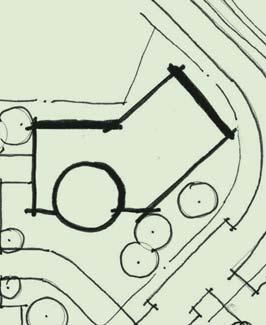
7 Redevelopment District #2 MAP 1: Redevelopment District Boundary DRAFT Railroad Railroad Railroad Railroad NORTH Created: VANDEWALLE & ASSOCIATES INC. 2009
8 Redevelopment Objectives The objectives of this redevelopment plan are to provide direction in the following areas which include, but are not limited to: (1) types and mix of land uses; (2) density of land uses; (3) removing blight as identified in Table 3: Blight Determination; (4) location and types of businesses appropriate to individual development areas; (5) expansion of public uses (parks and parking) and its impact on existing neighborhoods; (6) impact of new and redevelopment upon existing neighborhoods; and (7) quality of materials and level of landscaping in types of land uses. As stated in the Downtown Strategic Market Analysis and Opportunities Assessment and condensed here, the primary goals and redevelopment objectives include, but are not limited to: 1. Encourage and aggressively recruit niche markets for the Downtown core area that primarily cater to the local population. These markets could include retail, restaurant/food and personal services. 2. Enhance marketability of the Downtown core through improvements in wayfinding signage, coordinated Downtown marketing, create a façade improvement program and encourage more activities and improvements in Arnold Larson Park. 3. Redevelop the McFarland Plaza Shopping Center into a highly dense, mixed use development that will cater to all ages and types of users. Uses and assets that should be recruited to this site include senior center, educational facility or recreation center all community uses that service the Village, complement the activities at the High School and encourage more visitors and users of the Downtown. Other uses needed in this comprehensive redevelopment site are retail and housing that could serve all socioeconomic classes and needs of area residents. Senior housing has been identified as a needed commodity within the Village. Location of a senior housing development on this site would enhance Downtown businesses and be readily accessible to Hwy 51 businesses. 4. Consider parking and wayfinding enhancements in the McFarland Plaza Shopping Center while contemplating redevelopment potentials to ease parking demands from the High School and encourage more retail users to locate in this area. The other recommendations contained in the Downtown Strategic Market Analysis and Opportunities Assessment pertain to the Farwell Street Community Gateway Corridor which abuts the Redevelopment District boundary but is not included. As mentioned above, a logical amendment to the boundary of Redevelopment District #2 would be to include these properties at a later date when redevelopment opportunities and demand arise. In summary, Redevelopment Objectives include blight elimination through higher density mixed use projects, filling of empty retail spaces in the Downtown, CDA Work Session 6 January 6, 2010
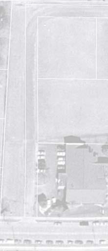
9 encouraging residential redevelopment to help support new and existing business and appropriate expansion of public parks and parking. All of these Redevelopment Objectives, if met, will help alleviate the blighted conditions which currently exist and which the Village is preparing to address through creation of and implementation of the TID #4 Project Plan. Consistency with Local Plans This redevelopment plan is consistent with the recommendations contained in the Village of McFarland Comprehensive Plan. It is also consistent with the Tax Increment Finance District #4 Project Plan and the Downtown Strategic Market Analysis and Opportunities Assessment. These plans may be amended from time to time. This Redevelopment Plan is intended to be consistent with any changes or modifications in the Village s plans as amended and adopted. These documents are available for inspection during normal business hours. Contact Village of McFarland Village Clerk to review the above documents at Village Hall. Existing Conditions Existing Land Use and Zoning Existing land use in the Redevelopment District is depicted on Map Two and Table One. Existing zoning in the Redevelopment District is depicted on Map Three. Existing Conditions The existing conditions within the proposed boundary for Redevelopment District No. 1 are notated on Table 3: Blight Determination. Downtown The Downtown area contains historic retail buildings, some of which are vacant. There is a mix of business and residential in the northern portion of the Downtown area as well as strictly residential. The Civic Campus, while not part of the District, immediately abuts and is in the center of the Downtown. A lumber yard completes the businesses in the Downtown. CDA Work Session 7 January 6, 2010
10 McFarland Plaza Shopping Center This is the other main area of the Redevelopment District. It contains the UW Health Clinic, Associated Bank, the shopping center and the partially vacant former Library. Park and open space and several single family houses connect the Downtown and the Shopping Center area. The redevelopment area currently has the following zoning: 1. Single Family Residential 2. Single and Two Family Residential 3. Central Commercial 4. General Commercial 5. Conservancy CDA Work Session 8 January 6, 2010


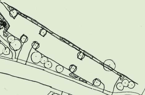
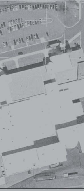
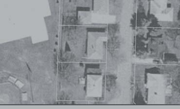
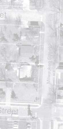
11 Redevelopment District No. 2 Village of McFarland Redevelopment District #2 MAP 2: Existing Land Uses DRAFT Spartan Dr Farwell St 1 Commercial Taylor Rd Railroad Residential Residential Wisconsin St Commercial 14 Railroad 15 Park & Open Space 16 EX Residential Park & Open Space Bashford St Hough St Anthony St Milwaukee St Railroad Railroad Residential Lumber Yard Exchange St Sure Ave Commercial LEGEND Residential Commercial NORTH Created: /8/2009 VANDEWALLE & ASSOCIATES INC Lumber Yard Parks & Open Space
12 VILLAGE OF MCFARLAND REDEVELOPMENT DISTRICT NO. 2 TABLE 1: PARCEL USE Map # Parcel # Property Owner Property Address Class MCFARLAND CENTRE ASSOCIATES LLC 5120 FARWELL ST Comm MCFARLAND, VILLAGE OF Exempt MCFARLAND, VILLAGE OF 5114 FARWELL ST Exempt MCFARLAND CENTRE ASSOCIATES LLC Comm UNIV OF WIS MEDICAL FOUNDATION INC 5020 FARWELL ST Comm MCFARLAND CENTRE ASSOCIATES LLC 5220 FARWELL ST Comm ROLAND H LICHTENBERG 5203 FARWELL ST Res MARILYN PETERS 6002 LAKE ST Res PAUL T PETERS 6003 LAKE ST Res PAUL T PETERS Res PAUL T PETERS Res MCFARLAND, VILLAGE OF 6002 EXCHANGE ST Exempt EDWARD L MEIER 5303 LONG ST Res JOSEPH R HARRINGTON 5305 LONG ST Res PEGGY L CUMMINGS 5311 LONG ST Res MACO MANAGEMENT CO INC 5315 LONG ST Comm JOSEPH R HARRINGTON 5802 MAIN ST Comm GENERAL TELEPHONE CO 5806 MAIN ST Exempt THOMAS H GUNDERSON JR 5810 MAIN ST Res MCFARLAND HISTORICAL SOCIETY 5814 MAIN ST Exempt GORDON C LOFGREN 5902 MAIN ST Comm DAPHNE H SCHNEIDER 5906 MAIN ST Comm PHILIP R OLSON 5910 MAIN ST Comm CRYSTAL C H LOKKEN 5803 MAIN ST Res SHERRY L MARTIN 5802 MILWAUKEE ST Res MARY V LARSON 5807 MAIN ST Comm JARED TORBLEAU 5806 MILWAUKEE ST Res DALE S BORCHARDT 5811 MAIN ST Res ROBERT KALHAGEN 5810 MILWAUKEE ST Res DALE S BORCHARDT 5813 MAIN ST Comm DALE S BORCHARDT 5819 MAIN ST Comm DALE S BORCHARDT 5404 ANTHONY ST Comm ICON REAL ESTATE GROUP LLC 5408 ANTHONY ST Res JEFFREY D BAUMGARTEN 5813 MILWAUKEE ST Res SCOTT WARNE 5817 MILWAUKEE ST Res MICHAEL J CRAPP 5915 EXCHANGE ST Comm STEVEN G WASHA 5923 EXCHANGE ST Comm MICHAEL J CRAPP 5915 EXCHANGE ST Comm STEVEN G WASHA Comm MICHAEL J CRAPP 5915 EXCHANGE ST Comm STEVEN G WASHA Comm CENTRAL WAUBESA LUMBER SUPPLY INC Comm CENTRAL WAUBESA LUMBER SUPPLY COMPANY Comm CHASE LUMBER & FUEL CO INC 5417 LONG ST Comm CHASE LUMBER & FUEL CO INC Comm CENTRAL WAUBESA LUMBER SUPPLY INC 5417 LONG ST Comm CENTRAL WAUBESA LUMBER SUPPLY INC Comm CENTRAL WAUBESA LUMBER SUPPLY INC Comm CENTRAL WAUBESA LUMBER SUPPLY INC Comm MCFARLAND, VILLAGE OF 6001 EXCHANGE ST Exempt WI DOT 6001 EXCHANGE ST Exempt MICHAEL J ZIRKEL 5410 BASHFORD ST Comm
13 VILLAGE OF MCFARLAND REDEVELOPMENT DISTRICT NO. 2 TABLE 1: PARCEL USE Map # Parcel # Property Owner Property Address Class ROY G HOENECKE 6005 EXCHANGE ST Res MCFARLAND, VILLAGE OF Exempt ROY G HOENECKE 6003 EXCHANGE ST Res THELMA M ALLEN 5403 BASHFORD ST Res GARRY T MOORE 5407 BASHFORD ST Comm JOHN J GRELL 5411 BASHFORD ST Comm


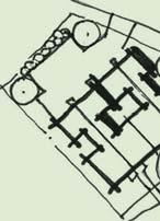
14 Redevelopment District #2 MAP 3: Zoning DRAFT Railroad Central Commercial Single Family Residential General Commercial Railroad Central Commercial Conservancy Single Family Residential Single Family Residential Central Commercial Railroad Railroad Single & Two-Family Residence LEGEND Single Family Residential Single & Two-Family Residence Central Commercial NORTH Created: VANDEWALLE & ASSOCIATES INC General Commercial Conservancy
15 Redevelopment Area Parcels Map Four identifies the Potential Redevelopment Areas. Redevelopment Areas are interspersed with already improved parcels containing businesses that are consistent with the goals and objectives of the overall district. Vacant land coexists with partially improved lots. The specific identifications listed below are found in the Downtown Strategic Market Analysis and Opportunities Assessment. McFarland Center (Area E) The Center presents a rare opportunity to launch a large-scale redevelopment project that could have an enormous positive impact on the Downtown. The Center s current use is no longer viable and the Village should aggressively and strategically pursue new opportunities for this important site. Arnold Larson Park The Park is a well designed, attractive public space that serves a variety of functions for the community. However, adding amenities or adjacent uses that would make the park more active and more used on a day-to-day basis could enhance the park while helping to bring people and activity into the Downtown. Village-owned Property Adjacent to Rail Line (Area C) Villageowned/Railroad Property at Farwell and Exchange This site is located at the Downtown s most prominent intersection. Currently, it contains an informal, gravel parking area and a small, landscaped entry feature to the Downtown. Should commuter rail come to fruition in Dane County and McFarland, this site could be assembled with others that adjoin it to create a viable rail stop. However, that is likely several years off, if not decades. In the meantime, the demand for parking in the Downtown continues to grow. Further, gaining control of the land under the abandoned rail spur from the parking lot and formal Downtown entry feature appear to be among the best short-term opportunities for that site. Properties West of the Post Office on Long (Area D) The short section of Long Street extending west from the Post Office currently includes several rental residential properties. The depth of these lots, the right-of-way access across the rail line to the south and the fact that the properties are adjacent to the Downtown makes this area a place that could have reuse potential. North Side of Anthony Between Main and Milwaukee (Area A) Anthony Street is currently the north edge of the Downtown where the Downtown transitions into single-family homes. With several redevelopment opportunities on this block, there is an opportunity to extend the Downtown and add new housing and commercial development. Although a recent redevelopment proposal for this area appears to be stalled, this site is likely to attract attention in the future once general economic conditions improve. Larson House and Adjacent Parcels to the East -- The Larson House is a beautiful, historic home on a key corner. Unfortunately, the house has fallen into extreme disrepair. In order to preserve the historic integrity of the CDA Work Session 13 January 6, 2010
16 house, it could be acquired by the Village or another community entity and used as a museum, as the Chamber headquarters or for some type of sensitive retail project similar to what was accomplished with the McFarland House. Additionally, properties east of the adjacent house (Allen) to the Larson House could accommodate redevelopment that better integrates important block face into the Downtown. Chase Lumber (Area B) As an operating business that generates activity, the lumber yard brings benefits to the Downtown and pursuing a relocation strategy for the business should not be a near term priority, particularly given that the current economic situation will limit near-term private development. However, in the longer term, utilizing the lumber yard site for development that is more appropriate for its central and highly visible Downtown location may become a priority. Vacant Lot on Farwell (Area F) The vacant lot on Farwell adjacent to the hardware store is a key redevelopment opportunity. With its street frontage, size and lot depth, this site can accommodate a number of commercial uses. The Village should work to encourage new development on this site that contributes to the overall goals for the Farwell Street corridor. It is important to note that some of the parcels that are marked as potential redevelopment parcels contain businesses that are not anticipated to be redeveloped. Situations where a portion of the property is vacant and, consequently, underutilized, forms the basis for including that entire parcel as a potential redevelopment parcel. It should be understood that the Village is identifying potential redevelopment sites and anticipates working with existing property owners on the development of their properties to best serve the business, the property owner and the redevelopment area. Private sector activities will include, but not be limited to, assemblage of property, site preparation and construction of new development. The Village intends to pursue public/private sector cooperative activities to comprehensively implement this Redevelopment Plan. Developer agreements and the Village of McFarland s applicable plans will be used in order to ensure quality of development and fulfillment of the public purpose of this Redevelopment Plan and TID #4 Project Plan. CDA Work Session 14 January 6, 2010


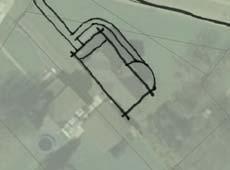
17 Redevelopment District #2 MAP 4: Potential Short-Term Redevelopment Areas* DRAFT Railroad Railroad Railroad Railroad NORTH Created: VANDEWALLE & ASSOCIATES INC * See Downtown w McFarland Market Opportunity Analysis


18 STOUGHTON ROAD 51 Farwell Street Community Entry/Downtown Gateway McFarland Center E BROADHEAD STREET MAIN STREET Historic Downtown Core D Downtown Opportunity Areas & Key Sites Village of McFarland, Wisconsin A F FARWELL STREET C B EXCHANGE STREETT Revised: October 7, 2009 Created: September 25, 2009 VANDEWALLE & ASSOCIATES INC Legend Opportunity Areas Key Sites Feet NORTH
19 Proposed Uses of the Area Proposed Land Uses and Zoning The Redevelopment District is proposed to be developed as shown on Map Five: Proposed Land Uses. Because the District boundary encompasses properties that have historically been developed for over 100 years, very little property remains undeveloped. Some of the properties are underutilized, partially vacant or contain land uses that, once appropriate on the specific locations, are no longer the highest and best uses for the individual parcels. The graphic titled Priority Redevelopment Sites: Redevelopment Objectives and Concept Plans from the Downtown Strategic Market Analysis and Opportunities Assessment, following Map 5, depicts the Priority Redevelopment Sites as contained in the Downtown Strategic Market Analysis and Opportunities Assessment. These redevelopment concepts are the short-term redevelopment priorities. These include redevelopment of the shopping center site with mixed use commercial/residential/community uses. It is a more concentrated, higher density development than what currently exists there. The other three near-term redevelopment projects include more public parking along the railroad corridor, rehabilitation of the Larson House and potential residential development on the corner (Option D). Long-term redevelopment also includes properties west of the post office into higher density residential uses and potentially higher density mixed use commercial/ residential north of the library and Anthony Street. In summary, the proposed land uses include mixed use retail/housing/community services, straight retail/office, public open space/parkland, parking and housing. The current zoning allows the proposed land uses. If different zoning is required to complete a project as outlined in this Project Plan, the necessary steps will be taken to change the zoning to the appropriate zoning classification. Standards of Population Density, Land Coverage and Building Intensity after Development Properties in the redevelopment area will be developed in accord with applicable municipal zoning, subdivision and other land use regulations. The Village of McFarland is focusing on creating an atmosphere where sustainability and a higher density of uses is encouraged. With the demands on natural resources and impacts on the environment, the expectation that development CDA Work Session 17 January 6, 2010
20 and future growth will include using as much sustainable materials and resources as possible, making sure that development is sustainable not just from a construction standpoint but also impact on the environment, using complementary transportation support and other important factors which will continue to keep McFarland ahead in the development arena. The designation of high density mixed use in appropriate areas will be pursued by the Village when meeting with potential developers within the Redevelopment District. Meeting these goals and objectives will further justify the basis for the Redevelopment District and TID. Present and Potential Equalized Value As of January 1, 2009, the total equalized value of the parcels in the redevelopment area is an estimated $9,000,000 (Table 2). Potential Equalized Value The potential equalized value has been projected based on the Proposed Land Uses Map (Map Five). It is projected that the new total equalized value of the redevelopment area could total approximately $40,000,000. There is approximately $9,000,000 of base value in the district as described in the Table Two: Parcel & Valuation Listing. This represents a new tax base increase in equalized value of $31,000,000 for anticipated redevelopment projects. CDA Work Session 18 January 6, 2010


21 Redevelopment District #2 MAP 5: Proposed Land Uses DRAFT Railroad Residential Redevelopment Higher Density Commercial/Residential/ a / Public Uses Railroad Larson House Reuse Public Space Reuse Public Space Reuse Railroad Railroad Residential Reuse NORTH Created: VANDEWALLE & ASSOCIATES INC. 2009


 4 ET Pa")


22 TA PRIORITY REDEVELOPMENT SITES: REDEVELOPMENT OBJECTIVES AND CONCEPT PLANS YL O RO W ISCONSIN S TREE T R AD Village of McFarland, Wisconsin 1-2 Stories (13,000-26,000 sq ft) ~24 Underground Parking Stalls A 10 TA Stories (19,000 sq ft) 4 4 Community, Youth & Senior Center 1 Story (16,000 sq ft) 11 kp ar ki E X I STI N G D AYC A R E 6 3 Stories (36,000 sq ft) 4 ET Pa r 7 Mixed Use/Res. 20 RE ~36 Underground Parking Stalls ng L I BR ARY ST Mixed Use/Res. R 6 AD & ST A R N O L D L A R SO N P ARK Bik ep ath L A K E S TREE T 14 Downtown Gateway Feature REDEVELOPMENT OBJECTIVES A McFarland Center Assume multi-year, phased development Add significant density through residential units, employment and/or visitors Consider a mix of senior housing, multifamily, community center, higher education/vocation training, and related retail/services Bring buildings up to Farwell Street with parking behind and/or under buildings Provide common open space within the site Limit driveways on Farwell Street Realign Taylor Road through the site Reconfigure west end of Taylor Road as parking area for Arnold Larson Park Relocate bike path to north side of park and connect across the tracks down unimproved Wisconsin Street ROW B Bashford Street Parking Area Use attractive landscaping and signage to enhance downtown gateway feature on northeast corner Obtain agreement from railroad to use ROW for improved parking area Buffer/screen parking from Bashford Street Transition bike trail to the north as it heads into Arnold Larson Park Improve west end of parking area concurrent with reuse of Larson House Acquire property on east end and extend parking area concurrent with south side residential redevelopment 24 Do Pub Pawntolic rki w ng n B Pha s Pha e 1 se 2 M ERRILL S TREE T F AR WEL L S TRE E T H I GH S C H O OL MA IN 10 O YL RO lic NG ET 1-2 Stories (30,000 60,000 sq ft) Pu b 7 LO RE 22 7 ke Pa th Senior Care Facility Bi ~32 Underground Parking Stalls 13 ke Pa th Senior Apartments Senior Apartments M AIN S TREE T Bi C Larson House Work with partners to acquire property Work with partners to investigate civic/quasi-public reuses Maintain residential appearance by providing parking across the street Improve site features like walkways and landscaping B AS Larson House Reuse D Future Residential Consolidate two east end properties Consider townhome design with garages in rear Orient front doors to Johnson Street Match Johnson Street setbacks to existing homes Provide vehicular access/parking off of Bashford Street E 0' NORTH H XC AN G E ST E RE C HFO RD S TRE 20 Bike Path ET 5 7 T D Residential Redevelopment 4 Dwelling Units 125' JO H N SO N S TR EE T Revised: November 13, 2009 Created: October 23, 2009 E L EM E N TARY S C HOOL VANDEWALLE & ASSOCIATES INC. 2009
23 VILLAGE OF MCFARLAND REDEVELOPMENT DISTRICT NO. 2 TABLE 2: 2009 PARCEL AND VALUATION LISTING Map # Parcel # Property Owner Property Address Size Land Assessed Imprvmt Assessed Total Assessed Land Equal Imprvmt Equal Total Equal MCFARLAND CENTRE ASSOCIATES LLC 5120 FARWELL ST 5.30 $346,100 $530,000 $876,100 $349,596 $535,354 $884, MCFARLAND, VILLAGE OF 0.35 $0 $0 $0 $0 $0 $ MCFARLAND, VILLAGE OF 5114 FARWELL ST 0.31 $0 $0 $0 $0 $0 $ MCFARLAND CENTRE ASSOCIATES LLC 0.49 $118,200 $0 $118,200 $119,394 $0 $119, UNIV OF WIS MEDICAL FOUNDATION INC 5020 FARWELL ST 0.52 $132,500 $764,100 $896,600 $133,838 $771,818 $905, MCFARLAND CENTRE ASSOCIATES LLC 5220 FARWELL ST 0.53 $133,300 $213,000 $346,300 $134,646 $215,152 $349, ROLAND H LICHTENBERG 5203 FARWELL ST 0.22 $64,600 $88,200 $152,800 $65,253 $89,091 $154, MARILYN PETERS 6002 LAKE ST 0.36 $68,400 $139,300 $207,700 $69,091 $140,707 $209, PAUL T PETERS 6003 LAKE ST 0.12 $43,700 $90,500 $134,200 $44,141 $91,414 $135, PAUL T PETERS 0.15 $39,000 $0 $39,000 $39,394 $0 $39, PAUL T PETERS 0.06 $700 $0 $700 $707 $0 $ MCFARLAND, VILLAGE OF 6002 EXCHANGE ST 0.00 $0 $0 $0 $0 $0 $ EDWARD L MEIER 5303 LONG ST 0.25 $67,200 $84,300 $151,500 $67,879 $85,152 $153, JOSEPH R HARRINGTON 5305 LONG ST 0.25 $67,200 $115,700 $182,900 $67,879 $116,869 $184, PEGGY L CUMMINGS 5311 LONG ST 0.25 $67,200 $83,500 $150,700 $67,879 $84,343 $152, MACO MANAGEMENT CO INC 5315 LONG ST 0.40 $81,100 $243,700 $324,800 $81,919 $246,162 $328, JOSEPH R HARRINGTON 5802 MAIN ST 0.25 $78,300 $256,700 $335,000 $79,091 $259,293 $338, GENERAL TELEPHONE CO 5806 MAIN ST 0.00 $0 $0 $0 $0 $0 $ THOMAS H GUNDERSON JR 5810 MAIN ST 0.25 $67,200 $121,100 $188,300 $67,879 $122,323 $190, MCFARLAND HISTORICAL SOCIETY 5814 MAIN ST 0.00 $0 $0 $0 $0 $0 $ GORDON C LOFGREN 5902 MAIN ST 0.09 $37,800 $148,800 $186,600 $38,182 $150,303 $188, DAPHNE H SCHNEIDER 5906 MAIN ST 0.06 $25,000 $70,100 $95,100 $25,253 $70,808 $96, PHILIP R OLSON 5910 MAIN ST 0.06 $28,600 $131,600 $160,200 $28,889 $132,929 $161, CRYSTAL C H LOKKEN 5803 MAIN ST 0.25 $67,200 $158,300 $225,500 $67,879 $159,899 $227, SHERRY L MARTIN 5802 MILWAUKEE ST 0.25 $67,200 $113,600 $180,800 $67,879 $114,747 $182, MARY V LARSON 5807 MAIN ST 0.25 $78,300 $58,100 $136,400 $79,091 $58,687 $137, JARED TORBLEAU 5806 MILWAUKEE ST 0.25 $67,200 $87,700 $154,900 $67,879 $88,586 $156, DALE S BORCHARDT 5811 MAIN ST 0.25 $67,200 $96,400 $163,600 $67,879 $97,374 $165, ROBERT KALHAGEN 5810 MILWAUKEE ST 0.25 $67,200 $119,400 $186,600 $67,879 $120,606 $188, DALE S BORCHARDT 5813 MAIN ST 0.06 $27,400 $124,100 $151,500 $27,677 $125,354 $153, DALE S BORCHARDT 5819 MAIN ST 0.07 $32,900 $152,400 $185,300 $33,232 $153,939 $187,172
24 VILLAGE OF MCFARLAND REDEVELOPMENT DISTRICT NO. 2 TABLE 2: 2009 PARCEL AND VALUATION LISTING Map # Parcel # Property Owner Property Address Size Land Assessed Imprvmt Assessed Total Assessed Land Equal Imprvmt Equal Total Equal DALE S BORCHARDT 5404 ANTHONY ST 0.11 $44,900 $100,700 $145,600 $45,354 $101,717 $147, ICON REAL ESTATE GROUP LLC 5408 ANTHONY ST 0.25 $67,200 $139,400 $206,600 $67,879 $140,808 $208, JEFFREY D BAUMGARTEN 5813 MILWAUKEE ST 0.25 $67,200 $86,500 $153,700 $67,879 $87,374 $155, SCOTT WARNER 5817 MILWAUKEE ST 0.25 $67,200 $88,200 $155,400 $67,879 $89,091 $156, MICHAEL J CRAPP 5915 EXCHANGE ST 0.00 w/38 $0 $0 $0 $0 $ STEVEN G WASHA 5923 EXCHANGE ST 0.58 $81,900 $251,600 $333,500 $82,727 $254,141 $336, MICHAEL J CRAPP 5915 EXCHANGE ST 0.19 $64,800 $221,600 $286,400 $65,455 $223,838 $289, STEVEN G WASHA 0.00 w/37 $0 $0 $0 $0 $ MICHAEL J CRAPP 5915 EXCHANGE ST 0.00 w/38 $0 $0 $0 $0 $ STEVEN G WASHA 0.00 w/37 $0 $0 $0 $0 $ CENTRAL WAUBESA LUMBER SUPPLY INC 0.00 w/46 $0 $0 $0 $0 $ CENTRAL WAUBESA LUMBER SUPPLY COMPANY 0.00 w/46 $0 $0 $0 $0 $ CHASE LUMBER & FUEL CO INC 5417 LONG ST 0.75 $142,700 $325,700 $468,400 $144,141 $328,990 $473, CHASE LUMBER & FUEL CO INC 0.00 w/46 $0 $0 $0 $0 $ CENTRAL WAUBESA LUMBER SUPPLY INC 5417 LONG ST 0.90 $149,300 $131,700 $281,000 $150,808 $133,030 $283, CENTRAL WAUBESA LUMBER SUPPLY INC 0.00 w/46 $0 $0 $0 $0 $ CENTRAL WAUBESA LUMBER SUPPLY INC 0.00 w/46 $0 $0 $0 $0 $ CENTRAL WAUBESA LUMBER SUPPLY INC 0.00 w/46 $0 $0 $0 $0 $ MCFARLAND, VILLAGE OF 6001 EXCHANGE ST 0.00 $0 $0 $0 $0 $0 $ WI DOT 6001 EXCHANGE ST 0.00 $0 $0 $0 $0 $0 $ MICHAEL J ZIRKEL 5410 BASHFORD ST 0.11 $34,600 $132,600 $167,200 $34,949 $133,939 $168, ROY G HOENECKE 6005 EXCHANGE ST 0.00 $300 $0 $300 $303 $0 $ MCFARLAND, VILLAGE OF 0.00 $0 $0 $0 $0 $0 $ ROY G HOENECKE 6003 EXCHANGE ST 0.27 $67,400 $96,500 $163,900 $68,081 $97,475 $165, THELMA M ALLEN 5403 BASHFORD ST 0.07 $35,800 $101,200 $137,000 $36,162 $102,222 $138, GARRY T MOORE 5407 BASHFORD ST 0.20 $51,600 $76,700 $128,300 $52,121 $77,475 $129, JOHN J GRELL 5411 BASHFORD ST 0.22 $56,500 $18,400 $74,900 $57,071 $18,586 $75, $2,872,100 $5,761,400 $8,633,500 $2,901,111 $5,819,596 $8,720,707
25 Proposed Changes in Zoning, Building Codes, Ordinances, and Maps Zoning Redevelopment in this area will be implemented according to the Village of McFarland Comprehensive Plan and the Village of McFarland TID #4 Project Plan. The current zoning allows the proposed land uses. If different zoning is required to complete a project as outlined in this Project Plan, the necessary steps will be taken to change the zoning to the appropriate zoning classification. Building Codes and Ordinances This redevelopment plan anticipates no changes to Village of McFarland building codes or other ordinances. Should a development proposal come forward that is worthy of code or ordinance consideration, the Village Commissions, Boards and staff will carefully review the request and act in the best interest of the community. Maps This redevelopment plan anticipates no significant changes to the Village of McFarland s official map. Proposed Site Improvements and Utilities Potential project public sector activities include, but are not limited to: Public rights-of-way and utilities improvements Bike/pedestrian improvements Economic development/redevelopment funding General administration, legal, planning, engineering Relocation of displaced individuals and businesses, if applicable A detailed list of project activities is shown in the TID #4 Project Plan, Table One. Central to this redevelopment plan is development and redevelopment funding participation to encourage private sector construction. There are minor public improvements anticipated. Some of these public improvements are tied directly to redevelopment needs. CDA Work Session 23 January 6, 2010
26 Project Financing Financing can be accomplished in different ways. One potential method of financing includes CDA bonding as provided in Sec (5), Wis. Stats. Principal and interest on the CDA bonds can be paid through the following three methods: 1. Revenues generated from the sale or lease of the property; 2. Payments made to the CDA from tax increment revenues from the Village received from increased taxes on new development within TID #4; 3. Receipt of revenues from the TID Economic Development Fund expenditure. However, the Village may choose to bond separately for improvements through their normal borrowing channels. Developer Financed bonds may also be used to pay for improvements. Simply stated, a development agreement between the Village and the Developer is first negotiated and entered into. The development agreement specifies the share of the tax revenue that the Village will reimburse the Developer once the Developer pays the taxes as billed by the Village. The Developer then borrows the funds. The improvements (buildings, etc.) are constructed and a tax bill stating the amount of property tax owed is sent to the Developer/property owner. The Developer pays the taxes and the Village reimburses the previously-agreed upon amount to the Developer. This reimbursement continues until the agreement has been fulfilled or the TID is retired, whichever occurs first. Performance Standards Throughout the project, developers and contractors will adhere to the provisions of applicable municipal ordinances and codes including, but not limited to, the zoning ordinance, subdivision and platting ordinance, building and construction codes, traffic ordinances, site plan review regulations and deed restrictions. Plan Amendments This plan may be amended at any time in accordance with the provisions of Section (11), Wis. Stats. If the plan is modified, a public hearing will be conducted by the CDA. All modifications to the plan must be recommended by the CDA, reviewed by the Plan Commission, and approved by the Village Board by a twothirds majority. CDA Work Session 24 January 6, 2010
27 Relocation of Displaced Persons and Businesses If applicable, persons displaced by project activities will be relocated in accordance with applicable federal and state laws and regulations. Relocation plans for the project will be filed with the Department of Commerce, Relocation Unit, Division of Community Development. These plans will be the basis for all relocation payments made as part of this project. Land Disposition It is possible that either the Village or the CDA will acquire land as a result of implementation of this plan. All negotiations will follow the legal requirements imposed on the Village and CDA for land acquisition. Termination This Redevelopment Plan and District may terminate on the date of retirement of TID #4. However, it could remain in effect for a longer period of time upon decision by the Village Board. CDA Work Session 25 January 6, 2010
28 Appendix A. Blight Determination The Blight Determination was originally conducted for TID No. 4, Village of McFarland. It was undertaken and documented to assist in making the TID No. 4 Project Plan stand alone as an implementable document. The Blight Determination is also included in this. Urban redevelopment is done to effect removal of blight and to promote economic development, enhance community character and increase quality of life. Vandewalle & Associates, a Madison-based urban planning and economic development consulting firm, evaluated the property proposed for inclusion in the redevelopment plan and determined that the properties contained in the redevelopment area meet the statutory requirement of a redevelopment district. The TID project plan states that not less than 50% by area of the properties within the proposed redevelopment area are blighted and in need of rehabilitation within the meaning of the criteria set forth in Sections and , Wis. Stats. in that they demonstrate deteriorating architecture, obsolete and vacant buildings that are a physical hazard, inappropriate land uses, economically obsolete uses, environmental concerns and poor or unsafe access to the river and other statutory factors meeting the definition of blight that do not comply with adopted Village planning documents. Redevelopment blight findings require that a preponderance of blight be found within the district boundary. Because the Blight Determination found more than 50% of the area deemed blighted, this fulfills the requirements of declaring a preponderance be declared blighted. Some properties that are in good physical condition, are properly maintained and meet the land uses appropriate for the district may be included in the district. The purpose for inclusion of these non-blighted properties is to comprehensively address redevelopment in the long-range planning process and encourage other property owners to upgrade their properties in order to accomplish the goals and objectives of this TID or due to the necessity of the boundary being contiguous. The criterion for defining conditions of blight in this analysis is the statutory definition of "blighted area" appearing in Sections and , Wis. Stats., which read as follows: Section , Wis. Stats. Blighted area means any area, including a slum area, in which a majority of the structures are residential or in which there is a predominance of buildings or improvements, whether residential or nonresidential, which, by reason of dilapidation, deterioration, age or obsolescence, inadequate provision for ventilation, light, air, sanitation, or open spaces, high density of population and overcrowding, or the existence of conditions which endanger life or property by fire and other causes, or any combination of these factors, is conducive to ill health, transmission of disease, infant CDA Work Session 26 January 6, 2010
29 mortality, juvenile delinquency, or crime, and is detrimental to the public health, safety, morals or welfare. Section (2m)(b), Wis. Stats. Blighted area means any of the following: (bm) 1. An area, including a slum area, in which there is a predominance of buildings or improvements, whether residential or non-residential, which by reason of dilapidation, deterioration, age or obsolescence, inadequate provision for ventilation, light, air sanitation, or open spaces, high density of population and overcrowding, or the existence of conditions which endanger life or property by fire and other causes, or any combination of such factors is conducive to ill health, transmission of disease, infant mortality, juvenile delinquency, or crime, and is detrimental to the public health, safety, morals or welfare. 2. An area which by reason of the presence of a substantial number of substandard, slum, deteriorated or deteriorating structures, predominance of defective or inadequate street layout, faulty lot layout in relation to size, adequacy, accessibility or usefulness, unsanitary or unsafe conditions, deterioration of site or other improvements, diversity of ownership, tax or special assessment delinquency exceeding the fair value of the land, defective or unusual conditions of title, or the existence of conditions which endanger life or property by fire and other causes, or any combination of such factors, substantially impairs or arrests the sound growth of a Village, retards the provision of housing accommodations or constitutes an economic or social liability and is a menace to the public health, safety, morals or welfare in its present condition and use. 3. An area which is predominantly open and which because of obsolete platting, diversity of ownership, deterioration of structures or of site improvements, or otherwise, substantially impairs or arrests the sound growth of the community. Blighted property means any property within a Village, whether residential or nonresidential, which by reason of dilapidation, deterioration, age or obsolescence, inadequate provisions for ventilation, light, air or sanitation, high density of population and overcrowding, or the existence of conditions which endanger life or property by fire and other causes, or any combination of such factors, is conducive to ill health, transmission of disease, infant mortality, juvenile delinquency or crime, and is detrimental to the public health, safety, morals or welfare, or any property which by reason of faulty lot layout in relation to size, adequacy, accessibility or usefulness, unsanitary or unsafe conditions, deterioration of site CDA Work Session 27 January 6, 2010
30 General Description of Site or other improvements, diversity of ownership, tax or special assessment delinquency exceeding the fair market value of the land, defective or unusual conditions of title, or the existence of conditions which endanger life or property by fire and other causes, or any combination of such factors, substantially impairs or arrests the sound growth of a Village, retards the provisions of housing accommodations or constitutes an economic or social liability and is a menace to the public health, safety, morals or welfare in its present condition and use, or any property which is predominantly open and which because of obsolete platting, diversity of ownership, deterioration of structures or of site improvements, or otherwise, substantially impairs or arrests the sound growth of the community. The following pages include a parcel-by-parcel analysis of the general condition of existing structures and improvements. A detailed physical analysis has been undertaken as a part of the redevelopment process. Implementation of the Redevelopment and TID Plans, including such activities such as appraisals and environmental examinations, may identify additional information that will substantiate the blight findings found in this analysis. The blight finding made in this report is primarily based on the broader conditions within the overall district. These conditions emphasize inconsistent land use patterns, properties not being used to their highest and best use, visually and/or physically blighted properties, environmental concerns, obsolete land ownership, substandard buildings that are hazardous to the public welfare and transportation problems that are substantially impairing the sound growth and expansion of this area of the community. Some or all of these areas of blight, as defined above, may be present in the redevelopment area. Parcel Analysis and Assessment Table 3 is a review of the parcels within TID #4 and Redevelopment District #2. Parcels have been reviewed and critiqued on an individual ownership basis. Please note that parcel numbers on Map 6 are the original map/parcel numbers tied to Table 3 information. Since TID #4 was created, the assessor has changed some of the mapping. Consequently, Table 3 and Map 6 numbers will not correspond directly to parcel and map numbers in the remaining two tables and five maps in the Redevelopment Project Plan. However, tax key numbers have remained the same and parcels can be cross-referenced using names and/or tax key numbers. CDA Work Session 28 January 6, 2010


31 VILLAGE OF MCFARLAND TID #4 MAP 5: BLIGHTED AREA PARCELS MAP LEGEND CREATED: PARCEL BOUNDARIES TID #4 PROPOSED BOUNDARY BLIGHTED AREA ' ' 150' 300'
URBAN REVITALIZATION PLAN CITY OF DECORAH, IOWA 2014 DECORAH HOUSING URBAN REVITALIZATION AREA ADOPTED NOVEMBER 3, 2014
 URBAN REVITALIZATION PLAN CITY OF DECORAH, IOWA 2014 DECORAH HOUSING URBAN REVITALIZATION AREA ADOPTED NOVEMBER 3, 2014 Public Hearing held September 2, 2014 Second Public Hearing held October 6, 2014
RICHFIELD WAY REDEVELOPMENT PLAN
 VILLAGE OF MENOMONEE FALLS, WISCONSIN RICHFIELD WAY REDEVELOPMENT PLAN Prepared by: Village of Menomonee Falls, Wisconsin Community Development Authority Approved by the Community Development Authority
Downtown Meridian Urban Renewal Area URBAN RENEWAL ELIGIBILITY REPORT. Prepared for The City of Meridian and The Meridian Development Corporation
 Downtown Meridian Urban Renewal Area URBAN RENEWAL ELIGIBILITY REPORT Prepared for The City of Meridian and The Meridian Development Corporation by McKibben + Cooper Architects June 19, 2002 Authorization
H 7291 S T A T E O F R H O D E I S L A N D
 LC000 01 -- H 1 S T A T E O F R H O D E I S L A N D IN GENERAL ASSEMBLY JANUARY SESSION, A.D. 01 A N A C T RELATING TO TOWNS AND CITIES -- REDEVELOPMENT AGENCIES AND PROJECTS Introduced By: Representatives
INTRODUCTION INTRODUCTION REDEVELOPMENT AUTHORITIES, COMMUNITY DEVELOPMENT AUTHORITIES, AND HOUSING AUTHORITIES
 REDEVELOPMENT, COMMUNITY DEVELOPMENT, AND HOUSING Scott R. Letteney City Attorney Nicole F. Larsen Deputy City Attorney City of Racine City Attorney s Office Municipal Attorneys Institute June 15, 2017
Summary. Draft Redevelopment Plan Summary Flowery Branch Tax Allocation District # 1:
 Summary Draft Redevelopment Plan Summary Flowery Branch Tax Allocation District # 1: Flowery Branch Tax Allocation District Old Town and Commercial Gateways 1 Public Hearing Presentation November 21, 2007
Village of Port Jefferson Urban Renewal Plan
 Urban Renewal Plan Village of Port Jefferson Urban Renewal Plan Port Jefferson, New York PREPARED FOR Village of Port Jefferson Village Board 121 West Broadway Port Jefferson, NY 11777 631.473.4724 PREPARED
City of Lawrence Neighborhood Revitalization Plan and Program: 1101/1115 Indiana Street Lawrence, KS
 City of Lawrence Neighborhood Revitalization Plan and Program: 1101/1115 Indiana Street Lawrence, KS Definition: Area - used interchangeably with Property, referring to the property located at 1101/1115
Redevelopment District No. 1 Project Plan. City of Wauwatosa
 City of Wauwatosa City Council Action: November 3, 2015 Community Development Authority Certification: April 25, 2016 Prepared by: Vandewalle & Associates 120 East Lakeside Street 247 Freshwater Way, Suite
PREPARED BY TREASURE COAST REGIONAL PLANNING COUNCIL
 PREPARED BY TREASURE COAST REGIONAL PLANNING COUNCIL OCTOBER 12, 2017 What is a Community Redevelopment Agency? Definition of a CRA: A dependent special district in which any future increases in property
THIRD RESTATED URBAN REVITALIZATION PLAN. Citywide Urban Revitalization Area
 THIRD RESTATED URBAN REVITALIZATION PLAN for the Citywide Urban Revitalization Area City of Des Moines, Iowa As adopted and amended on October 26, 2015, by Roll Call Nos. 15-1816 and 15-1818. As further
Common July 24, 2017 PROJECT
 CITY OF WAUSAU TAX INCREMENT DISTRICT ELEVEN PROJECT PLAN Economic Development Committee June 6, 2017 Finance Committee June 12, 2017 Plan Commission: June 20, 2017 Common Council: July 18, 2017 Joint
Understanding Texas TIRZ Statute Chapter 311 Texas Tax Code
 CDFA/TEDC TIRZ SEMINAR Understanding Texas TIRZ Statute Chapter 311 Texas Tax Code Clark Stockton Lord Constitutional Authority The legislature by general law may authorize an incorporated city or town
January 1, 2010 thru March 31, 2010 Performance Report
 Grantee: Wyoming State Program Grant: B-08-DN-56-0001 January 1, 2010 thru March 31, 2010 Performance Report Grant Number: B-08-DN-56-0001 Grantee Name: Wyoming State Program Grant : $19,600,000.00 Grant
******************************************************************************
 AN ORDINANCE OF THE CITY COUNCIL OF THE CITY OF BAYTOWN, TEXAS, EXCLUDING LAND FROM REINVESTMENT ZONE NO. ONE, CITY OF BAYTOWN, TEXAS; INCLUDING LAND WITHIN THE ZONE; EXTENDING THE TERM OF SUCH ZONE; APPROVING
A PRELIMINARY FINANCIAL AND ECONOMIC REDEVELOPMENT FEASIBILITY STUDY FOR THE CITY OF FERNLEY, NEVADA
 TECHNICAL REPORT UCED 2015/16-07 A PRELIMINARY FINANCIAL AND ECONOMIC REDEVELOPMENT FEASIBILITY STUDY FOR THE CITY OF FERNLEY, NEVADA UNIVERSITY OF NEVADA, RENO A PRELIMINARY FINANCIAL AND ECONOMIC REDEVELOPMENT
Redevelopment Project Plan and Eligibility Report for the: Cook County Project Area. Village of East Dundee, Illinois. Draft: July 18, 2012
 for the: Cook County Project Area Village of East Dundee, Illinois Draft: Created By: Vandewalle & Associates 2012 Table of Contents TABLE OF CONTENTS Table of Contents... i Executive Summary... 1 Part
Hennepin County Department of. Housing, Community Works and Transit. Transit Oriented Development (TOD) Guidelines
 Guidelines") Hennepin County Department of Housing, Community Works and Transit 2007 Transit Oriented Development (TOD) Guidelines Hennepin County Transit Oriented Development (TOD) Bond Funds Hennepin County Housing,
Hennepin County Department of Housing, Community Works and Transit 2007 Transit Oriented Development (TOD) Guidelines Hennepin County Transit Oriented Development (TOD) Bond Funds Hennepin County Housing,
July 1, 2018 thru September 30, 2018 Performance Report
 Grantee: Grant: Milwaukee, WI B-08-MN-55-0006 July 1, 2018 thru September 30, 2018 Performance Report 1 Grant Number: B-08-MN-55-0006 Grantee Name: Milwaukee, WI Grant Award Amount: $9,197,465.00 LOCCS
Cent ral Neighborhoods U rban Ren ewal Plan ( )
") Central Neighborhoods Urban Renewal Plan City of Golden, Colorado Cent ral Neighborhoods U rban Ren ewal Plan (4.18.20 1 3) 010252\0001\1819714.2 Central Neighborhoods Urban Renewal Plan City of Golden,
Central Neighborhoods Urban Renewal Plan City of Golden, Colorado Cent ral Neighborhoods U rban Ren ewal Plan (4.18.20 1 3) 010252\0001\1819714.2 Central Neighborhoods Urban Renewal Plan City of Golden,
WASHTENAW COUNTY BROWNFIELD REDEVELOPMENT AUTHORITY ACT 381 WORK PLAN TO CONDUCT ELIGIBLE DEQ RESPONSE AND/OR MSF NON-ENVIRONMENTAL ACTIVITIES
 WASHTENAW COUNTY BROWNFIELD REDEVELOPMENT AUTHORITY ACT 381 WORK PLAN TO CONDUCT ELIGIBLE DEQ RESPONSE AND/OR MSF NON-ENVIRONMENTAL ACTIVITIES 400 NORTH RIVER STREET THE HISTORIC THOMPSON BLOCK REDEVELOPMENT
CITY OF ANDOVER NEIGHBORHOOD REVITALIZATION PLAN
 CITY OF ANDOVER NEIGHBORHOOD REVITALIZATION PLAN Adopted August 28, 2018 Expires December 31, 2021 Attorney General Office Approved, 2019 CITY OF ANDOVER, KANSAS NEIGHBORHOOD REVITALIZATION PLAN PURPOSE
74af ANTELOPE VALLEY REDEVELOPMENT PLAN
 74af T. Telegraph District Phase 2: Telegraph Flats & Telegraph Lofts East 1. Project Area Description Phase 2 will include two building subphase areas with connecting streetscape enhancements: The Telegraph
ORDINANCE NO (As Amended)
") ORDINANCE NO. 01-2015 (As Amended) To Amend the Official Zoning Map of the City of Worthington, Ohio, to Change Zoning of Certain Land from the C-3 District (Institutions and Office), AR-4.5 District (Low
ORDINANCE NO. 01-2015 (As Amended) To Amend the Official Zoning Map of the City of Worthington, Ohio, to Change Zoning of Certain Land from the C-3 District (Institutions and Office), AR-4.5 District (Low
Blight and Substandard Study City of Blair, Nebraska
 Blight and Substandard Study City of Blair, Nebraska 2014 JEO Consulting Group, Inc. Project No. 131365.00 Adopted, 2014 Resolution No. Introduction Introduction Purpose of the Study This Blair Blight
THE REDEVELOPMENT PLAN
 PAGE 37 THE REDEVELOPMENT PLAN FUTURE LAND USE The Silver Terrace Redevelopment Area is currently designated as Redevelopment Area #4 on the City of Delray Beach Future Land Use Map (FLUM). This designation
CITY OF HIAWATHA, IOWA TOWN VILLAGE CENTER URBAN REVITALIZATION PLAN. for the TOWN VILLAGE CENTER URBAN REVITALIZATION AREA
 CITY OF HIAWATHA, IOWA TOWN VILLAGE CENTER URBAN REVITALIZATION PLAN for the TOWN VILLAGE CENTER URBAN REVITALIZATION AREA 2018 1 INTRODUCTION The Urban Revitalization Act, Chapter 404 of the Code of Iowa,
VILLAGE OF DOWNERS GROVE PLAN COMMISSION VILLAGE HALL COUNCIL CHAMBERS 801 BURLINGTON AVENUE. June 2, :00 p.m. AGENDA
 VILLAGE OF DOWNERS GROVE PLAN COMMISSION VILLAGE HALL COUNCIL CHAMBERS 801 BURLINGTON AVENUE June 2, 2014 7:00 p.m. AGENDA 1. Call to Order 2. Roll Call a. Pledge of Allegiance 3. Approval of Minutes April
CITY OF STEVENS POINT, WISCONSIN Territory Amendment to Tax Incremental District No. 6
 CITY OF STEVENS POINT, WISCONSIN Territory Amendment to Tax Incremental District No. 6 September 15, 2009 Joint Review Board Organizational Meeting Held: September 15, 2009 Public Hearing Held: September
COMMUNICATION URBAN DESIGN REVIEW BOARD CITY OF DES MOINES, IOWA NOVEMBER 1, 2016, 2016 MEETING
 COMMUNICATION URBAN DESIGN REVIEW BOARD CITY OF DES MOINES, IOWA NOVEMBER 1, 2016, 2016 MEETING Subject: Recommendation Prepared by: PRELIMINARY DESIGN AND FINANCIAL REVIEW 401 SE 6 TH STREET- CONNOLLY
CITY OF LOGAN REDEVELOPMENT AGENCY. A Resolution approving the Auto Mall Community Development Project Area Plan
 -~ LOGAN CITY UNITED IN HRVICE fstt,blished 18t6 CITY OF LOGAN REDEVELOPMENT AGENCY Resolution No. IS-03 RDA A Resolution approving the Auto Mall Community Development Project Area Plan WHEREAS, the Redevelopment
Frequently Asked Questions
 The City of Brockton recently unveiled three documents aimed at revitalizing our downtown. The Downtown Action Strategy sets a vision for downtown and lays out the actions needed to achieve that vision.
Infill Development Incentive Policy
 Infill Development Incentive Policy PURPOSE It is the policy of the City of El Paso to provide incentives to promote infill development, reduce sprawl, increase the availability of attainable housing and
KANSAS CITY, MISSOURI HOMESTEADING AUTHORITY POLICIES AND PROCEDURES
 DEFINITIONS KANSAS CITY, MISSOURI HOMESTEADING AUTHORITY POLICIES AND PROCEDURES Property costs: Property costs are those costs associated with the acquisition of a parcel of property. Project costs: Project
C.D. No ORDINANCENO.: 3217 INTRODUCEDBY: Vigil
 C.D. No. 2012-1 64 ORDINANCENO.: 3217 INTRODUCEDBY: Vigil AN ORDINANCE MAKING CERTAIN LEGISLATIVE FINDINGS REGARDING BLIGHT AND APPROVING THE SOUTH THORNTON URBAN RENEWAL PLAN. WHEREAS, an urban renewal
SERVICE & IMPROVEMENT PLAN AND ASSESSMENT PLAN:
 DOWNTOWN MIDLAND MANAGEMENT DISTRICT SERVICE & IMPROVEMENT PLAN AND ASSESSMENT PLAN: 2010-2019 August 25, 2009 Table of Contents 1. Introduction...1 2. Background: The First Five Years...2 3. Service &
CITY OF ANDOVER NEIGHBORHOOD REVITALIZATION PLAN
 CITY OF ANDOVER NEIGHBORHOOD REVITALIZATION PLAN Adopted August 25, 2015 Expires December 31, 2018 Attorney General Office: Adopted CITY OF ANDOVER, KANSAS NEIGHBORHOOD REVITALIZATION PLAN PURPOSE This
DIVISION 1 PURPOSE OF DISTRICTS
 ARTICLE 2 ZONING DISTRICTS AND MAP DIVISION 1 PURPOSE OF DISTRICTS Section 2.101 Zoning Districts. For the purpose of this Ordinance, the City of Richmond is hereby divided into districts as follows: DISTRICT
TAX INCREMENT FINANCING PLAN PARAGON STAR, LLC
 TAX INCREMENT FINANCING PLAN PARAGON STAR, LLC JANUARY 6, 2016 FEBRUARY 17, 2016 1 TABLE OF CONTENTS I. DEFINITIONS 4 II. TAX INCREMENT FINANCING 6 III. GENERAL DESCRIPTION OF REDEVELOPMENT PLAN AND PROJECT
PLANNING COMMISSION REPORT Regular Agenda Public Hearing Item
 PC Staff Report 6/20/16 Item No. 4-1 PLANNING COMMISSION REPORT Regular Agenda Public Hearing Item PC Staff Report 06/20/16 ITEM NO. 4: IG to CS 1.56 ACRES; 706 E 23 RD STREET (MKM) : Consider a request
PLANNING COMMISSION STAFF REPORT
 PLANNING COMMISSION STAFF REPORT REZONING CASE: RZ-16-001 REPORT DATE: March 8, 2016 CASE NAME: Trailbreak Partners Rezoning PLANNING COMMISSION DATE: March 16, 2016 ADDRESSES OF REZONING PROPOSAL: 5501
NEIGHBORHOOD DEVELOPMENT PLAN (Urban Renewal Plan)
") NEIGHBORHOOD DEVELOPMENT PLAN (Urban Renewal Plan) March 7, 1972, As Amended Effective to December 31, 2019 CITY OF HAMILTON PLANNING DEPARTMENT February 21, 2019 2 TABLE OF CONTENTS A. Description of
NEIGHBORHOOD DEVELOPMENT PLAN (Urban Renewal Plan) March 7, 1972, As Amended Effective to December 31, 2019 CITY OF HAMILTON PLANNING DEPARTMENT February 21, 2019 2 TABLE OF CONTENTS A. Description of
Proposed Development at Ajax Plaza Windcorp Grand Harwood Place Ltd.
 Proposed Development at Ajax Plaza Windcorp Grand Harwood Place Ltd. Presentation to Ajax Council July 4, 2013 Introduction 1. Background 2. Planning Policies and Regulations 3. Downtown Community Improvement
PLANNING COMMISSION REPORT Regular Agenda - Public Hearing Item
 Z-14-00056 Item No. 1-1 PLANNING COMMISSION REPORT Regular Agenda - Public Hearing Item PC Staff Report 4/21/2014 ITEM NO. 1: RSO TO CN1;.126 ACRES; 512 & 514 LOCUST ST (DRG) Z-14-00056: Consider a request
Chapter 5: Testing the Vision. Where is residential growth most likely to occur in the District? Chapter 5: Testing the Vision
 Chapter 5: Testing the Vision The East Anchorage Vision, and the subsequent strategies and actions set forth by the Plan are not merely conceptual. They are based on critical analyses that considered how
8.5.1 R1, Single Detached Residential District
 8.5.1 R1, Single Detached Residential District The purpose of this district is to provide for residential development in the form of single detached dwellings. Dwelling, Single Detached Home Business,
Appendix A: Guide to Zoning Categories Prince George's County, Maryland
 Appendix A: Guide to Zoning Categories Prince George's County, Maryland RESIDENTIAL ZONES 1 Updated November 2010 R-O-S: Reserved Open Space - Provides for permanent maintenance of certain areas of land
Appendix A. A.1 Finding of Necessity Resolution. A.2 Urban Redevelopment Plan Adoption Resolution. A.3 Urban Redevelopment Agency Resolution
 Appendix A A.1 Finding of Necessity Resolution A.2 Adoption Resolution A.3 Urban Redevelopment Agency Resolution Appendix A 1 Appendix A 2 Appendix A 3 Appendix A 4 Appendix A 5 Appendix A 6 RESOLUTION
CITY OF EAST PEORIA, ILLINOIS COSTCO AREA BUSINESS DISTRICT DEVELOPMENT AND REDEVELOPMENT PLAN
 CITY OF EAST PEORIA, ILLINOIS COSTCO AREA BUSINESS DISTRICT DEVELOPMENT AND REDEVELOPMENT PLAN I. INTRODUCTION The City of East Peoria (the City ) is located in Tazewell County, Illinois. In order to encourage
DRAFT. Conservation Area Analysis. for the Southwest Corner of Shawnee Mission Parkway & Maurer Road. Shawnee, Kansas. October 2014.
 Conservation Area Analysis for the Southwest Corner of Shawnee Mission Parkway & Maurer Road Shawnee, Kansas October 2014 DRAFT Prepared by: Polsinelli PC, Development Analysis Department 99 CONSERVATION
Glendale Housing Development Project Plan
 Glendale Housing Development Project Plan Draft for Public Review May 29, 2015 Table of Contents I. Introduction... 1 II. Description of Project... 1 A. Boundary of Housing Development Project... 1 B.
Study Area Description Study Area Context Existing Land Use and Zoning Districts
 TABLE OF CONTENTS Table of Contents SECTION I: INTRODUCTION Definition of Blight Study Methodology Report Format SECTION II: AREA OVERVIEW AND DESCRIPTION Study Area Description Study Area Context Existing
Planning Justification Report
 Planning Justification Report Kellogg s Lands City of London E&E McLaughlin Ltd. June 14, 2017 Zelinka Priamo Ltd. Page i TABLE OF CONTENTS Page No. 1.0 2.0 2.1 2.2 3.0 4.0 5.0 5.1 5.2 5.3 5.4 5.5 5.6
January 1, 2018 thru March 31, 2018 Performance Report
 Grantee: Grant: Milwaukee, WI B-11-MN-55-0006 January 1, 2018 thru March 31, 2018 Performance Report 1 Grant Number: B-11-MN-55-0006 Grantee Name: Milwaukee, WI Grant Award Amount: $2,687,949.00 LOCCS
MIDWAY CITY Municipal Code
 MIDWAY CITY Municipal Code TITLE 9 ANNEXATION CHAPTER 9.01 PURPOSE CHAPTER 9.02 GENERAL REQUIREMENTS CHAPTER 9.03 PROPERTY OWNER INITIATION OF ANNEXATION CHAPTER 9.04 PROCEDURES FOR CONSIDERATION OF PETITION
Telephone AC / 21,960 SF G-MU-3 G-MX-3
 Zone Map Amendment (Rezoning) - Application PROPERTY OWNER INFORMATION* CHECK IF POINT OF CONTACT FOR APPLICATION Property Owner Name Siddhartha Rathod Address City, State, Zip Telephone Email COMMUNITY
Five Year Implementation Plan 2010/11 to 2014/15
 Central San Rafael Redevelopment Project Five Year Implementation Plan 2010/11 to 2014/15 PURPOSE This is the Central San Rafael Redevelopment Project Five Year Implementation Plan for the period of fiscal
Staff Report: Date: Applicant: Property Identification: Acreage of Request: Current Zoning of Requested Area: Requested Action: Attached:
 Staff Report: Completed by Jeff Palmer Director of Planning & Zoning Date: November 7, 2018, Updated November 20, 2018 Applicant: Greg Smith, Oberer Land Developer agent for Ronald Montgomery ET AL Property
When the Plan is not Enough
 When the Plan is not Enough Christine Maguire, AICP, EDFP Redevelopment Manager Planning & Community Development 1 Rail~Volution 2012 When the Plan is Not Enough: Garland, TX 16 October 2012 About the
LINCOLN CORRIDOR REDEVELOPMENT PROJECT UPDATE FOR DOWNTOWN GATEWAY FOCUS AREA
 ITEM: 51 BACKGROUND: Staff Report LINCOLN CORRIDOR REDEVELOPMENT PROJECT UPDATE FOR DOWNTOWN GATEWAY FOCUS AREA March 27, 2018 The City has been working for two years to develop, adopt, and implement the
2015 Downtown Parking Study
 2015 Downtown Parking Study City of Linden Genesee County, Michigan November 2015 Prepared by: City of Linden Downtown Development Authority 132 E. Broad Street Linden, MI 48451 www.lindenmi.us Table of
REZONING GUIDE. Zone Map Amendment (Rezoning) - Application. Rezoning Application Page 1 of 3. Return completed form to
 - Application. Rezoning Application Page 1 of 3. Return completed form to") COMMUNITY PLANNING & DEVELOPMENT REZONING GUIDE Rezoning Application Page 1 of 3 Zone Map Amendment (Rezoning) - Application PROPERTY OWNER INFORMATION* PROPERTY OWNER(S) REPRESENTATIVE** CHECK IF POINT
COMMUNITY PLANNING & DEVELOPMENT REZONING GUIDE Rezoning Application Page 1 of 3 Zone Map Amendment (Rezoning) - Application PROPERTY OWNER INFORMATION* PROPERTY OWNER(S) REPRESENTATIVE** CHECK IF POINT
South Sprecher Road, Madison, WI
 August 14, 2018 Letter of Intent Land Use Application Development Name: Former Rodefeld Farm South Sprecher Road, Madison, WI Project Summary The proposed project consists of two separate elements at this
A. Land Use Relationships
 Chapter 9 Land Use Plan A. Land Use Relationships Development patterns in Colleyville have evolved from basic agricultural and residential land uses, predominate during the early stages of Colleyville
DESCRIPTION OF THE DISTRICT
 DESCRIPTION OF THE DISTRICT The project plan for City of Wausau, Tax Increment District #11 has been prepared in compliance with Wisconsin Statutes Chapter 66.1105(4). The plan establishes the need for
CHAUTAUQUA COUNTY LAND BANK CORPORATION
 EXHIBIT H CHAUTAUQUA COUNTY LAND BANK CORPORATION LAND ACQUISITION AND DISPOSITION POLICIES AND PRIORITIES November 14, 2012 *This document is intended to provide guidance to the Chautauqua County Land
TABLE OF CONTENTS. I. Introduction II. Statutory Basis for Business District III. Blight Analysis... 7
 AI RPORT BUSI NESSDI STRI CT REDEVELOPMENT PLAN&PROJECT Febr uar y12,2018 TheVi l l ageof BETHALTO,I L TABLE OF CONTENTS SECTION PAGE I. Introduction... 2 II. Statutory Basis for Business District... 3
Request for Proposals Gabbard Building 106 Judiciary Street Aurora, Indiana. Deadline for response October 19, 2015, 8:30 a.m.
 Request for Proposals Gabbard Building 106 Judiciary Street Aurora, Indiana Deadline for response October 19, 2015, 8:30 a.m. The Aurora Historic Preservation Commission is soliciting proposals on the
MISSION STATEMENT LCLB PURPOSE PRIORITIES & POLICIES. 1. Policies Governing the Acquisition of Properties
 MISSION STATEMENT The LAWRENCE COUNTY LAND BANK (LCLB) will strategically acquire distressed properties and return them to productive, tax-paying use. The LCLB will: reduce blight; stabilize neighborhoods
O.C.G.A. TITLE 36 Chapter 61. GEORGIA CODE Copyright 2012 by The State of Georgia All rights reserved.
 O.C.G.A. TITLE 36 Chapter 61 GEORGIA CODE Copyright 2012 by The State of Georgia All rights reserved. *** Current Through the 2011 Extraordinary Session *** TITLE 36. LOCAL GOVERNMENT PROVISIONS APPLICABLE
Riverworks Business Improvement District II #36 Year 2011 Operating Plan
 Riverworks Business Improvement District II #36 Year 2011 Operating Plan Riverworks Business Improvement District II Proposed Annual Operating Plan Year Six (2011) Introduction In 1984, the Wisconsin Legislature
GUIDELINES AND CRITERIA. For Granting Tax Abatement in the North Killeen Revitalization Area. Designated by the City of Killeen, Texas
 GUIDELINES AND CRITERIA For Granting Tax Abatement in the North Killeen Revitalization Area Designated by the City of Killeen, Texas Under Tax Code, Chapter 312 I. PURPOSE The designation of a Tax Abatement
A M H E R S T
 Town of TOWN HALL 4 Boltwood Avenue Amherst, MA 01002-2351 A M H E R S T Massachusetts PLANNING DEPARTMENT (413) 259-3040 (413) 259-2410 [Fax] planning@amherstma.gov April 7, 2015 Memo To: From: Subject:
THE REDEVELOPMENT AGENCY OF THE CITY OF SAN JOSE
 BOARD AGENDA: 4/27/10 ITEM: 8.1 THE REDEVELOPMENT AGENCY OF THE CITY OF SAN JOSE MEMORANDUM TO: HONORABLE MAYOR, CITY COUNCIL, AND AGENCY BOARD SUBJECT: SEE BELOW FROM: HARRY S. MAVROGENES EXECUTIVE DIRECTOR
ARTICLE 14 PLANNED UNIT DEVELOPMENT (PUD) DISTRICT
 DISTRICT") ARTICLE 14 PLANNED UNIT DEVELOPMENT (PUD) DISTRICT Section 14.01 Intent. It is the intent of this Article to allow the use of the planned unit development (PUD) process, as authorized by the Michigan Zoning
ARTICLE 14 PLANNED UNIT DEVELOPMENT (PUD) DISTRICT Section 14.01 Intent. It is the intent of this Article to allow the use of the planned unit development (PUD) process, as authorized by the Michigan Zoning
Report to the Plan Commission December 19, 2011
 Report to the Plan Commission Legistar I.D. #24825, Extraterritorial Certified Survey Map Requested Action: Consideration of a two-lot Certified Survey Map (CSM) of the Keryluk-Wee property located at,,
Summary Report on the Economic Impact of the State Center Project Baltimore, MD
 Summary Report on the Economic Impact of the State Center Project Baltimore, MD Prepared for: Maryland Department of Transportation Prepared by: BAE Urban Economics March 2011 Summary of Key Findings Phase
Delta Urban Renewal Authority Blight Study
 Delta Urban Renewal Authority Blight Study February 2017 1 Table of Contents 1. Introduction.3 1.1 Purpose..3 1.2 Colorado Urban Renewal Law..3 1.3 Study Methodology..5 2. Study Area Analysis.6 2.1 Study..6
Summary of Tower Road Property Planning and Maintenance
 Issue Background Findings Conclusions Recommendations Responses Attachments Summary of Tower Road Property Planning and Maintenance Tower Road Property Needs Master Planning and Maintenance Plans Issue
Jacobs Landing Rehabilitation Plan
 Jacobs Landing Rehabilitation Plan Township of Woodbridge Prepared by: Township of Woodbridge Department of Planning & Development June 2015 ADOPTED by Township of Woodbridge Planning Board ADOPTED by
7. IMPLEMENTATION STRATEGIES
 7. IMPLEMENTATION STRATEGIES A. GENERAL APPROACH FOR IMPLEMENTATION Implementing the plan will engage many players, including the Municipality of Anchorage (MOA), the Government Hill Community Council,
PIN , Part 1, Plan SR-713 in Lot 2, Concession 5, Township of McKim (1096 Dublin Street, Sudbury)
") STAFF REPORT Applicant: Dalron Construction Limited Location: PIN 02124-0103, Part 1, Plan SR-713 in Lot 2, Concession 5, Township of McKim (1096 Dublin Street, Sudbury) Official Plan and Zoning By-law:
STAFF REPORT Applicant: Dalron Construction Limited Location: PIN 02124-0103, Part 1, Plan SR-713 in Lot 2, Concession 5, Township of McKim (1096 Dublin Street, Sudbury) Official Plan and Zoning By-law:
ARTICLE B ZONING DISTRICTS
 ARTICLE B ZONING DISTRICTS Sec. 8-3021 Established. In order to protect the character of existing neighborhoods; to prevent excessive density of population in areas which are not adequately served with
Indicates Council-recommended changes Introduced by: Mr. Tackett Date of introduction: June 14, 2016 SUBSTITUTE NO. 1 TO ORDINANCE NO.
 Indicates Council-recommended changes Introduced by: Mr. Tackett Date of introduction: June 14, 2016 SUBSTITUTE NO. 1 TO ORDINANCE NO. 16-067 TO AMEND NEW CASTLE COUNTY CODE CHAPTER 40 (ALSO KNOWN AS THE
Historic Mercy Hospital Area
 Historic Mercy Hospital Area Constructed 1919 1615 8 th Street South 1 A Significant Historic and Cultural Icon The community worked for ten years to raise funds to construct a modern hospital in a time
Charter Township of Lyon P.A. 198 Industrial Facilities Tax Exemption Tax Abatement Guidelines
 1 Charter Township of Lyon P.A. 198 Industrial Facilities Tax Exemption Tax Abatement Guidelines A company that is in the planning phase of a major business attraction or expansion project that will include
ARTICLE VII. NONCONFORMITIES. Section 700. Purpose.
 ARTICLE VII. NONCONFORMITIES. Section 700. Purpose. The purpose of this chapter is to regulate and limit the development and continued existence of legal uses, structures, lots, and signs established either
Downtown & East Town CRA Expansion Plan City of Eustis
 Downtown & East Town CRA Expansion Plan City of Eustis May 2018 Contents 1 Introduction... 1 CRA Overview/History... 1 2 Existing Conditions... 2 Downtown & East Town Community Redevelopment Area Expansion...
ALLEGANY COUNTY LAND BANK CORPORATION LAND ACQUISITION AND DISPOSITION POLICIES AND PRIORITIES
 ALLEGANY COUNTY LAND BANK CORPORATION LAND ACQUISITION AND DISPOSITION POLICIES AND PRIORITIES *This document is intended to provide guidance to the Allegany County Land Bank to use land banking as part
Neighborhood Renewal Program Policies and Procedures
 Neighborhood Renewal Program Policies and Procedures City of Mobile Neighborhood Renewal Program Policies and Procedures Table of Contents I. Mission Statement A. The New Plan for Old Mobile B. Goals and
Staff Report: Date: Applicant: Property Identification: Acreage of Request: Current Zoning of Requested Area: Requested Action: Attached:
 Staff Report: Completed by Jeff Palmer Director of Planning & Zoning Date: November 7, 2018 Applicant: Greg Smith, Oberer Land Developer agent for Ronald Montgomery ET AL Property Identification: Frontage
The 2004 Florida Statutes
 Page 1 of 34 The 2004 Florida Statutes CHAPTER 163 PART III COMMUNITY REDEVELOPMENT (ss. 163.330-163.463) COMMUNITY REDEVELOPMENT 163.330 Short title. 163.335 Findings and declarations of necessity. 163.336
Appendix B: Housing Element Sites Inventory and Detailed Analysis
 Appendix B: 2015-2023 Housing Element Sites Inventory and Detailed Analysis Redwood City General This page intentionally left blank. Redwood City General Site Identifier Assessor Parcel Number General
Urban Revitalization Plan City of Perry, Iowa
 Urban Revitalization Plan City of Perry, Iowa Table of Contents Background... 3 Urban Revitalization Act... 3 City of Perry... 3 Housing Conditions... 3 Growth... 4 Land Use... 4 Urban Revitalization Plan
PLANNING COMMISSION REPORT Regular Agenda - Public Hearing Item
 Z-11-25-09; Z-11-26-09; Z-11-28-09 Item No. 2-1 PC Staff Report 3/28/11 PLANNING COMMISSION REPORT Regular Agenda - Public Hearing Item ITEM NO. 2A RM32 TO MU;.19 ACRES; 1340 TENNESSEE ST (MJL) Z-1-1-11:
VILLAGE OF MT. HOREB, WISCONSIN TAX INCREMENTAL FINANCE DISTRICT #5 PROJECT PLAN. April 8, Prepared By: MSA Professional Services, Inc.
 VILLAGE OF MT. HOREB, WISCONSIN TAX INCREMENTAL FINANCE DISTRICT #5 PROJECT PLAN April 8, 2009 Prepared By: MSA Professional Services, Inc. TABLE OF CONTENTS Page I. INTRODUCTION AND PURPOSE 3 II. STATEMENT
Planning Department Oconee County, Georgia
 Planning Department Oconee County, Georgia STAFF REPORT REZONE CASE #: 6985 DATE: October 31, 2016 STAFF REPORT BY: Andrew C. Stern, Planner APPLICANT NAME: Williams & Associates, Land Planners PC PROPERTY
CLARK COUNTY NEIGHBORHOOD REVITALIZATION PLAN. Effective Date. January 1, Revised
 CLARK COUNTY NEIGHBORHOOD REVITALIZATION PLAN Effective Date January 1, 2007 Revised January 1, 2010 KANSAS NEIGHBORHOOD REVITALIZATION ACT K.S.A. 1996 Supp. 12-17, 114 et seq. This law authorizes any
2019 Township of Verona New Jersey. Determination of Area in Need of Redevelopment
 2019 Township of Verona New Jersey Property located at 1 Sunset Avenue, Verona, NJ 07044 Block 303 Lot 4 Determination of Area in Need of Redevelopment PREPARED FOR THE MAYOR & COUNCIL AND THE PLANNING
1.0 INTRODUCTION PURPOSE OF THE CIP VISION LEGISLATIVE AUTHORITY Municipal Act Planning Act...
 April 2017 TABLE OF CONTENTS 1.0 INTRODUCTION... 1 2.0 PURPOSE OF THE CIP... 1 3.0 VISION... 1 4.0 COMMUNITY IMPROVEMENT PROJECT AREA..3 5.0 LEGISLATIVE AUTHORITY... 3 5.1 Municipal Act... 3 5.2 Planning