CITY OF LOGAN REDEVELOPMENT AGENCY. A Resolution approving the Auto Mall Community Development Project Area Plan
|
|
|
- Clementine Shelton
- 6 years ago
- Views:
Transcription
1 -~ LOGAN CITY UNITED IN HRVICE fstt,blished 18t6 CITY OF LOGAN REDEVELOPMENT AGENCY Resolution No. IS-03 RDA A Resolution approving the Auto Mall Community Development Project Area Plan WHEREAS, the Redevelopment Agency ofthe City of Logan (hereinafter "Agency") has authorized the preparation ofthe Auto Mall Community Development draft Project Area Plan pursuant to u.c.a. 17C 4-101; and WHEREAS, the Agency has complied with the process and requirements for adopting a community development project area plan pursuant to U.C.A. 17C and U.c.A. 17C ; NOW THEREFORE BE IT RESOLVED, that the Agency hereby approves the community development project area plan with the following legal description of the boundaries: AN AREA OF LAND SITUATED IN THE EAST HALF OF SECTION 21, TOWNSHIP 12 NORTH, RANGE 1 EAST, SALT LAKE BASE AND MERIDIAN. MORE PARTICULARLY DESCRIBED AS FOLLOWS: BEGINNING AT THE NORTHWEST CORNER OF LOT 4 OF THE AUTO MALL SUBDIVISION, SAID POINT BEING NORTH 02 19' 05' EAST FEET FROM THE LOGAN CITY GIS/GPS MONUMENT NUMBER 338 (BASIS OF BEARING BEING NORTH 51 33' 13" EAST BETWEEN LOGAN CITY GIS/GPS MONUMENTS 290 AND 338). RUNNING THENCE ALONG THE EAST RIGHT OF WAY LINE OF 200 WEST THE FOLLOWING THREE COURSES: SOUTH 01 58' 08" WEST FEET TO THE SOUTHWEST CORNER OF LOT 3 OF THE AUTO MALL SUBDIVISION; THENCE, NORTH 88 24' 09' WEST FEET; THENCE SOUTH 01 31' 35' WEST FEET TO THE INTERSECTION OF THE EAST RIGHT OF WAY LINE OF 200WEST AND THE NORTH RIGHT OF WAY LINE OF 1800 NORTH; THENCE, SOUTH 88 11' 24" EAST 1, FEET ALONG SAID NORTH RIGHT OF WAY LINE OF 1800 NORTH, TO THE SOUTHWEST CORNER OF LOT 3 OF THE U.D.O.T. PROPERTY KNOWN AS CACHE COUNTY PARCEL NUMBER ; THENCE, NORTH 45 50' 1 r EAST FEET ALONG THE SOUTHEAST PROPERTY LINE OF SAID PARCEL , TO THE WEST RIGHT OF WAY LINE OF STATE ROUTE 91, ALSO KNOWN AS MAIN STREET; THENCE ALONG SAID RIGHT OF WAY LINE THE FOLLOWING THREE COURSES, NORTH ' EAST FEET; THENCE, NORTH 88 24'Og WEST 5.14 FEET; THENCE, NORTH 01 04' 33" EAST FEET, TO THE SOUTH RIGHT OF WAY LINE OF AUTO MALL DRIVE (1950 NORTH); THENCE ALONG SAID SOUTH RIGHT OF WAY LINE THE FOLLOWING FOUR COURSES, NORTH 43 39' 48" WEST FEET; THENCE, NORTH 88 24' Og WEST FEET; THENCE, NORTH 84 35'27' WEST FEET; THENCE, NORTH 88 24'09' WEST FEET, TO THE INTERSECTION OF THE SAID SOUTH RIGHT OF WAY LINE AND THE EXTENSION OF THE EAST LINE OF LOT 4 OF THE AUTO MALL SUBDIVISION; THENCE, NORTH " EAST FEET, ALONG SAID EAST LINE OF LOT 4 AND ITS EXTENSION, TO THE NORTHEAST CORNER OF SAID LOT 4; THENCE, NORTH ' WEST FEET, ALONG THE NORTH LOT LINE OF SAID LOT 4, TO THE POINT OF BEGINNING. CONTAINING 1,327, SQUARE FEET OR ACRES MORE OR LESS
2 BE IT FURTHER RESOLVED, that the Agency has the following purposes and intent with respect to the project area: the Agency anticipates the development of additional auto dealerships and related businesses within the project area expected to result in greater business activity in this area, new jobs, and a broadening of the tax base of the community; BE IT FURTHER RESOL VED, that the project area plan is incorporated by reference; BE IT FURTHER RESOLVED, that the Agency finds and determines that adoption of the Auto Mall Community Development Project Area Plan will: satisfy a public purpose; provide a public benefit as shown by the analysis described in Utah Code 17C (11); be economically sound and feasible; conform to the City of Logan's general plan; and promote the public peace, health, safety, and welfare of the City of Logan. vote: This resolution duly adopted upon this day of --', 2015, by the following Ayes: Nays: Absent: Attest: Jeannie F. Simmonds, Chair Redevelopment Agency Teresa Harris, City Recorder
3 AUTO MALL COMMUNITY DEVELOPMENT DRAFT PROJECT AREA PLAN DATED NOVEMBER JANUARY Redevelopment Agency of the City of Logan, Utah Auto Mall Community Development Project Area
4 INTRODUCTION 1. to the provisions the Community Development and Agencies (Act), the body of Redevelopment of the City Logan (Agency) authorized the preparation of a community development area plan by a resolution containing a description or map of the of the proposed project area; Pursuant to that resolution following Area Plan has drafted to meet the requirements U.C.A. l 103. MALL COMMUNITY DEVELOPMENT PROJECT AREA PLAN in this Project Plan: A The term "Act" shall mean and include the Community Development and Renewal,.."",",U\.>1,"," Act as found 17C, Utah Annotated 1 as amended, or other as time to enacted or any successor law or act. The term "Agency" shall mean the Redevelopment of the oflogan as designated by the City to act as a redevelopment agency. C. term "City" mean the City Logan, Utah. The term "community" shall mean the community the City of Utah. Other terms not defined shall the definitions as are set forth the Act or when appropriate the set forth in the Logan Land Development Code. 2
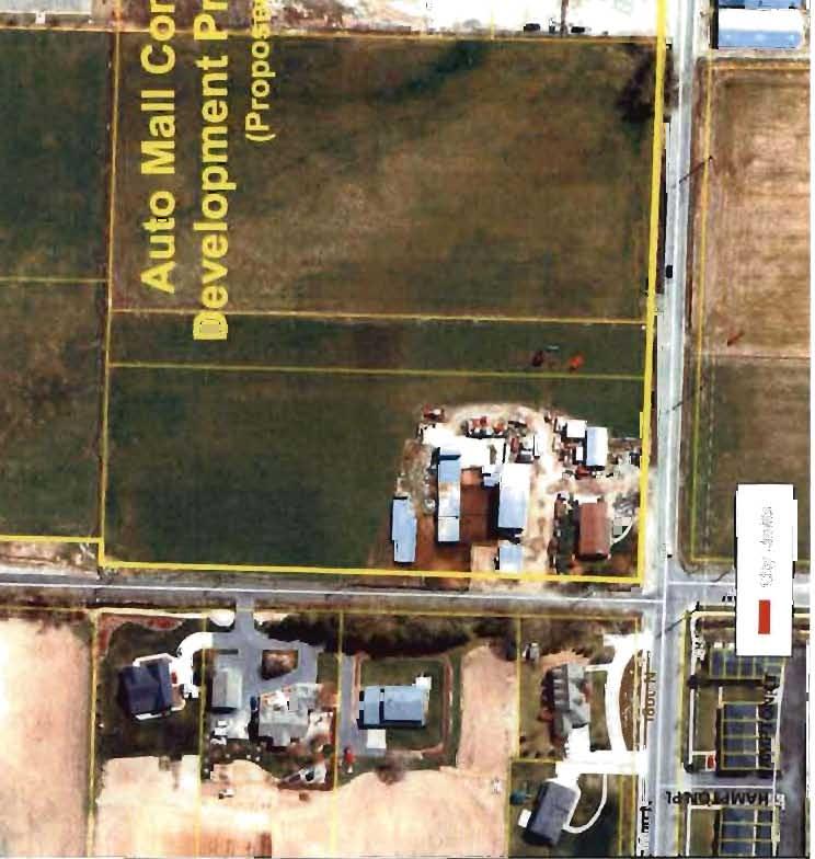
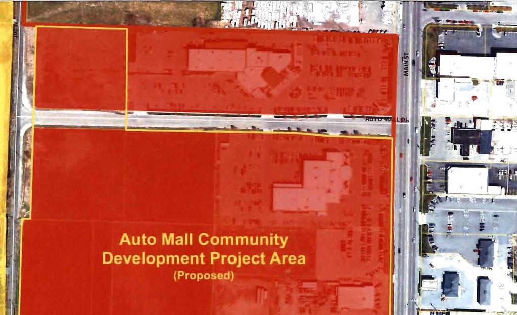
5 SECTION 1 DESCRIPTION OF BOUNDARIES AND MAP OF THE PROJECT AREA A map of the Project Area is attached hereto and incorporated herein as Exhibit"A". SECTION 2 GENERAL STATEMENT OF THE LAND USES, LAYOUT OF PRINCIPAL STREETS, POPULATION DENSITIES, BUILDING INTENSITIES AND HOW THEY WILL BE AFFECTED BY THE COMMUNITY DEVELOPMENT A. General Statement of Land Uses in the Project Area The permitted land uses within the Project Area shall be those uses permitted by the officially adopted zoning ordinances of the City, as those ordinances may be amended from time to time, subject to limitations imposed by "overlay" restrictions and the controls and guidelines ofthis Project Area Plan. A Land Use Map for the Project Area Plan is included as Exhibit "B" and is made a part of this Project Area Plan. The existing uses of the Project Area are: commercial...~agricu1tural and limited residential. It is expected that the currently permitted land uses in the Project Area may not be directly changed for purposes of effecting the redevelopment of the Project Area. However, the City may propose zoning ordinance amendments in order to aid in or promote redevelopment. It is expected that the current uses for the Project Area will be affected by redevelopment of the Project Area as follows: The upgrading of existing commercial facilities, an increase in commercial traffic with the construction of additional commercial and retail facilities, and a reduction in agricultural and residential uses. B. Layout of Principal Streets in the Project Area The layout of the principal streets in the Project Area is shown on the Project Area map attached as Exhibit "All and incorporated herein. It is not expected that RFedevelopment of the Project Area wth-may minimally affect the existing principal streets. C. Population Densities in the Project Area There are no unusual population densities found within the boundaries of the Project Area. It is not expected that population density will be affected by redevelopment of the Project Area except as follows: It is expected that as the area transitions to more commercial uses, the area's daytime business population will increase. D. Building Intensities in the Project Area No unusual evidence of building intensities is found in the Project Area. It is expected that the building intensities within the Project Area will be affected by redevelopment as follows: 3
6 Building intensities will increase as some of the vacant or under developed parcels are developed. A. Statement of Development Objectives l. Remove structurally substandard buildings or improvements to new construction and the return of the Project Area to a higher and more productive economic use. 2. Remove to land disposition and through of land into reasonably and shaped served by improved public utilities and infrastructure improvements. 3. Rehabilitate buildings sound CLu>rrn economic activity can be thereby. 4. Eliminate environmental including: irregular lot configurations, improper excessive of the land, potential hazards, underutilized 5. Achieve an environment reflecting a high level of concern for architectural, landscape and urban design principles, developed through encouragement, appropriate controls, and professional to owner and 6. and Project Area for development or redevelopment that would be complimentary to businesses and industries or would enhance the economic the community through diversification. 7. Provide utilities, curbs, sidewalks, street trees site to give area a new look to attract activity. 8. Provide for the strengthening tax base and economic health of entire of Utah. 9. Provide access management to the area to facilitate better circulation and reduce hazards. The shall work with the City to recommend ways to circulation and the Project Area. 10. Provide compatible among uses and quality standards for opment, that the area functions as a unified viable center social and activity City. 4
7 11. Promote more walking and less driving through new development areas, which allows greater opportunity to walk within the Project Area. Provide improved pedestrian circulation systems to allow greater pedestrian access from surrounding areas. 12. Coordinate and improve the public transportation system, including streets and public transit services. 13. Eliminate the blighting factors and blighting influences in the Project Area. 14. Promote cross-accesses between developments. B. General Design Objectives Subject to the development objectives and other provisions of this Plan, owners and developers will be allowed flexibility in the redevelopment of land located within the Project Area and are expected to obtain the highest quality design and development. Each redevelopment proposal will be considered subject to: (l) appropriate elements of the City's general plan; (2) the design and development standards of the City's land development code; (3) other applicable building codes and ordinances of the City; and (4) a review and recommendation by the appropriate decision-making body to ensure that the redevelopment is consistent with this Project Area Plan. Each redevelopment proposal by an owner or a developer will be accompanied by site plans, development data and other appropriate material that clearly describes the extent of redevelopment proposed, including land coverage, setbacks, landscaping, building heights, bulk and designs, off-street parking and loading areas, use of public transportation, and any other data determined to be necessary or requested by the City or the Agency. The general design of specific projects may be developed or approved by the Agency in cooperation with the appropriate decision-making body. The particular elements of the design should be such that the overall redevelopment of the Project Area will: I. Provide an attractive urban environment; 2. Blend harmoniously with the adjoining areas; 3. Provide for the optimum amount of open space and landscape in relation to new buildings; 4. Provide parking areas, appropriately screened and/or landscaped to blend harmoniously with the area; 5. Provide pedestrian areas that safely link buildings with parking areas and neighboring public streets; 6. Provide adequate off-street parking to service the proposed development; 5
8 7. Promote improved transportation and circulation options including the use of mass transit; and 8. Comply with the provisions of this Plan. Specific Design Objectives Controls 1. Building Design Objectives: a. All new buildings shall be utilizing a wide range of elements are in with the areas, other new development with the land development code. New buildings and exemplary ofthe design standards. The design buildings shall optimum advantage of available views and topography. c. Buildings within Project Area shall designed and placed to act as significant landmarks in Project Area and 2. Open Space Walks Objectives: a. open spaces, interior drives be tree lined designed as an integral part of an overall site properly related to existing and proposed buildings, area topography, access and circulation needs, etc. b. Attractively landscaped open spaces shall provided, which will offer maximum to occupants building which they are developed. streets, pedestrian buildings on shall connect building entrances to from vehicular ~',"," of pedestrian walks shall afford maximum safety separation e. Materials design of retaining walls, curbs, and other accoutrements, shall be ofgood appearance, maintained, purpose. space areas. installed to conserve the use of water of 3. Design Objectives: 6
9 a. Parking areas be part of the the site with careful regard to orderly ease of access. b. Parking areas shall adequately landscaped to provide shade and to large of paved areas. c. Large parking and service areas adjacent to public streets shall landscaped as the land development 4. Landscape Design a. coordinated landscaped incorporating a continuous and treatment for space, roads, paths, parking areas shall be a primary b. Primary landscape treatment shall consist a variety of materials as appropriate to character the Project and as determined by 5. Project Improvement Objectives: a. Public rights-of-way. All sidewalks parks trips within public rights-of-way shall be approved the City and shall be consistent with minimum City right of way cross section requirements consistent with the shall be sky and all ronint''''''' the source light from streets. land development code. c. Grading. applicable portions of Project will be in conformance with the final project determined by the and the for each project. Stormwater. All developed areas will provide stormwater improvements consistent with city storm water and standards. e. Natural and amenities as rivers, topographic features, or wetlands shall be integrated into PLAN remove, if with assistance and participation private owners, to blighting influences from the Project Area by the methods 7
10 described in this Project Area Plan. Such methods may renovation or rehabilitation of blighted buildings, structures, or U'",, rn clearance of land or the rehabilitation of buildings and encouraged to undertake new development or redevelopment which ofthe community in furtherance ofthe objectives set forth in SECTION 5 This Project Area Plan is consistent with and General Plan in the following to Zoning Ordinances nr "",,,,rtu within the Project Area is currently zoned Commercial (COM). rodose:u development is permitted under the current are required, such changes would B. Building Codes The construction of all new buildings and improvements, existing buildings or improvements, will be done in accordance with the standards set forth in the general plan of the City and in accordance with the International Building by the City. All building permits for construction or rehabilitation will be issued by compliance with minimum City development standards. The Agency believes on the basis ofcurrent proposals the Project Area that a number of redevelopment projects may to accomplish the purposes ofthis Project Area Plan. which the Agency believes are possible is the development related businesses. SECTION 7 WAYS IN WHICH PRIVATE DEVELOPERS, IF ANY, WILL BE SELECTED TO UNDERTAKE THE COMMUNITY DEVELOPMENT AND PRIVATE DEVELOPERS CURRENTLY INVOLVED A. Selection of Private Developers previously adopted Owner Participation which Guidelines permit owners property, or tenants of real property, a preference in undertaking r...lll,..'i... Project Area. Agency contemplates that owners of real property within take advantage ofthe opportunity to develop their property. In the event that owners do not 8
11 to participate in the redevelopment in compliance with the Plan, or in a manner acceptable to the Agency, or are unable or unwilling to appropriately participate, the Agency reserves the right pursuant to the provisions of the Act to acquire parcels, to encourage other owners to acquire other property within the Project Area, or to select non~owner developers by private negotiation, public advertisement, bidding or the solicitation of written proposals, or a combination of one or more of the above methods, and by doing so to encourage or accomplish the desired redevelopment of the Project Area. B. Identification of Developers who are Currently Involved in the Proposed Community Development The Agency has been contacted by or has been in contact with some of the current property owners within the Project Area. Some property owners have expressed an interest to participate or become a developer of part of the Project Area, but no project submittals or proposals have been made by said property owners. 1. Qualified Owners The Agency shall first permit qualified owners within the Project Area to participate as developers in the redevelopment of the Project Area. 2. Other Parties Regarding all or any portion of the Project Area, if owners in the Project Area, as described in Subparagraph A above, do not propose redevelopment projects acceptable to the Agency, or do not possesses the necessary skill, experience and financial resources, or are not willing or able to appropriately redevelop all or part of the Project Area, the Agency may identify other qualified persons who may be interested in developing all or part of the Project Area. Potential developers may be identified by one or more of the following processes: (l) public solicitation, (2) requests for proposals (RFP), (3) requests for bids (RFB), (4) private negotiation, or (5) some other method of identification approved by the Agency. 3. Owner Participation Agreements The Agency has not entered into nor does it intend to enter into any owner participation agreements or agreements with developers to develop all or part of the Project Area until after the Agency and the City decide whether or not to adopt this Project Area Plan for the Project Area. SECTION 8 THE REASONS FOR THE SELECTION OF THE PROJECT AREA The Project Area was selected by the Agency as that area within the City having an immediate opportunity to strengthen the economic base of the community through one or more new projects which would develop the area in an appropriate manner and broaden the tax base of the community. The Project Area contains a portion of the City that is desirable for 9
12 redevelopment because of: (1) a general recognition by the owners and the public that the Project Area is under developed and needs assistance if the area is to reach its development potential; (2) a recognition and growing support by property owners that this portion of the City needs the reinvestment of private capital to rehabilitate existing buildings or construct new buildings or infrastructure improvements; and (3) the opportunity to commence a public-private partnershi p to improve this area of the Ci ty. Specific boundaries of the Project Area were arrived at by the Agency after a review of the area by members of the Agency, City staff, including legal staff, redevelopment consultants, -and input from property owners. Planned treatment of this area is intended to stimulate development to the degree necessary for sound long-range economic growth in the Project Area and to encourage the further development of real property located within the Project Area. SECTION 9 THE DESCRIPTION OF THE PHYSICAL, SOCIAL, AND ECONOMIC CONDITIONS EXISTING IN THE PROJECT AREA A. Physical Conditions The Project Area consists of approximately 2-S-~acres of privately owned land as shown on the Project Area portion of the Project Area map. The physical characteristics of the Project Area may generally be classified as that area of the City which is located west of Main Street and east of200 West, between Auto Mall Drive (1950 North) and 1800 North, in addition to one parcel lying north of Auto Mall Drive (1950 North) and adjacent to 200 West, consisting of an area of mixed commercial uses and vacant land, suffering from under development or no development. B. Social Conditions There are currently approximately five (5) businesses in the Project Area. No unusual social conditions are found to exist. Because of the land uses in the Project Area and consistent with the General Plan of the City, it is unlikely that any new residential land uses will be permitted within the Project Area. C. Economic Conditions The Project Area is currently zoned Commercial (COM). SECTION 10 A DESCRIPTION OF ANY TAX INCENTIVES OFFERED TO PRIVATE ENTITIES FOR FACILITIES LOCATED IN THE PROJECT AREA The following generally describes tax or other incentives which the Agency intends to offer within the Project Area to developers in consideration for constructing and operating the proposed development. The Agency may offer other incentives and use tax increment in other ways, as authorized and provided for in the Act. 10
13 The Agency intends to use tax increment from the Project Area, subject to Agency discretion and only to the extent tax increment funds are available, to help pay for the costs associated with the development of the Project Area (the "Reimbursed Costs"). Reimbursed Costs may include costs for such items as public infrastructure improvements, Agency requested off-site improvements and upgrades and on-site upgrades, land write downs, desirable Project Area improvements and other items as approved by the Agency. Payment to the City or developer for Reimbursed Costs shall be made through an agreement between the Agency and the City or the Agency and the developer. Except where the Agency issues bonds or otherwise borrows or receive funds, the Agency expects to pay the City or developer for the agreed upon Reimbursed Costs in tax increment payments to be paid after receipt by the Agency of the tax increment after ad valorem taxes have been paid to the County and then distributed to the Agency. The tax increment for making payments will be received as a result of the incremental ad valorem tax increases on the Project Area due to the development in the Project Area. Subject to the provisions ofthe Act, the Agency may agree to pay Reimbursed Costs and other items from tax increment for any period of time that the Agency may deem to be appropriate under the circumstances. SECTION 11 DESCRIPTION OF ANTICIPATED PUBLIC BENEFIT TO BE DERIVED FROM THE REDEVELOPMENT It is anticipated that the public benefit to be derived from the proposed development in the Project Area will include the following: 1. Beneficial Influences upon the Tax Base of the Community The following benefits are projected to accrue to the tax base of the community and/or the state as a result of the subject redevelopment: (1) real property tax revenue; (2) personal property tax revenue; (3) local option sales tax revenue; (4) personal income and corporate franchise tax revenue. As a result of the redevelopment in the Project Area, by the year 2030, the annual property tax alone is expected to increase by somewhere in the range of $4Q.5,000 over and above the 2013 $88,582 property tax amount. 2. Jobs or Employment Anticipated As A Result of the Redevelopment It is anticipated that the proposed redevelopment will result in a number of new jobs or full time positions. With the location of the City in relation to neighboring cities, the Agency believes that some of the work force relating to the proposed redevelopment will likely come from other areas ofthe County. Some employees obtaining employment in the Project Area may wish to relocate to the City due to the quality of life near their job location. Other potential employees may wish to lower expenses by living close to work in an affordable locale. The proposed development should help provide jobs for any anticipated growth in population. 3. Associated Business and Economic Activity Likely to Be Stimulated By the Redevelopment
14 refer to infonnation set forth Also, direct and indirect benefits will accrue to various businesses products or are currently underutilized, will be ne(~de'd by constructing or operating commercial businesses in area. Benefits are expected to accrue to such as food services, specialty and services. associated construction and operations within the new development will the construction and maintenance and suppliers in area. SECTION 12


15 -IV,, ~.~tt~..r.i' '!&\i.~ I
16 Auto Mall Community Development Project Area AN AREA OF LAND SITUATED IN THE EAST HALF OF SECTION 21, TOWNSHIP 12 NORTH, RANGE 1 SALT LAKE BASE AND MERIDIAN. MORE PARTICULARLY DESCRIBED AS FOLLOWS: BEGINNING AT THE NORTHWEST CORNER OF LOT 4 OF THE AUTO MALL SUBDIVISION, SAID POINT BEING NORTH EAST FEET FROM THE LOGAN CITY GIS/GPS MONUMENT NUMBER 338 (BASIS OF BEARING BEING NORTH 51"33'13" EAST BETWEEN LOGAN CITY GIS/GPS MONUMENTS 290 AND 338). RUNNING THENCE ALONG THE EAST RIGHT OF WAY LINE OF 200 WEST THE FOLLOWING THREE COURSES: SOUTH 01 58'OS" WEST FEET TO THE SOUTHWEST CORNER OF LOT 3 OF THE AUTO MALL SUBDIVISION; THENCE, NORTH 88 24'09" WEST FEET; THENCE SOUTH 01 31'35" WEST FEET TO THE INTERSECTION OF THE EAST RIGHT OF WAY LINE OF 200 WEST AND THE NORTH RIGHT OF WAY LINE OF 1800 NORTH; THENCE SOUTH 88 11'24" EAST 1, FEET ALONG SAID NORTH RIGHT OF WAY LINE OF 1800 NORTH, TO THE SOUTHWEST CORNER OF LOT 3 OF THE U.D.O.T. PROPERTY KNOWN AS CACHE COUNTY PARCEL NUMBER ; NORTH 45 50'11" EAST FEET ALONG THE SOUTHEAST PROPERTY LINE OF SAID PARCEL , TO THE WEST RIGHT OF WAY LINE OF STATE ROUTE 91, ALSO KNOWN AS MAIN STREET; THENCE ALONG SAID RIGHT OF WAY LINE THE FOLLOWING THREE NORTH 01"07'14" EAST FEET; NORTH 88 24'09" WEST 5.14 THENCE, NORTH 01 04'33" EAST FEET, TO THE SOUTH RIGHT OF WAY LINE OF AUTO MALL DRIVE (1950 NORTH); THENCE ALONG SAID SOUTH RIGHT OF WAY LINE THE FOLLOWING FOUR COURSES, NORTH 43"39'48" WEST FEET; NORTH 88 24'09" WEST THENCE, NORTH 84"35'27" WEST FEET; THENCE, NORTH 88"24'09" WEST FEET, TO THE INTERSECTION OF THE SAID SOUTH RIGHT OF WAY LINE AND THE EXTENSION OF THE EAST LINE OF LOT 4 OF THE AUTO MALL SUBDIVISION; THENCE, NORTH 01"52'18" EAST ALONG SAID EAST line OF LOT 4 AND ITS EXTENSION, TO THE NORTHEAST CORNER OF SAID LOT 4; NORTH 88"07'16" WEST ALONG THE NORTH LOT LINE OF SAID LOT 4, TO THE POII\IT OF BEGINNING. CONTAINING 1,321, SQUARE FEET OR ACRES MORE OR LESS


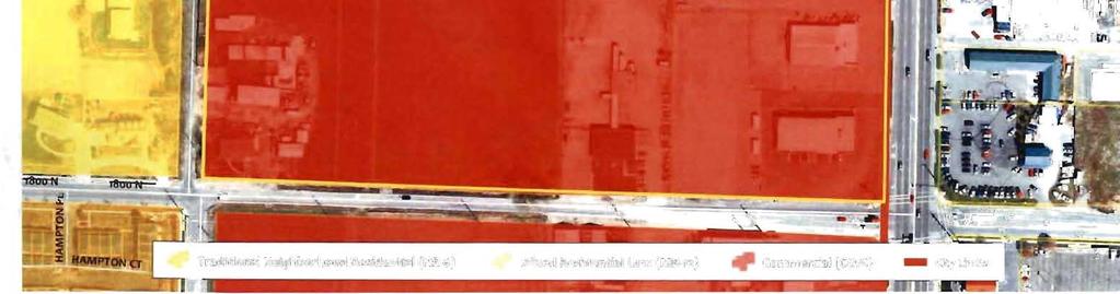
17 i'. ~'* r " cc +J - -..c..c >< LLI Traditional Neighborhood Residential (NR-6) Mixed Residential Low (MR-12) Commercial (COM)
COMMUNITY INVESTMENT FRAMEWORK Adams Investment Area
 COMMUNITY INVESTMENT FRAMEWORK Adams Investment Area Ogden City Redevelopment Agency March 9, 2017 TABLE OF CONTENTS General Statement 1 Section 1 - Definition and Map of Investment Area 1 Section 2 -
DRAFT PROJECT AREA PLAN UNIVERSITY PLACE COMMUNITY DEVELOPMENT AREA (CDA) OREM REDEVELOPMENT AGENCY, UTAH
 OREM REDEVELOPMENT AGENCY, UTAH") UNIVERSITY PLACE COMMUNITY DEVELOPMENT AREA (CDA) OREM REDEVELOPMENT AGENCY, UTAH Table of Contents TABLE OF CONTENTS... 2 INTRODUCTION... 3 DEFINITIONS... 4 DESCRIPTION OF THE BOUNDARIES OF THE PROPOSED
UNIVERSITY PLACE COMMUNITY DEVELOPMENT AREA (CDA) OREM REDEVELOPMENT AGENCY, UTAH Table of Contents TABLE OF CONTENTS... 2 INTRODUCTION... 3 DEFINITIONS... 4 DESCRIPTION OF THE BOUNDARIES OF THE PROPOSED
FILLMORE COMMUNITY REINVESTMENT AREA (CRA)
") DRAFT PROJECT AREA PLAN FILLMORE COMMUNITY REINVESTMENT AREA (CRA) REDEVELOPMENT AGENCY OF FILLMORE CITY, UTAH FEBRUARY 2018 Table of Contents DEFINITIONS... 3 INTRODUCTION... 5 DESCRIPTION OF THE BOUNDARIES
DRAFT PROJECT AREA PLAN FILLMORE COMMUNITY REINVESTMENT AREA (CRA) REDEVELOPMENT AGENCY OF FILLMORE CITY, UTAH FEBRUARY 2018 Table of Contents DEFINITIONS... 3 INTRODUCTION... 5 DESCRIPTION OF THE BOUNDARIES
AGENDA. A. CALL TO ORDER 1:00 PM B. PLEDGE OF ALLEGIANCE C. DISCLOSURES D. APPROVAL OF THE MINUTES: October 13, 2015 Town Council Meeting
 The Regular Meeting of the Brian Head Town Council acting as the Governing Body of the Brian Head Redevelopment Agency Town Hall - 56 North Highway 143 Brian Head, UT 84719 TUESDAY, OCTOBER 27, 2015 @
DRAFT PROJECT AREA PLAN 700 WEST COMMUNITY DEVELOPMENT AREA (CDA) REDEVELOPMENT AGENCY OF RIVERDALE CITY, UTAH
 REDEVELOPMENT AGENCY OF RIVERDALE CITY, UTAH") DRAFT PROJECT AREA PLAN 700 WEST COMMUNITY DEVELOPMENT AREA (CDA) REDEVELOPMENT AGENCY OF RIVERDALE CITY, UTAH JULY 2016 Table of Contents TABLE OF CONTENTS... 2 DEFINITIONS... 3 INTRODUCTION... 5 DESCRIPTION
DRAFT PROJECT AREA PLAN 700 WEST COMMUNITY DEVELOPMENT AREA (CDA) REDEVELOPMENT AGENCY OF RIVERDALE CITY, UTAH JULY 2016 Table of Contents TABLE OF CONTENTS... 2 DEFINITIONS... 3 INTRODUCTION... 5 DESCRIPTION
ARTICLE 14 PLANNED UNIT DEVELOPMENT (PUD) DISTRICT
 DISTRICT") ARTICLE 14 PLANNED UNIT DEVELOPMENT (PUD) DISTRICT Section 14.01 Intent. It is the intent of this Article to allow the use of the planned unit development (PUD) process, as authorized by the Michigan Zoning
ARTICLE 14 PLANNED UNIT DEVELOPMENT (PUD) DISTRICT Section 14.01 Intent. It is the intent of this Article to allow the use of the planned unit development (PUD) process, as authorized by the Michigan Zoning
UPPER MOUNT BETHEL TOWNSHIP NORTHAMPTON COUNTY, PENNSYLVANIA
 UPPER MOUNT BETHEL TOWNSHIP NORTHAMPTON COUNTY, PENNSYLVANIA JOINDER DEED / LOT CONSOLIDATION TOWNSHIP REVIEW PROCESS When accepting proposed Joinder Deeds / Lot Consolidations, review the Joinder Deed
for the Logan Golf and Country Club; and
 CITY OF LOGAN ORDINANCE NO. 16-01 AN ORDINANCE VACATING PUBLIC RIGHTS-OF-WAY INCLUDING 700 NORTH AND 900 NORTH FROM 1600 EAST TO THE EASTERN CITY BOUNDARY, 2000 EAST FROM 700 NORTH TO 900 NORTH AND A BROAD
PLANNED UNIT DEVELOPMENTS (Ordinance No.: 3036, 12/3/07; Repealed & Replaced by Ordinance No.: 4166, 10/15/12)
") 159.62 PLANNED UNIT DEVELOPMENTS (Ordinance No.: 3036, 12/3/07; Repealed & Replaced by Ordinance No.: 4166, 10/15/12) A. PURPOSE 1. General. The Planned Unit Development (PUD) approach provides the flexibility
159.62 PLANNED UNIT DEVELOPMENTS (Ordinance No.: 3036, 12/3/07; Repealed & Replaced by Ordinance No.: 4166, 10/15/12) A. PURPOSE 1. General. The Planned Unit Development (PUD) approach provides the flexibility
WHEREAS, are existing rights-of-way that extend through Utah State University property that are used the Golf Country Club; and
 CITY Of LOGAN ORDINANCE NO. 16-01 AN ORDINANCE VACATING PUBLIC RIGHTS-Of-WAY INCLUDING 100 NORTH AND 900 NORTH from 1600 EAST TO THE EASTERN CITY BOUNDARY, 2000 EAST from 100 NORTH TO 900 NORTH AND A BROAD
TITLE 7. MUNICIPAL IMPROVEMENTS AND PUBLIC SERVICE PROJECTS
 MUNICIPAL IMPROVEMENTS AND PUBLIC SERVICE PROJECTS 7-1 TITLE 7. MUNICIPAL IMPROVEMENTS AND PUBLIC SERVICE PROJECTS CHAPTER 7-100. FREEWAY INTER- CHANGE DEVELOPMENT PLAN - REPORT. This report on the project
Magna Commerce Park COMMUNITY DEVELOPMENT AREA PROJECT PLAN. May 24, 2016
 Magna Commerce Park COMMUNITY DEVELOPMENT AREA PROJECT PLAN May 24, 2016 By: GSBS Consulting REDEVELOPMENT AGENCY OF SALT LAKE COUNTY TABLE OF CONTENTS 1. Introduction & Overview 1 2. Recitals of Preconditions
In order to permit maximum applicability of the PUD District, PUD-1 and PUD-2 Districts are hereby created.
 ARTICLE III. PUD ned Unit Development Overlay District 205-128. Purpose. The PUD ned Unit Development Overlay District is intended to provide flexibility in the design of planned projects; to encourage
ARTICLE 15 - PLANNED UNIT DEVELOPMENT
 Section 15.1 - Intent. ARTICLE 15 - PLANNED UNIT DEVELOPMENT A PUD, or Planned Unit Development, is not a District per se, but rather a set of standards that may be applied to a development type. The Planned
PLANNED UNIT DEVELOPMENT (PUD)
") SECTION 38.01. ARTICLE 38 PLANNED UNIT DEVELOPMENT (PUD) Purpose The purpose of this Article is to implement the provisions of the Michigan Zoning Enabling Act, Public Act 110 of 2006, as amended, authorizing
SECTION 38.01. ARTICLE 38 PLANNED UNIT DEVELOPMENT (PUD) Purpose The purpose of this Article is to implement the provisions of the Michigan Zoning Enabling Act, Public Act 110 of 2006, as amended, authorizing
ORDINANCE NO
 ORDINANCE NO. 2014-160 AN ORDINANCE OF THE CITY COUNCIL OF THE CITY OF MENIFEE, CALIFORNIA, REPEALING SECTION 10.35 OF RIVERSIDE COUNTY LAND USE ORDINANCE NO. 460.152 AS ADOPTED BY THE CITY OF MENIFEE
Hennepin County Department of. Housing, Community Works and Transit. Transit Oriented Development (TOD) Guidelines
 Guidelines") Hennepin County Department of Housing, Community Works and Transit 2007 Transit Oriented Development (TOD) Guidelines Hennepin County Transit Oriented Development (TOD) Bond Funds Hennepin County Housing,
Hennepin County Department of Housing, Community Works and Transit 2007 Transit Oriented Development (TOD) Guidelines Hennepin County Transit Oriented Development (TOD) Bond Funds Hennepin County Housing,
Village of Port Jefferson Urban Renewal Plan
 Urban Renewal Plan Village of Port Jefferson Urban Renewal Plan Port Jefferson, New York PREPARED FOR Village of Port Jefferson Village Board 121 West Broadway Port Jefferson, NY 11777 631.473.4724 PREPARED
PLANNING COMMISSION STAFF REPORT
 PLANNING COMMISSION STAFF REPORT West Capitol Hill Zoning Map Amendment Petition No. PLNPCM2011-00665 Located approximately at 548 W 300 North Street, 543 W 400 North Street, and 375 N 500 West Street
CITY OF SAN LEANDRO SUCCESSOR AGENCY OVERSIGHT BOARD. Cynthia Battenberg, Business Development Manager
 STAFF REPORT CITY OF SAN LEANDRO SUCCESSOR AGENCY OVERSIGHT BOARD DATE: September 25, 2012 TO: FROM: SUBJECT: Successor Agency Oversight Board Cynthia Battenberg, Business Development Manager Oversight
CHAPTER 10 Planned Unit Development Zoning Districts
 CHAPTER 10 Planned Unit Development Zoning Districts Section 10.1 Intent and Purpose The Planned Unit Development (PUD) districts are intended to offer design flexibility for projects that further the
Redevelopment Project Plan and Eligibility Report for the: Cook County Project Area. Village of East Dundee, Illinois. Draft: July 18, 2012
 for the: Cook County Project Area Village of East Dundee, Illinois Draft: Created By: Vandewalle & Associates 2012 Table of Contents TABLE OF CONTENTS Table of Contents... i Executive Summary... 1 Part
COUNCIL COMMUNICATION
 Meeting Date: October 24, 2017 COUNCIL COMMUNICATION Agenda Item: Agenda Location: Public Hearings Work Plan # Legal Review: X 1 st Reading 2 nd Reading Subject: A public hearing regarding Zoning and a
ACTION FORM BRYAN CITY COUNCIL
 ACTION FORM BRYAN CITY COUNCIL DATE OF COUNCIL MEETING: July 8, 2014 DATE SUBMITTED: June 17, 2014 DEPARTMENT OF ORIGIN: Development Services SUBMITTED BY: Maggie Dalton MEETING TYPE: CLASSIFICATION: ORDINANCE:
CITY OF ELK GROVE CITY COUNCIL STAFF REPORT
 AGENDA ITEM NO. 9.2 CITY OF ELK GROVE CITY COUNCIL STAFF REPORT AGENDA TITLE: A public hearing to consider a Specific Plan Amendment to the Laguna Ridge Specific Plan and a Rezone of approximately 4.14
PLANNED UNIT DEVELOPMENT & SUBDIVISION STAFF REPORT Date: April 18, 2019
 PLANNED UNIT DEVELOPMENT & SUBDIVISION STAFF REPORT Date: April 18, 2019 DEVELOPMENT NAME SUBDIVISION NAME Springhill Village Subdivision Springhill Village Subdivision LOCATION 4350, 4354, 4356, 4358,
ZONING ORDINANCE: OPEN SPACE COMMUNITY. Hamburg Township, MI
 ZONING ORDINANCE: OPEN SPACE COMMUNITY Hamburg Township, MI ARTICLE 14.00 OPEN SPACE COMMUNITY (Adopted 1/16/92) Section 14.1. Intent It is the intent of this Article to offer an alternative to traditional
Chapter SPECIAL USE ZONING DISTRICTS
 Chapter 20.20 Sections: 20.20.010 Urban Transition (U-T) Zoning District 20.20.020 Planned Development (P-D) Zoning Districts 20.20.010 Urban Transition (U-T) Zoning District A. Purpose. The purpose of
EVALUATION AND APPRAISAL REPORT OF THE CITY OF FELLSMERE COMPREHENSIVE PLAN APPENDIX D HOUSING ELEMENT
 OBJECTIVE H-A-1: ALLOW AFFORDABLE HOUSING AND ADEQUATE SITES FOR VERY LOW, LOW, AND MODERATE INCOME HOUSING. The City projects the total need for very low, low, and moderate income-housing units for the
OWNERS, BUSINESSES AND TENANTS PARTICIPATION AND RE-ENTRY RULES
 OWNERS, BUSINESSES AND TENANTS PARTICIPATION AND RE-ENTRY RULES Prepared For The CALIMESA REDEVELOPMENT PROJECT NO. 2 THE CALIMESA REDEVELOPMENT AGENCY July 2010 OWNERS, BUSINESSES AND TENANTS PARTICIPATION
ORDINANCE WHEREAS, the adoption of this Ordinance shall not be construed as an admission that the aforesaid claim has merit or is correct; and
 ORDINANCE 12-24 AN ORDINANCE OF THE CITY OF WINTER GARDEN, FLORIDA, REPEALING ORDINANCE 12-02 AND REPLACING IT WITH THE AMENDMENTS TO ARTICLE V OF CHAPTER 118 OF THE WINTER GARDEN CODE OF ORDINANCES CONTAINED
REDEVELOPMENT ADVISORY COMMITTEE RECOMMENDATION:
 DATE: September 15, 2011 ITEM: RE: 7.C. CONSIDERATION AND ADOPTION OF A RESOLUTION OF THE BOARD OF DIRECTORS OF THE REDEVELOPMENT AGENCY OF SALT LAKE CITY APPROVING THE REQUEST FOR PROPOSALS TERM SHEET
Salem Township Zoning Ordinance Page 50-1 ARTICLE 50.0: PUD PLANNED UNIT DEVELOPMENT
 Salem Township Zoning Ordinance Page 50-1 ARTICLE 50.0 PLANNED UNIT DEVELOPMENT Section 50.01 Purpose The provisions of this Article provide enabling authority and standards for the submission, review,
CONDOMINIUM REGULATIONS
 ARTICLE 37 CONDOMINIUM REGULATIONS SECTION 37.01. Purpose The purpose of this Article is to regulate projects that divide real property under a contractual arrangement known as a condominium. New and conversion
Glendale Housing Development Project Plan
 Glendale Housing Development Project Plan Draft for Public Review May 29, 2015 Table of Contents I. Introduction... 1 II. Description of Project... 1 A. Boundary of Housing Development Project... 1 B.
MINNETONKA PLANNING COMMISSION June 2, A conditional use permit for 2,328 square feet of accessory structures at 4915 Highland Road
 MINNETONKA PLANNING COMMISSION June 2, 2016 Brief Description A conditional use permit for 2,328 square feet of accessory structures at Recommendation Recommend the city council adopt the resolution approving
5.03 Type III (Quasi-Judicial) Decisions
 Decisions") 5.03 Type III (Quasi-Judicial) Decisions 5.03 General Requirements A. The purpose of this Section is to identify what types of actions are considered Type III decisions. Type III decisions involve significant
5.03 Type III (Quasi-Judicial) Decisions 5.03 General Requirements A. The purpose of this Section is to identify what types of actions are considered Type III decisions. Type III decisions involve significant
CITY OF NAPLES STAFF REPORT
 Meeting of 05/13/15 Conditional Use Petition 15-CU3 CITY OF NAPLES STAFF REPORT To: Planning Advisory Board From: Planning Department Subject: Conditional Use Petition 15-CU3 Petitioner: Hazelden Betty
COOPERATIVE AGREEMENT BETWEEN THE REDEVELOPMENT AGENCY OF THE CITY OF RIO VISTA AND THE CITY OF RIO VISTA
 COOPERATIVE AGREEMENT BETWEEN THE REDEVELOPMENT AGENCY OF THE CITY OF RIO VISTA AND THE CITY OF RIO VISTA This Cooperative Agreement (this Agreement ) is entered into effective as of March 17, 2011 ( Effective
Staff Report. Victoria Walker, Director of Community and Economic Development
 10.c Staff Report Date: April 25, 2017 To: From: Reviewed by: Prepared by: Subject: City Council Valerie J. Barone, City Manager Victoria Walker, Director of Community and Economic Development John Montagh,
EXCERPT Planned Residential Development (PRD)
") LAND DEVELOPMENT CODE ESTABLISHING ZONING DISTRICTS AND REGULATIONS FOR LAND DEVELOPMENT AND SUBDIVISION IN THE CITY OF HATTIESBURG, MISSISSIPPI ORDINANCE NO. 2330 ADOPTED DECEMBER 05, 1989 EXCERPT Planned
LAND DEVELOPMENT CODE ESTABLISHING ZONING DISTRICTS AND REGULATIONS FOR LAND DEVELOPMENT AND SUBDIVISION IN THE CITY OF HATTIESBURG, MISSISSIPPI ORDINANCE NO. 2330 ADOPTED DECEMBER 05, 1989 EXCERPT Planned
Downtown Meridian Urban Renewal Area URBAN RENEWAL ELIGIBILITY REPORT. Prepared for The City of Meridian and The Meridian Development Corporation
 Downtown Meridian Urban Renewal Area URBAN RENEWAL ELIGIBILITY REPORT Prepared for The City of Meridian and The Meridian Development Corporation by McKibben + Cooper Architects June 19, 2002 Authorization
STAFF REPORT. Director Planning, Zoning and Building Department. Longboat Key, Florida
 STAFF REPORT DATE: October 12, 2015 TO: FROM: THROUGH: Planning and Zoning Board Maika Arnold, Planner Planning, Zoning and Building Department Alaina Ray, AICP Director Planning, Zoning and Building Department
ARTICLE 9 SPECIFICATIONS FOR DOCUMENTS TO BE SUBMITTED
 ARTICLE 9 SPECIFICATIONS FOR DOCUMENTS TO BE SUBMITTED SECTION 950 GENERALLY All applications shall be properly signed and filed by the owner or, with the owner s specific written consent, a contract purchaser
Development Plan. For. Butchertown Stadium District Development Area. Louisville/Jefferson County Metro Government, 2017
 Development Plan For Butchertown Stadium District Development Area Louisville/Jefferson County Metro Government, 2017 Development Plan The Butchertown Stadium District Development Area 1. Introduction.
7. IMPLEMENTATION STRATEGIES
 7. IMPLEMENTATION STRATEGIES A. GENERAL APPROACH FOR IMPLEMENTATION Implementing the plan will engage many players, including the Municipality of Anchorage (MOA), the Government Hill Community Council,
OFFICIAL PROJECT AREA PLAN
 LYRB OFFICIAL PROJECT AREA PLAN BARNARD CREEK COMMUNITY DEVELOPMENT AREA (CDA) CENTERVILLE CITY REDEVELOPMENT AGENCY, UTAH ADOPTED: JULY 16, 2013 PREPARED BY: LEWIS YOUNG ROBERTSON & BURNINGHAM, INC. TABLE
Rule 80. Preservation of Primary Agricultural Soils Revised and approved by the Land Use Panel during its public meeting on January 31, 2006.
 Rule 80. Preservation of Primary Agricultural Soils Revised and approved by the Land Use Panel during its public meeting on January 31, 2006. (A) Purpose. In accordance with 10 V.S.A. Sections 6025(b)
Understanding Texas TIRZ Statute Chapter 311 Texas Tax Code
 CDFA/TEDC TIRZ SEMINAR Understanding Texas TIRZ Statute Chapter 311 Texas Tax Code Clark Stockton Lord Constitutional Authority The legislature by general law may authorize an incorporated city or town
Saskatchewan Municipal Financing Tools
 Saskatchewan Municipal Financing Tools The following is a list of financing tools currently available to Saskatchewan municipalities. Authority for a municipality to use any of these tools is provided
Jacobs Landing Rehabilitation Plan
 Jacobs Landing Rehabilitation Plan Township of Woodbridge Prepared by: Township of Woodbridge Department of Planning & Development June 2015 ADOPTED by Township of Woodbridge Planning Board ADOPTED by
Infill Development Incentive Policy
 Infill Development Incentive Policy PURPOSE It is the policy of the City of El Paso to provide incentives to promote infill development, reduce sprawl, increase the availability of attainable housing and
Medical Marijuana Special Exception Use Information
 Medical Marijuana Special Exception Use Information The Special Exception Use information below is a modified version of the Unified Development Code. It clarifies the current section 5:104 Special Exceptions
City of Philadelphia POLICIES FOR THE SALE AND REUSE OF CITY OWNED PROPERTY. Approved By Philadelphia City Council on December 11, 2014
 City of Philadelphia POLICIES FOR THE SALE AND REUSE OF CITY OWNED PROPERTY Approved By Philadelphia City Council on December 11, 2014 City of Philadelphia Disposition Policies December 2014 1 Table of
Staff Report: Date: Applicant: Property Identification: Acreage of Request: Current Zoning of Requested Area: Requested Action: Attached:
 Staff Report: Completed by Jeff Palmer Director of Planning & Zoning Date: November 7, 2018 Applicant: Greg Smith, Oberer Land Developer agent for Ronald Montgomery ET AL Property Identification: Frontage
CHAPTER34 PRUD - PLANNED RESIDENTIAL UNIT DEVELOPMENT
 CHAPTER34 PRUD - PLANNED RESIDENTIAL UNIT DEVELOPMENT 17-34-1 17-34-2 17-34-3 17-34-4 17-34-5 17-34-6 17-34-7 17-34-8 17-34-9 Purpose Planned Residential Unit Development Defined Planned Residential Unit
CHAPTER 22 SUBDIVISION AND LAND DEVELOPMENT
 CHAPTER 22 SUBDIVISION AND LAND DEVELOPMENT 22-101. Title 22-102. Legislative Intent Part 1 General Provisions 22-201. Development Permits Part 2 Administration 22-301. Fee Schedule Part 3 Fee Schedule
Special Exception Use Order Application
 Development Services Department Planning Division CITY OF OVIEDO 400 Alexandria Boulevard Oviedo, Florida 32765 Application No. Date Received Pre-application Meeting Date Phone: (407) 971-5775 (407)971-5819
CHAPTER XVIII SITE PLAN REVIEW
 CHAPTER XVIII SITE PLAN REVIEW Section 18.1 Section 18.2 Description and Purpose. The purpose of this chapter is to provide standards and procedures under which applicants would submit, and the Township
THE REDEVELOPMENT PLAN
 PAGE 37 THE REDEVELOPMENT PLAN FUTURE LAND USE The Silver Terrace Redevelopment Area is currently designated as Redevelopment Area #4 on the City of Delray Beach Future Land Use Map (FLUM). This designation
Riverside County Transportation Commission Rail Station Joint Development Guidelines June 2005
 Riverside County Transportation Commission Rail Station Joint Development Guidelines June 2005 PURPOSE These guidelines are issued under the authority of the Riverside County Transportation Commission
AN ORDINANCE OF THE NAPA COUNTY BOARD OF SUPERVISORS, APPROVING THE DEVELOPMENT AGREEMENT BETWEEN NAPA COUNTY AND NAPA REDEVELOPMENT PARTNERS, LLC
 ORDINANCE NO. AN ORDINANCE OF THE NAPA COUNTY BOARD OF SUPERVISORS, APPROVING THE DEVELOPMENT AGREEMENT BETWEEN NAPA COUNTY AND NAPA REDEVELOPMENT PARTNERS, LLC WHEREAS, to strengthen the public planning
DEVELOPMENT DEPARTMENT STAFF REPORT STAFF REPORT VARIANCE AND WAIVER THE ROSALYNN APARTMENTS
 DEVELOPMENT DEPARTMENT STAFF REPORT Meeting Date: September 14, 2017 Item #: _PZ-2017-153_ STAFF REPORT VARIANCE AND WAIVER THE ROSALYNN APARTMENTS Request: Variance and Waiver Project Name: The Rosalynn
This is a conditional use permit request to establish a commercial wind energy conversion system.
 Public Works 600 Scott Boulevard South Hutchinson, Kansas 67505 620-694-2976 Road & Bridge Planning & Zoning Noxious Weed Utilities Date: March 28, 2019 To: From: Reno County Planning Commission Russ Ewy,
Agenda Item No. October 14, Honorable Mayor and City Council Attention: David J. Van Kirk, City Manager
 Agenda Item No. October 14, 2008 TO: FROM: SUBJECT: Honorable Mayor and City Council Attention: David J. Van Kirk, City Manager Scott D. Sexton, Community Development Director ORDINANCE OF THE CITY COUNCIL
CHAPTER 14 PLANNED UNIT DEVELOPMENTS
 9-14-1 9-14-1 CHAPTER 14 PLANNED UNIT DEVELOPMENTS SECTION: 9-14-1: Purpose 9-14-2: Governing Provisions 9-14-3: Minimum Area 9-14-4: Uses Permitted 9-14-5: Common Open Space 9-14-6: Utility Requirements
H-POLICY 1: Preserve and improve existing neighborhoods. Ensure that Prince William County achieves new neighborhoods with a high quality of life.
 HOUSING Intent The intent of the Housing Plan is to provide a framework for providing for the housing needs of all residents of Prince William County. These needs are expressed in terms of quality, affordability,
Board of Zoning and Planning Members. Justin A. Milam, AICP, Planning Officer. Positive recommendation of a rezoning to City Council.
 To: From: Board of Zoning and Planning Members Justin A. Milam, AICP, Planning Officer Prepared for Meeting Dated: Tuesday, February 19, 2013 Subject: Action Requested: Master Plan Objective: BZAP review
RESOLUTION NO. B. The proposed amendment would not be detrimental to the public interest, health, safety, convenience, or welfare of the City; and
 RESOLUTION NO. RESOLUTION OF THE PLANNING COMMISSION OF THE CITY OF SANTA ROSA RECOMMENDING TO CITY COUNCIL REZONING TO MODIFY THE EXISTING POLICY STATEMENT AND ADOPT THE BAY VILLAGE HOMES DEVELOPMENT
Charter Township of Garfield Grand Traverse County
 Charter Township of Garfield Grand Traverse County 3848 VETERANS DRIVE TRAVERSE CITY, MICHIGAN 49684 PH: (231) 941-1620 FAX: (231) 941-1588 GUIDE FOR THE SUBMISSION OF AN APPLICATION FOR SITE PLAN REVIEW
DIVISION 1 PURPOSE OF DISTRICTS
 ARTICLE 2 ZONING DISTRICTS AND MAP DIVISION 1 PURPOSE OF DISTRICTS Section 2.101 Zoning Districts. For the purpose of this Ordinance, the City of Richmond is hereby divided into districts as follows: DISTRICT
Indicates Council-recommended changes Introduced by: Mr. Tackett Date of introduction: June 14, 2016 SUBSTITUTE NO. 1 TO ORDINANCE NO.
 Indicates Council-recommended changes Introduced by: Mr. Tackett Date of introduction: June 14, 2016 SUBSTITUTE NO. 1 TO ORDINANCE NO. 16-067 TO AMEND NEW CASTLE COUNTY CODE CHAPTER 40 (ALSO KNOWN AS THE
DIVISION 9. PLANNED URBAN DEVELOPMENT CLASSIFICATION BY SPECIAL USE FOR ALL ZONING DISTRICTS Sec Statement Of Purpose: (a) Planned
 Planned") DIVISION 9. PLANNED URBAN DEVELOPMENT CLASSIFICATION BY SPECIAL USE FOR ALL ZONING DISTRICTS Sec. 12-169. Statement Of Purpose: (a) Planned developments are such substantially different character from
DIVISION 9. PLANNED URBAN DEVELOPMENT CLASSIFICATION BY SPECIAL USE FOR ALL ZONING DISTRICTS Sec. 12-169. Statement Of Purpose: (a) Planned developments are such substantially different character from
(Draft Glenville ordinance, June 2008) ARTICLE XXII Transfer of Development Rights
 ARTICLE XXII Transfer of Development Rights") (Draft Glenville ordinance, June 2008) ARTICLE XXII Transfer of Development Rights 270-161. Purpose. The primary purpose of establishing a transfer of development rights (TDR) program is to permanently
(Draft Glenville ordinance, June 2008) ARTICLE XXII Transfer of Development Rights 270-161. Purpose. The primary purpose of establishing a transfer of development rights (TDR) program is to permanently
Be linked by an internal circulation system (i.e., walkways, streets, etc.) to other structures within the IPUD;
 to other structures within the IPUD;") 2. HALIFAX ACTIVITY CENTER A. DESCRIPTIONS OF FUTURE LAND USE DESIGNATIONS Each of the future land use designations specified by Phase I of the Halifax Activity Center Plan, and the relationship of these
2. HALIFAX ACTIVITY CENTER A. DESCRIPTIONS OF FUTURE LAND USE DESIGNATIONS Each of the future land use designations specified by Phase I of the Halifax Activity Center Plan, and the relationship of these
1. Allow a workable, interrelated mix of diverse land uses;
 5-24 PUD Planned Unit Development 5-24.1 Purpose A. The Planned Unit Development (PUD) District is intended to encourage flexible and innovative design in the development of appropriate sites as integrated
ARTICLE 13 CONDOMINIUM REGULATIONS
 ARTICLE 13 CONDOMINIUM REGULATIONS Section 13.01 Purpose. The purpose of this Article is to regulate projects that divide real property under a contractual arrangement known as a condominium. New and conversion
SECTION 1 INTRODUCTION TO THE PANAMA CITY BEACH COMPREHENSIVE GROWTH DEVELOPMENT PLAN
 1. PURPOSE SECTION 1 INTRODUCTION TO THE PANAMA CITY BEACH COMPREHENSIVE GROWTH DEVELOPMENT PLAN The purpose of the City of Panama City Beach's Comprehensive Growth Development Plan is to establish goals,
NOTICE OF ADOPTED CHANGE TO A COMPREHENSIVE PLAN OR LAND USE REGULATION
 NOTICE OF ADOPTED CHANGE TO A COMPREHENSIVE PLAN OR LAND USE REGULATION Date: Jurisdiction: Local file no.: DLCD file no.: May 17, 2016 City of Lebanon 16-02-09 002-16 The Department of Land Conservation
ARLINGTON COUNTY, VIRGINIA
 ARLINGTON COUNTY, VIRGINIA County Board Agenda Item Meeting March 17, 2007 DATE: March 8, 2007 SUBJECT: Request to Advertise Public Hearings on Amendments to Section 25B. C-O Rosslyn Commercial Office
CITY OF HIAWATHA, IOWA TOWN VILLAGE CENTER URBAN REVITALIZATION PLAN. for the TOWN VILLAGE CENTER URBAN REVITALIZATION AREA
 CITY OF HIAWATHA, IOWA TOWN VILLAGE CENTER URBAN REVITALIZATION PLAN for the TOWN VILLAGE CENTER URBAN REVITALIZATION AREA 2018 1 INTRODUCTION The Urban Revitalization Act, Chapter 404 of the Code of Iowa,
C.D. No ORDINANCENO.: 3217 INTRODUCEDBY: Vigil
 C.D. No. 2012-1 64 ORDINANCENO.: 3217 INTRODUCEDBY: Vigil AN ORDINANCE MAKING CERTAIN LEGISLATIVE FINDINGS REGARDING BLIGHT AND APPROVING THE SOUTH THORNTON URBAN RENEWAL PLAN. WHEREAS, an urban renewal
City of Dayton, Ohio Zoning Code
 City of Dayton, Ohio Zoning Code Effective August 1, 2006 (Ord. 30515-05) Amended August 23, 2006 (Ord. 30594-06) Amended October 4, 2006 (Ord. 30602-06) Amended March 21, 2007 (Ord. 30643-07) Amended
CITRUS HEIGHTS COMMUNITY SPECIAL PLANNING AREA
 CITRUS HEIGHTS COMMUNITY SPECIAL PLANNING AREA 501-90. INTENT. It is the intent of the Board of Supervisors in adopting this Special Planning Area Ordinance to allow development on the property described
Ann Arbor Downtown Zoning Evaluation
 Ann Arbor Downtown Zoning Evaluation Options Workbook ENP & Associates in cooperation with the City of Ann Arbor September, 2013 Photo Courtesy of Andrew Horne, February 9, 2013 Introduction Thank you
Exhibit "A" have applied for a re-zoning and re-classification of that property from OPEN RURAL (OR) to that of a PLANNED UNIT DEVELOPMENT (PUD); and
 to that of a PLANNED UNIT DEVELOPMENT (PUD); and") I NSTR # 200632845 OR BK 61439 PGS 0728-0750 RECORDED 06/24/2066 12:25:50 PR JOHN Q. CRAWFOKD CLERK OF CIRCUIT COURT NASSAU COUNTY, FLORIDA RECORDING FEES 1.37.80 ORDINANCE NO. 2006-65 AN ORDINANCE AMENDING
I NSTR # 200632845 OR BK 61439 PGS 0728-0750 RECORDED 06/24/2066 12:25:50 PR JOHN Q. CRAWFOKD CLERK OF CIRCUIT COURT NASSAU COUNTY, FLORIDA RECORDING FEES 1.37.80 ORDINANCE NO. 2006-65 AN ORDINANCE AMENDING
74af ANTELOPE VALLEY REDEVELOPMENT PLAN
 74af T. Telegraph District Phase 2: Telegraph Flats & Telegraph Lofts East 1. Project Area Description Phase 2 will include two building subphase areas with connecting streetscape enhancements: The Telegraph
3. What is the requested zoning for the property (including intensity designator)? RM1-45 Residential (Multi-Dwelling).
? RM1-45 Residential (Multi-Dwelling).") B. SUBJECT PROPERTY INFORMATION General location of subject property and address (if address has been assigned): Northside- 819 Stoddard St. Missoula, MT 59802 Legal Description - complete and unabbreviated:
B. SUBJECT PROPERTY INFORMATION General location of subject property and address (if address has been assigned): Northside- 819 Stoddard St. Missoula, MT 59802 Legal Description - complete and unabbreviated:
San Carlos Wheeler Plaza Project, Disposal of Former Redevelopment Agency Property and Entry into Related Compensation Agreement
 R-14-51 Meeting 14-08 March 12, 2014 AGENDA ITEM AGENDA ITEM 5 San Carlos Wheeler Plaza Project, Disposal of Former Redevelopment Agency Property and Entry into Related Compensation Agreement GENERAL MANAGER
RESOLUTION PC NOW THEREFORE, the Planning Commission of the City of Duarte resolves as follows:
 RESOLUTION PC 18-09 A RESOLUTION OF THE PLANNING COMMISSION OF THE CITY OF DUARTE APPROVING CONDITIONAL USE PERMIT 14-02, FOR THE USE AND OPERATION OF A WIRELESS COMMUNICATION FACILITY FOR VERIZON WIRELESS,
STAFF REPORT. March 14, Toronto and East York Community Council. Director, Community Planning, South District
 STAFF REPORT March 14, 2005 To: From: Subject: Toronto and East York Community Council Director, Community Planning, South District Preliminary Report Official Plan Amendment and Rezoning Application 05
REPORT TO THE SHELBY COUNTY PLANNING COMMISSION From the Department of Development Services Planning Services. February 4, 2019
 REPORT TO THE SHELBY COUNTY PLANNING COMMISSION From the Department of Development Services Planning Services February 4, 2019 Case No. Request for Rezoning Approval From E-1 to E-2 SD This is a request
CHAUTAUQUA COUNTY LAND BANK CORPORATION
 EXHIBIT H CHAUTAUQUA COUNTY LAND BANK CORPORATION LAND ACQUISITION AND DISPOSITION POLICIES AND PRIORITIES November 14, 2012 *This document is intended to provide guidance to the Chautauqua County Land
307 Sherbourne Street - Zoning Amendment Application - Preliminary Report
 STAFF REPORT ACTION REQUIRED 307 Sherbourne Street - Zoning Amendment Application - Preliminary Report Date: August 14, 2015 To: From: Wards: Reference Number: Toronto and East York Community Council Director,
REDEVELOPMENT AGENCY
 JACKIE BISKUPSKI EXECUTIVE DIRECTOR REDEVELOPMENT AGENCY O F S A L T L A K E C I T Y JUSTIN BELLIVEAU CHIEF ADMINISTRATIVE OFFICER REDEVELOPMENT AGENCY STAFF MEMO DATE: September 13, 2016 ITEM #: PREPARED
ORDINANCE NO AN ORDINANCE OF THE CITY COUNCIL OF THE CITY OF SAUSALITO AMENDING TITLE 10 TO MODIFY SECTION 10.44
 ORDINANCE NO. 1247 AN ORDINANCE OF THE CITY COUNCIL OF THE CITY OF SAUSALITO AMENDING TITLE 10 TO MODIFY SECTION 10.44.080 "ACCESSORY DWELLING UNITS" OF THE SAUSALITO MUNICIPAL CODE TO CONFORM TO STATE
TOWN OF WATERVILLE VALLEY NEW HAMPSHIRE SITE PLAN REVIEW REGULATIONS
 TOWN OF WATERVILLE VALLEY NEW HAMPSHIRE Effective date March 17, 1981 Revised March 16, 1982 Revised March 13, 1986 Revised March 10, 1987 Revised March 14, 2013 Revised March 8, 2016 TOWN OF WATERVILLE
Subdivision and Land Development Regulations. Jefferson County, West Virginia
 Subdivision and Land Development Regulations Jefferson County, West Virginia Adopted October 9, 2008 Amended September 29, 2016 Amendment Reference This document contains additions and amendments approved
13-2 SUBDIVISION PLANS AND PLATS REQUIRED EXCEPTIONS Subdivision Plats Required To be Recorded
 ARTICLE XIII SUBDIVISIONS 13-1 INTENT AND PURPOSE 13-1-1 Intent: It is the intent of the County Commission through the adoption of this Article to more fully avail itself of the power granted under 17-27-601
Staff Report: Date: Applicant: Property Identification: Acreage of Request: Current Zoning of Requested Area: Requested Action: Attached:
 Staff Report: Completed by Jeff Palmer Director of Planning & Zoning Date: November 7, 2018, Updated November 20, 2018 Applicant: Greg Smith, Oberer Land Developer agent for Ronald Montgomery ET AL Property