Redevelopment District No. 1 Project Plan. City of Wauwatosa
|
|
|
- Veronica Grant
- 5 years ago
- Views:
Transcription


1 City of Wauwatosa City Council Action: November 3, 2015 Community Development Authority Certification: April 25, 2016 Prepared by: Vandewalle & Associates 120 East Lakeside Street 247 Freshwater Way, Suite 530 Madison, WI Milwaukee, WI 53204
2
3 Table of Contents Acknowledgements... ii Introduction... 1 Statutory Authority... 1 Redevelopment District... 1 Legal Description... 1 Map 1: Redevelopment District No. 1 Boundary... 3 Redevelopment Objectives... 4 Economic Development... 4 Mixed Use... 4 Parking... 4 Quality Design and Density... 4 Consistency with Local Plans... 5 Existing Conditions... 5 Existing Land Use... 5 Walnut Road Subarea... 5 Mayfair Road Subarea... 6 Current Zoning... 6 Map 2: Redevelopment District No. 1 Existing Land Use... 7 Map 3: Redevelopment District No. 1 Current Zoning... 8 Proposed Land Use & Redevelopment Projects... 9 Walnut Road Corridor Proposed Reuse... 9 Mayfair Road Corridor Proposed Reuse... 9 Map 4: Proposed Land Use Map Map 5: Redevelopment Concept Map Project Implementation Proposed Public Improvements and Utilities Standards of Population Density, Land Coverage and Building Intensity after Development Present and Potential Equalized Value Table 1: Redevelopment District No. 1 Valuation by Parcel Project Financing Performance Standards Plan Amendments Relocation of Displaced Persons and Businesses Land Disposition Termination Blighted Area Finding Redevelopment District Blight Determination Table 2: Redevelopment District No. 1 Blight Determination Conclusion Appendix A Photos of District Site-by-Site Appendix B Redevelopment District No. 1 Resolutions Appendix C Proof of Publication i
4 Acknowledgements Wauwatosa Common Council Kathleen Ehley, Mayor James Moldenhauer Alderman, District 1 Matt Stippich Alderman, District 1 Kathleen Causier Alderwoman, District 2 John Dubinski Alderman, District 2 Tim Hanson Alderman, District 3 Gregory Walz-Chojnacki Alderman, District 3 Dennis McBride Alderman, District 4 Michael G. Walsh Alderman, District 4 Bobby Pantuso Alderman, District 5 Joel Tilleson Alderman, District 5 Jeffrey Roznowski Alderman, District 6 Allison L. Byrne Alderwoman, District 6 Cheryl Berdan Alderwoman, District 7 Jason Kofroth Alderman, District 7 Jason Wilke Alderman, District 8 Craig Wilson Alderman, District 8 Wauwatosa Community Development Authority Ald. Allison Byrne Susan Eick Julie Rettko David Schultz Ald. Joel Tilleson Jennifer Wakefield Al Wick Wauwatosa City Staff Paulette Enders, Director of Development Tamara Szudy, Principal Planner Planning Assistance Provided by: Vandewalle & Associates 247 W. Freshwater Way, Suite 530 Milwaukee, WI Jolena Presti, AICP Principal, Project Manager Dan Johns Assistant Planner Dan Eckberg GIS Specialist ii
5 Introduction The City of Wauwatosa is a suburban city of 47,134 residents in Milwaukee County, surrounded by the cities of Milwaukee, West Allis, and Brookfield, and the villages of Butler and Elm Grove. This reality severely limits opportunities for new development and emphasizes the importance of quality redevelopment of existing sites. The City is a major employment hub within the region, and a destination of choice for highly skilled workers and their families. Accordingly, ensuring the highest and best use of sites and sustainable development are high priorities for the City. Redevelopment District 1, a acre area with frontage along Walnut Road, Mayfair Road, and Highway 45 (also known as the Walnut Road Area Redevelopment District ), and generally bounded by North Avenue to the north and Watertown Plank Road to the south, represents a prime opportunity to address issues of blight, pollution and underutilized commercial and industrial land in the City, while providing high quality mixed use development along key corridors. The City of Wauwatosa retained VANDEWALLE & ASSOCIATES, a Madison and Milwaukeebased economic development, urban planning and design firm, to complete a Redevelopment Area Plan for District 1. The purpose of this redevelopment plan is to assess the current conditions and land uses of the site, explore untapped market opportunities, and provide a future vision and implementation strategy to this stretch of Walnut and Mayfair Roads. Statutory Authority This plan has been prepared and duly adopted under the provisions of Wisconsin Statute by the Community Development Authority (CDA) of the City of Wauwatosa. The CDA is a separate body politic created for the express purpose of carrying out blight elimination, slum clearance, urban renewal programs and projects, and housing projects under , Wis. Stats. The City may also authorize the CDA to act as the agent of the City in planning and carrying out community development programs and activities approved by the mayor and Common Council under the federal Housing and Community Development Act of 1974 and as agent to perform all acts, except the development of the general plan of the city, which may be otherwise performed by the Plan Commission. Redevelopment District The boundary of the redevelopment district is shown on Map 1 and is further described below. Legal Description Redevelopment District No. 1 located in the City of Wauwatosa, Milwaukee Co., Wisconsin in the SE ¼ of Sec. 18, E ½ of Sec. 19 and the W ½ of Sec. 20, T7N R21E, described as follows. Commencing at the intersection of the south line of W. Center St. and the west line of the Union Pacific Railroad said point also being the point of beginning, thence easterly along said south line to a point intersecting with the east line of the Union Pacific Railroad, thence southerly along said east line to a point intersecting with the south line of W. North Ave., thence easterly along said south line extended to a point intersecting with the east line of N. Mayfair Rd. (STH 100), thence southerly along said east line to a point intersecting with the northwesterly line of USH 45, thence southeasterly along said line to a point intersecting with the southerly line of W. Fisher Pkwy., thence southerly along the west line of the Underwood Creek Parkway system to a point intersecting with the north line of the Canadian Pacific Railway, thence southwesterly along said north line to a point intersecting with the west line of the Union Pacific Railroad, thence north along said west line to a point intersecting with the south line of Parcel 1 CSM 4345, thence west along said south line to a point intersecting with the east line of N. 113 th St., thence north along said east line to a point intersecting with the extended south line of Parcel 2 CSM 4266, thence west along said extended 1
6 south line to the west line of Parcel 2 CSM 4266, thence north along said west line to the north line of Parcel 2 CSM 4266, thence east along said north line extended to a point intersecting with east line of N. 113 th St., thence northerly along the east line of Lot 2 CSM 8300 to a point intersecting with the north line of W. Walnut Rd., thence west along said north line to a point intersecting with the east line of N. 116 th St., thence north along said east line to a point of intersection with the south line of W. Gilbert Ave., thence easterly along said south line extended to a point intersecting with the west line of the Union Pacific Railroad, thence northerly along said west line to a point intersecting with the south line of W. Center St., also being the point of beginning. 2

7 Map 1: Redevelopment District No. 1 Boundary 3
8 Redevelopment Objectives The objective of the Redevelopment Plan is to set a vision and implementation strategy for converting a deteriorating area of Walnut and Mayfair Roads into a vibrant, mixed use district. By creating physical and economic vitality, eliminating blight, and ensuring appropriate land uses, the City will be able to provide high-quality development that is tax generating and an attractive destination for new and existing residents. Accompanying this with environmental remediation, streetscape and public space improvements in the area will ensure a reuse strategy that is comprehensive in addressing site challenges and constraints while maximizing opportunities. The over-riding project goals for the Redevelopment District are as follows: Economic Development 1. Increase the tax base through the redevelopment of vacant or underutilized parcels to support retail and restaurant uses, residential units, office space and hotel lodging. 2. Prepare portions of the City-owned Department of Public Works (DPW) and landfill lots for residential and clean manufacturing private development and/or greenspace. 3. Induce more than $100 million in new development assessment value within the District. 4. Eliminate barriers to economic growth such as blighted properties, deteriorating site improvements, and other functional deficiencies. 5. Expand the existing successful Mayfair Corridor Business District further south, and make it more attractive to visitors and residents alike. Mixed Use 1. Take advantage of the District s highly visible location, existing assets as a regional destination, access to the greater metro region, and proximity to Highway 45 by developing attractive residential or lodging options. These developments have the added benefit of supporting businesses in the District and encouraging active use of the site during off-peak hours. 2. Actively attract visitors and residents to the District by offering shopping and dining opportunities. 3. Encourage activity in the area by creating gathering places and other centers of activity along the Mayfair Corridor. 4. Provide additional commercial and office space in this high traffic corridor. Parking 1. Integrate adequate parking into redevelopment sites while reducing excessive paving and underutilized spaces. Quality Design and Density 1. Create developments with appropriate balance of residential, service, retail, office and greenspace uses. 2. Ensure high architectural and site design standards that maximize use of the site s acreage and increases the amount of pervious surface. 3. Implement significant water quality and stormwater management techniques to observe best management practices for stormwater management and enhance/preserve the vitality of the Mayfair Road Corridor. 4
9 Consistency with Local Plans This redevelopment plan is consistent with the recommendations contained in the City of Wauwatosa Comprehensive Plan, adopted in December This document is available for inspection at City Hall during normal business hours. Contact Paulette Enders, Director of Development, at (414) for more information. Existing Conditions Wisconsin Statute regulates blight elimination and slum clearance. Section (2m)(b)2 defines blighted area as an area which by reason of the presence of a substantial number of substandard, slum, deteriorated or deteriorating structures, predominance of defective or inadequate street layout, faulty lot layout in relation to size, adequacy, accessibility or usefulness, unsanitary or unsafe conditions, deterioration of site or other improvements, diversity of ownership, tax or special assessment delinquency exceeding the fair value of the land, defective or unusual conditions of title, or the existence of conditions which endanger life or property by fire and other causes, or any combination of such factors, substantially impairs or arrests the sound growth of a city, retards the provision of housing accommodations or constitutes an economic or social liability and is a menace to the public health, safety, morals, or welfare in its present condition and use. Twelve of twenty-four total parcels within Redevelopment District No. 1 have been identified as blighted, constituting approximately 79% of its total acreage. Many of the structures within the Redevelopment District boundary are considered aged, deteriorating, or vacant in their current state. In addition, much of the land within the District is underutilized and could be redeveloped to a higher and better use compatible with the community s long-term vision for the area. The District as a whole exhibits blight factors such as obsolete platting, known or suspected environmental concerns, diversity of ownership and poor access. The current streetscape, traffic patterns and parking throughout the area are inadequate for a multi-modal urban business district. Excessive paving is a challenge throughout the area, which may require improved stormwater management and landscaping techniques to adequately mitigate. Other environmental concerns include potential asbestos contamination and subsurface contamination. A District-specific description of the land uses and existing blight conditions follows. Existing Land Use For the purposes of this Project Plan, Redevelopment District No. 1 is divided into Walnut Road and Mayfair Road subareas, bisected by the Union Pacific Railroad right of way. The current land use of both subareas is predominantly general commercial, light and heavy industrial, with additional institutional/utility parcels owned by the City of Wauwatosa (parcel 23) and Milwaukee County (parcel 24). The improved (non-city owned) area south and west of the Wisconsin Electric Power Company substation (parcel 16) and the United States Postal Service office (parcel 17) generally house industrial and some limited commercial uses. Existing land use in Redevelopment District No. 1 is depicted on Map 2. Walnut Road Subarea The Walnut Road subarea is the larger of the two, while containing just four of the 24 parcels. The majority of the acreage in this subarea acres is owned by the City of Wauwatosa and houses various municipal office, police and Department of Public Works uses, (parcel 23). The latter uses, largely for truck, dirt and road salt and other hazardous material storage as well as vehicle maintenance in the area north of Walnut Road, may be considered blighting influences in the area. The municipally owned area south of Walnut Road is a former landfill, and is otherwise currently vacant and unimproved. A small parcel in the northwest corner (parcel 24), fronting Highway 45, is owned by the Milwaukee County Expressway Commission. Parcels 21 and 22, a vacant commercial/ industrial shipping facility with access from 113 th Street, and a Walgreens home health care 5
10 warehouse, respectively, are the other two parcels with potential for reuse. As much of the land in this subarea is already under City control, the CDA may consider redevelopment of a portion of the DPW facility and/or vacant land in the short term future, whether as private development or greenspace. Mayfair Road Subarea The majority of District parcels in this subarea feature direct frontage on Mayfair Road or its adjacent service roads. These eighteen parcels include commercial uses by a Walgreens pharmacy; Dave & Buster s; Uptown Automotive; United Food and Commercial Workers Union Hall; Ewald Automotive and Mayfair Rent A Car; Russ Darrow Automotive; Roadhouse Restaurant; Pick & Save; Wisconsin Steel & Tube Corp.; and Thurner Heat Treating. A former oil change facility northwest of the Highway 45 underpass (parcel 6), currently vacant and recently acquired by the State, may require investigation and/or excavation of leaking underground storage tanks (LUSTs) or other hazardous materials before returning to another commercial use. The specific parcels were included in the District because of their proximity to the larger redevelopment project area, the importance of the Mayfair Road Corridor as an active commercial district, and contribution to blight in the District. While some parcels appear to be well-maintained and/or recently constructed, others exhibit signs of wear, faulty layouts, poor access and/or obsolete platting that meet established criteria for blight. Automotive sales and service uses constitute a large portion of the commercial activity along this stretch of Mayfair Road, with attendant parking lots separating structures from the roadway by a significant distance. Older automotive businesses such as Ewald and Mayfair Rent-A-Car, though active, show signs of disrepair in their parking and backlot areas, with dilapidated storage sheds, uneven pavement and poor access between adjacent parcels and from northbound Mayfair Road. Thurner Heat Treating has rusting metal siding and signage, and facades in need of painting and/or general maintenance. Older commercial spaces like the UFCW Union Hall suffer from poor signage, visibility and lack of landscaping that detract from the aesthetic standards of the corridor. Current Zoning Current zoning designations in the Redevelopment District are depicted on Map 3, and are generally consistent with past and present uses. The parcels closest to North Avenue are zoned for commercial uses, and with the exception of Pick & Save, the west side of Mayfair Road south of Highway 45 are zoned for M1 light industrial, as is the warehouse at parcel 22. Parcel 19, a large production and shipping facility, includes M2 heavy industrial uses. Parcels 23 and 24 are designated for public facilities, with all others in the District zoned C2 for general commercial. As stated previously, Wauwatosa is a fully urbanized community and has a finite amount of space with which to implement new development. Therefore, new development in the City must take place in the form of redevelopment, and should be as flexible as possible to allow for new and innovative commercial and industrial uses while preserving the area s development potential. 6
11 Map 2: Redevelopment District No. 1 Existing Land Use 7
12 Map 3: Redevelopment District No. 1 Current Zoning 8
13 Proposed Land Use & Redevelopment Projects Proposed redevelopment projects in the District should strive to create a high-quality mixed-use urban destination that capitalizes on the District s access to major corridors and employers through highest and best land uses medium to high density commercial, residential and industrial development. Projects should enhance the area s visibility, functionality and aesthetic appeal. Uses should boost property values and create active, vibrant environments for visitors and residents to live, work and play. Site design and street layouts should aim to establish safe access to the District, maximize permeable surface and greenspace, and improve the functionality of existing stormwater management systems. Much of the Mayfair Corridor will be reused for general commercial uses, with the U.S. Post Office and City/DPW lots reserved for Community Facilities. The existing facility at parcel 21 will be reserved for light industrial uses. For a complete overview of these uses, see Map 4. A generalized redevelopment concept is shown in Map 5, and explained in greater detail below. Walnut Road Corridor Proposed Reuse The City s DPW site on Walnut Road and the vacant shipping facility on 113 th Street are priorities in the District because of their shovel-readiness for redevelopment and/or reuse for light industrial and clean manufacturing uses, with high visibility and easy truck access to Mayfair Road, Watertown Plank Road, and Highway 45. Reuse of these sites should be of equal quality and prominence. Other potential uses could include single family residential development of high quality architectural design, as well as attractive green spaces (since reuse of some land is limited by former landfill uses and topography). Mayfair Road Corridor Proposed Reuse Connecting development in the western portion of the District with the variety of economic activities taking place on Mayfair Road will be key to ensuring a cohesive redevelopment of the District as a whole, as well as the continued revitalization of the larger Highway 100 Corridor already underway in Wauwatosa and surrounding municipalities by WisDOT. The City owns a great deal of land in the Walnut Road subarea, therefore, initial focus will be placed on redeveloping the western segment with the expectation that the momentum of high-value redevelopment will produce urban scale density and development that will facilitate redevelopment of the eastern segment the Mayfair Road subarea. The subarea s visibility and access from Highway 45 and proximity to Mayfair Mall, North Avenue hotels and existing employers would also support mixed-use development and makes it ideal space for newly constructed offices and commercial projects. Because of the subarea s direct adjacency to existing residential neighborhoods, diverse dining and shopping opportunities may also be developed in the area, utilizing high quality materials and architecture. These businesses could be supported in part by hotel patrons, District residents and workers throughout the day and during off-peak hours as well. Site design emphasizing walk-to-work employment opportunities may induce increased demand for the surrounding residential area, as well as improved pedestrian connections to existing businesses within and surrounding the District. A segment of Union Pacific rail right of way between North Avenue and Center Street is included within the District boundary, offering potential for development of a Safe Routes to School pathway linking the Mayfair commercial corridor and surrounding residential neighborhoods with Wauwatosa West High School and Whitman Middle School. As mentioned in prior sections, Mayfair Road is predominantly a high-volume vehicular corridor and may benefit from future streetscape, pedestrian/non-motorized and right-of-way improvements. Any such improvements should be built in conjunction with private development and provide safe pedestrian and bike connectivity between subareas and the surrounding area. 9

14 City of Wauwatosa Map 4: Proposed Land Use Map 10

15 Map 5: Redevelopment Concept Map 11
16 Project Implementation The City anticipates redevelopment in the District in the coming years, particularly in the form of medium to high density commercial uses along Mayfair Road. The City is willing to engage in informal discussions with developers interested in projects on municipally owned land and may conduct additional proactive efforts to identify and select developers for specific project components. The preparation of a master plan and the types and design of the individual development components will all be driven by the redevelopment objectives and proposed uses and projects described previously in this document. The City anticipates an initial period of redevelopment and/or public improvement activities in the District taking place over the next several years. Private redevelopment projects within each subarea are likely to take place in phases over the next five to ten years. Private sector activities would include assemblage of property, demolition, site preparation, and construction of new development and/or rehabilitation of existing buildings. As noted previously, it is hoped that new, high quality development in the Walnut Road subarea will drive market interest and demand for redevelopment along Mayfair Road in the years that follow. Because commercial and industrial reuse are key features of the entire Redevelopment Plan for the District, public improvements and private redevelopment will need to be carefully coordinated. As outlined in the next section, a number of public improvements will be required to create a setting that will facilitate the level of high quality private development that is desired. Thus, not only is the timing of the improvements important, but so is the financing, which will likely rely significantly on the property taxes paid by the new projects. As such, the City may explore creation of a tax increment finance district in the future that encompasses some or all of the parcels in Redevelopment District No. 1. Future development projects will be subject to a development agreement with the City that specifies the type, quality and density/intensity of the project, the development schedule, and the use of TIF and other forms of public participation, if any, in addition to other terms and conditions that will ensure high quality, financially feasible projects. Proposed Public Improvements and Utilities Central to this Redevelopment Plan are public improvements for the redevelopment of vacant or underutilized properties, business stimulation and support, public circulation and safety, way-finding and streetscape, landscaping and private redevelopment. Aesthetics of the area are also a high priority. The following is a list of potential public project activities, which include, but are not limited to: Streetscape and public space improvements (e.g., pedestrian plazas, greenspace/public parkland, on-street pedestrian/bicycle paths, wayfinding signage, lighting, benches, etc.); Public infrastructure improvements (utility construction and/or relocation, right-of-way, stormwater management system improvements/construction, parking, street realignment, intersection improvements etc.); Site assemblage, environmental assessment, clean-up, and site preparation; Relocation of displaced businesses, if applicable; and Administration (e.g. marketing, developer recruitment, financial administration). 12
17 Standards of Population Density, Land Coverage and Building Intensity after Development Properties in Redevelopment District No. 1 will be developed in accordance with applicable municipal zoning, subdivision and other land use regulations. Present and Potential Equalized Value The potential equalized value has been projected based on Map 1: Redevelopment District No. 1 redevelopment sites. As of January 1, 2015, the total equalized value of all parcels in the redevelopment area was $62,076,000 (see Table 1). It is projected that the new total equalized value of the Redevelopment District, applying reasonable standards of development density as shown in Map 5, could potentially reach $165 million or more at full occupancy. This represents a tax base increase of over $130 million in new equalized value for new construction and redevelopment projects, assuming current (2015) land values as a constant. Note that the loss of tax value resulting from demolition or maintenance of existing uses/structures within the District has also been accounted for in these projections. The City of Wauwatosa and its consultants make no warranty that any projected redevelopment activity will or will not actually occur within the District, and have included these figures for planning purposes only. 13
18 MAP Tax Key Owner Name Physical Address Acres Land Value Improvement Total Value MRED MAYFAIR NORTH 2275 N MAYFAIR RD 2.67 $3,469,100 $7,402,300 $10,871, NATIONAL RETAIL PROPERTIES LP 2201 N MAYFAIR RD 4.01 $4,413,200 $4,543,500 $8,956, PENTLER MARCELENE M REV LIV 2111 N MAYFAIR RD 2.91 $2,559,600 $385,700 $2,945, PENTLER MARCELENE M REV LIV 2021 N MAYFAIR RD 0.99 $600,700 $17,200 $617, UNITED FOOD & COMMERCIAL 2001 N MAYFAIR RD 0.85 $152,500 $180,500 $333, STATE OF WISCONSIN 1935 N MAYFAIR RD 0.28 $0 $0 $ DYNAMIS PROPERTIES LLC 1900 N MAYFAIR RD 0.39 $416,700 $429,300 $846, SONSHINE 1826 LLC 1826 N MAYFAIR RD 0.82 $542,300 $192,100 $734, EWALD REAL ESTATE 1728 LLC 1810 N MAYFAIR RD 0.14 $75,000 $7,300 $82, EWALD REAL ESTATE 1728 LLC 1800 N MAYFAIR RD 0.14 $75,000 $7,300 $82, EWALD REAL ESTATE 1728 LLC 1750 N MAYFAIR RD 0.92 $607,900 $100,200 $708, EWALD REAL ESTATE N MAYFAIR RD 1.15 $408,700 $52,800 $461, RUSS DARROW WAUWATOSA 1901 N MAYFAIR RD 3.17 $477,400 $1,960,000 $2,437, RUSS DARROW WAUWATOSA 1825 N MAYFAIR RD 1.68 $1,281,100 $110,000 $1,391, BRE DDR BR WAUWATOSA WI LLC 1717 N MAYFAIR RD 5.24 $4,349,300 $11,841,300 $16,190, WISC ELECTRIC POWER CO W WALNUT 1.08 $0 $0 $ UNITED STATES POSTAL SERVICE 1655 N MAYFAIR RD 2.98 $0 $0 $ WISC STEEL & TUBE CORP 1555 N MAYFAIR RD 5.21 $2,141,400 $2,343,700 $4,485, ENCO REALTY CO INC 1501 N MAYFAIR RD 3.58 $224,800 $100 $224, ENCO REALTY CO INC 1441 N MAYFAIR RD 4.09 $178,500 $154,800 $333, NORTH LLC 1400 N 113TH ST $2,241,100 $4,883,900 $7,125, FREUND NANCY A 1435 N 113TH ST 4.69 $2,249,300 $1,000,400 $3,249, CITY OF WAUWATOSA W WALNUT $0 $0 $ MILW COUNTY EXWY COMM HIGHWAY $0 $0 $0 TOTAL $ $ $ Table 1: Redevelopment District No. 1 Valuation by Parcel
19 Project Financing Sources of revenues for project expenses may include, but are not limited to: private capital and loans, tax increments, taxes from potential Business Improvement District which could be established in the District, state and federal grants, private foundation grants, utility funds, and other City funds as authorized by the City Council. The financing of improvements can be accomplished in several different ways, including CDA bonding as provided in Wis. Stat Principal and interest on CDA bonds can be paid through the following three methods: 1. Revenues generated from the sale or lease of the property; 2. Payments made to the CDA from tax increment revenues received by the City from increased taxes on new development within a Tax Increment District; 3. Receipt of revenues directly from a TIF District Redevelopment Fund. In addition, the City may choose to bond separately for improvements through their normal borrowing channels. Performance Standards Throughout the project, developers and contractors will adhere to the provisions of applicable municipal ordinances and codes including, but not limited to, the zoning ordinance, subdivision and platting ordinance, building and construction codes, traffic ordinances, site plan review regulations and deed restrictions. Plan Amendments This plan may be amended at any time in accordance with the provisions of Wis. Stat (11). If the plan is modified, a public hearing will be conducted by the CDA. All modifications to the plan must be recommended by the CDA, and approved by the City Council by a two-thirds majority. Relocation of Displaced Persons and Businesses Persons and businesses displaced by project activities will be relocated in accordance with applicable state laws and regulations. Relocation plans for the project will be filed with the Department of Administration. These plans will be the basis for all relocation payments made as part of this project. Land Disposition The City or the CDA may acquire land as a result of implementation of this plan. All negotiations will follow the legal requirements imposed on the City and CDA for land acquisition. Termination This redevelopment plan and area will terminate when the CDA determines that the goals of the Redevelopment District Plan have been met. 15
20 Blighted Area Finding Urban redevelopment is done to affect removal of blight and to promote economic development, enhance community character and increase quality of life. VANDEWALLE & ASSOCIATES, a Madison and Milwaukee-based urban planning and economic development consulting firm, evaluated the property proposed for inclusion in the redevelopment district and determined that the properties contained in the area meet the statutory requirement of a redevelopment district. This redevelopment plan finds that not less than a predominance or substantial number of the properties within the proposed redevelopment area are blighted and in need of rehabilitation within the meaning of the criteria set forth in Wisconsin Statute that they demonstrate deteriorating architecture, obsolete and vacant buildings that are a physical hazard, inappropriate land uses, economically obsolete uses, environmental concerns, poor or unsafe access and circulation for vehicles and pedestrians, or other statutory factors meeting the definition of blight that do not comply with adopted City planning documents. Some properties that are in good physical condition, are properly maintained and meet the land uses appropriate for the area may be included in the District. The purpose for inclusion of these nonblighted properties is to comprehensively address the redevelopment district in the long-range planning process and encourage other property owners to upgrade their properties in order to accomplish the goals and objectives of this Redevelopment District. The criterion for defining conditions of blight in this analysis is the statutory definition of blight appearing in Wis. Stat Blight elimination and slum clearance, which reads as follows: (2m)(b) Blighted area means any of the following: 1. An area, including a slum area, in which there is a predominance of buildings or improvements, whether residential or nonresidential, which by reason of dilapidation, deterioration, age or obsolescence, inadequate provision for ventilation, light, air sanitation, or open spaces, high density of population and overcrowding, or the existence of conditions which endanger life or property by fire and other causes, or any combination of such factors is conducive to ill health, transmission of disease, infant mortality, juvenile delinquency, or crime, and is detrimental to the public health, safety, morals or welfare. 2. An area which by reason of the presence of a substantial number of substandard, slum, deteriorated or deteriorating structures, predominance of defective or inadequate street layout, faulty lot layout in relation to size, adequacy, accessibility or usefulness, unsanitary or unsafe conditions, deterioration of site or other improvements, diversity of ownership, tax or special assessment delinquency exceeding the fair value of the land, defective or unusual conditions of title, or the existence of conditions which endanger life or property by fire and other causes, or any combination of such factors, substantially impairs or arrests the sound growth of a city, retards the provision of housing accommodations or constitutes an economic or social liability and is a menace to the public health, safety, morals or welfare in its present condition and use. 3. An area which is predominantly open and which because of obsolete platting, diversity of ownership, deterioration of structures or of site improvements, or otherwise, substantially impairs or arrests the sound growth of the community (2m)(bm) Blighted property means any property within a city, whether residential or nonresidential, which by reason of dilapidation, deterioration, age or obsolescence, inadequate provisions for ventilation, light, air or sanitation, high density of population and overcrowding, or the existence of conditions which endanger life or property by fire and other causes, or any combination of such factors, is conducive to ill health, transmission of disease, infant 16
21 mortality, juvenile delinquency or crime, and is detrimental to the public health, safety, morals or welfare, or any property which by reason of faulty lot layout in relation to size, adequacy, accessibility or usefulness, unsanitary or unsafe conditions, deterioration of site or other improvements, diversity of ownership, tax or special assessment delinquency exceeding the fair market value of the land, defective or unusual conditions of title, or the existence of conditions which endanger life or property by fire and other causes, or any combination of such factors, substantially impairs or arrests the sound growth of a city, retards the provisions of housing accommodations or constitutes an economic or social liability and is a menace to the public health, safety, morals or welfare in its present condition and use, or any property which is predominantly open and which because of obsolete platting, diversity of ownership, deterioration of structures or of site improvements, or otherwise, substantially impairs or arrests the sound growth of the community. Redevelopment District Blight Determination Table 2 provides a parcel-by-parcel analysis of the general condition of existing structures and improvements. A detailed physical analysis has been undertaken as a part of the planning process. Implementation of the redevelopment plan, including such activities such as appraisals and environmental examinations, may identify additional information that will substantiate the blight findings found in this analysis. The blight finding made in this report is primarily based on the broader conditions within the overall district. These conditions emphasize inconsistent land use patterns, properties not being used to their highest and best use, visually and/or physically blighted properties, environmental concerns, poor layout and platting, substandard buildings that are hazardous to the public welfare, and transportation problems that are substantially impairing the sound growth and expansion of the district as a whole. 17
22 This page intentionally left blank 18
23 Table 2: Redevelopment District No. 1 Blight Determination MAP VA_ID Tax Key Owner Name Physical Address Land Value 2015 Improvement Value 2015 Total Value 2015 Acres Existing Structure/Use MRED MAYFAIR NORTH 2275 N MAYFAIR RD $3,469,100 $7,402,300 $10,871, Walgreens drug store Dilapidated - Serious Building Deficiencies Age/Obsolescence/No longer suits purpose built for Faulty street or lot layout Unsafe conditions Obsolete platting Diversity of ownership Deterioration of structure Deterioration of site improvement Impairs sound growth Additional Notes Description Class obsolete - could be reserved for higher density commercial development COMMERCIAL G NATIONAL RETAIL PROPERTIES LP 2201 N MAYFAIR RD $4,413,200 $4,543,500 $8,956, Dave & Buster's restaurant/arcade Recent construction and/or renovation COMMERCIAL G PENTLER MARCELENE M REV LIV TR 2111 N MAYFAIR RD $2,559,600 $385,700 $2,945, Uptown Motors sales lot/service Recent construction and/or renovation COMMERCIAL G PENTLER MARCELENE M REV LIV TR 2021 N MAYFAIR RD $600,700 $17,200 $617, Uptown Motors sales lot/service Recent construction and/or renovation COMMERCIAL G UNITED FOOD & COMMERCIAL 2001 N MAYFAIR RD $152,500 $180,500 $333, UFCW Union Hall/Zenith Administration X X X Dilapidated façade COMMERCIAL G STATE OF WISCONSIN 1935 N MAYFAIR RD $0 $0 $0 0.3 Vacant commercial X X X X Appears to be former quick oil change facility. Probable oil/environmental contamination, possible LUSTs? STATE X DYNAMIS PROPERTIES LLC 1900 N MAYFAIR RD $416,700 $429,300 $846, Roadhouse restaurant and bar COMMERCIAL G Uneven parking surface/grade, metal X X SONSHINE 1826 LLC 1826 N MAYFAIR RD $542,300 $192,100 $734, Enterprise Rent A Car/Pampered Paws garages/storage in back COMMERCIAL G Uneven parking surface/grade, metal X X EWALD REAL ESTATE 1728 LLC 1810 N MAYFAIR RD $75,000 $7,300 $82, Ewald Automotive/Mayfair Rent A Car garages/storage in back COMMERCIAL G Uneven parking surface/grade, metal X X EWALD REAL ESTATE 1728 LLC 1800 N MAYFAIR RD $75,000 $7,300 $82, Ewald Automotive/Mayfair Rent A Car garages/storage in back COMMERCIAL G Uneven parking surface/grade, metal X X EWALD REAL ESTATE 1728 LLC 1750 N MAYFAIR RD $607,900 $100,200 $708, Ewald Automotive/Mayfair Rent A Car garages/storage in back COMMERCIAL G Uneven parking surface/grade, metal X X EWALD REAL ESTATE N MAYFAIR RD $408,700 $52,800 $461, Ewald Automotive/Mayfair Rent A Car garages/storage in back COMMERCIAL G RUSS DARROW WAUWATOSA 1901 N MAYFAIR RD $477,400 $1,960,000 $2,437, Russ Darrow Kia showroom, service and sales lot Recent construction and/or renovation COMMERCIAL G RUSS DARROW WAUWATOSA 1825 N MAYFAIR RD $1,281,100 $110,000 $1,391, Russ Darrow Kia showroom, service and sales lot N/A COMMERCIAL G BRE DDR BR WAUWATOSA WI LLC 1717 N MAYFAIR RD $4,349,300 $11,841,300 $16,190, Pick & Save grocery store Recent construction OTHER G WISC ELECTRIC POWER CO W WALNUT RD $0 $0 $0 1.1 WE Energies sub station N/A OTHER X UNITED STATES POSTAL SERVICE 1655 N MAYFAIR RD $0 $0 $0 3.0 Post Office N/A FEDERAL X Deteriorated exterior - paint chips, rust, X X X deteriorating roof signage (visible from Highway WISC STEEL & TUBE CORP 1555 N MAYFAIR RD $2,141,400 $2,343,700 $4,485, Wisconsin Steel & Tube manufacturing overpass) COMMERCIAL G Thurner Heat Treating (multiple connected Deteriorated metal sided exterior - paint chips, rust, X X X X X ENCO REALTY CO INC 1501 N MAYFAIR RD $224,800 $100 $224, industrial buildings) visible asbestos insulation COMMERCIAL G Thurner Heat Treating (office building, pond and X ENCO REALTY CO INC 1441 N MAYFAIR RD $178,500 $154,800 $333, vacant RR frontage) Dated chalet-style office building (obsolete?) COMMERCIAL G Currently vacant but well kept. Gated loading dock X NORTH LLC 1400 N 113TH ST $2,241,100 $4,883,900 $7,125, Vacant commercial/industrial/shipping facility area with 10+ bays COMMERCIAL G FREUND NANCY A 1435 N 113TH ST $2,249,300 $1,000,400 $3,249, Walgreens warehouse COMMERCIAL G CITY OF WAUWATOSA W WALNUT RD $0 $0 $ Department of Public Works Maintenance Yard; Landfill; Wauwatosa Police Department (NE corner of Walnut Road/116th St) X X X X Visual blight; heavy truck traffic; economic blight (deters new residential/commercial development) OTHER X Northeast corner of DPW yard - Highway MILW COUNTY EXWY COMM HIGHWAY 45 $0 $0 $0 1.2 frontage N/A COUNTY X TOTALS $26,463,600 $35,612,400 $62,076,
24 This page intentionally left blank 20
25 Conclusion Based on the blight findings detailed in the previous sections, it is determined that a predominance or substantial number of properties within the redevelopment area are blighted and in need of rehabilitation within the meaning of the criteria set forth in Wis. Stat for the following reasons: Economic blight due to properties not developed to the highest and best use. Vacant and/or obsolete facilities. Potential of environmental concerns due to historical uses. Physical and/or visual deterioration of the structures and site improvements of a significant number of properties. Inappropriate land use within the context of the surrounding area for a significant number of properties along the Walnut Road and Mayfair Road Corridors. Inadequate street lay out that impedes internal circulation and access to the Redevelopment District. It is determined that physical and economic conditions exist that, if left unattended, would continue to impair and impede the sound and safe growth of the City of Wauwatosa. Only through comprehensive redevelopment of a majority of this area will the deterioration of the subject properties substantially slow down and reverse, thereby contributing to the overall vitality of the community. 21
26 This page intentionally left blank 22


27 Appendix A Photos of District Site-by-Site Parcel 1 Parcel 2 Parcel 3 Parcel 4 23

28 Parcel 5 Parcel 6 Parcel 7 Parcel 8 24
29 Parcel 9 Parcel 10 Parcel 11 Parcel 12 25


30 Parcel 13 Parcel 14 Parcel 15 Parcel 16 26

")

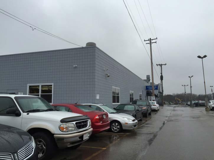
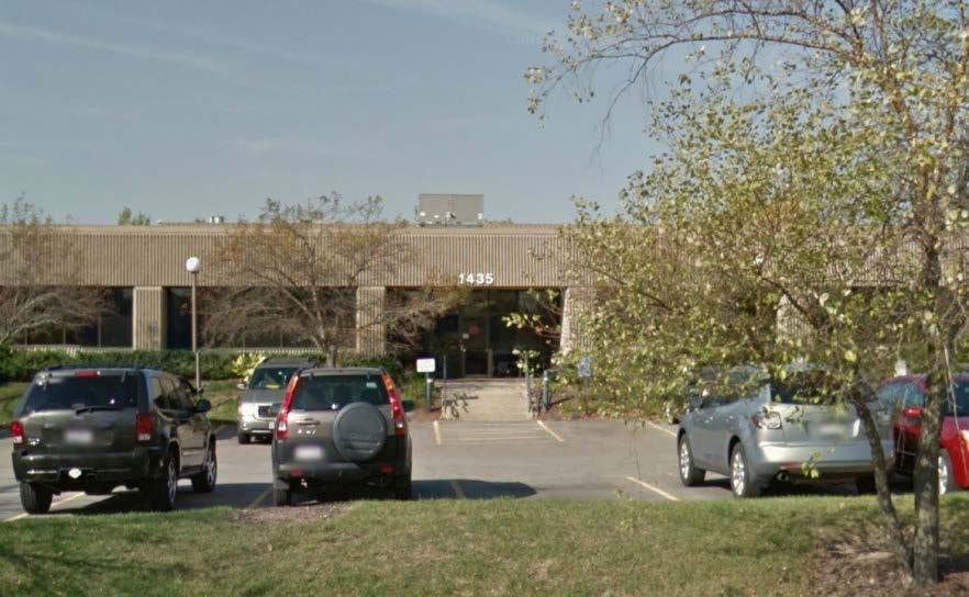
31 Parcel 17 Parcel 18 Parcel 19 (office) Parcel 19 (industrial) 27


32 Parcel 22 Parcel 23 (landfill) Parcel 20 Parcel 21 28
 Parcel 24")
33 Parcel 23 (municipal offices) Parcel 24 29
34 This page intentionally left blank 30
35 City of Wauwatosa Appendix B Redevelopment District No. 1 Resolutions 31
36 32
37 City Council Resolution 33
38 This page intentionally left blank 34
39 CDA Adoption Resolution 35
40 This page intentionally left blank 36
41 Appendix C Proof of Publication 37

42 38
RICHFIELD WAY REDEVELOPMENT PLAN
 VILLAGE OF MENOMONEE FALLS, WISCONSIN RICHFIELD WAY REDEVELOPMENT PLAN Prepared by: Village of Menomonee Falls, Wisconsin Community Development Authority Approved by the Community Development Authority
URBAN REVITALIZATION PLAN CITY OF DECORAH, IOWA 2014 DECORAH HOUSING URBAN REVITALIZATION AREA ADOPTED NOVEMBER 3, 2014
 URBAN REVITALIZATION PLAN CITY OF DECORAH, IOWA 2014 DECORAH HOUSING URBAN REVITALIZATION AREA ADOPTED NOVEMBER 3, 2014 Public Hearing held September 2, 2014 Second Public Hearing held October 6, 2014
Downtown Meridian Urban Renewal Area URBAN RENEWAL ELIGIBILITY REPORT. Prepared for The City of Meridian and The Meridian Development Corporation
 Downtown Meridian Urban Renewal Area URBAN RENEWAL ELIGIBILITY REPORT Prepared for The City of Meridian and The Meridian Development Corporation by McKibben + Cooper Architects June 19, 2002 Authorization
Village of Port Jefferson Urban Renewal Plan
 Urban Renewal Plan Village of Port Jefferson Urban Renewal Plan Port Jefferson, New York PREPARED FOR Village of Port Jefferson Village Board 121 West Broadway Port Jefferson, NY 11777 631.473.4724 PREPARED
H 7291 S T A T E O F R H O D E I S L A N D
 LC000 01 -- H 1 S T A T E O F R H O D E I S L A N D IN GENERAL ASSEMBLY JANUARY SESSION, A.D. 01 A N A C T RELATING TO TOWNS AND CITIES -- REDEVELOPMENT AGENCIES AND PROJECTS Introduced By: Representatives
INTRODUCTION INTRODUCTION REDEVELOPMENT AUTHORITIES, COMMUNITY DEVELOPMENT AUTHORITIES, AND HOUSING AUTHORITIES
 REDEVELOPMENT, COMMUNITY DEVELOPMENT, AND HOUSING Scott R. Letteney City Attorney Nicole F. Larsen Deputy City Attorney City of Racine City Attorney s Office Municipal Attorneys Institute June 15, 2017
VILLAGE OF MCFARLAND, WISCONSIN District Boundary and Project Plan
 A Planning Document For VILLAGE OF MCFARLAND, WISCONSIN District Boundary and Project Plan Redevelopment District No. 2 CDA Work Session January 6, 2010 Table of Contents Introduction... 1 Map 1: Redevelopment
City of Lawrence Neighborhood Revitalization Plan and Program: 1101/1115 Indiana Street Lawrence, KS
 City of Lawrence Neighborhood Revitalization Plan and Program: 1101/1115 Indiana Street Lawrence, KS Definition: Area - used interchangeably with Property, referring to the property located at 1101/1115
Summary. Draft Redevelopment Plan Summary Flowery Branch Tax Allocation District # 1:
 Summary Draft Redevelopment Plan Summary Flowery Branch Tax Allocation District # 1: Flowery Branch Tax Allocation District Old Town and Commercial Gateways 1 Public Hearing Presentation November 21, 2007
Delta Urban Renewal Authority Blight Study
 Delta Urban Renewal Authority Blight Study February 2017 1 Table of Contents 1. Introduction.3 1.1 Purpose..3 1.2 Colorado Urban Renewal Law..3 1.3 Study Methodology..5 2. Study Area Analysis.6 2.1 Study..6
Cent ral Neighborhoods U rban Ren ewal Plan ( )
") Central Neighborhoods Urban Renewal Plan City of Golden, Colorado Cent ral Neighborhoods U rban Ren ewal Plan (4.18.20 1 3) 010252\0001\1819714.2 Central Neighborhoods Urban Renewal Plan City of Golden,
Central Neighborhoods Urban Renewal Plan City of Golden, Colorado Cent ral Neighborhoods U rban Ren ewal Plan (4.18.20 1 3) 010252\0001\1819714.2 Central Neighborhoods Urban Renewal Plan City of Golden,
Blight and Substandard Study City of Blair, Nebraska
 Blight and Substandard Study City of Blair, Nebraska 2014 JEO Consulting Group, Inc. Project No. 131365.00 Adopted, 2014 Resolution No. Introduction Introduction Purpose of the Study This Blair Blight
CITY OF LOGAN REDEVELOPMENT AGENCY. A Resolution approving the Auto Mall Community Development Project Area Plan
 -~ LOGAN CITY UNITED IN HRVICE fstt,blished 18t6 CITY OF LOGAN REDEVELOPMENT AGENCY Resolution No. IS-03 RDA A Resolution approving the Auto Mall Community Development Project Area Plan WHEREAS, the Redevelopment
C.D. No ORDINANCENO.: 3217 INTRODUCEDBY: Vigil
 C.D. No. 2012-1 64 ORDINANCENO.: 3217 INTRODUCEDBY: Vigil AN ORDINANCE MAKING CERTAIN LEGISLATIVE FINDINGS REGARDING BLIGHT AND APPROVING THE SOUTH THORNTON URBAN RENEWAL PLAN. WHEREAS, an urban renewal
Hennepin County Department of. Housing, Community Works and Transit. Transit Oriented Development (TOD) Guidelines
 Guidelines") Hennepin County Department of Housing, Community Works and Transit 2007 Transit Oriented Development (TOD) Guidelines Hennepin County Transit Oriented Development (TOD) Bond Funds Hennepin County Housing,
Hennepin County Department of Housing, Community Works and Transit 2007 Transit Oriented Development (TOD) Guidelines Hennepin County Transit Oriented Development (TOD) Bond Funds Hennepin County Housing,
Common July 24, 2017 PROJECT
 CITY OF WAUSAU TAX INCREMENT DISTRICT ELEVEN PROJECT PLAN Economic Development Committee June 6, 2017 Finance Committee June 12, 2017 Plan Commission: June 20, 2017 Common Council: July 18, 2017 Joint
Chapter 10: Implementation
 Chapter 10: Introduction Once the Comprehensive Plan has been adopted by the City of Oakdale, the City can begin to implement the goals and strategies to make this vision a reality. This chapter will set
PREPARED BY TREASURE COAST REGIONAL PLANNING COUNCIL
 PREPARED BY TREASURE COAST REGIONAL PLANNING COUNCIL OCTOBER 12, 2017 What is a Community Redevelopment Agency? Definition of a CRA: A dependent special district in which any future increases in property
THIRD RESTATED URBAN REVITALIZATION PLAN. Citywide Urban Revitalization Area
 THIRD RESTATED URBAN REVITALIZATION PLAN for the Citywide Urban Revitalization Area City of Des Moines, Iowa As adopted and amended on October 26, 2015, by Roll Call Nos. 15-1816 and 15-1818. As further
THE REDEVELOPMENT PLAN
 PAGE 37 THE REDEVELOPMENT PLAN FUTURE LAND USE The Silver Terrace Redevelopment Area is currently designated as Redevelopment Area #4 on the City of Delray Beach Future Land Use Map (FLUM). This designation
Study Area Description Study Area Context Existing Land Use and Zoning Districts
 TABLE OF CONTENTS Table of Contents SECTION I: INTRODUCTION Definition of Blight Study Methodology Report Format SECTION II: AREA OVERVIEW AND DESCRIPTION Study Area Description Study Area Context Existing
WASHTENAW COUNTY BROWNFIELD REDEVELOPMENT AUTHORITY ACT 381 WORK PLAN TO CONDUCT ELIGIBLE DEQ RESPONSE AND/OR MSF NON-ENVIRONMENTAL ACTIVITIES
 WASHTENAW COUNTY BROWNFIELD REDEVELOPMENT AUTHORITY ACT 381 WORK PLAN TO CONDUCT ELIGIBLE DEQ RESPONSE AND/OR MSF NON-ENVIRONMENTAL ACTIVITIES 400 NORTH RIVER STREET THE HISTORIC THOMPSON BLOCK REDEVELOPMENT
74af ANTELOPE VALLEY REDEVELOPMENT PLAN
 74af T. Telegraph District Phase 2: Telegraph Flats & Telegraph Lofts East 1. Project Area Description Phase 2 will include two building subphase areas with connecting streetscape enhancements: The Telegraph
Redevelopment Project Plan and Eligibility Report for the: Cook County Project Area. Village of East Dundee, Illinois. Draft: July 18, 2012
 for the: Cook County Project Area Village of East Dundee, Illinois Draft: Created By: Vandewalle & Associates 2012 Table of Contents TABLE OF CONTENTS Table of Contents... i Executive Summary... 1 Part
DESCRIPTION OF THE DISTRICT
 DESCRIPTION OF THE DISTRICT The project plan for City of Wausau, Tax Increment District #11 has been prepared in compliance with Wisconsin Statutes Chapter 66.1105(4). The plan establishes the need for
NEIGHBORHOOD DEVELOPMENT PLAN (Urban Renewal Plan)
") NEIGHBORHOOD DEVELOPMENT PLAN (Urban Renewal Plan) March 7, 1972, As Amended Effective to December 31, 2019 CITY OF HAMILTON PLANNING DEPARTMENT February 21, 2019 2 TABLE OF CONTENTS A. Description of
NEIGHBORHOOD DEVELOPMENT PLAN (Urban Renewal Plan) March 7, 1972, As Amended Effective to December 31, 2019 CITY OF HAMILTON PLANNING DEPARTMENT February 21, 2019 2 TABLE OF CONTENTS A. Description of
WHITE PLAINS URBAN RENEWAL AGENCY
 WHITE PLAINS URBAN RENEWAL AGENCY 255 Main Street White Plains NY 10601 (914) 422-1300 December 31, 2014 NOTICE OF SPECIAL URBAN RENEWAL AGENCY MEETING AND AGENDA Date/Time: Wednesday, January 7, 2015
A PRELIMINARY FINANCIAL AND ECONOMIC REDEVELOPMENT FEASIBILITY STUDY FOR THE CITY OF FERNLEY, NEVADA
 TECHNICAL REPORT UCED 2015/16-07 A PRELIMINARY FINANCIAL AND ECONOMIC REDEVELOPMENT FEASIBILITY STUDY FOR THE CITY OF FERNLEY, NEVADA UNIVERSITY OF NEVADA, RENO A PRELIMINARY FINANCIAL AND ECONOMIC REDEVELOPMENT
DRAFT. Conservation Area Analysis. for the Southwest Corner of Shawnee Mission Parkway & Maurer Road. Shawnee, Kansas. October 2014.
 Conservation Area Analysis for the Southwest Corner of Shawnee Mission Parkway & Maurer Road Shawnee, Kansas October 2014 DRAFT Prepared by: Polsinelli PC, Development Analysis Department 99 CONSERVATION
Understanding Texas TIRZ Statute Chapter 311 Texas Tax Code
 CDFA/TEDC TIRZ SEMINAR Understanding Texas TIRZ Statute Chapter 311 Texas Tax Code Clark Stockton Lord Constitutional Authority The legislature by general law may authorize an incorporated city or town
January 1, 2010 thru March 31, 2010 Performance Report
 Grantee: Wyoming State Program Grant: B-08-DN-56-0001 January 1, 2010 thru March 31, 2010 Performance Report Grant Number: B-08-DN-56-0001 Grantee Name: Wyoming State Program Grant : $19,600,000.00 Grant
Downtown Development Focus Area: I. Existing Conditions
 Downtown Development Focus Area: I. Existing Conditions The Downtown Development Focus Area is situated along Route 1, south of the train tracks, except for the existing Unilever property. It extends west
ARTICLE 3: Zone Districts
 ARTICLE 3: Zone Districts... 3-1 17.3.1: General...3-1 17.3.1.1: Purpose and Intent... 3-1 17.3.2: Districts and Maps...3-1 17.3.2.1: Applicability... 3-1 17.3.2.2: Creation of Districts... 3-1 17.3.2.3:
Planning Justification Report
 Planning Justification Report Kellogg s Lands City of London E&E McLaughlin Ltd. June 14, 2017 Zelinka Priamo Ltd. Page i TABLE OF CONTENTS Page No. 1.0 2.0 2.1 2.2 3.0 4.0 5.0 5.1 5.2 5.3 5.4 5.5 5.6
Goals, Objectives and Policies
 Goals, Objectives and Policies 1. GOAL SUPPORT THE PROVISION OF DECENT, SAFE AND SOUND HOUSING IN A VARIETY OF TYPES, SIZES, LOCATIONS AND COSTS TO MEET THE NEEDS OF CURRENT AND FUTURE RESIDENTS OF UNINCORPORATED
G. HRA Member Area Surveys a. Area 1 Survey Sample b. Area 1-10 descriptions for surveys
 G. HRA Member Area Surveys a. Area 1 Survey Sample b. Area 1-10 descriptions for surveys CENTER CITY URBAN REVITALIZATION PLAN RANKING OF URBAN RENEWAL ACTIONS Area 1 Dwight Street Gateway This area includes
TASK 2 INITIAL REVIEW AND ANALYSIS U.S. 301/GALL BOULEVARD CORRIDOR FORM-BASED CODE
 TASK 2 INITIAL REVIEW AND ANALYSIS U.S. 301/GALL BOULEVARD CORRIDOR FORM-BASED CODE INTRODUCTION Using the framework established by the U.S. 301/Gall Boulevard Corridor Regulating Plan (Regulating Plan),
Land Use Planning Analysis. Phase 2 Drayton Valley Annexation Proposal
 Land Use Planning Analysis Phase 2 Drayton Valley Annexation Proposal Prepared for Town of Drayton Valley Prepared by Mackenzie Associates Consulting Group Limited March, 2011 TABLE OF CONTENTS 1.0 INTRODUCTION...
******************************************************************************
 AN ORDINANCE OF THE CITY COUNCIL OF THE CITY OF BAYTOWN, TEXAS, EXCLUDING LAND FROM REINVESTMENT ZONE NO. ONE, CITY OF BAYTOWN, TEXAS; INCLUDING LAND WITHIN THE ZONE; EXTENDING THE TERM OF SUCH ZONE; APPROVING
The 2004 Florida Statutes
 Page 1 of 34 The 2004 Florida Statutes CHAPTER 163 PART III COMMUNITY REDEVELOPMENT (ss. 163.330-163.463) COMMUNITY REDEVELOPMENT 163.330 Short title. 163.335 Findings and declarations of necessity. 163.336
ARTICLE B ZONING DISTRICTS
 ARTICLE B ZONING DISTRICTS Sec. 8-3021 Established. In order to protect the character of existing neighborhoods; to prevent excessive density of population in areas which are not adequately served with
CITY OF EAST PEORIA, ILLINOIS COSTCO AREA BUSINESS DISTRICT DEVELOPMENT AND REDEVELOPMENT PLAN
 CITY OF EAST PEORIA, ILLINOIS COSTCO AREA BUSINESS DISTRICT DEVELOPMENT AND REDEVELOPMENT PLAN I. INTRODUCTION The City of East Peoria (the City ) is located in Tazewell County, Illinois. In order to encourage
TAX INCREMENT FINANCING PLAN PARAGON STAR, LLC
 TAX INCREMENT FINANCING PLAN PARAGON STAR, LLC JANUARY 6, 2016 FEBRUARY 17, 2016 1 TABLE OF CONTENTS I. DEFINITIONS 4 II. TAX INCREMENT FINANCING 6 III. GENERAL DESCRIPTION OF REDEVELOPMENT PLAN AND PROJECT
4 LAND USE 4.1 OBJECTIVES
 4 LAND USE The Land Use Element of the Specific Plan establishes objectives, policies, and standards for the distribution, location and extent of land uses to be permitted in the Central Larkspur Specific
Staff Report PLANNING DIVISION COMMUNITY & ECONOMIC DEVELOPMENT. Alley Closure
 Staff Report PLANNING DIVISION COMMUNITY & ECONOMIC DEVELOPMENT To: From: Salt Lake City Planning Commission Doug Dansie, 801-535-6182, doug.dansie@slcgov.com Date: March 23, 2016 Re: PLNPCM2015-00941
HOUSING ELEMENT GOALS, OBJECTIVES, AND POLICIES
 HOUSING ELEMENT GOALS, OBJECTIVES, AND POLICIES GOAL 1: To promote the preservation and development of high-quality, balanced, and diverse housing options for persons of all income levels throughout the
Downtown & East Town CRA Expansion Plan City of Eustis
 Downtown & East Town CRA Expansion Plan City of Eustis May 2018 Contents 1 Introduction... 1 CRA Overview/History... 1 2 Existing Conditions... 2 Downtown & East Town Community Redevelopment Area Expansion...
b. providing adequate sites for new residential development
 DIVISION 2.200 SECTION 2.201 INTRODUCTION A. Purpose The purpose of the Housing Element is to establish the goal, objectives, and policies to guide housing development within Polk County over the next
Presence-Saint Joseph Medical Center Area Redevelopment Project Area
 CITY OF JOLIET, IL Presence-Saint Joseph Medical Center Area Redevelopment Project Area Tax Increment Financing Eligibility Study and Redevelopment Plan and Project November 2, 2016 CITY OF JOLIET, IL
VILLAGE OF FORRESTON
 VILLAGE OF FORRESTON Ogle County, Illinois ROUTES 26/72 & FORRESTON DOWNTOWN BUSINESS DEVELOPMENT DISTRICT Prepared by: Kathleen Field Orr & Associates 53 West Jackson Blvd., Suite 964 Chicago, Illinois
O.C.G.A. TITLE 36 Chapter 61. GEORGIA CODE Copyright 2012 by The State of Georgia All rights reserved.
 O.C.G.A. TITLE 36 Chapter 61 GEORGIA CODE Copyright 2012 by The State of Georgia All rights reserved. *** Current Through the 2011 Extraordinary Session *** TITLE 36. LOCAL GOVERNMENT PROVISIONS APPLICABLE
CENTRAL DISTRICT URBAN RENEWAL PLAN OAKLAND, CALIFORNIA. June 12, As amended up to June 20, 2006
 CENTRAL DISTRICT URBAN RENEWAL PLAN Adopted June 12, 1969 As Amended Up To June 20, 2006 CENTRAL DISTRICT URBAN RENEWAL PLAN OAKLAND, CALIFORNIA June 12, 1969 As amended up to June 20, 2006 An amended
PLANNING COMMISSION STAFF REPORT
 PLANNING COMMISSION STAFF REPORT REZONING CASE: RZ-16-001 REPORT DATE: March 8, 2016 CASE NAME: Trailbreak Partners Rezoning PLANNING COMMISSION DATE: March 16, 2016 ADDRESSES OF REZONING PROPOSAL: 5501
APPENDIX D: DEFINITIONS
 D APPENDIX D: DEFINITIONS Terms used throughout the 2040 Comprehensive Plan should be interpreted using the definitions provided in this appendix. For interpretation of any term not defined, defer to the
July 1, 2018 thru September 30, 2018 Performance Report
 Grantee: Grant: Milwaukee, WI B-08-MN-55-0006 July 1, 2018 thru September 30, 2018 Performance Report 1 Grant Number: B-08-MN-55-0006 Grantee Name: Milwaukee, WI Grant Award Amount: $9,197,465.00 LOCCS
Glendale Housing Development Project Plan
 Glendale Housing Development Project Plan Draft for Public Review May 29, 2015 Table of Contents I. Introduction... 1 II. Description of Project... 1 A. Boundary of Housing Development Project... 1 B.
M E M O R A N D U M. MEETING DATE: July 10, 2018 CASE NUMBER: PC
 M E M O R A N D U M TO: FROM: PREPARED BY: Plan Commission Technical Review Committee Tim Semmann, AICP Principal Planner DATE DISTRIBUTED: July 3, 2018 MEETING DATE: July 10, 2018 CASE NUMBER: PC18-2603
Staff Report PLANNED DEVELOPMENT. Salt Lake City Planning Commission. From: Lauren Parisi, Associate Planner; Date: December 14, 2016
 Staff Report PLANNING DIVISION COMMUNITY & NEIGHBORHOODS To: Salt Lake City Planning Commission From: Lauren Parisi, Associate Planner; 801-535-7932 Date: December 14, 2016 Re: 1611 South 1600 East PLANNED
January 1, 2018 thru March 31, 2018 Performance Report
 Grantee: Grant: Milwaukee, WI B-11-MN-55-0006 January 1, 2018 thru March 31, 2018 Performance Report 1 Grant Number: B-11-MN-55-0006 Grantee Name: Milwaukee, WI Grant Award Amount: $2,687,949.00 LOCCS
City of Rochester. Planned Development District No. 12 [Adopted by Ord. No ]
![City of Rochester. Planned Development District No. 12 [Adopted by Ord. No ]](/thumbs/83/87498370.jpg "City of Rochester. Planned Development District No. 12 [Adopted by Ord. No ]") City of Rochester Planned Development District No. 12 [Adopted 5-11-2010 by Ord. No. 2010-153] A. Purpose. (1) The Eastman Business Park Planned Development District (PD #12) encompasses over 160 acres
City of Rochester Planned Development District No. 12 [Adopted 5-11-2010 by Ord. No. 2010-153] A. Purpose. (1) The Eastman Business Park Planned Development District (PD #12) encompasses over 160 acres
CITY OF ANDOVER NEIGHBORHOOD REVITALIZATION PLAN
 CITY OF ANDOVER NEIGHBORHOOD REVITALIZATION PLAN Adopted August 25, 2015 Expires December 31, 2018 Attorney General Office: Adopted CITY OF ANDOVER, KANSAS NEIGHBORHOOD REVITALIZATION PLAN PURPOSE This
Westerly Creek Village Conditions Inventory and Environmental Assessment A U R O R A
 Westerly Creek Village Conditions Inventory and Environmental Assessment A U R O R A Table of Contents Section 1: Study Overview... 1 Section 2: Colorado Urban Renewal Statutes and Blighted Areas... 3
Downtown North CRA Expansion Area. Findings of Necessity Study
 Downtown North CRA Expansion Area Panama City, Florida Project # 527118097 September 2018 Prepared for: City of Panama City Page ii PANAMA CITY DOWNTOWN NORTH CRA EXPANSION AREA FINDINGS OF NECESSITY STUDY
HOUSING ELEMENT GOALS, OBJECTIVES, & POLICIES
 HOUSING ELEMENT GOALS, OBJECTIVES, & POLICIES GOAL H-1: ENSURE THE PROVISION OF SAFE, AFFORDABLE, AND ADEQUATE HOUSING FOR ALL CURRENT AND FUTURE RESIDENTS OF WALTON COUNTY. Objective H-1.1: Develop a
CITY COUNCIL AND BURA AGENDA MEMORANDUM
 City and County of Broomfield, Colorado CITY COUNCIL AND BURA AGENDA MEMORANDUM To: From: By: Agenda Title Mayor, City Council, and Broomfield Urban Renewal Authority Charles Ozaki, City and County Manager
Appendix A. A.1 Finding of Necessity Resolution. A.2 Urban Redevelopment Plan Adoption Resolution. A.3 Urban Redevelopment Agency Resolution
 Appendix A A.1 Finding of Necessity Resolution A.2 Adoption Resolution A.3 Urban Redevelopment Agency Resolution Appendix A 1 Appendix A 2 Appendix A 3 Appendix A 4 Appendix A 5 Appendix A 6 RESOLUTION
HOUSING ELEMENT. 3. group and foster home construction. 1. increase the supply of new affordable housing with: a regional housing trust fund;
 Goal 8.0. Facilitate an adequate supply of decent, safe, and sanitary housing in suitable neighborhoods, including housing for special needs populations; available in a range of housing types, architectural
COMMUNICATION URBAN DESIGN REVIEW BOARD CITY OF DES MOINES, IOWA NOVEMBER 1, 2016, 2016 MEETING
 COMMUNICATION URBAN DESIGN REVIEW BOARD CITY OF DES MOINES, IOWA NOVEMBER 1, 2016, 2016 MEETING Subject: Recommendation Prepared by: PRELIMINARY DESIGN AND FINANCIAL REVIEW 401 SE 6 TH STREET- CONNOLLY
HOUSING ELEMENT OF THE CITY OF PEMBROKE PINES COMPREHENSIVE PLAN ADOPTION DOCUMENT
 HOUSING ELEMENT OF THE CITY OF PEMBROKE PINES COMPREHENSIVE PLAN RULES 9J-5.010, FAC City of Pembroke Pines, Florida ADOPTION DOCUMENT HOUSING ELEMENT HOUSING ELEMENT ADOPTION DOCUMENT VI. GOALS, OBJECTIVES
CITY OF NAPLES STAFF REPORT
 Meeting of 05/13/15 Conditional Use Petition 15-CU3 CITY OF NAPLES STAFF REPORT To: Planning Advisory Board From: Planning Department Subject: Conditional Use Petition 15-CU3 Petitioner: Hazelden Betty
TABLE OF CONTENTS. I. Introduction II. Statutory Basis for Business District III. Blight Analysis... 7
 AI RPORT BUSI NESSDI STRI CT REDEVELOPMENT PLAN&PROJECT Febr uar y12,2018 TheVi l l ageof BETHALTO,I L TABLE OF CONTENTS SECTION PAGE I. Introduction... 2 II. Statutory Basis for Business District... 3
FUTURE LAND USE. City of St. Augustine Comprehensive Plan EAR-Based Amendments
 FUTURE LAND USE City of St. Augustine Comprehensive Plan EAR-Based Amendments Future Land Use Element FLU Goal To create an environment within the City and adjacent areas in which its residents have the
PC Staff Report 11/18/2013 Z Item No. 1-1
 Z-13-00401 Item No. 1-1 PLANNING COMMISSION REPORT Regular Agenda - Public Hearing Item PC Staff Report 11/18/2013 ITEM NO. 1: Z-13-00401 IG (General Industrial) District TO CS (Strip Commercial) District;
DIVISION 1 PURPOSE OF DISTRICTS
 ARTICLE 2 ZONING DISTRICTS AND MAP DIVISION 1 PURPOSE OF DISTRICTS Section 2.101 Zoning Districts. For the purpose of this Ordinance, the City of Richmond is hereby divided into districts as follows: DISTRICT
GUIDELINES AND CRITERIA. For Granting Tax Abatement in the North Killeen Revitalization Area. Designated by the City of Killeen, Texas
 GUIDELINES AND CRITERIA For Granting Tax Abatement in the North Killeen Revitalization Area Designated by the City of Killeen, Texas Under Tax Code, Chapter 312 I. PURPOSE The designation of a Tax Abatement
Project Plan. Amendment #1 of Tax Incremental Finance District No. 8. City of Tomah, WI Project No
 Project Plan Amendment #1 of Tax Incremental Finance District No. 8 City of Tomah, WI Project No. 67007 Draft: October 3, 2016 Date of City Council Approval: 09-13-2016 Note, this is the first Project
CITY OF HIAWATHA, IOWA TOWN VILLAGE CENTER URBAN REVITALIZATION PLAN. for the TOWN VILLAGE CENTER URBAN REVITALIZATION AREA
 CITY OF HIAWATHA, IOWA TOWN VILLAGE CENTER URBAN REVITALIZATION PLAN for the TOWN VILLAGE CENTER URBAN REVITALIZATION AREA 2018 1 INTRODUCTION The Urban Revitalization Act, Chapter 404 of the Code of Iowa,
OPPORTUNITY TO ACQUIRE AN INDUSTRIAL BUILDING PART OF THE SOUTH HILL SAP
 8825 SHEPARD ROAD SE CALGARY, ALBERTA OPPORTUNITY TO ACQUIRE AN INDUSTRIAL BUILDING PART OF THE SOUTH HILL SAP Mike Warner, + 1 403 261 1127 marc.rosso@cushwake.com + 1 403 261 1165 mike.warner@cushwake.com
2015 Downtown Parking Study
 2015 Downtown Parking Study City of Linden Genesee County, Michigan November 2015 Prepared by: City of Linden Downtown Development Authority 132 E. Broad Street Linden, MI 48451 www.lindenmi.us Table of
This page intentionally left blank.
 This page intentionally left blank. Page 2 of 39 Table of Contents I. Introduction...4 II. III. Community Redevelopment Act Overview...4 Study Area...7 A. General Description of Area...7 B. Zoning...8
City of. Moultrie. Urban Redevelopment Plan
 City of Moultrie Urban Redevelopment Plan Table of Contents Introduction... 3 Redevelopment Goals and Objectives... 4 Consistency with the Comprehensive Plan... 5 Community s Land use Objectives... 6 Boundaries
Section: FS Financial Services. Department: Finance. FS-03 Tangible Capital Asset Policy. Policy Statement LEDUC COUNTY MUNICIPAL POLICY
 FS-03 Tangible Capital Asset Policy Policy Statement Any object purchased for use by the County whose individual cost is less than the threshold and with a life span of less than one year shall not be
Hamilton County Regional Planning Commission
 Hamilton County Regional Planning Commission March 1, 2012 Colerain Township Staff Report Zone Map Amendment: Case No.: ZA2012-01 Joseph Toyota Prepared By: Amy Bancroft, Land Use Planner ACTION REQUESTED:
Proposed Development at Ajax Plaza Windcorp Grand Harwood Place Ltd.
 Proposed Development at Ajax Plaza Windcorp Grand Harwood Place Ltd. Presentation to Ajax Council July 4, 2013 Introduction 1. Background 2. Planning Policies and Regulations 3. Downtown Community Improvement
Planning Justification Report
 Planning Justification Report 101 Kozlov Street, Barrie, Ont. Destaron Property Management Ltd. November 2015 Revised February 2017 TABLE OF CONTENTS Page 1.0 INTRODUCTION... 1 2.0 DESCRIPTION OF SUBJECT
City of Brandon Brownfield Strategy
 City of Brandon Brownfield Strategy 2017 Executive Summary A brownfield is a property, the expansion, redevelopment, or reuse of which may be complicated by the presence or potential presence of a hazardous
RD:SSL:JMD 11/23/2015 RESOLUTION NO.
 RD:SSL:JMD 11/23/2015 RESOLUTION NO. A RESOLUTION OF THE COUNCIL OF THE CITY OF SAN JOSE AMENDING THE NORTH SAN JOSE AREA DEVELOPMENT POLICY RELATED TO REDUCED TRAFFIC IMPACT FEES TO (1) EXTEND THE DEADLINE
KNOXVILLE CITY GOVERNMENT. Mayor - Honorable Bill Haslam. Vice-Mayor Mark A. Brown Councilman Joe Hultquist
 KNOXVILLE CITY GOVERNMENT Mayor - Honorable Bill Haslam Vice-Mayor Mark A. Brown Councilman Joe Hultquist Councilman Steve Hall Councilwoman Marilyn Roddy Councilman Rob Frost Councilman Bob Becker Councilwoman
South Sprecher Road, Madison, WI
 August 14, 2018 Letter of Intent Land Use Application Development Name: Former Rodefeld Farm South Sprecher Road, Madison, WI Project Summary The proposed project consists of two separate elements at this
AN ORDINANCE REGULATING AND CONTROLLING SHARED PARKING IN THE CITY OF MADISON, MISSISSIPPI March 22, 2006
 AN ORDINANCE REGULATING AND CONTROLLING SHARED PARKING IN THE CITY OF MADISON, MISSISSIPPI March 22, 2006 Introduction Cumulative parking requirements for mixed-use occupancies or shared facilities may
Uptown Business Improvement District. Operating Plan. Approved by the City of Racine Common Council:
 Uptown Business Improvement District Operating Plan 2010 Approved by the City of Racine Common Council: Uptown Business Improvement District Operating Plan - 2010 Table of Contents I. Preface Page 3 II.
REPORT TO PLANNING & ZONING COMMISSION - CITY OF MARYLAND HEIGHTS
 APPLICATION NUMBER APPLICATION (PROJECT) NAME APPLICANT NAME PROPERTY OWNER NAME CUP16-0013 POHLMAN, LLC Pohlman, LLC 140 Long Road, Chesterfield, Missouri 63005 JDDC, Ltd. 8677 Tyler Boulevard, Mentor,
Maryland Park Lake District
 Maryland Park Lake District A REGIONAL DEVELOPMENT OPPORTUNITY City of Maryland Heights Area Context 2,535 Acres northwest of MO RT 364 (Page Ave Extension) Protected by a 500-Year COE/FEMA-certified levee
True North Commons Conditions Survey
 True North Commons Conditions Survey Colorado Springs, Colorado December 2018 Prepared for: Colorado Springs Urban Renewal Authority (CSURA) and City of Colorado Springs City Council Prepared by: RickerΙCunningham
South Hadley Electrical Light Department. Site Feasibility Study
 South Hadley Electrical Light Department Site Feasibility Study 430 Main Street Agawam, MA 01001-1827 Tel. (413) 786-9600 www.reinhardtassoc.com Introduction 1 Existing SHELD Main Street Facility This
The Maryland-National Capital Park and Planning Commission Prince George's County Planning Department Development Review Division
 The Maryland-National Capital Park and Planning Commission Prince George's County Planning Department Development Review Division 301-952-3530 Note: Staff reports can be accessed at www.mncppc.org/pgco/planning/plan.htm.
VILLAGE OF MT. HOREB, WISCONSIN TAX INCREMENTAL FINANCE DISTRICT #5 PROJECT PLAN. April 8, Prepared By: MSA Professional Services, Inc.
 VILLAGE OF MT. HOREB, WISCONSIN TAX INCREMENTAL FINANCE DISTRICT #5 PROJECT PLAN April 8, 2009 Prepared By: MSA Professional Services, Inc. TABLE OF CONTENTS Page I. INTRODUCTION AND PURPOSE 3 II. STATEMENT
EVALUATION AND APPRAISAL REPORT OF THE CITY OF FELLSMERE COMPREHENSIVE PLAN APPENDIX D HOUSING ELEMENT
 OBJECTIVE H-A-1: ALLOW AFFORDABLE HOUSING AND ADEQUATE SITES FOR VERY LOW, LOW, AND MODERATE INCOME HOUSING. The City projects the total need for very low, low, and moderate income-housing units for the
Section 4 Master Plan Framework
 Section 4 Master Plan Framework 4.1 PURPOSE The Master Plan, as an implementation tool of the SPC District, establishes the primary framework for the overall development of the Property. Detailed site
KEARNY COUNTY, KANSAS NEIGHBORHOOD REVITALIZATION PLAN
 KEARNY COUNTY, KANSAS NEIGHBORHOOD REVITALIZATION PLAN Effective Date October 31, 2011 Reviewed & Revised July 9, 2013 February 13, 2015 1 KANSAS NEIGHBORHOOD REVITALIZATION ACT K.S.A. 1996 Supp. 12-17,