Common July 24, 2017 PROJECT
|
|
|
- Marian Bradley
- 5 years ago
- Views:
Transcription
1 CITY OF WAUSAU TAX INCREMENT DISTRICT ELEVEN PROJECT PLAN Economic Development Committee June 6, 2017 Finance Committee June 12, 2017 Plan Commission: June 20, 2017 Common Council: July 18, 2017 Joint Review Board: July 24, 2017 PROJECT PLAN DATED: July 24, 2017
2 Tale of Contents DESCRIPTION OF THE DISTRICT... 2 PROJECT PLAN OBJECTIVES... 2 STATEMENT OF KIND, NUMBER AND LOCATION OF THE PROPOSED PUBLIC WORKS, PROJECT COSTS AND IMPROVEMENTS WITHIN THE DISTRICT OR THE ½ MILE BUFFER ZONE... 3 PROJECT COSTS LOCATED WITHIN 1/2MILE OUTSIDE OF THE DISTRICT BOUNDARIES... 4 LIST OF ESTIMATED NON-PROJECT COSTS... 4 ANNEXED PROPERTY... 5 CHANGES IN ZONING ORDINANCES, MASTER PLAN, MAP, BUILDING CODE AND CITY ORDINANCES... 5 RELOCATION... 5 ORDERLY DEVELOPMENT OF THE CITY OF WAUSAU... 5 EXISTING USES AND CONDITIONS OF REAL ESTATE... 5 EQUALIZED VALUE TEST... 5 ECONOMIC FEASIBILITY STUDY... 6 METHODS OF FINANCING AND THE TIME WHEN SUCH COSTS OR MONETARY OBLIGATIONS RELATED THERETO ARE TO BE INCURRED... 6 SUMMARY OF FINDINGS... 6 PROJECT COSTS... 8 WAUSAU CHEMICAL TAX INCREMENT WORKSHEET... 9 GREAT LAKES CHEESE TAX INCREMENT WORKSHEET... 9 FUTURE DEVELOPMENT INCREMENT WORKSHEET USES OF FUNDS CASH FLOW DEBT SCHEDULE BAN REFINANCING DEBT SCHEDULE PHASE DEBT SCHEDULES PHASE DEBT SCHEDULES OTHER IMPROVEMENTS PHASED STREET AND UTILITY WORK AND LOT PLAN CONSTRUCTION COST ESTIMATE MAP OF TAX INCREMENT DISTRICT NUMBER ELEVEN MAP OF ½ MILE AREA SURROUNDING TAX INCREMENT DISTRICT NUMBER ELEVEN MAP - LAND USES WITHIN TAX INCREMENT DISTRICT NUMBER ELEVEN LIST OF PROPERTIES WITHIN TAX INCREMENT DISTRICT ELEVEN LEGAL DESCRIPTION OF THE DISTRICT OPINION OF THE CITY ATTORNEY RESOLUTION OF THE COMMON COUNCIL RESOLUTION OF THE JOINT REVIEW BOARD
3 DESCRIPTION OF THE DISTRICT The project plan for City of Wausau, Tax Increment District #11 has been prepared in compliance with Wisconsin Statutes Chapter (4). The plan establishes the need for the district, details the improvements and project costs, and provides a map of the district and 1/2 mile buffer zone. The District proposed is an industrial district of approximately 498 acres. The City has successfully secured approximately 205 acres of land adjacent to our existing Business Campus for development. The district boundaries include this newly acquired property along with other vacant Business Campus parcels. The boundaries established will position the city to respond quickly to industrial development opportunities. RA Smith National and Becher Hoppe developed a master plan for the newly acquired parcel. The plan identified roadways, utilities, access, development sites and infrastructure. In addition, the consultants conducted a wetland delineation study and examined the subsurface with twenty test pits. This masterplan provided a recommended infrastructure implementation plan and cost estimates. 2 The City has successfully negotiated the relocation of two industrial companies to the newly acquired property. Both Wausau Chemical and Great Lakes Cheese are currently located on the east side of the Wisconsin River immediately north of the downtown. Both of these companies will transfer their existing properties to the city for redevelopment. Statistics on these new developments is as follows: Great Lakes Cheese: Facility and site investment of approximately $50million Equipment investment of approximately $28million Retain an employment base of 200 Increase employment base of 100 Construction to be completed in 2018 City to contribute 50% of the increment generated over a period of 10 years not to exceed $5,900,000 City to provide an additional $500,000 contingency for poor soils. City to convey their new project site for $1 Wausau Chemical Facility and site investment of approximately $10 million Construction to be completed by June 1, 2019 City to convey project site of 15 acres for $1 City to contribute $7,950,000 to defray construction and relocation $4,000,000 will be allocated to TID #11. The development agreements for both projects are being drafted. PROJECT PLAN OBJECTIVES Tax Increment District Number Eleven objectives include: a. Enhance the development and foster renewal of industrial sites within and adjacent to the District. b. Accommodate new industries and the expansion of existing industries in the business park.
4 c. Increase the employment opportunities available in the community. d. Increase per capita income in the community. e. Strengthen the economic well-being and economic diversity of the City. f. Provide appropriate financial incentives to encourage business expansion and attraction, thereby facilitating the creation of new jobs and increased tax base. g. Improve infrastructure, attractiveness and amenities of the business park to remain competitive within the market. h. Reduce the financial risk to the taxpayer by timing the implementation of the Project Plan with the creation of additional property value through business expansions and redevelopment. STATEMENT OF KIND, NUMBER AND LOCATION OF THE PROPOSED PUBLIC WORKS, PROJECT COSTS AND IMPROVEMENTS WITHIN THE DISTRICT OR THE ½ MILE BUFFER ZONE The proposed public works and improvements are outlined below. The specific kind, number, location and estimated costs are based upon preliminary plans and concepts. These may be modified as to kind, number, location and costs allocated to the district at any time during project execution based on more definitive construction plans, studies, engineering work, developer needs, feasibility studies and construction plans without amendment of this plan. Any expenditure directly or indirectly related to the costs outlined below is considered project costs and eligible to be paid with tax increment revenues. Project costs will be diminished by any investment income, land sale proceeds, special assessments or other income generated. 1. PROPERTY ACQUISITION FOR DEVELOPMENT AND/OR REDEVELOPMENT. The cost of property acquired, transaction costs associated with the purchase such as fee title, easements, appraisals, consultant and broker fees, closing costs, surveying and mapping and site improvement necessary to make the project suitable for development/redevelopment will be compared to property sales. If total project costs incurred by the City to acquire and prepare the site for development/redevelopment exceed the revenues or other consideration received from the sale or lease of the property, the deficit amount shall be considered real property assembly costs as defined in State Statutes Section (2)(f)1.c., and subject to recovery as an eligible project cost. 2. ENVIRONMENTAL AUDITS AND REMEDIATION. Any cost incurred by the City related to environmental audits, testing, and remediation is eligible project costs. 3. DEMOLITION AND SITE WORK. Development and redevelopment of the area may require site preparation such as demolition, grading, fill, construction of retaining walls and other activities related to modifying property to make it suitable for private sector development or redevelopment. 4. STREETS. The City will construct, reconstruct or make pavement improvements to streets, access drives and parking areas. Eligible costs include but are not limited to, excavation; removal or placement of fill; construction of road base; asphalt or concrete paving or repaving; installation or replacement of medians, shoulders, culverts, drainage ditches and catch basins; bicycle accommodations, retaining walls, street lighting; installation or replacement traffic signals, traffic signs and pavement markings. 5. WATER, SEWER AND STORMWATER IMPROVEMENTS - to allow for development and/or redevelopment the City may need to construct, alter, rebuild, or expand utility infrastructure within the district. Eligible project costs would include, but are not limited to the following: distribution and collection mains; manholes, and supporting structures; hydrants; service laterals; interceptor sewers; booster station; lift station; stormwater infiltration, filtration and detention; and all related appurtenances. 3
5 6. OTHER UTILITIES to allow for development the City will seek the extension of electric, gas, telephone and cable to the sites. 7. STREETSCAPING/LANDSCAPING AND WAYFINDING SYSTEM. The City may incur costs associated with streetscape, landscape and wayfinding system to improve the aesthetics; attract quality development and market the business park and its tenants. 8. PEDESTRIAN TRAIL. To encourage private development and enhance the work environment for employees and recreation opportunities for the community the city seeks to add walking trails within the district and the 1/2mile boundaries. 9. INTERCHANGE IMPROVEMENTS. The City will make improvements to the underpass at the 72 nd Avenue Interchange. Improvements will include pavement and pedestrian improvements and landscaping and signage. 10. DEVELOPMENT INCENTIVES. These costs include but are not limited to, cash grants, loans, incentives and any expenditures of this type to induce development and ensure project feasibility. All development projects that receive some form of direct or indirect development assistance will first enter into a development agreement that outlines the terms of the TID contributions and the developer obligations. Developer incentives may be in the form of direct cash grants or in pay as you go payments over time. 11. FINANCE COSTS Interest, financing and debt issuance costs, financial advisor fees are included as project costs. 12. ADMINISTRATIVE COSTS. These include but are not limited to a portion of the staff salaries associated with managing the project plan through implementation and termination. Accounting and legal fees associated with the management of the plan. Engineering, surveying, inspection, planning, community development, financial and legal are a sample of staff activities involved in managing these plans. The plan is neither meant to be a budget nor an appropriation or commitment of funds for specific projects within the TID district. The plan does provide a framework for managing project expenditures and generating the revenue needed to balance those expenditures. All costs included in the plan are estimates based upon the best information currently available. The plan must remain flexible to accommodate alternative proposals related to the size, design and location of public and private improvements within the district boundaries. Flexibility in the means of financing the project costs and the timing for implementing project plan elements is incorporated into the plan by reference to allow the City to adapt to or capitalize upon changing conditions. This flexibility will help ensure that improvements and project expenditures are programmed in the most cost effective manner. Similarly, various financing means which are not feasible today may be appropriate in the future as implementation proceeds. PROJECT COSTS LOCATED WITHIN 1/2MILE OUTSIDE OF THE DISTRICT BOUNDARIES Project costs located within the ½ mile zone include: Wayfinding signage Pedestrian Trail Street Improvements 72 nd Avenue Interchange Improvements Development Incentives LIST OF ESTIMATED NON-PROJECT COSTS There are no anticipated non-project costs associated with this Plan. 4
6 ANNEXED PROPERTY The 205 acres was recently annexed into the City. Pursuant to Wisconsin Statutes Chapter (4)(gm)1, the City will pay to the town an amount equal to the property taxes levied on the territory by the town at the time of the annexation for each of the next five years. CHANGES IN ZONING ORDINANCES, MASTER PLAN, MAP, BUILDING CODE AND CITY ORDINANCES No specific zoning, building code or city ordinance changes are proposed which are directly related to the adoption of this project plan. Any changes which may later be proposed for land within the district will be considered in accordance with existing State laws, local ordinances and established procedures. The city confirms that any real property within the district that is found suitable for industrial sites and is zoned for industrial uses will remain zoned for industrial use for the life of the tax incremental district. 5 RELOCATION Chapter 32 of the Wisconsin Statutes will be followed relative to displacement of residents and businesses from the property acquired as part of this project plan. A separate relocation plan for any public acquisitions that involve displacement of persons will be prepared and approved by the Wisconsin Department of Industry, Labor and Human Relations prior to initiation of negotiations to acquire the property occupied by potential displacees. ORDERLY DEVELOPMENT OF THE CITY OF WAUSAU The creation of TID #11 and implementation of the projects in this project plan are consistent with the economic development goals identified in the City of Wausau Comprehensive Plan and also with several of the objectives, policies, and economic development strategies established in that report. The planned projects will promote the orderly development of the City of Wausau along with fostering renewal and reuse of property within the business park. By utilizing the provisions of the Tax Increment Law, the City can increase property values through development projects that result in increased tax base. The creation of TID #11 will add to the tax and employment base of the community, will generate positive secondary impacts in the community through increased local disposable incomes, and improve public facilities in the community. EXISTING USES AND CONDITIONS OF REAL ESTATE The map on Page 21 shows the existing generalized uses in the district, all parcels in the district but for one are vacant and owned by the City. The table on page 22 presents the list of individual parcels and the current equalized value. EQUALIZED VALUE TEST Wisconsin s Tax Increment Law (4)(gm)4.c. requires that the equalized value of the taxable property in the proposed district, plus the value of increment of all existing Tax Incremental Districts, does not exceed 12 EQUALIZED VALUE TEST TID DISTRICT BASE YEAR 2016 DISTRICT EQUALIZED VALUE 2016 DISTRICT INCREMENT VALUE ,438,200 80,619, ,242,300 52,868, ,440,700 58,731, ,662,900 19,137, ,478,200 4,069, ,067, , ,938,800 4,225,800 $ 455,268,900 $ 220,486,400 VALUE OF TAX INCREMENT DISTRICT ELEVEN 71,200 TOTAL VALUE WITH NEW DISTRICT $ 220,557,600 TOTAL CITY EQUALIZED VALUE $ 2,608,454,600 12% TEST 8.46%
7 percent of the total equalized value of taxable property within the City. The table to the right provides the necessary calculation showing the City maintains sufficient capacity to create the district. ECONOMIC FEASIBILITY STUDY The project costs, increment worksheets, and sources and uses of funds presented on Pages 8 through 13, presents the projected sources and uses of funds including detailed project costs and the related borrowing plans. The timing of development is based upon developer discussions along with assumptions based upon development in the existing business campus. The cash flow indicates that project costs will be paid in full in Annual and accumulated deficits disclosed within the plan are managed by the City during annual debt planning and budget preparation to prevent over investment. Flexibility within the project plan will allow the City to time projects to coincide with development to ensure that the plan remains affordable. The plan assumes growth in value of $58,800,000 during the life of the district. The majority of the growth is attributed to Great Lakes Cheese and Wausau Chemical. TAX INCREMENT. Based upon the existing allocation of tax increment, the impact to the overlying jurisdictions over the maximum life of the district is: City 36.41% $11,172,188 County 18.42% $5,653,081 School District 40.56% $12,447,676 Technical College 4.61% $1,413,792 METHODS OF FINANCING AND THE TIME WHEN SUCH COSTS OR MONETARY OBLIGATIONS RELATED THERETO ARE TO BE INCURRED The City strives to complete projects in an efficient and effective manner while limiting interest expense. The land acquisition, infrastructure and development commitments of this project are significant. The City worked with our financial advisors to develop a plan that will minimize deficits in the early years of the project. The City s developer obligation to Wausau Chemical, the phase one infrastructure and a portion of the land acquisition will be financed with Interest only - Taxable Bond Anticipation Notes for a period of five years. This will allow the private development construction period to conclude and increment stabilization. The City will then refinance the debt using the appropriate financing method allowed by state law including general obligation notes or bonds or CDA revenue bonds. Sample amortization schedules have been incorporated into the project plan. SUMMARY OF FINDINGS As required by s Wisconsin Stats., and as documented in this Project Plan and the related attachments contained and referenced herein, the following findings are made: % $30,686,737 That but for the creation of this District, the development projected to occur as detailed in this Project Plan: 1) would not occur; or 2) would not occur in the manner, at the values, or within the timeframe desired. o The sites that are candidates for development and redevelopment have not and are not expected to develop without public investment due to the inherent challenges of these industrial sites due to environmental problems on the site, blight due to aged improvements and design issues with industrial facilities. 6
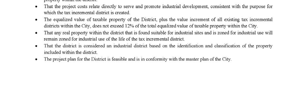
8 The economic benefits of the District, as measured by increased employment, business & personal income, and property value, are sufficient to compensate for the costs of the improvements. o Reinvestment in existing businesses and redevelopment of blighted and vacant sites will increase property values and provide expanded employment opportunities within the community. While these benefits support the missions of each of the taxing jurisdictions, they do not provide direct dollars to pay for the project costs. As presented in the cash flow projections the creation of the district provides a sound financing mechanism to accomplish the project costs outlined. The benefits for the proposal outweigh the anticipated tax increments to be paid by the owners of property in the overlying taxing jurisdictions. o If approved, the district creation will become effective for property valuation purposes as of January 1, Thus, the values of existing development will be frozen and the property taxes collected on this base value will continue to be distributed to the taxing entities. Taxes on future improvements and development will be used to offset development costs incurred by the City as listed in the plan. Since development is not considered likely to occur without the use of Tax Increment Financing, and that economic benefits related to this development such as job growth, per capita income growth, improved diversity and economic vitality of the city benefit all taxing entities, the City reasonably concludes that the overall benefits of the District outweigh the anticipated tax increments to be paid by the owners of property to the overlying taxing jurisdictions. Not less than 50%, by area of the real property within the district is suitable for industrial sites within the meaning of s and has been zoned for industrial use. o Compliance is demonstrated on the zoning map. That the improvement of the area is likely to enhance significantly the value of substantially all of the other real property within the district. o Industrial property owners today expect amenities proposed in the project plan including wayfinding, streetscape and walkways. These improvements along with the redevelopment of blighted properties will have a positive impact on property values. In addition, it will improve the desirability and marketability of the individual properties located within the district. That the project costs relate directly to serve and promote industrial development, consistent with the purpose for which the tax incremental district is created. o The projects outlined in the plan will improve existing infrastructure, provide additional amenities and redevelop specific parcels. The projects are consistent with the promotion of industrial development. The equalized value of taxable property of the District, plus the value increment of all existing tax incremental districts within the City, does not exceed 12% of the total equalized value of taxable property within the City. o Compliance is demonstrated within the project plan. That any real property within the district that is found suitable for industrial sites and is zoned for industrial use will remain zoned for industrial use of the life of the tax incremental district. o The City s comprehensive plan supports clustering of industrial properties which is in compliance with this requirement. That the district is considered an industrial district based on the identification and classification of the property included within the district. The project plan for the District is feasible and is in conformity with the master plan of the City. The City determines that less then 35% of the territory within the District will be devoted to retail business at the end of the District s maximum expenditure period. 7
9 PROJECT COSTS Business Campus ExpansionInfrastructure Construction Costs: Phase 1 $ 4,465,750 Phase 2 1,655,700 Phase 3 2,670,550 8,792,000 Land Assembly Deficits: 1,575,000 Wayfinding: 100,000 Development Incentives: Wausau Chemical 4,000,000 Great Lakes Cheese 5,900,000 Great Lakes Cheese - site contingency 500,000 72nd Avenue Underpass Improvements: 600,000 Street Improvements: 700,000 Pedestrian Trails: 1,500,000 Interest and Financing Charges 4,399,000 Administrative Costs 137,000 $ 28,203,000 8
10 WAUSAU CHEMICAL TAX INCREMENT WORKSHEET Construction Year Value Added City of Wausau Tax Increment District Eleven Tax Increment Projection Worksheet Total Valuation Added Wausau Chemical January 1, Budget Valuation Year/Revenue Year Year Tax Rate Tax Increment $27.47 $ $7,000,000 $7,000, $27.47 $192, $7,000, $27.47 $192, $7,000, $27.47 $192, $7,000, $27.47 $192, $7,000, $27.47 $192, $7,000, $27.47 $192, $7,000, $27.47 $192, $7,000, $27.47 $192, $7,000, $27.47 $192, $7,000, $27.47 $192, $7,000, $27.47 $192, $7,000, $27.47 $192, $7,000, $27.47 $192, $7,000, $27.47 $192, $7,000, $27.47 $192, $7,000, $27.47 $192, $7,000, $27.47 $192, $7,000, $27.47 $192, $7,000, $27.47 $192, $7,000, $27.47 $192,290 $3,845,800 9
11 GREAT LAKES CHEESE TAX INCREMENT WORKSHEET Construction Year Value Added Total Valuation Added City of Wausau Tax Increment District Eleven Tax Increment Projection Worksheet Great Lakes Cheese Co, Inc. January 1, Valuation Year Budget Year/Revenue Year Tax Rate Tax Increment $27.47 $ $43,000,000 $43,000, $27.47 $1,181, $43,000, $27.47 $1,181, $43,000, $27.47 $1,181, $43,000, $27.47 $1,181, $43,000, $27.47 $1,181, $43,000, $27.47 $1,181, $43,000, $27.47 $1,181, $43,000, $27.47 $1,181, $43,000, $27.47 $1,181, $43,000, $27.47 $1,181, $43,000, $27.47 $1,181, $43,000, $27.47 $1,181, $43,000, $27.47 $1,181, $43,000, $27.47 $1,181, $43,000, $27.47 $1,181, $43,000, $27.47 $1,181, $43,000, $27.47 $1,181, $43,000, $27.47 $1,181, $43,000, $27.47 $1,181, $43,000, $27.47 $1,181,210 $23,624,200 10
12 FUTURE DEVELOPMENT INCREMENT WORKSHEET City of Wausau Tax Increment District Eleven Other Projected Development Construction Year Value Added Total Valuation Added January 1, Valuation Year Budget Year/Revenue Year Tax Rate Tax Increment $27.47 $ $27.47 $ $500,000 $500, $27.47 $13, $300,000 $800, $27.47 $21, $800,000 $1,600, $27.47 $43, $1,700,000 $3,300, $27.47 $90, $600,000 $3,900, $27.47 $107, $400,000 $4,300, $27.47 $118, $4,300, $27.47 $118, $1,300,000 $5,600, $27.47 $153, $5,600, $27.47 $153, $2,800,000 $8,400, $27.47 $230, $8,400, $27.47 $230, $400,000 $8,800, $27.47 $241, $8,800, $27.47 $241, $8,800, $27.47 $241, $8,800, $27.47 $241, $8,800, $27.47 $241, $8,800, $27.47 $241, $8,800, $27.47 $241, $8,800, $27.47 $241,736 $3,216,737 The additional development presented above is an example based upon past construction within the business campus 11
13 USES OF FUNDS 12 USES OF FUNDS Great Lakes Cheese Reverse TID Payment Maximum Amount $5,900,000 &$500,000 Contingency Total Admin Costs Other Improvements 3% 8 Years Road and Utility Improvements Phase 3 3% 10 Years Road and Utility Improvements Phase 2 3% 10 Years Refinance BAN $9,285, % 14 Years Road and Utility Improvements Phase 1 $4,465,750 BAN 2.5% Land Acquistion $819,250 BAN 2.5% Land Acquistion Debt Retirement 3% Interest Wausau Chemical Debt Retirement 2.5% Interest BAN $4,000,000 Year , ,283 24, ,592 15, , , ,283 20, ,644 8, , , ,283 20, ,644 8, , , , ,283 20, ,644 8, , , , ,283 10,241 55,822 8, , , , ,023 8, ,605 1,513, , , ,099 8, ,605 1,708, , , ,099 8, ,605 1,708, , , , ,064 8, ,605 2,021, , , ,064 8, ,605 1,913, , , ,064 8, ,605 1,913, , , ,064 8, ,555 1,907, , , , ,878 8, ,000 2,222, , , , ,878 8,000 1,722, , , , ,878 3,000 1,717, , , , ,878 3,000 1,717, , , ,878 3,000 1,522, , , ,878 3,000 1,522, , ,878 6,000 1,212, , , $467,778 $965,547 $95,806 $522,346 $11,312,322 $1,940,990 $3,130,640 $3,191,024 $137,000 $6,400,000 $28,163,453
14 CASH FLOW TID #11 CASH FLOW USES OF FUNDS Project Costs Tax Increment Great Lakes Cheese SOURCES OF FUNDS Tax Increment Wausau Chemical Tax Increment Other Annual Surplus (Deficit) Accumulated Balance (Deficit) Year ,775 (395,775) (395,775) ,408 (347,408) (743,183) ,013 1,181, , ,487 (307,696) ,013 1,181, ,290 13, , , ,951 1,181, ,290 21, , , ,513,911 1,181, ,290 43,952 (96,459) 618, ,708,010 1,181, ,290 90,651 (243,859) 374, ,708,010 1,181, , ,133 (227,377) 147, ,021,074 1,181, , ,121 (529,453) (382,097) ,913,791 1,181, , ,121 (422,170) (804,267) ,913,791 1,181, , ,832 (386,459) (1,190,726) ,907,741 1,181, , ,832 (380,409) (1,571,135) ,222,064 1,181, , ,748 (617,816) (2,188,951) ,722,064 1,181, , ,748 (117,816) (2,306,767) ,717,064 1,181, , ,736 (101,828) (2,408,595) ,717,064 1,181, , ,736 (101,828) (2,510,423) ,522,965 1,181, , ,736 92,271 (2,418,152) ,522,965 1,181, , ,736 92,271 (2,325,881) ,212,901 1,181, , , ,335 (1,923,546) ,878 1,181, , ,736 1,216,358 (707,188) ,181, , ,736 1,615, , ,181, , ,736 1,615,236 2,523,284 $28,163,453 $23,624,200 $3,845,800 $3,216,737 13
15 DEBT SCHEDULE NOTE ANTICIPATION REFINANCING Compound Period: Annual Nominal Annual Rate: 2.750% CASH FLOW DATA BAN REFINANCING Event Date Amount Number Period End Date 1 Loan 4/1/2022 9,285, Payment 4/1/ , Annual 4/1/2036 AMORTIZATION SCHEDULE - Normal Amortization Date Payment Interest Principal Balance Loan 4/1/2022 9,285, /1/ , , , ,732, /1/ , , , ,164, /1/ , , , ,580, /1/ , , , ,981, /1/ , , , ,365, /1/ , , , ,732, /1/ , , , ,081, /1/ , , , ,413, /1/ , , , ,727, /1/ , , , ,021, /1/ , , , ,296, /1/ , , , ,551, /1/ , , , , /1/ , , , Grand Totals 11,312, ,027, ,285,
16 DEBT SCHEDULE PHASE 2 PHASE 2 - ROAD IMPROVEMENTS Compound Period: Annual Nominal Annual Rate: 3.000% CASH FLOW DATA Event Date Amount Number Period End Date 1 Loan 4/1/2023 1,655, Payment 4/1/ , Annual 4/1/2033 AMORTIZATION SCHEDULE - Normal Amortization Date Payment Interest Principal Balance Loan 4/1/2023 1,655, Totals /1/ , , , ,511, /1/ , , , ,362, /1/ , , , ,209, /1/ , , , ,051, /1/ , , , , /1/ , , , , /1/ , , , , /1/ , , , , /1/ , , , , /1/ , , , Grand Totals 1,940, , ,655,
17 DEBT SCHEDULES PHASE 3 PHASE 3 - ROAD IMPROVEMENTS Compound Period: Annual Nominal Annual Rate: 3.000% CASH FLOW DATA Event Date Amount Number Period End Date 1 Loan 4/1/2025 2,670, Payment 4/1/ , Annual 4/1/2035 AMORTIZATION SCHEDULE - Normal Amortization Date Payment Interest Principal Balance Loan 4/1/2025 2,670, /1/ , , , ,437, /1/ , , , ,197, /1/ , , , ,950, /1/ , , , ,695, /1/ , , , ,433, /1/ , , , ,163, /1/ , , , , /1/ , , , , /1/ , , , , /1/ , , , Grand Totals 3,130, , ,670,
18 DEBT SCHEDULES OTHER IMPROVEMENTS OTHER IMPROVEMENTS Compound Period: Annual Nominal Annual Rate: 3.000% CASH FLOW DATA Event Date Amount Number Period End Date 1 Loan 4/1/2029 2,800, Payment 4/1/ , Annual 4/1/2037 AMORTIZATION SCHEDULE - Normal Amortization Date Payment Interest Principal Balance Loan 4/1/2029 2,800, /1/ , , , ,485, /1/ , , , ,160, /1/ , , , ,826, /1/ , , , ,482, /1/ , , , ,128, /1/ , , , , /1/ , , , , /1/ , , , Grand Totals 3,191, , ,800,


19 CITY OF WAUSAU TAX INCREMENT DISTRICT ELEVEN PROJECT PLAN 5/31/2017 PHASED STREET AND UTILITY WORK AND LOT PLAN 18
20 CONSTRUCTION COST ESTIMATE 19
21 20
22 21
23 22


24 CITY OF WAUSAU TAX INCREMENT DISTRICT ELEVEN PROJECT PLAN 5/31/2017 MAP OF TAX INCREMENT DISTRICT NUMBER ELEVEN 23


25 MAP OF ½ MILE AREA SURROUNDING TAX INCREMENT DISTRICT NUMBER ELEVEN Pedestrian trail enhancements various locations CITY OF WAUSAU TAX INCREMENT DISTRICT ELEVEN PROJECT PLAN 5/31/2017 Street Improvements various locations 24 Developer Incentives Underpass Improvements Business Campus Property, Road Utility Expansion and Wayfinding

26 CITY OF WAUSAU TAX INCREMENT DISTRICT ELEVEN PROJECT PLAN 5/31/2017 MAP - LAND USES WITHIN TAX INCREMENT DISTRICT NUMBER ELEVEN 25
27 LIST OF PROPERTIES WITHIN TAX INCREMENT DISTRICT ELEVEN PIN SITE ADDRESS OWNER Equalized Value ZONE INTERNATIONAL DR CITY OF WAUSAU 0 IP N 84TH AVE CITY OF WAUSAU 0 IP INTERNATIONAL DR CITY OF WAUSAU 0 IP INTERNATIONAL DR HOC PROPERTIES LLC 0 IP S 80TH AVE CITY OF WAUSAU 0 IP S 86TH AVE BERENS, KEITH 71,200 IP S 84TH AVE CITY OF WAUSAU 0 IP DEVELOPMENT CT CITY OF WAUSAU 0 IP N 72ND AVE CITY OF WAUSAU 0 IP INTERNATIONAL DR CITY OF WAUSAU 0 IP INTERNATIONAL DR WAUSAU CITY OF 0 IP S 72ND AVE CITY OF WAUSAU 0 IP HIGHLAND DR CITY OF WAUSAU 0 IP HIGHLAND DR CITY OF WAUSAU 0 IP HIGHLAND DR CITY OF WAUSAU 0 IP HIGHLAND DR CITY OF WAUSAU 0 IP HIGHLAND DR CITY OF WAUSAU 0 IP HIGHLAND DR CITY OF WAUSAU 0 IP HIGHLAND DR CITY OF WAUSAU 0 IP STEWART AVE CITY OF WAUSAU 0 IP STEWART AVE CITY OF WAUSAU 0 IP ENTERPRISE DR LANDMARK LEASING LLC 0 IP S 84TH AVE CITY OF WAUSAU 0 IP ENTERPRISE DR CITY OF WAUSAU 0 IP S 84TH AVE CITY OF WAUSAU 0 IP ENTERPRISE DR CITY OF WAUSAU 0 IP S 72ND AVE CITY OF WAUSAU 0 IP 26
28 LEGAL DESCRIPTION OF THE DISTRICT Part of Sections 25, 26, and 36, Township 29 North, Range 6 East, and part of Section 30, Township 29 North, Range 7 East, City of Wausau, Marathon County, Wisconsin, described as follows: Commencing at the SW corner of the NW ¼ of said Section 25, the point of beginning; Thence East, along the South line of said NW ¼, to the West line of Lot 2 of Certified Survey Map Number recorded in the office of Register of Deeds for Marathon County in Volume 68 of Certified Survey Maps on Page 13; thence N W, along said West line, feet to the North line of said Lot 2; thence S E, along said North line, feet to the Easterly line of said Lot 2; thence S W, along said Easterly line, feet to the Northerly line of Lot 1 of Certified Survey Map Number recorded in the office of Register of Deeds for Marathon County in Volume 84 of Certified Survey Maps on Page 43; thence S E, along said Northerly line and along the Northerly line of Lot 2 of said Certified Survey Map Number 17536, feet; thence S W, along said Northerly line of Lot 2, feet; thence S E, along said Northerly line, feet to the East line of said Lot 2; thence S E, along said East line, feet to the Northerly right-of-way of International Drive; thence Westerly, along said Northerly right-of-way, to the Northeasterly line of Lot 2 of Certified Survey Map Number recorded in the office of Register of Deeds for Marathon County in Volume 80 of Certified Survey Maps on Page 106; thence N W, along said Northeasterly line, feet; thence S W, along said Northeasterly line, feet; thence N W, along said Northeasterly line, feet to the Northwesterly line of said Lot 2; thence S W, along said Northwesterly line and along the Northwesterly line of Lot 1 of said Certified Survey Map Number 17536, feet; thence continuing S W, along the Northwesterly line of Lot 1 of Certified Survey Map Number recorded in the office of Register of Deeds for Marathon County in Volume 62 of Certified Survey Maps on Page 82, feet to the Southwesterly line of said Lot 1; thence S E, along said Southwesterly line, feet to the Southerly line of said Lot 1; thence S E, along said Southerly line, feet to the Southeasterly line of said Lot 1; thence N E, along said Southeasterly line, feet to the Southerly right-ofway of Development Court; thence Easterly, Northeasterly, and Southeasterly, along said Southerly right-of-way and along said Southerly rightof-way extended Easterly, to the Easterly right-of-way of N. 84 th Avenue; thence Northerly, along said Easterly right-of-way, to the Southerly right-of-way of International Drive; thence Easterly, along said Southerly right-of-way, to the Southwesterly line of Lot 1 of Certified Survey Map Number recorded in the office of Register of Deeds for Marathon County in Volume 66 of Certified Survey Maps on Page 6; thence S E, along said Southwesterly line, feet; thence N E, along said Southwesterly line, feet; thence S E, along said Southwesterly line, feet; thence S E, along said Southwesterly line, feet; thence S E, along said Southwesterly line, feet; thence S E, along said Southwesterly line, feet; thence S E, along said Southwesterly line, feet to the Southeasterly line of said Lot 1; thence N E, along said Southeasterly line, feet to the Northeasterly line of said Lot 1; thence N W, along said Northeasterly line, feet; thence N W, along said Northeasterly line, feet; thence N W, along said Northeasterly line, feet; thence N W, along said Northeasterly line, to the West line of the NW ¼ of the SE ¼ of said Section 25; thence North, along said West line, to said Southerly right-of-way of International Drive; thence Easterly, along said Southerly right-of-way, to the West line of Lot 1 of Certified Survey Map Number recorded in the office of Register of Deeds for Marathon County in Volume 59 of Certified Survey Maps on Page 79; thence S E, along said West line, feet to the Southerly line of said Lot; thence S E, along said Southerly line, feet; thence N E, along said Southerly line, feet; thence N E, along said Southerly line, feet to the East line of said NW ¼ of the SE ¼; thence N W, along said East line, to said Southerly right-of-way of International Drive; thence N E, along said Southerly right-of-way, to the Westerly line of Lot 1 of Certified Survey Map Number recorded in the office of Register of Deeds for Marathon County in Volume 67 of Certified Survey Maps on Page 85; thence S E, along said Westerly line, feet to the Southerly line of said Lot 1; thence S E, along said Southerly line, feet; thence S E, along said Southerly line, feet; thence S E, along said Southerly line, feet to the West right-of-way on N. 72 nd Avenue; thence S E, along said West right-of-way, to the North line of Lot 1 of Certified Survey Map Number recorded in the office of Register of Deeds for Marathon County in Volume 62 of Certified Survey Maps on Page 123; thence N W, along said North line, feet to the West line of said Lot 1; thence S E, along said West line, feet to the South line of said Lot 1; thence S E, along said South line and along said South line extended Easterly, feet to the West line of the SW Fractional ¼ of said Section 30; thence East, along the North line of said SW Fractional ¼, to the West line of Outlot 2 of Third Addition to Morgan Creek; thence S W, along said West line and along the West line of Outlot 3 of said Third Addition to Morgan Creek, feet to the North right-of-way of Highland Drive; thence West, along said North right-of-way, to the East line of Certified Survey Map Number 5092 recorded in the office of Register of Deeds for Marathon County in Volume 18 of Certified Survey Maps on Page 260; thence N E, along said East line, feet to the North line of said Certified Survey Map Number 5092; thence N W, along said North line, feet to the East right-of-way of N. 72 nd Avenue; thence North, along said East right-of-way, to the North line of Certified Survey Map Number 5822 recorded in the office of Register of Deeds for Marathon County in Volume 21 of Certified 27
29 Survey Maps on Page 140, extended Easterly; thence N W, along said North line extended Easterly and along said North line, feet to the West line of said Certified Survey Map Number 5822; thence continuing N W, along the North line of Certified Survey Map Number 5604 recorded in the office of Register of Deeds for Marathon County in Volume 20 of Certified Survey Maps on Page 197, feet to the Northwesterly line of said Certified Survey Map Number 5604; thence S W, along said Northwesterly line, feet to the North right-of-way of Highland Drive; thence continuing S W, along said Northwesterly line extended Southwesterly, to the South right-of-way of Highland Drive; thence West, along said South right-of-way, to the Westerly line of Lot 1 of Certified Survey Map Number recorded in the office of Register of Deeds for Marathon County in Volume 84 of Certified Survey Maps on Page 46; thence S W, along said Westerly line, feet; thence S W, along said Westerly line, feet; thence S E, along said Westerly line, feet; thence S E, along said Westerly line, feet; thence S E, along said Westerly line, feet to the Northerly right-of-way of Stewart Avenue; thence Southwesterly, along said Northerly right-of-way, to the Easterly right-ofway of S. 84 th Avenue; thence Northerly, along said Easterly right-of-way, to the South right-of-way of Enterprise Drive; thence S E, along said South right-of-way, feet to West line of Lot 1 of Certified Survey Map Number recorded in the office of Register of Deeds for Marathon County in Volume 51 of Certified Survey Maps on Page 161; thence S W, along said West line, feet to the South line of said Lot 1; thence S E, along said South line, feet to the West line of Lot 1 of Certified Survey Map Number recorded in the office of Register of Deeds for Marathon County in Volume 61 of Certified Survey Maps on Page 162; thence continuing S E, along the South line of said Lot 1, feet to the East line of said Lot 1; thence N E, along said East line, feet to said South right-of-way of Enterprise Drive; thence S E, along said South right-of-way, feet to the West line of Lot 1 of Certified Survey Map Number recorded in the office of Register of Deeds for Marathon County in Volume 49 of Certified Survey Maps on Page 166; thence S W, along said West line, feet to the South line of said Lot 1; thence S E, along said South line, feet to the Southeasterly line of said Lot 1; thence N E, along said Southeasterly line, feet; thence N E, along said Southeasterly line, feet to the East line of said Lot 1; thence N E, along said East line, feet to the Southerly right-ofway of Enterprise Drive; thence Northeasterly, along said Southerly line, and Northerly, along the Easterly right-of-way of said Enterprise Drive, to the South line of Lot 1 of Certified Survey Map Number recorded in the office of Register of Deeds for Marathon County in Volume 58 of Certified Survey Maps on Page 52; thence S E, along said South line, feet to the East line of said Lot 1; thence N E, along said East line, feet to the North line of said Lot 1; thence N W, along said North line, feet to the Northwesterly line of said Lot 1; thence S W, along said Northwesterly line, feet to said Easterly right-of-way of Enterprise Drive; thence continuing S W, along said Northwesterly line extended Southwesterly, feet to the Westerly right-of-way of said Enterprise Drive; thence Southerly, along said Westerly right-of-way, to the North line of Lot 1 of Certified Survey Map Number recorded in the office of Register of Deeds for Marathon County in Volume 73 of Certified Survey Maps on Page 49; thence N W, along said North line, feet to the West line of said Lot 1; thence S W, along said West line, feet to the North right-of-way of said Enterprise Drive; thence N W, along said North right-of-way, feet to the East line of Lot 1 of Certified Survey Map Number recorded in the office of Register of Deeds for Marathon County in Volume 54 of Certified Survey Maps on Page 92; thence N E, along said East line, feet to the North line of said Lot 1; thence N W, along said North line, feet to the East right-of-way of S. 84 th Avenue; thence N E, along said East right-of-way, 717 feet to the South line of Lot 1 of Certified Survey Map Number recorded in the office of Register of Deeds for Marathon County in Volume 60 of Certified Survey Maps on Page 126; thence S E, along said South line, feet to the East line of said Lot 1; thence N E, along said East line, feet said South right-of-way of Highland Drive; thence East, along said South right-of-way, to the Easterly-most line of Lot 1 of Certified Survey Map Number 9621 recorded in the office of Register of Deeds for Marathon County in Volume 39 of Certified Survey Maps on Page 44, extended Southerly; thence N E, along said Easterly-most line extended Southerly, feet to the South line of said Lot 1; thence continuing N E, along said Easterly-most line, feet to the Northeasterly line of said Lot 1; thence N W, along said Northeasterly line, feet to the North line of said Lot 1; thence N W, along said North line and along said North line extended Westerly, feet to the West right-of-way of S. 80 th Avenue; thence S W, along said West right-of-way, feet to a line 558 feet Northerly of and parallel with the South line of the SW ¼ of said Section 25, said line also being the North line of the parcel described in Document No recorded in the office of Register of Deeds for Marathon County; thence N W, along said parallel line, feet to the East line of the parcel described in Document No recorded in the office of Register of Deeds for Marathon County; thence N E, along said East line, 475 feet to the North line of said parcel described in Document No ; thence N W, along said North line, 60 feet to the East line of Lot 1 of Certified Survey Map Number 9947 recorded in the office of Register of Deeds for Marathon County in Volume 40 of Certified Survey Maps on Page 170; thence N E, along said East line, feet to the North line of said Lot 1; thence N W, along said North line, feet to the East line of Lot 1 of Certified Survey Map Number 9525 recorded in the office of Register of Deeds for Marathon County in Volume 38 of Certified Survey Maps on Page 148; thence N E, along said East line, 28
30 65.54 feet to the North line of said Lot 1; thence N W, along said North line, feet to the East right-of-way of N. 84 th Avenue; thence N W, along said East right-of-way, to the North line of Lot 1 of Certified Survey Map Number recorded in the office of Register of Deeds for Marathon County in Volume 57 of Certified Survey Maps on Page 175, extended Easterly; thence N W, along said North line extended Easterly and along said North line, feet to the West line of said Lot 1; thence S W, along said West line, feet to the North line of Lot 1 of Certified Survey Map Number 8664 recorded in the office of Register of Deeds for Marathon County in Volume 34 of Certified Survey Maps on Page 42; thence N W, along said North line and along the North line of Lot 2 of said Certified Survey Map Number 8664, feet to the East line of Lot 1 of Certified Survey Map Number 9448 recorded in the office of Register of Deeds for Marathon County in Volume 38 of Certified Survey Maps on Page 71; thence S W, along said East line, feet to the South line of said Lot 1; thence N W, along said South line, feet to the West line of said SW ¼ of Section 25; thence N E, along said West line, feet to said SW corner of the NW ¼ of Section 25, the point of beginning; and also; Lot 1 of Certified Survey Map No recorded in Office of Register of Deeds for Marathon County in Volume 81 of Certified Survey Maps on Page 32, the Northwest ¼ and Northeast ¼ of the Southeast ¼, the Northeast ¼ of the Southwest ¼, the South ½ of the Southeast ¼ of the Northwest ¼, part of the Southwest ¼ of the Southwest ¼, and part of the Northwest ¼ of the Southwest ¼, all in Section 26, Township 29 North, Range 6 East, Town of Stettin, Marathon County, Wisconsin, described as follows: Commencing at the East ¼ corner of said Section 26, said corner being on the existing boundary of the City of Wausau, the point of beginning; Thence West, along the North lines of said Northwest ¼ and Northeast ¼ of the Southeast ¼, to the East line of said South ½ of the Southeast ¼ of the Northwest ¼; thence North, along said East line, to the North line of said South ½; thence West, along said North line, to the West line of said South ½; thence South, along said West line, to the North line of said Northwest ¼ of the Southwest ¼; thence West, along said North line, to the East line of the parcel described in Document Number recorded in Office of Register of Deeds for Marathon County, said line being 730 feet East of and parallel with the East right-of-way of C.T.H. O ; thence South, along said East line, to the Northeast corner of said Lot 1 of Certified Survey Map No ; thence West, along the north line of said Lot 1, 730 feet to said East right-of-way of C.T.H. O ; thence South, along said East right-of-way, to the North right-of-way of Highland Drive; thence East, along said North right-of-way, to the East line of said Southwest ¼ of the Southwest ¼; thence North, along said East line, to the South line of said Northeast ¼ of the Southwest ¼; thence East, along said South line and along the South lines of said Northwest ¼ and Northeast ¼ of the Southeast ¼, to the East line of said Northeast ¼ of the Southeast ¼; thence North, along said East line, to said East ¼ of Section 26, the point of beginning. 29
31 OPINION OF THE CITY ATTORNEY 30
32 RESOLUTION OF THE COMMON COUNCIL 31
DESCRIPTION OF THE DISTRICT
 DESCRIPTION OF THE DISTRICT The project plan for City of Wausau, Tax Increment District #11 has been prepared in compliance with Wisconsin Statutes Chapter 66.1105(4). The plan establishes the need for
CITY OF WAUSAU TAX INCREMENT DISTRICT TEN PROJECT PLAN
 CITY OF WAUSAU TAX INCREMENT DISTRICT TEN PROJECT PLAN Plan Commission Public Hearing: August 20, 2013 Approved Economic Development Committee August 12 th, 2013 Approved Finance Committee August 13, 2013
Project Plan for the Creation of Tax Incremental District No. 10
 March 27, 2019 Project Plan for the Creation of Tax Incremental District No. 10 Organizational Joint Review Board Meeting Held: Scheduled for: April 1, 2019 Public Hearing Held: Scheduled for: April 1,
CITY OF WAUSAU TAX INCREMENT DISTRICT EIGHT DRAFT PROJECT PLAN
 CITY OF WAUSAU TAX INCREMENT DISTRICT EIGHT DRAFT PROJECT PLAN Plan Commission Public Hearing: March 20, 2012 Finance Committee: March 8, 2012 Economic Development Committee: March 8, 2012 Common Council:
Project Plan for the Creation of Tax Incremental District No. 35 (Oshkosh Avenue Corridor)
") January 23, 2018 Project Plan for the Creation of Tax Incremental District No. 35 (Oshkosh Avenue Corridor) Organizational Joint Review Board Meeting: January 2, 2018 Public Hearing: January 2, 2018 Approval
January 23, 2018 Project Plan for the Creation of Tax Incremental District No. 35 (Oshkosh Avenue Corridor) Organizational Joint Review Board Meeting: January 2, 2018 Public Hearing: January 2, 2018 Approval
FINANCE PLAN Prepared October 2012 Finalized May 2014
 FINANCE PLAN Prepared October 2012 Finalized May 2014 Tax Increment Reinvestment Zone No. 2 City of Denton, Texas George R. Schrader Larry D. Cline 4800 Broadway, Ste A Addison, TX 75001 972-661-1973 schcli@swbell.net
CITY OF HIAWATHA, IOWA TOWN VILLAGE CENTER URBAN REVITALIZATION PLAN. for the TOWN VILLAGE CENTER URBAN REVITALIZATION AREA
 CITY OF HIAWATHA, IOWA TOWN VILLAGE CENTER URBAN REVITALIZATION PLAN for the TOWN VILLAGE CENTER URBAN REVITALIZATION AREA 2018 1 INTRODUCTION The Urban Revitalization Act, Chapter 404 of the Code of Iowa,
CITY OF STEVENS POINT, WISCONSIN Territory Amendment to Tax Incremental District No. 6
 CITY OF STEVENS POINT, WISCONSIN Territory Amendment to Tax Incremental District No. 6 September 15, 2009 Joint Review Board Organizational Meeting Held: September 15, 2009 Public Hearing Held: September
PROJECT PLAN. for the creation of. Tax Incremental District No. 3 (a mixed-use district) in the
 in the") PROJECT PLAN for the creation of Tax Incremental District No. 3 (a mixed-use district) in the VILLAGE OF TURTLE LAKE BARRON AND POLK COUNTIES, WISCONSIN Organizational Joint Review Board Meeting Held:
PROJECT PLAN for the creation of Tax Incremental District No. 3 (a mixed-use district) in the VILLAGE OF TURTLE LAKE BARRON AND POLK COUNTIES, WISCONSIN Organizational Joint Review Board Meeting Held:
VILLAGE OF MT. HOREB, WISCONSIN TAX INCREMENTAL FINANCE DISTRICT #5 PROJECT PLAN. April 8, Prepared By: MSA Professional Services, Inc.
 VILLAGE OF MT. HOREB, WISCONSIN TAX INCREMENTAL FINANCE DISTRICT #5 PROJECT PLAN April 8, 2009 Prepared By: MSA Professional Services, Inc. TABLE OF CONTENTS Page I. INTRODUCTION AND PURPOSE 3 II. STATEMENT
VILLAGE OF ORLAND PARK
 14700 Ravinia Avenue Orland Park, IL 60462 www.orlandpark.org Ordinance No: File Number: 2016-0865 ORDINANCE REZONING CERTAIN REAL ESTATE FROM E-1 ESTATE RESIDENTIAL DISTRICT TO COR MIXED USE DISTRICT
Downtown & East Town CRA Expansion Plan City of Eustis
 Downtown & East Town CRA Expansion Plan City of Eustis May 2018 Contents 1 Introduction... 1 CRA Overview/History... 1 2 Existing Conditions... 2 Downtown & East Town Community Redevelopment Area Expansion...
VILLAGE OF HOLMEN, WISCONSIN
 FINAL Project Plan for the Creation of Tax Incremental District No. 3 VILLAGE OF HOLMEN, WISCONSIN Organizational Joint Review Board Meeting Held: October 28, 2014 Public Hearing Held: October 28, 2014
Downtown Development Plan and Tax Increment Financing Plan Downtown Development Authority Laketown Township, Allegan County, Michigan
 Downtown Development Plan and Tax Increment Financing Plan Downtown Development Authority Laketown Township, Allegan County, Michigan 12.01.08 DOWNTOWN DEVELOPMENT PLAN AND TAX INCREMENT FINANCING PLAN
PRELIMINARY PROJECT PLAN AND REINVESTMENT ZONE FINANCING PLAN FOR PROPOSED TAX INCREMENT REINVESTMENT ZONE NO. 1, CITY OF OAK RIDGE NORTH
 PRELIMINARY PROJECT PLAN AND REINVESTMENT ZONE FINANCING PLAN FOR PROPOSED TAX INCREMENT REINVESTMENT ZONE NO. 1, CITY OF OAK RIDGE NORTH DECEMBER 15, 2014 TABLE OF CONTENTS 1. Overview 1.1 Background...
AGENDA UPDATE ECONOMIC DEVELOPMENT & FINANCE STANDING COMMITTEE MEETING MONDAY, AUGUST 10, 2015 III. COMMITTEE AGENDA
 AGENDA UPDATE ECONOMIC DEVELOPMENT & FINANCE STANDING COMMITTEE MEETING MONDAY, AUGUST 10, 2015 III. COMMITTEE AGENDA REVISED ITEM NO. 4 150217.ORDINANCE: VACATION VILLAGE AREAS 1 AND 2A Synopsis: A revised
Saskatchewan Municipal Financing Tools
 Saskatchewan Municipal Financing Tools The following is a list of financing tools currently available to Saskatchewan municipalities. Authority for a municipality to use any of these tools is provided
SERVICE & IMPROVEMENT PLAN AND ASSESSMENT PLAN:
 DOWNTOWN MIDLAND MANAGEMENT DISTRICT SERVICE & IMPROVEMENT PLAN AND ASSESSMENT PLAN: 2010-2019 August 25, 2009 Table of Contents 1. Introduction...1 2. Background: The First Five Years...2 3. Service &
CITY OF EAST PEORIA, ILLINOIS COSTCO AREA BUSINESS DISTRICT DEVELOPMENT AND REDEVELOPMENT PLAN
 CITY OF EAST PEORIA, ILLINOIS COSTCO AREA BUSINESS DISTRICT DEVELOPMENT AND REDEVELOPMENT PLAN I. INTRODUCTION The City of East Peoria (the City ) is located in Tazewell County, Illinois. In order to encourage
Redevelopment Project Plan and Eligibility Report for the: Cook County Project Area. Village of East Dundee, Illinois. Draft: July 18, 2012
 for the: Cook County Project Area Village of East Dundee, Illinois Draft: Created By: Vandewalle & Associates 2012 Table of Contents TABLE OF CONTENTS Table of Contents... i Executive Summary... 1 Part
AMENDED AND RESTATED DEVELOPMENT PLAN AND TAX INCREMENT FINANCING PLAN
 Kalamazoo County, Michigan AMENDED AND RESTATED DEVELOPMENT PLAN AND TAX INCREMENT FINANCING PLAN December 15, 2014 APPROVED Downtown Development Authority Development & Tax Increment Finance Plan Village
METROPOLITAN COUNCIL 390 North Robert Street, St. Paul, MN Phone (651) TDD (651)
 TDD (651)") METROPOLITAN COUNCIL 390 North Robert Street, St. Paul, MN 55101 Phone (651) 602-1000 TDD (651) 291-0904 DATE: November 23, 2009 TO: Metropolitan Parks and Open Space Commission FROM: Jan Youngquist, Senior
METROPOLITAN COUNCIL 390 North Robert Street, St. Paul, MN 55101 Phone (651) 602-1000 TDD (651) 291-0904 DATE: November 23, 2009 TO: Metropolitan Parks and Open Space Commission FROM: Jan Youngquist, Senior
Project Plan. Amendment #1 of Tax Incremental Finance District No. 8. City of Tomah, WI Project No
 Project Plan Amendment #1 of Tax Incremental Finance District No. 8 City of Tomah, WI Project No. 67007 Draft: October 3, 2016 Date of City Council Approval: 09-13-2016 Note, this is the first Project
Community Development Committee
 C Date Prepared: Subject: Community Development Committee For the Metropolitan Council meeting of December 9, 2009 December 8, 2009 Committee Report SW Item: 2009-444 ADVISORY INFORMATION Rice Creek Chain
STORMWATER MANAGEMENT SYSTEM AND FACILITIES
 152.01 Purpose 152.09 Nonresidential Unit 152.02 Findings 152.10 Rate Determinations; Compliance with Bond 152.03 Scope and Responsibility for Stormwater Utility Covenants 152.04 Definitions 152.11 Billing,
City of Grande Prairie Development Services Department
 City of Grande Prairie Development Services Department COUNTRYSIDE SOUTH OUTLINE PLAN Prepared by: GPEC Consulting Ltd. #202, 10712-100th Street Grande Prairie, AB Council Resolution of August 20, 2001
Uptown Business Improvement District. Operating Plan. Approved by the City of Racine Common Council:
 Uptown Business Improvement District Operating Plan 2010 Approved by the City of Racine Common Council: Uptown Business Improvement District Operating Plan - 2010 Table of Contents I. Preface Page 3 II.
TAX INCREMENT FINANCING PLAN PARAGON STAR, LLC
 TAX INCREMENT FINANCING PLAN PARAGON STAR, LLC JANUARY 6, 2016 FEBRUARY 17, 2016 1 TABLE OF CONTENTS I. DEFINITIONS 4 II. TAX INCREMENT FINANCING 6 III. GENERAL DESCRIPTION OF REDEVELOPMENT PLAN AND PROJECT
GWINNETT COUNTY, GEORGIA TAX ALLOCATION DISTRICT POLICIES AND GUIDELINES SECTION I. TAD POLICY AND GUIDELINES
 GWINNETT COUNTY, GEORGIA TAX ALLOCATION DISTRICT POLICIES AND GUIDELINES SECTION I. TAD POLICY AND GUIDELINES I. General Policy A. It is the policy of Gwinnett County to consider the use of TAD financing
CITY OF ANDOVER NEIGHBORHOOD REVITALIZATION PLAN
 CITY OF ANDOVER NEIGHBORHOOD REVITALIZATION PLAN Adopted August 25, 2015 Expires December 31, 2018 Attorney General Office: Adopted CITY OF ANDOVER, KANSAS NEIGHBORHOOD REVITALIZATION PLAN PURPOSE This
CITY OF EAST LANSING BROWNFIELD REDEVELOPMENT AUTHORITY REVISED BROWNFIELD PLAN AMENDMENT 4. June 17, 2010
 CITY OF EAST LANSING BROWNFIELD REDEVELOPMENT AUTHORITY REVISED BROWNFIELD PLAN AMENDMENT 4 June 17, 2010 FOR THE WEST VILLAGE REDEVELOPMENT PROJECT (FORMER GREYHOUND BUS STATION) Prepared on Behalf of:
PART 1 - Rules and Regulations Governing the Building Homes Rhode Island Program
 860-RICR-00-00-1 TITLE 860 Housing Resources Commission CHAPTER 00 N/A SUBCHAPTER 00 N/A PART 1 - Rules and Regulations Governing the Building Homes Rhode Island Program 1.1 Purpose A. The purpose of these
in Book 10019, at Page 9432, 352 feet, more, or less, to the North right of way of 3350 South Street; thence West along said right of way 93 feet,
 Public notice is hereby given that the Millcreek Community Reinvestment Agency (the Agency ) will hold a public hearing on Tuesday, November 13, 2018, commencing at 7:30 p.m. or as soon thereafter as the
Request for Qualifications Construction of Multi-Family Housing at the Mill Avenue and State Street Intersection Union Grove, Wisconsin 5/20/15
 Request for Qualifications Construction of Multi-Family Housing at the Mill Avenue and State Street Intersection Union Grove, Wisconsin 5/20/15 The Village of Union Grove is seeking an experienced developer
FINANCE PLAN AUGUST Tax Increment Reinvestment Zone No. 1. Town of Flower Mound, Texas
 FINANCE PLAN AUGUST 2005 Tax Increment Reinvestment Zone No. 1 Town of Flower Mound, Texas George R. Schrader Larry D. Cline 4800 Broadway, Ste A Addison, TX 75001 972-661-1973 schcli@swbell.net August
IC Chapter 15. Public Safety Communications Systems and Computer Facilities Districts
 IC 36-8-15 Chapter 15. Public Safety Communications Systems and Computer Facilities Districts IC 36-8-15-1 Application of chapter Sec. 1. This chapter applies to the following counties: (1) A county having
Shawnee Landing TIF Project. City of Shawnee, Kansas. Need For Assistance Analysis
 Shawnee Landing TIF Project City of Shawnee, Kansas Need For Assistance Analysis December 17, 2014 Table of Contents 1 EXECUTIVE SUMMARY... 1 2 PURPOSE... 2 3 THE PROJECT... 3 4 ASSISTANCE REQUEST... 7
19.12 CLUSTER RESIDENTIAL DISTRICT
 Chapter 19.12 CLUSTER RESIDENTIAL DISTRICT (Adopted 12/22/2003; Ordinance #0061970). Amended 7/3/17, Ordinance #079100. Section 19.12.010 - Declaration of Intent. The Cluster Residential District provides
The following is a list of assumptions on which this Term Sheet is based:
 NONBINDING TERM SHEET BETWEEN CITY OF LAS VEGAS, CITY PARKWAY V, THE CORDISH COMPANIES, AND FINDLAY SPORTS AND ENTERTAINMENT, LLC This Nonbinding Term Sheet ( Term Sheet ) dated this day of September,
2015 Proposed Operating Plan Approved by the Racine Common Council on DOWNTOWN RACINE BUSINESS IMPROVEMENT DISTRICT OPERATING PLAN 2015
 2015 Proposed Operating Plan Approved by the Racine Common Council on DOWNTOWN RACINE BUSINESS IMPROVEMENT DISTRICT OPERATING PLAN 2015 Recommended by the Board of the Business Improvement District: September
CHAPTER XIX ANNEXATION ARTICLE 1. ANNEXATION
 CHAPTER XIX ANNEXATION ARTICLE 1. ANNEXATION 19.0101 JABORSKY ADDITION: WHEREAS, The City of Belfield pursuant to Section 40-51.2-07 of the North Dakota Century Code has amended having passed a Resolution
Development Plan and Tax Increment Financing Plan
 Amended and Restated Development Plan and Tax Increment Financing Plan City of Lathrup Village Oakland County, Michigan Downtown Development Authority Adopted January 24, 2011 Amended and Restated DEVELOPMENT
GENERAL ASSEMBLY OF NORTH CAROLINA SESSION 2017 SESSION LAW HOUSE BILL 436
 GENERAL ASSEMBLY OF NORTH CAROLINA SESSION 2017 SESSION LAW 2017-138 HOUSE BILL 436 AN ACT TO PROVIDE FOR UNIFORM AUTHORITY TO IMPLEMENT SYSTEM DEVELOPMENT FEES FOR PUBLIC WATER AND SEWER SYSTEMS IN NORTH
OFFICIAL SUMMARY OF AN ORDINANCE TO CONVEY CERTAIN RAMSEY COUNTY PARK AND OPEN SPACE LANDS TO THE CITY OF MAPLEWOOD.
 OFFICIAL SUMMARY OF AN ORDINANCE TO CONVEY CERTAIN RAMSEY COUNTY PARK AND OPEN SPACE LANDS TO THE CITY OF MAPLEWOOD. This ordinance authorizes the conveyance of park and open space land owned by Ramsey
Appendix B Real Estate Plan
 Appendix B Real Estate Plan B-1 REAL ESTATE PLAN Prepared for U.S. Army Corps of Engineers Southwestern Division Little Rock District As of May 1, 2013 Prepared by Ronald Bridges Real Estate Division ANY
Short Title: Performance Guarantees/Subdivision Streets. (Public) April 28, 2016
 April 28, 2016") GENERAL ASSEMBLY OF NORTH CAROLINA SESSION S SENATE BILL Transportation Committee Substitute Adopted // House Committee Substitute Favorable // Fourth Edition Engrossed // Short Title: Performance Guarantees/Subdivision
GENERAL ASSEMBLY OF NORTH CAROLINA SESSION S SENATE BILL Transportation Committee Substitute Adopted // House Committee Substitute Favorable // Fourth Edition Engrossed // Short Title: Performance Guarantees/Subdivision
ALVA ARENA ECONOMIC DEVELOPMENT PROJECT PLAN
 ALVA ARENA ECONOMIC DEVELOPMENT PROJECT PLAN A JOINT PROJECT OF: THE CITY OF ALVA WOODS COUNTY IN COOPERATION WITH: ALVA ARENA AUTHORITY WOODS COUNTY ECONOMIC DEVELOPMENT COMMITTEE WITH THE ASSISTANCE
APPLICATION INSTRUCTIONS ECONOMIC DEVELOPMENT AD VALOREM TAX EXEMPTION PROGRAM
 Community Development 900 E. Strawbridge Ave Melbourne, FL 32901 Telephone: (321) 608-7500 Email:P&Z@melbourneflorida.org Economic Development Ad Valorem Tax Exemption Program APPLICATION INSTRUCTIONS
BUSINESS INCENTIVES POLICY June 17, 2008
 BUSINESS INCENTIVES POLICY June 17, 2008 The City of Starkville, Mississippi recognizes the need for encouraging appropriate commercial growth in our community. Through the use of tax abatements, the City
REDEVELOPMENT PROJECT APPLICATION
 Date: Applicant File # Applicant Name REDEVELOPMENT PROJECT APPLICATION Application must be submitted with six (6) exact copies. A non-refundable filing fee is required with this application in the amount
Business Item No xxx
 Business Item No. 2015-xxx Metropolitan Parks and Open Space Commission Meeting date: October 6, 2015 For the Community Development Committee meeting of October 19, 2015 For the Metropolitan Council meeting
CITY OF PITTSBURG, KANSAS COMMUNITY IMPROVEMENT DISTRICT POLICY I. PURPOSE
 CITY OF PITTSBURG, KANSAS COMMUNITY IMPROVEMENT DISTRICT POLICY I. PURPOSE The Governing Body of the City of Pittsburg, Kansas (" The Governing Body") is authorized by the Community Improvement District
EXHIBIT A. City of Corpus Christi Annexation Guidelines
 City of Corpus Christi Annexation Guidelines Purpose: The purpose of this document is to describe the City of Corpus Christi s Annexation Guidelines. The Annexation Guidelines provide the guidance and
Glendale Housing Development Project Plan
 Glendale Housing Development Project Plan Draft for Public Review May 29, 2015 Table of Contents I. Introduction... 1 II. Description of Project... 1 A. Boundary of Housing Development Project... 1 B.
S U B D I V I S I O N AGREEMENT
 S U B D I V I S I O N AGREEMENT THIS AGREEMENT made this 17th day of January, 2006, by and between Peachtree Properties, L.L.C., (hereinafter referred to as "Developer"); SANITARY AND IMPROVEMENT DISTRICT
TOWN OF LYONS, COLORADO ORDINANCE NO. 1017
 TOWN OF LYONS, COLORADO ORDINANCE NO. 1017 AN ORDINANCE OF THE BOARD OF TRUSTEES OF THE TOWN OF LYONS ANNEXING TO THE TOWN OF LYONS CERTAIN REAL PROPERTY OWNED BY THE TOWN OF LYONS WHEREAS, the Town of
RESOLUTION NO. R To Acquire Real Property Interests Required for the Operations and Maintenance Satellite Facility
 RESOLUTION NO. R2015-35 To Acquire Real Property Interests Required for the Operations and Maintenance Satellite Facility MEETING: DATE: TYPE OF ACTION: STAFF CONTACT: Capital Committee Board PROPOSED
DRAFT REPORT. Boudreau Developments Ltd. Hole s Site - The Botanica: Fiscal Impact Analysis. December 18, 2012
 Boudreau Developments Ltd. Hole s Site - The Botanica: Fiscal Impact Analysis DRAFT REPORT December 18, 2012 2220 Sun Life Place 10123-99 St. Edmonton, Alberta T5J 3H1 T 780.425.6741 F 780.426.3737 www.think-applications.com
OFFICIAL PROJECT AREA PLAN
 LYRB OFFICIAL PROJECT AREA PLAN BARNARD CREEK COMMUNITY DEVELOPMENT AREA (CDA) CENTERVILLE CITY REDEVELOPMENT AGENCY, UTAH ADOPTED: JULY 16, 2013 PREPARED BY: LEWIS YOUNG ROBERTSON & BURNINGHAM, INC. TABLE
AVENIR COMMUNITY DEVELOPMENT DISTRICT CITY OF PALM BEACH GARDENS SPECIAL BOARD MEETING JANUARY 11, :00 A.M.
 AVENIR COMMUNITY DEVELOPMENT DISTRICT CITY OF PALM BEACH GARDENS SPECIAL BOARD MEETING JANUARY 11, 2018 11:00 A.M. Special District Services, Inc. The Oaks Center 2501A Burns Road Palm Beach Gardens, FL
Summary. Draft Redevelopment Plan Summary Flowery Branch Tax Allocation District # 1:
 Summary Draft Redevelopment Plan Summary Flowery Branch Tax Allocation District # 1: Flowery Branch Tax Allocation District Old Town and Commercial Gateways 1 Public Hearing Presentation November 21, 2007
Understanding Texas TIRZ Statute Chapter 311 Texas Tax Code
 CDFA/TEDC TIRZ SEMINAR Understanding Texas TIRZ Statute Chapter 311 Texas Tax Code Clark Stockton Lord Constitutional Authority The legislature by general law may authorize an incorporated city or town
IC Application of chapter Sec. 1. This chapter applies to each unit having a commission. As added by P.L (ss), SEC.18.
, SEC.18.") IC 36-7-14.5 Chapter 14.5. Redevelopment Authority IC 36-7-14.5-1 Application of chapter Sec. 1. This chapter applies to each unit having a commission. As added by P.L.380-1987(ss), SEC.18. IC 36-7-14.5-2
IC 36-7-14.5 Chapter 14.5. Redevelopment Authority IC 36-7-14.5-1 Application of chapter Sec. 1. This chapter applies to each unit having a commission. As added by P.L.380-1987(ss), SEC.18. IC 36-7-14.5-2
74af ANTELOPE VALLEY REDEVELOPMENT PLAN
 74af T. Telegraph District Phase 2: Telegraph Flats & Telegraph Lofts East 1. Project Area Description Phase 2 will include two building subphase areas with connecting streetscape enhancements: The Telegraph
Change 6, September 1, TITLE 18 WATER AND SEWERS 1
 Change 6, September 1, 2011 18-1 TITLE 18 WATER AND SEWERS 1 CHAPTER 1. MISCELLANEOUS. 2. CITY WASTEWATER SYSTEM. 3. WASTEWATER TREATMENT (SEWER) SYSTEM. 4. WATER. 5. CONNECTIONS WITH PUBLIC WATER SUPPLY.
Section 4 Master Plan Framework
 Section 4 Master Plan Framework 4.1 PURPOSE The Master Plan, as an implementation tool of the SPC District, establishes the primary framework for the overall development of the Property. Detailed site
WHEREAS, the Petition is in all ways in complete compliance with the provisions of the Act; and,
 ORDINANCE NO. 15,700 AN ORDINANCE continuing the Downtown Des Moines Self-Supported Municipal Improvement District pursuant to the provisions of Chapter 386, Code of Iowa; and providing for the continuation
DEVELOPMENT ACTIVITY AND DISCLOSURE REPORT
 DEVELOPMENT ACTIVITY AND DISCLOSURE REPORT For the Year Ending December 31, 2007 $9,440,000 H2O Community Development Authority Special Assessment Bonds Series 2007 (City of Hampton, Virginia) Prepared
Infill Development Incentive Policy
 Infill Development Incentive Policy PURPOSE It is the policy of the City of El Paso to provide incentives to promote infill development, reduce sprawl, increase the availability of attainable housing and
CITY OF ANDOVER NEIGHBORHOOD REVITALIZATION PLAN
 CITY OF ANDOVER NEIGHBORHOOD REVITALIZATION PLAN Adopted August 28, 2018 Expires December 31, 2021 Attorney General Office Approved, 2019 CITY OF ANDOVER, KANSAS NEIGHBORHOOD REVITALIZATION PLAN PURPOSE
Bill 226 (Private) An Act respecting Ville de Shawinigan
 An Act respecting Ville de Shawinigan") SECOND SESSION THIRTY-SIXTH LEGISLATURE Bill 226 (Private) An Act respecting Ville de Shawinigan Introduced 11 December 2002 Passage in principle 19 December 2002 Passage 19 December 2002 Assented to 19
SECOND SESSION THIRTY-SIXTH LEGISLATURE Bill 226 (Private) An Act respecting Ville de Shawinigan Introduced 11 December 2002 Passage in principle 19 December 2002 Passage 19 December 2002 Assented to 19
CHAUTAUQUA COUNTY LAND BANK CORPORATION
 EXHIBIT H CHAUTAUQUA COUNTY LAND BANK CORPORATION LAND ACQUISITION AND DISPOSITION POLICIES AND PRIORITIES November 14, 2012 *This document is intended to provide guidance to the Chautauqua County Land
PARK DISTRICT DEVELOPMENT AGREEMENT
 PARK DISTRICT DEVELOPMENT AGREEMENT This Development Agreement (the Agreement ) is made this day of 2017, by and between the CITY OF EAST LANSING, a Michigan municipal corporation, with its offices at
DRAFT PROJECT AREA PLAN UNIVERSITY PLACE COMMUNITY DEVELOPMENT AREA (CDA) OREM REDEVELOPMENT AGENCY, UTAH
 OREM REDEVELOPMENT AGENCY, UTAH") UNIVERSITY PLACE COMMUNITY DEVELOPMENT AREA (CDA) OREM REDEVELOPMENT AGENCY, UTAH Table of Contents TABLE OF CONTENTS... 2 INTRODUCTION... 3 DEFINITIONS... 4 DESCRIPTION OF THE BOUNDARIES OF THE PROPOSED
UNIVERSITY PLACE COMMUNITY DEVELOPMENT AREA (CDA) OREM REDEVELOPMENT AGENCY, UTAH Table of Contents TABLE OF CONTENTS... 2 INTRODUCTION... 3 DEFINITIONS... 4 DESCRIPTION OF THE BOUNDARIES OF THE PROPOSED
TOTTENHAM SECONDARY PLAN
 TOTTENHAM SECONDARY PLAN AMENDMENT NO. 11 TO THE OFFICIAL PLAN OF THE TOWN OF NEW TECUMSETH The following text and schedules to the Official Plan of the Town of New Tecumseth constitute Amendment No. 11
DUNN TOWNSHIP OTTER TAIL COUNTY, MINNESOTA RESOLUTION NO RESOLUTION DETERMINING ELIGIBILITY AND CONDITIONALLY GRANTING A CARTWAY
 DUNN TOWNSHIP OTTER TAIL COUNTY, MINNESOTA RESOLUTION NO. 2018-04 RESOLUTION DETERMINING ELIGIBILITY AND CONDITIONALLY GRANTING A CARTWAY WHEREAS, the Dunn Township ( Town ) board of supervisors ( Town
CHAPTER House Bill No. 1453
 CHAPTER 2004-451 House Bill No. 1453 An act relating to the North Sumter County Hospital District; providing a popular name; providing district purpose; providing district boundaries; providing for a board
THE RESERVE AT SCHRAM POINT SUBDIVISION AGREEMENT
 THE RESERVE AT SCHRAM POINT SUBDIVISION AGREEMENT THIS AGREEMENT made this day of, 2017, by and between DYNASTY HOMES LLC., a Nebraska limited liability company (hereinafter referred to as DEVELOPER ),
PIN , Part 1, Plan SR-713 in Lot 2, Concession 5, Township of McKim (1096 Dublin Street, Sudbury)
") STAFF REPORT Applicant: Dalron Construction Limited Location: PIN 02124-0103, Part 1, Plan SR-713 in Lot 2, Concession 5, Township of McKim (1096 Dublin Street, Sudbury) Official Plan and Zoning By-law:
STAFF REPORT Applicant: Dalron Construction Limited Location: PIN 02124-0103, Part 1, Plan SR-713 in Lot 2, Concession 5, Township of McKim (1096 Dublin Street, Sudbury) Official Plan and Zoning By-law:
Proposed Development at Ajax Plaza Windcorp Grand Harwood Place Ltd.
 Proposed Development at Ajax Plaza Windcorp Grand Harwood Place Ltd. Presentation to Ajax Council July 4, 2013 Introduction 1. Background 2. Planning Policies and Regulations 3. Downtown Community Improvement
NC General Statutes - Chapter 116 Article 21B 1
 Article 21B. The Centennial Campus, the Horace Williams Campus, and the Millenial Campuses Financing Act. 116-198.31. Purpose of Article. The purpose of this Article is to authorize the Board of Governors
WRITTEN DECISION OF THE HAYDEN CITY COUNCIL REGARDING MAPLE GROVE PRELIMINARY SUBDIVISION APPLICATION (SUB-0013) HAYDEN SIGNATURE, LLC
 HAYDEN SIGNATURE, LLC") WRITTEN DECISION OF THE HAYDEN CITY COUNCIL REGARDING MAPLE GROVE PRELIMINARY SUBDIVISION APPLICATION (SUB-0013) HAYDEN SIGNATURE, LLC Application of Hayden Signature, LLC, an Idaho limited liability company,
WRITTEN DECISION OF THE HAYDEN CITY COUNCIL REGARDING MAPLE GROVE PRELIMINARY SUBDIVISION APPLICATION (SUB-0013) HAYDEN SIGNATURE, LLC Application of Hayden Signature, LLC, an Idaho limited liability company,
ORDINANCE NO. CID-3087
 ORDINANCE NO. CID-3087 AN ORDINANCE MAKING FINDINGS AS TO THE NATURE AND ADVISABILITY OF CREATING A COMMUNITY IMPROVEMENT DISTRICT AT THE NORTHEAST CORNER OF 91 ST STREET AND METCALF AVENUE; CREATING SAID
DRAFT PROJECT AREA PLAN 700 WEST COMMUNITY DEVELOPMENT AREA (CDA) REDEVELOPMENT AGENCY OF RIVERDALE CITY, UTAH
 REDEVELOPMENT AGENCY OF RIVERDALE CITY, UTAH") DRAFT PROJECT AREA PLAN 700 WEST COMMUNITY DEVELOPMENT AREA (CDA) REDEVELOPMENT AGENCY OF RIVERDALE CITY, UTAH JULY 2016 Table of Contents TABLE OF CONTENTS... 2 DEFINITIONS... 3 INTRODUCTION... 5 DESCRIPTION
DRAFT PROJECT AREA PLAN 700 WEST COMMUNITY DEVELOPMENT AREA (CDA) REDEVELOPMENT AGENCY OF RIVERDALE CITY, UTAH JULY 2016 Table of Contents TABLE OF CONTENTS... 2 DEFINITIONS... 3 INTRODUCTION... 5 DESCRIPTION
ORDINANCE NO AN ORDINANCE To Be Entitled:
 3808 AN ORDINANCE To Be Entitled: AN ORDINANCE OF THE CITY COUNCIL OF THE CITY OF FORT MYERS, FLORIDA, REZONING FROM COMMERCIAL GENERAL TO PLANNED UNIT DEVELOPMENT AND APPROVING THE DEVELOPMENT PLAN FOR
CITY OF LOGAN REDEVELOPMENT AGENCY. A Resolution approving the Auto Mall Community Development Project Area Plan
 -~ LOGAN CITY UNITED IN HRVICE fstt,blished 18t6 CITY OF LOGAN REDEVELOPMENT AGENCY Resolution No. IS-03 RDA A Resolution approving the Auto Mall Community Development Project Area Plan WHEREAS, the Redevelopment
ARTICLES OF INCORPORATION
 Cherry Creek Vista Homeowners Association June, 2009 The following pages were retyped from copies of the original documents. The original documents are available through the Arapahoe County, Colorado,
CHAPTER 13. ENTERPRISE ZONES. Sec DEFINITIONS
 CHAPTER 13. ENTERPRISE ZONES Sec. 10-13001. DEFINITIONS The following words, terms and phrases, when used in this chapter, shall have the following meanings, except where the context indicates a different
COLUMBIA COUNTY EVENTS CENTER PLANNING COMMITTEE REPORT (FINAL)
") COLUMBIA COUNTY EVENTS CENTER PLANNING COMMITTEE REPORT (FINAL) OCTOBER 9, 2012 1 INTRODUCTION The purpose of this report is to provide both elected officials and citizens with the information necessary
COLUMBIA COUNTY EVENTS CENTER PLANNING COMMITTEE REPORT (FINAL) OCTOBER 9, 2012 1 INTRODUCTION The purpose of this report is to provide both elected officials and citizens with the information necessary
DEED AND DEDICATION FOR PUBLIC RIGHT OF WAY
 TO : BOARD OF DIRECTORS FROM : GARY PLATT, EXEC. DIRECTOR BUSINESS AND OPERATIONS SUBJECT : CITY OF STANWOOD CONSTRUCTION EASEMENT AND RIGHT-OF-WAY DEDICATION DATE : MARCH 17, 2009 TYPE : ACTION NEEDED
Concept Planned Unit Development Memorandum. Duke Realty is requesting Park 81 be considered for a Planned Unit Development
 Dtike 1550 Utica Avenue South Suite 420 Minneapolis, MN 55416 952.543.2900 To: From: Maple Grove City Planner Bill Shank Duke Realty Date: December 11, 2017 Subject: Concept Planned Unit Development Memorandum
City of Watsonville Community Development Department M E M O R A N D U M
 CITY COUNCIL 9.A.1. City of Watsonville Community Development Department M E M O R A N D U M DATE: February 8, 2016 TO: FROM: SUBJECT: Charles A. Montoya, City Manager Keith Boyle, Acting Community Development
ORDINANCE NO AN ORDINANCE AMENDING THE CODE OF ORDINANCES OF THE CITY OF PORT ARANSAS, TEXAS, BY ADOPTING A NEW CHAPTER
 ORDINANCE NO. 2008-09 AN ORDINANCE AMENDING THE CODE OF ORDINANCES OF THE CITY OF PORT ARANSAS, TEXAS, BY ADOPTING A NEW CHAPTER TWENTY-SIX CONCERNING IMPACT FEES FOR ROADWAY FACILITIES; INCORPORATING
Town of Mansfield SPECIAL TOWN MEETING
 Town of Mansfield SPECIAL TOWN MEETING November 13, 2018 7:00 PM MANSFIELD HIGH SCHOOL AUDITORIUM EAST STREET, MANSFIELD CALL TO ORDER: 7:00 PM MOTIONS Town of Mansfield Special Town Meeting November 13,
DEVELOPMENT PLAN. For City of Saginaw, Michigan. City of Saginaw Brownfield Redevelopment Authority
 DEVELOPMENT PLAN For City of Saginaw, Michigan City of Saginaw Brownfield Redevelopment Authority May 17, 1999 BROWNFIELD PLAN of the City of Saginaw 1. The City of Saginaw has established a Brownfield
WASTEWATER SERVICE CHARGES EFFECTIVE FOR ALL BILLS ISSUED ON AND AFTER AUGUST 1, 2003
 Louisville and Jefferson County Metropolitan Sewer District WASTEWATER SERVICE CHARGES EFFECTIVE FOR ALL BILLS ISSUED ON AND AFTER AUGUST 1, 2003 A. WASTEWATER SERVICE CHARGES Applicable to all bills rendered.
Robert Street Gateway, West St. Paul, Minnesota. A Premier Development Opportunity at the Gateway to West St. Paul and Dakota County
 Robert Street Gateway, West St. Paul, Minnesota A Premier Development Opportunity at the Gateway to West St. Paul and Dakota County Robert Street Gateway, West St. Paul, Minnesota A Premier Development
Planned Residential Development Zone
 SECTION 55 Planned Residential Development Zone 55.0 [Reserved] 55.1 General The Planned Residential Development (PRD) Zone is a class of zone in addition to and overlapping a portion or portions of the
Goals and Policies Concerning Use of MELLO-ROOS COMMUNITY FACILITIES ACT OF 1982
 Goals and Policies Concerning Use of MELLO-ROOS COMMUNITY FACILITIES ACT OF 1982 Section TABLE OF CONTENTS Page Introduction 1 1 Policy & Goals 1 2 Definitions 2 3 Eligible Public Facilities 3 4 Value-to-Lien
Tax Increment Financing Practice and Policy Seminar
 Tax Increment Financing Practice and Policy Seminar Bradley D. Viegut, Director Robert W. Baird & Co. July 24, 2007 Topics City of Neenah Case Study City of Waukesha Case Study Page 2 City of Neenah The