TAX INCREMENT FINANCING PLAN PARAGON STAR, LLC
|
|
|
- Cori Maxwell
- 5 years ago
- Views:
Transcription
1 TAX INCREMENT FINANCING PLAN PARAGON STAR, LLC JANUARY 6, 2016 FEBRUARY 17,
2 TABLE OF CONTENTS I. DEFINITIONS 4 II. TAX INCREMENT FINANCING 6 III. GENERAL DESCRIPTION OF REDEVELOPMENT PLAN AND PROJECT 6 A. The Redevelopment Plan 6 B. Redevelopment Area 8 C. Project Improvements 8 D. Redevelopment Plan Objections 8 IV. FINANCING 9 A. Estimated Redevelopment Project Costs 9 B. Anticipated Sources of Funds 9 C. Anticipated Type and Terms of Obligations 12 D. Evidence of Commitments to Finance 12 V. EQUALIZED ASSESSED VALUATION 12 A. Most Recent Equalized Assessed Valuation 12 B. Estimated Equalized Assessed Valuation after Redevelopment 13 VI. GENERAL LAND USE 13 VII. REQUIRED STATUTORY FINDINGS 13 A. Existing Conditions in Redevelopment Area 13 B. Expectations for Development 13 C. Conforms to Comprehensive Plan of City 14 D. Date to Approve Redevelopment Projects 14 E. Date to Complete Redevelopment 14 F. Date to Retire Obligations 14 G. Acquisition by Eminent Domain 14 H. Relocation Assistance 15 I. Cost-Benefit Analysis 15 J. Gambling Establishment 15 2
3 EXHIBITS Exhibit 1-A: Legal Description of Redevelopment Area Exhibit 1-B: Legal Description of Project Area 1 Exhibit 1-C: Legal Description of Project Area 2 Exhibit 1-D: Legal Description of Project Area 3 Exhibit 2: General Depiction of Redevelopment Area Boundaries and Proposed and Contemplated Project Areas Exhibit 3: Exhibit 4: Exhibit 5: Site Plan and Elevations Development Initiatives: Reliance Letter & Blight Study Redevelopment Schedule Exhibit 6: Cost Benefit Analysis for RPA 1 Exhibit 7: Exhibit 8: Exhibit 9: Exhibit 10: Exhibit 11: Exhibit 12: Exhibit 13: Estimated Project Costs Sources of Funds Land Acquisition Map Developer Proposal Developer s Affidavit Evidence of Commitment to Finance Relocation Assistance Program 3
4 I. DEFINITIONS As used in this Tax Increment Financing Plan, the following terms shall have these meanings: A. Act The Real Property Tax Increment Allocation Redevelopment Act, Section , et. seq., Revised Statutes of Missouri, as amended. B. Blighted Area An area which, by reason of the predominance of defective or inadequate street layout, unsanitary or unsafe conditions, deterioration of site improvements, improper subdivision or obsolete platting, or the existence of conditions which endanger life or property by fire and other causes, or any combination of such factors, retards the provision of housing accommodations or constitutes an economic or social liability or a menace to the public health, safety, morals, or welfare in its present condition and use. C. City The City of Lee's Summit, Missouri. D. City Council The governing body of the City of Lee's Summit, Missouri. E. Commission The Tax Increment Financing Commission of Lee's Summit, Missouri. F. District Revenue Revenue generated by a sales tax (at a rate currently anticipated to be 1%) imposed upon retail sales within a Transportation Development District, created pursuant to and in accordance with Missouri Revised Statute Sections , et seq., or a Community Improvement District, created pursuant to and in accordance with Missouri Revised Statute Sections , et seq., whose boundaries are coterminous with those of the Redevelopment Area, or whose boundaries include any portion of the Redevelopment Area and whose revenues are designated for the payment of Redevelopment Project Costs incurred pursuant to this Redevelopment Plan. G. Economic Activity Taxes The total additional revenue from taxes which are imposed by a municipality and other taxing districts, and which are generated by economic activities within a redevelopment area over the amount of such taxes generated by economic activities within such redevelopment area in the calendar year prior to the adoption of the ordinance designating such a redevelopment area, while tax increment financing remains in effect, except as otherwise provided in Section RSMo. H. Gambling Establishment An excursion gambling boat as defined in Section RSMo., and any related business facility including any real property improvements which are directly and solely related to such business facility, whose sole purpose is to provide goods or services to an excursion gambling boat and whose majority ownership interest is held by a person licensed to conduct gambling games on an excursion gambling boat or licensed to operate an excursion gambling boat as provided in Sections to , RSMo. 4
5 I. Obligations Bonds, loans, debentures, notes, special certificates, or other evidences of indebtedness issued by the City, or by any other appropriate issuer, approved by the City, to pay or reimburse all or any portion of the Redevelopment Project Costs or to otherwise carry out a Redevelopment Project or to fund outstanding obligations. J. Ordinance An ordinance enacted by the City Council of the City of Lee s Summit, Jackson County, Missouri. K. Payments in Lieu of Taxes Those estimated revenues from real property in the area selected for a redevelopment project, which revenues according to the redevelopment project or plan are to be used for a private use, which taxing districts would have received had a Municipality not adopted tax increment allocation financing, and which would result from levies made after the time of the adoption of tax increment allocation financing during the time the current equalized value of real property in the project area exceeds the total initial equalized value of real property in such area until the designation is terminated pursuant to Subsection 2 of Section RSMo. Payments in lieu of taxes which are due and owing shall constitute a lien against the real estate of the Redevelopment Project from which they are derived, the lien of which may be foreclosed in the same manner as a special assessment lien as provided in Section RSMo. L. Redevelopment Area The real property legally described on Exhibit 1-A. M. Redevelopment Plan or Plan The Paragon Star Tax Increment Financing Plan. N. Redevelopment Project Any development project located within the Redevelopment Area that is in furtherance of the objectives of the Redevelopment Plan and that is approved pursuant to the Act. O. Redevelopment Project Costs Include the sum total of all reasonable or necessary costs incurred or estimated to be incurred, and any such costs incidental to the Redevelopment Plan and/or a Redevelopment Project. Such costs include, but are not limited to the following: i. Costs of studies, surveys, plans and specifications; ii. Professional service costs, including, but not limited to, architectural, engineering, legal, marketing, financial, planning or special services. Except for the reasonable costs incurred by the commission established in Section for the administration of Sections to , such costs shall be allowed only as an initial expense which, to be recoverable, shall be included in the costs of the Redevelopment Plan or a Redevelopment Project; 5
6 iii. iv. Property assembly costs, including but not limited to, acquisition of land and other property, real or personal, or rights or interests therein, demolition of buildings, and the clearing and grading of land; Costs of rehabilitation, reconstruction, repair or remodeling of existing buildings and fixtures; v. Cost of construction of public works or improvements; vi. vii. viii. ix. Financing costs, including, but not limited to all necessary and incidental expenses related to the issuance of Obligations, and which may include payment of interest on any Obligations issued hereunder accruing during the estimated period of construction of any Redevelopment Project for which such Obligations are issued and for not more than eighteen months thereafter, and including reasonable reserves related thereto; All or a portion of a Taxing District's Capital Costs resulting from the Redevelopment Project necessarily incurred or to be incurred in furtherance of the objectives of the Redevelopment Plan and Redevelopment Project, to the extent the municipality by written agreement accepts and approves such costs; Relocation costs to the extent that the City determines that relocation costs shall be paid or are required to be paid by federal or state law; Payments in lieu of taxes. P. Special Allocation Fund The fund maintained by the City or the Commission, which contains at least two (2) separate segregated accounts for the Redevelopment Plan, maintained by the treasurer of the City or the treasurer of the Commission into which payments in lieu of taxes are deposited in one account and Economic Activity Tax revenues are deposited in the other account. Q. Tax Increment Financing Tax increment allocation financing as provided pursuant to Chapter , et seq. RSMo. R. Taxing Districts Any political subdivision of Missouri located wholly or partially within the Redevelopment Area having the power to levy taxes. S. Taxing Jurisdiction Capital Costs Those costs of Taxing Districts for capital improvements that are found by the City to be necessary and directly result from the Redevelopment Project. T. TIF Revenue Payments in Lieu of Taxes and 50% of Economic Activity Taxes. 6
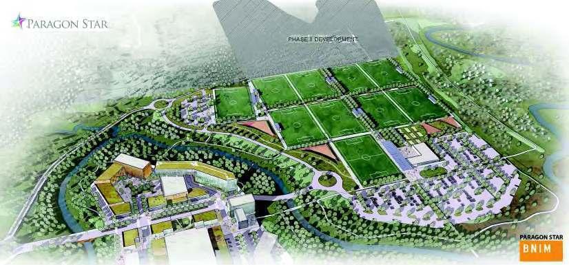
7 II. TAX INCREMENT FINANCING A. This Redevelopment Plan is adopted pursuant to the Act. The Act enables municipalities to finance Redevelopment Project Costs with the revenue generated from Payments in Lieu of Taxes and 50% of the Economic Activity Taxes. III. GENERAL DESCRIPTION OF REDEVELOPMENT PLAN AND PROJECT A. The Redevelopment Plan The Paragon Star Redevelopment Plan contemplates the development of a variety of land uses, including but not limited to, a sports complex, residential, office, hotel, retail, restaurants and general commercial. The Redevelopment Plan land area is comprised of approximately 309 acres generally located north of Interstate 470, east of View High Drive and west of Pryor Road, and a portion located along the southeast corner of the intersection of Interstate 470 and View High Drive, all within Jackson County, Lee s Summit, Missouri. The Redevelopment Plan contains three (3) proposed Redevelopment Projects Areas. Redevelopment Project Area 1 ( RPA 1 ) proposes the development of an approximately 130-acre development designed to support local community needs but, will also result in significant new tourism opportunities for Lee s Summit and the region. The project features a Sports Complex, a Mixed Use Village and a trail head to serve new hiking and biking trails. The development plan provides for the development and construction of not less than ten (10) artificial turf multi-sport fields, a 23,000 square foot clubhouse with eight (8) adjacent sand volleyball courts, and mixed use village featuring a 220 unit upscale multifamily residential project, a 90,000 square feet Class A office building, a 120 unit hotel and 79,000 square feet of retail (the Project ). The City owns approximately 76 acres of property within the boundaries of RPA 1 ( City Property ). The City issued a Request for Qualifications, RFQ No , seeking statements of qualifications from firms to prepare an illustrated conceptual development plan for City Property. Paragon Star, LLC, successor in interest to Happy Valley Properties, LLC, submitted a statement of qualifications in response to the RFQ, and was selected by City as the most qualified applicant to commence discussions with City for potential development of City Property, which may also include surrounding properties that are not owned by City. Jackson County, Missouri ( County ) owns properties immediately adjacent to the City Property and located within RPA 1. The County has expressed its willingness to allow Paragon Star, LLC to use the County Property for shared parking and trail activities. Paragon Star will enter into an agreement with the County to facilitate this relationship. In addition to the RPA 1 plan, it is acknowledged that the future development of Redevelopment Project Area 2 ( RPA 2 ) and Redevelopment Project Area 3 ( RPA 3 ) (defined herein) may create a need for additional improvements not proposed by the Redevelopment Plan. More detailed redevelopment project area plans for Project Area 2 (RPA 2) and Project Area 3 (RPA 3) will be forwarded as amendments to the Paragon Star Redevelopment Plan when those projects are ready to move forward. 7
8 B. Redevelopment Area The boundaries of the Redevelopment Area are generally depicted on Exhibit 2. The legal descriptions of the parcels comprising the Redevelopment Area are set forth in Exhibit 1-A. In the event of any inconsistency between Exhibit 1-A and Exhibit 2, Exhibit 1-A shall control. The Redevelopment Area currently includes three (3) project areas, Project Areas 1, 2 and 3. Project Area 1 is legally described in Exhibit 1-B, proposed Project Area 2 is legally described in Exhibit 1-C, and proposed Project Area 3 is legally described in Exhibit 1-D. Based upon current ownership, existing land uses and discussions between City staff and various property owners and developers as to additional development opportunities when the RPA 1 Project is constructed, it is contemplated that, in the future, additional project areas (specifically Project Area 2 and Project Area 3, as generally depicted on Exhibit 2) will be created within the Redevelopment Area. Project Areas 1, 2 and 3, in addition to any future project areas that are hereinafter approved in accordance with the Act, are referred to collectively herein as Project Areas or singularly as "Project Area". The proposed uses anticipated within the Redevelopment Area are as follows: i. Project Area 1 ( acres) - Sports Complex, Trails, and Mixed Use Village ii. iii. Project Area 2 (40.25 acres) - Office and Commercial Project Area 3 ( acres) - Commercial (including but not limited to, sports fields, hotel, retail and office uses) Note: Project Area 2 (RPA 2) and Project Area 3 (RPA 3) are not being proposed or established within this Redevelopment Plan at this time. They are presented within this Redevelopment Plan: (1) for qualification as a blighted area pursuant to Section (1) RSMo., (2) to show potential additional demands for public infrastructure, and (3) to identify additional development that can be reasonably contemplated if the RPA 1 is constructed. C. Project Improvements The Redevelopment Plan contemplates the primary application of tax increment financing revenues towards the construction of the Sports Complex component of RPA 1, and payment of eligible Redevelopment Project Costs. D. Redevelopment Plan Objectives The general objectives of the Redevelopment Plan are: i. To enhance the tax base of the City and the other Taxing Districts, and encourage private investment in the surrounding area; ii. iii. To increase employment opportunities; To increase recreational opportunities; 8
9 iv. To stimulate construction and development and generate tax revenues, including, but not limited to, real estate tax revenues, sales tax revenues, and personal property tax revenues; all of which would not occur without Tax Increment Financing assistance; and v. To increase the economic viability of this western region of the City by establishing the area as a sports and entertainment destination, stopping the leakage of spending from City residents to other commercial areas outside of the City, County, and/or State, and capturing spending from other cities. IV. FINANCING A. Estimated Redevelopment Project Costs i. RPA 1 Project Cost The total cost to construct the proposed Sports Complex and Mixed Use Village of the RPA 1 Plan is estimated at $212,000,000 as set forth on Exhibit 7. The Redevelopment Plan proposes that Redevelopment Project Costs be reimbursed from Payments in Lieu of Taxes and Economic Activity Taxes generated by the Project Areas created from time to time, together with other Public Revenue Sources (detailed below). ii. Additional Improvements In addition to the RPA 1 improvements, it is acknowledged that the future development of Project Area 2 and Project Area 3 may create a need for additional Redevelopment Project Costs to be reimbursed from Payments in Lieu of Taxes and Economic Activity Taxes generated by the Project Areas created from time to time. If additional Redevelopment Project Costs are approved to be reimbursed by an amendment to the Redevelopment Plan, such an amendment must demonstrate that there is or will be sufficient Payments in Lieu of Taxes and Economic Activity Taxes available for the reimbursement of such additional Redevelopment Project Costs. B. Anticipated Sources of Funds This Redevelopment Plan proposes that TIF Revenue bonds or other Obligations will be issued. The bond proceeds will be deposited in a special construction/project fund for use in payment of eligible Redevelopment Project Costs. Anticipated sources and amounts of funds to pay Redevelopment Project Costs are discussed below. i. Payments in Lieu of Taxes Calculations of expected proceeds of Payments in Lieu of Taxes ( PILOTS ) are based on current real property assessment formulas and current and anticipated property tax rates, both of which are subject to change due to many factors, including reassessment, the effects of real property classification for real property tax purposes, the timing of the completion of the projects within the Project Areas and the corresponding timing of their inclusion in the property tax rolls, and the rollback in tax levies resulting from reassessment or classification. The estimated total Payments in 9
10 Lieu of Taxes generated within RPA 1 the Redevelopment Area over the duration of RPA 1 Redevelopment is approximately $35,678,435. Those Payments in Lieu of Taxes are shown on Exhibit 6. A majority of the land area of RPA 1 is located within the boundaries of the Hickman Mills C-1 School District with some overlap from the Lee s Summit R-7 School District. The Jackson County, Missouri parcel tax records identity Hickman Mills C-1 as the affected school taxing district for the majority of the land area. Paragon Star will work with the school districts and the Jackson County Assessor s Office to identify and define the real property valuation to be allocated to each school district within RPA 1. All amounts shown as anticipated Payments in Lieu of Taxes are projections based on estimates prepared by Paragon Star, LLC. The estimated redevelopment project costs for RPA 1 in Exhibit 7 for the construction of the hotel, residential, office and retail development is approximately $142,000,000. The market value of these improvements, for which PILOT calculations are projected in Exhibit 6, is $56,723,000. Actual amounts generated may be greater or lesser due to variations between actual versus projected project density or market conditions. The affected Taxing Districts within the boundaries of RPA 1, will receive a portion of the PILOTS generated within RPA1 based on the following formula. The amount of real property taxes generated from post development real property values in excess of a base market value of $60,000,000 as determined by the Jackson County Assessor s Office for taxable land and improvements (not publically owned property) in RPA 1, shall be treated as follows: 50% of such incremental property tax revenues shall be declared surplus and distributed prorata to the affected taxing jurisdictions and 50% of such incremental property tax revenues shall be pledged to retirement of TIF Obligations for the term of RPA 1. When an amendment to the Redevelopment Plan is proposed to facilitate the development of RPA 2, the Redevelopment Plan amendment will not seek more than 50% of PILOTS generated within RPA 2 from the post development real property values based upon the Jackson County Assessor s Office market value for land and improvement. The TIF contract will contain appropriate provisions to implement this restriction. ii. Economic Activity Taxes The projected Economic Activity Taxes generated within RPA 1 of the Redevelopment Area and available to the Special Allocation Fund, in accordance with the Act, over the duration of RPA 1 are approximately $14,118,969 as shown in Exhibit 6. All such projected Economic Activity Taxes are anticipated to be made available, subject to annual appropriation, to pay eligible Redevelopment Project Costs. 10
11 It is assumed that sales tax revenues will increase at a rate of 1.5% a year. As with the Payments in Lieu of Taxes, all amounts shown as anticipated Economic Activity Taxes are projections based on estimates prepared by Paragon Star, LLC. Actual amounts generated may be greater or lesser due to variations between actual versus projected project density or market conditions. iii. Other Public Revenue Sources 1. Regional Transportation Development District This Redevelopment Plan proposes the Creation of a Regional Transportation Development District ( Regional TDD ) pursuant to Missouri Revised Statute Sections et seq., whose boundaries a portion of which will overlap with the Redevelopment Area. It is anticipated that such TDD will impose a sales tax, but the imposition of a sales tax shall not exceed 1% on all retail sales made within the boundaries of the TDD. Only a portion of the land area of the Regional TDD is located within the boundaries of RPA 1. It is anticipated that $0.00 Regional TDD Sales Tax revenue will be accounted for as RPA 1 EATS. Regional TDD sales tax revenue generated by the Regional TDD is estimated to, through revenue bond financing, to contribute a net $20,000,000 to fund approved Redevelopment Project Costs for transportation project costs. 2. Community Improvement District Sales Tax On December 3, 2015, the City Council enacted Ordinance No. 7762, establishing the I-470 and View High Community Improvement District ("View High CID") pursuant to Missouri Revised Statute Sections et. seq., whose boundaries are coterminous with the boundaries of RPA 1 of the Redevelopment Plan. It is anticipated the View High CID will impose a sales tax, but the imposition of a sales tax shall not exceed 1% on all retail sales made within the boundaries of the View High CID ( CID Revenue ). The revenue from the View High CID sales tax, accounted for as an EATS will be approximately $3,627, over a twenty-three (23) year period. The Redevelopment Plan proposes that revenue from the View High CID sales tax not accounted for as an EATS will be pledged for the reimbursement of Redevelopment Project Costs and will be approximately $3,627, over a twenty-three (23) year period. These revenue projections are set forth in Exhibit 6. The View High CID Revenue will be used to fund approved Redevelopment Project Costs or retire Obligations. 11
12 3. City General Obligations Bonds The qualified voters of Lee s Summit, Missouri in a past election authorized the issuance of general obligations bonds for several road improvement projects, including the allocation of $1,000,000 for road improvements at the intersection of I-470 and View High Drive (the Intersection ). This Redevelopment Plan proposes the City issuing general obligation bonds for the purpose of constructing road improvements at the Intersection, and that these general obligation bond proceeds will be used to fund approved Redevelopment Project Costs or retire Obligations related to Intersection improvements. 4. State of Missouri The Redevelopment Plan proposes that the View High CID apply for capital improvement financing from the State of Missouri utilizing several state programs which partner with political subdivisions to enhance public infrastructure. The State funds obtained by the View High CID will be used to fund approved Redevelopment Project Costs or retire Obligations related to those costs. The financing planned from the State of Missouri is approximately $20,000,000, and is allocated towards the Redevelopment Project Costs related to the Sports Complex, Little Blue Trace Walking Trails and Rock Island Railroad Trail (2 miles). These Redevelopment Project Costs are set forth in more detail in Exhibit 7. Several of the other public funding sources will require applications to and approvals by other entities, political subdivisions in state agencies, and are included in this Redevelopment Plan to set forth a general statement of the mix of intended funding sources. Any revisions to the mix of other public funding sources shall not require amendment of this Redevelopment Plan. C. Anticipated Type and Terms of Obligations It is anticipated that Obligations will be issued to finance the Redevelopment Project Costs. The Redevelopment Plan intends that these Obligations shall have, subject to annual appropriation, a first lien on the Payments in Lieu of Taxes and Economic Activity Taxes revenue stream. Revenues received in excess of 100% of funds necessary for the payment of principal and interest on the Obligations may be used for reserves, eligible Redevelopment Project Costs or to call Obligations in advance of their maturities; provided that, of the Payments in Lieu of Taxes revenue stream in excess of the amounts needed to market Obligations, such revenues shall be treated as follows: 50% of such excess Payment in Lieu of Taxes Revenue shall be declared surplus and distributed pro rata to the affected taxing jurisdictions and 50% of such excess Payments in Lieu of Taxes Revenue shall be pledged to the retirement of TIF Obligations for the term of the RPA 1. Obligations may be sold in one or more series in order to implement this Redevelopment Plan. All Obligations shall be retired no later than twenty-three (23) years after the adoption of the ordinance adopting tax increment financing for a specific Project Area, which supports 12
13 such Obligations, the costs of which are to be paid from the proceeds thereof. No Redevelopment Project may be approved by ordinance adopted more than ten years from the adoption of the ordinance approving the Redevelopment Plan under which such Redevelopment Project is authorized. D. Evidence of Commitments to Finance The Redevelopment Plan will be financed through several revenue sources, including private financing. Attached as Exhibit 12 is a letter from financial institutions, evidencing this commitment to finance. V. EQUALIZED ASSESSED VALUATION A. Most Recent Equalized Assessed Valuation The total initial equalized assessed valuation of the Redevelopment Area, RPA 1, according to current records at the Jackson County Assessor's Office, is approximately $80,885. The taxable portion of that assessed valuation, that being property held by non-public entities, is $27,833. The current combined ad valorem property tax levy is projected to be $ per $100 assessed valuation. The 2015 annual ad valorem tax revenue from the Project Areas will be approximately $3,016. The initial equalized assessed valuation is further detailed on Exhibit 6. The Total Initial Equalized Assessed Valuation of each Project Area within the Redevelopment Area will be determined prior to the time such Project Area is approved by ordinance. Payments in Lieu of Taxes measured by subsequent increases in property tax revenue which would have resulted from increased valuation had Tax Increment Financing not been adopted will be segregated from taxes resulting from the Total Initial Equalized Assessed Valuation as defined herein, and deposited in the Special Allocation Fund earmarked for payment of Redevelopment Projects Costs as defined herein. B. Estimated Equalized Assessed Valuation after Redevelopment When the RPA 1 Project improvements have been completed, the total assessed valuation of the RPA 1 Redevelopment Area will be determined. Should RPA1 develop pursuant to existing development plans provided by private developers at the time of the submission of this Redevelopment Plan, and pursuant to projections provided to the City by its consultants, future equalized assessed valuation for RPA1 is estimated to total approximately $15,551,360. Based upon those projections and plans, it is projected that the future increase in equalized assessed valuation for the Project Areas due to the redevelopment and taking into consideration that a portion of RPA 1 will remain tax exempt through public ownership, will total approximately $15,551,360. Detailed calculations showing the estimated increase in assessed valuation and the resulting Payments in Lieu of Taxes are shown in Exhibit 6. VI. GENERAL LAND USE A. Exhibit 2 details the proposed land use categories in the portions of the Redevelopment Area in which (1) RPA 1 is located, and (2) it is anticipated that additional future development is likely to occur, including office and commercial uses in Project Area 2 13
14 and 3. The development of RPA 1 will necessitate rezoning, preliminary development plan, final development plan, and platting applications, with development progressing in compliance with the applicable provisions of the City s CP-2 and /or PMIX zoning districts. It is anticipated that such land use applications will occur before development commences. VII. REQUIRED STATUTORY FINDINGS A. Existing Conditions in Redevelopment Area The Blight Analysis ("Blight Study") was prepared by Development Initiatives on September 11, 2013, and updated through a Reliance Letter, dated December 16, 2015, both documents of which are attached as Exhibit 4. To meet the statutory definition of blight, a minimum of one blight factor out of five must be found to be present in the Redevelopment Area. Statutory blight factors, as summarized in the Blight Study, include the following: i. Factor 1: Defective or inadequate street layout; ii. iii. Factor 2: Unsanitary or unsafe conditions; and Factor 3: Deterioration of Site Improvements. The Blight Study finds that the Redevelopment Area qualifies as a "blighted area" due to the presence of three (3) factors and provides the evidence of blight as stated within the Redevelopment Act in Section (1) RSMo, the specifics of which may be reviewed in Exhibit 4. B. Expectations for Development The Redevelopment Area, taken as a whole, has not been subject to growth and development by private enterprise and would not reasonably be anticipated to be redeveloped without the adoption of the Redevelopment Plan. Paragon Star, LLC has provided a Developer s Affidavit which reflects this circumstance attached as Exhibit 11. Due to the extraordinary costs required to remediate the blighting factors found in the Blight Study, most notably the lack of sufficient roadway infrastructure and lack of a sufficient interchange to handle the levels of traffic necessary to support commercial uses, and undermined conditions, the property within the Redevelopment Area has not been subject to growth or development. Providing Tax Increment Financing assistance for this project allows the remediation of this blight. C. Conforms to Comprehensive Plan of City The Redevelopment Plan is generally consistent with the Lee's Summit Comprehensive Plan. The Comprehensive Plan mentions a desire on the part of the City to use programs like Tax Increment Financing to create quality commercial developments. The Comprehensive Plan also promotes: i. The creation of community and neighborhood activity centers at or near the City's major highway and roadway interchanges/intersections; ii. An increase in business opportunities in the City; 14
15 iii. iv. The prevention of under-utilization or waste of the City's land resources; and Convenient services and shopping. The Redevelopment Plan directly addresses the concerns and desires voiced in the Comprehensive Plan. D. Date to Approve Redevelopment Projects In no event shall any ordinance approving a Redevelopment Project be adopted later than ten (10) years from the adoption of the ordinance approving this Redevelopment Plan. E. Date to Complete Redevelopment The redevelopment of the RPA 1 is projected to be completed by June The Estimated Redevelopment Schedule is attached as Exhibit 5. The varied public revenue sources create an opportunity for phased financing for the sequential development of the Project which provides for better financial management of Redevelopment Project Cost expenditures. For instance, the capital replacement fund for the Sports Complex fields may be funded at the completion of Sports Complex construction, rather than at the commencement of the Project. F. Date to Retire Obligations The completion of each Redevelopment Project and retirement of Obligations incurred to finance Redevelopment Costs will occur no later than twentythree (23) years from the adoption of the ordinance approving such Redevelopment Project. G. Acquisition by Eminent Domain The City Council may, by separate action and in its sole discretion, exercise the power of eminent domain to carry out the objectives of the Redevelopment Plan. H. Relocation Assistance For relocation of eligible displaced occupants and businesses, if any, in the Redevelopment Area, the City will adhere to the Relocation Assistance program detailed in Exhibit 13. I. Cost-Benefit Analysis A cost-benefit analysis has been prepared for the Redevelopment Plan. This analysis and other evidence submitted to the Commission describe the fiscal impact on every affected Taxing District and provide sufficient information to determine that the project as proposed is financially feasible; the Cost-Benefit Analysis can be found on Exhibit 6. J. Gambling Establishment The Redevelopment Plan does not include the development or redevelopment of any Gambling Establishment. 15
16 Tax Increment Financing Plan Exhbit Index Exhibit 1-A Legal Description of Redevelopment Area Exhibit 1-B Legal Description - Project Area 1 Exhibit 1-C Legal Description - Project Area 2 Exhibit 1-D Legal Description - Project Area 3 Exhibit 2 Exhibit 3 Exhibit 4 Exhibit 5 Redevelopment Area Boundries & Project Area Boundries Site Plan & Elevations Development Initiatives: Reliance Letter & Blight Analysis Estimated Redevelopment Schedule Exhibit 6 Cost Benefit Analysis for RPA 1 Exhibit 7 Exhibit 8 Exhibit 9 Exhibit 10 Exhibit 11 Exhibit 12 Exhibit 13 Estimated Project Budget Sources and Uses Land Acquisition Map & Parcel Ownership Developers Proposal Developers Affidavit Evidence of Commitment to Finance Relocation Assistance
17 Exhibit 1-A: Legal Description Redevelopment Area Page: 1 TIF Legal Description: A tract of land situated in the Southwest Quarter, Northwest Quarter and Northeast Quarter of Section 34, and the South Half of the North Half of Section 35, Township 48 North, Range 32 West, in Lee s Summit, Jackson County, Missouri being more particularly described as follows: Parcel No Owner: Jackson County, MO Parcel No Owner: Happy Valley Properties, LLC Parcel No Owner: Happy Valley Properties, LLC Parcel No Owner: Happy Valley Properties, LLC Parcel No Owner: Happy Valley Properties, LLC Parcel No Owner: Jackson County, MO Parcel No Owner: City of Lee s Summit, MO Parcel No Owner: Jackson County, MO Parcel No Owner: City of Lee s Summit, MO Beginning at the Southwest corner of the Northwest Quarter of said Section 34; thence North East, along the West line of said Quarter, a distance of feet, to the Northwest Corner of said Quarter; thence South East, departing said West line, and along the North line of said Quarter, a distance of feet, to a point on the West line of the Kansas City Rock Island Railway right-of-way as recorded in Book 244, Page 79 in the recorder s office of Jackson County, Missouri, as now established; thence South West, departing said North line, and along said West right-of-way line, a distance of feet to a point of curvature; thence Southerly, continuing along said West right-of-way, and along a curve to the left,
18 Exhibit 1-A: Legal Description Redevelopment Area Page: 2 having a radius of feet, and a central angle of , a distance of feet, to a point of tangency; thence South East, continuing along said West right-of-way line, a distance of feet; thence South East, continuing along said right-of-way line, a distance of feet, thence South East, continuing along said right-of-way line, a distance of feet, to a point on the East line of said Quarter; thence South West, continuing along said West right-of-way line, and along said East line, a distance of feet, to a point on the North right-of-way line of Interstate Route 470, as now established; thence departing said West right-of-way line and said East line, and along said North right-ofway line the following courses; North West, a distance of feet; thence North West, a distance of feet; thence South West, a distance of feet, to a point on the West line of the Southeast Quarter of said Quarter; thence South West, departing said North right-of-way line, and along said West line of the Southeast Quarter, a distance of feet, to a point on the South right-of-way line of Interstate Route 470, as now established; thence departing said West line of the Southeast Quarter, and along said South right-of-way line the following courses; North West, feet; thence North West, feet; thence South West, feet; thence South West, feet; thence South West, feet, to a point on the West line of the Southwest Quarter of said Section 34; thence North East, along said West line, a distance of feet to the Point of Beginning. ALSO all that part of the Kansas City Rock Island Railway right-of-way as recorded in Book 244, Page 79 in the recorder s office of Jackson County, Missouri, lying in the North Half of said Section 34, and North of the North right-of-way line of Interstate Route 470, as now established. AND ALSO: Parcel No Owner: Happy Valley Properties, LLC Parcel No Owner: Happy Valley Properties, LLC Parcel No Owner: Happy Valley Properties, LLC Commencing at the Northwest corner of the Southwest Quarter of said Section 34: thence South West, along the West line of said Southwest Quarter, a distance of feet to a point on the South right-of-way line of Interstate Route 470, as now established; thence departing said West line, and along said South rightof-way line the following courses; North East, feet; thence North East, feet; thence North East, feet; thence South
19 Exhibit 1-A: Legal Description Redevelopment Area Page: East, feet; thence South East, feet, to a point on the East line of the Southwest Quarter of the Northwest Quarter of said Section 34; thence South West, departing said South right-of-way line, and along said East line, a distance of feet, to the Southeast corner of the said Quarter Quarter; thence South West, along the East line of the Northwest Quarter of the Southwest Quarter, a distance of feet, to the Southeast corner of said Quarter Quarter; thence North West, departing said East line of the Northwest Quarter of the Southwest Quarter, and along the South line of said Quarter Quarter, a distance of feet, to the Northeast corner of Lot 2, Berkman Estates, a Subdivision in said City, County and State; thence South West, departing said South line of said Quarter Quarter, and along the East line of said Lot 2, a distance of feet, to the Southeast corner of said Lot 2, said corner also being the Northeast corner of Lot 3 of said Subdivision; thence North West, departing said East line of said Lot 2, and along the North line of said Lot 3, a distance of feet, to the Northwest corner of said Lot 3; thence South West, departing said North line of Lot 3 and along the West line of said Lot 3, a distance of feet, to the Southwest corner of said Lot 3, said corner also being on the Northerly right-of-way line of Chipman Road, as now established; thence Southwesterly, departing said West line of Lot 3, and along said Northerly right-of-way line of Chipman Road, and along a curve to the left, having a radius of feet, a central angle of , and whose initial tangent bearing is South West, a distance of feet; thence South West, continuing along said Northerly right-of-way line of Chipman Road, a distance of 9.51 feet, to the Southeast corner of Lot 1 in said Subdivision; thence North East, departing said Northerly right-of-way line of Chipman Road, and along the East line of said Lot 1, a distance of feet, to the Northeast corner of said Lot 1; thence North West, departing said East line of Lot 1, and along the North line of said Lot 1, a distance of feet, to the Northwest corner of said Lot 1, said point also being the Southwest corner of said Lot 2; thence North East, departing said North line of Lot 1, and along the West line of said Lot 2, a distance of feet, to the Northwest corner of said Lot 2; thence North West, departing said West line of Lot 2, and along the South line of the Northwest Quarter of the Southwest Quarter, a distance of feet, to the Southwest corner of said Quarter Quarter; thence North East, departing said South line, and along the West line of said Quarter Quarter, a distance of feet; thence Northeasterly, departing said West line, and along a curve to the right, having a radius of feet, a central angle of , and whose initial tangent bearing is North East, a distance of feet; thence North East, a distance of feet; thence Northerly, along a curve to the left, having a radius of feet, and a central angle of , a distance of feet; thence North West, a distance of feet; thence Northwesterly, along a curve to the left, having a radius of feet, and a central angle of , and whose initial tangent bearing is North West, a distance of feet; thence South West, a distance of feet; thence Westerly, along a curve to the right, having a radius of feet, a central angle of , and whose initial tangent bearing is South
20 Exhibit 1-A: Legal Description Redevelopment Area Page: 4 West, a distance of feet; thence South West, a distance of feet; thence North West, a distance of 8.10 feet, to the West line of said Quarter Quarter; thence North East, along the West line of said Quarter Quarter, a distance of feet, to the Point of Beginning. AND ALSO: Parcel No Owner: Jackson County, MO All that part of the West ½ of the Northeast ¼ of Section 34, Township 48, Range 32, in Lee s Summit, Jackson County, Missouri, described as follows: Beginning at the Northwest corner of the Northeast ¼ of Section 34, Township 48, Range 32, and running thence South 99 poles ( feet); thence North 55 ½ East 26 poles (429 feet); thence North 4 East 18 poles (297 feet); to a corner in the Little Blue River; thence South 88 East 24 poles (396 feet); thence South 39 East 24 poles (396 feet); thence North 49 1/2 East 23.2 poles (382.8 feet) to the East line of the West ½ of said ¼ section; thence North 70 poles (1155 feet); thence West 80 poles (1320 feet) to beginning, except the Chicago, Rock Island and Pacific Railway right-of-way, all being in Jackson County, Missouri, containing 30.4 acres, more or less. AND ALSO: Parcel No Owner: Jackson County, MO All that part of the West ½ of the Northeast ¼ of Section 34, Township 48, Range 32, in Lee s Summit, Jackson County, Missouri, described as follows: Beginning at a point on the West line of said ¼ Section that is 99 poles ( feet) South of the Northwest corner thereof; thence North 55 degrees 30 minutes East 26 poles (429 feet); thence North 4 East, 18 poles (297 feet) to a corner in the Little Blue River; thence South 88 degrees East 24 poles (396 feet); thence South 39 degrees East 24 poles (396 feet); thence South 47 degrees West 24 poles (396 feet); thence South 72 degrees 30 minutes West 16 poles (264 feet); thence South 5 degrees 30 minutes West 380 feet, more or less to the North right of way line of Interstate Route 470, as now established; thence West along said right of way line 460 feet, more or less to the West line of said ¼ section; thence North to the point of beginning. EXCEPTING any part in the Union Pacific Railroad recorded in Book 244, Page 79 and Book 244, Page 193 in the recorder s office of Jackson County, Missouri.
21 Exhibit 1-A: Legal Description Redevelopment Area Page: 5 AND ALSO: Parcel No Owner: Kenneth L & S Kay Gerdts A tract of land situated in the West ½ of the Northeast ¼ of Section 34, Township 48, Range 32, in Lee s Summit, Jackson County, Missouri being more particularly described as follows: Commencing at the Northeast corner of said Northeast ¼; thence North West, along the North line of said Northeast ¼, feet to the Northeast corner of the West Half, of said Northeast ¼; thence South West, along the East line of said West Half, feet to the Northeast corner of the Southwest ¼ of said Northeast ¼, said corner being the Point of Beginning of the tract to be described herein; thence South West, continuing along said East line; feet to the Northerly right-of-way line of Highway I-470; thence North West, along said line, feet from and parallel with the centerline thereof, 0.51 feet to a point opposite centerline station ; thence North West, continuing along said line, feet to a point feet from and opposite centerline station ; thence North West, continuing along said line, feet from and parallel with the centerline thereof, feet to a point opposite centerline station ; thence South West, continuing along said line, feet to a point feet from and opposite centerline station ; thence North West, continuing along said line, feet from and parallel with the centerline thereof, feet to the East line of a Tract described in a warranty deed recorded in Book 1123 at Page 1716 in the recorder s office of Jackson County, Missouri; thence North East, along said line, feet (deed = ±380 ); thence North East, feet; thence North East, feet; thence North East, feet to a point on the East line of the West Half of said NE ¼; said point being South West, along said line, feet (deed = ) from the Northeast corner of said West Half; thence South West, along said line, feet to the Point of Beginning. Containing 510,195 square feet or acres, more or less. AND ALSO: Parcel No Owner: The Family Ranch, LLC The North half of the Southeast Quarter of the Northeast Quarter of Section 34, Township 48, Range 32, Lee s Summit, Jackson County, Missouri, except that part in roads.
22 Exhibit 1-A: Legal Description Redevelopment Area Page: 6 AND ALSO: Parcel No Owner: Jerry D & Deia S Rank The Southwest Quarter of the Southeast Quarter of the Northeast Quarter of Section 34, Township 48, Range 32, EXCEPTING all that part South of the North R/W line of Interstate Route 470 by Suit No in the Circuit Court of Jackson County, Missouri. AND ALSO: Parcel No Owner: Brinton, George C. The Southeast Quarter of the Southeast Quarter of the Northeast Quarter of Section 34, Township 48, Range 32, EXCEPTING all that part South of the North R/W line of Interstate Route 470 by Suit No in the Circuit Court of Jackson County, Missouri. AND ALSO: Parcel No Owner: Captain Fancy Two, LLC Part of the Southwest Quarter of the Northwest Quarter of Section 35, Township 48 North, Range 32 West in Lee's Summit, Jackson County, Missouri, more particularly described as follows: Beginning at the Northwest corner of said Quarter Quarter Section; thence South 86 degrees 36 minutes 33 seconds East along the North line of said Quarter Quarter Section, a distance of feet to a point being feet Westerly of the East line of said Quarter Quarter Section; thence South 02 degrees 29 minutes 11 seconds West (South 03 degrees 00 minutes 16 seconds West-Deed) parallel with the East line of the Southwest Quarter of the Northwest Quarter of said Section 35, a distance feet to a point on the existing North right of way line of I-470 Highway; thence North 85 degrees 08 minutes 16 seconds West (North 85 degrees 02 minutes 17 seconds West-Deed) along said existing North right of way line, a distance of feet ( feet-deed) to a point being 150 feet left of Highway Station ; thence North 78 degrees 00 minutes 46 seconds West (North 77 degrees 54 minutes 47 seconds West-Deed) continuing along said existing North right of way line of I-470 Highway, a distance of feet to a point being 175 feet left of Highway Station ; thence North 85 degrees 08 minutes 16 seconds West (North 85 degrees 02 minutes 17 seconds West-Deed) continuing
23 Exhibit 1-A: Legal Description Redevelopment Area Page: 7 along said existing North right of way line of I-470 Highway, a distance of feet ( feet-deed) to a point on the West line of said Quarter Quarter Section; thence North 02 degrees 36 minutes 11 seconds East (North 02 degrees 37 minutes 26 seconds East-Deed) along said West line, a distance of feet ( feet- Deed) to the point of beginning. AND ALSO the East feet of said Quarter Quarter, bounded on the South by the North R/W line of Interstate Route 470 by Suit No in the Circuit Court of Jackson County, Missouri, and bounded on the North by the Westerly extension of the South line of a Tract described in a warranty deed recorded in Book 1123 at Page 1716 in the recorder s office of Jackson County, Missouri. AND ALSO: Parcel No Owner: The Family Ranch, LLC All that part of Section 35, Township 48, Range 32, In Lee's Summit, Jackson County, Missouri, described as follows: From the center of said Section 35, run South 43 rods (709.5 feet); thence North 75 degrees West 9 rods (148.5 feet) to the point of beginning of the tract described herein; thence North 30 degrees East 97 rods ( feet); thence North 58 degrees West 44-3/4 rods ( feet); to the East line of the Southeast 1/4 of the Northwest 1/4 of said Section 35; thence North along said East line 10 rods (165 feet) to the Northeast corner of said 1/4 1/4 section; thence West along the North line of said 1/4 1/4 section 970 feet; more or less to a point 350 feet East of the Northwest corner of said 1/4 1/4 section; thence South parallel with the West line of said 1/4 1/4 section 124 feet; thence West parallel with the North line of said 1/4 1/4 section 350 feet to the West line of said 1/4 1/4 section; thence South along said West line, feet to a point feet South of the Northwest corner of the Northeast 1/4 of Southwest 1/4 of said Section 35; thence East parallel with the North line of said 1/4 1/4 section, feet; thence South parallel with the West line of said 1/4 1/4 section, feet to a point in a line bearing South 75 degrees East end passing through the point of beginning, thence South 75 degrees East along said line to the point of beginning EXCEPTING that part described as follows: All that part of the Southeast Quarter of the Northwest 1/4 of Section 35, Township 48, Range 32, described as follows: Beginning at a point 124 feet South of the Northwest corner of said Quarter Quarter Section; thence East 350 feet; thence South 124 feet; thence West 350 feet to the West line of said Quarter Quarter Section; thence North 124 feet to the point of beginning. Also EXCEPTING all that part South of the North R/W line of Interstate Route 470 by Suit No in the Circuit Court of Jackson County, Missouri.
24 Exhibit 1-A: Legal Description Redevelopment Area Page: 8 AND ALSO: Parcel No Owner: The Family Ranch, LLC A tract of land in the Southwest Quarter of the Northeast Quarter of Section 35, Township 48, Range 32, City of Lee's Summit, Jackson County, Missouri, more particularly described as follows: Commencing at the Southwest corner of the Northeast Quarter of said Section 35; thence South 86 degrees 35 minutes 26 seconds East along the South line of said Northeast Quarter Section, a distance of feet to the Southeast corner of the Southwest Quarter of said Northeast Quarter Section, thence North 2 degrees 28 minutes 04 seconds East along the East line of the Southwest Quarter of said Northeast Quarter Section and parallel with the West line of said Northeast Quarter Section, a distance of feet ( feet Deed); thence North 52 degrees 58 minutes 43 seconds West, a distance of feet (North 53 degrees 45 minutes 21 seconds West, a distance of feet Deed) to a point on the North right of way line of Interstate No. 470 as now established, said point being the point of beginning; thence continuing North 52 degrees 58 minutes 43 seconds West, a distance of feet (North 53 degrees 45 minutes 21 seconds West, a distance of feet Deed); thence South 33 degrees 03 minutes 26 seconds West, a distance of feet (South 31 degrees 23 minutes 25 seconds West, a distance of feet, Deed) to a point on the North right of way line of said Interstate 470; thence South 84 degrees 53 minutes 05 seconds East, a distance of feet (South 85 degrees 06 minutes 10 seconds East along said North Highway right of way line, a distance of feet, Deed); thence North 87 degrees 59 minutes 25 seconds East, a distance of feet (North 87 degrees 46 minutes 20 seconds East along said North right of way line, a distance of feet, Deed); thence South 84 degrees 53 minutes 05 seconds East, a distance of feet (South 85 degrees 06 minutes 10 seconds East along said North right of way line, a distance of feet, Deed); to the point of beginning, subject to that part thereof in roads.
25
26
27
28
29 Exhibit 1-D: Legal Description of Project Area 3 Page: 1 East 26 poles (429 feet); thence North 4 East 18 poles (297 feet); to a corner in the Little Blue River; thence South 88 East 24 poles (396 feet); thence South 39 East 24 poles (396 feet); thence North 49 1/2 East 23.2 poles (382.8 feet) to the East line of the West ½ of said ¼ section; thence North 70 poles (1155 feet); thence West 80 poles (1320 feet) to beginning, except the Chicago, Rock Island and Pacific Railway right-of-way, all being in Jackson County, Missouri, containing 30.4 acres, more or less. 26 poles (429 feet); thence North 4 East, 18 poles (297 feet) to a corner in the Little Blue River; thence South 88 degrees East 24 poles (396 feet); thence South 39 degrees East 24 poles (396 feet); thence South 47 degrees West 24 poles (396 feet); thence South 72 degrees 30 minutes West 16 poles (264 feet); thence South 5 degrees 30 minutes West 380 feet, more or less to the North right of way line of Interstate Route 470, as now established; thence West along said right of way line 460 feet, more or less to the West line of said ¼ section; thence North to the point of beginning. EXCEPTING any part in the Union Pacific Railroad recorded in Book 244, Page 79 and Book 244, Page 193 in the recorder s office of Jackson County, Missouri.
30 Exhibit 1-D: Legal Description of Project Area 3 Page: 2 Owner: Kenneth L & S Kay Gerdts A tract of land situated in the West ½ of the Northeast ¼ of Section 34, Township 48, Range 32, in Lee s Summit, Jackson County, Missouri being more particularly described as follows: Commencing at the Northeast corner of said Northeast ¼; thence North West, along the North line of said Northeast ¼, feet to the Northeast corner of the West Half, of said Northeast ¼; thence South West, along the East line of said West Half, feet to the Northeast corner of the Southwest ¼ of said Northeast ¼, said corner being the Point of Beginning of the tract to be described herein; thence South West, continuing along said East line; feet to the Northerly right-of-way line of Highway I-470; thence North West, along said line, feet from and parallel with the centerline thereof, 0.51 feet to a point opposite centerline station ; thence North West, continuing along said line, feet to a point feet from and opposite centerline station ; thence North West, continuing along said line, feet from and parallel with the centerline thereof, feet to a point opposite centerline station ; thence South West, continuing along said line, feet to a point feet from and opposite centerline station ; thence North West, continuing along said line, feet from and parallel with the centerline thereof, feet to the East line of a Tract described in a warranty deed recorded in Book 1123 at Page 1716 in the recorder s office of Jackson County, Missouri; thence North East, along said line, feet (deed = ±380 ); thence North East, feet; thence North East, feet; thence North East, feet to a point on the East line of the West Half of said NE ¼; said point being South West, along said line, feet (deed = ) from the Northeast corner of said West Half; thence South West, along said line, feet to the Point of Beginning. Containing 510,195 square feet or acres, more or less.
31 Exhibit 1-D: Legal Description of Project Area 3 Page: 3 Owner: Jerry D & Deia S Rank Owner: Brinton, George C. Owner: Captain Fancy Two, LLC
32 Exhibit 1-D: Legal Description of Project Area 3 Page: 4 a Tract described in a warranty deed recorded in Book 1123 at Page 1716 in the recorder s office of Jackson County, Missouri.
33 Exhibit 1-D: Legal Description of Project Area 3 Page: 5

34

35
36
37 December 16, 2015 Mr. Phillip Short Paragon Star, LLC 801 NW Commerce Drive Lee s Summit, Missouri Re: Reliance Letter, View High Green Tax Increment Financing Area Blight Analysis, Lee s Summit, Missouri Dear Mr. Short: Concerning the Blight Analysis for the View High Green Tax Increment Financing Area, please be advised that Paragon Star, LLC; Happy Valley Properties, LLC, The City of Lee s Summit, Missouri and The Tax Increment Financing Commission of Lee s Summit, Missouri and any successors and assigns, and other partners, involved with the development of any properties located within the proposed boundaries of the proposed View High Green Tax Increment Financing Plan can rely on the Blight Analysis previously completed by Development Initiatives and dated September 11, Of particular note; 1. The proposed Redevelopment Boundaries have not changed. Please refer to Exhibit A Redevelopment Area Map. 2. The original report was addressed to Happy Valley Properties, LLC at 801 NW Commerce Drive, Lee s Summit, Missouri Happy Valley Properties has been reconstituted as Paragon Star, LLC with the same ownership as before. 3. Since the issuance of the original analysis no substantial activities have occurred which remedied any blighting factors identified within the original analysis. There are certain land reclamation rock excavation activities occurring presently at the eastern end of the Redevelopment Area on property parcels 16, 19, 20 & 21. These activities are minimal and will ultimately remediate the blighting conditions resulting from the under-mined portion of the Redevelopment Area. However, to-date no substantial activities have occurred which would impact or alter our original findings and all previously identified blighting factors currently exist. 140 Walnut Street, Suite 203 Kansas City, Missouri, 64106
38 4. Since the issuance of our original report several property ownership changes have occurred. These include; a. Parcel #15 has changed ownership. The new owner is listed as: Kenneth & Kay Gerdts, 2750 NW Clifford Road, Lee s Summit, Missouri. b. Parcels #16, 21 and 22. Ownership address for the owner; The Family Ranch, LLC has changed to 2301 NW Quarry Park Road, Lee s Summit, Missouri. c. Parcel 19. Ownership address for the owner, Captain Fancy Two, LLC has changed to 2501 NW Clifford Road, Lee s Summit, Missouri. 5. Furthermore; the City of Lee s Summit recently approved the I-470 & View High Community Improvement District (CID) on December 3, The approval of the CID included a finding of blight for the area as defined in Section (3) of the Revised Statutes of Missouri. The finding of blight found that the area was characterized by; Defective or Inadequate Street Layout; Insanitary or Unsafe Conditions; Improper Subdivision or Obsolete Platting; and the Existence of Conditions which Endanger Life or Property by Fire or other causes. The CID incorporated property Parcels #4 thru 12 of the originally defined Redevelopment Area. A map of the approved CID area is included as Exhibit B. 6. All blighting factors identified within the proposed Redevelopment Area continue to exist. a. Inadequate Street Layout. Poor vehicular access in and around the Redevelopment Area continues to exist. There is a continued lack of internal circulation within the Redevelopment Area and limited points of ingress/egress for vehicular access, particularly emergency vehicles. On existing roads within the Redevelopment Area, conditions exist which limit sight lines and contribute to insufficient lighting and unsafe road conditions for vehicles and pedestrians. These conditions identified in the original report have not been remedied and continue to exist. b. Unsanitary or Unsafe Conditions. A significant percentage of the Redevelopment Area is impacted by an abandoned, out-of-service 140 Walnut Street, Suite 203 Kansas City, Missouri, 64106
39 underground quarry. This abandoned mine is approximately 119 acres in size and exists on both the north and south sides of Interstate 470 (I-470). Portions of the mine are un-secured and numerous locations exist where mine roof systems are collapsing. These conditions identified in the original report have not been remedied and continue to exist. c. Deterioration of Site Improvements. Based on existing conditions within the Redevelopment Area, deteriorated site improvements primarily revolve around the unsecured, abandoned mine facility. In its existing condition, the mine facility is rapidly deteriorating due to groundwater infiltration, ceiling deterioration and antiquated design. Utilities to the mine are non-existent rendering access and use extremely hazardous. These conditions identified in the original report have not been remedied and continue to exist. In conclusion, based on our previous findings and the fact that no activities have been undertaken to remedy blighting factors within the proposed Redevelopment Area, it is our opinion that the area continues to qualify as a blighted area as defined by Section (1) of the Revised Statutes of Missouri. If you have any questions, please feel free to contact me at or at jpotter@dikc.com. Sincerely, Jim Potter Development Initiatives Partner 140 Walnut Street, Suite 203 Kansas City, Missouri, 64106
40 Exhibit A Redevelopment Area Map 140 Walnut Street, Suite 203 Kansas City, Missouri, 64106

41 Exhibit B CID Boundary 140 Walnut Street, Suite 203 Kansas City, Missouri, 64106
42 Blight Analysis: VIEW HIGH GREEN TAX INCREMENT FINANCING PLAN LEE S SUMMIT, MISSOURI PREPARED FOR: HAPPY VALLEY PROPERTIES, LLC 801 NW COMMERCE DRIVE LEE S SUMMIT, MISSOURI PREPARED BY: DEVELOPMENT INITIATIVES 140 WALNUT, SUITE 203 KANSAS CITY, MISSOURI PHONE : FAX: PREPARED: September 11,
43 TABLE OF CONTENTS Letter of Transmittal Table of Contents 1: Property Data Introduction Function of Study Purpose of Study Effective Date of Report Definition Site Description Existing Improvement Description Ownership 2: Blight Analysis Blight Analysis EXHIBITS Exhibit A: Exhibit B: Exhibit C: Exhibit D: Ownership Information/Legal Descrip. Photo Log Property Inspection Form Certification, Assumptions and Limiting Conditions, Consultant Qualifications 2
44 September 11, 2013 Happy Valley Properties, LLC 801 NW Commerce Drive Lee s Summit, Missouri Subject: Blight Study View High Green Tax Increment Financing Plan Dear Sir/Madam: We are pleased to transmit the attached Blight Study Report that has been prepared for the above referenced property. The purpose of this Report is to determine whether the subject property is blighted, as defined in Section (1) Revised Statutes of Missouri. This analysis represents an accumulation of our findings based on research and investigations performed as of the report s effective date, September 11, The attached report sets forth the data, research, investigations, analyses, and conclusions for this report. The subject Redevelopment Area is composed of twenty-one (21) parcels of land containing approximately 309 acres. Presently, the subject properties are largely composed of undeveloped property with scattered improvements. A significant portion of the Redevelopment Area is located above an out-of-service, under-ground mine. As determined in the following study, it is our opinion that the subject property represents a blighted area which is defined in Missouri Statute Section (1). The primary blighting factors include: Inadequate Street Layout, Unsanitary or Unsafe Conditions, Deterioration of Site Improvements, Economic Liability/Under Utilization. We have concluded these facts based on the current condition of the Redevelopment Area, general access and visibility of the area, and the existing conditions under the context of the anticipated development within the Redevelopment Area. Please feel free to contact me if you have any questions or comments. Sincerely, James Potter, AICP, LEED GA development initiatives 3
45 Copyright Statement This document was prepared for the intended use of Happy Valley Properties, LLC, and the Tax Increment Financing Commission of Lee s Summit, Missouri for its consideration of the Happy Valley Tax Increment Financing Plan. With the exception of the unlimited use by Happy Valley Properties, LLC, and the Tax Increment Financing Commission of Lee s Summit, Missouri, no part of this document may be reproduced, duplicated, or transmitted by mechanical, digital, or other means without permission in writing from Development Initiatives. Development Initiatives, retains all copyrights to the material located within this document and the material located herein is subjected to the U.S. Copyright Law found in the United States Code, Title 17, Chapter Copyright DI
46 Limiting Conditions The reported analysis, opinions, and conclusions contained herein are limited only by the reported assumptions and limiting conditions and are Development Initiatives unbiased professional analyses, opinions, and conclusions. Information provided and utilized by various secondary sources is assumed to be accurate. Development Initiatives cannot guarantee information obtained from secondary sources. Such information and the results of its application within this analysis are subject to change without notice. The nature of real estate development is unpredictable and often tumultuous. Development Initiatives deems our projections as reasonable considering the existing market and various obtained information. It should be understood that fluctuations in local, regional, and/or national economies could have substantial effects on the particular findings and recommendations contained within this document. Copyright DI
47 Introduction The purpose of this analysis is to investigate and determine whether blighting conditions exist at the subject property according to Section (1) of the Revised Statutes of Missouri (RSMo). The Redevelopment Area is generally located north and south of Interstate 470 and east of View High Drive in Jackson County, Lee s Summit, Missouri. The Redevelopment Area will be composed of twenty-one (21) parcels of land containing approximately 309 acres. Please refer to Exhibit A for complete ownership information for the Redevelopment Area. Function of Study This Blight Analysis has been prepared for use in conjunction with an application for tax increment financing pursuant to Missouri Revised Statutes Chapter 99 Real Property Tax Increment Allocation Redevelopment Act. Purpose of Study The purpose of this Blight Analysis is to determine whether the specific Redevelopment Area is blighted within the meaning of Section (1) RSMo. Effective Date of Report The effective date of this Blight Analysis is September 11, Unless otherwise stated, all factors pertinent to a determination of blight were considered as of that date. Copyright DI
48 Definition: In determining whether the defined Redevelopment Area is blighted, we first must define the term blighted area. For the purposes of this study, the definition found in Section (1) RSMo. Is utilized. This section provides that blighted area shall mean: Blighted Area, an area which, by reason of the predominance of defective or inadequate street layout, unsanitary or unsafe conditions, deterioration of site improvements, improper subdivision or obsolete platting, or the existence of conditions which endanger life or property by fire and other causes, or any combination of such factors, retards the provision of housing accommodations or constitutes an economic or social liability or a menace to the public health, safety, morals, or welfare in its present condition and use; This analysis will determine whether the proposed Redevelopment Area meets the statutory requirements to be declared a blighted area under the above-mentioned provision. In determining whether the Redevelopment Area is blighted pursuant to the statutory definition, Development Initiatives first reviewed the Redevelopment Area as a whole, particularly reviewing trends in the area as they relate to an indication of whether this portion of the City is blighted per State Statute. The term blighted for the purposes of this analysis requires a finding that the Redevelopment Area, on the whole, is occasioned by one or more of the following: 1. Defective or inadequate street layout, 2. Unsanitary or unsafe conditions, 3. Deterioration of site improvements, 4. Improper subdivision or obsolete platting, 5. The existence of conditions which endanger life or property by fire and other causes, 6. Or a combination of such factors, which Copyright DI
49 Retard the provision of housing accommodations, or Constitute an economic or social liability, or Constitute a menace to the public health, safety, morals or welfare in its present condition and use. By considering the area as a whole, not every parcel or even a certain percentage of parcels within the Redevelopment Area needs to be blighted, rather only the existence of blighting conditions impacting the preponderance of the area comprising the Redevelopment Area is adequate to designate the area a blighted area. This same concept applies to structures within the Redevelopment Area. Thus a vacant lot, as long as it s within a Redevelopment Area where the preponderance of the area is impacted by blighting conditions, a finding that the Redevelopment Area is blighted can be made. Site Description Location & Access As previously mentioned, the Redevelopment Area is generally located north and south of Interstate 470 and east of View High Drive in Jackson County, Lee s Summit, Missouri. Regional access to the Redevelopment Area is via Interstate 470 to View High Drive or Pryor Road. Local access is via View High Drive on the west, Chipman Road on the south or Quarry Park Road on the north. Copyright DI

50 General Location Map Copyright DI

51 Project Boundary Map Copyright DI

52 Topography The topography of the Redevelopment Area slopes significantly across the site. Elevation across the site rises and falls approximately one-hundred (100). Elevation rises and falls a significant amount, but also rises and falls dramatically in several locations across the site. Bedrock is evident at the surface level in many locations across the site. Additionally, the subject property is not located in either a 100-year flood plain or 500-year flood plain. Redevelopment Area with Topographic overlay. Copyright DI
53 Zoning The existing zoning classifications for all parcels within the Redevelopment Area include: AG-Agricultural, and CP-2 Community Commercial. Lee s Summit s zoning districts are primarily intended to regulate and restrict the use of land, or the use of buildings and structures including the erection, construction, reconstruction and alterations of buildings and structure in the City. All districts are within the City s zoning definitions listed in Section of the Unified Development Ordinance (UDO). Section Intent and Purpose AG-Agricultural The AG Agricultural District is established to provide areas for restricted agricultural uses, very-low-density residential development and to serve as a holding zone to prevent the premature development of large land acreage. The AG District is also established to reduce the impact of the urban development on rural areas located outside the sanitary sewer service area. It is also intended to conserve rural character, reduce the demand for urban services, and reduce service delivery costs for local government. CP-2 Planned Commercial Services The CP-2 Community Commercial District is established to provide a location for a full-range of retail and office development serving the general needs of the community. The CP-2 District is not considered appropriate for heavier commercial uses that border on being more light industrial in nature, and thus more appropriate for the BP or L-1 District. The intent of the CP-2 District is to promote a streetscape that encourages buildings to be moved forward adjacent to the front yard setback line or adjacent to the required landscape improvements. This site design improves the benefits derived from the required landscaping and the overall image of the commercial corridor. Copyright DI

54 Zoning Map Copyright DI
55 Existing Improvement Description As previously mentioned, the Redevelopment Area is located in Lee s Summit, Jackson County, Missouri. The Redevelopment Area consists of approximately 309 acres of land. Existing use of the property within the Redevelopment Area consists primarily of un-occupied and vacant land. Various improved street/road improvements are located around the Redevelopment Area, but no street or road network is currently present within the interior of the Redevelopment Area. Approximately 100 acres of 309 acres within the Redevelopment Area are located above an abandoned underground mine which ceased operation in the early 1980 s. It appears that all utilities appear to be available to the Redevelopment Area including water, sewers and electricity. However, there is limited utility presence within the Redevelopment Area. Please refer to Exhibit B: Photo Log for photos of the Redevelopment Area. Proposed Improvement Description At the time of issuance of this report, anticipated improvements to the Redevelopment Area are unknown. Copyright DI
56 Ownership The ownership of the Redevelopment Area is currently vested in nine (9) entities. Each entity is listed on the following table with the corresponding property. description of parcels within the Redevelopment Area is included in Exhibit A. Legal Parcel ID # Address Jackson County Parcel # Owner Size (sq. ft.) NW Chipman Happy Valley Properties, LLC 232,165 Road NE Carnegie Drive, Suite 150 Lee s Summit, MO Old View High Dr Happy Valley Properties, LLC 1,427, NE Windsor Drive Lee s Summit, MO NW View High Dr Happy Valley Properties, LLC 93, NE Carnegie Drive, Suite 150 Lee s Summit, MO No Address Assigned Jackson County Missouri 98, E 12 th Street Kansas City, MO No Address Assigned Happy Valley Properties, LLC 405, NE Carnegie Drive, Suite 150 Lee s Summit, MO NW View High Dr Happy Valley Properties, LLC 73, NE Carnegie Drive, Suite 150 Lee s Summit, MO No Address Assigned Happy Valley Properties, LLC 81, NE Carnegie Drive, Suite 150 Lee s Summit, MO No Address Assigned Happy Valley Properties, LLC 108, NE Carnegie Drive, Suite 150 Lee s Summit, MO No Address Assigned Jackson County Missouri 66, E 12 th Street Kansas City, MO No Address Assigned City of Lee s Summit 3,412, PO Box 1600 Lee s Summit, MO No Address Assigned Jackson County Missouri 415 E 12 th Street Kansas City, MO ,013,007 Copyright DI
57 12 No Address Assigned No Address Assigned No Address Assigned NW Clifford Rd No Address Assigned No Address Assigned No Address Assigned No Address Assigned NW Clifford Rd No Address Assigned Source: Jackson County Assessors Department City of Lee s Summit 81,182 PO Box 1600 Lee s Summit, MO Jackson County Missouri 405, E 12 th Street Kansas City, MO Jackson County Missouri 1,315, E 12 th Street Kansas City, MO Anna L Finfrock 515, NW Clifford Rd Lee s Summit, MO The Family Ranch, LLC 839, NW Commerce Drive Lee s Summit, MO Jerry D Rank 127, W. 110 th St., Ste 700 Overland Park, KS George C Brinton 155, E 11 th Street Kansas City, MO Captain Fancy Two, LLC 1,180, NW Edgewood Dr. Lee s Summit, MO The Family Ranch, LLC 1,602, NE Carnegie, #150 Lee s Summit, MO The Family Ranch, LLC 235, NE Carnegie, #150 Lee s Summit, MO Total Approx. Square Footage 13,471,416 Total Approx Acres A Copyright DI

58 Ownership Map 17

59 Previous Blight/Conservation Area Findings The Redevelopment Area is not located within an area which has previously been declared blighted or a conservation area by the City Council, either as a whole or in part. However, it is immediately adjacent to the I-470 & 350 Highway TTIF district directly to the east. 18
60 Blight Analysis As previously presented, blight is defined as follows; Blighted Area, an area which, by reason of the predominance of defective or inadequate street layout, unsanitary or unsafe conditions, deterioration of site improvements, improper subdivision or obsolete platting, or the existence of conditions which endanger life or property by fire and other causes, or any combination of such factors, retards the provision of housing accommodations or constitutes an economic or social liability or a menace to the public health, safety, morals, or welfare in its present condition and use; This analysis will determine whether the proposed Redevelopment Area meets the statutory requirements to be declared a blighted area under the above-mentioned provision. In determining whether the Redevelopment Area is blighted pursuant to the statutory definition, Development Initiatives first reviewed the Redevelopment Area as a whole, particularly reviewing trends in the area as they relate to an indication of whether this portion of the City is blighted per State Statute. The term blighted for the purposes of this analysis requires a finding that the Redevelopment Area, on the whole, is occasioned by one or more of the following: 7. Defective or inadequate street layout, 8. Unsanitary or unsafe conditions, 9. Deterioration of site improvements, 10.Improper subdivision or obsolete platting, 11.The existence of conditions which endanger life or property by fire and other causes, 12.Or a combination of such factors, which Retard the provision of housing accommodations, or Constitute an economic or social liability, or Constitute a menace to the public health, safety, morals or welfare in its present condition and use. 19
61 As previously mentioned, when considering the area as a whole, not every parcel or even a certain percentage of parcels within the Redevelopment Area needs to be blighted, rather only the existence of blighting conditions impacting the preponderance of the area comprising the Redevelopment Area is adequate to designate the area a blighted area. Thus a vacant lot, as long as it s within a Redevelopment Area where the preponderance of the area is impacted by blighting conditions, a finding that the Redevelopment Area is a blighted area can be made. In the State of Missouri there have been numerous court cases which provide additional direction in the consideration of blight. The following are several cases which have impacted the definition of blight as contemplated by Section (1): 1. Parking Systems, Inc. v. Kansas City Downtown Redevelopment Corporation, 518 S.W.2d 11, 15 (Mo. 1974). The courts determined that it is not necessary for an area to be what commonly would be considered a slum in order to be blighted. 2. Crestwood Commons Redevelopment Corporation v. 66 Drive-In, Inc., 812 S.W. 2d 903, 910 (MO. App. E.D. 1991). Determined that an otherwise viable use of a property may be considered blighted if it is an economic under utilization of the property. 3. Maryland Plaza Redevelopment Corporation v. Greenberg, 594 S.W.2d 284, 288 (Mo. App. E.D. 1979). Determined that it is not necessary for every property within a Redevelopment Area to conform to the blight definition. A preponderance of blight conditions is adequate to designate an area for redevelopment. 4. State ex. Rel Atkinson v. Planned Industrial Expansion Authority, 517 S.W.2d 36 at 46 (Mo. banc 1975). Blight may also be found if the redevelopment of an area could promote a higher level of economic activity, increased employment, and greater services to the public. Tierney, 742 S.W.2d at
62 5. The Missouri Court of Appeals Western District Opinion known as Great Rivers Habitat Alliance v. City of St. Peters, 246 S.W. 3d 556 (Mo. Ct. App. 2008). There are a number of existing conditions in the Redevelopment Area which meet the legal definition of blight, therefore supporting a finding of Blight for the Redevelopment Area. These conditions include; Inadequate Street Layout, Unsanitary or Unsafe Condition, Deterioration of Site Improvements, Economic Liability/Under Utilization. 21

63 Inadequate Street Layout In its present condition, the Redevelopment Area is accessed off several neighborhood streets and parkways. These include; View High Drive and Old View High Drive in the western portion of the area, Clifford Road in the north central portion of the Redevelopment Area, Lowenstein Drive and Quarry Park Road. Direct access to the interior portions of the Redevelopment Area is presently inadequate and limited. No road infrastructure outside the referenced roads is: Poor vehicular access in and around the Redevelopment Area. Vehicular access is effectively limited to access from the north (Clifford Road and Quarry Park Road) and the west (Old View High Drive and View High Drive). Outside these roads, no internal road system exists and vehicular access to the interior portions of the site is limited. Access road terminates at these locations Clifford Road terminates at this location Lowenstein terminates at this location Old View High Drive terminates at these locations 22
64 Lack of internal circulation. A complementary condition to access is circulation. Just as access is limited to the Redevelopment Area, circulation throughout the area is non-existent. Traversing the site north to south, east to west is impossible unless on foot. Limited points of ingress/egress for general vehicular access. As previously mentioned, vehicular access is effectively limited to access from the north and south. Outside these roads, no internal road system exists and vehicular access to the interior portions of the site is limited. Limited points of ingress/egress for emergency vehicles. Limited access to vehicular traffic also means limited access to emergency vehicles. In the event of an emergency within the Redevelopment Area, emergency vehicle access is effectively limited to either View High Drive or Clifford/Quarry Park Roads. Emergency response crews would have to differentiate which route to take to respond in a timely manner. Deteriorated street pavement, curbs and gutters. Throughout the Redevelopment Area and where existing, street pavement, curbs and gutters are showing limited maintenance activities and are showing signs of general deterioration. Cracks, chipping, spalling, and large sections of roadway with the absence of pavement, curbs or gutters is evident within the Redevelopment Area. Limited sight lines and insufficient street lighting on Quarry Park Road and Clifford Road. As previously mentioned, Clifford Road and Quarry Park Road are the only means of access to the Redevelopment Area from the north. Clifford Road is a noncompliant local residential street which dead-ends at the western end. Quarry Park Road provides access to Clifford Road and Lowenstein Drive on the north. In some locations, limited site lines exits due to topographic issues and the curved nature of the roads. Limited sight lines potentially present a hazardous condition to both vehicular traffic and pedestrian traffic along the road. In order to alleviate this issue and to properly develop on the various property parcels, construction of various access roads and drives will be required. In its present condition, no paved roads exist within the Redevelopment Area except Lowenstein north of I-470 (which 23
65 terminates at I-470). A significant portion of the Redevelopment Area is only accessed via foot traffic. Based on the preceding observations, it is our opinion that the Redevelopment Area exhibits conditions which can reasonably conclude that Inadequate Street Layout is a condition prevalent throughout the Redevelopment Area and supportive of a blight finding. 24

66 Unsanitary or Unsafe Condition In its present condition, the Redevelopment Area has numerous characteristics which indicate the preponderance occurrence of unsanitary and/or unsafe conditions. Parcels 15, 16, 19, 20, 21: All referenced parcels are located above an abandoned, out-of-service, underground quarry. Approximately twenty-four (24) percent of parcels within the Redevelopment Area are affected by this condition and approximately thirty-two (32) percent of the acreage within the Redevelopment Area is affected. The abandoned mine accounts for approximately one-hundred nineteen (119) acres on both the north and south sides of Interstate 470 (I-470). Underground access to the southern portion is via four (4) large tunnels under I-470. The mine facility is currently abandoned and unsecured to pedestrian and vehicular access. However, all access points are on private property. Mining activities at the facility began in 1959 and continued until The main entrance to the mine is located north of I-470 and mining progressed under I-470 in
67 The mine was constructed using a room and pillar method of mining wherein drill and blasting was conducted to remove the limestone bedrock. Pillars of limestone were left in place to support the mine roof. The pillars were constructed in a random or triangular orientation (as opposed to the newer mining method, which leaves pillars on a grid system). The existing pillars were typically constructed in circular shape with dimensions of approximately 25+ feet in diameter. Edge to edge spacing of pillars was approximately 35 feet. 1 Geologic Characterization The rock types present within and above the subject mine include alternating limestone and shale commonly associated with the Kansas City Group of Pennsylvanian Age Bedrock. Specifically, the mined unit is the Bethany Falls Limestone Member of the Swope Formation. The Bethany Falls Limestone seam within this area is typically 20 to 25 feet in thickness. City Mining Requirements The first effective mining Ordinance (#893, September 21, 1965) for the City of Lee s Summit provided a series of requirements for mining within this area. The Ordinance was effective for three years with one, one-year extension. Additional Lee s Summit City Ordinances (#1305 and #1402) for other facility properties also outlined the details of mining requirements. Of particular importance is the inclusion of a minimum pillar diameter (25 feet), a maximum pillar spacing (55 feet center to center), and a maximum clear span between pillars (35 feet). The Ordinances also required a minimum 10-foot thick roof of Bethany Falls Limestone, 4-feet of shale, 10-feet of un-weathered Winterset Limestone, and 40-feet of additional soil overburden. In August of 1980, the Lee s Summit Board of Aldermen elected to deny a continued mining operations permit for the facility effectively ceasing operations. 1 URS Mine Evaluation, March3,

68 A complaint order (#02626) dated June 3, 1974 was filed citing a violation of Ordinance No relating to the overburden not meeting the minimum requirements which resulted in cave-ins. This is the only documented compliant identified. Current Mine Conditions The mine facility is currently accessible to pedestrian and vehicular traffic via two primary openings, one north of Clifford Road and one on parcel No.19 (pedestrian access only). Mine entrances are located on private property; however entrances are unsecured and are readily accessible. Additionally there are several other locations where mine roof collapse has occurred providing additional access points into the mine. No public utilities are available within the mine and the entire facility is un-lit. As a result, the mine is dangerous and unsafe to individuals who may become trapped or dis-oriented when exploring the facility. Throughout the mining facility, a significant number of roof collapse locations were noted, as well as large volumes of standing water. Areas of visible daylight and root penetrations from above were also noted. Several roof collapse locations were present both north and south of I-470. The largest of which is approximately 180 feet is circumference. 1 Significant locations of roof collapse are evident with piles of roofing material present on the mine floor. Potential causes of roof failures may be an increased span length, decreased roof beam thickness, or minimal rock support from overlying shale and limestone layers. Another cause may be unfavorable layers within the Bethany Falls Limestone that lead to dome-outs and cause progressive failures from the roof upward. Upon site inspection, several locations were noted where illegal dumping had occurred. The former location of an illegal marijuana growing operation was also noted. 1 URS, et al. 27
69 Evaluation 1 Based upon personal inspection and historical mine inspection reports, the following observations can be made about the existing conditions of the mine facility. 1. Few observed pillar dimensions met the City of Lee s Summit Ordinance requirements. These appear to be isolated occurrences. 2. Pillars arranged in a random pattern, which is generally considered to be unfavorable for sub-surface development. Difficulty for tractor-trailer docking and turning distances is greatly enhanced by the use of grid oriented pillars. 3. Floor to roof dimensions are typically in the order of twelve (12) feet. This dimension is typically smaller than ideal for truck access and loading dock construction. 4. Thickness of roof rock within the Bethany Falls Limestone layer is estimated to be approximately eight (8) feet. Lee s Summit requires ten (10) feet of roof rock. This is a twenty (20) percent variance which could be very critical from the roof stability standpoint. 5. Overburden thickness is minimal in most areas and does not meet the Lee s Summit Ordinance requirement. Overburden thickness ranges from approximately ten to seventy (10 to 70) feet. A minimum of sixty-four (64) feet of total overburden (both soil and rock) is required. Several locations within the mine have so little overburden that plant roots can be seen growing in the fractures/joints within the mine roof. 6. Approximate floor elevation of the mine is eight hundred ninety-five (895) feet with a ceiling elevation at approximately nine hundred seven (907) feet. 7. At least two areas of mine failure were noted, resulting in surface subsidence. One area appears to be active and continuing to fail. 8. A significant amount (one to three feet) of water is present in some portions of the mine. 9. Sub-surface development would require extensive improvements to accommodate utilization. This would include; rock treatment to prevent spalling and further degradation; paving of road surfaces to minimize dust; potential further excavation to gain additional ceiling clearance; installation of utilities; and installation of rock/roof bolts in certain locations. 1 URS, et al. 28
70 10.Surface development above the mine location would require significant sub-surface improvements to provide safe building pad sites. Controlled backfilling of significant portions of the mine or the installation of false pillars may be required to maintain roof stability. Grading of surface locations would be required and would alter the loading on the mine, potentially causing overstressing of the roof in other locations where overburden thickness is thin. 11.An alternative would be to intentionally collapse selected portions of the mine, utilizing the overburden materials for fill. Other Redevelopment Area Unsanitary/Unsafe Conditions The limited sight lines along Quarry Park Road and Clifford Road also create an extremely unsafe condition to both vehicles and pedestrians. In certain locations, limited sight lines impede the ability to see oncoming vehicles or pedestrians walking along the road, as there are no sidewalks at this location. Sight lines are extremely limited and extra precautions need to be taken when driving or walking along these roads. Accessibility. As previously mentioned, much of the Redevelopment Area is overgrown with thick, dense vegetation and access is available only via foot traffic. In some locations, the thick vegetation combined with the extreme topography creates a hazardous and unsafe situation to foot traffic. The opportunities for trip and fall hazards, and personal injury are elevated in such conditions and if injury occurs in such a setting which require emergency response, accessibility and availability of emergency care is greatly delayed. Finally, vehicle ingress/egress accessibility conditions previously mentioned create a dangerous situation in the event of emergency vehicles needing to access the Redevelopment Area. As previously mentioned, in the event of an emergency within the Redevelopment Area, emergency vehicle access is effectively limited to either View High Drive or Quarry Park/Clifford Roads. Emergency response crews would have to differentiate which route to take to respond in a timely manner. 29
71 Based on the preceding observations, it is our opinion that the Redevelopment Area exhibits conditions which can reasonably conclude that an Unsanitary or Unsafe Condition is prevalent throughout the Redevelopment Area and supportive of a blight finding. 30
72 Deterioration of Site Improvements Many of the improvements within the Redevelopment Area have deteriorated to the point of obsolescence and in some instances create injurious situations if utilized. These primarily revolve around the unsecured, abandoned mine facility. In it s existing condition the mine facility is rapidly deteriorating due to groundwater infiltration, ceiling deterioration and antiquated design. Utilities to the mine are non-existent rendering access and use extremely hazardous. Based on the preceding observations, it is our opinion that the Redevelopment Area exhibits conditions which can reasonably conclude that Deterioration of Site Improvements has occurred and is prevalent throughout the Redevelopment Area and supportive of a blight finding. 31
73 Our analysis indicates that three Statutorily defined blighting factors are present within the Redevelopment Area, namely; Inadequate Street Layout, Unsanitary or Unsafe Conditions, and Deterioration of Site Improvements. While the presence of only one of these conditions is enough to reasonably determine blight for an area, the presence of a majority of these factors is certainly enough to determine that the Redevelopment Area is blighted in accordance with RSMo (1). Additionally, we have determined that the previously discussed blighting factors present within the Redevelopment Area contribute to the following; Constituting an economic or social liability, Being a menace to the public health, safety, morals or welfare. Constituting an Economic or Social Liability It is our opinion that blighting conditions present within the Redevelopment Area do constitute an Economic Liability. (See summary on following page). Conditions that Constitute a Menace to the Public Health, Safety, Morals, or Welfare in its Present Condition and Use. Inadequate street layout, unsanitary and unsafe conditions, and deterioration of site improvements are all evidence of blighting conditions within the Redevelopment Area. It is our opinion that the combination of these conditions do constitute a menace to public health, safety, morals or welfare in its present condition and use. 32
74 Economic Liability and Economic Underutilization The existence of the previous statutorily identified conditions and the combination of such factors create an economic liability and economic underutilization for the Redevelopment Area. Economic liability creates an extraneous liability for the development of the Redevelopment Area. Several court cases have upheld the argument of economic liability and economic utilization as a blighting condition. For example, in Tierney v. Planned Industrial Expansion Authority of Kansas City, 742 S.W.2d 146, 151 (Mo. banc 1987) the court held that the concept of urban redevelopment has gone far beyond slum clearance and the concept of economic underutilization is a valid one. Additionally, in State ex. Rel Atkinson v. Planned Industrial Expansion Authority, 517 S.W.2d 36 at 46 (Mo. banc 1975), if vacant land no longer meets the economic and social needs of modern city life and progress, the land can be considered blighted. Blight may also be found if the redevelopment of an area could promote a higher level of economic activity, increased employment, and greater services to the public. Tierney, 742 S.W.2d at 151. In its existing present condition, the Redevelopment Area annually generates approximately $32,200 in ad valorem taxes. Upon completion of the Redevelopment Projects within the Redevelopment Area (estimated completion time 2037), the estimated increase in ad valorem taxes is approximately $3,056,428 1 annually. The development of the Redevelopment Area will also generate significant employment opportunities for the area, including construction, retail, and service employees. However, employment estimates for all redevelopment projects are unknown. All of these economic benefits would be forgone without the use of tax increment financing to assist in the exceptional site improvement costs. Please refer TIF Plan for current figures regarding increases in ad valorem taxes and employment. An additional site condition which supports an economic liability for the Redevelopment Area is the extraordinary land development costs required to develop the area to its highest and best use. The topographical features of the Redevelopment Area combined with the lack of basic infrastructure (i.e. roads/utilities) within the Redevelopment Area are major factors 1 Please refer to TIF Plan for current revenue figures. 33
75 contributing to the extraordinary land development costs. Infrastructure expenses to the area include improvements which are currently not in place, not planned without the consideration of this project, or are excessive compared typical project costs. These include: Site Excavation. As mentioned, the topographical features of the Redevelopment Area consist of extreme variations in topography which lead to high hills in some locations and deep valleys in others. This extreme variation causes significant portions of the Redevelopment Area to need to be excavated and graded to fill the lower areas. Additionally, it is anticipated that mine remediation efforts under a majority of the Redevelopment Area will be substantial. These excavation, soil stabilization and mine remediation expenses will significantly increase the expense of developing the Redevelopment Area. Sanitary Sewer. Presently the Redevelopment Area contains limited sanitary sewer system improvements. Sanitary sewer improvements include the construction of sewer lines and associated structures. Site Improvements. As part of this Redevelopment Plan, portions of the area will require significant site and roadway improvements. These include construction of site infrastructure, retaining walls and intersection improvements. Water Service & Site Utilities. Currently limited utility services, and no water service exists to the interior of the Redevelopment Area. Water system improvements which are required are water mains and public extensions and fire hydrants. Site utility construction includes all basic utilities to complete site improvements. Please refer to Estimated Redevelopment Project Cost Budget within the View High Green TIF Plan for current construction figures. Clearly, the extraordinary land development costs associated with the dramatic topographical features of the Redevelopment Area, combined with the construction of streets/drives and various utilities within the area further represents an extraordinary land development expense and therefore contribute to an economic liability and finding of blight for the Redevelopment Area. 34
76 Blight Conclusion The preceding observation analysis indicates that the Redevelopment Area suffers from several blighting factors. These factors are: Inadequate Street Layout, Unsanitary or Unsafe Condition, Deterioration of Site Improvements, Economic Liability/Under Utilization. The preponderance of the blighting conditions observed in this analysis continues to hamper redevelopment of the site. Overcoming these conditions creates an extraneous liability for the development of the Redevelopment Area. Because of this condition, the development of any viable commercial facilities is diminished. It is our opinion that the Redevelopment Area constitutes a Bighted Area within the definition of Chapter 99 of the Missouri Revised Statutes. 35
77 Blight Conditions: Parcel by Parcel Lot Tax ID Number Size (sq. ft.) , ,427, , , , , , , , ,412, ,013, , , ,315, , Inadequate Unsanitary/Unsafe Deterioration Econ. Street Layout Conditions of Site Improv. Liability X X X X X X X X X X X X X X X X X X X X X X X X X X X X X X X X X X X X X X X 36
78 , , ,968 1,180,113 1,602, ,381 X X X X X X X X X X X X X X X X 37
79 EXHIBIT A: Existing Parcel Ownership Information. Parcel ID # Address Jackson County Parcel # Owner Size (sq. ft.) NW Chipman Happy Valley Properties, LLC 232,165 Road NE Carnegie Drive, Suite 150 Lee s Summit, MO Old View High Dr Happy Valley Properties, LLC 1,427, NE Windsor Drive Lee s Summit, MO NW View High Dr Happy Valley Properties, LLC 93, NE Carnegie Drive, Suite 150 Lee s Summit, MO No Address Assigned Jackson County Missouri 98, E 12 th Street Kansas City, MO No Address Assigned Happy Valley Properties, LLC 405, NE Carnegie Drive, Suite 150 Lee s Summit, MO NW View High Dr Happy Valley Properties, LLC 73, NE Carnegie Drive, Suite 150 Lee s Summit, MO No Address Assigned Happy Valley Properties, LLC 81, NE Carnegie Drive, Suite 150 Lee s Summit, MO No Address Assigned Happy Valley Properties, LLC 108, NE Carnegie Drive, Suite 150 Lee s Summit, MO No Address Assigned Jackson County Missouri 66, E 12 th Street Kansas City, MO No Address Assigned City of Lee s Summit 3,412, PO Box 1600 Lee s Summit, MO No Address Assigned Jackson County Missouri 1,013, E 12 th Street Kansas City, MO No Address Assigned City of Lee s Summit PO Box 1600 Lee s Summit, MO ,182 38
80 13 No Address Assigned No Address Assigned NW Clifford Rd No Address Assigned No Address Assigned No Address Assigned No Address Assigned NW Clifford Rd No Address Assigned Jackson County Missouri 405, E 12 th Street Kansas City, MO Jackson County Missouri 1,315, E 12 th Street Kansas City, MO Anna L Finfrock 515, NW Clifford Rd Lee s Summit, MO The Family Ranch, LLC 839, NW Commerce Drive Lee s Summit, MO Jerry D Rank 127, W. 110 th St., Ste 700 Overland Park, KS George C Brinton 155, E 11 th Street Kansas City, MO Captain Fancy Two, LLC 1,180, NW Edgewood Dr. Lee s Summit, MO The Family Ranch, LLC 1,602, NE Carnegie, #150 Lee s Summit, MO The Family Ranch, LLC 235, NE Carnegie, #150 Lee s Summit, MO Total Approx. Square Footage 13,471,416 Total Approx. Acres
81 Exhibit B: Photo Log The following photograph log presents a review of the property tracts within the proposed Redevelopment Area. Photos indicate property condition, infrastructure condition, and also includes surrounding adjacent property. All photos were taken on May 9 and 14,


82 View west along Clifford Road. Redevelopment Area to the left. Miscellaneous trash/brush/debris deposited on Parcel No


83 Additional trash/debris, Parcel No. 18. Power transmission lines, Parcel Nos. 17 & 18. View to the west. 42

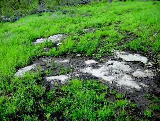
84 View of exposed bedrock, Parcel No. 18. View of exposed bedrock, Parcel No


85 View of abandoned machinery, Parcel No. 16. Parcel No Clifford Road. 44


86 View south at Parcel No. 23. Note illegally dumped trash/debris. Close-up of illegally dumped furniture. Parcel No


87 View south along Lowenstein Road which dead-ends at gate. Geo-tech sub-surface boring location, Parcel No


88 View of un-marked hole to mine below. Typical Parcel No. 19. View east at former mine entrance, Parcel No


89 View of mine entrance and surrounding topography, Parcel No. 19. Entrance unsecured, but on private property. Current mine entrance located north of Clifford Road. Entrance not located within Redevelopment Area. 48


90 View interior of the abandoned mine, typical. Parcel Nos. 15, 16, 19, 20, 21, 22, & 23. View of standing water, typical throughout mine. 49

91 View of a large cave-in location. Former dome-out location where ceiling collapse has occurred. 50


92 Former dome-out locations. Close-up former dome-out location where mine ceiling has collapsed. 51

93 Ceiling collapse location, typical throughout. 52


94 Ceiling collapse location. View of standard column pattern, typical throughout. 53


95 View of abandoned tire dumping location. View north along Old View High Drive. 54


96 View along former Old View High Drive Road. Photo of Old View High Drive and View High Drive intersection, photo looking northwest. Note restricted access. 55


97 Tire pile, Parcel No. 2. Photo of Parcel No. 1, NW Chipman Road. Note lack of curbs, gutter, sidewalks. 56


98 Photo looking north along View High Drive, Parcel Nos. 6 & 7 to the right. Restricted vehicular access to Parcel No. 10. Photo looking north. 57


99 Secured and posted access road, Parcel No. 10. View looking south at Parcel No.10 access road. 58
100 Exhibit C: Property Inspection Forms Property / Facility Inspection Form Tract 1 Date 5/14/13 Inspector JPotter City Lee s Summit, Missouri Project/Survey View High Green TIF Area Address NW Chipman Road Parcel Number Building Type Residential # Stories 1 Building Material n/a Basement: Yes x No Is Property X Yes No Property Size (Sq. Ft.) 232,165 improved Property Condition Retaining Walls Private Sidewalks & Drives Gravel access drive to Chipman to south Lawns & Shrubs Moderately wooded Excessive stored Vehicles (not for retail sales purposes) Open storage Accessory Structures Yes, 2 pole barn structures Public Sidewalks, Curbs, Gutter Catch Basins Street Lights Street Conditions N/A Comments: Single-family residential structure with several outbuildings. Pond located in northern portion of parcel. Access from Chipman Road to south. Condition 1. Inadequate Street Layout 2. Unsanitary / Unsafe Condition 3. Deteriorated Site Improvements 4. Improper Subdivision 5. Obsolete Platting 6. Life Endangering Condition -Fire -Environmental -Other 7. Retardation of Housing Accommodations 8. Economic Liability/Underutilization 9. Social Liability 10. Menace to Pub. Health, Sfty, Mrls, Wlfr Condition Present Comment 59
101 Property / Facility Inspection Form Tract 2 Date 5/14/13 Inspector JPotter City Lee s Summit, Missouri Project/Survey View High Green TIF Area Address Old View High Drive Parcel Number Building Type undeveloped # Stories n/a Building Material n/a Basement: Yes x No Is Property Yes X No Property Size (Sq. Ft.) 1,427,991 improved Property Condition Retaining Walls Private Sidewalks & Drives Former Old View High Drive, poor condition. Lawns & Shrubs Heavily wooded Excessive stored Vehicles (not for retail sales purposes) Open storage Accessory Structures Yes, 2 pole barns located in north central portion of parcel Public Sidewalks, Curbs, Gutter Catch Basins Street Lights Street Conditions N/A Comments: The parcel is heavily wooded on the eastern ½ of parcel. Unmaintained Old View High Drive currently exists on parcel. Access via the south and northwest, but access gates are locked to vehicular traffic. Several piles of trash, debris, tires located in north central portion of site. Condition Condition Comment Present 1. Inadequate Street Layout X Limited at best access to parcel available via View High Drive. Former View High Drive still existing, but severely overgrown and unmaintained. 2. Unsanitary / Unsafe Condition X Unmaintained former View High Drive dangerous to traverse for pedestrian & vehicles. Parcel, heavily overgrown in some locations. Access for emergency vehicles limited in the event of an emergency. 3. Deteriorated Site Improvements 4. Improper Subdivision 5. Obsolete Platting 6. Life Endangering Condition -Fire -Environmental -Other 7. Retardation of Housing Accommodations 8. Economic Liability/Underutilization X This particular parcel is almost entirely undeveloped and heavily wooded and overgrown with vegetation. The parcel s undeveloped nature and underperforming land use has a negative impact on the potential highest and best use of the site. This underperformance also affects the potential reinvestment to the site and surrounding property. 9. Social Liability 10. Menace to Pub. Health, Sfty, Mrls, Wlfr Property is currently vacant and generates minimal revenue to the local taxing jurisdictions annually. It should be anticipated that a higher and better use could be identified to produce increased tax revenue to local jurisdictions. From this perspective, redevelopment of the property is essential. 60
102 Property / Facility Inspection Form Tract 3 Date 5/14/13 Inspector JPotter City Lee s Summit, Missouri Project/Survey View High Green TIF Area Address NW View High Drive Parcel Number Building Type undeveloped # Stories n/a Building Material n/a Basement: Yes x No Is Property Yes X No Property Size (Sq. Ft.) 93,180 improved Property Condition Retaining Walls Private Sidewalks & Drives Lawns & Shrubs Excessive stored Vehicles (not for retail sales purposes) Open storage Accessory Structures Public Sidewalks, Curbs, Gutter Catch Basins Street Lights Street Conditions Comments: The parcel is land-locked. Pond present in central portion of parcel. Heavily wooded on eastern ½ of parcel. Condition Condition Comment Present 1. Inadequate Street Layout X No access to View High Drive. Access via traversing adjacent property. 2. Unsanitary / Unsafe Condition 3. Deteriorated Site Improvements 4. Improper Subdivision 5. Obsolete Platting 6. Life Endangering Condition -Fire -Environmental -Other 7. Retardation of Housing Accommodations 8. Economic Liability/Underutilization X This particular parcel is almost entirely undeveloped and heavily wooded and overgrown with vegetation. The parcel s undeveloped nature and underperforming land use has a negative impact on the potential highest and best use of the site. This underperformance also affects the potential reinvestment to the site and surrounding property. 9. Social Liability 10. Menace to Pub. Health, Sfty, Mrls, Wlfr Property is currently vacant and generates minimal revenue to the local taxing jurisdictions annually. It should be anticipated that a higher and better use could be identified to produce increased tax revenue to local jurisdictions. From this perspective, redevelopment of the property is essential. 61
103 Property / Facility Inspection Form Tract 4 Date 5/14/13 Inspector JPotter City Lee s Summit, Missouri Project/Survey View High Green TIF Area Address No Address Assigned Parcel Number Building Type undeveloped # Stories n/a Building Material n/a Basement: Yes x No Is Property Yes X No Property Size (Sq. Ft.) 98,405 improved Property Condition Retaining Walls Private Sidewalks & Drives Lawns & Shrubs Heavily wooded Excessive stored Vehicles (not for retail sales purposes) Open storage Accessory Structures Public Sidewalks, Curbs, Gutter Catch Basins Street Lights Street Conditions N/A Comments: The parcel is land-locked. Little Blue River present in central portion of parcel. Heavily wooded. Condition Condition Comment Present 1. Inadequate Street Layout X Parcel land-locked, no access. No street/road infrastructure to or within the parcel. 2. Unsanitary / Unsafe Condition X Parcel, heavily overgrown in some locations. Access for emergency vehicles limited in the event of an emergency. 3. Deteriorated Site Improvements 4. Improper Subdivision 5. Obsolete Platting 6. Life Endangering Condition -Fire -Environmental -Other 7. Retardation of Housing Accommodations 8. Economic Liability/Underutilization X This particular parcel is almost entirely undeveloped and heavily wooded and overgrown with vegetation. The parcel s undeveloped nature and underperforming land use has a negative impact on the potential highest and best use of the site. This underperformance also affects the potential reinvestment to the site and surrounding property. 9. Social Liability 10. Menace to Pub. Health, Sfty, Mrls, Wlfr Property is currently vacant and generates minimal revenue to the local taxing jurisdictions annually. It should be anticipated that a higher and better use could be identified to produce increased tax revenue to local jurisdictions. From this perspective, redevelopment of the property is essential. 62
104 Property / Facility Inspection Form Tract 5 Date 5/14/13 Inspector JPotter City Lee s Summit, Missouri Project/Survey View High Green TIF Area Address No Address Assigned Parcel Number Building Type undeveloped # Stories n/a Building Material n/a Basement: Yes x No Is Property Yes X No Property Size (Sq. Ft.) 405,354 improved Property Condition Retaining Walls Private Sidewalks & Drives Lawns & Shrubs Excessive stored Vehicles (not for retail sales purposes) Open storage Accessory Structures Public Sidewalks, Curbs, Gutter Catch Basins Street Lights Street Conditions N/A Comments: The parcel is land-locked. Condition Condition Comment Present 1. Inadequate Street Layout X Parcel land-locked, no access. No street/road infrastructure to or within the parcel. 2. Unsanitary / Unsafe Condition X Parcel, heavily overgrown in some locations. Access for emergency vehicles limited in the event of an emergency. 3. Deteriorated Site Improvements 4. Improper Subdivision 5. Obsolete Platting 6. Life Endangering Condition -Fire -Environmental -Other 7. Retardation of Housing Accommodations 8. Economic Liability/Underutilization X This particular parcel land-locked and entirely undeveloped. The parcel s undeveloped nature and underperforming land use has a negative impact on the potential highest and best use of the site. This underperformance also affects the potential reinvestment to the site and surrounding property. 9. Social Liability 10. Menace to Pub. Health, Sfty, Mrls, Wlfr Property is currently vacant and generates minimal revenue to the local taxing jurisdictions annually. It should be anticipated that a higher and better use could be identified to produce increased tax revenue to local jurisdictions. From this perspective, redevelopment of the property is essential. 63
105 Property / Facility Inspection Form Tract 6 Date 5/14/13 Inspector JPotter City Lee s Summit, Missouri Project/Survey View High Green TIF Area Address NW View High Drive Parcel Number Building Type undeveloped # Stories n/a Building Material n/a Basement: Yes x No Is Property Yes X No Property Size (Sq. Ft.) 73,465 improved Property Condition Retaining Walls Private Sidewalks & Drives Lawns & Shrubs Excessive stored Vehicles (not for retail sales purposes) Open storage Accessory Structures Public Sidewalks, Curbs, Gutter Catch Basins Street Lights Street Conditions N/A Comments: Access via View High Drive. Borders I-470 to south. Condition Condition Comment Present 1. Inadequate Street Layout X Limited access to parcel available via View High Drive to west. No infrastructure existing. 2. Unsanitary / Unsafe Condition 3. Deteriorated Site Improvements 4. Improper Subdivision 5. Obsolete Platting 6. Life Endangering Condition -Fire -Environmental -Other 7. Retardation of Housing Accommodations 8. Economic Liability/Underutilization X This particular parcel is undeveloped. The parcel s undeveloped nature and underperforming land use has a negative impact on the potential highest and best use of the site. This underperformance also affects the potential reinvestment to the site and surrounding property. 9. Social Liability 10. Menace to Pub. Health, Sfty, Mrls, Wlfr Property is currently vacant and generates minimal revenue to the local taxing jurisdictions annually. It should be anticipated that a higher and better use could be identified to produce increased tax revenue to local jurisdictions. From this perspective, redevelopment of the property is essential. 64
106 Property / Facility Inspection Form Tract 7 Date 5/14/13 Inspector JPotter City Lee s Summit, Missouri Project/Survey View High Green TIF Area Address No Address Assigned Parcel Number Building Type undeveloped # Stories n/a Building Material n/a Basement: Yes x No Is Property Yes X No Property Size (Sq. Ft.) 81,258 improved Property Condition Retaining Walls Private Sidewalks & Drives Lawns & Shrubs Excessive stored Vehicles (not for retail sales purposes) Open storage Accessory Structures Public Sidewalks, Curbs, Gutter Catch Basins Street Lights Street Conditions N/A Comments: Access via View High Drive. Condition Condition Comment Present 1. Inadequate Street Layout X Limited access to parcel available via View High Drive to west. No infrastructure existing. 2. Unsanitary / Unsafe Condition 3. Deteriorated Site Improvements 4. Improper Subdivision 5. Obsolete Platting 6. Life Endangering Condition -Fire -Environmental -Other 7. Retardation of Housing Accommodations 8. Economic Liability/Underutilization X This particular parcel is undeveloped. The parcel s undeveloped nature and underperforming land use has a negative impact on the potential highest and best use of the site. This underperformance also affects the potential reinvestment to the site and surrounding property. 9. Social Liability 10. Menace to Pub. Health, Sfty, Mrls, Wlfr Property is currently vacant and generates minimal revenue to the local taxing jurisdictions annually. It should be anticipated that a higher and better use could be identified to produce increased tax revenue to local jurisdictions. From this perspective, redevelopment of the property is essential. 65
107 Property / Facility Inspection Form Tract 8 Date 5/14/13 Inspector JPotter City Lee s Summit, Missouri Project/Survey View High Green TIF Area Address No Address Assigned Parcel Number Building Type undeveloped # Stories n/a Building Material n/a Basement: Yes x No Is Property Yes X No Property Size (Sq. Ft.) 108,639 improved Property Condition Retaining Walls Private Sidewalks & Drives Lawns & Shrubs Excessive stored Vehicles (not for retail sales purposes) Open storage Accessory Structures Public Sidewalks, Curbs, Gutter Catch Basins Street Lights Street Conditions N/A Comments: The parcel is land-locked. Condition Condition Comment Present 1. Inadequate Street Layout X Parcel land-locked, no access. No street/road infrastructure to or within the parcel. 2. Unsanitary / Unsafe Condition X Parcel, heavily overgrown in some locations. Access for emergency vehicles limited in the event of an emergency. 3. Deteriorated Site Improvements 4. Improper Subdivision 5. Obsolete Platting 6. Life Endangering Condition -Fire -Environmental -Other 7. Retardation of Housing Accommodations 8. Economic Liability/Underutilization X This particular parcel is undeveloped. The parcel s undeveloped nature and underperforming land use has a negative impact on the potential highest and best use of the site. This underperformance also affects the potential reinvestment to the site and surrounding property. 9. Social Liability 10. Menace to Pub. Health, Sfty, Mrls, Wlfr Property is currently vacant and generates minimal revenue to the local taxing jurisdictions annually. It should be anticipated that a higher and better use could be identified to produce increased tax revenue to local jurisdictions. From this perspective, redevelopment of the property is essential. 66
108 Property / Facility Inspection Form Tract 9 Date 5/14/13 Inspector JPotter City Lee s Summit, Missouri Project/Survey View High Green TIF Area Address No Address Assigned Parcel Number Building Type undeveloped # Stories n/a Building Material n/a Basement: Yes x No Is Property Yes X No Property Size (Sq. Ft.) 66,376 improved Property Condition Retaining Walls Private Sidewalks & Drives Lawns & Shrubs Heavily wooded Excessive stored Vehicles (not for retail sales purposes) Open storage Accessory Structures Public Sidewalks, Curbs, Gutter Catch Basins Street Lights Street Conditions N/A Comments: The parcel is heavily wooded, Little Blue River flows through central portion of parcel. Condition Condition Comment Present 1. Inadequate Street Layout X Limited access to parcel available via View High Drive to west. No infrastructure existing. 2. Unsanitary / Unsafe Condition 3. Deteriorated Site Improvements 4. Improper Subdivision 5. Obsolete Platting 6. Life Endangering Condition -Fire -Environmental -Other 7. Retardation of Housing Accommodations 8. Economic Liability/Underutilization X This particular parcel is almost entirely undeveloped and heavily wooded and overgrown with vegetation. The parcel s undeveloped nature and underperforming land use has a negative impact on the potential highest and best use of the site. This underperformance also affects the potential reinvestment to the site and surrounding property. 9. Social Liability 10. Menace to Pub. Health, Sfty, Mrls, Wlfr Property is currently vacant and generates minimal revenue to the local taxing jurisdictions annually. It should be anticipated that a higher and better use could be identified to produce increased tax revenue to local jurisdictions. From this perspective, redevelopment of the property is essential. 67
109 Property / Facility Inspection Form Tract 10 Date 5/14/13 Inspector JPotter City Lee s Summit, Missouri Project/Survey View High Green TIF Area Address No Address Assigned Parcel Number Building Type undeveloped # Stories n/a Building Material n/a Basement: Yes x No Is Property Yes X No Property Size (Sq. Ft.) 3,412,490 improved Property Condition Retaining Walls Private Sidewalks & Drives Lawns & Shrubs Portions of parcel heavily wooded Excessive stored Vehicles (not for retail sales purposes) Open storage Accessory Structures Public Sidewalks, Curbs, Gutter Catch Basins Street Lights Street Conditions N/A Comments: Portions of parcel heavily wooded. Little Blue River flows through parcel. Access in southwest corner of parcel at View High Drive. Vehicular and pedestrian access no possible. Condition Condition Comment Present 1. Inadequate Street Layout X Parcel land-locked, no access. No street/road infrastructure to or within the parcel. 2. Unsanitary / Unsafe Condition X Parcel, heavily overgrown in some locations. Access for emergency vehicles limited in the event of an emergency. 3. Deteriorated Site Improvements 4. Improper Subdivision 5. Obsolete Platting 6. Life Endangering Condition -Fire -Environmental -Other 7. Retardation of Housing Accommodations 8. Economic Liability/Underutilization X This particular parcel is almost entirely undeveloped and heavily wooded and overgrown with vegetation. The parcel s undeveloped nature and underperforming land use has a negative impact on the potential highest and best use of the site. This underperformance also affects the potential reinvestment to the site and surrounding property. 9. Social Liability 10. Menace to Pub. Health, Sfty, Mrls, Wlfr Property is currently vacant and generates minimal revenue to the local taxing jurisdictions annually. It should be anticipated that a higher and better use could be identified to produce increased tax revenue to local jurisdictions. From this perspective, redevelopment of the property is essential. 68
110 Property / Facility Inspection Form Tract 11 Date 5/14/13 Inspector JPotter City Lee s Summit, Missouri Project/Survey View High Green TIF Area Address No Address Assigned Parcel Number Building Type undeveloped # Stories n/a Building Material n/a Basement: Yes x No Is Property Yes X No Property Size (Sq. Ft.) 1,013,007 improved Property Condition Retaining Walls Private Sidewalks & Drives Lawns & Shrubs Heavily wooded Excessive stored Vehicles (not for retail sales purposes) Open storage Accessory Structures Public Sidewalks, Curbs, Gutter Catch Basins Street Lights Street Conditions N/A Comments: Parcel landlocked, heavily wooded. Little Blue River flows through parcel. Condition Condition Comment Present 1. Inadequate Street Layout X Parcel land-locked, no access. No street/road infrastructure to or within the parcel. 2. Unsanitary / Unsafe Condition X Parcel, heavily overgrown in some locations. Access for emergency vehicles limited in the event of an emergency. 3. Deteriorated Site Improvements 4. Improper Subdivision 5. Obsolete Platting 6. Life Endangering Condition -Fire -Environmental -Other 7. Retardation of Housing Accommodations 8. Economic Liability/Underutilization X This particular parcel is almost entirely undeveloped and heavily wooded and overgrown with vegetation. The parcel s undeveloped nature and underperforming land use has a negative impact on the potential highest and best use of the site. This underperformance also affects the potential reinvestment to the site and surrounding property. 9. Social Liability 10. Menace to Pub. Health, Sfty, Mrls, Wlfr Property is currently vacant and generates minimal revenue to the local taxing jurisdictions annually. It should be anticipated that a higher and better use could be identified to produce increased tax revenue to local jurisdictions. From this perspective, redevelopment of the property is essential. 69
111 Property / Facility Inspection Form Tract 12 Date 5/14/13 Inspector JPotter City Lee s Summit, Missouri Project/Survey View High Green TIF Area Address No Address Assigned Parcel Number Building Type undeveloped # Stories n/a Building Material n/a Basement: Yes x No Is Property Yes X No Property Size (Sq. Ft.) 81,182 improved Property Condition Retaining Walls Private Sidewalks & Drives Lawns & Shrubs Heavily wooded Excessive stored Vehicles (not for retail sales purposes) Open storage Accessory Structures Public Sidewalks, Curbs, Gutter Catch Basins Street Lights Street Conditions N/A Comments: The parcel is heavily wooded & land locked. Adjacent to abandoned rail line. Condition Condition Comment Present 1. Inadequate Street Layout X Parcel land-locked, no access. No street/road infrastructure to or within the parcel. 2. Unsanitary / Unsafe Condition X Parcel, heavily overgrown in some locations. Access for emergency vehicles limited in the event of an emergency. 3. Deteriorated Site Improvements 4. Improper Subdivision 5. Obsolete Platting 6. Life Endangering Condition -Fire -Environmental -Other 7. Retardation of Housing Accommodations 8. Economic Liability/Underutilization X This particular parcel land-locked and entirely undeveloped. The parcel s undeveloped nature and underperforming land use has a negative impact on the potential highest and best use of the site. This underperformance also affects the potential reinvestment to the site and surrounding property. 9. Social Liability 10. Menace to Pub. Health, Sfty, Mrls, Wlfr Property is currently vacant and generates minimal revenue to the local taxing jurisdictions annually. It should be anticipated that a higher and better use could be identified to produce increased tax revenue to local jurisdictions. From this perspective, redevelopment of the property is essential. 70
112 Property / Facility Inspection Form Tract 13 Date 5/14/13 Inspector JPotter City Lee s Summit, Missouri Project/Survey View High Green TIF Area Address No Address Assigned Parcel Number Building Type undeveloped # Stories n/a Building Material n/a Basement: Yes x No Is Property Yes X No Property Size (Sq. Ft.) 405,097 improved Property Condition Retaining Walls Private Sidewalks & Drives Lawns & Shrubs Heavily wooded Excessive stored Vehicles (not for retail sales purposes) Open storage Accessory Structures Public Sidewalks, Curbs, Gutter Catch Basins Street Lights Street Conditions N/A Comments: The parcel is heavily wooded and land locked. No vehicular or pedestrian access. Condition Condition Comment Present 1. Inadequate Street Layout X Parcel land-locked, no access. No street/road infrastructure to or within the parcel. 2. Unsanitary / Unsafe Condition X Parcel, heavily overgrown in some locations. Access for emergency vehicles limited in the event of an emergency. 3. Deteriorated Site Improvements 4. Improper Subdivision 5. Obsolete Platting 6. Life Endangering Condition -Fire -Environmental -Other 7. Retardation of Housing Accommodations 8. Economic Liability/Underutilization X This particular parcel is almost entirely undeveloped and heavily wooded and overgrown with vegetation. The parcel s undeveloped nature and underperforming land use has a negative impact on the potential highest and best use of the site. This underperformance also affects the potential reinvestment to the site and surrounding property. 9. Social Liability 10. Menace to Pub. Health, Sfty, Mrls, Wlfr Property is currently vacant and generates minimal revenue to the local taxing jurisdictions annually. It should be anticipated that a higher and better use could be identified to produce increased tax revenue to local jurisdictions. From this perspective, redevelopment of the property is essential. 71
113 Property / Facility Inspection Form Tract 14 Date 5/14/13 Inspector JPotter City Lee s Summit, Missouri Project/Survey View High Green TIF Area Address No Address Assigned Parcel Number Building Type undeveloped # Stories n/a Building Material n/a Basement: Yes x No Is Property Yes X No Property Size (Sq. Ft.) 1,315,102 improved Property Condition Retaining Walls Private Sidewalks & Drives Lawns & Shrubs Heavily wooded Excessive stored Vehicles (not for retail sales purposes) Open storage Accessory Structures Public Sidewalks, Curbs, Gutter Catch Basins Street Lights Street Conditions N/A Comments: The parcel is heavily wooded and land locked. Little Blue River flowing through parcel. Condition Condition Comment Present 1. Inadequate Street Layout X Parcel land-locked, no access. No street/road infrastructure to or within the parcel. 2. Unsanitary / Unsafe Condition X Parcel, heavily overgrown in some locations. Access for emergency vehicles limited in the event of an emergency. 3. Deteriorated Site Improvements 4. Improper Subdivision 5. Obsolete Platting 6. Life Endangering Condition -Fire -Environmental -Other 7. Retardation of Housing Accommodations 8. Economic Liability/Underutilization X This particular parcel is almost entirely undeveloped and heavily wooded and overgrown with vegetation. The parcel s undeveloped nature and underperforming land use has a negative impact on the potential highest and best use of the site. This underperformance also affects the potential reinvestment to the site and surrounding property. 9. Social Liability 10. Menace to Pub. Health, Sfty, Mrls, Wlfr Property is currently vacant and generates minimal revenue to the local taxing jurisdictions annually. It should be anticipated that a higher and better use could be identified to produce increased tax revenue to local jurisdictions. From this perspective, redevelopment of the property is essential. 72
114 Property / Facility Inspection Form Tract 15 Date 5/14/13 Inspector JPotter City Lee s Summit, Missouri Project/Survey View High Green TIF Area Address 2750 NW Clifford Road Parcel Number Building Type Residential # Stories 1 Building Material n/a Basement: Yes x No Is Property X Yes No Property Size (Sq. Ft.) 515,598 improved Property Condition Retaining Walls Private Sidewalks & Drives Fair Lawns & Shrubs Fair Excessive stored Vehicles (not for retail sales purposes) Open storage Accessory Structures Public Sidewalks, Curbs, Gutter Catch Basins Street Lights Street Conditions N/A Comments: Single-family detached residential. Access via Clifford Road. Portions of this parcel are above the abandoned underground mine. Condition Condition Comment Present 1. Inadequate Street Layout X Parcel land-locked, no access. No street/road infrastructure to or within the parcel. 2. Unsanitary / Unsafe Condition X Parcel, heavily overgrown in some locations. Access for emergency vehicles limited in the event of an emergency. 3. Deteriorated Site Improvements X Portions of parcel reside over former underground vacant mine. Mining conditions are severely deteriorated and structure is failing in numerous locations. Structural columns are not designed to modern standards and mine roof system in deteriorating and failing in scattered locations. 4. Improper Subdivision 5. Obsolete Platting 6. Life Endangering Condition -Fire -Environmental -Other 7. Retardation of Housing Accommodations 8. Economic Liability/Underutilization X This particular is entirely undeveloped. The parcel s undeveloped nature and underperforming land use has a negative impact on the potential highest and best use of the site. This underperformance also affects the potential reinvestment to the site and surrounding property. Property is currently vacant and generates minimal revenue to the local taxing jurisdictions annually. It should be anticipated that a higher and better use could be identified to produce increased tax revenue to local jurisdictions. From this perspective, redevelopment of the property is essential. 9. Social Liability 10. Menace to Pub. Health, Sfty, Mrls, Wlfr Additionally, anticipated significant mine remediation costs will be associated with the redevelopment/development of this parcel. 73
115 Property / Facility Inspection Form Tract 16 Date 5/14/13 Inspector JPotter City Lee s Summit, Missouri Project/Survey View High Green TIF Area Address No Address Assigned Parcel Number Building Type undeveloped # Stories n/a Building Material n/a Basement: Yes x No Is Property Yes X No Property Size (Sq. Ft.) 839,993 improved Property Condition Retaining Walls Private Sidewalks & Drives Lawns & Shrubs Heavily wooded along southern 2/3rds of parcel Excessive stored Vehicles (not for retail sales purposes) Open storage Accessory Structures Public Sidewalks, Curbs, Gutter Catch Basins Street Lights Street Conditions N/A Comments: The parcel is heavily wooded on the southern 2/3 of parcel. Access view Clifford Road to north. The majority of this parcel resided directly above abandoned underground mine. Condition Condition Present Comment 1. Inadequate Street Layout 2. Unsanitary / Unsafe Condition X Mine access is unsecured and lacks any utilities. It presents an extremely unsafe environment if accessed without the appropriate safety gear. 3. Deteriorated Site Improvements X Portions of parcel reside over former underground vacant mine. Mining conditions are severely deteriorated and structure is failing in numerous locations. Structural columns are not designed to modern standards and mine roof system in deteriorating and failing in scattered locations. 4. Improper Subdivision 5. Obsolete Platting 6. Life Endangering Condition -Fire -Environmental -Other 7. Retardation of Housing Accommodations 8. Economic Liability/Underutilization X This particular parcel is almost entirely undeveloped and heavily wooded and overgrown with vegetation. The parcel s undeveloped nature and underperforming land use has a negative impact on the potential highest and best use of the site. This underperformance also affects the potential reinvestment to the site and surrounding property. Property is currently vacant and generates minimal revenue to the local taxing jurisdictions annually. It should be anticipated that a higher and better use could be identified to produce increased tax revenue to local jurisdictions. From this perspective, redevelopment of the property is essential. 9. Social Liability 10. Menace to Pub. Health, Sfty, Mrls, Wlfr Additionally, anticipated significant mine remediation costs will be associated with the redevelopment/development of this parcel. 74
116 Property / Facility Inspection Form Tract 17 Date 5/14/13 Inspector JPotter City Lee s Summit, Missouri Project/Survey View High Green TIF Area Address No Address Assigned Parcel Number Building Type undeveloped # Stories n/a Building Material n/a Basement: Yes x No Is Property Yes X No Property Size (Sq. Ft.) 127,839 improved Property Condition Retaining Walls Private Sidewalks & Drives Lawns & Shrubs Heavily wooded Excessive stored Vehicles (not for retail sales purposes) Open storage Accessory Structures Public Sidewalks, Curbs, Gutter Catch Basins Street Lights Street Conditions N/A Comments: Parcel land locked, no vehicular or pedestrian access. Adjacent to I470 to south. Condition Condition Comment Present 1. Inadequate Street Layout X Parcel landlocked. Access to parcel available via traversing adjacent property. 2. Unsanitary / Unsafe Condition 3. Deteriorated Site Improvements 4. Improper Subdivision 5. Obsolete Platting 6. Life Endangering Condition -Fire -Environmental -Other 7. Retardation of Housing Accommodations 8. Economic Liability/Underutilization X This particular parcel is almost entirely undeveloped and heavily wooded and overgrown with vegetation. The parcel s undeveloped nature and underperforming land use has a negative impact on the potential highest and best use of the site. This underperformance also affects the potential reinvestment to the site and surrounding property. 9. Social Liability 10. Menace to Pub. Health, Sfty, Mrls, Wlfr Property is currently vacant and generates minimal revenue to the local taxing jurisdictions annually. It should be anticipated that a higher and better use could be identified to produce increased tax revenue to local jurisdictions. From this perspective, redevelopment of the property is essential. 75
117 Property / Facility Inspection Form Tract 18 Date 5/14/13 Inspector JPotter City Lee s Summit, Missouri Project/Survey View High Green TIF Area Address No Address Assigned Parcel Number Building Type undeveloped # Stories n/a Building Material n/a Basement: Yes x No Is Property Yes X No Property Size (Sq. Ft.) 155,968 improved Property Condition Retaining Walls Private Sidewalks & Drives Lawns & Shrubs Heavily wooded Excessive stored Vehicles (not for retail sales purposes) Open storage Accessory Structures Public Sidewalks, Curbs, Gutter Catch Basins Street Lights Street Conditions N/A Comments: The parcel is heavily wooded and land locked. Adjacent to I470 to the south. Condition Condition Comment Present 1. Inadequate Street Layout X Parcel landlocked. Access to parcel available via traversing adjacent property. 2. Unsanitary / Unsafe Condition 3. Deteriorated Site Improvements 4. Improper Subdivision 5. Obsolete Platting 6. Life Endangering Condition -Fire -Environmental -Other 7. Retardation of Housing Accommodations 8. Economic Liability/Underutilization X This particular parcel is almost entirely undeveloped and heavily wooded and overgrown with vegetation. The parcel s undeveloped nature and underperforming land use has a negative impact on the potential highest and best use of the site. This underperformance also affects the potential reinvestment to the site and surrounding property. 9. Social Liability 10. Menace to Pub. Health, Sfty, Mrls, Wlfr Property is currently vacant and generates minimal revenue to the local taxing jurisdictions annually. It should be anticipated that a higher and better use could be identified to produce increased tax revenue to local jurisdictions. From this perspective, redevelopment of the property is essential. 76
118 Property / Facility Inspection Form Tract 19 Date 5/14/13 Inspector JPotter City Lee s Summit, Missouri Project/Survey View High Green TIF Area Address No Address Assigned Parcel Number Building Type undeveloped # Stories n/a Building Material n/a Basement: Yes x No Is Property Yes X No Property Size (Sq. Ft.) 1,180,113 improved Property Condition Retaining Walls Private Sidewalks & Drives Gravel drive accessible from Clifford Road to north Lawns & Shrubs N/A Excessive stored Vehicles (not for retail sales purposes) Open storage Accessory Structures Yes, large barn located on parcel Public Sidewalks, Curbs, Gutter Catch Basins Street Lights Street Conditions N/A Comments: Parcel accessible from Clifford Rd to north. Large Barn located southwest corner of parcel. Majority of parcel is located above abandoned, underground mine. Mine access location present in south central portion of parcel. Condition Condition Present Comment 1. Inadequate Street Layout 2. Unsanitary / Unsafe Condition X Mine access is unsecured and lacks any utilities. It presents an extremely unsafe environment if accessed without the appropriate safety gear. 3. Deteriorated Site Improvements X Portions of parcel reside over former underground vacant mine. Mining conditions are severely deteriorated and structure is failing in numerous locations. Structural columns are not designed to modern standards and mine roof system in deteriorating and failing in scattered locations. 4. Improper Subdivision 5. Obsolete Platting 6. Life Endangering Condition -Fire -Environmental -Other 7. Retardation of Housing Accommodations 8. Economic Liability/Underutilization X The majority of this particular parcel is undeveloped. The parcel s undeveloped nature and underperforming land use has a negative impact on the potential highest and best use of the site. This underperformance also affects the potential reinvestment to the site and surrounding property. Property is currently vacant and generates minimal revenue to the local taxing jurisdictions annually. It should be anticipated that a higher and better use could be identified to produce increased tax revenue to local jurisdictions. From this perspective, redevelopment of the property is essential. 9. Social Liability 10. Menace to Pub. Health, Sfty, Mrls, Wlfr Additionally, anticipated significant mine remediation costs will be associated with the redevelopment/development of this parcel. 77
119 Property / Facility Inspection Form Tract 20 Date 5/14/13 Inspector JPotter City Lee s Summit, Missouri Project/Survey View High Green TIF Area Address 2251 NW Clifford Rd. Parcel Number Building Type undeveloped # Stories n/a Building Material n/a Basement: Yes x No Is Property Yes X No Property Size (Sq. Ft.) 1,602,813 improved Property Condition Retaining Walls Private Sidewalks & Drives Lawns & Shrubs Excessive stored Vehicles (not for retail sales purposes) Open storage Accessory Structures Public Sidewalks, Curbs, Gutter Catch Basins Street Lights Street Conditions N/A Comments: Parcel accessible view Lowenstein Dr.. on the eastern border of parcel. The majority of parcel is located above abandoned, under-ground mine. A large amount of trash and debris has been illegally dumped in eastern portion of parcel. Condition Condition Present Comment 1. Inadequate Street Layout 2. Unsanitary / Unsafe Condition X Mine access is unsecured and lacks any utilities. It presents an extremely unsafe environment if accessed without the appropriate safety gear. 3. Deteriorated Site Improvements X Portions of parcel reside over former underground vacant mine. Mining conditions are severely deteriorated and structure is failing in numerous locations. Structural columns are not designed to modern standards and mine roof system in deteriorating and failing in scattered locations. 4. Improper Subdivision 5. Obsolete Platting 6. Life Endangering Condition -Fire -Environmental -Other 7. Retardation of Housing Accommodations 8. Economic Liability/Underutilization X This particular parcel is entirely undeveloped. The parcel s undeveloped nature and underperforming land use has a negative impact on the potential highest and best use of the site. This underperformance also affects the potential reinvestment to the site and surrounding property. Property is currently vacant and generates minimal revenue to the local taxing jurisdictions annually. It should be anticipated that a higher and better use could be identified to produce increased tax revenue to local jurisdictions. From this perspective, redevelopment of the property is essential. 9. Social Liability 10. Menace to Pub. Health, Sfty, Mrls, Wlfr Additionally, anticipated significant mine remediation costs will be associated with the redevelopment/development of this parcel. 78
120 Property / Facility Inspection Form Tract 21 Date 5/14/13 Inspector JPotter City Lee s Summit, Missouri Project/Survey View High Green TIF Area Address No Address Assigned Parcel Number Building Type undeveloped # Stories n/a Building Material n/a Basement: Yes x No Is Property Yes X No Property Size (Sq. Ft.) 235,381 improved Property Condition Retaining Walls Private Sidewalks & Drives Lawns & Shrubs Heavily wooded Excessive stored Vehicles (not for retail sales purposes) Open storage Accessory Structures Public Sidewalks, Curbs, Gutter Catch Basins Street Lights Street Conditions N/A Comments: Heavily wooded parcel. Condition Condition Present Comment 1. Inadequate Street Layout 2. Unsanitary / Unsafe Condition X Mine access is unsecured and lacks any utilities. It presents an extremely unsafe environment if accessed without the appropriate safety gear. 3. Deteriorated Site Improvements X Portions of parcel reside over former underground vacant mine. Mining conditions are severely deteriorated and structure is failing in numerous locations. Structural columns are not designed to modern standards and mine roof system in deteriorating and failing in scattered locations. 4. Improper Subdivision 5. Obsolete Platting 6. Life Endangering Condition -Fire -Environmental -Other 7. Retardation of Housing Accommodations 8. Economic Liability/Underutilization X This particular parcel is entirely undeveloped. The parcel s undeveloped nature and underperforming land use has a negative impact on the potential highest and best use of the site. This underperformance also affects the potential reinvestment to the site and surrounding property. Property is currently vacant and generates minimal revenue to the local taxing jurisdictions annually. It should be anticipated that a higher and better use could be identified to produce increased tax revenue to local jurisdictions. From this perspective, redevelopment of the property is essential. 9. Social Liability 10. Menace to Pub. Health, Sfty, Mrls, Wlfr Additionally, anticipated significant mine remediation costs will be associated with the redevelopment/development of this parcel. 79
121 Exhibit D: Certification I certify that, to the best of my knowledge and belief 1. The statements of fact contained in this report are true and correct. 2. The reported analyses, opinions, and conclusions are limited only by the reported assumptions and limiting conditions, and are my personal, unbiased professional analyses, opinions, and conclusions. 3. I have no present or prospective interest in the property that is the subject of this report, and I have no personal interest with respect to the parties involved. 4. I have no bias with respect to the property that is the subject of this report or to the parties involved with this assignment. 5. My compensation is not contingent on an action or event resulting from the analyses, opinions, or conclusions in, or the use of, this report. 6. Jim Potter, AICP has made a personal inspection of the property that is the subject of this report on May 9 & 14, This study is not based on a requested result or a specific conclusion. 8. I have not relied on unsupported conclusions relating to characteristics such as race, color, religion, national origin, gender, marital status, familial status, age, receipt of public assistance income, handicap, or an unsupported conclusion that homogeneity of such characteristics is necessary to maximize value. James Potter, AICP, LEED GA Development Initiatives 80
122 Exhibit E: Assumptions and Limiting Conditions This Blight Study is subject to the following limited conditions and assumptions: 1. The reported analyses, opinions, and conclusions are limited only by the reported assumptions and limiting conditions, and are Development Initiatives, unbiased professional analyses, opinions, and conclusions. 2. Information provided and utilized by various secondary sources is assumed to be accurate. Development Initiatives cannot guarantee information obtained from secondary sources. 3. The nature of real estate development is an unpredictable and often tumultuous. In particular, the natural course of development is difficult to predict and forecast. Development Initiatives deems our projections as reasonable considering the current and obtained information. 4. Development Initiatives has considered and analyzed the existing conditions concerning the subject property within the Redevelopment Area. We have considered these existing conditions while making our analysis and conclusions. However, it should be understood that conditions are subject to change without warning, and potential changes could substantially effect our recommendations. 5. Our analyses, opinions and conclusions were prepared in conformance with the Code of Professional Ethics and Standards of the American Institute of Certified Planners. 81
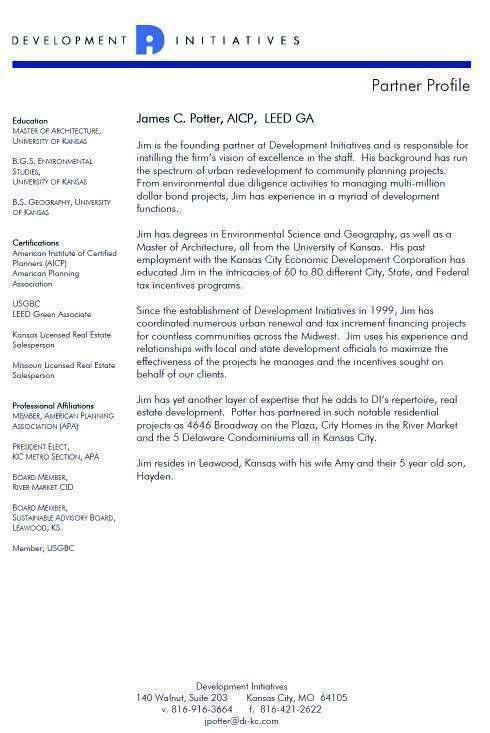
123 82
124 DEVELOPMENT INITIATIVES, BLIGHT/CONSERVATION-HISTORICAL PROJECT SUMMARY BLIGHT ANALYSIS (353), HEER S BUILDING, SPRINGFIELD, MO BLIGHT ANALYSIS (353), BELVOIR 353 PLAN, LIBERTY, MO BLIGHT ANALYSIS (TIF), BELVOIR TIF PLAN, LIBERTY, MO BLIGHT ANALYSIS (CID), SOUTH 63 CORRIDOR CID, CITY OF KIRKSVILLE, MO CONSERVATION ANALYSIS (TIF), WINCHESTER, KANSAS CITY, MO BLIGHT ANALYSIS (TIF), CARONDELET, KANSAS CITY, MO BLIGHT ANALYSIS (TIF), SUNRISE BEACH, MISSOURI BLIGHT ANALYSIS (353), CITY OF LEE S SUMMIT, MISSOURI BLIGHT ANALYSIS (LCRA), DOWTOWN CORE, CITY OF LEE S SUMMIT, MO BLIGHT ANALYSIS (LCRA), LICATA PLAN, CITY OF LEE S SUMMIT, MO BLIGHT ANALYSIS (353), CITY OF LIBERTY, MISSOURI BLIGHT ANALYSIS-PEER REVIEW (353), GRANDVIEW, MO BLIGHT ANALYSIS (CID), CROSSROADS SHOPPING CENTER, LIBERTY, MO BLIGHT ANALYSIS (TIF), HIGHWAY Y & 58, BELTON, MO BLIGHT ANALYSIS(CID), LIBERTY CORNERS SHOPPING CENTER, LIBERTY, MO BLIGHT ANALYSIS AND REDEVELOPMENT PLAN (PIEA), VIVION CORRIDOR, KMCO BLIGHT ANALYSIS (TIF), SOUTH HIGHWAY 63 CORRIDOR, KIRKSVILLE, MISSOURI BLIGHT ANALYSIS-PEER REVIEW, (TIF), ATCHISON, MISSOURI BLIGHT ANALYSIS (TIF), HIGHPOINTE SHOPPING CENTER, OSAGE BEACH, MISSOURI BLIGHT ANALYSIS AND REDEVELOPMENT PLAN (PIEA), 39 TH & STATE LINE, KCMO CONSERVATION ANALYSIS (MODESA), LAKE OZARK, MISSOURI BLIGHT ANALYSIS-PEER REVIEW, (TIF), MARINA VIEW, KIRKSVILLE, MISSOURI CONSERVATION ANALYSIS (TIF), CLAYTON, MISSOURI BLIGHT ANALYSIS, (TIF), DOGWOOD CENTRE, KIRKSVILLE, MISSOURI BLIGHT ANALYSIS, (TIF), BRISCOE TIF, LAKE OZARK, MISSOURI BLIGHT ANALYSIS, (TIF), US 54 & BUSINESS 54, LAKE OZARK, MISSOURI BLIGHT ANALYSIS, (TIF), QUADRA TIF, BELTON, MISSOURI BLIGHT ANALYSIS AND REDEVELOPMENT PLAN (PIEA), DODSON PIEA, KCMO BLIGHT ANALYSIS AND REDEVELOPMENT PLAN (PIEA), CROSSROADS ARTS, KCMO BLIGHT ANALYSIS AND REDEVELOPMENT PLAN (PIEA), CROSSROADS AMENDMENT, KCMO BLIGHT ANALYSIS, (TIF), ROGERS SPORTING GOODS, LIBERTY, MISSOURI BLIGHT ANALYSIS, (TIF), BELTON MARKETPLACE, BELTON, MISSOURI BLIGHT ANALYSIS-PEER REVIEW, (353), WESTFIELD CORPORATION, ST. CHARLES, MISSOURI BLIGHT ANALYSIS, (TIF), KANSAS CITY, MO SWOPE COMMUNITY BUILDERS CONSERVATION ANALYSIS, (TIF), LAKE LOTAWANA, MO BLIGHT ANALYSIS, (TIF), OSAGE BEACH, MO, OAK RIDGE LANDING DEVELOPMENT BLIGHT ANALYSIS, (TIF), LAKE OZARK, MO, STANTON DEVELOPMENT COMPANY BLIGHT ANALYSIS AND REDEVELOPMENT PLAN (PIEA), WASHINGTON 23 AMENDMENT, KCMO BLIGHT ANALYSIS AND REDEVELOPMENT PLAN (PIEA), FILM ROW, KCMO CONSERVATION ANALYSIS, (TIF), KANSAS CITY, MO, TIME EQUITIES, INC., NEW YORK, NY BLIGHT ANALYSIS AND REDEVELOPMENT PLAN (PIEA), VALENTINE/BROADWAY, KCMO BLIGHT ANALYSIS AND REDEVELOPMENT PLAN (PIEA), WASHINGTON 23, KCMO BLIGHT ANALYSIS AND REDEVELOPMENT PLAN (PIEA), BOULEVARD BREWING COMPANY, KCMO BLIGHT ANALYSIS (TIF), OZARK DIVERSIFIED DEVELOPERS, BRANSON, MO BLIGHT ANALYSIS (TIF), MCCOWN GORDON CONSTRUCTION, KCMO BLIGHT ANALYSIS AND REDEVELOPMENT PLAN (PIEA), LEVITT ENTERPRISES, KCMO BLIGHT ANALYSIS AND REDEVELOPMENT PLAN (PIEA), TIME EQUITIES, NY, NY BLIGHT ANALYSIS AND REDEVELOPMENT PLAN (PIEA), URBAN COEUR DEVELOPMENT, KCMO BLIGHT ANALYSIS (TIF), HOSPITALITY MANAGEMENT ASSOC., LINCOLN, NE 83
125 BLIGHT ANALYSIS (TIF), HUSCH & EPPENBERGER, LLC, KANSAS CITY, MO BLIGHT ANALYSIS AND REDEVELOPMENT PLAN (PIEA), KANSAS CITY NEIGHBORHOOD ALLIANCE, KANSAS CITY, MO BLIGHT ANALYSIS (TIF), KING HERSHEY, ATTORNEYS AT LAW, KCMO BLIGHT ANALYSIS (TIF), LATHROP & GAGE, ATTORNEYS AT LAW, KCMO BLIGHT ANALYSIS (TIF), POLSINELLI SHALTON WELTE, ATTORNEYS AT LAW, KANSAS CITY, MO BLIGHT ANALYSIS AND REDEVELOPMENT PLAN (PIEA), COMPASS ENVIRONMENTAL, CHICAGO, ILLINOIS BLIGHT ANALYSIS (TIF), DST REALTY, KANSAS CITY, MO BLIGHT ANALYSIS AND REDEVELOPMENT PLAN (PIEA) MCZ CENTRUM, CHICAGO, ILLINOIS BLIGHT ANALYSIS AND REDEVELOPMENT PLAN (PIEA) UNION HILL DEVELOPMENT, KCMO BLIGHT STUDY AND ANALYSIS (TIF), GRAIN VALLEY, MISSOURI, WARD DEVELOPMENT COMPANY BLIGHT STUDY AND ANALYSIS, PERSHING STATION PARTNERS, KANSAS CITY, MISSOURI 84
126
127
128
129
130
131
132
133
134
135
136
137
138
139
140
141
142
143
144
145
146
147
148
149
150
151 15 Exhibit 9: Land Acquisition Map
152
153
154
155 Exhibit 12 - Summary of Evidence of Financial Commitment 02/17/2016 Private Project Cost to Build and Sports Complex Revised TIF Plan - Exhibit 7 Components Evidence of Financial Commitment Hotel 18,078,000 18,078,000 Capital Management, Inc. Retail (non-restaurant/bar) 4,900,000 4,900,000 First National Bank of Kansas Garage (300 stalls) 4,500,000 4,500,000 Van Trust Real Estate Retail (restaurant/bar) 6,000,000 6,000,000 First National Bank of Kansas Entertainment center 23,580,000 23,580,000 First National Bank of Kansas Office 27,000,000 27,000,000 Van Trust Real Estate Residential 50,000,000 50,000,000 Van Trust Real Estate Clubhouse/Restaurant 8,090,560 8,090,560 First National Bank of Kansas $ 142,148,560 $ 142,148,560 Soft Costs 9,000,000 9,000,000 First National Bank of Kansas Total $ 151,148,560 Sports Complex 18,000,000 19,000,000 First National Bank of Kansas Contingencies 20,000,000 Central Bank of the Midwest Total $ 169,148,560 $ 190,148,560 Rounded Total Private Bldg & Soft Costs $ 151,000,000 Attached Expressions of Interests from Development Partners and Project Bank(s) reflect Financial Commitments
156
AGENDA UPDATE ECONOMIC DEVELOPMENT & FINANCE STANDING COMMITTEE MEETING MONDAY, AUGUST 10, 2015 III. COMMITTEE AGENDA
 AGENDA UPDATE ECONOMIC DEVELOPMENT & FINANCE STANDING COMMITTEE MEETING MONDAY, AUGUST 10, 2015 III. COMMITTEE AGENDA REVISED ITEM NO. 4 150217.ORDINANCE: VACATION VILLAGE AREAS 1 AND 2A Synopsis: A revised
Understanding Texas TIRZ Statute Chapter 311 Texas Tax Code
 CDFA/TEDC TIRZ SEMINAR Understanding Texas TIRZ Statute Chapter 311 Texas Tax Code Clark Stockton Lord Constitutional Authority The legislature by general law may authorize an incorporated city or town
FINANCE PLAN Prepared October 2012 Finalized May 2014
 FINANCE PLAN Prepared October 2012 Finalized May 2014 Tax Increment Reinvestment Zone No. 2 City of Denton, Texas George R. Schrader Larry D. Cline 4800 Broadway, Ste A Addison, TX 75001 972-661-1973 schcli@swbell.net
Redevelopment Project Plan and Eligibility Report for the: Cook County Project Area. Village of East Dundee, Illinois. Draft: July 18, 2012
 for the: Cook County Project Area Village of East Dundee, Illinois Draft: Created By: Vandewalle & Associates 2012 Table of Contents TABLE OF CONTENTS Table of Contents... i Executive Summary... 1 Part
1~1~ 1i i11mmi ~m
 1~1~ 1i1111111111i11mmi111111111~m 20180521-0006702 5/ 21/ 2018 Pages: 10 F : $0. 00 2 : 11 PM Register of Deeds T20180026529 COVER SHEET TITLE OF DOCUMENT: Ordinance No. 18-17 (Creation of The Olathe
CITY OF EAST PEORIA, ILLINOIS COSTCO AREA BUSINESS DISTRICT DEVELOPMENT AND REDEVELOPMENT PLAN
 CITY OF EAST PEORIA, ILLINOIS COSTCO AREA BUSINESS DISTRICT DEVELOPMENT AND REDEVELOPMENT PLAN I. INTRODUCTION The City of East Peoria (the City ) is located in Tazewell County, Illinois. In order to encourage
ALVA ARENA ECONOMIC DEVELOPMENT PROJECT PLAN
 ALVA ARENA ECONOMIC DEVELOPMENT PROJECT PLAN A JOINT PROJECT OF: THE CITY OF ALVA WOODS COUNTY IN COOPERATION WITH: ALVA ARENA AUTHORITY WOODS COUNTY ECONOMIC DEVELOPMENT COMMITTEE WITH THE ASSISTANCE
Harris Ranch Community Infrastructure District No. 1. Feasibility Report Special Assessment Bonds (Assessment Area One)
") Harris Ranch Community Infrastructure District No. 1 Feasibility Report Special Assessment Bonds (Assessment Area One) September 21, 2010 Submitted By: Mr. Doug Fowler Lenir, Ltd. 4940 East Mill Station
Harris Ranch Community Infrastructure District No. 1 Feasibility Report Special Assessment Bonds (Assessment Area One) September 21, 2010 Submitted By: Mr. Doug Fowler Lenir, Ltd. 4940 East Mill Station
CITY OF HIAWATHA, IOWA TOWN VILLAGE CENTER URBAN REVITALIZATION PLAN. for the TOWN VILLAGE CENTER URBAN REVITALIZATION AREA
 CITY OF HIAWATHA, IOWA TOWN VILLAGE CENTER URBAN REVITALIZATION PLAN for the TOWN VILLAGE CENTER URBAN REVITALIZATION AREA 2018 1 INTRODUCTION The Urban Revitalization Act, Chapter 404 of the Code of Iowa,
SERVICE PLAN FOR RIVER VALLEY VILLAGE METROPOLITAN DISTRICT[S] CITY OF THORNTON, COLORADO. Prepared [NAME OF PERSON OR ENTITY] [ADDRESS] [ADDRESS]
![SERVICE PLAN FOR RIVER VALLEY VILLAGE METROPOLITAN DISTRICT[S] CITY OF THORNTON, COLORADO. Prepared [NAME OF PERSON OR ENTITY] [ADDRESS] [ADDRESS]](/thumbs/95/124551086.jpg "SERVICE PLAN FOR RIVER VALLEY VILLAGE METROPOLITAN DISTRICT[S] CITY OF THORNTON, COLORADO. Prepared [NAME OF PERSON OR ENTITY] [ADDRESS] [ADDRESS]") 2007 Thornton model service plan UPDATED August 2009 SERVICE PLAN FOR RIVER VALLEY VILLAGE METROPOLITAN DISTRICT[S] CITY OF THORNTON, COLORADO Prepared by [NAME OF PERSON OR ENTITY] [ADDRESS] [ADDRESS]
2007 Thornton model service plan UPDATED August 2009 SERVICE PLAN FOR RIVER VALLEY VILLAGE METROPOLITAN DISTRICT[S] CITY OF THORNTON, COLORADO Prepared by [NAME OF PERSON OR ENTITY] [ADDRESS] [ADDRESS]
City of Lawrence Neighborhood Revitalization Plan and Program: 1101/1115 Indiana Street Lawrence, KS
 City of Lawrence Neighborhood Revitalization Plan and Program: 1101/1115 Indiana Street Lawrence, KS Definition: Area - used interchangeably with Property, referring to the property located at 1101/1115
RATE AND METHOD OF APPORTIONMENT FOR COMMUNITY FACILITIES DISTRICT NO. 4 - MAINTENANCE OF THE CITY OF MORENO VALLEY
 CFD No. 4 Maintenance Page 1 RATE AND METHOD OF APPORTIONMENT FOR COMMUNITY FACILITIES DISTRICT NO. 4 - MAINTENANCE OF THE CITY OF MORENO VALLEY A Special Tax as hereinafter defined shall be levied on
DEVELOPMENT PLAN. For City of Saginaw, Michigan. City of Saginaw Brownfield Redevelopment Authority
 DEVELOPMENT PLAN For City of Saginaw, Michigan City of Saginaw Brownfield Redevelopment Authority May 17, 1999 BROWNFIELD PLAN of the City of Saginaw 1. The City of Saginaw has established a Brownfield
VILLAGE OF FORRESTON
 VILLAGE OF FORRESTON Ogle County, Illinois ROUTES 26/72 & FORRESTON DOWNTOWN BUSINESS DEVELOPMENT DISTRICT Prepared by: Kathleen Field Orr & Associates 53 West Jackson Blvd., Suite 964 Chicago, Illinois
CITY OF PITTSBURG, KANSAS COMMUNITY IMPROVEMENT DISTRICT POLICY I. PURPOSE
 CITY OF PITTSBURG, KANSAS COMMUNITY IMPROVEMENT DISTRICT POLICY I. PURPOSE The Governing Body of the City of Pittsburg, Kansas (" The Governing Body") is authorized by the Community Improvement District
H 7291 S T A T E O F R H O D E I S L A N D
 LC000 01 -- H 1 S T A T E O F R H O D E I S L A N D IN GENERAL ASSEMBLY JANUARY SESSION, A.D. 01 A N A C T RELATING TO TOWNS AND CITIES -- REDEVELOPMENT AGENCIES AND PROJECTS Introduced By: Representatives
ORDINANCE NO. CID-3087
 ORDINANCE NO. CID-3087 AN ORDINANCE MAKING FINDINGS AS TO THE NATURE AND ADVISABILITY OF CREATING A COMMUNITY IMPROVEMENT DISTRICT AT THE NORTHEAST CORNER OF 91 ST STREET AND METCALF AVENUE; CREATING SAID
TABLE OF CONTENTS. I. Introduction II. Statutory Basis for Business District III. Blight Analysis... 7
 AI RPORT BUSI NESSDI STRI CT REDEVELOPMENT PLAN&PROJECT Febr uar y12,2018 TheVi l l ageof BETHALTO,I L TABLE OF CONTENTS SECTION PAGE I. Introduction... 2 II. Statutory Basis for Business District... 3
AVENIR COMMUNITY DEVELOPMENT DISTRICT CITY OF PALM BEACH GARDENS SPECIAL BOARD MEETING JANUARY 11, :00 A.M.
 AVENIR COMMUNITY DEVELOPMENT DISTRICT CITY OF PALM BEACH GARDENS SPECIAL BOARD MEETING JANUARY 11, 2018 11:00 A.M. Special District Services, Inc. The Oaks Center 2501A Burns Road Palm Beach Gardens, FL
CHAPTER House Bill No. 1453
 CHAPTER 2004-451 House Bill No. 1453 An act relating to the North Sumter County Hospital District; providing a popular name; providing district purpose; providing district boundaries; providing for a board
Common July 24, 2017 PROJECT
 CITY OF WAUSAU TAX INCREMENT DISTRICT ELEVEN PROJECT PLAN Economic Development Committee June 6, 2017 Finance Committee June 12, 2017 Plan Commission: June 20, 2017 Common Council: July 18, 2017 Joint
AN ACT. The General Assembly of the Commonwealth of Pennsylvania hereby enacts as follows:
 CONVEYANCES - COMMONWEALTH PROPERTY IN LIGONIER BOROUGH, WEST MORELAND COUNTY; CITY OF CONNELLSVILLE, FAYETTE COUNTY; CITY OF ALLENTOWN, LEHIGH COUNTY; BENSALEM TOWNSHIP, BUCKS COUNTY, AND SUSQUEHANNA
URBAN REVITALIZATION PLAN CITY OF DECORAH, IOWA 2014 DECORAH HOUSING URBAN REVITALIZATION AREA ADOPTED NOVEMBER 3, 2014
 URBAN REVITALIZATION PLAN CITY OF DECORAH, IOWA 2014 DECORAH HOUSING URBAN REVITALIZATION AREA ADOPTED NOVEMBER 3, 2014 Public Hearing held September 2, 2014 Second Public Hearing held October 6, 2014
City of Blue Springs, Missouri. Main Center Redevelopment Corporation Incentive Policy
 City of Blue Springs, Missouri Main Center Redevelopment Corporation Incentive Policy I. Program Statement The intent of the Main Center Redevelopment Corporation (MCRC) is to strengthen the economic viability
A SECTION-BY-SECTION ANALYSIS OF CHAPTER 23L. William F. Griffin, Jr. Davis, Malm & D Agostine, P.C.
 A SECTION-BY-SECTION ANALYSIS OF CHAPTER 23L William F. Griffin, Jr. Davis, Malm & D Agostine, P.C. A new Chapter 23L of the Massachusetts General Laws was enacted on August 7, 2012 as part of Chapter
******************************************************************************
 AN ORDINANCE OF THE CITY COUNCIL OF THE CITY OF BAYTOWN, TEXAS, EXCLUDING LAND FROM REINVESTMENT ZONE NO. ONE, CITY OF BAYTOWN, TEXAS; INCLUDING LAND WITHIN THE ZONE; EXTENDING THE TERM OF SUCH ZONE; APPROVING
ISSUES ONLY SAMPLE BALLOT PRIMARY ELECTION AUGUST 5, 2014
 ISSUES ONLY SAMPLE BALLOT PRIMARY ELECTION AUGUST 5, 2014 Instructions to Voters: Completely darken the oval to the left of your choice as shown. Use pencil, black or blue pen. Do not use red ink. DO NOT
CITY OF ANDOVER NEIGHBORHOOD REVITALIZATION PLAN
 CITY OF ANDOVER NEIGHBORHOOD REVITALIZATION PLAN Adopted August 25, 2015 Expires December 31, 2018 Attorney General Office: Adopted CITY OF ANDOVER, KANSAS NEIGHBORHOOD REVITALIZATION PLAN PURPOSE This
May 2011 REDEVELOPMENT PLAN FOR THE CALIMESA REDEVELOPMENT PROJECT AREA NO. 2 CALIMESA REDEVELOPMENT AGENCY. Ordinance introduced on, 2011
 May 2011 REDEVELOPMENT PLAN FOR THE CALIMESA REDEVELOPMENT PROJECT AREA NO. 2 CALIMESA REDEVELOPMENT AGENCY Ordinance introduced on, 2011 Ordinance adopted on, 2011 Redevelopment Plan Prepared for the
in Book 10019, at Page 9432, 352 feet, more, or less, to the North right of way of 3350 South Street; thence West along said right of way 93 feet,
 Public notice is hereby given that the Millcreek Community Reinvestment Agency (the Agency ) will hold a public hearing on Tuesday, November 13, 2018, commencing at 7:30 p.m. or as soon thereafter as the
CIMARRON HILLS PUBLIC IMPROVEMENT DISTRICT SERVICE AND ASSESSMENT PLAN 2012 UPDATE
 CIMARRON HILLS PUBLIC IMPROVEMENT DISTRICT SERVICE AND ASSESSMENT PLAN 2012 UPDATE Introduction Sections 372.013 372.014 of Chapter 372 of the Local Government Code known as the Public Improvement District
ORDINANCE NO. Z REZONING NO
 ORDINANCE NO. Z- 3960 REZONING NO. 2018-00014 AN ORDINANCE RELATING TO ZONING: AMENDING CERTAIN ZONING REGULATIONS SHOWN ON SHEET NO. 15 OF THE ZONING DISTRICT MAP INCORPORATED BY REFERENCE BY OVERLAND
Hennepin County Department of. Housing, Community Works and Transit. Transit Oriented Development (TOD) Guidelines
 Guidelines") Hennepin County Department of Housing, Community Works and Transit 2007 Transit Oriented Development (TOD) Guidelines Hennepin County Transit Oriented Development (TOD) Bond Funds Hennepin County Housing,
Hennepin County Department of Housing, Community Works and Transit 2007 Transit Oriented Development (TOD) Guidelines Hennepin County Transit Oriented Development (TOD) Bond Funds Hennepin County Housing,
BEFORE THE BOARD OF COUNTY COMMISSIONERS OF RICE COUNTY, KANSAS
 BEFORE THE BOARD OF COUNTY COMMISSIONERS OF RICE COUNTY, KANSAS IN THE MATTER OF THE ADOPTION OF A NEIGHBORHOOD REVITALIZATION PLAN FOR A PORTION OF RICE COUNTY, KANSAS REVITALIZATION PLAN The Board of
AMENDED AND RESTATED MEMORANDUM OF UNDERSTANDING
 AMENDED AND RESTATED MEMORANDUM OF UNDERSTANDING THIS AMENDED AND RESTATED MEMORANDUM OF UNDERSTANDING (this Memorandum ) is made as of this day of, 2011, by and between the COUNTY OF FAIRFAX, VIRGINIA
GWINNETT COUNTY, GEORGIA TAX ALLOCATION DISTRICT POLICIES AND GUIDELINES SECTION I. TAD POLICY AND GUIDELINES
 GWINNETT COUNTY, GEORGIA TAX ALLOCATION DISTRICT POLICIES AND GUIDELINES SECTION I. TAD POLICY AND GUIDELINES I. General Policy A. It is the policy of Gwinnett County to consider the use of TAD financing
1 ARTICLES OF INCORPORATION OF THE FOUR COLONIES HOMES ASSOCIATION. (Reprinted: March 2003)
") 1 ARTICLES OF INCORPORATION OF THE FOUR COLONIES HOMES ASSOCIATION (Reprinted: March 2003) In compliance with the requirements of KSA 17-2901 et seq., the undersigned, all of whom are residents of the
1 ARTICLES OF INCORPORATION OF THE FOUR COLONIES HOMES ASSOCIATION (Reprinted: March 2003) In compliance with the requirements of KSA 17-2901 et seq., the undersigned, all of whom are residents of the
Shawnee Landing TIF Project. City of Shawnee, Kansas. Need For Assistance Analysis
 Shawnee Landing TIF Project City of Shawnee, Kansas Need For Assistance Analysis December 17, 2014 Table of Contents 1 EXECUTIVE SUMMARY... 1 2 PURPOSE... 2 3 THE PROJECT... 3 4 ASSISTANCE REQUEST... 7
FILE OF THE CITY CLERK ADMINISTRATION ORDINANCE NO ADMINISTRATION BILL NO INTRODUCED NOVEMBER 24, 2009
 FILE OF THE CITY CLERK ADMINISTRATION ORDINANCE NO. 15-2009 ADMINISTRATION BILL NO. 15-2009 INTRODUCED NOVEMBER 24, 2009 ADOPTED BY COUNCIL DECEMBER 8, 2009 AN ORDINANCE PROVIDING FOR TAX EXEMPTION FOR
A PRELIMINARY FINANCIAL AND ECONOMIC REDEVELOPMENT FEASIBILITY STUDY FOR THE CITY OF FERNLEY, NEVADA
 TECHNICAL REPORT UCED 2015/16-07 A PRELIMINARY FINANCIAL AND ECONOMIC REDEVELOPMENT FEASIBILITY STUDY FOR THE CITY OF FERNLEY, NEVADA UNIVERSITY OF NEVADA, RENO A PRELIMINARY FINANCIAL AND ECONOMIC REDEVELOPMENT
GENERAL ASSEMBLY OF NORTH CAROLINA SESSION 2017 SESSION LAW HOUSE BILL 436
 GENERAL ASSEMBLY OF NORTH CAROLINA SESSION 2017 SESSION LAW 2017-138 HOUSE BILL 436 AN ACT TO PROVIDE FOR UNIFORM AUTHORITY TO IMPLEMENT SYSTEM DEVELOPMENT FEES FOR PUBLIC WATER AND SEWER SYSTEMS IN NORTH
Community Facilities District Report. Jurupa Unified School District Community Facilities District No. 13. September 14, 2015
 Community Facilities District Report Jurupa Unified School District Community Facilities District No. 13 September 14, 2015 Prepared For: Jurupa Unified School District 4850 Pedley Road Jurupa Valley,
FINANCE PLAN AUGUST Tax Increment Reinvestment Zone No. 1. Town of Flower Mound, Texas
 FINANCE PLAN AUGUST 2005 Tax Increment Reinvestment Zone No. 1 Town of Flower Mound, Texas George R. Schrader Larry D. Cline 4800 Broadway, Ste A Addison, TX 75001 972-661-1973 schcli@swbell.net August
RESOLUTION NO. R To Acquire Real Property Interests Required for the Operations and Maintenance Satellite Facility
 RESOLUTION NO. R2015-35 To Acquire Real Property Interests Required for the Operations and Maintenance Satellite Facility MEETING: DATE: TYPE OF ACTION: STAFF CONTACT: Capital Committee Board PROPOSED
ORDINANCE NO
 ORDINANCE NO. 2016-23 AUTHORIZING THE CREATION OF THE BALLPARK VILLAGE MUNICIPAL IMPROVEMENT DISTRICT; PROVIDING FOR THE FINANCING OF IMPROVEMENTS WITHIN THE BALLPARK VILLAGE MUNICIPAL IMPROVEMENT DISTRICT
NC General Statutes - Chapter 116 Article 21B 1
 Article 21B. The Centennial Campus, the Horace Williams Campus, and the Millenial Campuses Financing Act. 116-198.31. Purpose of Article. The purpose of this Article is to authorize the Board of Governors
IN THE DISTRICT COURT OF McPHERSON COUNTY, KANSAS
 IN THE DISTRICT COURT OF McPHERSON COUNTY, KANSAS THE BOARD OF COUNTY COMMISSIONERS ) OF MCPHERSON COUNTY, KANSAS ) PLAINTIFF ) VS. ) CASE NO. 2014 CV 84 ) THE DALE L. BAIR LIVING TRUST ) DATED FEBRUARY
CITY OF ANDOVER NEIGHBORHOOD REVITALIZATION PLAN
 CITY OF ANDOVER NEIGHBORHOOD REVITALIZATION PLAN Adopted August 28, 2018 Expires December 31, 2021 Attorney General Office Approved, 2019 CITY OF ANDOVER, KANSAS NEIGHBORHOOD REVITALIZATION PLAN PURPOSE
ARTICLES OF INCORPORATION
 Cherry Creek Vista Homeowners Association June, 2009 The following pages were retyped from copies of the original documents. The original documents are available through the Arapahoe County, Colorado,
Goals and Policies Concerning Use of MELLO-ROOS COMMUNITY FACILITIES ACT OF 1982
 Goals and Policies Concerning Use of MELLO-ROOS COMMUNITY FACILITIES ACT OF 1982 Section TABLE OF CONTENTS Page Introduction 1 1 Policy & Goals 1 2 Definitions 2 3 Eligible Public Facilities 3 4 Value-to-Lien
Assembly Bill No. 489 Committee on Growth and Infrastructure CHAPTER...
 Assembly Bill No. 489 Committee on Growth and Infrastructure CHAPTER... AN ACT relating to the taxation of property; providing for the partial abatement of the ad valorem taxes imposed on property; directing
RATE AND METHOD OF APPORTIONMENT FOR CASITAS MUNICIPAL WATER DISTRICT COMMUNITY FACILITIES DISTRICT NO (OJAI)
") RATE AND METHOD OF APPORTIONMENT FOR CASITAS MUNICIPAL WATER DISTRICT COMMUNITY FACILITIES DISTRICT NO. 2013-1 (OJAI) A Special Tax shall be levied on all Assessor s Parcels of Taxable Property in Casitas
RATE AND METHOD OF APPORTIONMENT FOR CASITAS MUNICIPAL WATER DISTRICT COMMUNITY FACILITIES DISTRICT NO. 2013-1 (OJAI) A Special Tax shall be levied on all Assessor s Parcels of Taxable Property in Casitas
INTERGOVERNMENTAL AGREEMENT
 INTERGOVERNMENTAL AGREEMENT This Intergovernmental Agreement (this Agreement) is made and entered into as of December 1, 2010, by and between the VILLAGE OF BIG ROCK, an Illinois municipal corporation
ARTICLE 18 PARK AND RECREATION DEVELOPMENT IMPACT FEES
 ARTICLE 18 PARK AND RECREATION DEVELOPMENT IMPACT FEES Sec. 18-1. Legislative Findings. Sec. 18-2. Short Title and Applicability. Sec. 18-3. Intents and Purposes. Sec. 18-4. Rules of Construction. Sec.
Summary. Draft Redevelopment Plan Summary Flowery Branch Tax Allocation District # 1:
 Summary Draft Redevelopment Plan Summary Flowery Branch Tax Allocation District # 1: Flowery Branch Tax Allocation District Old Town and Commercial Gateways 1 Public Hearing Presentation November 21, 2007
DRAFT PROJECT AREA PLAN UNIVERSITY PLACE COMMUNITY DEVELOPMENT AREA (CDA) OREM REDEVELOPMENT AGENCY, UTAH
 OREM REDEVELOPMENT AGENCY, UTAH") UNIVERSITY PLACE COMMUNITY DEVELOPMENT AREA (CDA) OREM REDEVELOPMENT AGENCY, UTAH Table of Contents TABLE OF CONTENTS... 2 INTRODUCTION... 3 DEFINITIONS... 4 DESCRIPTION OF THE BOUNDARIES OF THE PROPOSED
UNIVERSITY PLACE COMMUNITY DEVELOPMENT AREA (CDA) OREM REDEVELOPMENT AGENCY, UTAH Table of Contents TABLE OF CONTENTS... 2 INTRODUCTION... 3 DEFINITIONS... 4 DESCRIPTION OF THE BOUNDARIES OF THE PROPOSED
GOLFVIEW HILLS HOMES ASSOCIATION DECLARATION AS AMENDED MARCH 1, 1995 OF CONTENTS ARTICLE III - HOW TERMINATED 11
 GOLFVIEW HILLS HOMES ASSOCIATION DECLARATION AS AMENDED MARCH 1, 1995 OF CONTENTS p '. ARTIcLE :~"f" 'nj,\;j,~si:~'. ARTICLE II ~"::POWERS.ANI>DUTIESOF THE ASSOCIATION 6 J':' ~;.-'. ARTICLE III - HOW
Uptown Business Improvement District. Operating Plan. Approved by the City of Racine Common Council:
 Uptown Business Improvement District Operating Plan 2010 Approved by the City of Racine Common Council: Uptown Business Improvement District Operating Plan - 2010 Table of Contents I. Preface Page 3 II.
SPECIAL ACT - PINELLAS SUNCOAST TRANSIT AUTHORITY
 Section 1. Short Title. SPECIAL ACT - PINELLAS SUNCOAST TRANSIT AUTHORITY This law shall be known and may be cited as the "Pinellas Suncoast Transit Authority Law." (Laws of Fla., Chapters 70-907, 82-368,
This unofficial copy was downloaded on Jul from the City of Fort Collins Public Records Website:
 This unofficial copy was downloaded on Jul-05-2018 from the City of Fort Collins Public Records Website: http://citydocs.fcgov.com For additional information or an official copy, please contact City Clerk's
CHAPTER House Bill No. 1039
 CHAPTER 2016-257 House Bill No. 1039 An act relating to the Babcock Ranch Community Independent Special District, Charlotte and Lee Counties; amending chapter 2007-306, Laws of Florida; expanding the Babcock
COUNTY OF CHISAGO, STATE OF MINNESOTA
 OFFICE OF COUNTY AUDITOR-TREASURER COUNTY OF CHISAGO, STATE OF MINNESOTA NOTICE OF EXPIRATION OF REDEMPTION To all persons interested in the lands hereinafter described: You are hereby notified that the
ORDINANCE NO AN ORDINANCE AMENDING THE CODE OF ORDINANCES OF THE CITY OF PORT ARANSAS, TEXAS, BY ADOPTING A NEW CHAPTER
 ORDINANCE NO. 2008-09 AN ORDINANCE AMENDING THE CODE OF ORDINANCES OF THE CITY OF PORT ARANSAS, TEXAS, BY ADOPTING A NEW CHAPTER TWENTY-SIX CONCERNING IMPACT FEES FOR ROADWAY FACILITIES; INCORPORATING
DRAFT. Development Impact Fee Model Ordinance. Mount Pleasant, SC. Draft Document. City Explained, Inc. J. R. Wilburn and Associates, Inc.
 City Explained, Inc. J. R. Wilburn and Associates, Inc. Development Impact Fee Model Ordinance Mount Pleasant, SC Draft Document January 11, 2017 ARTICLE I. TITLE This ordinance shall be referred to as
CHARTER OF THE TOWN OF HANOVER, N.H.
 CHARTER OF THE TOWN OF HANOVER, N.H. 1963 N.H. Laws Ch. 374, as amended Section 1. Definitions. The following terms, wherever used or referred to in this chapter, shall have the following respective meanings,
INSTALLMENT PURCHASE AGREEMENT
 INSTALLMENT PURCHASE AGREEMENT by and between COUNTY SANITATION DISTRICT NO. 14 OF LOS ANGELES COUNTY and LOS ANGELES COUNTY SANITATION DISTRICTS FINANCING AUTHORITY Dated as of 1, 2015 TABLE OF CONTENTS
RECITALS. PPAB v3 PPAB v4
 STATE OF SOUTH CAROLINA ) AGREEMENT FOR DEVELOPMENT COUNTY OF OCONEE ) FOR JOINT COUNTY INDUSTRIAL/BUSINESS ) PARK (OCONEE-PICKENS INDUSTRIAL COUNTY OF PICKENS ) PARK PROJECT MACKINAW) THIS AGREEMENT for
AGENDA SPECIAL CITY COUNCIL MEETING August 9, nd Floor, City Hall 6:30 p.m.
 IF YOU WISH TO ADDRESS THE CITY COUNCIL, PLEASE COMPLETE FORM LOCATED ON DESK AT ENTRANCE AND PASS TO MAYOR. AGENDA SPECIAL CITY COUNCIL MEETING August 9, 2016 2 nd Floor, City Hall 6:30 p.m. 1. CALL TO
SERVICE & IMPROVEMENT PLAN AND ASSESSMENT PLAN:
 DOWNTOWN MIDLAND MANAGEMENT DISTRICT SERVICE & IMPROVEMENT PLAN AND ASSESSMENT PLAN: 2010-2019 August 25, 2009 Table of Contents 1. Introduction...1 2. Background: The First Five Years...2 3. Service &
DEVELOPMENT AGREEMENT
 DEVELOPMENT AGREEMENT This Agreement is entered into between the City of University Heights, Iowa (the City ) and Jeffrey L. Maxwell, (the Developer ) as of the day of, 2015 (the Commencement Date ). WHEREAS,
CHAPTER l5 INDUSTRIAL & COMMERCIAL PROJECT REVENUE BONDS. 74-ll7 Industrial and Commercial Revenue Bonds. l
 CHAPTER l5 INDUSTRIAL & COMMERCIAL PROJECT REVENUE BONDS ORDINANCE 74-ll7 Industrial and Commercial Revenue Bonds. l0.29.74 83-l6 Amending definition of "Development Project" contained in Sec. l5-l02.
F. There is a reasonable and rational relationship between the use of the TUMF and the type of development projects on which the fees are imposed,
 ORDINANCE NO. 824 (AS AMENDED THROUGH 824.15) AN ORDINANCE OF THE COUNTY OF RIVERSIDE AUTHORIZING PARTICIPATION IN THE WESTERN RIVERSIDE COUNTY TRANSPORTATION UNIFORM MITIGATION FEE PROGRAM The Board of
VILLAGE OF MT. HOREB, WISCONSIN TAX INCREMENTAL FINANCE DISTRICT #5 PROJECT PLAN. April 8, Prepared By: MSA Professional Services, Inc.
 VILLAGE OF MT. HOREB, WISCONSIN TAX INCREMENTAL FINANCE DISTRICT #5 PROJECT PLAN April 8, 2009 Prepared By: MSA Professional Services, Inc. TABLE OF CONTENTS Page I. INTRODUCTION AND PURPOSE 3 II. STATEMENT
ORDINANCE WHEREAS, the Planning and Zoning Board of the City of Belleview has been designated as the Local Planning Agency; and
 Page 1 of 9 ORDINANCE 2019-03 AN ORDINANCE OF THE CITY OF BELLEVIEW, FLORIDA RELATING TO AN AMENDMENT OF 8.87 +/- ACRES OF LAND TO THE CITY OF BELLEVIEW COMPREHENSIVE PLAN; AMENDING THE FUTURE LAND USE
1 H. 4702, 190th Gen. Ct (Mass. 2018). 2 H. 4297, 190th Gen. Ct (Mass. 2018).
. 2 H. 4297, 190th Gen. Ct (Mass. 2018).") Public Housing Provisions in the Economic Development Bill (H.4702), as Reported Out by House Committee on Bonding, Capital Expenditures & State Assets Prepared by Citizens Housing and Planning Association
Public Housing Provisions in the Economic Development Bill (H.4702), as Reported Out by House Committee on Bonding, Capital Expenditures & State Assets Prepared by Citizens Housing and Planning Association
ORDINANCE NO AN ORDINANCE ADOPTING A NEIGHBORHOOD REVITALIZATION PLAN AND DESIGNATING A NEIGHBORHOOD REVITALIZATION AREA.
 Published in the Miami County Republic on July 5, 2016 ORDINANCE NO. 3097 AN ORDINANCE ADOPTING A NEIGHBORHOOD REVITALIZATION PLAN AND DESIGNATING A NEIGHBORHOOD REVITALIZATION AREA. WHEREAS, the City
Public Improvement District (PID) Policy
 Policy") Public Improvement District (PID) Policy OVERVIEW Public Improvement Districts ( PIDs ), per the Texas Local Government Code Chapter 372 ( the code or PID Act ), provide the City of Marble Falls ( the
Public Improvement District (PID) Policy OVERVIEW Public Improvement Districts ( PIDs ), per the Texas Local Government Code Chapter 372 ( the code or PID Act ), provide the City of Marble Falls ( the
BILL H.3653: An Act Financing the Production and Preservation of Housing for Low and Moderate Income Residents
 BILL H.3653: An Act Financing the Production and Preservation of Housing for Low and Moderate Income Residents SECTION 2 Authorizes capital spending amounts and provides line item language describing permitted
1 SB By Senators Hightower, Glover and Albritton. 4 RFD: County and Municipal Government. 5 First Read: 12-MAR-15.
 1 SB220 2 168824-6 3 By Senators Hightower, Glover and Albritton 4 RFD: County and Municipal Government 5 First Read: 12-MAR-15 Page 0 1 SB220 2 3 4 ENROLLED, An Act, 5 To allow a county, municipality,
HOUSE OF REPRESENTATIVES COMMITTEE ON LOCAL GOVERNMENT & VETERANS AFFAIRS ANALYSIS LOCAL LEGISLATION
 BILL #: HB 1101 HOUSE OF REPRESENTATIVES COMMITTEE ON LOCAL GOVERNMENT & VETERANS AFFAIRS ANALYSIS LOCAL LEGISLATION RELATING TO: SPONSOR(S): W. Florida Regional Library District (Escambia Co.) Representative
In Rem Foreclosure of Tax Liens By Lafayette County For Tax Years
 In Rem Foreclosure of Tax Liens By Lafayette County For Tax Years 2007-2011 Properties owned by Lafayette County, WI Sealed Bid Auction Date: November 13, 2015 Sealed Bid Auction Time: 11:00 a.m. Sealed
CHAPTER XIX ANNEXATION ARTICLE 1. ANNEXATION
 CHAPTER XIX ANNEXATION ARTICLE 1. ANNEXATION 19.0101 JABORSKY ADDITION: WHEREAS, The City of Belfield pursuant to Section 40-51.2-07 of the North Dakota Century Code has amended having passed a Resolution
DEKALB CENTRAL BUSINESS DISTRICT Redevelopment Project Area
 CITY OF DEKALB, IL DEKALB CENTRAL BUSINESS DISTRICT Redevelopment Project Area Tax Increment Financing District Eligibility Study, Redevelopment Plan and Project, and Housing Impact Study June 4, 2018
CONSENT ACTION BY THE BOARD OF DIRECTORS OF VENETO IN MIRAMAR CONDOMINIUM ASSOCIATION, INC.
 CONSENT ACTION BY THE BOARD OF DIRECTORS OF VENETO IN MIRAMAR CONDOMINIUM ASSOCIATION, INC. The undersigned, being all of the members of the Board of Directors of Veneto in Miramar Condominium Association,
IC Chapter 15. Public Safety Communications Systems and Computer Facilities Districts
 IC 36-8-15 Chapter 15. Public Safety Communications Systems and Computer Facilities Districts IC 36-8-15-1 Application of chapter Sec. 1. This chapter applies to the following counties: (1) A county having
BY BOARD OF COUNTY COMMISSIONERS
 BY BOARD OF COUNTY COMMISSIONERS ORDINANCE NO. AN ORDINANCE CREATING THE PLANTATION PALMS MUNICIPAL SERVICE BENEFIT UNIT; PROVIDING FOR BOUNDARIES; PROVIDING FOR LEVY OF NON AD-VALOREM SPECIAL ASSESSMENTS;
LOCAL GOVERNMENT CODE CHAPTER 372. IMPROVEMENT DISTRICTS IN MUNICIPALITIES AND COUNTIES SUBCHAPTER A. PUBLIC IMPROVEMENT DISTRICTS
 LOCAL GOVERNMENT CODE CHAPTER 372. IMPROVEMENT DISTRICTS IN MUNICIPALITIES AND COUNTIES SUBCHAPTER A. PUBLIC IMPROVEMENT DISTRICTS Sec. 372.001. SHORT TITLE. This subchapter may be cited as the Public
Monroe County, Tennessee Property Tax Incentive Program Policies and Procedures
 Monroe County, Tennessee Property Tax Incentive Program Policies and Procedures Revised 1/2010 MONROE COUNTY, TENNESSEE PROPERTY TAX INCENTIVE PROGRAM POLICIES AND PROCEDURES Section I General Purpose
ACT 381 BROWNFIELD PLAN
 ACT 381 BROWNFIELD PLAN PROJECT NAME PROJECT ADDRESS County, City, Township Brownfield Redevelopment Authority Date Prepared by Approved by the Brownfield Redevelopment Authority on [enter date approved]
BILL NO (Emergency Measure) ORDINANCE NO. 5072
 ORDINANCE NO. 5072") BILL NO. 5210 (Emergency Measure) ORDINANCE NO. 5072 AN ORDINANCE AUTHORIZING THE MAYOR TO EXECUTE WITH MICHELSON-HADLEY HEIGHTS DEVELOPMENT, LLC, A CONTRACT AND QUIT CLAIM DEED CONVEYING CERTAIN PROPERTIES
BILL NO. 5210 (Emergency Measure) ORDINANCE NO. 5072 AN ORDINANCE AUTHORIZING THE MAYOR TO EXECUTE WITH MICHELSON-HADLEY HEIGHTS DEVELOPMENT, LLC, A CONTRACT AND QUIT CLAIM DEED CONVEYING CERTAIN PROPERTIES
CHAPTER House Bill No. 945
 CHAPTER 2001-331 House Bill No. 945 An act relating to the Solid Waste Authority of Palm Beach County, a dependent special district in Palm Beach County; codifying the Authority s charter, chapter 75-473,
ORDINANCE NUMBER 1154
 ORDINANCE NUMBER 1154 AN ORDINANCE OF THE CITY COUNCIL OF THE CITY OF PERRIS ACTING AS THE LEGISLATIVE BODY OF COMMUNITY FACILITIES DISTRICT NO. 2005-1 (PERRIS VALLEY VISTAS) OF THE CITY OF PERRIS AUTHORIZING
Real estate project costs
 Financial reporting developments A comprehensive guide Real estate project costs Revised December 2018 To our clients and other friends The guidance for real estate project costs is contained within Accounting
WASHTENAW COUNTY BROWNFIELD REDEVELOPMENT AUTHORITY BROWNFIELD PLAN FOR: NORTH MAIN STREET, ANN ARBOR, MICHIGAN
 WASHTENAW COUNTY BROWNFIELD REDEVELOPMENT AUTHORITY BROWNFIELD PLAN FOR: 626-724 NORTH MAIN STREET, ANN ARBOR, MICHIGAN NEAR NORTH APARTMENTS LIMITED DIVIDEND HOUSING ASSOCIATION LIMITED PARTNERSHIP (LDHA
DECLARATIONS OF COVENANTS, RESTRICTIONS, CONDITIONS AND RESERVATIONS
 THIS DECLARATION, made this 30 th day of December, 1969, by Jasper Valley Development Corporation, hereinafter called the Developer. WITNESSETH: Whereas, Developer is the owner of the real property described
IC Application of chapter Sec. 1. This chapter applies to each unit having a commission. As added by P.L (ss), SEC.18.
, SEC.18.") IC 36-7-14.5 Chapter 14.5. Redevelopment Authority IC 36-7-14.5-1 Application of chapter Sec. 1. This chapter applies to each unit having a commission. As added by P.L.380-1987(ss), SEC.18. IC 36-7-14.5-2
IC 36-7-14.5 Chapter 14.5. Redevelopment Authority IC 36-7-14.5-1 Application of chapter Sec. 1. This chapter applies to each unit having a commission. As added by P.L.380-1987(ss), SEC.18. IC 36-7-14.5-2
UNOPPOSED ORDER GRANTING RECEIVER'S MOTION TO APPROVE THE SALE OF REAL PROPERTY OWNED BY MAMC EMERALD CAY, LLC
 IN THE CIRCUIT COURT OF THE ELEVENTH JUDICIAL CIRCUIT IN AND FOR MIAMI-DADE COUNTY, FLORIDA STATE OF FLORIDA, OFFICE OF FINANCIAL REGULATION, Plaintiff, v. BERMAN MORTGAGE CORPORATION, a Florida corporation,
City of Lawrence Neighborhood Revitalization Plan and Program: Cider Building, 810/812 Pennsylvania Street
 City of Lawrence Neighborhood Revitalization Plan and Program: Cider Building, 810/812 Pennsylvania Street Definition: Area - used interchangeably with Property, referring to the property located at 810/812
MARCH 19, Referred to Committee on Government Affairs
 A.B. ASSEMBLY BILL NO. ASSEMBLYMAN COLLINS MARCH, 0 Referred to Committee on Government Affairs SUMMARY Authorizes certain local governments to impose tax on nonresidential construction or require dedication
Downtown Development Plan and Tax Increment Financing Plan Downtown Development Authority Laketown Township, Allegan County, Michigan
 Downtown Development Plan and Tax Increment Financing Plan Downtown Development Authority Laketown Township, Allegan County, Michigan 12.01.08 DOWNTOWN DEVELOPMENT PLAN AND TAX INCREMENT FINANCING PLAN