DRAFT. Conservation Area Analysis. for the Southwest Corner of Shawnee Mission Parkway & Maurer Road. Shawnee, Kansas. October 2014.
|
|
|
- Teresa Gray
- 5 years ago
- Views:
Transcription
1 Conservation Area Analysis for the Southwest Corner of Shawnee Mission Parkway & Maurer Road Shawnee, Kansas October 2014 DRAFT Prepared by: Polsinelli PC, Development Analysis Department 99
2 CONSERVATION AREA STUDY Southwest Corner of Shawnee Mission Parkway & Maurer Road, Shawnee, Kansas Introduction Purpose The purpose of this analysis is to determine if the proposed development area located at the southwest corner of Shawnee Mission Parkway and Maurer Road (the Study Area, as more particularly described below) is a conservation area according to K.S.A a, et seq. (the TIF Statute ). Study Area The Study Area is composed of 8 parcels of land located in the southwest corner of Shawnee Mission Parkway and Maurer Road in the City of Shawnee, Johnson County, Kansas. The Study Area contains five single-family residential homes. The Study Area consists of approximately 26 acres. The parcels comprising the Study Area are shown as follows: 100
3 Statutory Analysis In order for TIF financing to be available for a project, the project must be in an eligible area. K.S.A a(g) defines eligible area as follows: Eligible area means a blighted area, conservation area, enterprise zone, intermodal transportation area, major tourism area or a major commercial entertainment and tourism area or bioscience development area. The property in question is not in an enterprise zone, intermodal transportation area, major tourism area, major commercial entertainment and tourism area or bioscience development area, nor has it been designated as a blighted area. The Developer requests that the City consider whether the area in question could be designated as a conservation area. K.S.A a(d) defines conservation area as follows: (d) Conservation area means any improved area comprising 15% or less of the land area within the corporate limits of a city in which 50% or more of the structures in the area have an age of 35 years or more, which area is not yet blighted, but may become a blighted area due to the existence of a combination of two or more of the following factors: (1) Dilapidation, obsolescence or deterioration of the structures; (2) illegal use of individual structures; (3) the presence of structures below minimum code standards; (4) building abandonment; (5) excessive vacancies; (6) overcrowding of structures and community facilities; or (7) inadequate utilities and infrastructure. An analysis of these factors as applied to the Study Area includes a comprehensive examination of the Study Area in the larger context of the City s long-range planning as well as surrounding development. 101

4 Study Area Data Location The Study Area is generally located in the southwest corner of Shawnee Mission Parkway and Maurer Road. The general location of the Study Area is shown below: The northwest, northeast, and southeast corners of the Shawnee Mission Parkway and Maurer Road intersection have been developed with commercial retail uses. As shown below, the northwest corner is anchored by Wal-Mart and a Lowe s Home Improvement store. The northeast corner has been developed with an in-line shopping center anchored by Target and Kohl s. A Home Depot and National Tire and Battery have been developed in the southeast quadrant of the intersection. Below, the Study Area is generally shown in the southwest quadrant of the Shawnee Mission Parkway and Maurer Road juncture: 102

5 Property Data Land Area According to Johnson County records, the 8 parcels that constitute the Study Area contain approximately 26 acres. Johnson County, KS Parcel # QF QF QF QF QP B 4.75 QP C 2.38 QP QP C 1.06 TOTAL ACRES Approx Acreage 103

6 Those parcels are depicted as follows: Ownership and Current Use According to Johnson County land records, the land parcels within the Study Area are owned by the following parties and are used in the described manner: Parcel ID Owner Description Single-family home, barn, storage sheds, uncovered debris storage, QF Victor and Hillary Kearns uncovered dilapidated car storage QF Alchemy Shawnee, LLC Single-family home, barn/shed QF Alchemy Shawnee, LLC Wooded area QF Karl G. Ederer Trust Field and wooded area QP B Luella J. Fruehling Revocable Trust Single-family home, uncovered debris storage, uncovered dilapidated vehicle storage, shed QP C Orion Investments Shawnee, LLC Single-family home, shed QP Georgetown/Englewood Plaza Associates, LP Wooded area QP C Steven Talkin Single-family home 104
 The first requirement for conservation area designation, set forth in K.S.A. 12-1770a(d), the definition of conservation area, is that the property in the proposed Redevelopment District must be less than 15% of the land area within Shawnee.")
7 The three other quadrants of the Shawnee Mission Parkway and Maurer Road corridor are all developed with commercial retail uses: Conservation Area Analysis I. Analysis of Study Area Under Conservation Area Designation Requirements (a) The first requirement for conservation area designation, set forth in K.S.A a(d), the definition of conservation area, is that the property in the proposed Redevelopment District must be less than 15% of the land area within Shawnee. The land area of Shawnee is approximately square miles, or approximately 27,430 acres. Fifteen percent of 27,430 acres is 4,114 acres. The property in the proposed Redevelopment District is approximately 26 acres, which is less than 15% of the land area within Shawnee. (b) The second requirement for conservation area designation, set forth in K.S.A a(d), the definition of conservation area, is that 50% or more of the structures in the area have an age of 35 years or more. The following information establishes that over 50% of the structures within the Study Area are older than 35 years by any definition of the term structure. 105
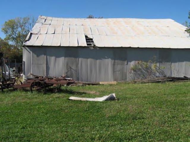
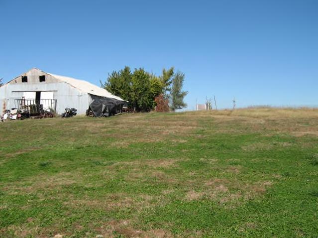
8 There are, at most, 13 structures within the Study Area by the most expansive interpretation of the term structure. While the TIF Statute does not define the term structure, the five houses within the Study Area are unequivocally structures. The three barns within the Study Area may also qualify as structures for purposes of the TIF Statute. While it is unclear whether small sheds or outhouses were intended under the TIF Statute to be included as structures, this study has taken the most conservative approach by including the five sheds/outhouses. Out of the aforementioned 13 components, 7 are definitively established as over 35 years old, 2 are established as less than 35 years old, and the age of four is unknown. All components and the parcel ID and address, age, and source of information regarding the age are shown on the chart and map below: Component Address Age Source Houses QF Maurer Road 1960 Johnson County Land Records QF Maurer Road 1960 Johnson County Land Records QP B 6707 Bell Road 1974 Johnson County Land Records QP C 6721 Bell Road 1963 Johnson County Land Records QP C 6720 Maurer Road 1981 Johnson County Land Records Barns QF Maurer Road Over 40 years Owner QF Maurer Road Over 40 years Owner QF Maurer Road Approx Owner Sheds QF Maurer Road Unknown QF Maurer Road Unknown QF Maurer Road Unknown QP B 6707 Bell Road Unknown QP C 6721 Bell Road Less than 20 years Owner 106


9 A photograph of each component is shown below Houses: QF /6552 Maurer Road 107
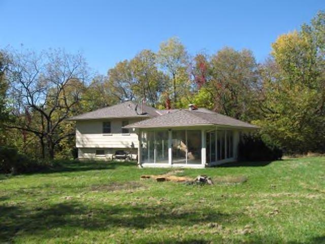

10 QF /6550 Maurer Road QP B/6707 Bell Road QP C/6721 Bell Road 108
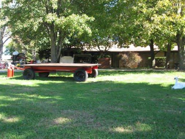
11 QP C/6720 Maurer Road Barns: QF /6552 Maurer Road QF /6552 Maurer Road 109
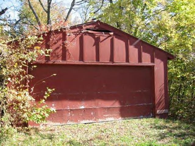

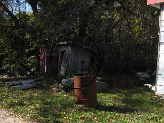
12 QF /6550 Maurer Road Sheds: QF /6552 Maurer Road QF /6552 Maurer Road 110


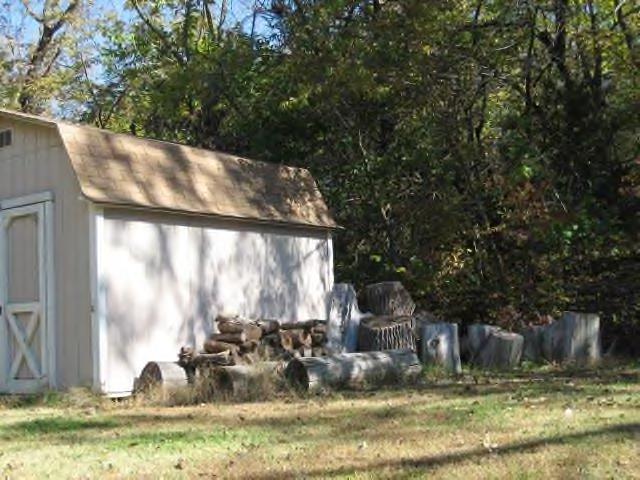
13 QF /6552 Maurer Road QP B/6707 Bell Road QP C/6721 Bell Road 111
, the definition of conservation area, is that the area is not yet blighted, but may become a blighted area due to the existence of a combination of two or more of the factors set forth in")

14 (c) The third requirement for conservation area designation, set forth in K.S.A a(d), the definition of conservation area, is that the area is not yet blighted, but may become a blighted area due to the existence of a combination of two or more of the factors set forth in such subparagraph, as set forth above. (1) Dilapidation, obsolescence or deterioration of the structures. Deteriorating and dilapidated structures predominate throughout the Study Area. Three of the five homes in the Study Area were built in the early 1960s, one was built in 1974, and one was built in All are in various stages of deterioration. The general upkeep of the exteriors of these residences is poor to fair. In addition to the deteriorating single-family residences, there are several dilapidated barns and sheds within the Study Area. The declining condition of these structures is evident upon visual examination examples are provided in the photographs below. Deteriorating/dilapidated structures: 112

15 113
16 114
17 115
 Overcrowding of structures and community facilities. None identified. (7) Inadequate infrastructure and utilities.")
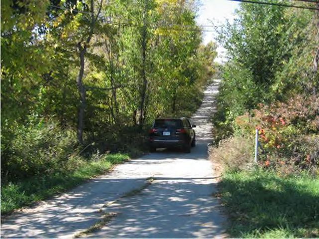
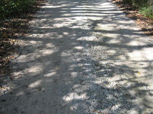
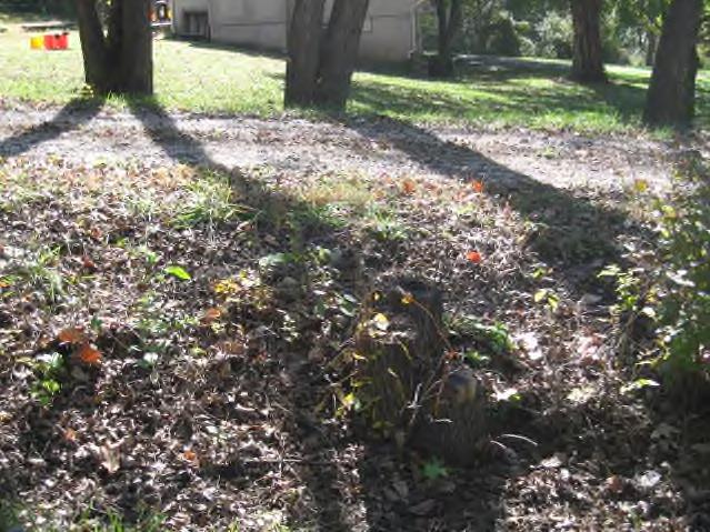
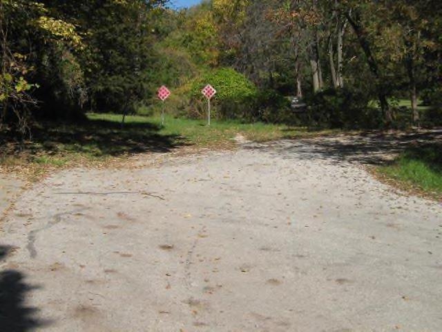
18 (2) Illegal use of individual structures. None identified. (3) The presence of structures below minimum code standards. None identified. (4) Building abandonment. None identified. (5) Excessive vacancies. None identified. (6) Overcrowding of structures and community facilities. None identified. (7) Inadequate infrastructure and utilities. The Study Area suffers from severe infrastructure and utility deficiencies. The infrastructure and utilities are inadequate for both the current suburban residential use of the Study Area as well as any type of future development. A. Inadequate Infrastructure 116 The only road within the Study Area is a single-lane gravel road without curbs and gutters. A narrow gravel road as the only ingress and egress for a residential development in a mature area of a large, suburban community, such as Shawnee, does not constitute adequate infrastructure, from a functional, safety, and aesthetics standpoint.
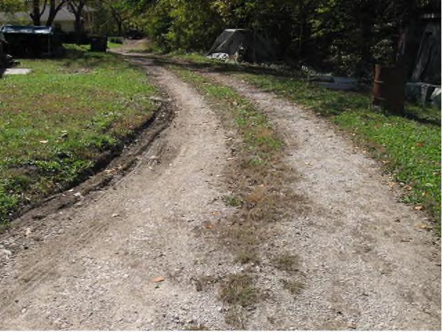
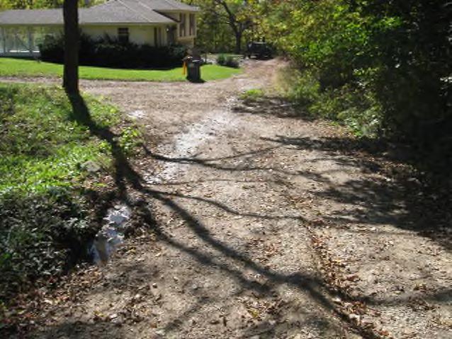
19 The condition of the gravel road is fair to poor in various areas, with deep grooves/indentations, mud and standing pools of water, lack of sufficient gravel, and narrow conditions with poor visibility due to overgrown trees and shrubs. The gravel road serves 7 of the 8 parcels within the Study Area but can be difficult and dangerous to use for ingress and egress from Maurer Road. o The eastern access point to the gravel road is from Maurer Road, a four-lane thoroughfare. There is no signage at the access point to the gravel road, no signalization, and the turn-off from Maurer immediately falls off in a very steep decline on the gravel road. o Leaving the Property from the gravel road onto Maurer can be dangerous given the poor visibility and high speeds of traffic heading southbound on Maurer. Delays during peak traffic hours can be experienced and encourage unsafe turning movements when leaving the Property. The gravel road, at its intersection with Maurer Road, provides the only proper access point for emergency vehicles to and from public streets (the only other potentially feasible access point for most of the Study Area entails traveling up Bell Road and over a private driveway in the southwest corner of the Study Area, which is not acceptable given that parked cars or other obstacles on the private driveway could slow or prevent first responders from timely reaching the Study Area from the south). Not only is such a single-point of ingress and egress for a cluster of residential homes not as safe as it should be, in a modern, suburban environment, it is also functionally inadequate for residents and their guests. Four parcels within the Study Area (6600 Maurer Road - QP , 6552 Maurer Road QF , 6550 Maurer Road QF , and QF ) are not directly served by any existing roads and thus have no direct access to public streets. In addition to the unnamed gravel road bisecting the Study Area, the house in the southeast corner of the Study Area has a gravel driveway and roundabout abutting Maurer Road. Residential access from such a busy street is insufficient and unsafe. Further, the primary street serving Home Depot and National Tire and Battery, West 67th Street, leads directly to and T s into the residential driveway without any signalization, further exacerbating the unsafe condition. No stormwater conveyance system exists. All stormwater is collected in ditches and natural swales that crisscross the Study Area. The inadequate street layout described above is shown in the map and pictures below: 117
20 Photographs of steep decline of access ramp from Maurer road on to gravel road and of inadequate gravel road infrastructure and access points: 118

21 119

22 120

23 121


24 Photographs of open drainage system: 122


25 B. Inadequate Utilities The Study Area lacks connection to a sanitary sewer system. For a mature, suburban environment such as exists currently along the Shawnee Mission Parkway corridor and in this part of the City generally, a septic system is inadequate. 123


26 A portion of the Study Area is serviced by water mains that do not meet modern standards. Specifically, the portion of the Study Area serviced by the water main located along Bell Road is serviced by a 6-inch main. A water main 6 inches wide for today s standards is subpar a water main serving a suburban residential area would typically be at least 8 inches in diameter. The implications of the undersized water main are water pressure issues for both residents and fire protection purposes. Utility components such as utility boxes and fire hydrants are in various stages of disrepair as shown in the photographs below. The Study Area is crisscrossed by low-hanging overhead power lines. Loose and excess wiring was observed trailing from the power lines and extending to ground level, and in many instances trees have grown into the lines. Loose wiring and low-hanging lines: 124
27 125
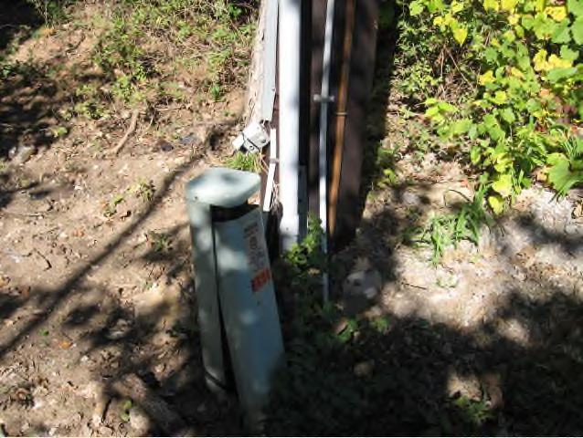

28 Deteriorating utility components: 126
29 II. Conclusion The Study Area meets the first and second requirements for designation as a conservation area set forth in K.S.A a(d), as it constitutes less than 15% of the area of the City of Shawnee and at least 50% of the structures in the area are at least 35 years old. The Study Area also meets at least two of the seven factors set forth in K.S.A a(d) for a conservation area designation, including: 1. Dilapidation, obsolescence or deterioration of structures. 2. Inadequate utilities and infrastructure. In conclusion, the Study Area satisfies the requirements for designation as a conservation area under the requirements of K.S.A a(d). 127
Downtown Meridian Urban Renewal Area URBAN RENEWAL ELIGIBILITY REPORT. Prepared for The City of Meridian and The Meridian Development Corporation
 Downtown Meridian Urban Renewal Area URBAN RENEWAL ELIGIBILITY REPORT Prepared for The City of Meridian and The Meridian Development Corporation by McKibben + Cooper Architects June 19, 2002 Authorization
TAX INCREMENT FINANCING REDEVELOPMENT PLAN & PROJECT
 TAX INCREMENT FINANCING REDEVELOPMENT PLAN & PROJECT... SOUTHWEST CORRIDORS REDEVELOPMENT PROJECT AREA. Prepared for: City of Collinsville, Illinois March 25, 2016 ST. LOUIS, MISSOURI TIF Redevelopment
Shawnee Landing TIF Project. City of Shawnee, Kansas. Need For Assistance Analysis
 Shawnee Landing TIF Project City of Shawnee, Kansas Need For Assistance Analysis December 17, 2014 Table of Contents 1 EXECUTIVE SUMMARY... 1 2 PURPOSE... 2 3 THE PROJECT... 3 4 ASSISTANCE REQUEST... 7
Delta Urban Renewal Authority Blight Study
 Delta Urban Renewal Authority Blight Study February 2017 1 Table of Contents 1. Introduction.3 1.1 Purpose..3 1.2 Colorado Urban Renewal Law..3 1.3 Study Methodology..5 2. Study Area Analysis.6 2.1 Study..6
Study Area Description Study Area Context Existing Land Use and Zoning Districts
 TABLE OF CONTENTS Table of Contents SECTION I: INTRODUCTION Definition of Blight Study Methodology Report Format SECTION II: AREA OVERVIEW AND DESCRIPTION Study Area Description Study Area Context Existing
9. REZONING NO Vicinity of the northwest corner of 143 rd Street and Metcalf Avenue
 9. REZONING NO. 2002-15 Vicinity of the northwest corner of 143 rd Street and Metcalf Avenue 1. APPLICANT: Andrew Schlagel is the applicant for this request. 2. REQUESTED ACTION: The applicant is requesting
Fannie Mae Fails to Maintain Foreclosures in African American and Latino Neighborhoods in Gary, Indiana
 Fannie Mae Fails to Maintain Foreclosures in African American and Latino Neighborhoods in Gary, Indiana South Suburban Housing Center 18220 Harwood Ave # 1, Homewood, IL 60430 John Petruszak, Executive
Hennepin County Department of. Housing, Community Works and Transit. Transit Oriented Development (TOD) Guidelines
 Guidelines") Hennepin County Department of Housing, Community Works and Transit 2007 Transit Oriented Development (TOD) Guidelines Hennepin County Transit Oriented Development (TOD) Bond Funds Hennepin County Housing,
Hennepin County Department of Housing, Community Works and Transit 2007 Transit Oriented Development (TOD) Guidelines Hennepin County Transit Oriented Development (TOD) Bond Funds Hennepin County Housing,
Blight and Substandard Study City of Blair, Nebraska
 Blight and Substandard Study City of Blair, Nebraska 2014 JEO Consulting Group, Inc. Project No. 131365.00 Adopted, 2014 Resolution No. Introduction Introduction Purpose of the Study This Blair Blight
ARTICLE 900 PLAT AND PLAN REQUIREMENTS
 ARTICLE 900 PLAT AND PLAN REQUIREMENTS SEC. 900.1 ITEMS TO BE SHOWN ON PLAT OR PLAN General (1) Property lines of all property owners adjacent to the exterior boundaries of the project shall be located
Fannie Mae Fails to Maintain its Foreclosure Inventory in Communities of Color
 Fannie Mae Fails to Maintain its Foreclosure Inventory in Communities of Color Connecticut Fair Housing Center Erin Kemple, Executive Director May 13, 2015 Introduction Connecticut Fair Housing Center
4.2 RESIDENTIAL ZONING DISTRICTS
 4.2 RESIDENTIAL ZONING DISTRICTS A. Purpose: To define regulations and standards for each residential zoning district in the City. The following sections identify uses, regulations, and performance standards
Section 1: US 19 Overlay District
 Section 1: US 19 Overlay District Section 1.1 Intent and Purpose The purpose of the US Highway 19 Overlay District is to manage access to land development along US Highway 19 in a manner that preserves
Deed Restrictions & Modifications 4704 VOL. 38 PAGES 809 & 810
 Deed Restrictions & Modifications 4704 VOL. 38 PAGES 809 & 810 EXHIBIT B RESTRICTIONS 1. All lots in said subdivision shall be known and described as a single family residential lots, and no more than
PLANNING COMMISSION REPORT REGULAR AGENDA
 PP-4-4-11 Item No. 9-1 PLANNING COMMISSION REPORT REGULAR AGENDA PC Staff Report 06/22/11 ITEM NO 9: PRELIMINARY PLAT; KASOLD WATER TOWER ADDITION; SE OF TAM O SHANTER & KASOLD DR (MKM) PP-4-4-11: Consider
Downtown & East Town CRA Expansion Plan City of Eustis
 Downtown & East Town CRA Expansion Plan City of Eustis May 2018 Contents 1 Introduction... 1 CRA Overview/History... 1 2 Existing Conditions... 2 Downtown & East Town Community Redevelopment Area Expansion...
THE REDEVELOPMENT PLAN
 PAGE 37 THE REDEVELOPMENT PLAN FUTURE LAND USE The Silver Terrace Redevelopment Area is currently designated as Redevelopment Area #4 on the City of Delray Beach Future Land Use Map (FLUM). This designation
REZONING GUIDE. Zone Map Amendment (Rezoning) - Application. Rezoning Application Page 1 of 3. Return completed form to
 - Application. Rezoning Application Page 1 of 3. Return completed form to") Zone Map Amendment (Rezoning) - Application COMMUNITY PLANNING & DEVELOPMENT REZONING GUIDE Rezoning Application Page 1 of 3 PROPERTY OWNER INFORMATION* CHECK IF POINT OF CONTACT FOR APPLICATION Property
Zone Map Amendment (Rezoning) - Application COMMUNITY PLANNING & DEVELOPMENT REZONING GUIDE Rezoning Application Page 1 of 3 PROPERTY OWNER INFORMATION* CHECK IF POINT OF CONTACT FOR APPLICATION Property
City of Exeter Housing Element
 D. Housing Stock Characteristics Government Code Section 65583(a) requires an analysis and documentation of household characteristics, including level of payment compared to ability to pay, housing characteristics,
Wampus Mills Subdivision, Tree Removal Permit and Steep Slope Permit Approvals [#14-103]
![Wampus Mills Subdivision, Tree Removal Permit and Steep Slope Permit Approvals [#14-103]](/thumbs/95/122755150.jpg "Wampus Mills Subdivision, Tree Removal Permit and Steep Slope Permit Approvals [#14-103]") TOWN OF NORTH CASTLE WESTCHESTER COUNTY 17 Bedford Road Armonk, New York 10504-1898 PLANNING DEPARTMENT Adam R. Kaufman, AICP Director of Planning Telephone: (914) 273-3542 Fax: (914) 273-3554 www.northcastleny.com
TOWN OF NORTH CASTLE WESTCHESTER COUNTY 17 Bedford Road Armonk, New York 10504-1898 PLANNING DEPARTMENT Adam R. Kaufman, AICP Director of Planning Telephone: (914) 273-3542 Fax: (914) 273-3554 www.northcastleny.com
Westerly Creek Village Conditions Inventory and Environmental Assessment A U R O R A
 Westerly Creek Village Conditions Inventory and Environmental Assessment A U R O R A Table of Contents Section 1: Study Overview... 1 Section 2: Colorado Urban Renewal Statutes and Blighted Areas... 3
R E S O L U T I O N. 2. Development Data Summary
 R E S O L U T I O N WHEREAS, the Prince George's County Planning Board is charged with the approval of Detailed Site Plans pursuant to Part 3, Division 9 of the Zoning Ordinance of the Prince George's
Rezoning Petition Final Staff Analysis May 21, 2018
 Rezoning Petition 2017-182 Final Staff Analysis May 21, 2018 REQUEST LOCATION Current Zoning: R-3 (single family) and no zoning (current NC State right-of-way) Proposed Zoning: B-2(CD) (general business,
40 +/- Acres Cornerstone Group- Colonial Boulevard 40 Acres Section 32, Township 44, Range 25. For Cornerstone Group. Prepared by
 DUE DILIGENCE REPORT 40 +/- Acres Cornerstone Group- Colonial Boulevard 40 Acres Section 32, Township 44, Range 25 For Cornerstone Group Prepared by David Douglas Associates, Inc. 2037 West First Street
Proposed Overland Park Kansas Ordinance RE-1 Residential Estates Community
 18.171 RE-1 Residential Estate Community 18.171.010 Statement of intent. The zoning of property as RE-1, (Residential Estates Community, 1 dwelling unit per Gross acre density), is intended to provide
Tax Increment Financing District Eligibility Study and Redevelopment Plan and Project
 WOOD DALE, IL Wood Dale Road Redevelopment Project Area Tax Increment Financing District Eligibility Study and Redevelopment Plan and Project March 1, 2018 S. B. FRIEDMAN & COMPANY 221 N. LaSalle St. Suite
A PRELIMINARY FINANCIAL AND ECONOMIC REDEVELOPMENT FEASIBILITY STUDY FOR THE CITY OF FERNLEY, NEVADA
 TECHNICAL REPORT UCED 2015/16-07 A PRELIMINARY FINANCIAL AND ECONOMIC REDEVELOPMENT FEASIBILITY STUDY FOR THE CITY OF FERNLEY, NEVADA UNIVERSITY OF NEVADA, RENO A PRELIMINARY FINANCIAL AND ECONOMIC REDEVELOPMENT
NEC K-7 & Shawnee Mission Parkway
 FIRST TIME OFFERING 68+/- Acres of Prime Development Land For Sale: NEC K-7 & Shawnee Mission Parkway Shawnee, Johnson County, KS Supporting Land Use Information & Data INTRODUCTION CONTEXT Location: The
Initial Project Review
 Pierce County Department of Planning and Land Services, 2401 South 35th Street, Tacoma, WA (253) 798-7037 Initial Project Review Major Amendment to Preliminary Plat: Hawks Ridge Division 1 Application
Fannie Mae Fails to Maintain REOs in African- American and Latino Neighborhoods in New Orleans and Baton Rouge, LA
 Fannie Mae Fails to Maintain REOs in African- American and Latino Neighborhoods in New Orleans and Baton Rouge, LA Greater New Orleans Fair Housing Action Center 404 S. Jefferson Davis Pkwy New Orleans,
Town of Cary, North Carolina Site Plan Staff Report Centregreen Park at Weston (13-SP-067) Town Council Quasi-Judicial Hearing April 3, 2014
 Town Council Quasi-Judicial Hearing April 3, 2014") Town of Cary, North Carolina Site Plan Staff Report Centregreen Park at Weston (13-SP-067) Town Council Quasi-Judicial Hearing April 3, 2014 REQUEST Withers and Ravenel, on behalf of Highwoods Realty Limited
Town of Cary, North Carolina Site Plan Staff Report Centregreen Park at Weston (13-SP-067) Town Council Quasi-Judicial Hearing April 3, 2014 REQUEST Withers and Ravenel, on behalf of Highwoods Realty Limited
Hamilton County Regional Planning Commission
 Hamilton County Regional Planning Commission March 1, 2012 Colerain Township Staff Report Zone Map Amendment: Case No.: ZA2012-01 Joseph Toyota Prepared By: Amy Bancroft, Land Use Planner ACTION REQUESTED:
Short Title: Performance Guarantees/Subdivision Streets. (Public) April 28, 2016
 April 28, 2016") GENERAL ASSEMBLY OF NORTH CAROLINA SESSION S SENATE BILL Transportation Committee Substitute Adopted // House Committee Substitute Favorable // Fourth Edition Engrossed // Short Title: Performance Guarantees/Subdivision
GENERAL ASSEMBLY OF NORTH CAROLINA SESSION S SENATE BILL Transportation Committee Substitute Adopted // House Committee Substitute Favorable // Fourth Edition Engrossed // Short Title: Performance Guarantees/Subdivision
DAUPHIN CREEK ESTATES SUBDIVISION
 # 12 SUB-000076-2017 DAUPHIN CREEK ESTATES SUBDIVISION Engineering Comments: FINAL PLAT COMMENTS (should be addressed prior to submitting the FINAL PLAT for review and/or signature by the City Engineer):
COUNTY OF LINCOLN, NORTH CAROLINA
 COUNTY OF LINCOLN, NORTH CAROLINA 302 NORTH ACADEMY STREET, SUITE A, LINCOLNTON, NORTH CAROLINA 28092 PLANNING AND INSPECTIONS DEPARTMENT 704-736-8440 OFFICE 704-732-9010 FAX To: George Wood, county manager
MINUTES CITY OF ORMOND BEACH QUALITY OF LIFE ADVISORY BOARD REGULAR MEETING
 MINUTES CITY OF ORMOND BEACH QUALITY OF LIFE ADVISORY BOARD REGULAR MEETING April 1, 2015 6:00 PM City of Ormond Beach Training Room 22 South Beach Street Ormond Beach, Florida 1) Call to Order Dr. Shapiro
Fannie Mae Fails to Maintain its Foreclosure Inventory in Communities of Color in Richmond, Oakland, and Vallejo, CA
 Fannie Mae Fails to Maintain its Foreclosure Inventory in Communities of Color in Richmond, Oakland, and Vallejo, CA Fair Housing Advocates of Northern California 1314 Lincoln Ave. Suite A San Rafael,
CHARLES CITY COUNTY SITE PLAN ORDINANCE. This Ordinance shall be known as the Charles City County Site Plan Ordinance.
 CHARLES CITY COUNTY SITE PLAN ORDINANCE Section 1. Title This Ordinance shall be known as the Charles City County Site Plan Ordinance. Section 2. Authority. This Ordinance is enacted pursuant to the authority
COUNTY OF EL DORADO DEVELOPMENT SERVICES PLANNING COMMISSION STAFF REPORT TENTATIVE MAP
 COUNTY OF EL DORADO DEVELOPMENT SERVICES PLANNING COMMISSION STAFF REPORT Agenda of: June 27, 2013 Item No.: 9.a Staff: Mel Pabalinas TENTATIVE MAP FILE NUMBER: APPLICANT: REQUEST: LOCATION: TM10-1501/West
CITY OF ELMHURST TIF QUALIFICATION REPORT NORTH YORK STREET TIF DISTRICT
 Draft dated 03/14/12 CITY OF ELMHURST TIF QUALIFICATION REPORT NORTH YORK STREET TIF DISTRICT A study to determine whether all or a portion of an area located in the City of Elmhurst qualifies as a conservation
TAX INCREMENT FINANCING PLAN PARAGON STAR, LLC
 TAX INCREMENT FINANCING PLAN PARAGON STAR, LLC JANUARY 6, 2016 FEBRUARY 17, 2016 1 TABLE OF CONTENTS I. DEFINITIONS 4 II. TAX INCREMENT FINANCING 6 III. GENERAL DESCRIPTION OF REDEVELOPMENT PLAN AND PROJECT
Spirit Lake North, LLC
 BONNER COUNTY PLANNING DEPARTMENT PLANNING AND ZONING COMMISSION STAFF REPORT FOR March 1, 2018 Project Name: Amendment & Zone Change: Spirit Lake North, LLC File Number,Type: AM 162-18/ZC365-18 Request:
STANDARDIZED LEGAL DESCRIPTIONS AND EXHIBITS
 STANDARDIZED LEGAL DESCRIPTIONS AND EXHIBITS Public Works Department, Engineering Division June 14, 2004 UNIFIED GOVERNMENT STANDARDIZED LEGAL DESCRIPTIONS AND EXHIBITS For: Roads, Bridges, Short Span
Fannie Mae Fails to Maintain Foreclosures in African American and Latino Neighborhoods in Grand Rapids and Muskegon, MI
 Fannie Mae Fails to Maintain Foreclosures in African American and Latino Neighborhoods in Grand Rapids and Muskegon, MI Fair Housing Center of West Michigan 20 Hall Street SE Grand Rapids, Michigan 49507
Address Southeast Quadrant of U.S. Highway 41 and Sumter Boulevard City. North Port State. FL Zip Code County
 SUBJECT AERIAL LOCATION LAND AREA THREE-YEAR OWNERSHIP HISTORY OF SUBJECT Address Southeast Quadrant of U.S. Highway 41 and Sumter Boulevard City North Port State FL Zip Code 34287 County Sarasota Nearest
PLANNING BOARD AGENDA Disposition Agenda
 PLANNING BOARD AGENDA Disposition Agenda Public Hearing and Administrative Meeting Wednesday,, 1:30 P.M. Omaha/Douglas Civic Center 1819 Farnam Street Legislative Chamber Planning Board Members: Greg Rosenbaum,
PARK DISTRICT DEVELOPMENT AGREEMENT
 PARK DISTRICT DEVELOPMENT AGREEMENT This Development Agreement (the Agreement ) is made this day of 2017, by and between the CITY OF EAST LANSING, a Michigan municipal corporation, with its offices at
City of Lawrence Neighborhood Revitalization Plan and Program: 1101/1115 Indiana Street Lawrence, KS
 City of Lawrence Neighborhood Revitalization Plan and Program: 1101/1115 Indiana Street Lawrence, KS Definition: Area - used interchangeably with Property, referring to the property located at 1101/1115
URBAN REVITALIZATION PLAN CITY OF DECORAH, IOWA 2014 DECORAH HOUSING URBAN REVITALIZATION AREA ADOPTED NOVEMBER 3, 2014
 URBAN REVITALIZATION PLAN CITY OF DECORAH, IOWA 2014 DECORAH HOUSING URBAN REVITALIZATION AREA ADOPTED NOVEMBER 3, 2014 Public Hearing held September 2, 2014 Second Public Hearing held October 6, 2014
Fannie Mae Fails to Maintain Foreclosures in African American and Latino Neighborhoods
 Fannie Mae Fails to Maintain Foreclosures in African American and Latino Neighborhoods ALBUQUERQUE, NEW MEXICO National Fair Housing Alliance 1101 Vermont Avenue, NW, Suite 710 Washington, DC 20008 www.nationalfairhousing.org
ARTICLE 23 CONDOMINIUM STANDARDS
 ARTICLE 23 CONDOMINIUM STANDARDS Section 23.01 Intent. The intent of this Article is to provide regulatory standards for condominiums and site condominiums similar to those required for projects developed
PLANNING COMMISSION REPORT Regular Agenda Public Hearing Item
 CUP-15-00474 Item No. 5-1 PC Staff Report 11/16/15 ITEM NO. 5 PLANNING COMMISSION REPORT Regular Agenda Public Hearing Item CONDITIONAL USE PERMIT FOR PUBLIC WHOLESALE WATER SUPPLY DISTRICT NO. 25; E 1300
PLANNING & ZONING DEPARTMENT Town Hall Annex, 66 Prospect St., Ridgefield, CT Fax
 PLANNING & ZONING DEPARTMENT Town Hall Annex, 66 Prospect St., Ridgefield, CT 06877 203-431-2766 Fax 203-431-2737 ADOPTED AMENDMENT TO THE ZONING REGULATIONS NEW Section 5.6 Neighborhood Business Zone
ZONING AMENDMENT STAFF REPORT Date: September 15, 2016
 ZONING AMENDMENT STAFF REPORT Date: September 15, 2016 NAME LOCATION Clear Water, LLC 3490 Hurricane Bay Road (Northeast corner of Hurricane Bay Road and Hurricane Bay Lane) CITY COUNCIL DISTRICT District
QUESTIONS FROM WESTWOOD HILLS HOME OWNERS ASSOCIATION. Queens Road Q&A
 QUESTIONS FROM WESTWOOD HILLS HOME OWNERS ASSOCIATION Queens Road Q&A Many questions are focused around how and why the boundaries are established for a benefit district. The statute (KSA 12-6a01 et seq.)
Scales Mound Redevelopment Project Area Tax Increment Financing District Eligibility Study, Redevelopment Plan and Project
 Scales Mound Redevelopment Project Area Tax Increment Financing District Eligibility Study, Redevelopment Plan and Project Village of Scales Mound, Illinois DRAFT SUBMITTED: October 2012 Table of Contents
New Private Way Ordinance Westbrook Planning Board Workshop , Planning Board Public Hearing Definitions
 201 Definitions Private Right of Way; Private way A strip of land at least fifty feet wide, meeting the minimum standards for the construction of a gravel base for a public road, over which abutters may
APPENDIX 7 SPECIAL NOTES FOR PLATS AND CONSTRUCTION PLANS
 APPENDIX 7 SPECIAL NOTES FOR PLATS AND CONSTRUCTION PLANS EASEMENT AND DRAINAGE STATEMENT TO BE PLACED ON PLANS AND ALL SUBDIVISION PLATS REQUIRING SOIL DRAINAGE MANAGEMENT PLANS The easements designated
City of. Moultrie. Urban Redevelopment Plan
 City of Moultrie Urban Redevelopment Plan Table of Contents Introduction... 3 Redevelopment Goals and Objectives... 4 Consistency with the Comprehensive Plan... 5 Community s Land use Objectives... 6 Boundaries
3. Will there be any amenities provided for the apartment or townhouse area, such as play areas or trails?
 .._ - Cityof Maple Grove MEMORANDUM TO: FROM: Elm Creek Estates File Dick Edwards, Community Development Director DATE: December 27,2016 SUBJECT: Community Development Staff Comments 1. Code requires a
Report to the Plan Commission February 4, 2013
 Report to the Plan Commission Legistar I.D. #28789 Conditional Use Requested Actions: Approval of a conditional use for a structure exceeding 10,0000 square feet of total floor area and an accessory building
The Maryland-National Capital Park and Planning Commission Prince George's County Planning Department Development Review Division
 The Maryland-National Capital Park and Planning Commission Prince George's County Planning Department Development Review Division 301-952-3530 Note: Staff reports can be accessed at www.mncppc.org/pgco/planning/plan.htm.
the Comprehensive Plan and local land development regulations.
 RESOLUTION NO. R-90-522 RESOLUTION APPROVING ZONING PETITION NO. 87-103(B) SPECIAL EXCEPTION PETITION OF ADAMHILL FINANCIAL CORPORATION WHEREAS, the Board of County Commissioners, as the governing body,
1 February 8, 2012 Public Hearing APPLICANT: ERNEST D. PARRISH
 REQUEST: Conditional Use Permit (Truck and Trailer Rental) 1 February 8, 2012 Public Hearing APPLICANT: ERNEST D. PARRISH PROPERTY OWNER: ACT B LYNNHAVEN COLONY SHOPS STAFF PLANNER: Faith Christie ADDRESS
PLANNING RATIONALE ONTARIO LTD. APLLICATION FOR PLAN OF SUBDIVISION APPROVAL
 PLANNING RATIONALE 1384341 ONTARIO LTD. APLLICATION FOR PLAN OF SUBDIVISION APPROVAL PART OF LOTS 18 & 19, CONCESSION 1 GEOGRAPHIC TOWNSHIP OF MARCH NOW IN CITY OF OTTAWA FEBRUARY 2013 1 Planning Rationale
Presence-Saint Joseph Medical Center Area Redevelopment Project Area
 CITY OF JOLIET, IL Presence-Saint Joseph Medical Center Area Redevelopment Project Area Tax Increment Financing Eligibility Study and Redevelopment Plan and Project November 2, 2016 CITY OF JOLIET, IL
Community Development Department 333 Broadalbin Street SW, P.O. Box 490 Albany, OR 97321
 SUMMARY Community Development Department 333 Broadalbin Street SW, P.O. Box 490 Albany, OR 97321 STAFF REPORT Application for Tentative Partition Plat Review Planning File PA-06-17 Phone: 541-917-7550
TITLE 7. MUNICIPAL IMPROVEMENTS AND PUBLIC SERVICE PROJECTS
 MUNICIPAL IMPROVEMENTS AND PUBLIC SERVICE PROJECTS 7-1 TITLE 7. MUNICIPAL IMPROVEMENTS AND PUBLIC SERVICE PROJECTS CHAPTER 7-100. FREEWAY INTER- CHANGE DEVELOPMENT PLAN - REPORT. This report on the project
L. LAND USE. Page L-1
 L. LAND USE 1. Purpose This section discusses current and likely future land use patterns in Orland. An understanding of land use trends is very important in determining Orland's ability to absorb future
HERON LANDING SUBDIVISION
 HERON LANDING SUBDIVISION Engineering Comments: Per FEMA guidelines, any development greater than 5 acres in size or subdivision 50 lots in size, requires a flood study. Width of drainage easement to be
ARTICLE 900 PLAT AND PLAN REQUIREMENTS
 Final SEC. 900.01 ARTICLE 900 PLAT AND PLAN REQUIREMENTS General provisions. (a) Scale. The scale of all plats and plans shall be a minimum of 1 to 100 ft. (b) Size. The minimum page size for all plats
DEKALB CENTRAL BUSINESS DISTRICT Redevelopment Project Area
 CITY OF DEKALB, IL DEKALB CENTRAL BUSINESS DISTRICT Redevelopment Project Area Tax Increment Financing District Eligibility Study, Redevelopment Plan and Project, and Housing Impact Study June 4, 2018
FINAL DRAFT 12/1/16, Rev. to 7/18/17
 FINAL DRAFT 12/1/16, Rev. to 7/18/17 (As Adopted 8/8/17 Effective 9/1/17) SHELTON PLANNING AND ZONING COMMISSION Proposed Amendments to Zoning Regulations I. Amend Section 23 PERMITTED USES by inserting
DATE: February 28, Marilynn Lewis, Principal Planner
 DATE: February 28, 2007 TO: FROM: RE: Salt Lake City Planning Commission Marilynn Lewis, Principal Planner Planning Commission Hearing for Petition 400-06-41 Zoning Map Amendment to Rezone 6 Properties,
Bowie Marketplace Residential Detailed Site Plan Statement of Justification January 13, 2017 Revised February 2, 1017
 Bowie Marketplace Residential Detailed Site Plan Statement of Justification January 13, 2017 Revised February 2, 1017 Submitted on behalf of: BE Bowie LLC 5410 Edson Lane, Suite 220 Rockville, MD 20852
July 1, 2014 thru September 30, 2014 Performance Report
 Grantee: Grant: Broward County FL B-11-UN-12-0002 July 1 2014 thru September 30 2014 Performance Report 1 Grant Number: B-11-UN-12-0002 Grantee Name: Broward County FL Grant Award Amount: $5457553.00 LOCCS
Urban Design Brief. Proposed Medical / Dental Office 1444 Adelaide Street North. Vireo Health Facility Ltd.
 Urban Design Brief Proposed Medical / Dental Office Vireo Health Facility Ltd. November 27, 2013 TABLE OF CONTENTS Page No. INTRODUCTION... 1 SECTION 1 LAND USE PLANNING CONTEXT... 1 1.1 The Subject Lands...
CLARK COUNTY NEIGHBORHOOD REVITALIZATION PLAN. Effective Date. January 1, Revised
 CLARK COUNTY NEIGHBORHOOD REVITALIZATION PLAN Effective Date January 1, 2007 Revised January 1, 2010 KANSAS NEIGHBORHOOD REVITALIZATION ACT K.S.A. 1996 Supp. 12-17, 114 et seq. This law authorizes any
1~1~ 1i i11mmi ~m
 1~1~ 1i1111111111i11mmi111111111~m 20180521-0006702 5/ 21/ 2018 Pages: 10 F : $0. 00 2 : 11 PM Register of Deeds T20180026529 COVER SHEET TITLE OF DOCUMENT: Ordinance No. 18-17 (Creation of The Olathe
Public Facilities and Finance Element
 This Element of the General Plan addresses the following public facilities issues: Water Service, including both potable (drinkable) and non-potable water delivery. Sewer Service, and Financing and construction
Report to the Plan Commission December 19, 2011
 Report to the Plan Commission Legistar I.D. #24825, Extraterritorial Certified Survey Map Requested Action: Consideration of a two-lot Certified Survey Map (CSM) of the Keryluk-Wee property located at,,
AN ORDINANCE AMENDING THE CITY ZONING ORDINANCE AND THE OFFICIAL CODE OF THE CITY OF CLARKSVILLE RELATIVE TO CLUSTER OPTION DEVELOPMENTS
 ORDINANCE 74-2012-13 AN ORDINANCE AMENDING THE CITY ZONING ORDINANCE AND THE OFFICIAL CODE OF THE CITY OF CLARKSVILLE RELATIVE TO CLUSTER OPTION DEVELOPMENTS BE IT ORDAINED BY THE CITY COUNCIL OF THE CITY
Action Recommendation: Budget Impact:
 City of Fayetteville Staff Review Form 2018-0744 Legistar File ID 1/3/2019 City Council Meeting Date - Agenda Item Only N/A for Non-Agenda Item Garner Stoll 12/14/2018 CITY PLANNING (630) Submitted By
Individual Well Individual Septic. Community Well 19. What is the proposed method of sewage disposal? Public. None
 Please Answer the Following Questions: (attach sheet if needed). What type of facility is being proposed? Campground Recreational Vehicle (RV) Park Both 2. What is the total acreage of the proposed facility?
Fannie Mae Fails to Maintain its Foreclosure Inventory in Communities of Color in Richmond, VA
 Fannie Mae Fails to Maintain its Foreclosure Inventory in Communities of Color in Richmond, VA HOME: Housing Opportunities Made Equal of Virginia 626 E Broad St #400, Richmond, VA 23219 Heather Mullins
DOUGLAS COUNTY ZONING RESOLUTION Section 4 LRR - Large Rural Residential District 3/10/99. -Section Contents-
 SECTION 4 LRR LARGE RURAL RESIDENTIAL DISTRICT -Section Contents- 401 Intent... 4-2 402 Principal Uses... 4-2 403 Accessory Uses... 4-3 404 Uses Permitted by Special Review... 4-4 405 Land Dedication...
. Excellent location near Kansas Speedway/Village
 FOR SALE 220 Acres Master Planned Multifamily and Commercial Near Kansas Speedway Kansas Highway 7 126th Street SITE State Avenue The Plaza at Village West Legends Outlets Community America Ballpark Sporting
PLANNED UNIT DEVELOPMENT (East), PLANNED UNIT DEVELOPMENT (West) STAFF REPORT Date: September 18, 2014
, PLANNED UNIT DEVELOPMENT (West) STAFF REPORT Date: September 18, 2014") PLANNED UNIT DEVELOPMENT (East), PLANNED UNIT DEVELOPMENT (West) STAFF REPORT Date: September 18, 2014 DEVELOPMENT NAME LOCATION McGowin Park, LLC PLANNED UNIT DEVELOPMENT (East) 1401 Satchel Paige Drive
PLANNED UNIT DEVELOPMENT (East), PLANNED UNIT DEVELOPMENT (West) STAFF REPORT Date: September 18, 2014 DEVELOPMENT NAME LOCATION McGowin Park, LLC PLANNED UNIT DEVELOPMENT (East) 1401 Satchel Paige Drive
A. Preserve natural resources as identified in the Comprehensive Plan.
 1370.08 Conservation Residential Overlay District. Subd. 1 Findings. The City finds that the lands and resources within the Conservation Residential Overlay District are a unique and valuable resource
City of Grande Prairie Development Services Department
 City of Grande Prairie Development Services Department COUNTRYSIDE SOUTH OUTLINE PLAN Prepared by: GPEC Consulting Ltd. #202, 10712-100th Street Grande Prairie, AB Council Resolution of August 20, 2001
Affordable Housing Plan
 Affordable Housing Plan CORDOVA HILLS SPECIAL PLANNING AREA 1 Proposed Project Conwy LLC is the master developer ( Master Developer ) of that certain real property in the County of Sacramento ( County
22 March 14, 2012 Public Hearing APPLICANTS/ PROPERTY OWNERS: SOUTHGATE COMMONS, LLC & HOLLOMAN BROWN FUNERAL HOME,INC.
 22 March 14, 2012 Public Hearing APPLICANTS/ PROPERTY OWNERS: SOUTHGATE COMMONS, LLC & HOLLOMAN BROWN FUNERAL HOME,INC. STAFF PLANNER: Karen Prochilo REQUEST: Conditional Change of Zoning (AG-1 & AG-2
Article 7: Residential Land Use and Development Requirements
 Article 7: Residential Land Use and Section 701: Statement of Intent (A) (B) (C) The intent of Article 7 is to develop certain land use and development requirements for the residential uses within Cumru
EDMOND PLANNING COMMISSION MEETING. Tuesday, October 5, 2004
 124 EDMOND PLANNING COMMISSION MEETING Tuesday, 5:30 P.M. The Edmond Planning Commission Meeting was called to order by Chairperson David Woods at 5:30 p.m., Tuesday,, in the City Council Chambers at 20
Looking at Quality of Life Issues from an Enforcement Perspective. What s s on the full plate? How can we work together?
 Looking at Quality of Life Issues from an Enforcement Perspective What s s on the full plate? How can we work together? What Are We All Looking For? A good quality of life? Healthy and productive communities
HOUSING ELEMENT I. GOALS, OBJECTIVES AND POLICIES
 HOUSING ELEMENT I. GOALS, OBJECTIVES AND POLICIES GOAL 1: IN ORDER TO ACHIEVE A BALANCED HOUSING SUPPLY (AND A BALANCED POPULATION AND ECONOMIC BASE), EVERY EFFORT SHOULD BE MADE TO PROVIDE A BROAD RANGE
Lawrence SmartCode Infill Plan
 HORIZON 2020 THE COMPREHENSIVE PLAN FOR LAWRENCE AND UNINCORPORATED DOUGLAS COUNTY Lawrence SmartCode Infill Plan Incorporated By Reference Pursuant to K.S.A. 12-3009, et seq. K.S.A. 12-3301 et seq. and
MINUTES PLANNING AND ZONING COMMISSION FEBRUARY 9, 2016 REGULAR MEETING
 MINUTES PLANNING AND ZONING COMMISSION FEBRUARY 9, 2016 REGULAR MEETING The Planning and Zoning Commission conducted its February 9, 2016, Regular Meeting in the Council Chambers of City Hall (1900 Billy
RS9 LB-S RSQ-S RS9 RS9 DOCKET: W2822 PROPOSED ZONING: LB EXISTING ZONING: RS-9. PETITIONER: J&J Properties of W-S, LLC, for property owned by Same
 HAYMOUNT ST RS9 IP DOCKET: W2822 PROPOSED ZONING: LB POPE RD CLEMMONSVILLE RD EXISTING ZONING: RS-9 RSQ-S LB-S OLD SALISBURY RD WINSTON-SALEM ZONING FORSYTH COUNTY ZONING PETITIONER: J&J Properties of
Fannie Mae Fails to Maintain Foreclosures in Communities of Color in Columbus, Ohio
 Fannie Mae Fails to Maintain Foreclosures in Communities of Color in Columbus, Ohio The Central Ohio Fair Housing Association Jim McCarthy, President/CEO 175 South 3rd Street, Suite 580 Columbus, OH 43215