PLANNING & ZONING COMMISSION AGENDA: JUNE 16,2016
|
|
|
- Geraldine Casey
- 6 years ago
- Views:
Transcription
1 PLANNNG & ZONNG COMMSSON AGENDA: JUNE 16,2016
2 CTY OF LAREDO PLANNNG AND ZONNG COMMSSON NOTCE OF MEETNG THURSDAY. JUNE DSABLTY ACCESS STATEMENT Persons with disabilities who plan to attend this meeting and who may need auxiliary aid or services are requested to contact Ana G. Villarreal, Planner, at (956) at least two working days prior to the meeting so that appropriate arrangements can be made. The accessible entrance and accessible parking spaces are located at City Hall, 00 Victoria Ave. Out of consideration for all attendees of the Planning and Zoning Commission meetings, please tum off all cellular phones and pagers, or place on inaudible signal. Thank you for your consideration. Pursuant to the Texas Penal Code (trespass by holder oflicense to carry a handgun), a person licensed under Subchapter H, Chapter 411, Government Code (Concealed Handgun Law or Handgun Licensing Law), may not enter into the City Council Chamber while the Planning and Zoning Commission is in session with a concealed or openly-carried handgun. The City of Laredo Planning and Zoning Commission will convene in regular session open to the public at 6:00p.m. on Thursday, June 16, 2016 in the City Council Chambers at City Hall, 1110 Houston Street, Laredo, Texas to consider the following:. CALL TO ORDER. ll. V. ROLL CALL PLEDGE OF ALLEGANCE CONSDER APPROVAL OF MNUTES OF: A. Regular meeting of May 19, 2016 B. Regular meeting ofjune 2, 2016 V. CHARMAN AND DRECTORS REPORT AND COMMUNCATONS: CTZEN COMMENTS Citizens are required to fill out a witness card and submit it to a City Planner, or designee, no later than 5:45 p.m. and identify themselves at the microphone. Comments are limited to three (3) minutes per speaker. No more than three (3) persons will be allowed to speak on any side of an issue. Should there be more than three (3) people who wish to speak on a particular issue, they need to select not more than three (3) representatives to speak for them and the presiding officer may limit the public comments further in the interest of an orderly meeting. Speakers may not pass their minutes to any other speaker. Comments should be relevant to City business and delivered in a professional manner. No derogatory remarks will be permitted. Page
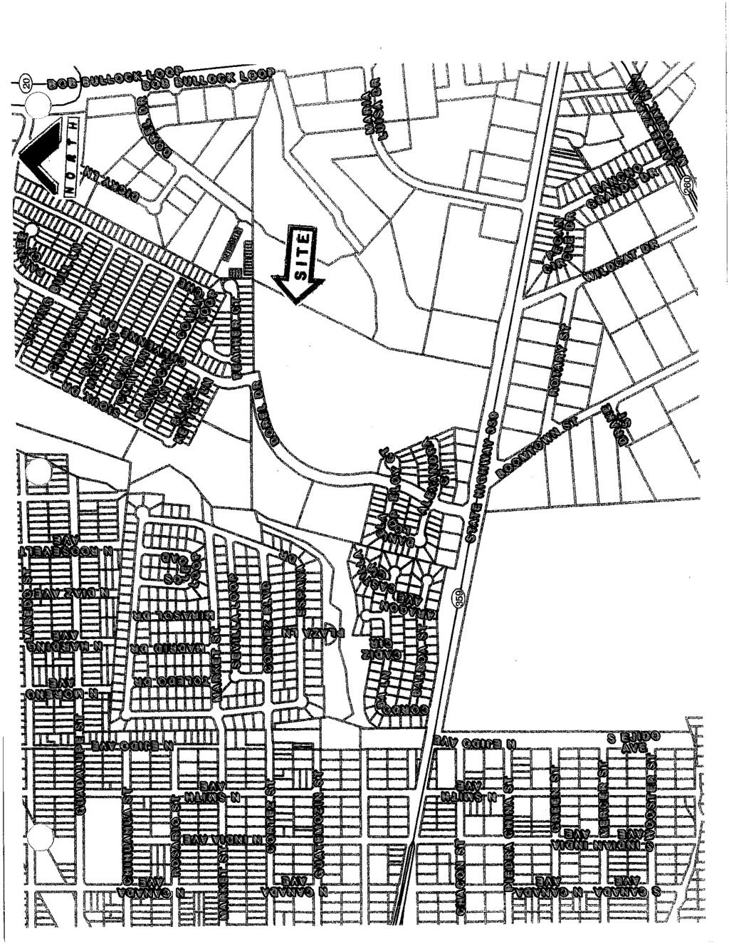
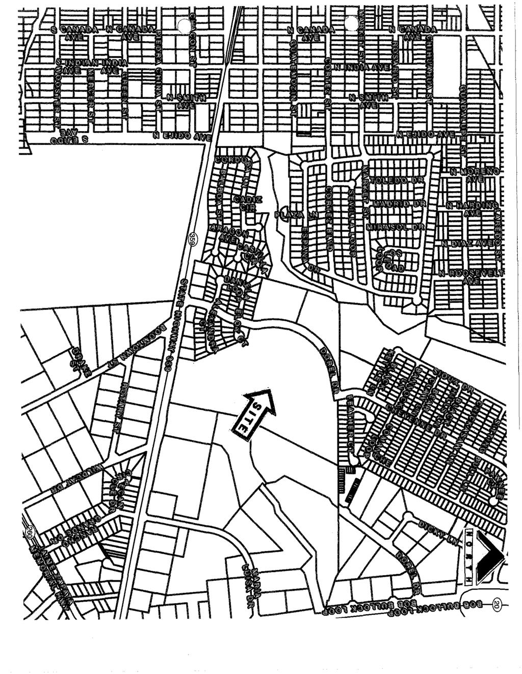
3 V. PUBLC HEARNG AND RECOMMENDATON OF AN ORDNANCE A. Amending the Zoning Ordinance (Map) of the City of Laredo by rezoning Lot la, Block, McPherson Square Subdivision, located at 6102 McPherson Road, from B-3 (Community Business District) to B-4 (Highway Commercial District). District V- Cm. Roque Vela, Jr. B. Amending the Zoning Ordinance (Map) of the City of Laredo by rezoning N 62.4' of Lot 8, W 34.49' of north 62.4' of Lot 7, and E 35' of Lot 7, Block 1693, Eastern Division, located at 2305 N Arkansas Ave., & 2816 Clark Blvd., from B-1 (Limited Commercial District) to B-3 (Community Business District). District V- Cm. Juan Narvaez. C. Amending the Zoning Ordinance (Map) of the City of Laredo by rezoning Lot, Block 414, Eastern Division, located 3820 Cedar Avenue, from R-3 (Mixed Residential District) to R-0 (Residential/Office District). District V - Cm. Juan Narvaez. D. Amending the Zoning Ordinance (Map) of the City of Laredo by rezoning the East half(l/2) of Lot 6, Block 765, Western Division, located at 2820 San Agustin Avenue, from R-3 (Mixed Residential District) to B-1 (Limited Business District). District Vlll - Cm. Roberto Balli. E. Amending the Zoning Ordinance (Map) of the City of Laredo by rezoning the East 42 feet of Lots 7 and 8, Block 265, Western Division, located at 1015 Frankfort Street, from R-3 (Mixed Residential District) to B-1 (Limited Business District). District V- Cm. Roberto Balli. F. Amending the Zoning Ordinance (Map) of the City of Laredo by authorizing a Special Use Permit for Oil and/or Gas Extraction and Production, plug/abandonment of McNary-Ramsey# Well on one acre, located North of Wormser Road and East ofcuatro Vientos Road. District - Cm. Rudy Gonzalez, Jr. G. Amending the Zoning Ordinance (Map) of the City of Laredo by rezoning acres, as further described by metes and bounds in attached Exhibit "A", located South of Dorel Drive and Cheyenne Drive ntersection from R-1 (Single Family Residential District) to B-3 (Community Business District). District - Cm. Vidal Rodriguez. H. Amending the Zoning Ordinance (Map) of the City of Laredo by rezoning Lot -A, Block 1211, Eastern Division, located at 603 N. Malinche Avenue, from R-1 (Single-Family Residential District) to R-2 (Multi-Family Residential District). District -Cm. Alejandro "Alex" Perez, Jr.. Amending the Zoning Ordinance (Map) of the City of Laredo by authorizing a Conditional Use Permit for children's amusement services (indoors) on Lot 3, Block 1, San sidro McPherson No. Subdivision, located at 9902 Crystal Court, Suites 103, 104 and 105. District V- Cm. Charlie San Miguel. V. REVEW AND CONSDERATON OF THE FOLLOWNG MASTER PLANS: A. Moreno Commercial Subdivision Master Plan, located north of State Highway 359 and east of Dorel Drive. District - Cm. Vidal Rodriguez. Page2
4 V. CONSDERATON OF THE FOLLOWNG PRELMNARY PLATS: A. Plat of Moreno Commercial Subdivision Phase!,located north of State Highway 359 and east of Dorel Drive. District - Cm. Vidal Rodriguez. B. The Village Townhomes Plat, located north of Calle Del Norte and west of Springfield Avenue. District V- Cm. George Altgelt. C. Bunn Moreno Commercial Subdivision, located north of State Highway 359 and east of Dorel Drive. District - em. Vidal Rodriguez. D. Lomas Del Sur Subdivision Unit X, located north of Lomas Del Sur Boulevard and east of Ej ido Road. District - Cm. Rudy Gonzalez. X. CONSDERATON OF THE FOLLOWNG FNAL PLATS: A. Plat of Killam- Loop 20 Billboard #!,located west of Bob Bullock Loop and north of Shiloh Drive. District V- em. Charlie San Miguel. B. Plat of San sidro Southeast Commercial Phase, located west of Bob Bullock Loop and north ofhavanna Drive. District V- Cm. Charlie San Miguel. C. Plat ofcuatro Vientos Sur Subdivision Phase V, located north of Exodus Drive and East of Ejido Avenue. District - Cm. Rudy Gonzalez, Jr. X. CONSDERATON OF MODEL SUBDVSON COMPLANCE: A. Plat of Khaledi Garden Homes Subdivision, located north of Gracie Lane and east of Winfield Parkway. District V- Cm. Charlie San Miguel. B. Eleden Subdivision Phase XV,located south of the proposed Soria Drive extension and west of Ejido Avenue. District - Cm. Rudy Gonzalez, Jr. X. ADJOURNMENT THS NOTCE WAS POSTED AT THE MUNCPAL GOVERNMENT OFFCES, 1110 HOUSTON STREET, LAREDO, TEXAS, AT A PLACE CONVENENT AND READLY ACCESSBLE TO THE PUBLC AT ALL TMES. SAD NOTCE WAS POSTED ON FRDAY, JUNE 10,2016 BY 6:00P.M. Director of Planning. H. Ramirez Acting City Secretary Page 3
5 PLANNNG & ZONNG COMMUNCATON Date: SUBJECT: PUBLC HEARNG AND RECOMMENDATON OF AN ORDNANCE Amending the Zoning Ordinance (Map) of the City of Laredo by rezoning Lot la, Block 1, 06/16/2016 McPherson Square Subdivision, located at 6102 McPherson Road, from B-3 (Community Business District) to B-4 (Highway Commercial District). tem V.A DistrictV ZC nitiated by: Staff source: Leopoldo Ruiz, Owner Horacio A. de Leon, Jr., Asst. City Manager Mariscos Kissi Restaurant/Dagoberto Audeves, Applicant Nathan R. Bratton, Planning Director Prior action: None. BACKGROUND Council District: V- The Honorable Roque Vela Proposed use: Restaurant Selling Alcohol Site: Mariscos Kissi Restaurant Surrounding land uses: North of the property are Commercial Plaza (9 suites), Bright Beginnings, Kristi-Lins Academy, and a Commercial Plaza (3 Suites, to include Hollywood Boutique, CS Security, and Litho Business Forms). East of the property across McPherson Road, are First Assembly of God Church, ATT Yard, and a Commercial Plaza (11 Suites, to include Healing Hands, Home Care, Dental Care, N Nationwide, Altitude, M Networks, AM nsurance, con Builders, and Direct Floor Center). South of the property are a Commercial Plaza (7 Suites, to include Gold Nugget, Hair Salon, Gabriel's Taylor Shop, Laredo District People Office, and a Bar), McPherson Oaks Commercial Plaza (12 Suites, to include El Manana and several medical offices) and Plains Capital Bank. West of the property single family residential subdivision that abuts the property. Comprehensive Plan: The Future Land Use Map recognizes this area as Light Commercial. Transportation Plan: The Long Range Thoroughfare Plan identifies McPherson Road as a Major Arterial. The Plan does not identity Del Norte Loop (south of the property). Letters sent to surrounding property owners: 25 n Favor: 0 Opposed: 0 STAFF COMMENTS The proposed zone change is not appropriate at this location. The B-3 zoning is well established, and introducing a B-4 district will negatively affect the area. Staff does not support the proposed zone change for the following reasons: 1. The proposed zone change may introduce more intense uses than those currently existing in the surrounding, well established light commercial area. Uses allowable in a B-4 district are more intense and possible less desirable and include such uses as bar, nightclub, cantina, saloon, amusement redemption machine establishment, amusement services (outdoor), petroleum sales (wholesale), alcoholic beverage storage and distribution, scrap/waste recycle collection, automobile sales-wholesale, auto body repair, recreational vehicle parking lot, auto paint shop, auto muffler shop, major appliances sales (outdoor), mobile home dealer/sales only, truck/heavy equipment driving school, etc. Continued... P&Z COMMSSON RECOMMENDATON: STAFF RECOMMENDATON: The P & Z Commission, in a_to_vote, recommended of the zone change. Staff does not support the proposed zone change, but would consider a Special Use Permit. Page 1 of 2
6 PLANNNG & ZONNG COMMUNCATON STAFF COMMENTS CONTNUED... 2.The proposed zone change is not appropriate at this location, because it is not compatible with the Comprehensive Plan's designation as Light Commercial. 3. The proposed district is not compatible with the existing zoning along the north section of McPherson Road. This is a stable, homogenous light commercial district with no trending toward more intense uses. MPACT ANALYSS B-4 (Highway Commercial District): The purpose of the B-4 District (Highway Commercial District) is to provide for those businesses and services serving a regional area which are to be located primarily along principal (major) arterial streets or the freeway, as classified in the Transportation Plan of the City of Laredo. t is intended for this zoning classification to exist primarily along principal arterial streets or the freeway and to impose site development regulations to ensure adequate access of all uses within this classification. s this change contrary to the established land use pattern? Yes. The proposed property is located south of Commerce Dr. and north of Del Norte Loop which is entirely a light commercial. The property also abuts low density residential uses (Rl Zoning District, west of the property). Would this change create an isolated zoning district unrelated to surrounding districts? No, there are existing B-4 districts south of the property across Del Norte Loop (uses as a bar and maquinitas use), however the predominant uses around the property are light commercial uses and some of them abut a residential district to the west. Will change adversely influence living conditions in the neighborhood? Yes, the area is already a commercial corridor with heavy traffic that could increase noise and traffic in the neighborhood. Are there substantial reasons why the property cannot be used in accordance with existing zoning? Yes. The existing B-3 (Community Business District) even though allows for commercial uses as a restaurant, selling alcohol would require a Special Use Permit for a restaurant selling alcohol for compliance or a B-4 zoning district.. Page 2 of 2
 -> 84 (HGHWAY COMMERCAL")
7 l:2a 6103 L: 1 152'1 f 6010 L:2B 1313 L: UNPLATTED ZONNG MAP 1 inch = 100 feet Date: 5/31/2016 ZC COUNCL DSTRCT MCPHERSON RD REZONE FROM 83 (COMMUNTY BUSNESS DSTRCT) -> 84 (HGHWAY COMMERCAL DSTRCT)

8 DSCLAMER The information provided in this map was submitted to, gathered by and/or developed by the City of Laredo from various sources. Geographic information has a high probability of becoming outdated from the time it is collected and therefore, at-presentground conditions should be assessed to determine the accuracy of provided information. The City of Laredo assumes no liability for any decisions made or actions taken or not taken by the user of this data in reliance upon any data furnished herewith. The use of this data indicates your unconditional acceptance of all risks associated with the use of this data.
9 DSCLAMER The information provided in this map was submitted to, gathered by and/or developed by the City of Laredo from various sources. Geographic information has a high probability of becoming outdated from the time it is collected and therefore, at-presentground oonditions should be assessed to determine the accuracy of provided information. The City of Laredo assumes no i"ability for any decisions made or actions taken or not taken by the user of this data in reliance upon any data furnished herewith. The use of this data indicates your unoondilional acceptance of all risks associated with the usa of this data. rill'"... 5!., '"'C s;: z z G) tj "' l

10 DSCLAMER The information provided in this map was submitted to, gathered by and/or developed by the City of Laredo from various sources. Geographic information has a high probability of becoming outdated from the lime it is collected and therefore, at-presentground cond1lions should be assessed to determine the accuracy of provided information. The City of Laredo assumes no liability for any decisions made or actions taken or not taken by the user of this data in reliance upon any data furnished herewith. The usa of this data indicates your unconditional acceptance of all risks associated with the use of this data.

11 DSCLAMER The information provided in this map was submitted to, gathered by and/or developed by the City of Laredo from various sources. Geographic information has a high probability of becoming outdated from the time it is collected and therefore, at-presenlground a:mditions should be assessed to determine the accuracy of provided information. The City of Laredo assumes no lfabihly for any decisions made or actions taken or not taken by the user of this data in reliance upon any data furnished herewith. The use of this data indicates your unconditional acceptance of all risks associated with the use of this data.
 -> 84 (HGHWAY COMMERCAL")
12 ZONNG OVERVEW 1 inch = 500 feet Date: 5/31/2016 ZC COUNCL DSTRCT MCPHERSON RD REZONE FROM 83 (COMMUNTY BUSNESS DSTRCT) -> 84 (HGHWAY COMMERCAL DSTRCT)
 -> 84 (HGHWAY COMMERCAL")
13 FUTURE LANDUSE MAP ZC inch = 100 feet COUNCL DSTRCT 5 Date: 5/31/ MCPHERSON RD REZONE FROM B3 (COMMUNTY BUSNESS DSTRCT) -> 84 (HGHWAY COMMERCAL DSTRCT)
 -> B4 (HGHWAY COMMERCAL")
14 AERAL MAP 1 inch = 100 feet Date: 5/31/2016 ZC COUNCL DSTRCT MCPHERSON RD REZONE FROM B3 (COMMUNTY BUSNESS DSTRCT) -> B4 (HGHWAY COMMERCAL DSTRCT)
15 '' 1703 'L: 1 ' \ \ \ '- ' L: 1 1 inch = 100 feet Date: 5/31/2016 ZC COUNCL DSTRCT MCPHERSON RD 6019 L: 1 REZONE FROM B3 (COMMUNTY BUSNESS DSTRCT) -> B4 (HGHWAY COMMERCAL DSTRCT)
16 1602 L: L: L: '' 6202 L: L: 'L: L: L: 3 '' L: 2-A 6108 L:4 21 : L:2 \ \ \ \ \ ' ' L: L: L: 1 200' NOTFCATON 1 inch = 100 feet Date: 5/31/2016 ZC COUNCL DSTRCT MCPHERSON RD 6019 L: 1 REZONE FROM 83 (COMMUNTY BUSNESS DSTRCT) -> 84 (HGHWAY COMMERCAL DSTRCT)

17 () ()
 0 c:c N 0 \0... a.")
18 C) () \0..-! <;!" "tj c:::: c 0 "' () 0 c:c N 0 \0... a.. <;!" m u u c:c N N 0..-! \0

19 () "0 a::: c Vl 0 """ co... N Q) 0..c ' c.. """ m u u N co :::!! N 0.- \0
..1:: c.")
20 (} \ \ \ \ \ """ 0 c:l N ' """ m u c:l N '"C 0::: c 0 V... Q)..1:: c.. u N
 N 0.::. 1.0... a.. '<:!\" M u u N co N 0.")
21 () n "'C c:::: c '<:!" ) 0 co... Q) N 0.:: a.. '<:!" M u u N co N
22 () "'C c:: c ) 0... al "'" (]) N 0..r::: a.. "'" ("(') u u al N N
 u u 1:0 N N 0.-t 1.0")
23 (} n "'C a::: c: t <:t 0 1:0 N V... QJ 0..c: c.. <:t ("() u u 1:0 N N 0.-t 1.0

24 () /. ': ' ' /' ', l ';. ' \ \

25 "'C c::: c: t <::!" V 0 cc... Q) N 0..c: c.. '<::!" C'l'l u u N cc N
 1:0 N \"C c:: c 0 V... Q).!:: c.. u N 0.")
26 (.) (.\ \ ) """ 1:0 N ' u """ ("(') 1:0 N "C c:: c 0 V... Q).!:: c.. u N
 u c.. ;:: \"' ::;E u ro N 0.")
27 () () "'C 0::: "' s::: ::;;:: 0 0 "'..s::: Q) u c.. ;:: "' ::;E u ro N 0.-t 1.0

28 (j () "0 0::: c "'" V 0 cc... N OJ 0.r: c.. "'" M u u cc N N

29 () "'0 c::: c Vl 0 cc... """ N CJ 0..r::: ' a... """ ("(') u u N cc N
30 PLANNNG & ZONNG COMMUNCATON Date: 06/16/2016 tem V.B SUBJECT: PUBLC HEARNG AND RECOMMENDATON OF AN ORDNANCE Amending the Zoning Ordinance (Map) of the City of Laredo by rezoning N 62.4' of Lot 8, W 34.49' of north 62.4' of Lot 7, and E 35' of Lot 7, Block 1693, Eastern Division, located at 2305 N Arkansas Ave., and 2816 Clark Blvd., from B-1 (Limited Commercial District) to B-3 (Community Business District). District V nitiated by: Eusebio L. Barrios, Owner/ Applicant Prior action: None BACKGROUND Council District: V- The Honorable Juan Narvaez Proposed use: pawn shop Site: Ambulance Service building (current use is a single family residence). ZC Staff source:. Horacio De Leon, Asst. City Manager Nathan R. Bratton, Planning Director Surrounding land uses: Abutting the property to the north are one single family residence and one multifamily complex, to the east there is one vacant lot, and to the south there is one single family residence. North of the property across E O'kane Street are Crown Chiropractic, two multifamily complexes and several single family residences. East of the property are two multifamily complexes, more single family residences and a Day Care. South of the property across Clark Blvd., are Luis Hi Tech Auto Service and Moreno's Meat Market. West to the property are more single family residences and a Day Care. Comprehensive Plan: The Future Land Use Map recognizes this area as Light Commercial and High Density Residential. Transportation Plan: The Long Range Thoroughfare Plan identifies N Arkansas Ave., as a Minor Arterial, and E Clark Blvd. as a Modified Major Arterial, south of the property. Letters sent to surrounding property owners: 24 n Favor: 0 Opposed: 0 STAFF COMMENTS The proposed zone change is not appropriate at this location. The B-1 zoning is well established, and introducing a B-3 district will negatively affect the area. Staff does not support the proposed zone change for the following reasons: The proposed zone change may introduce more intense uses than those currently existing in the surrounding, well established light commercial area. Uses allowable in a B-3 district are more intense and possible less desirable and include such uses as hotel/motel, funeral home, building material sales, auto dealer new/used, upholstery shop, restaurant (drive thru), heavy Continued P&Z COMMSSON RECOMMENDATON: The P & Z Commission, in a _to _vote, recommended ofthe zone change. Page 1 of2 STAFF RECOMMENDATON: Staff does not support the proposed zone change.
31 PLANNNG & ZONNG COMMUNCATON machinery sales/display (inside), pawn shop, portable buildings leasing/storage, portable chemical toilet leasing/storage, commercial parking lot, auto tire repair, tire sales (indoors), auto glass repair/tinting, car wash (self-service), commercial car wash (detail shop), quick lube/oil change, bakery-wholesale, contractor's office/sales, parking areas for vehicles/trailers/rv's, amusement services (indoors), children's amusement services (outdoors), billiard parlor, etc. Staff does not supports the request for the following reasons: 1. The proposed zone change is not compatible with the Comprehensive Plan's designation as Light Commercial. 2. The proposed district is not compatible with the existing zones and uses along this section of Arkansas Ave. This area is following a trend of primarily light commercial. The property meets the location criteria for a B-3 district (to be located along minor or principal arterials); however part of the property (Lot 8) that fronts Arkansas Ave, is already a heavy traffic congested area, and the part of the property (Lot 7) that fronts E Clark Blvd., has a restricted minimal access to it, and does not comply with Section DMENSONAL STANDARDS, Section ; minimum lot width of 46 feet, for a B3 Zoning. The proposed location is too close to a heavy traffic intersection (N Arkansas Ave., and E Clark Blvd.) MPACT ANALYSS B-3 (Highway Commercial District): The purpose of the B-3 District (Community Business District) is to provide for those businesses and services serving a trade area larger than a neighborhood, but smaller than the entire city and located primarily along minor or principal arterial streets, as classified in the Transportation Plan of the City oflaredo.lt is intended for this zoning classification to exist primarily abutting minor or principal arterial streets while preserving established residential neighborhoods along such streets. s this change contrary to the established land use pattern? Yes, the established land use pattern is both light commercial and high density residential in nature. Would this change create an isolated zoning district unrelated to surrounding districts? Yes, there is not an existing B-3 district in the immediate area. The closest B3 district is a block away north of the property; north and south of E Reynolds St. Will change adversely influence living conditions in the neighborhood? Yes, a B-3 district may introduce more intense uses to the neighborhood, (building materials sales, auto dealer new and used, upholstery shop, restaurant-drive thru, heavy machinery sales, pawn shop, pet shop, portable building leasing/storage, portable chemical toilet leasing/storage, commercial parking lot, auto tire repair, tire sales, auto glass repair, commercial car wash, bakery, contractor's office/sales, Billiard, amusement services indoors, etc. Are there substantial reasons why the property cannot be used in accord with existing zoning? No, the existing B-1 (Limited Commercial District) zone allows for sufficient commercial uses. Page 2 of2

32 2620 L: l: L: L:4 &5....; "' ll "' :> c z :! = :: 0.. z 2702 L:B 2701 L: L: L: L: L: L: L:2 L:3A L:4A L:4B ;::;11<::< "''" :" , ' 2304" ' t>5<" L:7 L: L:2 L: L: 8 & 7 E O"KANE ST 55.15& J " ",;;<,2014!-0-08< 'i.72o"- 5 ' ', '""'" J :g.. f :> «!. «olo i 2301 L: 8-7 > iii :-CA RNBitV :D!0' ! ll '' z L: 1 & L:3 M M 2819 L:4....; "' ll "' : L: L:7 L:6 L:5 ZONNG MAP 1 inch = 100 feet Date: 6/2/2016 ZC COUNCL DSTRCT N ARKANSAS AVE REZONE FROM 81 (LMTED COMMERCAL DSTRCT) -> 83 (COMMUNTY BUSNESS DSTRCT) gs.u.p. (SPECAL USE PERMTS) Jc U P. (CONDTONAL USE PERMTS) Os.U.P. & C.U.P.

33 DSCLAMER The infonnation provided in this map was submitted to, gathered by andfor developed by the City of Laredo from various sources. Geographic information has a high probability of becoming outdated from the time it is collected and therefore, at-presentground conditions should be assessed to detennine the accuracy of provided infonnation The City of Laredo assumes no liability for any decisions made or actions taken or not taken by the user of this data in reliance upon any data furnished herewith. The use of this data indicates your unconditional acceptance of all risks associated with the use of this data.

34 DSCLAMER The information provided in this map was submitted to, gathered by andfor developed by the City of Laredo from various sources. Geographic information has a high probability of becoming outdated from the lime it is collected and therefore, at presentground oonditions should be assessed to determine the accuracy of provided information. The City of Laredo assumes no liability for any decisions made or actions taken or not taken by the user of this data in reliance upon any data furnished herewith. The use of this data indicates your unconditional acceptance of all risks associated with the use of this data.

35 DSCLAMER The infonnation provided in this map was submitted to, gathered by and/or developed by the City of Laredo from various sources. Geographic information has a high probability of becoming outdated from the time it is collected and therefore, at-presentground oondions should be assessed to determine the accuracy of provided information. The City of Laredo assumes no liability for any decisions made or actions taken or not taken by the user of this data in reliance upon any data furnished herewith. The use of this data indicates your unconditional acceptance of all risks associated with the use of this data : 1654 L: r-76.5 $ io 0> "' _...;_,_ l : 1693 L:7
 -> 83 (COMMUNTY BUSNESS")
36 ',-----J ZONNG OVERVEW 1 inch = 500 feet Date: 6/2/2016 ZC COUNCL DSTRCT N ARKANSAS AVE REZONE FROM 81 (LMTED COMMERCAL DSTRCT) -> 83 (COMMUNTY BUSNESS DSTRCT)
 -> 83 (COMMUNTY BUSNESS")
37 262e c;$ Low 2,716 l:6 EO'KANE ST 2i:r;9 U us ;co,; "' ll "' :> c z.. :! Ei 0.. z Density 2JQ2 Lew Density ':Vl05 L;,z 204 L:,7 2i71rs L,;A 2718 L;6 z Low Density 2il01 L 1?715 c:,,2 261:9 L4& FUTURE LANDUSE MAP ZC inch = 100 feet COUNCL DSTRCT 4 Date: 6/2/ N ARKANSAS AVE REZONE FROM 81 (LMTED COMMERCAL DSTRCT) -> 83 (COMMUNTY BUSNESS DSTRCT)
 -> B3 (COMMUNTY BUSNESS")
38 AERAL MAP 1 inch = 1 00 feet Date: 6/2/2016 ZC COUNCL DSTRCT N ARKANSAS AVE REZONE FROM B1 (LMTED COMMERCAL DSTRCT) -> B3 (COMMUNTY BUSNESS DSTRCT)
39 L:5 L:8 J;y. ' -' ff.. "' 2619,; 2701 L:4 L: 1 ll "' :> cc cc z :! z 2702 L:5 L:8 \ tf ' NOTFCATON 1 inch = 100 feet Date: 5/31/ L: 1.., r L:7 - L:5 ' c: -- E O'JU(NE ST 55.56'.,'?5f L:2 L: 3A L:4A L:48 ' L: 5 L:6 \ 1.7 \ \ \ 2717 L:3 \ ' ' L:2 i L: ZC COUNCL DSTRCT N ARKANSAS AVE g..,; "' ll "' :> cc :c -z cc :.= : cc z.. ql)w P-t 1:\D l \ \ r L: 6 & L: 12 L: L:9 L:8 L: 8 & r ([_ --, :J=7 lvt::; Jb /". \... ' e;-.0 - ' ' c:r - 'Z f, 'b 2803 \ L: 2'.& 3 \ \ L: 1 L: r, i. cl -- u,.,. k:!. t..., "! ,-"_l. ', M l:ll! i 2816 i / 2301 L:7 L:6 L: 5 CC.,,-7 1:>= "'f::7' - > v L: 8A ll ; z ' l?j:. E CLARK BLVD 90', z ; ; , Wt tf' --- -, t-.. rzh./ h ( L: 1 & 2 L:3 L:4 M L: REZONE FROM B1 (LMTED COMMERCAL DSTRCT) -> 2319 L: 1 '\ \ \ \ "" M - L: L 2300 " ' 5 L: 6A tf l,./, k7. llr 2904 L: L: '4?: '"\ 1-'Yi -T"l;' L:2 L:3 L:4 L:5 lrn n-ee / ) \C "'\ )
40 11ooo L:5 L:8.. "' 2619.; 2701 L:4 "' L: 1 ll :> c z :!i.. s z 2702 L:5 L: L:4& ' NOTFCATON 1 inch = 100 feet Date: 6/2/ L: L:7 L:6 L: 5,, L:2 L: 3A L: 4A L: L:6 \ 2715 L: E q.:j(ane ST 55.56' ; \ z ' c ' X ' c ' '... z L: ZC COUNCL DSTRCT N ARKANSAS AVE 2719 L: L:5...; "' c.. c 2720 L:5 ll "' :> 2719 L: L:8 & 7 L:7 L:6 L: 6 & L: ' ' ' ' ' 2803 L: 2 & L: 1 L:4. 1 'l. / / ;:J. L/8-7' L: L: 12 L: 11 \ \ \ L:6A. '. / l./ 1:1:.. 1.; '2816-' "' L:6 L: 'i.-:-' L: 8A L: 8-7 X, 0 > E CLARK BLVD 90' L: 1 & ;,, ll, ; z L:3 L:4 L: 1 L: L: REZONE FROM 81 (LMTED COMMERCAL DSTRCT) -> 83 (COMMUNTY BUSNESS DSTRCT) L: 10 L:9 L:S 2319 L: 1 "'' L L: L: 2904 L: L: 7 L: 7A 9 8 l> \ ) ' L:3 L:4 L:5 L: 1801 "' 100 Fet 2906 oa.a on<o?qo c.. \ _)
41 2620 L: L: L: L:4 &5 :,; ll "' :> c z ::! = ::t.. 0 z ZONNG MAP 1 inch = 1 00 feel Date: 6/2/ L: L: L: L: L: 8 M 11uoo L:7 L: L:2 L:3A L:7 L: L: 2 L: L:7 L:6 ZC COUNCL DSTRCT N ARKANSAS AVE 2720 L: L: L:8& L: 7 L: 6 L: 6 & 5 L: 5 E O'KANE ST 55.S6'------J L: 4A L: 48 L: 1 L:2& 3 L:4 L < " : id 1--""'"'-.i:fg-:ir-'tl""""':...:.j/. / '-2obo'-030s : L: L:12 L:11 L:10 L:9 L: L'i L 6 ::i L8-7 K L L: L: L: 7A L:8 L:7 > E C:JtRKB:VD 90''-----! C z t z 2805 L: 1 & L:3!;) L:4 L L:5 L: 8 L: L: L:1 L:2 L:3 L:4 L:5 L: L: 13 REZONE FROM B1 (LMTED COMMERCAL DSTRCT) -> B3 (COMMUNTY BUSNESS DSTRCT) 1801 J L: 11-1F-e.-!lllt= cd F ee T gs.u.p. (SPECAL USE PERMTS) C.U.P. (CONDTONAL USE PERMTS) ns.u.p. &C.U.P.
 co V C1J V c C1J..:.:... <( z Ll'l 0 ('(') N")
42 () () "0 > cc..:.:... C1J u \.0... \ m N 0 cc "'"":- N 0 0'1... u """ """ N Q) co V C1J V c C1J..:.:... <( z Ll'l 0 ('(') N

43 () "U > co... 'Cl u 1.0.-t t m N 0 co "'"":- N 0 CT... """.-t u N Q) co ll 'Cl ll c: 'Cl... <( z m N
44 () (} "0 > 1:0...loO: "- t'1l u t t!"(') N 0 1:0 """":- N QJ 0 en +-' """.-t u c:c <n t'1l N <n c t'1l...loo: "- <( z 1.{') 0!"(') N
45 () () "'C > 1:0... ctl u \0.- \ m N 0 1:0 ""':- N 0 en +"' o::t.- u N QJ 1:0 ll ctl ll c ctl... <( z Ll'l 0 m N
 N 0 co ':- N 0 0\"1... <:!\"... co u N OJ Ji Vl ro Vl c ro.")
46 ( ) "0..2: co... ro u ('(') N 0 co ':- N 0 0"1... <:!"... co u N OJ Ji Vl ro Vl c ro... <( z ) 0 ('(') N
 N 0 co '\"'-:- N 0 0\"1... u \"\"\" N.")
47 () () "'C..2: co... l'tl u ("() N 0 co '"'-:- N 0 0"1... u """ N... co Q) Vl l'tl Vl c: l'tl... <( z ll 0 ("() N
48 () () "'C > :C... rc u ! ! ("(') N 0 :C "":- N 0 0"1 +-' """..-! u :C N QJ V rc V c rc... <( z Ll'l 0 ("(') N
49 () () "0 cc... C1l u rtl N 0 c::l "'":- N 0 0"1... """ u.- c::l N Q) V C1l V c: C1l... <( z.{') 0 ("() N
50 () () "'C.2: al,_ ro u ("(') N 0 al ':- N Q) 0 > C'l +-' <(.- V u """ al ro N V s::,_ ro <( 2 Lfl 0 ("(') N
51 PLANNNG & ZONNG COMMUNCATON Date: SUBJECT: PUBLC HEARNG AND RECOMMENDATON OF AN ORDNANCE 06/16/16 Amending the Zoning Ordinance (Map) of the City of Laredo by rezoning Lot 11, Block 414, Eastern Division, located 3820 Cedar Avenue, from R-3 (Mixed Residential District) tem to R-0 (Residential/Office District). V. C. ZC nitiated by: Staff source: Juan M. Gonzalez, applicant Horacio De Leon, Assistant City Manager AuroraS. Gonzalez, owner Nathan R. Bratton, Planning Director Prior action: None. BACKGROUND Council District: V- The Honorable Juan Narvaez Proposed use: Office Site: Office Surrounding land uses: The properties to the north include single-family residential uses, vacant lots and glesia Unidos en Cristo. West of the site are multi-family residential uses, single-family residential uses and manufactured homes. To the South are Cake Land, a Nursery, Gram Jewlers, Zapata Auto Center and Ramos Auto Sales. To the East are multi-family residential uses and singlefamily residential uses. Comprehensive Plan: The Future Land Use Map recognizes this area as High Density Residential. Transportation Plan: The Long Range Thoroughfare Plan does not identify Cedar Avenue or Olive Street. Letters sent to surroundin2 property owners: 28 lnfavor: 0 Opposed: 0 STAFF COMMENTS Staff supports the request of the proposed R-0 district at this location for the following reasons: 1. The proposed district is compatible with the existing zones and uses in the area. 2. Uses allowable in an R-0 district include multi-family residential, medical and dental clinics, restaurants, bed & breakfast, dance & music schools, pharmacies and bookstores. P&Z COMMSSON RECOMMENDATON: The P & Z Commission, in a to vote, recommended of the zone change. STAFF RECOMMENDATON: Staff supports the proposed zone change. Page 1 of 2
52 PLANNNG & ZONNG COMMUNCATON MPACT ANALYSS R-0 (Residential Office District): The purpose of the R-0 District is to allow a mix of residential and limited businesses and which would restrict the residential to not more than three dwellings on one site, and the businesses to office uses, and very limited commercial. s this change contrary to the established land use pattern? Yes, the established land use pattern along Olive Street and Cedar Avenue is primarily mixed residential in nature. However, the properties adjacent to the South front Sauoders Avenue and are primarily commercial in nature. Would this change create an isolated zoning district unrelated to surrounding districts? No, the adjacent property is zoned B-3. Will change adversely influence living conditions in the neighborhood? No, the property is already adjacent to similar uses. Are there substantial reasons why the property can not be used in accord with existing zoning? Yes, the existing zoning only permits residential uses. Page 2 of 2

53 L:8 L:9 L: L: L: 12 L:2 L:4 L:6 l:8 L: 10 L: L: L:4 L:8 L: 10 z oc... 0 " 802 L:2 601 L: L:3 E SAUNDERS ST ss 603 l:5 607 L: L:9 l:11.. ll ll = Cl ll u 701 l: L: 3 E SAUNDERS ST 65' 705 L: L: 7 L L: ZONNG MAP 1 inch = 100 feet Date: 5/31/2016 ZC COUNCL DSTRCT CEDAR AVE (619 OLVE) REZONE FROM R3 (MXED RESDENTAL DSTRCT) -> RO (RESDENTAL/ OFFCE DSTRCT)
 REZONE FROM R3 (MXED RESDENTAL DSTRCT) -> RO (RESDENTAL OFFCE")
54 . AERAL MAP 1 inch = 100 feet Date: 5/31/2016 ZC COUNCL DSTRCT CEDAR AVE (619 OLVE) REZONE FROM R3 (MXED RESDENTAL DSTRCT) -> RO (RESDENTAL OFFCE DSTRCT)
 REZONE FROM R3 (MXED RESDENTAL DSTRCT) -> RO (RESDENTAL OFFCE")
55 ZONNG OVERVEW ZC inch = 500 feet COUNCL DSTRCT 4 Date: 5/31/ CEDAR AVE (619 OLVE) REZONE FROM R3 (MXED RESDENTAL DSTRCT) -> RO (RESDENTAL OFFCE DSTRCT)
 REZONE FROM R3 (MXED RESDENTAL DSTRCT) -> RO (RESDENTAL OFFCE")
56 1 inch = 100 feet Date: 5/31/2016 ZC COUNCL DSTRCT CEDAR AVE (619 OLVE) REZONE FROM R3 (MXED RESDENTAL DSTRCT) -> RO (RESDENTAL OFFCE DSTRCT)
57 3820 Cedar Avenue R-3 (Mixed Residential District) to R-0 (Residential/Office District) ZC
.;:t Pt'\" <(; '9f :>F 5(\" sf l.tp\ 1 oc, i)j,.")
58 L: 1, 1 Mt1 v.-e r...:;.;r 3912 L:5 L:4 L: L: 1 L \fjj.. l),:j), ' ' L:4 L:3 t.. i\.l llj.,; 4151 f L: 3 \(A_C L:11 L:12 CR ' NOTFCATON 1 inch= 100 feet Date: 5/31/ L: 2 & 1 -s;;.. : 3808 L: 2 & 1 '\ht L:2 t: lp;.).;:t Pt'" <(; '9f :>F 5(" sf l.tp\ 1 oc, i)j,.a L: 18 L: 2A L: 28 L: 3A L: 38 l e- f F:._39o;;;o...L...::...-+.:...::---..L-..;;39""'16,--L--' L:4A L:48 Ljl. :3 L:5 602 * 601 L: 1 ZC COUNCL DSTRCT CEDAR AVE (619 OLVE)... 1S \;. ;.;o.q) L:6A L:68 sf j L:5A '!:A 617. f19 L: 9 L:i1. / o u L:9 G L:9 -.\A ;;:;;c- cr. _r.;'1:;;1-l:::::!= L:28 >. -r L 4A rs? 706 L:48 ff ' \\ ;;.8 ' rs :: 3820 L: 9 &1..r- l..r! (;,f. 11/Ff- Sf L: 1... S,. ---.: L:3 L:5 L:5 L: 7 13j ri 'f'j -:7P 702 u; fa L:2 L:4 7i8 L:8 L:10 <!.: 6 ;# ' E SAil'NDERS ST 53', ; E SAUNDERS ST 65' (S Sf L:3 L: 5 L:7 1 " '*"'ONE FROM R3 (MXED RESDENTAL DSTRCT) -> RO (RESDENTAL OFFCE DSTRCT) L: :1;, " 3913 L: 1 & 3& L: 1 & 3& L: 2 & 4&6 c:: 3901.,..;,::;:; L: 4A < 3817 L: 1 & 3 \
59 3820 Cedar Avenue R-3 (Mixed Residential District) to R-0 (Residential/Office District) ZC
60 3820 Cedar Avenue R-3 (Mixed Residential District) to R-0 (Residential/Office District) ZC
61 PLANNNG & ZONNG COMMUNCATON Date: SUBJECT: PUBLC HEARNG AND RECOMMENDATON OF AN ORDNANCE 6/16/16 Amending the Zoning Ordinance (Map) of the City of Laredo by rezoning the East half (112) of Lot 6, Block 765, Western Division, located at 2820 San Agustin Avenue, from R-3 tem (Mixed Residential District) to B-1 (Limited Business District). ZC V.D. nitiated by: Ricardo Roberto Gonzalez, owner Prior action: None BACKGROUND Council District: V - The Honorable Roberto Balli Proposed use: Flower Shop Site: Vacant residential structure Staff source: Horacio De Leon, Asst. City Manager Nathan R. Bratton, Planning Director Surrounding land uses: North of the site are single-family residential uses and multi-family residential uses. To the West are single-family residential uses, a warehouse, a vacant commercial structure and vacant lots. To the East of the property are single-family residential uses, Lefleur Transportation, Jesus Flores Sewing Machine Co., a law office, mports Pancho Villa, offices, and Cuevas Metal Art. To the south are single-family residential uses, multi-family residential uses. Comprehensive Plan: The Future Land Use Map recognizes this area as High Density Residential. Transportation Plan: The Long Range Thoroughfare Plan does not identify Frankfort Street or San Agustin Avenue. Letters sent to surrounding property owners: 37 nfavor: 0 Opposed: 0 STAFF COMMENTS Staff does not support the request for the following reasons: 1. The proposed district is not consistent with the Comprehensive Plan's designation for this area as High Density Residential. 2. This area along Frankfort Street and San Agustin Avenue is following a primarily residential pattern of development. 3. The property is of a small size to accommodate commercial uses permitted in a B-1 district. P&Z COMMSSON RECOMMENDATON: The P & Z Commission, in a to vote, recommended of the zone change. STAFF RECOMMENDATON: Staff does not support the proposed zone change. Page 1 of2
62 PLANNNG & ZONNG COMMUNCATON MPACT ANALYSS B-1 (Limited Business District): The purpose of the B-1 District is to provide for business and commercial development serving to a limited geographic area or neighborhood. s this change contrary to the established land use pattern? Yes, the established land use pattern is mixed residential in nature. Would this change create an isolated zoning district unrelated to surrounding districts? The properties to the west of San Augusin Avenue are zoned R-3, however the properties to the east are zoned B-1. Will change adversely influence living conditions in the neighborhood? Yes, the proposed district may introduce more intense uses into the neighborhood. Are there substantial reasons why the property cannot be used in accord with existing zoning? Yes, the current district only allows for residential uses. Page2 of2

63 jg ll :> c.. ll ll g... FRANKFORT ST 55.56', l = f i: z.. ;;;: 6 '!C z ;c 2907 L: L: L: L: L: L: L: L: L: L:4.... ll 2908 :> L:3 c 0 Q ll c 2906 z L:2 ll ll ll z 2902 L: L: L:5.. c in M.. ll :> 2810 c L'4 0 Q ll c z ll ll ll z c.. ZONNG MAP 1 inch = 75 feet Date: 5/31/2016 ZC COUNCL DSTRCT SAN AGUSTN AVE -' ' 2801 L: 12 REZONE FROM R3 (MXED RESDENTAL DSTRCT) -> B1 (LMTED COMMERCAL DSTRCT)
 > 81 (LMTED COMMERCAL")
64 AERAL MAP 1 inch = 75 feet Date: 5/31/2016 ZC COUNCL DSTRCT SAN AGUSTN AVE REZONE FROM R3 (MXED RESDENTAL DSTRCT) > 81 (LMTED COMMERCAL DSTRCT)
( U ZONNG OVERVEW 1 inch = 400 feet Date: 5/31/2016 ZC-45-2016 COUNCL DSTRCT 8 2820 SAN")
65 0 z :,. :, i )( U ZONNG OVERVEW 1 inch = 400 feet Date: 5/31/2016 ZC COUNCL DSTRCT SAN AGUSTN AVE REZONE FROM R3 (MXED RESDENTAL DSTRCT) -> B1 (LMTED COMMERCAL DSTRCT)
![....,;.. ll ;3 ll g... FRANKFORT ST 55.56' ]g lu z ;:.. : z oc.](/docs-images/74/71000950/images/66-0.jpg ". oc \" FUTURE LANDUSE MAP ZC-45-2016 1 inch = 75 feet COUNCL DSTRCT 8 Date: 5/31/2016 2820 SAN AGUSTN AVE REZONE FROM")
66 ....,;.. ll ;3 ll g... FRANKFORT ST 55.56' ]g lu z ;:.. : z oc.. oc " FUTURE LANDUSE MAP ZC inch = 75 feet COUNCL DSTRCT 8 Date: 5/31/ SAN AGUSTN AVE REZONE FROM R3 (MXED RESDENTAL DSTRCT) -> 81 (LMTED COMMERCAL DSTRCT)
67 2820 San Agustin Avenue R-3 (Mixed Residential District) to B-1 (Limited Business District) ZC
 to B-1 (Limited Business District)")
68 2820 San Agustin Avenue R-3 (Mixed Residential District) to B-1 (Limited Business District) ZC
69 2820 San Agustin Avenue 1 R-3 (Mixed Residential District) to B-1 (Limited Business District) ZC
70 :::J c.o 2908 L4 toy L:3 2904,.. e L: 2 -;::::;r L:16F 2820 L6?F 2814 L: L: L: L: L: 1 tjr sf tf r {AG U::'.' - L:4 cc 1----'-"C_. T--ll 1;e ' ,.&._.J 291 0,' Ltr L: L>'l<l -:5-291!2 L2t?'f L: 12 L: 1,. -r.,'......::<s...::f,_.:..m...!."-'-f_'----'------;, L: 7 L: 7 FRANKFORT ST 55.56' 1009 L:6 5F L:8 L: \ e)o-e_. L 5 Sf :, ,.. 2-BF.. "' ii 21)07.. ll g... ' \ ;,.g J 765 J 2810 L: 4 & $F 3 \\ 2805 \ L: :::_ ;::"' L:3 vf" 'VA C SrH :12 280:r;: L: 2_.-$"" = ll ::>.. u c z.. c c z ;:: WJ L:1 'Sf 2903 '' L 11 \ J Co' ' ' L: L: 1 Sf' ; 2810 L: 4 OffiL-<? ti 2L /' _L <-'.1 i_.s 2804 Mdr... ll ::> c 0 Q c z ll ll z c.. l!! ll ::> c 0 Q c z ll ll.. z c \ \... \. / r 200' NOTFCATON 1 inch = 75 feet Date: 5/31/2016 ZC COUNCL DSTRCT SAN AGUSTN AVE REZONE FROM R3 (MXED RESDENTAL DSTRCT) > B1 (LMTED COMMERCAL DSTRCT)
71 PLANNNG & ZONNG COMMUNCATON Date: SUBJECT: PUBLC HEARNG AND RECOMMENDATON OF AN ORDNANCE 6/16/16 Amending the Zoning Ordinance (Map) of the City of Laredo by rezoning the East 42 feet of Lots 7 and 8, Block 265, Western Division, located at 1015 Frankfort Street, from R-3 tem (Mixed Residential District) to B-1 (Limited Business District). ZC V. E. nitiated by: Silvia Amaro, owner Prior action: None BACKGROUND Council District: V- The Honorable Roberto Balli Proposed use: Storage Site: Vacant warehouse Staff source: Horacio De Leon, Asst. City Manager Nathan R. Bratton, Planning Director Surrounding land uses: North of the site are single-family residential uses and multi-family residential uses. To the West are single-family residential uses, a warehouse, a vacant commercial structure and vacant lots. To the East of the property are single-family residential uses, Lefleur Transportation, Jesus Flores Sewing Machine Co., a law office, mports Pancho Villa, offices, and Cuevas Metal Art. To the south are single-family residential uses and multi-family residential uses. Comprehensive Plan: The Future Land Use Map recognizes this area as High Density Residential. Transportation Plan: The Long Range Thoroughfare Plan does not identify Frankfort Street. Letters sent to surrounding property owners: 33 nfavor: 0 Opposed: 0 STAFF COMMENTS Staff does not support the request for the following reasons: 1. The proposed district is not consistent with the Comprehensive Plan's desigoation for this area as High Density Residential. 2. This area is following a primarily residential pattern of development. 3. The proposed district may introduce more intense and incompatible uses to the surrounding residential neighborhood. P&Z COMMSSON RECOMMENDATON: The P & Z Commission, in a to vote, recommended of the zone change. STAFF RECOMMENDATON: Staff does not support the proposed zone change. Page 1 of2
72 PLANNNG & ZONNG COMMUNCATON MPACT ANALYSS B-1 (Limited Business District): The purpose of the B-1 District is to provide for business and commercial development serving to a limited geographic area or neighborhood. s this change contrary to the established land use pattern? The established land use pattern is primarily residential in nature. Would this change create an isolated zoning district unrelated to surrounding districts? Yes, this area is predominantly zoned R-3. Will change adversely influence living conditions in the neighborhood? Yes, the proposed district may introduce more intense uses into the neighborhood. Are there substantial reasons why the property cannot be used in accord with existing zoning? Yes, the current district only allows for residential uses. Page2 of2

73 ';o "',; ll ll :> c.. ll : FRANKFORT ST 55.56' ' '.. ll "' : > 1 z iii: ; ll c :i «... ' 2907 L: L: L: L: L: L: L: L: L: L: L: L: L: L: l: L: L:4 ALAMO ST 55,56' ZONNG MAP 1 inch = 75 feet Date: 5/31/2016 ZC COUNCL DSTRCT FRANKFORT ST REZONE FROM R3 (MXED RESDENTAL DSTRCT) -> 81 (LMTED COMMERCAL DSTRCT)
 -> 81 (LMTED COMMERCAL")
74 AERAL MAP 1 inch ; 75 feet Date: 5/31/2016 ZC COUNCL DSTRCT FRANKFORT ST REZONE FROM R3 (MXED RESDENTAL DSTRCT) -> 81 (LMTED COMMERCAL DSTRCT)

75 0 % ",. J:, - X )( U o... ZONNG OVERVEW 1 inch = 400 feet Date: 5/31/2016 ZC COUNCL DSTRCT FRANKFORT ST REZONE FROM R3 (MXED RESDENTAL DSTRCT) > 81 (LMTED COMMERCAL DSTRCT)

76 ,95'55!11\Y N.LSnOY NYS.... id.;... 0 ::E... c c,95'55!11\y
77 1015 Frankfort Street R-3 (Mixed Residential District) to B-1 (Limited Business District) ZC
78 1015 Frankfort Street R-3 (Mixed Residential District) to B-1 (Limited Business District) ZC
79 1015 Frankfort Street R-3 (Mixed Residential District) to B-1 (Limited Business District) ZC
80 2915 L: L: L: L: L: L:2 ; ; ; ; L: no L: L: L: '"... L: L: ' ' 2907 L: L: L: 11 ns L 2901 L: L: L: L: L: 1 2A T 2,08 Lj4 lt l764-j---7\ L: L:3 \ \ 1120 L: L: 12 \ 2804 ' L: 2 ' 2802 L: 1 ' ' ' ' ll.; ll ll :> c ;;! a: L: L: L: 12 FRANKFORT ST 55.56' / '_/jets-- / Y? L: L: L: </ L L: L:9 '.-1(b5 t: s L: L:4 28f0 L:4& l{ 765l '----F-::=:---l... ; L: L: L: L: L: ; L: 1, --_ L ALAMO ST 55.56' ; ll.; "' ll ll :> c z ;:... :J " c z ; ;, \ \ \ \ L: L: L: L: L: L: L: 12 ' ' ',r L 28 L: 28 L: 281 L: 2801 L: 280 L: 280 L: 1 200' NOTFCATON 1 inch = 75 feet Date: 5/31/2016 ZC COUNCL DSTRCT FRANKFORT ST REZONE FROM R3 (MXED RESDENTAL DSTRCT) > 81 (LMTED COMMERCAL DSTRCT)
81 PLANNNG AND ZONNG COMMUNCATON Date: SUBJECT: PUBLC HEARNG AND RECOMMENDATON OF AN ORDNANCE 6/16116 Amending the Zoning Ordinance (Map) of the City of Laredo by authorizing a Special Use Permit for Oil and/or Gas Extraction and Production, plug/abandonment of McNary-Ramsey tem #1 Well on one acre, located North of Wormser Road and East ofcuatro Vientos Road. V.F. ZC nitiated by: Staff source: Columbus Energy, applicant Horacio De Leon, Asst. City Manager 4V Holding Ltd., owners Nathan R. Bratton, Planning Director Prior action: None BACKGROUND Council District: -The Honorable Rudy Gonzalez, Jr. Proposed use: Plug/abandonment of existing well Site: Existing well Surrounding land uses: Adjacent properties are primarily vacant and undeveloped in all directions with a new single-family residential development to the west. Comprehensive Plan: The Comprehensive Plan identifies this area as Medium Density Residential. Transportation Plan: The Long Range Thoroughfare does not identify Wormser Road. Letters sent to surrounding property owners: 1 nfavor: 0 Opposed: 0 STAFF COMMENTS A Special Use Permit (SUP) is used for those types of uses that warrant individual attention on a case by case basis and should not be categorized in a zoning district. A Special Use Permit is basically an overlay on top of the existing zoning designation and can be limited in many respects such as time, fencing, setbacks, landscaping, etc. Staff supports the request of the proposed SUP at this location for the following reasons: 1. The proposed SUP is compatible with the surrounding uses and zones. 2. The proposed site meets the minimum separation distance requirements from existing structures. 3. The application is for the plug/abandonment of the existing well. P&Z COMMSSON RECOMMENDATON: The P & Z Commission, in a to vote, recommended of the Special Use Permit. (Continued on next page...) STAFF RECOMMENDATON: Staff supports the proposed Special Use Permit. Page 1 of2
82 PLANNNG AND ZONNG COMMUNCATON STAFF COMMENTS Should the Commission recommend approval of the proposed SUP, staff suggests the following conditions: 1. The Special Use Permit is issued to Columbus Energy, and 4V Holdings Ltd. and is non-transferable. 2. The Special Use Permit is restricted to the site plan, Exhibit "A", which is made part hereoffor all purposes. 3. The Special Use Permit must abide by statements made in letter, Exhibit "B", which is made part hereof for all purposes. 4. The Special Use Permit shall comply with all Fire Code requirements including the location and treatment of the premises. 5. The Special Use Permit shall comply with all rules and regulations of the Laredo Land Development Code Section 24-73: Oil & Gas Extraction & Production Specific Use Zoning Overlay District and Permit Requirements. 6. The Special Use Permit shall be subject to an annual inspection. Page 2 of2
83 0,o,,w, o:: oc::l LL::Ew zo::s: w Oa..co i=;w.. <CC)Cl 0::::1 ::J.J..J c..<(e!:.. O..zz <oo i=i= -o Q<( Zo::!i 01- Ox /1 w j; a:.(/.) ::!<( ;' CJiCl t 0:: [ 0 ;, a. /' z <( <C //..J z :::r / / 0 / '.Ji; A / / /,.. / /! / / / /' Q! ll /,/ : 1/ "' ::E o:: 1-;l; l "' 9o:: o::w! 0... "' 0 Co:: / / "'!!2::.!:! "'...JO! 0 53: N,/!' ZL ::10 o., /l / / ig:l- :w: ON 'b l /...:!.1: 10::. / : z :9' 1: ' / c.. -.' <( al<d /f / -! :2 oo 0 (!)!' z ::. co z.c 0 f ' id 0 c:- -"' ; N o "' 0 g ll

84
85 \ 1 ZONNG OVERVEW ZC inch = 500 feet COUNCL DSTRCT 1 Date: 6/3/2016 BLOCK 23 OF WORMSER FARM SUBD APPLCATON FOR S.U.P. (CONDTONAL USE PERMT) ->OL AND/ OR GAS EXTRACTON (PLUG #6 WELL)
86 ' ;. -l\1lnq.r O,Rlf:ALANNED ,;,;,_ Medium Density Residential 1 Medium,/' Density / Resldentl // l/ o,_ 1 :::::isoi.. -=:::itoo Feet FUTURE LANDUSE MAP ZC inch = 100 feet COUNCL DSTRCT 1 Date: 6/3/2016 BLOCK 23 OF WORMSER FARM SUBD APPLCATON FOR S.U.P. (CONDTONAL USE PERMT) ->OL AND/ OR GAS EXTRACTON (PLUG #6 WELL)
87 1l OLL 0 0,, \ \ \ \ \ \ \ ; ; ' " " CD " /..... ", ; D /. w c; l / /.... ' ' \ \ \ \ \ \,/' /,, / / / /' ' /' / / /' /!, / / / / / / /' /,/ l l / / /,/ / / /' /!' / / / / // / / Q z <...J 5 )
88 North side of Wormser Road and East ofcuatro Vientos Road Special Use Permit (Abandonment/Plugging of Well) ZC
89 North side of Wormser Road and East of Cuatro Vientos Road Special Use Permit (Abandonment/Plugging of Well) ZC
90 North side of Wormser Road and East of Cuatro Vientos Road Special Use Permit (Abandonment/Plugging of Well) ZC
91 .., OQ) OL 0 "' ("'\:"" ''.,..,. -- -""' -..;..:'}..,,. "",'' ',,,'.,. ',,, '... ' ' ' \ \ \ \ \ ' ' \ \ \ \ \ ' '...,. ),'...,,c::::s;:_,,' ;,,'' /.,.,..,.
92 Columbus Energy C) () May 16,2016 City of Laredo Planning and Zoning Department Attn: Susanna Ramos 1120 San Bernardo Ave. Laredo, TX Re: Plug and Abandon McNary-Ramsey # AP # Webb County, Texas To Whom t May Concern: Columbus Energy, LLC is applying for a Special Use Permit in order to plug and abandon the McNary Ramsey #. n addition to the information that has been provided to fulfill the requirements of the City of Laredo Speciation Use Permit, Section 24.73, Columbus Energy, LLC agrees to present any evidence requested by the council. f, under the direction and advice of the Texas Railroad Commission, it is necessary for the City of Laredo to expend funds to regain control of the well, Columbus authorizes the City of Laredo to expend such funds. Columbus Energy, LLC agrees to file all of the necessary reports with the office of the Superintendent. To the best of my knowledge, all of the information is true and correct. Enclosed, please find all of the required supporting documents as well as a check in the amount of $900 to the City of Laredo Planning and Zoning department. This payment is for the application fee of $400 and the Plugging and Abandoning fee of $500. Please contact me if you have any questions or if! can provide and additional information. st)jj: Ryan Johnson Landman Jjohnson@memorialrd.com ExhibitB Memorial Production Operating LLC SOD Dallas Street, Suite 1800 Houston, Texas 77002
93 -''-..,; i:.e PeRC/()N h cwlh.. ' i t t j_ t- - -:o.,.,-.l, the undersigned party, do hereby certify that the above plat is true and correct to the best of my knowledge and belief. -Q Gemld H. Graham, Agent tt- -+ Exhibit A DYNAMC PRODUCTON, NC. MCNARY-RAMSAY NO.1 Blook23of Wormser Fann SubdivisCl North line Porcion 35, A-546, South line Survey 2386, A-3264 Webb Countv Texas 0 SctlolaFcct 1000

94 f < -
95 PLANNNG & ZONNG COMMUNCATON Date: SUBJECT: PUBLC HEARNG AND RECOMMENDATON OF AN ORDNANCE ' 6/16/16 Amending the Zoning Ordinance (Map) of the City of Laredo by rezoning acres, as further described by metes and bounds in attached Exhibit "A'\ located South ofdorel tem Drive and Cheyenne Drive ntersection from R-1 (Single Family Residential District) to B- V. G. 3 (Community Business District). ZC nitiated by: ORV Moreno Land Development, owner Prior action: None BACKGROUND Staff source: Horacio De Leon, Asst. City Manager Nathan R. Bratton, Planning Director Council District: - The Honorable Vidal Rodriguez Proposed use: Commercial Site: Vacant and undeveloped Surrounding land uses: Adjacent properties include single-family residential uses and manufactured home uses to the north. Property to the east includes vacant undeveloped land and multi-family residential uses. To the south are vacant undeveloped land, single-family residential uses and manufactured homes. To the west is vacant undeveloped land. Comprehensive Plan: The Comprehensive Plan identifies this area as Low Density Residential. Transportation Plan: The Long Range Thoroughfare Plan does not identify Dorel Drive. Letters sent to surrounding property owners: 40 nfavor: 0 Opposed: 0 STAFF COMMENTS Staff does not support the proposed zone change for the following reasons: 1. The Laredo Land Development Code recommends that a B-3 District belocated primarily abutting minor or principal arterial streets. Dorel Drive is classified as a major collector. 2. The proposed district is not compatible with the adjacent residential neighborhoods. 3. The proposed district is not consistent with the Comprehensive Plan's designation for this area as Low Density residential. P&Z COMMSSON RECOMMENDATON: The P & Z Commission, in a to vote, recommended of the zone change. STAFF RECOMMENDATON: Staff does not support the proposed zone change. Page 1 of2
96 PLANNNG & ZONNG COMMUNCATON MPACT ANALYSS B-3 (Community Business District): The purpose of the B-3 District is to provide for those businesses and services serving a trade area larger than a neighborhood, but smaller than the entire city and located primarily along minor or principal arterial streets, as classified in the Transportation Plan of the City of Laredo. t is intended for this zoning classification to exist primarily abutting minor or principal arterial streets while preserving established residential neighborhoods along such streets. s this change contrary to the established land use pattern? Yes, the established land use pattern is primarily low density residential and undeveloped. Would this change create an isolated zoning district unrelated to surrounding districts? No, there is an adjacent B-1 District to the east. Will change adversely influence living conditions in the neighborhood? Yes, the proposed B-3 District may introduce more intense and incompatible uses. Are there substantial reasons why the property cannot be used in accord with existing zoning? Yes, the R-1 district does not permit commercial uses. Page2 of2
97 L: , Ld2 ilil2,[;;fi: L: UNPLATTED 4245 L: 1A L: UNPLATTED L: UNPLATTED ZONNG MAP 1 inch = 200 feet Date: 5/31/2016 ZC COUNCL DSTRCT 2 S OF DOREL& CHEYENNE NTERSECTON REZONE FROM R1 (SNGLE FAMLY RESDENTAL DSTRCT) -> 83 (COMMUNTY BUSNESS DSTRCT)
 -> B3 (COMMUNTY BUSNESS")
98 AERAL MAP 1 inch = 200 feet Date: 5/31/2016 ZC COUNCL DSTRCT 2 S OF DOREL& CHEYENNE NTERSECTON REZONE FROM R1 (SNGLE FAMLY RESDENTAL DSTRCT) -> B3 (COMMUNTY BUSNESS DSTRCT)
 -> 83 (COMMUNTY BUSNESS")
99 ZONNG OVERVEW ZC inch = 500 feet COUNCL DSTRCT 2 Date: 5/31/2016 S OF DOREL& CHEYENNE NTERSECTON REZONE FROM R1 (SNGLE FAMLY RESDENTAL DSTRCT) -> 83 (COMMUNTY BUSNESS DSTRCT)

100
101 $ Blue Top Land Surveying 101 W. Hillside, Sutte 10 laredo, Texas fax FRM# Field Notes acre tract of land Out of a tract of land conveyed by deed to ORV Moreno Land Development, LLC. recorded in Volume 3876, Pages , Official Public Reeords, Webb County, Texas Being a acre tract of land out of a tract of land conveyed by deed to ORV Moreno Land Development, LLC, recorded in Volume 3876, Pages , Official Public Records, Webb County, Texas, and being more particularly described by metes and bounds as follows: Beginning at a PK Nail found at the southwest comer of Lot, Block 1, Cheyenne Subdivision, Phase V, recorded in Volume 24, Page 96, Map Records, Webb County, Texas, at the east Right-of-Way line of Cheyenne Drive, for the northwest comer hereof; Thence, along the south line of Cheyenne Subdivision, Phase V, South 89 degrees 48 minutes 17 seconds East, feet, to a W' iron rod set, for the northeast comer hereof; Tbeoce, South 27 degrees 12 minutes 32 seconds West, feet, to a W' iron rod found, at a point deflection of a 30' Utility Easement, recorded in Volume 2980, Pages , Deed Records, Webb County, Texas, for the southeast comer hereof; Tbe01::e, along the north line of aforementioned 30' Utility Easement, the following courses and distances; North 63 degrees 42 minutes 39 seconds West, feet, to a W' iron rod set, for a point of deflection hereof; South 80 degrees 01 minutes 23 seconds West, feet, to a " iron rod set, for a point of deflection hereof; North 84 degrees 31 minutes 02 seconds West, feet, to a W' iron rod set, for a point of deflection hereof; South 83 degrees 31 minutes 41 seconds West, feet, to a W' iron rod set, for a point of deflection hereof; North 39 degrees 17 minutes 36 seconds West, feet, to a W' iron rod set, for a point of deflection hereof; North 88 degrees 31 minutes 07 seconds West, feet, to a W' iron rod set at the east Right-of-Way line of Dare] Drive, at a non-tangent point of a curve to the right, for a point of deflection hereof; Thence, along the arc of the curve right a distance of feet, said curve having a radius of feet, a delta of 84 degrees 29 minutes 13 seconds, with a chord and chord bearing of feet and North 39 degrees 29 minutes 24 seconds East, to a W' iron rod set at a non-tangent point of a curve to the left, for a point of curvature hereof; Thence, along the arc of the curve left a distance of feet, said curve having a radius of feet, a delta of 03 degrees 27 minutes 43 seconds, with a chord and chord bearing of feet and North 80 degrees 00 minutes OB seconds East, to a W' iron rod set, for an interior comer hereof; Tbeoce, North 11 degrees 44 minutes 35 seconds West, feet, to return and close to the Point of Beginniog and containing acres ofland, more or less. Basis of Bearings: State Plane Coordinates. Texas South Zone. NAD 1983 State of Texas: County ofwebb:, Enrique A. Mejia, a Registered Professional Land Surveyor in the State of Texas. do hereby state that the above captioned "Field Notes" and attached.. Drawing" to be true and correct to the best of my knowledge.?z-texas s-to- /(e Current Date (Sheet 2 of2) Exhibit A

102 BASS OF BEARNGS: 0 P.S., T'"'S Coordinate System.. Texas Soulhlone, (NAD \983) = Uonhole t:. = Elec. Be : = light Pole.tl_ = T11:1ffic Sign Remainder ''MORENO-GUTERREZ" VOL 2819, PGS O.P.R.W.C.T. \ ' Tract ORV Mareno Land Development, LLC. Volume 3876, Ptges O.P.R.W.C.T. 7 s-;o-1(" Enrique A. 9j1Ciif1, R.P.LS. No DATE Acre Tract of S::!t of a tract of 1ond conveyed by dead to ORV Moreno Land Development, U.C, Volume Paf;Jea , O.P.R.W.C.T., Situated n daaa Trevino Original Grantee, Abstract 3116, Webb County, Texas Blue Top Land Surveying 101 West Hlslde, SUite 10 Larada, T8X8117B041 Pllona: (956) Fa:c {958}
103 L: 12 L: 11 \ L: UNPLATTED\ \ L: Uf':!P\fiTn:;:.D v _ ,.,..." UNPLATTED C C-- Feet 200' NOTFCATON ZC inch = 200 feet COUNCL DSTRCT 2 Date: 5/31/2016 S OF DOREL& CHEYENNE NTERSECTON REZONE FROM R1 (SNGLE FAMLY RESDENTAL DSTRCT) -> 83 (COMMUNTY BUSNESS DSTRCT)
104 South of Dorel Drive and Cheyenne Drive ntersection R-1 (Single-Family Residential District) to B-3 (Community Business District) ZC
105 South of Dorel Drive and Cheyenne Drive ntersection R-1 (Single-Family Residential District) to B-3 (Community Business District) ZC
 to B-3 (Community Business")
106 South of Dorel Drive and Cheyenne Drive ntersection R-1 (Single-Family Residential District) to B-3 (Community Business District) ZC
107 603 N. Malinche Avenue R-1 (Single-Family Residential District) to R-2 (Multi-Family Residential District) ZC
108 PLANNNG & ZONNG COMMUNCATON Date: 06/16/16 tem SUBJECT: PUBLC HEARNG AND RECOMMENDATON OF AN ORDNANCE Amending the Zoning Ordinance (Map) of the City of Laredo by rezoning Lot 11-A, Block 1211, Eastern Division, located at 603 N. Malinche Avenue, from R-1 (Single-Family Residential District) to R-2 (Multi-Family Residential District). ZC V.H. nitiated by: Juan A. Reynoso, owner Prior action: None BACKGROUND Council District: - The Honorable Alejandro "Alex" Perez, Jr. Proposed use: Duplex residential Site: Single-family residential structure Staff source: Horacio De Leon, Asst. City Manager Nathan R. Bratton, Planning Director Surrounding land uses: The properties to the north include single-family residential uses. To the south are single-family residences and manufactured homes. To the west are single-family residences, multi-family residences and manufactured homes. To the east are single-family residences, manufactured homes and a public park. Comprehensive Plan: The Future Land Use Map recognizes this area as Low Density Residential. Transportation Plan: The Long Range Thoroughfare Plan does not identify Aldama Street or Malinche Avenue. Letters sent to surrounding property owners: 18 nfavor: 0 Opposed: 0 STAFF COMMENTS Staff does not recommend approval of the proposed zone change for the following reasons: 1. The proposed zone change is not appropriate at this location because it is not compatible with the primarily single-family residential uses in the established neighborhood. 2. The proposed R-2 District is not consistent with the Comprehensive Plan's designation for this area as Low Density Residential. 3. The proposed R-2 District is not compatible with the surrounding zones. P&Z COMMSSON RECOMMENDATON: The P & Z Commission, in a to vote, recommended of the zone change. STAFF RECOMMENDATON: Staff does not support the proposed zone change. Page 1 of 2
109 PLANNNG & ZONNG COMMUNCATON MPACT ANALYSS R-2 (Multi-Family Residential District): The purpose ofthe R-2 is to provide an area for higher density residential uses and those public and semi-public uses normally considered an integral part of the neighborhood they serve. s this change contrary to the established land use pattern? Yes, the established land use pattern is primarily low-density residential in nature. Would this change create an isolated zoning district unrelated to surrounding districts? Yes, the surrounding area is primarily zoned R -1. Will change adversely influence living conditions in the neighborhood? Yes, the proposed district may introduce more intense uses into the area. Are there substantial reasons why the property can not be used in accordance with existing zoning? Yes. The current R-1 district does not allow multi-family residential uses. Page 2 of 2
110 ' ' GUATEMOZN ST 55.56' ' i L: 1 L: 1 &2 &2 615 L: L:12 L: L: r 606 L: L:4 520 L:5 520 L: , 606 L:9 L:8 L:7....; ll :> c ll % u z :::; c :::E z 605 L: 12A L: 1 & L-.4 & 2&3 5&6 f& ',', ' L: 10, J : / - L.. l,, '' >! ALDAMA ST 55.56' 608 L: 9 & 8&7....; ll :> c,_,_ ll...,_ : c D z L: 1 L: L: L:12&11 &10 '"" co L: 1 L: L: L:4 L:5 L: L: 1-2 L: 2-3 L: 4-5 L: L: 1 L:2 221 L: ZONNG MAP 1 inch = 75 feet Date: 5/31/ L: 11 & L' 9 &8 L: 8 & 7 ZC COUNCL DSTRCT N MALNCHE AVE 2102 l: L:12&11& L: 9 & 8 L: 8 & 7 L: 11 L:10 REZONE FROM R1 (SNGLE FAMLY RESDENTAL DSTRCT) -> R2 (MULT-FAMLY RESDENTAL DSTRCT) L: 12 L: 11 us.u.p. (SPECAL USE PERMTS) uc.u.p. (CONDTONAL USE permts) os.u.p &C.U.P 22JJ L: 1
 -> R2 (MULT-FAMLY RESDENTAL")
111 AERAL MAP 1 inch = 75 feet Date: 5/31/2016 ZC COUNCL DSTRCT N MALNCHE AVE REZONE FROM R1 (SNGLE FAMLY RESDENTAL DSTRCT) -> R2 (MULT-FAMLY RESDENTAL DSTRCT)
 -> R2 (MULT-FAMLY RESDENTAL")
112 ZONNG OVERVEW 1 inch = 400 feet Date: 5/31/2016 ZC COUNCL DSTRCT N MALNCHE AVE REZONE FROM R1 (SNGLE FAMLY RESDENTAL DSTRCT) -> R2 (MULT-FAMLY RESDENTAL DSTRCT)
113 CUATEMOZN ST 55.56'.. 2go5. 2l!mi L:f&2 U.3 Low Dsity Residential 520 L; Low lll)ensity L:6 Res'di;htial u '10 b:9 b: 7 "' ll "' ' Low Low oo2 Density Density L!12 LiH Residentia 60.6 Residential li 8 :1: lij.. "' z :;:; Cl :e z.. Low Density Residential Low Density Resilllential 'L' 12A b{ 1 & U4& 2&3 5& Low Density 2108 >::.../.... bi 1:0 Residential [/,/,. / r -., 608 b:9&8 1// //... < &7 ALDAMA ST 55.56'...ft "' ll "' :> c... ow ensity esidential 2201 ' 1:1!!-. ll : L: 12"11 li: "" Cl ll "' z 2201 U2 Low Density Residential () L:12&11 w & 10 -' -' 0 () 0 "' <( :;; Low Density Residential 20o1 l<1 r.,12 51'5 11 N dil'i Hl 2011S li2 C 3 6:4 C:5 L: FUTURE LANDUSE MAP ZC inch = 75 feet COUNCL DSTRCT 3 Date: 5/31/ N MALNCHE AVE Low Dens,ity Residential , Z119 u :2 3 b: 4 5 b: L:i2&H &Hi Low Density Residential Low Density Residential 504 JJ8 &7 REZONE FROM R1 (SNGLE FAMLY RESDENTAL DSTRCT) -> R2 (MULT-FAMLY RESDENTAL DSTRCT) Low Density Residential 2201 Z2!i5 L; 1 l:2
114 603 N. Malinche Avenue R-1 (Single-Family Residential District) to R-2 (Multi-Family Residential District) ZC
115 603 N. Malinche Avenue R-1 (Single-Family Residential District) to R-2 (Multi-Family Residential District) ZC
116 603 N. Malinche Avenue R-1 (Single-Family Residential District) to R-2 (Multi-Family Residential District) ZC
117 603 N. Malinche Avenue R-1 (Single-Family Residential District) to R-2 (Multi-Family Residential District) ZC
118 &:f t:jff 520 L:4 ; ; 520 L: 1 & 2 L: 3 ; L: 5 _., 520 L:6 L: ,41 _',,.... 'Of 71:/ -<'"" L: 12 L: 11 L: 1 L:9 606 L:'7 L:8 11( \ ' ' ' ' ' 2019 L: 1 L:2 L:3 L:4 2019' ' L:6 L:5 ' ' 11 SY 200' NOTFCATON 1 inch = 75 feet Date: 5/31/2016 ' ff/ ZC COUNCL DSTRCT N MALNCHE AVE 'io.; "' ll "' :> c ll :1: u z :::; c ::E z F ".../ / C.UA TEMOZN ST 55.56'......,'Z:r' ' ' ' ' ' L: 1 & L:4& 2&3 5&6 l " \ --,, L1,1.,- -/ -, 608 L: 9&8 &7. _ ALDAMA ST 55.56' ff Sf 2105, L: 4-5, ; 2119 L: 1-2 L: L: 5-6 5QO...., ip L:12&11& w "'!!.. J.,;;;...--""). / REZONE FROM R1 (SNGLE FAMLY RESDENTAL DSTRCT) -> R2 (MULT-FAMLY RESDENTAL DSTRCT) f'ak $ 'io "'.; ll L: 1 L:2 "' :> c L:12-11 ll 2202 ll: c ll z -?'F'* * L:12&11 &10 'Y\ \1- Y1, rofj.,. J:{-l mf MBff=" L: 1 L:2 = Of 'fif "'s j... '
119 PLANNNG & ZONNG COMMUNCATON Date: 6/16/16 tem Vl.. SUBJECT: PUBLC HEARNG AND RECOMMENDATON OF AN ORDNANCE Amending the Zoning Ordinance (Map) of the City of Laredo by authorizing a Conditional Use Permit for children's amusement services (indoors) on Lot 3, Block, San sidro McPherson No. Subdivision, located at 9902 Crystal Court, Suites 103, 104 and 105. ZC nitiated by: leana Gonzalez, applicant Christian MaT. and Francisco Nunez, owners Prior action: None. BACKGROUND Staff source: Horacio A. de Leon, Jr., Asst. City Manager Nathan R. Bratton, Planning Director Council District: V -The Honorable Charlie San Miguel Proposed use: Children's party place Site: San sidro Suites which includes 1-Party Time, BPR Staff"mg,!-Gadget Repair Center, Farmers nsurance, an office and Vent Air Airlines. Surrounding land uses: North of the property are a vacant commercial strip center, El Taco Tote, Church's Chicken, Wendy's and Stripes Gas Station. South of the property are the Laredo Masonic Lodge, The Oaks at San sidro Apartments and North Central Park. East of the site are North Central Park and single-family residential uses. West of the site is United Day School. Comprehensive Plan: The Comprehensive Plan identifies this area as Light Commercial. Transportation Plan: The Long Range Thoroughfare Plan does not identify Crystal Court but identifies McPherson Road as a Major Arterial. Letters sent to surrounding property owners: 29 n Favor: 0 Opposed: 0 STAFF COMMENTS The Laredo Land Development Code (Section 24.63: Permitted Uses) permits Children's Amusement Services (indoors) in zones B-3, B-4, M-1, M-2 and MXD. This property is currently zoned B-1. Section (A)(3): Conditional Use Permit Application Submittal Criteria state that, "Applications for properties currently zoned B-1, B-R, CBD, B-3 or B-4, may only seek conditional use status for those uses permitted by zones B-R, CBD, B-3, B-4 orm-lofhigher intensity." Staff does not support the proposed Conditional Use Permit for the following reasons:. The property does not meet the minimum parking requirement for the proposed use. 2. The property provides 3 7 parking spaces. 3. Seventy-Three (73) parking spaces are required if use is classified as a reception hall. Leaving a shortage of thirty-six (36). f classified as a public/private recreation facility, the requirement is 123 parking spaces, with a shortage of eighty-six (86) parking spaces. P&Z COMMSSON RECOMMENDATON: The P & Z Commission, in an to vote, recommended of the Conditional Use Permit. (Continued on next pal!e) STAFF RECOMMENDATON: Staff does not support the proposed Conditional Use Permit. Page 1 of2
120 PLANNNG & ZONNG COMMUNCATON Staff Comments continued: Staff does not support the Conditional Use Permit at this location but recommends the following provisions be attached if approved: 1. The C.U.P. shall be issued to leana Gonzalez and Christian MaT. and Francisco Nunez, and is nontransferable. 2. The C.U.P. is restricted to Children's Amusement Services (indoors) in Suites 103, 104 and 105 for a total square footage of The C.U.P. is restricted to the site plan, Exhibit "A", which is made part hereof for all purposes. 4. Signage is limited to that allowed in a B- District. 5. Owner shall provide parking places in compliance with Section of the Laredo Land Development Code. ADA-compliant parking space(s) shall be required. 6. Off-site parking is prohibited. 7. Owner shall provide and maintain trees and shrubs in compliance with Section of the Laredo Land Development Code. 8. Owner shall provide an opaque fence wall of not less than seven feet in height along property lines which abut or adjoin residential property or residential zoning district, in compliance with Section of the Laredo Land Development Code. 9. Lighting of property shall be screened to avoid adverse impact on adjacent residential neighborhoods. 10. Outdoor music and speakers shall be prohibited and there shall be no ground vibrations created or sustained on this site which are perceptible without instruments at any point on any property adjoining this property. 11. Owner shall make provisions to keep litter to a minimum, and to keep it from blowing onto adjacent streets and properties. 12. Owner shall comply with all Building, Fire and Life Safety Code Regulations as required. 13. The business shall not exceed the "Occupant Load" as set forth in the Certificate of Occupancy with Occupant Load. 14. The business shall, during all hours of operation, maintain, free from obstruction or impediment to full instant use in the case of frre or other emergency, all exit accesses, exits or exit discharges. 15. The business shall undergo an annual Fire nspection. 16. All permits, licenses, certifications and inspections required by the codes and ordinances of the City of Laredo shall be kept up to date and current including but not limited to Food Manager License (annual), Food handler's Permit (annual), and Certificate of Occupancy with Occupant Load, Occupant Load being the approved capacity of a building or portion thereof. Page 2 of2
121 /...t ;t Cll $i "'' i/,ei,,,,,... ' ',,,,,, f ' ""' L: L: L: 7A ZONNG MAP 1 inch = 100 feet Date: 5/31/2016 ZC COUNCL DSTRCT CRYSTALCT STE 103,104,105 APPLCATON FOR C.U.P. (CONDTONAL USE PERMT) -> CHLDRENS PARTY PLACE os.u P_ (SPECAL USE PERMTS) Oc u_p_ (CONDTONAL USE PERMTS) Os.u.P. &c.u.p
 ->CHLDREN$ PARTY PLACE")
122 AERAL MAP 1 inch = 100 feet Date: 5/31/2016 ZC COUNCL DSTRCT CRYSTAL CT STE 103, 104, 105 APPLCATON FOR C.U.P. (CONDTONAL USE PERMT) ->CHLDREN$ PARTY PLACE
 ->CHLDREN$ PARTY PLACE")
123 ZONNG OVERVEW ZC inch = 500 feet COUNCL DSTRCT 6 Date: 5/31/ CRYSTAL CT STE 103, 104,105 APPLCATON FOR C.U.P. (CONDTONAL USE PERMT) ->CHLDREN$ PARTY PLACE
 -> CHLDRENS PARTY PLACE")
124 1 inch = 100 feet Date: 5/31/2016 ZC COUNCL DSTRCT CRYSTAL CT STE 103, 104, 105 APPLCATON FOR C.U.P. (CONDTONAL USE PERMT) -> CHLDRENS PARTY PLACE
125 9902 Crystal Court, Suites 103, 104, and 105 Conditional Use Permit (Children's Party Place) ZC
126 9902 Crystal Court, Suites 103, 104, and 105 Conditional Use Permit (Children's Party Place) ZC
127 9902 Crystal Court, Suites 103, 104, and 105 Conditional Use Permit (Children's Party Place) ZC
128 9902 Crystal Court, Suites 103, 104, and 105 Conditional Use Permit (Children's Party Place) ZC
129 l ; J cr::: -.,- tn.::;:!:!!. Zl- 1-<>:: <"' (.!)3!:'- a:: a o:;:... 3<-l - i50 wi- 1::0 zl- Q?.!";'-."{ :.: =!.Uf-iqe!. g8 (/)Vl :.: (). <- <! 15 a5-:; :t: ''""- ---.: :!"'! "'....; ,LS'Sv L M.,S L,9t.L S _Cif _J.. ':i ". " -, " n ' J' <'OS r.... \ - ""' (... -,..t... rtf d : - :r 0.. ;r - d t fqr\c."'r"lj -;:? "' l z. C. t.c.r.. \'t.\ 0'-c!... :-... ens: 0. :.:vi a:: a;: f.- wa. e- T (J(J :r:.., i "' 61'0 g< a. "' li!-..,.a:c.z., s_ ' r6 Ul"' -J. J( Q.. "fi. -- rr '. e; / :::1 ( /, f ") <\ {J ; ' Cl..vt..o 1" -..9 vo z w d co-.r ::::! 0 "' - t'l _-r nf;e,a:s-1 Vr -- r-.. ll :o,.... o (ol..j a:: a,r {) Qg a () ort..l'-1!.onr ' -!!Nil.QQJ 'OMl:l.(19'0 X..., r r ';: f-.;;,,- '- p l'll... "' z... _,.,. < # en " ::1 '-:fi -...J>...,f''" :i ;:1-b.-.;._.-GZ'otl'k..,.... /. /.//// "' "'in AWl>!E!!:wl:l :.. - exo\ ""'"""s.. ""'"'-'"J '1 0'<:."- \,.J-., "'.!\s c;'-'""" \-,\. 1'.. ' ' [ ,LS'OSL. 3t;i?t.L N... (SiB,Z'99 - li\'o'm,oz). 1 Q'vO<J NOSH3Hd0!1l b ci "'.. ( }.. ' ". :> ".:1.C:'3)FJfyn/ r:fflrjqny 1.\ Q v Exhibit A tll
130 ;' ' ) NARRATVE DESCRPTON iparty Time will be an indoor party place specialized in making kids birthday parties, since it had everything necessary for children to have fun, will have a play structure, tables and small chairs for children, and regular size for adults, this party room service will be offered from Monday to Sunday, will have 3 employees and office hours Tuesday to Friday from Spm to 7pm or serve any other time by appointment. The schedule of pinatas from Monday to Friday normally be carried out after Spm, the rest of the suites of the square usually have office hours Monday to Friday from 8am to Spm so the events will have all parking spaces available for guests, Saturday and Sunday events will be in the morning and afternoon, but all other suites of the plaza have offices closed to the public, except for the suite 107 who opens on Saturday but they book only 4 spaces for their customer, spaces that will be respected by us and our customers. Also the balloon decoration service will be offered and Help on the planning of the event.
131 1 ptru\?r \......,, ' "' ' ' ' ' \ 0A' L: L: L: 7A \ ' \ ' ' ' ' l " l 1701 L: 1 Norlrlr1 ('k;r''l' 11 _.).,.;.."' 9903 L: ' NOTFCATON ZC inch = 100 feet COUNCL DSTRCT 6 Date: 5/31/ CRYSTAL CT STE 103, 104,105 APPLCATON FOR C.U.P. (CONDTONAL USE PERMT) -> CHLDRENS PARTY PLACE
132 AGENDA TEM: V- A DATE: 06/16/16 APPLCANT: ORV Moreno Land Development ENGNEER: PEUA Consulting LLC. LLC. REQUEST: Review and consideration of Moreno Commercial Subdivision Master Plan. The intent is commercial. STE: This acre tract is located north of State Highway 359 and east ofdorel Drive. The zoning for this 10 lot development is R-1. This tract is located in District - Cm. Vidal Rodriguez. PROPOSED ACTON: APPROVE SUBJECT TO THE FOLLOWNG COMMENTS: Planning: 1. Label proposed land uses. 2. Revise vicinity map to reflect open space. 3. Assign Block #s. 4. Assign Block & Lot # to the open space. 5. Show limits of 100 year Flood Plain. 6. Show the extension ofdorel Dr. to the east of master plan boundary. 7. Show gas line boundary east and west of Cheyenne Dr. 8. dentify size of gas line within the 50' gas easement and type (high/low pressure). 9. Property is zoned R -1 and parkland dedication is required unless a zone change to a commercial district is approved. However, if a zone which permits a multi-family is approved and that is the proposed land use, park dedication requirements will be applicable. 10. All improvements as Per Subdivision Ordinance. Engineering: No comments submitted. Fire: No comments submitted. Environmental: No comments submitted. Water & Utilities: No comments submitted. Traffic Safetv: 1. Driveways shall be placed to maintain adequate visibility at sharp curve. 2. Connect the two segments ofdorel Dr. Parks & Leisure: No comments submitted. WEBB Countv App: No comments submitted. AEP Engineers: No comments submitted. U..S.D.: No comments submitted. Page 1 of2
133 L..S.D.: No comments submitted. AT&T: No comments submitted. NOTCE TO THE DEVELOPER: Planning: 1. A zone change may be required for the intended use. 2. Only the utility easements within the plat boundaries are subject to change prior to plat recordation, due to revisions by the utility companies Page 2 of2
134
135 LAND ORV MORENO DE\ELOPEM" 1410 ELANE ST LLC LARBlO lx OV 8{JMf JA?TJt'iffJ!fl'liEH. u.c O.'J<r.C.T OPEN SPACE (D Master Plan SCAlf: 1" 100' ii ' J ; :_-J; i / ;...,' T
136 AGENDA TEM: V- A DATE: 06/16/16 APPLCANT: ORV Moreno Land Development ENGNEER: PEUA Consulting LLC. LLC. REQUEST: Preliminary consideration of the Plat of Moreno Commercial Subdivision Phase 1. The intent is commercial. STE: This 6.17 acre tract is located north of State Highway 359 and east ofdore1 Drive. The zoning for this 4lot development is R-1. This tract is located in District - Cm. Vidal Rodriguez. PROPOSED ACTON: APPROVE SUBJECT TO THE FOLLOWNG COMMENTS: Planning: 1. Label Block#. 2. Show the 00 Year Flood Plain. 3. Add measurement units in the Line Table. 4. Shared access between Lots & 2 and 3 & Provide for cross access easement between lots. 6. Remove "Unless the developer's restrictions are irrespective of the zoning" from Note #3. 7. All improvements as Per Subdivision Ordinance. Engineering: 1. Show all utility easement information. Fire: No comments submitted. Environmental: No comments submitted. Water & Utilities: No comments submitted. Traffic Safetv: 1. Driveways shall be placed to maintain adequate visibility at sharp curve. Parks & Leisure: No comments submitted. WEBB Countv App: No comments submitted. AEP Engineers: No comments submitted. U..S.D.: No comments submitted. L..S.D.: No comments submitted. Page 1 of2
137 AT&T: No comments submitted. NOTCE TO THE DEVELOPER: Planning:. A zone change may be required for the intended use. 2. Only the utility easements within the plat boundaries are subject to change prior to plat recordation, due to revisions by the utility companies. Page 2 of2
138
139 (} () NOTES: 1. DRVEWAYS, AND TREES WLL BE NSTALLED AT THE TME OF SSUANCE OF BULDNG PERMTS N ACCORDANCE WTH THE LAREDO LAND DEVELOPMENT CODE. 2. ALL CURB CUTS SHALL COMPLY WTH THE TRANSPORTATON ELEMENT OF THE CTY OF LAREDO COMPREHENSVE PLAN 3. THE SETBACK SHALL BE DETERMNED BASED ON THE CURRENT ZONNG N ACCORDANCE TO SECTON F THE LAREDO LAND DEVELOPMENT CODE, UNLESS THE DEVELOPER'S RESTRCTONS ARE RRESPECTVE OF THE ZONNG.
140 ORV Moreno Land Development LLC 1410E.LaneS Laredo, Texas CERTFCATE OF OWNER STA1EOFTEXAS CO\JNlY OF WEBB ' tha undersigned owner of the land shown on this pial, designated herein as in the Ci1y DfLBJOdo, County ofwobb, Texas whose name is subscn"bed hon:to, bereby dedlcethc use to the pubuc forever all stroetl!, dralru;, easement!i, and public placeo llter:oj sbown, tbt the purpose and considemion therein expmss<d. STA1EOFTEXAS CO\JNlY OF WEBB DA.,., LEGAL DESCRPTON MORENO COMMSlCAt SUBOMSON Being a 6.17 acre1mct of land out of a tract of land conveyed by deed to ORV Moreno Land. DWelopment. U.C. recorded in Volume 3876, pages 8)0-836, Official Public Records, Webb Couoty, Texas, and Ning = particularly described by and bounds 11!1 follow>: Beginning ll a H imn rod set at 1be east Right-of-Way lin of Dorel Drive, 81 a non-tangent point of a curve to the: right, for a point of defle\:tion hereof; ThMce, along the ate of the curve right a distance of fui, said curve having a radius of feet, a delta of U lkgne.t 29lftblutes 1J secmub, with a chord and chord bearing of feet and North J9 dqren 29 mitrllles U ucob EAV. to a iron rod set at a non-tangellt point of a curve to the left, for a point of curvature hereof; Tlu!rwe, aloog the arc of thu curve left a distance of /eel, said curve having a rudius of 4083,83 feet, a delt11. of 02 tlqreu 20 minutes 39 second&, with a chord and chord bearing of feel. and NfPth 80 dl!fl1"u5 JJ mbtutes 40 minutes &m, to a iron rod set, furaninteriorcomerbereof; Before me, lite undersigned aulbority, on this day persolllllly oppeared, known to me to he lite person whose name is subacribedto lite forogolng inslnlmen and acl:nowledgod to me!jot he executed the same for lite purposes and oonsideration thmlo statod. ' W1N!!SSMYHANDANDSEALTillS o, NOTARY PUBLC N AND FOR WEBB COUNTY, TEXAS LEN HOLDER CERTFCATE MY COMMSSON EXPRES This subdivi>ioo map s hereby approved and adopted by the undenigned lien lmlderlhls "> " By: Soutlr 53 degf"w 39 millutra 59 :secontb East, 27.05/ut, to a J:l:" iron rod Tlr11ce, set, fur a the northeast comer hereof; '"rmce, along the ate of the curve left a dismnce of :U5.92jeet, said curve having a radius of /ui. a delhi. of 08 dqren J5 minut 58 Jecotllb, with&. clmrd and chord bearing of :U6.15fut and Soutlr 02 dtgrus 41 m111utra 02 stctlllfs &1st, to a!:;" iron rod set, fur an interio:rcomerhereof; Tlrnce, South 89 tlsgrees 49 mbtutes 39 uwnds EAV. 297/ut, to a J-2" iron rod set, for the southeast comer hen:of; Thenu, South 00 degreu 10 minutes 21 uctmds West, fut, to a l-2" iron rod set. fur the southeast comer hereof; Thuu: South 83 degrees 31 lllin/j!s 11 Ut:Oti.J Wesl, /ut, to a J-2" iron rod set, fur tile southwest cosner hereof; Tlturce, North 39 tl8grees 17 minutes J6stt:Otuls Wut, /eet, tow iron rod set, for the northeast comer ben:of; NOT!S:. DRJV!WA YS, AND lrees WLL BE NSTALLED AT THE! TM!! OF SSUANCE OF BULDNG PE.RMTS N ACCORDANCE WitH TiiE! LAREDO LAND DEVELOPMENT COD!. 2. ALL CURB CUTS SHAll COMPLY WlTtl TH! TRANSPORTATON!L!ME:NT OF Till! CTY OF LAREDO COMPREHENSVE PLAN 3. THE! SETBACK SHALL BE DET!RMNED BASED ON THE CURRENT ZONNG N ACCORDANCE TO SECTON l f THE LAREDO LAND DEVELOPMENT CODE, UNLESS TilE DEVELOPER'S RESTRCTONS ARE RRESPECTVE OF TilE ZONNG. Title; as!lllaclanddeedof STA1EOFTilXAS COUNfY OF WEBB Thenu, Not1118B degrea 31 mi>lllles 07 ucontb Wesl, 27.75/ut, to the Point of Begbming andcojjtaining6.17 acj'h of land, mon: or less. Basis ofb... rings: G.P.S., Texas Coordinate System., Texas South Zone, (NAD 1983) found 1/Z"'iliRON SET 112"'1111RON ROD EXsmG PROPERTV OOJNOARY Before me, the undersigned 8llthority persalllllly appeared. EXTlNG RKliiT-Of.WAV UNE EX:mNC311lGT.QF.WO.VCE<TSRUNE EXGTfiGPROPEUVlOTJNE (NAME) (FNANCAL NSTTUTON) Known to me to he the pernon whooe name is subsciibod to the foregoing instntmem and acknowledged to me thl5l he """"uted lhe same fortbe pujpose and OO!lllderadon!Jorein expressed and in!he oapacity tl=ein 5la!ed. WTNESS MY HAND AND SEAL OF OFFCE TillS DAYOF ED PLAT SCALE: 1" = 100' - Line Table tlne f t.,gth Dluetlon tt N!ll' 3t' 07"W EXS"fl<jG 8\J].D+G SETBO.CK UNE EXSTNG UTli.TV EAS M:NTUE EXS"TNGDRANAGEEASfMENTUNE PROPOaED PROPERTY BO.JKARY PROPOaED i!gt.or.way U 'RilPOSEDOO>T.OF-YCENTERLJE PROPOSEOPROPERlV.OTLNE PROPOSEDim.JTY'ASEMENTUNE --- P<OPOOEDORANAGCEASEMENTUE - PROPOSED BUUNG SETACKU'"' UTJUTVPRANAGE EASEENTDeSGW.TlON UT1U1YEASEM5NTD<SKlNo\TON BlJLDNQ SETaAC DESONATON U S53" 39' 59"E NOTARY PUBUC MY COMMSSON EXPRES Curve Tobie 824.at t a.t5 9B M t " 29" 13" T 20" 39" Nllll" 40"E e- 35' 58"' ST 4t' 02"E 10" 03' 50" ST t6" 42"W 2T 42" 13" S2t" 09' 44"W t67.oa B.t CERTFCATE OF ENGNEER STATE OF TEXAS COUNTY OF WEBB PLAT APPROVAL-CT ENGNEER ArrESTMENT OF PLANNNG COMMSSON APPROVAL " t Sl.8J t " 4Y 011" S5!1" 22" 25"W 2" 20' Jg" sao- 33" 4D"W a J5' sa N2' 41" OT"W. t67.0b , Oscar Castillo, a Regist.:red Profosskmal Engineer lo tho Stale oftoxas, hereby certify that proper engi1100ring oonsideratl011 bas heed given this plait<> lhe1118!1ernof streets, lots, waer, sewer and appurtenan<:es and dmlnage leyout; and to the best of my knowledge "!his plat conforms 1<> all requirements ofthla subdlvl lon ordinance, except for those variances thl5l may have been gmnted by the Plomning Carnmlo!lion of the City. have reviewed "this pial and aocompanylngoonstructlor! drawings dentified as,.,.., by P!UA Consulting LLC., Oscar castillo, Siered Professlonali!nglDW No , and d8llld the with the last JeYised date on and have found thorn in oompuancc wilh 1hc Subdivision Ordinance of the City ofl.ared<>, Texas. Tho Cl1y aflan!do Plannlllg CommWion approved the li6ng furn:cmd oflhls pial at public meertngheldonlhe. NAlHAN R. BRATON, PLANNNG DRECTOR, CTY OF LAR.EOO, TEXAS OSCAR CASTLLO, P.E. #95620 ROGELO RVERA, P.E., R.P.L.S CTY ENONEER DATe DAT< CERTFCATE OF COUNTY CLERK CERTFCATE OF SURVEYOR STA1EOFTEXAS COUNTY OF WEBB, a Registered Professional Land Surveyor lhe State oftexas, hereby certify thai tbls plat is true 111d com:ct ond ww prepared by an actual survey oflhc property mado under my supervision,"" the ground. 11un the comet monuments sii(wo thereon will bo prol"""ly placed under my supervision. PLANNNG COMMSSON APPROVAL This plat. has been ubmitted 1<> ond OOJSidered by lhe Planning Camml,.lon of the City of Laredo. Webb County, Texas. and s hereby approved by such Commission on the STA1EOF'ffiXAS COUNTY OF WEBB 1, Clatt.ofthaCountyCourl in and fur Webb County, Texas,d<thoteby ccnify thai llle foregoing liisinlment dated the day of 2016 with 1hc ccrtlfice ofautllentioation was filed of record 1n my office on the day or_, 2016 at o'clor:i:_.m.ln Volume_ - ) ofthemapreoon:lsofsaidcounty. WTNESS MY HAND AND SEAL lhjs DAY OF J2016. o NMm DAffi MCHAEL BARRON- CHARMAN DAT< DEPUTY COUNTY CLERK WEBB COUNTY, T!XJi.s... ro a..
141 AGENDA TEM: V- B DATE: 06/16/16 APPLCANT: Oliver Lopez ENGNEER: Guerra Engineering & Surveying Co. REQUEST: Preliminary consideration of The Village Townhomes Plat. The intent is residential. STE: This acre tract is located north of Calle Del Norte and west of Springfield Avenue. The zoning for this 50 lot development is B-3. This tract is located in District V- Cm. George Altgelt. PROPOSED ACTON: APPROVE SUBJECT TO THE FOLLOWNG COMMENTS: Planning: 1. Label all block #'s. 2. Provide area/line/curve table. 3. Revise all labels to be legible. 4. Remove all vehicles from plat. 5. Label streets with a temporary designation (i.e. 1, 2, 3, or A, B, Cor proposed name). 6. Revise the scale of the location map to be 1"=2000' and the plat scale to be 1 "=100'. 7. Rename "Location Map" as "Vicinity Map". 8. Label tracts abutting the plat. 9. Provide a note stating "Access to and from Springfield Ave. shall be right in only". 10. Revise the Planning Commission Signature Block to reflect Michael Barron as the Chairman. 11. A zone change will be required for proposed use before final plat approval. 12. All improvements as Per Subdivision Ordinance. Engineering:. Show all necessary easements. 2. Primary access to lot shall be 50'. Fire:. Must provide cui de sac or turnaround at the end of the northwest comer street. Environmental: No comments submitted. Water & Utilities: No comments submitted. Traffic Safetv:. Emergency exits shall remain closed, unless an emergency. 2. No left tum will be permitted at driveway. 3. Provide raised traffic island(s)/ medians to control access. 4. Traffic control is required to be MUTCD compliant. Page 1 of2
142 Parks & Leisure: No comments submitted. WEBB Couutv App: No comments submitted. AEP Engineers: No comments submitted. U..S.D.: No comments submitted. L.LS.D.: No comments submitted. AT&T: No comments submitted. NOTCE TO THE DEVELOPER: Planning: 1. Only the utility easements within the plat boundaries are subject to change prior to plat recordation, due to revisions by the utility companies. Page2 of2
143 \ J, \'
144 NOTES: 1. SDFWALKS,A,ND TREES WLL BE NSTALLED AT THE TlME OF SSUANCE OF BULDNG PERMTS N ACCORDANCE WTH THE LAREDO LAND DEV. CODE. 2. THE BULDNG SETBACKS SHALL BE DETERMNED BASED ON THE ZONNG N ACCORDANCE TO SECTON OF THE LAREDO LAND DEVELOPMENT CODE.
145 ' 45" ' 0.75' SCALE: 1" 40' 6T37'09" ' 70.77' 95' LOCATON MAP CERT/FCA re OF O'M'ER STATE OF TEXAS: COUNTY OF WEBB: OLVER LOPEZ,/he undersignd ownr of the land shown on lhls on this pia and designated herein a T-lE VLLAGE TOWNHOMES PLAT in WEBB COUNTY. 1D'AS, and wh= name is subscribed hereto, hereby dedicate to the use of the public forev8f all str.,.,ts, drains, eosements, (]fld publir; plac:es lheron shown for the purpose or>d consideration thfjrein r»pressed. NCOLAS CARDENAS CERTFCATE OF NOTARY PUBLC STATE OF TEXAS COUNTY Or WEBB: Before me, the unders1'gned authority, on this day personally appeared OLVER ' OPEZ,kno>m to me to be the parson 1 /lose name s subsribed to the foregoing instrument, rmd acknowledg!jd to me tho/ person executed the some for tha purposes and rxmsiderolirms /herein expressed, rmd m /he copocity therein staled. 111/nss my hrmd ond seal of office on this /he _day of Notary Puh/ic, Hl!hh Cwnly. Te.ws Dale COUNTY OF 88: /, the undersigned om ProfedSional Limd SvMJ)fJr in the Stato of Texas, hereby certify tho/ fllfs plot was preprnfjrj from (]fl or:luo/ surwy or the property made under my supervls/011, on the ground, that the comer monuments shown there<m where faund or placed under my supervlsiofl. Alfredo T Guf!m1, R.P.L.S. No TEXAS Dale; ()9-FfB 2016 CERTFCATE OF ENGNEER STATE OF TEXAS: COUNTY OF WEBB: /, hereby cmify that proper engmelffing consideralian has been given this plot to the matters of streets, lots, water, sewer rmd appurlnances and droinage layot; ood to the best of my kflowle<f!jf' this plat ccnfarms to all rt!rjllifflnenls of the SllbdMsion ordinmce. ecqpt for those variances /hot may have been gmnted by the Planning Commfss/on of the City. ")-9..!. Alfredo T. Guerra, P_ No TEXAS Date: 09 FfB 2016 ;,:.} ;e ;. QAL PLANNNG COMMSSON APPROVAL rnrs plat, Tr-l VLLAGE TOWNHOMES PLAT in Wf88 COUNTY. TEXAS. has bem submilled to and considered by the Planning and Zoning Commksion of the City of Laredo, Texas, and is h«eby approved by such commissilln an the 'Dwo of 2016 Dale Yiclor Trevifio Choirma.'). Planning & Zoning ATTESTMENT or PLANNNG COMMSSON APPr?OVAL Th City of Loredo Planning one/ Zoning Commisskm qppralllijd the ffling lor record of this plat ot a public meeting held rm,;, day af, 2016 The minutes af said meling rflecl said approval. Dole Nalhan i?. Bratton Planning Director, City af Loredo PLAT APPROVAL - CTY ENGNEER have reviewed this plot of THE VLLAGE TOWNHOMES PLAT prep<>red by ALFREDO r: GUERRA, Registered Professfcnal Engineer No , and doled /he ipy of jjljji with /he los/ re.,;,_,d dale on 2016 omd haltf! f011t!d fhm in complianc<'j with the Subdivision Ordinance of the Ci'ly of Laredo, Texas. Roge/io Rivera, P., R.P.LS. City Engineer. City of Lweda CERnFCATE OF COUNTY QERK Filed af record at '" day of o'clock Dale.M. on,20_ DEPU!r: ;,,;OO;;;,:;;,_;-;omK,-;;;;,--- STATE OF TEXAS: COUNTY or WEBB: Y 88 COUNTY, lfxas. Margie Ramirez barra, Clerk of the County Court n and for Wobb County, do hereby cerlity that!he foregoing ln3trumenl _''_'_'_' _ recorded in my office on the with its certificale 0 /:uc<>-.,c,,c,,c,=c. -.,-,cmc.occ-,, day of, 20 at o 'dock.m. in Valume Page of /he map records of said Ca1mly. DEPUTY' ,OOc,,_=OE,c,llfl/8 COUNTY, TEXAS PRELMNARY PLAT OWNfl? / DEoPER : DL/1/fR GOMEZ X X X X SURVEYOR/ QG/N ER GUERRA NCR. & SURV. CO. 507 SURREY RD. LAREJ)O, TX (956) E-man: thut_ges@sbcglobal.na/ NOTES: 1. SDEWALKS AND TREES WLL BE NSTALLED AT THE TME OF SSUANCE OF BULDNG PERMllS ln ACCORDANCE WTH THE LAREDO LAND DEY. CODE. 2. THE BULDNG SETBACKS SHALL BE DETERMNED BASED ON THE ZONNG N ACCORDANCE TO SECTON OF THE LAREDO LAND DEVELOPMENT CODE.
146 AGENDA TEM: V- C DATE: 06/16116 APPLCANT: Bunn-Moreno LLC. ENGNEER: PEUA Consulting LLC. REQUEST: Review and consideration ofbunn Moreno Commercial Subdivision. The intent is commercial. STE: This 2.95 acre tract is located north of State Highway 359 and east ofdorel Drive. The zoning for this 2lot development is R-1. This tract is located in District - Cm. Vidal Rodriguez. PROPOSED ACTON: APPROVE SUBJECT TO THE FOLLOWNG COMMENTS: Planning: 1. A zone change will be required for proposed use. 2. All improvements as Per Subdivision Ordinance. Engineering: 1. Show all necessary easements. 2. Primary access to lot needs to comply with pavement requirements. Fire: No comments submitted. Environmental: No comments submitted. Water & Utilities: No comments submitted. Traffic Safety: No comments submitted. Parks & Leisure: No comments submitted. WEBB Countv App: No comments submitted. AEP Engineers: No comments submitted. U..S.D.: No comments submitted. L..S.D.: No comments submitted. AT&T: No comments submitted. NOTCE TO THE DEVELOPER: Planning: 1. Only the utility easements within the plat boundaries are subject to change prior to plat recordation, due to revisions by the utility companies
147
148 NOTES:. SDEWALKS, DRVEWAYS, AND TREES WLL BE NSTALLED AT THE TME OF SSUANCE OF BULDNG PERMTS N ACCORDANCE WTH THE LAREDO LAND DEVELOPMENT CODE. 2. ALL CURB CUTS SHALL COMPLY WTH THE TRANSPORTATON ELEMENT OF THE CTY OF LAREDO COMPREHENSVE PLAN 3. THE SETBACK LNES NDCATED ON THE PLAT SHALL BE FOR REFERENCE ONLY. THE OFFCAL SETBACK LNE SHALL BE DETERMNED BASED ON THE CURRENT ZONNG DSTRCT N ACCORDANCE TO SECTON OF THE.. LAREDO LAND DEVELOPMENT CODE
149 :ii_ o! 0 3::.. s:;:: l 0 1l!.. "' , 0 iil 0 f 3 ' " Q 0 ' - - m lo lt 0 ' $- ' Q il - ; fl ',. ' p: i ' ' [ < lf 8 ',0 ' o. - 1f.. i p ' J 1 t ; ' l ' t < t i i l ' " - :!1 8'!" 2!. [ 1} [;l g-<>il m 3: ' g.!.!' ' -< il.,s ;1; s- -. i [ o!!-s. p 0 $,, H l ",, " u ' ii,. i if..! 0 ' ] u 8 o Q gj " j.. H" 0 j l't,.t. p hi!1\o So. 0. r if[ ]'" $' r ' if' ii! 1-r t.. t H!!:,. j 5' n' Jl$ j 8 < > Q g:: 0< 08 n >r if1!p"' j 0,.,! ii ] " if,r. ii[ :r 3 a, j!g ::!.8!!. E: i! n if 8 m '; : ; ;;; "' ' 0 -if! p. '" - a ii '. 0 a ''[,.. a. "' 3',jil ' - ' s;;.. "' 0 'il.!1 > -2, ' 2, ::; e.s,$ nl! -< ';; Q ;;:[ i't o;;.g:...,.., ;., - 1 o o- - 2," -.[ lh :!:!,m <0 o" -,, [! " n< 'i'g r J ; i: ij H ii H,, ni h!!!. 0 '< ' 8 'l ' l r g n i 8 i i - J ' Q <!'r'ii!ih. liij :!. 8 5' i;l' ri: = So n'o' p.. : i = :: i.. s: E. -- " s.u!!:ii:::r ' f gw g: [ :; tl! '" a }. e.!!o..w i n.'i ' '.' a g. a....:! f 8 i nl 0 ' ;, il ; 8 8 1m"'" p - $: olh t: B. a 1!. l 'g!;1 '!. w 0 i -i;l'g ill. O'c.. &n. - - g; }? "' i Q!. a - J. l! g ] s,i i r l < l i j ' g i i i ' L! '., s "! : ". ". :!i'?'01 i@ fi m "!!U nnnn, (!J!!ll!ll!l.,.,"'""''"'Z g i!:6i!!z5 "'Qi!:;o : n iii l:,q '!' im "' i r. i,i. 1!! '!;no"' == g;::;:-:.., r;; o2::!l"' 2 "'>2 z 8>,...m 1il g >" "'".. z....,,,.. oo" "' R > oa = om"' i111 g oe "> o "" og Bn g.. ;i! "'" i w"' 3 iii ; i:j.. ol ii "' ;.'!, s. 2'l S> p. r i: if- if r [ <;: :: -<;: i H H: "D; p 3 c ;:: :.; 0 f 't <! h li H :;:; - l!! '" s- s ogm f? m'r s;.. no,.t:::! zc<,fm 8 -;;; >" g. or,. :; 15 " i 8. - [l [l i r -!.Kt i "i i ' 2, ' e, ' 2, s s s ;;, ; ; i i i t t :5 f!in >-;2 :.! r.f;;! [!: H,. i := i, : q [ if :: n!! h r t ' -" r; 1 l% 3S7>!i ;1...: if f}: ft_ja 0: 'if! [.::: " H "' ;;if!' m i ! rll!!i!.?[; Jj=i -!i 'th.-'" 2:! l'l" ns,s J - '!!! g,;:a. il <!:l!.!s iiu Hi! 1'1!: i:. a 5 o., Rf Hi" "'O"'i! 1t; lion:: ij ; n,,,0 ":Eg;g_ i. r[ 0 ' rq( [ll Jl -j [ 1 ;::;-P!ri[ i f g, t [ f: i1f Q-lrz =:::", ; J},s 'c!:!;! : f'l-:;, _,! ---t 'i' V:Y. -B 8 t ;r..:,-j.!;jjt--1\" - >;jl /;5Jt; - '. -..::=:ut 8 ""J*, ce, 1 ']ird ', _,-, n T c,, ----",., '... '< \ ""' ' -:.:.---=--!..:..!LP--i"\ :L::-1 Bunn-Moreno Commercial Subdivision A acre 'b'act of land cut of a tract of land conveyed by deed to Bunn-Moreno, LLC, reco'ded n Volume 3640, Pages , Official Public Records, Wabb County, Texas, situated in Jose Trevino Original Grantee, Abstract 3116, Webb County, Texas! Registmtion Number F $an Bernardo, Ste 902 Lare(lo, Texas ( teJ..! SSUED: DATE OJ:SCRPllON PRELMNARY PLAT j;- iii:::: 5 0 om <X al.. o Q;!
150 AGENDA TEM: V- D DATE: 06/16/16 APPLCANT: ALS Laredo Holdings, LLC ENGNEER: Sherfey Engineering Company, LLC REQUEST: Review and consideration of Lomas Del Sur Subdivision Unit X. The intent is commercial. STE: This 3.61 acre tract is located north of Lomas Del Sur Boulevard and east ofejido Road. The zoning for this lot development is R-A. This tract is located in District - Cm. Rudy Gonzalez. PROPOSED ACTON: APPROVE SUBJECT TO THE FOLLOWNG COMMENTS: Planning: 1. Rename "Location Map" as "Vicinity Map." 2. Remove "unless the developer's restrictions are irrespective of the zoning" from General Note #1. 3. All improvements as Per Subdivision Ordinance. Engineering: 4. Revise Back to Back according with street classification. Modify 41' B-B (= 60' ROW) to 49' B-B (= 80' ROW) on Guaymar Ave. Fire: No comments submitted. Environmental: No comments submitted. Water & Utilities: No comments submitted. Traffic Safetv: No comments submitted. Parks & Leisure: No comments submitted. WEBB County App: No comments submitted. AEP Engineers: No comments submitted. U..S.D.: No comments submitted. L..S.D.: No comments submitted. AT&T: No comments submitted. Page 1 of2
151 NOTCE TO THE DEVELOPER: Planning: 1. Only the utility easements within the plat boundaries are subject to change prior to plat recordation, due to revisions by the utility companies. Page2 of2
152
153 GENERAL NOTES: N 1. Sidewalks and trees will be installed at the issuance of the building permits in accordance with the Laredo Land Development Code. N2. The setback lines indicated on the plat shall be for reference only. The official setback line shall be determined based on the current zoning district in. accordance to Section of the Laredo Land Development Code unless the developer's restrictions are irrespective of the zoning.
154 """"""- 0 SR SET 1/2 RON Ro:J 0 FR FOUND 1/2" RON ROO 0 MON. SET CONC:RETE r.!onut.ent AEBREYATONS B.S. BULDNG SETSACK R.O.W. RGHT OF WAY VOL VOWME PGS. = PAGES U.E. Ul1UTY EASEMENT R RADUS L = LENGTH D = DELTA CH. = CKORD CH.B. = CKORD BEARNG GENERA!. NOTES N1. Sidewalks and trees will be installed at the issuance ol the building permito in accordance with the Loredo Land Development Code. N2. Tho solbock lines indlcoted on the plot shall 1>e lor reference only. Tho official setbook line shall be determined based on the current l0l1ing district in oooordonce to Seclion of the Laredo Land Development Code unless tho developer's re!!!mclion ore irrespective of the loning. '" GRAPHC SCALE ' - ( N FEET ) l!noh 100 tt.. j LEGAL DESON 3.61 ACRE TRACT A lmct of land containing J.61 acres of land, more or less, si!uad in Porcion J4, Abstrod 71J2,- Jose--Antonio Diar-or!ginal gronte. PoFCian- J5, Ab.o!fflof..--!i4ll;----Josern-Di"" original grantee and SuMy 2Ja6, Abslroc! J264, J. & H. Wormser or!9ina/ grontee some bein9 out of Trod "A" as recordad in Volume JJ42, Po9es and Tract "D'' as recorded in Volume JJ42, Pogos , Webb County Official Public Records and being more particularly described by metes ond bounds as follows: BEGNNNG at o found V2 im:h iron rod on the north right-of-way line of Lomas Del Sur Boulevard (o 120 foot wide road) as reoorded in Volume J4B4, Pages , Webb County Official Public Rorr:ls, a paint of curvtjture to the left; 1H NC, along said ore to the left with a radius of 4,079.lJlJ feet, a de/to of 02'14'24", a chorr! onr! chord bearing of foot and N lrjj'oj" W o r!istono of ft to o set 1/2 inch iron ror!, the southwest comer af the herein r!esoriber! trod; THENCE, N 62'51'J2" f, leaving the north right-of-way line of said Lomas Del Sur Boulevorr! a distance feet to a soi 1/2 inch iron rod, o deflection left; 1HfNCE, N 18'14'5J" E, o distance of 540.J4 feet to o sst 1/2 inch iron rod, a paint of curvtjture to the left; TH NCE, along said amve to the loft with o rodius of fee o deuo of J2'19'46", o chard and chord bearing of J95.JJ foot and N 02'05'01" o distance of fe to o set 1/2 inch iron rod, the northwest comer of the herein descrid tract; THENCE, N 75'55'09", a distance of feet to a set 1/2 inch iron rod, the northeast comer of the herein desclibed tract; THENCE, S 56'54'17", o distance of feet to o set 1/2 inch iron rod, o deflection right; THENCE. S 79'J2'45" W, a distance of feet to a set 1/2 inch iron rod, non-tangent paint of curvature to the right; 1H NC, along said cufwl to the rig!jt with a rodius of fee a dolta of J0'52'44", o chord and chord bearing of 420.6J feet and S Q2'4B'J2" W o distance of feet too set J/2 inch iron rod, a tangent point; THENCE, S B"14'5Jn W, a distance of feet to d set 1/2 inch iron rod, a <161/oction left; THENCE, S 71'05'31" f, o distance of 249.7J flult to o set l/2 inch iron rod, a defltlon right; THENCE, S 1!rJ4'09" W, o distance of Jl9.89 ffll'l to o set 1/2 nch ron rod o point on the north right-of-way line of said Lomos DB/ Sur Bou!eWJrd, t southeast comer of the herein described tract; THENCE, N 7r:t25'5t» W, along the north right-of-way line of sold Wmas DB! Sur Boulevard o distanct of feet to Mum to and close at the PONT OF BEGNNNG, containing J.Bl acres of land. STATE OF TEXAS. COUNTY_ OF WEBB CERTFCATE OF OWNER ihe Owner of the land shown on thi 05 P-,,-,,-,-"-,-de 0 :ig ""o,,c,,-,;;.,o.,c,;,";-;;;"'c,--! QMAS Qfl S\R S!!RQMS!QN - L!NT X in \he City of Loredo, County ol Wobb, Texas, ond whose name is oubscribed hereto, hereby dedicate the use to the public forever oil streets, droino, eaoements ond public places thereon sown lor the purpose ond <>Clnsideration therein expreosbd. Signature of Owner/ll!& STATE OF TEXAS COUmY OF WEBB Before me, the Undersigned outhorlty, on this dey personally appeared ;:,,c,",o "'";:";:,;:,,;:.,c;:inoir:;,. ndm:coe:d P:O'"e e {;): ec:;cribed the some fer the purpose ond considarolions therein stated. WTNESS MY HAND AND SEAL OF OFFCE T-llS OAY OF, 2.0_. NOTAAY PUBl.C LEN HOLDER'S CERTFCATE This subdivioion map is hereby approved and adopted by the underelgned Lien Hcldr this day of, 2Q, By: Tltle: as on act ond deed of Signature of Bonk Officer STATE OF TEXAS COUNTY OF WEBB B<>lore me. the Undersigned authority, en this day personally appeared --- lli;: "<=oo=o=;"c'c;=on=,c:m:wn: ol<ol:ehetopoh;t(;)h:o::cturi:o far the purpose and conslderallcns!heroin slated. WTNESS MY HAND AND SEAL OF OFFCE THS OAY OF----''- NOTARY PUBl.C STATE OF TEXAS COUNTY OF WEBB CERTFCATE OF ENGNEER hereby certify that proper englnoerlng ccnsidenrtion hcs been given this Plot to the molterr; of streets, lots, water, sewer and oppurlenonces and droinoge loyoul; and to the best of my kncwldge, this Plot conforms to oil roqulrements of the Subdivision Ordinance, scepl for those variances that may hove been grontsd by the Planning Commission of the City of Laredo, Texos. PRELWNARY PLAT NOT FOR RECORDATON JoEmma P. Sherfey, P.E. No STATE OF TEXAS COUNTY OF WEBB CERCATE OF SURVEYOR. the undernigned, o Regislerod Professional Land Surveyor n the stole of Tecs, hereby ctrtify tho! this Plat ie true ond correct ond was prepared from an actual survey of the property mode under my supervision, on tile ground, tho\ the corner monument shewn thereon will be properly placed under my supervision. STATE OF TEXAS COUNTY OF WEBB PLAT APPROVAL - CTY ENGNEER havti reviewed thle Plat identilled os: OUAS DF! SR S!JRf!MSQN -!N!J xm, prepared by JoEmmo P. Sherfey, P.E. No , and dated the of 20 _, with tile lost revised date on, and hove found them in compliance wi\11 the Subdivision Ordinance of the City of Loredo, Texas. Rogelio Rivero, P.E. - City Engineer PLANNNG COMMSSON APPROVAL "'" This Plat QMAS DEl SliR 5li8QMSON - NT X has been submitted to and considored by the Planning Commission of the City of Loredo, Texos. end is hereby approved by sch Commis$ion on \he., 20 t.lichoel Barron, Chairmen ATTESTMENT.OF PLANNNG COMMSSON APPROVAL The City of Loredo PloMing Commis ian approved the filing for record of lia Plat at a public meeng held on the o< 20_. The minutes of m&eting reflsct such approval. Nathan R. Bratton, Panning Dirtor CERTFCATE COUNTY CLERK Filed and rec:orde<l ot_o' clock_on the day of, 20_ STAlE OF TEXAS COUmY OF WEBB County Clerk - WEBB COUNlY, TEXAS, Clerk of the County Court in and for Webb County, do hereby certify 1hat tile foregoing instrument doted the day of, 2.0_, with it's certificate of oulhentlcotlon was fllsd for record in my office on '"' day cl 2Q_, ot Q'clcck, in Volume "'" of the Mop Records of old County. PRELMNARY PLAT NOT FOR RECORDATON Francisco Estrada N, RP.LS. No. 5B62 ENGNEER/SURVEYOR: SHERFEY ENGNEERNG CO. 104 DEL COURT SUTE 400 LAREDO, TEXAS {956) T.B.P.E. FRM REGSTRATON No. F-3132 T.B.P.L.S. FRM REGSTRATON No SHERFEY ENGNEERNG COMPANY, LL.C. DEVELOPER/OWNER: ALS LAREDO HOLDNGS, LLC T'S GENERAL PARTNER By: ALEJANDRO SOTO; MANAGER P.O. BOX Laredo, Texas {956) Del Court Su1Je400 Laredo, T= Deputy COUNTY CLERK WEBB COUNTY. TEXAS PRELMNARY PLAT LOMAS DEL SUR SUBDVSON UNT X A tract of fond containing.3.61 acres af land, more or less, situated in Porcion J4, Abstract 762, Jose Antonio Diaz original grantee, Porcian.35, Abstract 546, Jasem Dios original grantee and Survey 2.386, Abstract.3264, J. & H. Wormser original grantee some being out af Tract ':A" as recorded in Volum11 JJ42, Pages and Tract "Du as recardsd in Volume JJ42, Pages , Webb County Official Public Records SHEET No. 1 OF 1
155 AGENDA TEM: X-A DATE: 06/16/16 APPLCANT: Killam Development LTD. ENGNEER: Premier Engineering and Surveying REQUEST: Final consideration of the Plat of Killam- Loop 20 Billboard # 1. The intent is a billboard. STE: This.06 acre tract is located west of Bob Bullock Loop and north of Shiloh Drive. The zoning for this!lot development is B-4. This tract is located in District V- Cm. Charlie San Miguel. PREVOUS COMMSSON ACTON: This item was granted preliminary plat approval by the Planning & Zoning Commission on 05/05/2016. PROPOSED ACTON: APPROVAL
156
157 PLAT NOTES: 1. THE PURPOSE OF THS PLAT S TO NSTALL A BLLBOARD AT THE NTERSECTON OF SHLOH AND BOB BULLOCK LOOP 2. THS PLAT DOES NOTATTEMPTTOALTER AMEND_, OR REMOVE ANY COVENANTS OR RESTRCTONS. 3. THERE ARE NO LOT AREA AND LOT FRONTAGE REQUREMENTS. FOR TRACTS NTENDED FOR USES SUCH AS OFF-PREMSE SGNS WHEN PLATTED N CONFORMANCE TO PROVSONS PROVDED N SECTON (B}2 OR THE LOCAL GOVERNMENT CODE AND SECTON OR THE WATER CODE RELATNG TO PLATS THAT DO NOT REQURE WATER AND SEWER SERVCES. 4. ACCESS ONTO BOB BULLOCK LOOP S SUBJECT TO REVEW AND APPROVAL BY THE TEXAS DEPARTMENT OF TRANSPORTATON. 5. THE LOT SHOWN HEREN S AN UNNHABTABLE LOT AND TS PURPOSE S TO BULD A BLLBOARD_, AN OUTDOOR DSPLAY PANEL DESGNED TO CARRY ADVERTSNG AND NO WATER AND SEWER UTLTES WLL BE NSTALLED.
158 05/01/ : LAREDO CTY ENGNEER PAGE 01/01 CTY OF LAREDO ENGNEERNG DEPARTMENT lali!)o, TF.l\S 175 June 1, 2016 Mr. Eduardo]. Gutierrez, P.E., R.P.J..S. Premier Civil Engineering Calle del Norte, Suite 2 Laredo, Texas VA Ji'AX: RE: Killam Loop 20 Billboard #1. Dear Mr. Gutierte7.: Construction plans for all street and storm drainage improvements have been reviewed and approved for the above referenced subdivision. Be advised that this approval does not address any permit required by other Agencies. Approval of construction plans given by the City of Laredo - Engineering Department is not intended to relieve the Owner Developer, Engineer, and or Contractor from compliance with the Subdivision Ordinance and Drainage Standards of the City of Laredo, Texas; and of any liabilities or responsibili'cies with respect to the design, construction, or operation of the project. Also be advised that the above approval does not address the provi.si.ons of the Texas Architectural Barriers Act, Article 9102, Texas Civil Statutes, nor the requi.rem.ents of the Americans with Disabilities Act (APA), (P. L. 101"336), or any other state, local or federal requirement. For more information on the above, contact Texas Depanmem of L.icensing and Regulation, P.O. Box Austin, Texas 787U (51.2) Sincerely, :Rog CitY Engineer XC: Nathan R. Bratton.. Planning Director. ---l!.ljl HOUSTON ST. P.O. BOX S79 LAREDO, TEXAS (956) FAX (956)
159 CTY OF LAREDO ENVRONMENTAL SERVCES DEPARTMENT STORM WATER MANAGEMENT DVSON May 23,2016 STORM WATER POLLUTON PREVENTON PLAN NOTCE: PROJECT NAME: Killam- Loop 20 Billboard #1 1. OWNER: Killam Ranch Properties. LTD. ADDRESS: 432D University Blvd. CTY: Laredo STATE Texas ZP CODE,7'-"8""04"'-'1'----- PHONE: (956) ENGNEER: Premier Engineering/Surveying- Eduardo J. Gutierrez, P.E., R.P.L.S. ADDRESS: 1302 Calle Del Norte Suite 2 CTY: Laredo STATE Texas ZP CODE PHONE: (956) CONTRACTOR: _,_T,BA:o.. _ ADDRESS: CTY: STATE ZP CODE PHONE: REVEW COMMENT: No Stormwater Pollution Prevention Plan (SW3P) is required for this plat. All items concerned have been addressed. Thank you, Victor J. Linares, P.E. 619 Reynolds Street Laredo, TX Ph: Fax:
160 CTY OF LAREDO TRANSPORTATON DEPARTMENT TRAFFC SAFETY DVSON APPROVAL REQUEST To: Rogelio Rivera, PE- City Engineer Attn: Teresa Esparza, BT-Engineering Associate From: Roberto Murillo, PE, PTOE - Traffic Safety Manager A k Thru: Sinal Castro, BT- Engineering Associate r:f)j.al V J.. Subject: Killam - Loop 20 Billboard #1 Company: Premier Engineering Date: May 23,2016 The Traffic Safety Department has reviewed the submittal for the subject location. The following comments are provided: Approval letter is recommended. Should you have any questions, please call me at (956)
161 CTY OF LAREDO FRE DEPARTMENT Memorandum TO: Nathan R. Bratton, Planning Director FROM: Andres Jimenez Jr., Fire Marshal _A-'" (\,_ - "'-. THRU: Steve E. Landin, Fire Chief d DATE: May 24, 2016 A STE DEVELOPMENT PLAN SHOWNG AN ON-STE FRE PROTECTON SYSTEM NCLUDNG RASED PAVEMENT MARKERS, (BLUE) MUST BE REVEWED AND APPROVED BY THE CTY OF LAREDO FRE DEP ARMENT AT THE TME OF SSUANCE OF BULDNG PERMTS N ACCORDANCE WTH NFPA 24. MORE FRE HYDRANTS MAY BE NECESSARY DEPENDNG ON THE LAYOUT OF THE STRUCTURE. ANY FRE MAN LNES TO BE USED FOR A BULDNG SPRNKLER SYSTEM SHALL BE NSTALLED BY A COMPANY WTH AN (R.M.E.) LCENSE SSUED BY THE STATE OF TEXAS 28 TAC FRE APPARATUS ACCESS ROADS SHALL HAVE AN UNOBSTRUCTED WDTH OF NOT LESS THAN 20 FEET. AND AN UNOBSTRUCTED. VERTCAL CLEARANCE OF NOT LESS THAN 13 FEET 6 NCHES. Plat of Killam- Loop 20 Billboard # 1 (Premier Engineering Surveying) WE HAVE REVEWED THE PLAT AND APPROVED AS SUBMTTED 616 E. Del Mar Blvd. Laredo, Texas (956) Fax (956) STOP FRES BEFORE THEY START
162 CTY OF LAREDO Water Utilities Department TO: Nathan R. Bratton, Planning Director? DATE: October 29,2015 FROM' ""a.,! Ji.: Ril ft. G>il ""<"'"'"T. E.. CFM. uw;,;, Directm SUBJECT: PLAT APPROVAL We recommend the approval of the following: Billboard # 1 (A 0.06 acres tract) Premier Civil Engineering, L.L.C. The above mentioned plat requires to pay the following fees before the plat is recorded: YES NO X Water Availability X Reimbursement Contract X Annexation ( ) X Water meters Xc: Teresa Esparza, City Engineering. Premier Civil Engineering, L.L.C. File
163 nat'os: l. THE PURPaSE OF THS PA TS TO!NSTAJ.A BUJOA/iD AT THE!Nni!SEcntm DF51/WJ!W()8()8 BUJ.DarLOW 'O(NjPCOC.MCUMiiNT 'OUM>!!!ONOD. 0 S!Tl;"MONROD F<liiNDWL/R<WlSP/1< 'OUOOXMAK ArJJOJNWiTRACT'-NE -----ll/ulloadknj/ojmny'-m lilo# Olrocllon longlh L1 N51'22'4S'E 50.oo' 1..2 sse sr 14'E 45.00' LS S01' 22' 46'W 00.00' L4 NJ8"37"14'"W 45.00" " " 1 KLLAM- LOOP 20 BLLBOARD #1 LOT 1 BLOCK 1 SCAlE 1"= MrJ' CER1JFCAT OF OWNER: STATE OF TEXAS: COUNTY OF WEBB: RADCUFFE KUAM MANAGNG MEMBER STATE OF TEXAS: COUNTY OF WEBB: _} /_ DA" BEFORE ME, THE UNDERSGNED AUTHORTY, ON THS DAY PERSONALLY APPEARED RADCUFfE KLUAM KNOWN TO MEW BE THE PERSON WHOSE NAME S SUBSDiiBED TO THE FOREGONG NSTRUMENT AND ACKNOWLEDGED TO ME THAT HE EXf:CUTED THE SAME FOR THE PURPOSES AND CONSDERA1l0/'J THEREN STATED. GVEN MY HAND AND SEAL OF OFFCETli/S_ DAY OF, NOTARY PUBUC N AND FOR THE WEBB COUNT; TfXAS MY COMMSSON EXPRES:----- f.ertf/cat OF ENGNEER STATE OF mas: WEBB COUNTY: HEREBY CERTFY THAT PROPER ENGNEERNG CONSOERARDN lias BEEN GVEN THS..,... ;'\\ PATW THE M4TTERS OF!iTECTS, LOTS, WATER, SEWER AND APPURTENANCES AND #" c,;."-"--x DRA/iAr:iE layout; AND D THE f/fstdf MY KNOWlEDGE THS PlAT CONFORMS TO ALL f >t t fl REQUREMENTS OF THE SUBDVSON ORDNANCE, EXCEPT FOR THOSE VARANCES Eoum il0.. " rnr!i. 1 THAT MAY HAVE BEEN GRANTED BY THE PlANNNG COMMSSON DF THE CTY. ' 1 1l:: -_ '--'""1 PURSUA\TTTO SECTON lli.343 OF THE TEXAS WATER CODE, AND AS TO LOT 1, BLOCK l 11-&->:w.:'!:01Rp't:fl:::i'R:Ff:,_:':JXMT}{:g:r:AORE,,\... PlAT, S TO BE USED ONLY FOR Tl/E PURPOSE OF ERECTNG A B.LBOARD SGN. NO PERSONNEL WLL BE ON 511E EXCEPT FOR MANTENANCE WORK. EDUARDO J. GUTERREZ P.E. No CER1JFCAT OF SURVEYOR STATEOFTfXAS: COUNTY OF WEBB: EOUARDOJ. GUTERREZ, REGSTERED PROFESSONAL!AND SURVEYOR DO liereay STATE THA TTHS PlA TCORRECTLY REPRESENTS THE RESULTS OF A SURVH MADE DN THE GROUND UNDER MY SUPERVSON AND DRECTON... PLANNNG COMMSSON APPROVAL 111/S PLAT, DE\TTFED 11.5 LOT l, BLOCK l, K.LAM LOOP 20 BLlBOARD 111 PLAT, HilS BEEN SUBMTTED TO AND CONSDERED BY THE PlANNNG COMMJSSON OF THE CTY OF laredo, TEXAS, AND S HEREBY APPROVED BY SUCH COMMSSON ON OAY OF, MCHAEL 8AR!ON, CHAiRMAN _/ Tl/E CTY OF LAREDO PLANNNG COMMSSON APPROVED THE FLNG FOR RECORD OF THS PLAT AT A PUBLC MEETNG HELD ON THE DAY OF 20_. THE MNUTES OF SAO MEETNG REFLECT SUCH APPROVAL. _} /_ NATHANR.BRATTON DATE DRECTOR OF PlANNNG DEPARTM NT CTY OF laredo, TEXAS CERTFCATON OF COUNTY CLERK FLED OF RECORD AT _D'CWCK_.M. ON T-E_DAY OF >0_ DEPUTY: COUNTYaERK WEBB COUNTY, TEXAS ENGA ma'trnan>«niriiin!ng.,, QAOE FE!'TO<OOA.,...DFAND, Mr>J
165 () C)
166 NOTES: 1.) SET RON RODS SHOWN HEREON ARE CAPPED WTH YELLOW PLASTC SURVEY CAPS MARKED "HOWLAND SURVEYNG". 2.) DRVEWAYS, SDEWALKS AND TREES WLL BE NSTALLED AT THE TME OF SSUANCE OF BULDNG PERMTS N ACCORDANCE WTH THE LAREDO LAND DEVELOPMENT CODE. 3.) LOT 1, BLOCK 1, MUST NOT DRAN STORMWATER ONTO SAN SDRO LOS AGAVES SUBDVSON PHASE V AND V. 4.) ACCESS MUST BE PROVDED FOR ALL UTLTY EASEMENTS N ORDER TO MANTAN AND MONTOR THE NFRASTRUCTURE. 5.) ACCESS TO LOT 1 & 2, BLOCK 1 FROM BOB BULLOCK LOOP S SUBJECT TO APPROVAL FROM THE TEXAS DEPARTMENT OF TRANSPORTATON.
167 CTY OF LAREDO TRANSPORTATON DEPARTMENT TRAFFC SAFETY DVSON APPROVAL REQUEST To: Rogelio Rivera, PE- City Engineer Attn: Teresa Esparza, BT-Engineering Associate From: Roberto Murillo, PE, PTOE- Traffic Safety Manager. 1 1 J ' L Thru: Sinal Castro, BT- Engineering Associate lj UV\S Subject: San sidro Southeast Commercial Phase Company: Howland Engineering Date: May 23, The Traffic Safety Department has reviewed the submittal for the subject location. The following comments are provided: Approval letter is recommended. Should you have any questions, please call me at (956)
168 CTY OF LAREDO Water Utilfties Department TO: Rogelio Rivera, P.E.; City Engineer DATE: June 2, 2016 fd, &L. FROM: Oscar Ra oza. P. E. Civil Enaineer - ia P.E., CFM Utilities Director SUBJECT: Letter of Credit for: San sidro Southeast Commercial Phase We have no objections in accepting the cost estimates for the water and wastewater improvements as submitted by Howland Engineering & Surveying Co. for the above mentioned project. We recommend approval of the letter of credit, if you have any questions please call at TYPE OF STE MPROVEMENTS ESTMATED COST Water Distribution System... Total $ Sanitary Sewer System... Total $ 47, Xc: Teresa Esparza, City Engineering Howland Engineering & Surveying Co. File
169 CTY OF LAREDO Water Utilities Department TO: Nathan R. Bratton. Planning Director DATE: June 2, 2016 FROM: {!) Oscar Ra oza P. E.. Civil En ineer -Ri CFM. Utilities Director. SUBJECT: REVSED PLAT APPROVAL We recommend the approval of the following: San sidro-southeast Commercial Phase Plat (A acre tract) Howland Engineering & Surveying Co The above mentioned plat requires to pay the following fees before the plat is recorded: YES NO X Water Availability X Reimbursement Contract X Annexation (Ordinance No ) X Water meters The Utilities Department will be sending a letter notifying the applicant of the applicable fees once the Planning and Zoning Commission approves the final plat. Xc: Teresa Esparza, City Engineering. Howland Engineering & Surveying Co. File
170 CTY OF LAREDO FRE DEPARTMENT Memorandum TO: Nathan R. Bratton, Plarming Director FROM: Andres Jimenez Jr., Fire Marshal THRU: Steve E. Landin, Fire Chief DATE: May24,2016 A STE DEVELOPMENT PLAN SHOWNG AN ON-STE FRE PROTECTON SYSTEM NCLUDNG RASED PAVEMENT MARKERS, (BLUE) MUST BE REVEWED AND APPROVED BY THE CTY OF LAREDO FRE DEPARMENT AT THE TME OF SSUANCE OF BULDNG PERMTS N ACCORDANCE WTH NFPA 24. MORE FRE HYDRANTS MAY BE NECESSARY DEPENDNG ON THE LAYOUT OF THE STRUCTURE. ANY FRE MAN LNES TO BE USED FOR A BULDNG SPRNKLER SYSTEM SHALL BE NSTALLED BY A COMPANY WTH AN (R.M.E.) LCENSE SSUED BY THE STATE OF TEXAS 28 TAC FRE APPARATUS ACCESS ROADS SHALL HAVE AN UNOBSTRUCTED WDTH OF NOT LESS THAN 20 FEET. AND AN UNOBSTRUCTED VERTCAL CLEARANCE OF NOT LESS THAN 13 FEET 6 NCHES. Plat of San sidro Southeast Commercial Subdivision, Phase (Howland Engineering and Surveying Co.) WE HAVE REVEWED THE PLAT AND APPROVED AS SUBMTTED 616 E. Del Mar Blvd. Laredo, Texas (956) Fax (956) STOP FRES BEFORE THEY START
171 FOUND CONCRETE MONUMENT SlN!SD CO!liEllCW. Plio\SE 1'01-. 'G. U!.W.C.T. LOT 1 BlOCK ACRES LEGAL DESCRPTON A TRACT OF UND CONTANNG ACRES, more or less, situalt:d in Leonardo Oan:ia, Original Onmtee, Porcion 21, Ab&tract 49, City ofum:do, Texas. Being out of the mlllinda' of a tract ofl!l!ld bekmging to San hidro South"""t Loop, LTD., co.lled to containing acres, m:orded in Volume 814, Pages , Official Public Records ofwebb County, Texas. This 13.32!lllfl! ttbct oflaod being mon: particulmly deeeniled as fullows: BEGNNNG at a found l/2" iron rod being the north cumllr clip of Las Buganvillas Subdivision Unit V, recorded in Volume 31, Pages 7!1-79, Map Records of Webb County, Texas, also being the common division line of Bob Bullock Loop rigbt-of-way recorded in Volume 159, Page 856, of the Official Public Records of Webb County, Texas and said Las BU&BDvillas Subdivision Unit V, for the southeast comer hereof and the TRUE PONT OF BEGJNNNG; THENCE, S06"21'35''W along said comer clip along Havana Drive's north right-of-way, a dil;tam:e of28.l8 FEET to 8 found lf2h iron rod for a point of deflection right; THENCE, 851 "21'3S"W along Havana Drive's DOrth right-of-way, 8 dibbmce of SU FEET to a found 1/2" iron rod being on a curve having a tadius of 1, Wt and a chord of SS2"50'14"W feet; LOT ACRES BLOCK 1 THENCE, along said cum:, an aro!eogth of60.3s feet to a fuumll/2" iron rod fur a point of deflectiooright; THENCE, S54 l8'53"w a!oag Havana Drive's north right-of-way, a distance of3s4.14 FEET to a flnmd 1/2" iron rod baing on a curve having a radius of 1, feet and a chnrd of S55"25'20''W-4S.31 feet; LOT ACRES BLOCK 1 THENCE, along said cum:, an arc length of feet to a fuund 1/2" iron rod for a point of detlcdion righr; THENCE, SS(i032'02''W along Havana Drive's north right-of-way, adist:tmce ofl3.05 FEET to R flnmd lit' iron rod being the northeast comer of Las Buganvillas SUbdivision Unit V, recorded in Volume 25, Page 90, of the Map Records ofwebb CODty, Texas and the northwest comer of said Las Bugattvlllas Subdivision Unit V, baing on a curva having a radimi of 1, feet and a chord of864 03'33''W feet; THENCE, along said curve, an arc length of feet to a set 1/2" iron rod being the 110utheast comer of Sll!l sidro Los Agaves Subdivision Pha&c: VT, recorded in Volume 25, Page 108, of the Map Records ofwebb County, Texas and th southwest comer hereof; THENCE, Nl ro3'14"w along the east bol.md.aey line of said SB sidro Los AgavC! Sllbdivision PhiL'e V, a distance of 441,78 FEET to a set 112" iron rod for a point of deflection left; THENCE, NS4"08'5T'W along the northeast bmmdsry line of said San sidro Los Agaves Subdivision Phase V. 8 distmce ofl47.7l FEET to a set lf 2" iron rod being on the OUibcut comer of San sidro Comme:rcial Phase n, reeorded in Volume 32, Page 2 of the Map Records of Webb County Texas, and a point of deflection right; THENCE, N12"S2'34"E along the east bcnmdary line of said Sun sidro Cwnm=ial Phw: U, 8 dil;tam:e of51z-l3 FEET to 8 set 112" iron rod being the nnrtheasl conu:r of said San sidro Commercie:l Phaae being on a curve baing the south right-of WJY of said Bob Bullocl< Loop having a tadius of feet and a chord of S88"04'S9"& feet; NOTES: t.) SET RON RODS SHOWN HEREON ARE CAPPEO Ylll.OW PLASTC SURVEY CAl'S MARKED "HOWlAND SUR\ YNG". 2.) DRVEWAYS, SDEWALKS AND TREES WLL BE NSTALLED AT lhe TME OF SSUANCE OF BULONG PERMfTS N ACCORDANCE WTH lhe laredo LAND OEVELOPMENf CODE J.) LOT 1, BLOCK 1, UST NOT DRAN STORMWATER ONTO SAN SDRO LOS AGAVES SUBDVSON PHASE V AND Vll. 4.) ACCESS MUST BE PROVDED FOR ALL tmuty EASEMENfS N ORDER TO MANTAN AND MONrTOR lhe NfRASlRUCTURE. 5.) ACCESS TO LOT 1 & 2, BLOCK 1 FllOM 808 BUUDCK LOOP S SUBJECT TO APPROVAL FROM lhe TEXAS DEPARTMENT OF TllANSPORTA110N :1 "' u [/) "' " 11 ' 0 11 " " " " ;:':.'{2 3.::::. THENCE, along!lllid curve an aro hmgth of feet to a found concrete moillllllellt for a point of deflection right; THENCE, S75 48'50''E along said Bob Bnllock Loop's south right-of-way a distance ofl05.39 FEET to found com:n:tc monument, being on a curve having a radius of2, feet and a chord ofs44 S7'4l''E-6l7.68 feet; THENCE, along said curve an arc length of(\18.95 feet to a fowu\concrete manumeot for 8 point of deflection lefl; THENCE, S38"36'19"E along said Bob Bnllock Loop's south right-of-way a distance of FEET to THE PONT OF BEGNNNG and containing acres of land. more or less. BASS OF BEARNG: NAD83TEXAS STATE PLANES,SOJJT) ZoNE. US FOOT STATE OF TEXAS: COUNTY OF WEBB: CERTFCATE OF' OWNER, PAT t.urphy, AS \'CE 'RESJENT 01' "SAt>! SDRO MNAGE.ENT, LC.. GENERAL PARTNER F'OR SAN SDRO SOJTHE),ST loop, LTD." OWNER Of' THE!.MD SHOWN ON THS PLA-T, AND OESGTED HEREN AS SAN SDRO ldop 20 CO!.t.ERCAL, PHASE ll N 'THE CRY Of l.aaeod, COUm'l OF WEBB, TEXAS, AND WHOSE NAAE S SUBSCRBED HEllrfO, HEAEBY DEDCATE TO 'THE USE Of THE PUBUC FOREVER ALL SlREF:l'S, DRANS, Eo\SEMENTS AND PUSUC PLACOS TiiEREON SHOWN FOR me PURPOSE AND CONSDERA110N THEREN EXPRESSED STATE OF TEXAS: COUNT' or WES: PAT MURPfiY, VCE PRESOENT UEN HOLDER CERTlFCATE.THS SUBOMSON iiiap S HE!l 8Y APPROY D HD AcrME: BY THE UEN HOL.OER. '" DAY OF "'===-.lcf 0 OEED Of STATE OF TEXAS: COUNT' Or WEBB: financil!. NSliTTKN STATE OF TEXAS: COUNTY or WEBB: CERTFCATE OF' ENGNEER, HrRESY CEfiTFV 'THAT PROPER ENGNEERN!l CONSDERAliON HAS 8Em GVEN THS PLAT TO 'THE MATTERS OF SREnS, l011>, WATER, SEYlER AND APPUCES AND DRAJNAClE LYOT: AND TO 'THE BEST Of' MY NOWWJGE THS P.JlT CONFOR.S TO ALL 'THE REQUREl.<EN'!S 01' THE SUBOMSON ORDNANCE, EXCWT FOR T«lSE AliCES HA.T MAY fia.ve BtEN GRANTED BY '!lie 'LANNNG COMMSSON OF THE CRY. RCARDO 1.1. VL!AREL No STATE or TD<AS: COUNTY OF WEBB: CERTFCATE Or SURVEYOR PLAT-APPROVAL CTY ENGNEER HAVE RE\EW D THS PUtT AND ACCOMPANYNG CONSTRUCTON DAAWNGS DENllnEO AS SAN SDRO LOOP 20 COMt.ERCAL, PHASE! CTY OF AAEOO, TEXAS, PREPAAEO BY RCARDO M. Vlll.ARRD,L REGSTRED PROFESSONAL ENGNEER, NO. 101J05 AND DATED THE DAY OF 2015, WTH nie LST R \SED DATE ON, AND 'E found Tt!Elol N COMFUANCE WTH THE SUBDVSON ORDNANCE OF THE CTY OF LA-REDO, TEXAS. ROGEUO RVERA. P.E CTY ENCNEER PLANNNG COt.lt.SSON APPROVAL ATTESTt.4ENT or PLANNNG CO!dt.4lSSON APPROVAL THE CTY OF LA-REDO PlANNNG COMMSSON A'PROVEO 'THE nunc FOR RECORD Of "THS PLAT AT A PUBliC MEETlNG HElD ON 'THE DAY OF THE MNUTES Of SAD MEETNG REflECT SUCH APPROVAL. STATE OF' TEXAS: COUNTY or WEBB: NA'THAN R. BRATTON DRECTOR OF PLANNNG CTY OF LAREDO, lexas 0 1>:: s Ul - NOTARY PJBJC N AND FOJl THE WEBB COJNii', lel<as MY COMMSSON El<P!!ESo NOTAAY PUBUC N AND FOR THE ioebb COJNii', lexas MY COM.lSSON EXPRES , THE UNDERSGNED, A REGSTEREO PROfESSOW>l,. \AND SURVEYOR me STATE OF 'EJ(>S, HEREBY CER'TlFV THA-T PLA-T S TRUE D W>.S PREPAilED 1' ACT\JAl SURVEY OF THE PROPERTY MA!lK UMDER MY SUPERVSON, ON THE GROUND, THT THE CORNER.ONU.OOS 5KOWN THEREO WHERE FOUND OR WLL BE PROP:ERLY P!AGEO UNDER 1.1'1 SUPERVSlON. RCAADO M. VL!ARREAl, R.P.LS. No, 6242 li's PLAT OF SAN SDRO LOOP 20 COMMERCAL PHASE \ CTY Of LAREDO, TEXAS HAS BEEN SUBMTTED TO AND CONSDERED BY THE PLANNNG COMMSSON OF nie CTY OF LAREDO, le)(as, AND S HEREBY APPRD\ED BY SUCH COMMGSON ON 'THE DAY OF, MCHAEl BARRON CHARMAN DEPutY COUN1Y C.ERK WEBB COUNTY, TEXAS
172 AGENDA TEM: X-C DATE: 06/16/16 APPLCANT: 4V Holdings, LTD. ENGNEER: Porras Nance Engineering REQUEST: Final consideration of the Plat of Cuatro Vientos Sur Subdivision Phase V. The intent is residential. STE: This acre tract is located north of Exodus Drive and East ofejido Avenue. The zoning for this 106lot development is R-A. This tract is located in District 1- Cm. Rudy Gonzalez, Jr. PREVOUS COMMSSON ACTON: This item was granted final plat approval by the Planning & Zoning Commission on 11/19/2015. PROPOSED ACTON: APPROVAL
173 C)
174 () () NOTES: 1.-MANTENANCE OF lhe LANDSCAPNG SHALL COMPLY WllH lhe PROVSONS OF APPENDX F-2 OF SECnON OF lhe LAREDO LAND DEVELOPMENT CODE. 2.-lHE SETBACKS SHALL BE DETERMNED BASED ON lhe CURRENT ZONNG N ACCORDANCE TO SECnON OF lhe LAREDO LAND DEVELOPMENT CODE. 3.-DRVEWAYS. SDEWALKS AND TREES WLL BE NSTALLED AT lhe nme OF SSUANCE OF BUilDNG PERMTS N ACCORDANCE WllH lhe LAREDO LAND DEVELOPMENT CODE. 4.-NO MORE lhan ONE SNGLE FAMLY DETACH DWEWNG UNT SHALL BE LOCA TEO ON AN NDVDUAL LOT. 5.-ALL CURB CUTS SHALL COMPLY WllH lhe TRANSPORTAnON ELEMENT OF lhe CTY OF LAREDO COMPREHENSVE PLAN. 6.-LOT 1, BLOCK 4 AND LOT 1, BLOCK 5 SHALL BE PROHBTED FROM HAVNG ACCESS lhrough EJDO AVE. 7.-LOTS 36-41, BLOCK 2: LOT 37, BLOCK4 AND LOT 29, BLOCK 5 SHALL BE PROHBTED FROM HAVNG ACCESS lhrough BANKA LN. 8.-LOT , BLOCK 1 AND LOT 41, BLOCK 2 SHALL BE PROHBTED FROM HAVNG ACCESS lhrough VENTOS RD. 9.-LOTS 1 lhrough 37, BLOCK 4; WLL HAVE SOME SURFACE WATER DRANNG TOWARDS THE BACK OF lhe LOT. HOME OWNER SHALL NOT CHANGE lhe GRADES OR CONSTRUCT ANY MPROVEMENTS N SUCH MANNER lhat MPEDES lhe ESTABUSHED DRANAGE FLOW. 10.-LOT 38, BLOCK 4 S DESGNATED AS DRANAGE EASEMENT AND lhe MANTENANCE WLL BE PROVDED BY CUATRO VENTOS LAREDO HOME OWNERS ASSOCAnON NC. AND/OR WEBB COUNTY DRANAGE DSTRCT.
175 05/18/ : M\5 ( ) LAREDO CTY ENGNr'l) PAGE 01/01 CTY OF LAREDO ENGNEERNG DEPARTMENT '"'lllmo, TEl< 1755 May 18, 20l6 Ms. Thelma Porras Nance, P.E. l'mras-nance Engineering 304 E. Calton Road Laredo, Texas VA FAX: RE: Cuatro Vientos Sur Subdivision, Phase Vlll. Dear Ms. Porras: Proposed street and storm drainage improvements have been reviewed and approved for the aj::.ove referenced subdivision. Be advised that this approval does not address any permit re.quired by other Agencies. Approval of plat/construction plans given by the City of Laredo - Engineeriltg Department is not intended to relieve the Owner/Developer, Engineer, and/or Contractor from compliance with the Subdivision OrdinaJtce and Drainage Standards of the City of Laredo, Texas; and of a.11y HabiHties or responsibilities with respect to tbe design, construction, or operation of the project. Al:>o be advised that the above approval does not address the provisions of the Texas Architectural Barriers Act, Article 9102, Texas Civil Statutes,!tor the requirements of the Americans with Disabilities Act (ADA), (P. L. 101"336), or any other state, local or federal l't!l)uirement. For more information on the above, contact Texas Department of Licensing and Regulation, P.O. Box Austin, Texas 787ll (512) S:incerely, u Ro.elio Rivera, P.E. Cl ty Engineer XC: Nathan Bratton, Planning Director J OUSTON ST. P.O. BOX 57 LAEDO, TEXAS (956) Mx (9S6)
176 (} C) CTY OF LAREDO FRE DEPARTMENT Memorandum TO: Nathan R. Bratton, Planning Director FROM: Andres Jimenez Jr., Fire Marshal. TRU: Steve E. Landin, Fire Chie DATE: May 10,2016 A STE DEVELOPMENT PLAN SHOWNG AN ON-STE FRE PROTECTON SYSTEM NCLUDNG RASED PAVEMENT MARKERS, (BLUE) MUST BE REVEWED AND APPROVED BY THE CTY OF LAREDO FRE DEPARMENT AT THE TME OF SSUANCE OF BULDNG PERMTS N ACCORDANCE WTH NFPA 24. MORE FRE HYDRANTS MAY BE NECESSARY DEPENDNG ON THE LAYOUT OF THE STRUCTURE. ANY FRE MAN LNES TO BE USED FOR A BULDNG SPRNKLER SYSTEM SHALL BE NSTALLED BY A COMPANY WTH AN (R.M.E.) LCENSE SSUED BY THE STATE OF TEXAS 28 TAC FRE APPARATUS ACCESS ROADS SHALL HAVE AN UNOBSTRUCTED WDTH OF NOT LESS THAN 20 FEET. AND AN UNOBSTRUCTED VERTCAL CLEARANCE OF NOT LESS THAN 13 FEET 6 NCHES. Plat of Cuatro Vientos Sur Subdivision, Phase V (Porras Nance Engineering) WE HAVE REVEWED THE PLAT AND APPROVED AS SUBMTTED 616 E. Del Mar Blvd. Laredo, Texas (956) Fax (956) STOP FRES BEFORE THEY START
177 () () CTY OF LAREDO TRANSPORTATON DEPARTMENT TRAFFC SAFETY DVSON APPROVAL REQUEST To: Rogelio Rivera, PE- City Engineer Attn: Teresa Esparza, BT-Engioeeriog Associate T From: Roberto Murillo, PE, PTOE -Traffic Safety Manager A ' A ) cjls' Thru: Sinal Castro, BT- Engineering Associate {) fv Subject: Cuatro Vientos Sur Subdivision, Phase V Company: Porras Nance Engineering Date: May 18, 2016 The Traffic Safety Department has reviewed the submittal for the subject location. The following comments are provided: Approval letter is recommended. Should you have any questions, please call me at (956)
178 CTY OF LAREDO ENVRONMENTAL SERVCES DEPARTMENT STORM WATER MANAGEMENT DVSON May 17, 2016 STORM WATER POLLUTON PREVENTON PLAN NOTCE: PROJECT NAME: Cuatro Vientos Sur Subdivision, Phase V 1. OWNER: 4V Holdin s Ltd. ADDRESS: 3302 Cuatro Vientos Dr. Suite 238 CTY: Laredo STATE Texas ZP CODE PHONE: 2. ENGNEER: Porras Nance Engineering ADDRESS: 304 E. Calton Rd. CTY: Laredo STATE Texas ZP CODE 7,_,8, _, PHONE: {956) CONTRACTOR: ct,ba" ADDRESS: CTY: STATE ZP CODE PHONE: REVEW COMMENT: The Drainage and the Stormwater Pollution Prevention Plan (SW3P) is approved for this project. Thank you, Reviewed by: 1/(7/{6 Victor J. Linares, P.E. 619 Reynolds Street Laredo, TX Ph: Fax:
179 (} CTY OF LAREDO Water Utilities Department () TO: Nathan R. Bratton. Planning Director /} DATE: May c>t 'fl-. 6/_ FROM: Oscar Ra oza P.E. Civil En >ineer - R' ul a P. E. CFM Utilities Director SUBJECT: PLAT APPROVAL We recommend the approval of the following: Cuatro Vientos Sur Subdivision Phase V Porras Nance Engineering The above mentioned plat requires to pay the following fees before the plat is recorded: YES X NO Water Availability X Reimbursement Contract X Annex. (Ore!. Nos & ) X Water meters The Utilities Department will be sending a letter notifying the applicant of the applicable fees once the Planning and Zoning Commission approves the final plat. Xc: Teresa Esparza, City Engineering. Porras Nance Engineering File

180 ' \ ' WYERS FAMll Y TRUST TRACT "8" ACRES REC. N VOL 1565, PGS W.C.O.R. STATE OF 1EXAS COUNTY OF lln!b CER71F1CA TF OF OHDt, R!CHARQ M HAPJA!l MANAGf!l fllb o\y AQN!!iffiAJJON 1!!0 CfNERA! PARN'!! (F "" HQ! P1Nfl5 m 0\NER Of 'Jl!E: LAND SltOV ON lhs P!.AT AND OESCWATED HEREJN AS Q.Wm l!jenr!s SR S!BOMSQN PH Sf lo!ij N ltie CTY Of LAR!'DO, COUNTY Of' 1\EfiE, D<AS AND WHOOC NAME S SUBSCRBED HERETO, HEREBY DEDCATE TO ll<e USE OF lhe PUBUC FOREVER AU. SlREETS, EASEMENTS AND PUBLJC PlACES lhejleoo SHO'N FOR lhe PURf'OSE AND CONSDERATON lheren EXPRESSED. 4V HO.ONGS, LTD. - ONE! BY: 4V AOUNSlRAllON, L.LC.!ZNERl. P/RTNER AT1FS111ENT OF Pf../NNNG COit9SSJON APPROVAL STATE OF" TEXAS COUNTY OF" \E8 0 lhe CTY OF" U\REDO Pl.ANNlNC COWMSSON AP'ROED "ih FlUNG Fa; RECORD OF" "!1115 PL.A.T AT A PUBUC MEETNG HM ON TilE ]JAY OF" W- TilE MNLES CF" SA!D MEETNG REF.ECT 5AO NATHAN R. BRATlOH DlRECTill! OF- PLANNNG CTY.AREl!O. TEXAS CER11F1CA 1E: OF" NOTARY PUBLC CER11F1CA 1E: OF COUNTY CLERK STATE Of TEXAS COUNTY 01'" \EB! f STATE 01' lexa5 COUNTY Of \\E86 0 UNEOATA '"' DSTANCE eo.oo BEARNG 5 00'25'29" 30.00' N 59'34'31" 21!.07' s 46'01'49" 29.16' s 71'.8'23" Z6.12' N 19'55'15" 21.21' s 45'35'44" 21.54' N 43'J'J4" 21.24' S 4'JO'J7" N 44'24'1G" " 21.21' s 45'35'44" "" 21.21' N 44'24'16" 21.21' "' s 45'35'44" "' 21.21' N 44'24'16" J9.94' N 63'00'00" ',.,.,.,. : :.. ' ' ' ',.,. ' 4V HOLDNGS, LTD. TRACT V (70 Ac.) REC. N VOL. 3702, PGS W.C.D.R ;:! F--.. 1in+i zlfo,-'jl';;.,--1 ' ' ( ' - 1 c ci f:cti ifi3g g' 8 ]g, :JUl '" lj BE'"liRE lie. TilE UNDE<SGNEJ A\JlHOTY. ON "11115 DAY 'E1SONAU.V APPEARED RCHilfm u HQ!illl KNOW' TO ME TO BE lhe PERSON WHOSE NAME S SJBSCiliBEO ro lhe FQ;EGONG NSlR!ME!lT AND ACKNO\\..EOCED TO E lliat HE DECUTEO TilE SAME FOR 1HE PURPOSES ANO CONS>ERAllONS "H!1EN STATEO. G'E:N UNO(R MY HAO AND SEAL Of OFFlCE. THS _DAY OF" -W- STATE OF" TEXAS 0 COUNTY Of WE!lB 0 NOTARY PUBUC 1\EBB COUNTY. ldcas CER11FCA1E: OF ENGNEER My Comml.,lon E>pn. tho _<ioyof 20_, ROOELO BAU!\ZO. THE UNOE!SGNEO UCENSEO PROF"ESSONAL ENGNEER N lhe STATE OF" TEXAS, HEREBY CERTFY THAT PfiO?ER EHCNNC COHSDERAllON HAS a EN Gl "!1115 Pl.J.T TO THE MAnERS OF" STREETs. LOTS, WATER. SEllER AND APPURTENANCES AND DRAGE LAYOUT; AND TO lhe BEST OF!Y NOwt.EOGE THS PLAT CON'fllUS ro AU. REClUD.ENlS OF" THE S\laD"'SON OROlNANCE. EXCEPT FOR THOSE VAAACES THAT MAY HA'E BEEN GR:TEO ay lhe PLANNNG CO.oiiSSON OF ll<e CTY. STATE OF" TEXAS 0 COUNTY Of VEBB ROGeUO BALDAZD.,.t UCfNSED PROFESSONAl. ENCNEfR TEUS REG. NO. 920>Sl. WA"NE NANCE. THE UNDERSCNED REGSTERED PROF"ESSlONA. land S\JRVEYOR N THE STATE OF TEXAS. HEREBY CERTFY lhj\t THS PLAT S llwe AND CORRECT AND WAS f're;j>are(l F110t.1 AN AOlUA. SURVEY 01' 1HE PRCf'ERTY loiade UNDER MY SUPER"'SON ON THE GROUND AND THAT TH C\llNER MONUMENTS SHO\N lhereoil ' RE MOPERLV PLACEll UNDER UY PERSONAL S\Jl'ERSON. STATE 01' TEXAS t COUNTY 01' 'lese WA'mE NANCE REGS"!ERE!l PRc:FESSONAl \.AND SUR lexas REG. NO CER11F1CA1E: OF OTY D/GNEER, HAVE REE"ED THS PLJ.T AND ACCOioiPAN1'1NG CONSllWliON DRAWNGS DENTFED AS CAJRQ \'ENF'S 'j!!b 'j!rq\''jlotj PHASf 11m PREPAAED ay: ROOE.D BALDAZO. UCfNSEtl PROFESSONAL ENGNEER No. S2. AND DATED lhe DAY OF :ro_ V.TH lhe last REV5ED DAlE ON AND HAVE FOUND lhem N TH CONPUANCO WTH T1E SUON ORONACE 01' THE CTY OF" tare!ld. TEUS. ROCE..O RVERA,. P.E. CTY ENGNEER STATE OF" TEXAS f COUNTY 01' VEBB PLANNNG COMJSSON APPROVAL. NARGE RAMR<Z BARRA. CLERK 01' THE COONTY COURT N AND FOR '!El COUNTY. 00 HEREY CERlii'Y THE FOREGONG NSlRUMENT DATED lhe ---DAY 01' 20- 'llllh TS CERTFCATE OF i\jthenliclion WAS FLED for RECOilD N YY OFfiCE ON THE -- DAY Of AT O'CLOCK N VOUJl,E PAGE Of THE loii\p RECORD Of SAD CQUNT'f. COUNTY CLERK \EB! COUNTY, lexas NOTES: Film FOR RECORD AT _D"Q.OCK_ol ON THE - OAY OF -----'"-- = =' DEPUTY COUNTY CL R< VEBB COUNTY, TEUS ACilE TRACT e.-,gaout<mdof Su""'y Z149 Ab>lfaet 594 A.H. Ralllo. Origlllol Gra>t.P""'"" J5 - Al>stroel 46 - J<> Mlol Dloz. Origlllol Grant.. W1th., tt>e 11m11o of ll>o Clly cf LOredo. w.tob Coon1y. Toocoo 1.-loiAHlEMANC Of lhe ladscapnc SHAlL COP.Y "111TH THE POWliONS 01' APPENDX F-2 Of SECliON 2+-1!3 Of THE LAAEDD land OEV!l.OPENT 2.-1HE SEJBAC(S AU. BE Dm:R.NED BASED ON 1HE CURRENT lolling N ACCORDANCE TO SEC'O ' '!HE.A!EO land DE\U.DP!ENT 3.-DR'EWA"!'S. SlllEW.WCS.oM> 1REES "111!.1. BE NSTAll. 0 AT "!lie liue OF" SSUANCE 01' BUUlNG 'ElS N ACCattiANCE 'llllh THE LAREOO land DE\e.OPENT COO. 4.-NO MORE THAN ONE SNGLE FJ.oiii.Y DE'Tolat D'EJ.J..ml UNT SAU. BE 1.0CA1Etl ON AN NDl'DAllOT. --AU. CURB ails SHAlt CONPLY WllH THE TRANSPDRTAliON E.BENT OF THE QTY Of l.afeoo CONPREEN51\'E PlAN. 8.-LOT 1. Bl.oa< 4 AND LOT 1, ELOC< 5 SHAU. BE PftOH!iW F!Oiol HA"'NG ACCESS TH!!OUCH EJOO A'/E. 7. 2; LOT a7, i1ula(4 AND lot 29, 8LDCK 5 st!au. BE HAVNG ACCESS TROOCH BANKA LN. 1 AND LOT 41, BLOCK 2 SHALl. BE PRONBilED Fllot.l ROUCii 'o!utds RD. 7, ELOC< 4; YLL HAVE SQioiE SJRFJ\CE WATER DRANNQ lht \.Ol. HOlliE D''NER SHAU. NOT CHANCE lh: ANY F<'ENENTS N SUCH MANNER lhat PEDES lhe ESTABliSHED OR.oiNAOE FLOW. 10.-LOT :SS, 4 S CNA AS!)RANA EASB.ENT AND THE MANTENANCE \\LL BE PO'DED ay CUAT1W "'ENTDS LAREDO HOME DE!S ASSOCA'!O NC. HJ/DR liesb COUNTY DRANAGE DSlRT. :0 1 0 l.."u::::' 1 oi'!.':c:r:; "\: 7'mf :. 49 Cit.. R:.:;..!::i:.'s. o 9 out..,a port of 4V Holdinoo. UO. Trnc! v {70 "=") "" ll Volumo :5702. Pog.. 64!-<;<6 cf 1110 _. C<oimty D..., Roooro:io on ""' ond ptn'l of l.crodo Four Wlr<do. Ud.»OO Actor.,"" twoonlod n Vdurno DQ. p... >J&-741! o! U.o - Coun!y Dood - _, Counly T... o: '"'" "'""' m- p<lrll..,looy d-od by...:1 boundo oo foil..,.. to oit SEC<G at o!>jn<l f ron tol! fo" 1ho North...t _... of "'""too oa<l ond Bionl<o 1.<11o ROW Plot. oo- ll Vol..,, 2g_ :,:: : \1"/:;i ='HD pollll"" 1ho """"...,_.,._..,Y 1>1e of Blool<o l.ono, an- o:omor of tho oroln 111.=.:'h...y=oryllno of ooid -to Rood ond Blanl<o l.ono ROll Do<llootloo Pial. b..,g tho Eaol.,.yBoun l!oo of tho Sooth X"25"29" E..!. &o.oo Foo to o louod M" ron rod fo< on h!ori.,. doiio<tion oom..- lo 1ho loft of 1hfa lfa<l: North B<"J" En!, ;10.00 Foo to a oot Jl'..., rod for "" «<tonor c!oilool;oo comor to 1ho!loht of 1hlll 1roet: Sooth 41nl1"...!"oo! F..,, 1o o oel!f"lr<oo rod lo< on-doflootloo "'"'"' 1o U.o right o! o troc1; Sooth OJ!n '04' En!, 7ati-QJ Cool. to a.. t 11' lr<n rod lot o pont of ro to tho rlght A aomin...- d;,ru.,oo of ,_ wl(h oold anw -tho follow;n9..,..,etorjstl<o: C...!n!l Ang1.,.22'58"00'" f..t. Cl a 't04-'"i;. di',;j;. o W 'ir:"j:.;':',..r>!; : :,''i,!f..=. ""C:';..1;,.'\..,o thos..._.<....-olthblrool: Ti! NC': olon; oold Horlh..,y boon'"'' ol """"" Vl<nlo> S.r suw,.;-, Po- V, l>ololg tho Soulllwly bo<mdory lloo of tho horoln d io"<lol.oofo'lo.., North 62"'15"gJ"".,..t, Foo lo o f<oond!&' lra1 rod fo<.., '""""' dol!oo110<\ eomor to tho loft of (hi> ln!o!: South ti9"<s57".,,_77 fool, to o od 10"..., rod for 11>0 Sou.,_ eom..- of thlo n!<!; liience olong (ho -lwly bound...,. lloo of lho... doocrlbocl!root. oo folio.,. N<rlh OO"lS':U' - 1n.ss Fool. too.. 1 K"lron,., lot on o>olotlor...,oo11..,...,.. to th rlghl of thlo!roo Norih B9"24"16" Eoo Fool. to o oot f" lttltl rod for on 1ro1«1or do!octlon _,..!o tho loft o! o!roo!; Norih 00"35"J4" ""'t FooL lo o ooi)!'o"on rod for"" -Oolloct!.., eomorond o pollllon a ajvoto tho righ A...,...,......,.,. ol ""'"..., -D tho fd>on 0..,...,, c,.,1ro1 Ang!ooo"J"41", R 711S.OO 1ee1, ct.-8-9!1 1eo1. T""-4.47 feel. Oltlo8-9S 1m CHD. Bt<rilg!14-'n":W o, to a oel j! ra! roc! for tho ond o! o """" ond"" 1o,_ oohootlon '""'"' tolholoftofllllotro<1; Nortn o:t01"1j" Woo FM. too.., f ""' rod for on o><1er1or dolleollon comor '"'" o point on o "'""" to lho loll: """"lnoor 01>\o!ooo of ,_t oi(h..;o <UNO og tho.,,1...-,9 ohorco-1"" Conlto! Mgloo!l0"49":U". R OO '"' <> leo\. TAN-!;B.oe fool. CHD 113.7'!... L <::lid. BO<Ohg- S!1'22"11" E. to o oot K'!ron rod for tho eod of thlo cur'o; Sooth 7n7'24" w.l:. 1S.97 foo to a oet f '""' rod for"" e>lotior dta..tlon """""tu tho d"'! of thlo 1roo1: North tzw.":w Wool Foo too oot K"!roo rod fo.-"' -..- ddool!on _,.,. tu 1ho of thlo!tao\: Nortn 77'57'24" Ectt. 15U7 F-!o o oot W..., rod lor o pohl ol <:llt"<c!uro lo tho rlgi>t ANC::.... _i;:.:_oecho.='o ";; "?'o."i::t;.""..!,..., tor..':'!;";.!""!!:':"':".:.;' lotholottof1hllltroot: Horth..... ""3.57foot too oct K'!ron rod lor on lnloriordofteet'oo comor lo tho loft of U.ls to< South 8!1"24'15' Woort <1 F- too 011 K'!roo rod loto - "'"""""""to 1!1olott: A...,n,.. dlston<o of ,_ - odd """"' """'g tho fo'l..., oho""".n.u""' Conl<ul Mgl..,2ti'2Y21!'. & foo ct.oi2m7 lloot. TJ/ Cl<ti 1:Z.S.55 L Clill. SooMg S 701"J3" W. 1o a oet K"!roo rod for o - on lho Eoodoo1y,._,1-of-woyl.,. of EJ<o Avo. and a poln1 «> o anoto tho loft: A"""--"' a! "" wl!h oold cu... 11<mng!ho.....,... l... ll<o: Control Mglo-12"40"40"", R ,_ Cl ,_ T-13&;10,_, CHD Qll. - N 27W'SQ"" W. t. o f iron rod lot lh..,o of!h!o "'"'"' """" 10"" W Foot. loo..tll'lroo toollorlllonorihw...t comer of lhlo \too\: "!lienee North 99"2:1"26" Eao! foot. ""0 tho Horih bwlodory lo of tho hontln,_.,..., trnot, to a oo! )! 1tt1t1 rod fo< tho """"''"ol o<n,..of!hlotroot: NOTE: CS m CUVE AT SETB.o.ct< LNE THS PLAT:!:!AJBO lllfnds Sl!B S!RD!\!SQN PH!fiE \1!11 HAS BEEN SUaNiilEtl TO AND CONSDERED BY THE PLANNNG CO.MSSON Of' THE CTY Of'.AllEOO, TDCAS. AND S HEREBY 1\PPRO\EO BY S\JCH COojiSSON ON -DAY '"-.OAB. BARRON CHARUAN... TllENCE- lho!"ooiwl> """"""" 11no of tho.,...,n dok<>ocl lroct ,..., Sou!ll lllrls""" Eat F... L lo o oolll"- rod foe.., lo\orior do>loc!..., _..,..!o!llo!oft of o 1ro<1; Norlh 99"34"J" Eoot. 2.ge l'eo ri"'t-of-.. y llno of '"""l<o lono, on...,. oomor of thfa!root... tho PONT OF BmNH to tho N--..,...,. o! ->: Vionlo>& Rood on<!j"""" 1.<11o ROW Dodlootlon PioL o polnl on (ho Nortll 8051 of Boorln!l"' CUa1ra "'enloo S<Jr SubdMolon. PhON V, oo r.oorded lo VOlume 25. Pogo 74 of the - County Plot R- SHEET, 10F2
181 AGENDA TEM: X-A DATE: 06/16/16 APPLCANT: K Com Managers,LLC ENGNEER: PEUA Consulting LLC. REQUEST: Consideration of the Model Subdivision Ru1e Compliance for the Plat ofkhaledi Garden Homes Subdivision. The intent is residential. STE: This acre tract is located north of Gracie Lane and east of Winfield Parkway. The zoning for this 55 lot development is R-2 with an SUP. This tract is located in District V- Cm. Charlie San Miguel. PREVOUS COMMSSON ACTON: This item was granted final plat approval by the Planning & Zoning Commission on 01/15/2015. PROPOSED ACTON: THS PLAT S N FULL COMPLANCE WTH THE HOME MODEL RULES AND STAFF RECOMMENDS APPROVAL.

182 (} -- ' '"'"". OSD JOHN B ALEXANDER HGH SCHQ.QL
183 'N&m$, - ]'.:1f#.t-WAr9J(-1).QJ'YJW.A:Y:S, 1'\ WlL :FJ. NST:A.;LLED A. T ThfBTfME0F:$'stJ'Ac -@F:BUlLDN6 PER:MlTs N ACCORDANCE. witij::_11jift,;:gn-e: "... 2 ALL CVRBCU:T.S SHALL COMPLY WTH THE TRANSPORTATON.!ELfi!.ffwel#:<lF t.j\t>(lco-wensivep.ian HS1L-ATSS:t':.JB:JECT TO A MAlNl'EN'ANCE AND MONl'fORlNG: AteNi--::f.iA:ri$ #.-:.:,::... ::.:..' wesn ilie ctrrof Lmoo $Ail) cet,-1n_ VQb. A.Nf),PA9J,1$. OF T:HEOF'FCJAL PUBLC -'RtiPH!jf.':w::c()umv. texa:s.
184 l...aited0,1'fji May 31,2016 Rogelio Rivera, P.E. City Engineer Engineering Department ll 0 Houston Street Laredo, Texas Ref: Khaledi Garden Homes Subdivision South East ntersection on Gracie Lane and East Country Drive Laredo, TX A final progress inspection was performed on Friday the 27 1 " of May, 2016 at the above referenced subdivision, and the construction is in compliance according with the storm water regulations. f you have any question, please do not hesitate to call me. Sincerely j ' _r;? / _:'. '/.' 'f, } /(lf 'L}'5L'i'/ (o Victor J. Linares, P.E. Environmental Engineer 1120 San Bernardo Ave. Laredo, TX 78040, Tel: (956) Fax: (956)
185 CTY OF LAREDO Water Utilities Department TO: Rogelio Rivera P.E. City Engineer CJ. fz.. FROM: Oscar Ra oza P.E. Civil En ineer DATE: June, 2016 CFM. Utilities Director SUBJECT: NSPECTON REPORT The existing water service connections, have been inspected as per plans and specifications. We recommend acceptance for the following project. Khaledi Garden Homes Subdivision MTZ Construction Xc: Teresa Esparza, City Engineering Peua Consulting LLC Nathan R. Bratton, Planning Director MTZ Construction Billing Deprutment (54-3/4" single water connections) File
186 L1TY OF LAREDO ENGNEERNG DEPARTMENT LAREDO, TEJ(.i'S 1755 December 31, 2014 Mr. Oscar Castillo, P.E. Peua Consulting, LLC. 109 Del Mar Blvd.# 5 Laredo, Texas ocastillo@peuaconsulting.com RE: Khaledi Garden Homes Subdivision. Dear Mr. Castillo: Construction plans for all street and storm drainage improvements have been reviewed and approved for the above referenced subdivision. However, this subdivision plans have been approved subject to an approval by City Manager of a BMP Facilities Maintenance and Monitoring Agreement. Be advised that this approval does not address any permit required by other Agencies. Approval of construction plans given by the City of Laredo - Engineering Department is not intended to relieve the Owner Developer, Engineer, and or Contractor from compliance with the Subdivision Ordinance and Drainage Standards of the City of Laredo, Texas; and of any liabilities or responsibilities with respect to the design, construction, or operation of the project. Also be advised that the above approval does not address the provisions of the Texas Architectural Barriers Act, Article 9102, Texas Civil Statutes, nor the requirements of the Americans with Disabilities Act (ADA), (P. L ), or any other state, local or federal requirement. For more information on the above, contact Texas Department of Licensing and Regulation, P.O. Box Austin, Texas (512) Sincerely, Rivera, P.E. City Engineer XC: Nathan R. Bratton, Planning Director HOUSTON ST. P.O. BOX 579 LAREDO, TEXAS (956) FAX (956)
187 () c-; CTY OF LAREDO FRE DEPARTMENT Memorandum TO: Nathan R. Bratton, Planning Director FROM: THRU: DATE: Steve E. Landin, Fire Chief November 25,2014 A STE DEVELOPMENT PLAN SHOWNG AN ON-STE FRE PROTECTON SYSTEM NCLUDNG RASED PAVEMENT MARKERS, (BLUE) MUST BE REVEWED AND APPROVED BY THE CTY OF LAREDO FRE DEPARMENT AT THE TME OF SSUANCE OF BULDNG PERMTS N ACCORDANCE WTH NFPA 24. MORE FRE HYDRANTS MAY BE NECESSARY DEPENDNG ON THE LAYOUT OF THE STRUCTURE. ANY FRE MAN LNES TO BE USED FOR A BULDNG SPRNKLER SYSTEM SHALL BE NSTALLED BY A COMPANY WTH AN (R.M.E.) LCENSE SSUED BY THE STATE OF TEXAS 28 TAC FRE APPARATUS ACCESS ROADS SHALL HAVE AN UNOBSTRUCTED WDTH OF NOT LESS THAN 20 FEET. AND AN UNOBSTRUCTED VERTCAL CLEARANCE OF NOT LESS THAN 13 FEET 6 NCHES. Plat of Khaledi Garden Homes Subdivision (PEUA Consulting) WE HAVE REVEWED THE PLAT AND APPROVED AS SUBMTTED 616 E. Del Mar Blvd. Laredo, Texas (956) Fax (956) STOP FRES BEFORE THEY START
188 Oscar, Since this subdivision is private, there is no need for Traffic Acceptance letter. Sinai Castro, E..T. Engineering Associate City of Laredo Traffic Safety Division Phone: (9$6) Fax: (956) Thomas Ave. Laredo, TX From: Martha Lopez Sent: Monday, January 04, :02 PM To: Oscar Castillo Cc: Juan Medina ; Angel Alejo; Arturo Guerrero; David Galvan; David Guzman, Jr.; Fernando Llendo; Gloria P. Saavedra; Javier Esquivel; Jennifer Segura; Jesus M. Elizondo; Joe Valenzuela; John Orfila, Jr.; Llno Villarreal; Lucky J. Roncinske; Luis F. De Leon; Mario Guadiana; Martin Valdes; Miguel A. Castillo; Oscar Raygoza; Peggy J. Thomas; Ramon Chavez; Riazul. Mia; Robert F. Pei'ia; Roberto Murillo; Roe! Pena; Rogelio F. Maldonado; Rogelio Rivera; Santos Reyes; Sinai Castro; Teresa Esparza; Veronica c. Avalos; Victor J. Linares Subject: Khaledi Garden Homes Subdivision mportance: High To all: Please see attached scheduled Construction Progress nspection.
189 WASTEWATER SERVCE AGREEMENT AGREEMENT REGARDNG WASTEWATER SERVCE FOR THE PROPOSED Khaledi Garden Homes Subdivision. PARTES: This Agreement is by and between the Utility and the Subdivider, to wit: The Utility is the governing board or owner of a retail public utility which provides wastewater treatment and is known as Citv of Laredo Water Utilities Department..$.... KCOM Managers LLC (L)'-t"The Subdivider isflffilitmai!agw s Llif>'ho is the owner, or the authorized agent of the owner, of a tract of land in Webb County, Texas, that has been proposed to be divided into a subdivision (the Subdivision) known as Khaledi Garden Homes Subdivision. TERMS: This Agreement is entered into in partial satisfaction of requirements under the Texas Water Development Board's Economically Distressed Areas Program Model Subdivision Rules. The Subdivider has prepared a plat of the Subdivision for submission to the City of Laredo for its approval. The Subdivider plans to construct for the Sudivision a wastewater collection system to be connected to the Utility's wastewater collection and treatment system. Such wastewater will consist of domestic sewage, i.e., waterborne human waste and waste from domestic activities such as bathing, washing and food preparation. The Utility has reviewed the plans for the Subdivision (the Plans) and has estimated the wastewater flow projected from the Subdivision under fully builtout conditions (the projected wastewater flow) to be approximately gallons daily. The Utility covenants that it has or will have the capacity to treat the projected wastewater flow, and that it will treat that wastewater flow for at least thirty years. These covenants will be in effect until thirty years after the plat of the Subdivision has been recorded and the Subdivision's wastewater collection system has been connected to the Utility's wastewater treatment plant.
190 The Subdivider covenants that the wastewater collection system will be constructed as shown in the Plans and as provided for through the plat-approval process so that the residents of the lots of the Subdivision may receive wastewater treatment service from the Utility. Upon completion of the wastewater collection system and upon its approval and acceptance by the Utility, the Subdivider will convey to the Utility all right and title to the wastewater collection system. The above provisions notwithstanding, this Agreement shall no longer be in effect if the plat of the Subdivision is not approved by the City of Laredo or by the municipality whose approval is required. By affixing his or her signature to this Agreement, the person signing for the Utility warrants that he or she is authorized to sign this Agreement on behalf of the Utility. By affixing his or her signature to this Agreement, the person signing for the Subdivider warrants that he or she is authorized to sign this Agreement on behalf of the Subdivider. This Agreement is effective on, artment KCOM Managers LLC,1-M A The Subdivider:& &l!t"m;;; 'fm-1 By: };B{L Printedrd A Beckelhymer Office or Position: _;;;Ccz.F-=0' Date: 2/11/2016
191 WASTEWATER SERVCE AGREEMENT AGREEMENT REGARDNG WASTEWATER SERVCE FOR THE PROPOSED Khaledi Garden Homes Subdivision. PARTES: This Agreement is by and between the Utility and the Subdivider, to wit: The Utility is the governing board or owner of a retail public utility which provides wastewater treatment and is known as Citv of Laredo Water Utilities Department. h no.. KCOM Managers LLC The Subdivider isan'l!gcts U..C1vho is the owner, or the authorized agent of the owner, of a tract of land in Webb County, Texas, that has been proposed to be divided into a subdivision (the Subdivision) known as Khaledi Garden Homes Subdivision. TERMS: This Agreement is entered into in partial satisfaction of requirements under the Texas Water Development Board's Economically Distressed Areas Program Model Subdivision Rules. The Subdivider has prepared a plat of the Subdivision for submission to the City of Laredo for its approval. The Subdivider plans to construct for the Sudivision a wastewater collection system to be connected to the Utility's wastewater collection and treatment system. Such wastewater will consist of domestic sewage, i.e., waterborne human waste and waste from domestic activities such as bathing, washing and food preparation. The Utility has reviewed the plans for the Subdivision (the Plans) and has estimated the wastewater flow projected from the Subdivision under fully builtout conditions (the projected wastewater flow) to be approximately 19,980 gallons daily. The Utility covenants that it has or will have the capacity to treat the projected wastewater flow, and that it will treat that wastewater flow for at least thirty years. These covenants will be in effect until thirty years after the plat of the Subdivision has been recorded and the Subdivision's wastewater collection system has been connected to the Utility's wastewater treatment plant.
192 The Subdivider covenants that the wastewater collection system will be constructed as shown in the Plans and as provided for through the plat-approval process so that the residents of the lots of the Subdivision may receive wastewater treatment service from the Utility. Upon completion of the wastewater collection system and upon its approval and acceptance by the Utility, the Subdivider will convey to the Utility all right and title to the wastewater collection system. The above provisions notwithstanding, this Agreement shall no longer be in effect if the plat of the Subdivision is not approved by the City of Laredo or by the municipality whose approval is required. By affixing his or her signature to this Agreement, the person signing for the Utility warrants that he or she is authorized to sign this Agreement on behalf of the Utility. By affixing his or her signature to this Agreement, the person signing for the Subdivider warrants that he or she is authorized to sign this Agreement on behalf of the Subdivider. This Agreement is effective on,2016.
'lllilnlhe-ofTeu,s,tiJid11Uopmi>lnle aocl---<>fifll>pi'p.lilymlick... my<m.pl!ld,11wihecomtlf 111\"\"-11!cre!>n'p<Qptrlyplllo:eduiy- fqjn(lfq;'e. @ 'ET-!")
193 : Ja,.l 1,. -rw,.or. : Volom>o _.l1l>-i\-11',78,t"1 ' ' f _,< -L--A'VS,WiLLlNSTA;LJiDAT * :Df;NA COi!.DANCE W!'f!U -l<anboode. -AAy Wfll'l.'llij>'J!!ANSROltTATON t\p-eri'y<twsneul>l ST>'.TE.OJ<mxAS Gel:JN'!FY WEBS, "!W-4--l.l.Jmc::S""')'lllilnlhe-ofTeu,s,tiJid11Uopmi>lnle aocl---<>fifll>pi'p.lilymlick... my<m.pl!ld,11wihecomtlf 111""-11!cre!>n'p<Qptrlyplllo:eduiy- 'ET-!ln'l11101lit RG!fT-fi" -QKT.QFJN!i -- :PROPelnY#M'JN :1(111ml!J-1111UTY-!ME = ======= - f!k!!ll"--ti!e wru;s M!'r qyue -- lmllly- D t_s- 1'1. -llfli,wf. B.S. -!U!EB;eK1i!GNA'lON c.2 ]: "' ::0 1!" :8 ::0 ll (/) " g. f' "' U) liil!.il;it" i :s"l;j""am c ll i2 d;: (!) "' 'S i'u ui!j r "lll j!> ii-jl CERTFCATE OF COUNTY CLERK ST"A'R!OFS COUNTY OF-WBBB == o-=.,=:::::::.<>f-"'_"_""'_:,!i!=!_it- --"""-- """--<kl_.m. in Volulruo Poge{s) ofthe-lllll(lof-sald "'""' WUNESSM t!andand-sbal 'JHS DAY OF_ --"" ' ' l.. 1 '-ell '. 'i j l lliu_e No.Jroi :1. ;!i;;
194 AGENDA TEM: X-B DATE: 06/16116 APPLCANT: VMOSA A Texas General ENGNEER: Porras- Nance Engineering Co. Partnership REQUEST: Consideration of the Model Subdivision Rule Compliance for the Plat ofeleden Subdivision Phase XV. The intent is residential. STE: This acre tract is located south of the proposed Soria Drive extension and west ofejido Avenue. The zoning for this 147lot development is RlMH. This tract is located in District - Cm. Rudy Gonzalez, Jr. PREVOUS COMMSSON ACTON: This item was granted final plat approval by the Planning & Zoning Commission on 06/04/2015. PROPOSED ACTON: TillS PLAT S N FULL COMPLANCE WTH THE HOME MODEL RULES AND STAFF RECOMMENDS APPROVAL.

195 C) [
196 05/20/ : LAREDO CTY ENGNEER PAGE 01/01 CTY OF LAREDO ENG\EERNG DEPARTMENT 1 Al!rmo. -rf.y May 20, 2015 Ms. Thelma Porras Nance, P.E. Porras-Na1tce Engineering 304 E. Calton Road Laredo, Texas VA FAX: RE: Eleden Subdivision, Unit XV. Dear Ms. Porras: Construction plans for all street and storm drainage improvements have been reviewed and approved for the above referenced subdivision. Be advised that this approval does not address any permit required by otlb!er Agencies. Approval of plat/construction plans given by the City of Laredo Engineering Department is not intended to relieve the owner/developer, Engineer, and/or Contractor from compliance with the Subdivision Ol'dinance and Drainage Standards of the City of Laredo, Texas; and of any liabilities or responsibilities with respect to the design, construction, or operation of the project. Also be advised that the above approval does not address the provisions of the Texas Architectural Barriers Act, Article 9102, Texas CiVi.l Statutes, nor th.e requirements of the Americans with Disabllit1es Act (ADA), (P. L ), or any other state, local or federal requirement. For more information on the above, contact Texas Department of T.icenslng and Regulation; P.O. Box Austin, Texas {512) Sincerely, Ro ello Rivera, P.E. City Engineer XC: Nathan Bratton, Planning Director 1110 HOUSTON ST. P.O..!lOX 579
197 CTY OF LAREDO FRE DEPARTMENT Memorandum TO: Nathan R. Bratton, Planning Director FROM: Andres Jimenez Jr., Fire Marshal THRU: Steve E. Landin, Fire Chief /o-- DATE: April 24, A STE DEVELOP:MENT PLAN SHOWNG AN ON-STE FRE PROTECTON SYSTEM NCLUDNG RASED PAVE:MENT MARKERS, (BLUE) MUST BE REVEWED AND APPROVED BY THE CTY OF LAREDO FRE DEPARMENT AT THE TME OF SSUANCE OF BULDNG PERMTS N ACCORDANCE WTH NFPA 24. MORE FRE HYDRANTS MAY BE NECESSARY DEPENDNG ON THE LAYOUT OF THE STRUCTURE. ANY FRE MAN LNES TO BE USED FOR A BULDNG SPRNKLER SYSTEM SHALL BE NSTALLED BY A COMPANY WTH AN (R.M.E.) LCENSE SSUED BY THE STATE OF TEXAS 28 TAC!iS FRE APPARATUS ACCESS ROADS SHALL HAVE AN UNOBSTRUCTED WDTH OF NOT LESS THAN 20 FEET. AND AN UNOBSTRUCTED VERTCAL CLEARANCE OF NOT LESS THAN 13 FEET 6 NCHES. Plat of Eleden Subdivision Unit XV (Porras Nance Engineering) WE HAVE REVEWED THE PLAT AND APPROVED AS SUBMTTED 616 E. Del Mar Blvd. Laredo, Texas (956) Fax (956) STOPFmESBEFORETHEYSTART
198 CTY OF LAREDO TRANSPORTATON DEPARTMENT TRAFFC SAFETY DVSON ACCEPTANCE REQUEST To: Rogelio Rivera, PE - City Engineer Attn: Teresa Esparza, BT- Engineering Associate From: Sinai Castro, BT - Engineering Associate \ fjj (;.})r- Thrn: Roberto Murillo, PE, PTOE -Traffic Safety Manager 91 SUibject: El Eden Subdivision, Unit XlV Company: Porras - Nance Engineering Date: June 9, 2016 The Traffic Safety Department has conducted an inspection at the subject location. The following comments are provided: A letter of acceptance is recommended. Should you have any questions, please call me at (956)
199 CTY OF LAREDO Water Utilities Department TO: Rogelio Rivera, P.E. City Engineer (). ". FROM:... r- DATE: June 6, 2016 SUBJECT: NSPECTON REPORT Attached please find copies of inspection reports for the following listed project. The water and wastewater service lines have been inspected as per plans and specifications. We recommend acceptance for the following project: El Eden Subdivision Unit XV Solis Construction xc: Teresa Esparza, City Engineering Porras Nance Engineering Company Planning Department Billing Department-1 single 2" Serv. Conn., 23 single'%" Serv. Conn., 62 Obi. '%" Serv. Conn.) File
200 WATER SERVCE AGREEMENT AGREEMENT REGi\RDNG WATER SEHVCE FOR THE PROPOSED ELEDEN SUBDVSON, UNT XV PARTES: This Agreement is by and between the Utility and the Subdivider, to wit: The Utility is the governing board or owner of a retail public utility, which supplies of drinking water known as the City of Laredo W&ter Utilities Department. The Subdivider is NEW CO Development Partnership, a Texas General Partnership who is the owner, or the authorized agent of the owner, of a tract of land in Webb County, Texas, that has been proposed to be divided into a subdivision (the Subdivision) Known as Eleden Subdivision. Unit XV TERMS: This Agreement is entered into in partial satisfaction of requirements under the Texas Water Development Board's Economically Distressed Areas Program Model Scbdivision Rules. r: 1e Subdivider has prepared a plat of the Subdivision for submission to the City of Laredo for its approval. The Sudivider plans to construct for the Subdivision a drinking water distribution system to be connected to the Utility's public water system. The Utility has reviewed the plans for the Subdivision (the Plans) and has estimated the drinking water flow anticipated to be needed by the Subdivision under fuliy built-out conditions (the anticipated water flow) to be approximately 73,645 gallons daily. The Utility covenants that is has or will have the ability to provide the anticipated water flow for at least thirty years, and that will provide that water flow. These covenants will be in effect until thirty years after the plat ofthe subdivision has been recorded and the Subdivision's water distribution system has been connected to the Utility's water supply system. The Subdivider covenants that the water distribution system will be constructed as shown in the Plans and as provided for through the plat-approval process so that the residents of the lots of the Subdivision may receive drinking water service from the Utility. Upon completion of the water distribution system and upon its approval and acceptance by the utility, the Subdivider will convey to the Utility all right and title to the water distribution system. The Subdivider has paid the Utility the sum of$ 49,505 which sum represents the total costs ofwoter availability and water meters. The above provisions notwithstanding, this Agreement shall no longer be in effect ifthe plat of the Subdivision is not approved by the City of Laredo or by municipality whose approval is required. Page 1 of2
201 By affixing his or her signature to this Agreement, the person signing for the Utility warrants that he or she is authorized to sign this Agreement on behalf ofthe Utility. By affixing his or her signature to this Agreement, the person signing for the Subdivider warrants that he or she is authorized to sign this Agreement on behalf of the Subdivider. This Agreement is effective on, The Utility By:-"-- Printed Name: Riazull. Mia, P.E., C.F.M. Date: 1 /_ b Office or Prin:Jli@: U,tilities Department The Subdivider: EWCO Development Partnership, a Texas General Partnership By aa(ji dtardv Pri\ e: N<Jncy de And a Office or Position: ts Attorney-in-Fact Date:.f.:J.D ;;{p Page 2 of2
202 WASTEWATER SE!WCE AGREEMENT AGREEMENT REGARDNG WASTEWATER SERVCE FOR THE PROPOSED ELEDEN SUDVSON UNT XV PARTES: This Agreement is by and between the Utility and Subdivider, to wit: The Utility is the governing board or owner of a retail public utility which provides wastewater treatment and is known as the City of Laredo Water Utilities Department. The Subdivider is NEWCO Development Partnership,'' Texas General Partnership who is the owner, or the authorized agent of the owner, of a tract of land in Webb County, Texas, that has been proposed to be divided into a subdivision (the Subdivision) know as Eleden Subdivision, Unit XV TERMS: This Agreement is entered into in pa.tial satisfaction of requirements under the Texas Water Development Board's Economically Distressed Areas Program Model Subdivision Rules. The Subdivider has prepared a plat oft he subdivision for submission to the City of Laredo for its approval. The Subdivider plans to construct for the Subdivision a wastewater collection system tn be connected to the Utility's wastewater collection and treatment system. Such wastewater will consist of domestic sewage, i.e., waterborne human waste and waste from domestic activities such as bathing, washing, and food preparation. The Utility has reviewed the plans for the Subdivision (the Plans) and has estimated the wastewater flow proj2ct from the Subdivision under fully builtout conditions (the projected wastewater flm,) to be approximately 56,650 gallons daily. The Utility covenants that it has or will have the capacity to treat the projected wastewater flow and that it will treat that Wo.ctewate. cor at lecst thirty years. These covenants will be in effect until thirty years aftet the plat of the Subdivision has been recorded and the Subdivision's wastewater collection system has been connected to the Utility's wastewater treatment plant. The Subdivider covenants that the wastewater collection system will be constructed as shown in the Plans and as provided for through the plat-approval process so that the residents of the lots of the Subdivision may receive wastewater treatment service from the Utility. Upon completion ofthe wastewater collection system and upon its approval and acceptance by the Utility, the Subdivider Nil convey to the Utility all right and title to the wastewater collection system. The above provision notwithstanding, this Agreement shall no longer be in effect if the plat ofthe Subdivision is not approved by the City of Laredo or by municipality whose approval is required. Page 1 of 2
203 By affixing his or her signature to this Agreement, the person signing for the Utility warrants that he or she is authorized to sign this Agreement on behalf ofthe Utility. By affixing his or her signature to this Agreement, the person signing for the Subdivider warrants that he or she is authorized to sign this Agreement on behalf ofthe Subdivider. This Agreement is effective on, The Utility Printed Name: Riazull. Mia, P.E., C.F.\. Office or Positi n: Dtctor Utilities Department Date: _$. b The Subdivider: NEW CO Development Partnership, a Texas General Partnership By:d Printi"JNatne( Nancy de And a Office or Position: ts Attorney-in-Fact Date: S :JO "/6 Page 2 of2

204 593.15' LOT 1 BLOCK 16.,! ' CERTRCA 1E: OF _Q_WNER STATE Of' TEXAS COUNTY OF B NEWCO OE\ELO'ENT PA1lN P. A TEXAS GENE<Al. FA1lNE<SP - OER VMOSA ll, TRACT 3 { ACRES) REC :N 'JOL.,o;;:; PGS 702.-?G-4 W.C.O.R CER11F-J..CA TE:.J}L(!TY ENGNEER STATEOFTCXAS COUNTY OF \'09 1, HAVE R::W 0 11-liS PLAT AND ACCOMPAN'1NG CONSTRUCTON DRAV<\NGS O!;NTlflEO AS ;.m!ra52:"tiltsin'i\.r 'll o'f:yeo,;y: '7l "':':. lj.rsat,._;netr REVSED DATE ON _, AND HAVE; FOUND THEM N THE CO-'PL\ANCE: '10"\1-f "Ti-lE $UBO,_,SON ORDNANCE THE CTY OF L.ARDO. n;lcas NOTE5:_ 1.- AMlENANCE OF THE LANDSCAPNG SHALL OOMP"Y 'MTH T-lE PfW\S\ONS OF f\ppendx F-2 OF SECTON SJ Of '11-! LA\1 00 land 0 \E.OPMENT COOE. 2.- rne SETilACKS S!ALL BE DETERio\N 0 BASED ON llie CURRENT ZONNG N AC(:OROAJ-CE: TO SECliON 2ol.77-1 OF THE LAREDO LAND 01:-.-El..OF'MENT COl;)E. 3.- DRA'S ANO TREES 'M1.L BE NSTALLED AT THE 1Uf: Of \SSUANCE: OF 8UUliNG Pffil.\1S \M ACtOOOANCE 'MTH THE LAREDO LANO DE\ 1.0!'\ENT COOE. 4.- NO!.lORE THAN ONE SNGlE FAMLY DETiictt 0\\aliNG UNT SHALL ee LOCAlm OH AN \NDDUAL RESOENTA\. LOT. 5.- ALL CURB CUTS SHAll COMPLY WTH llie TRANS'ORTATQN Ei.EMENT OF THE OTY OF LAREDO COT.PREHENS\E PLAN. 5.- LOTS 19, 2!1!L: '38, 8LOC( S,: LOTS 1, 1.9 ll-lrqgh.2ll, 111 AH.D.i.OTS! &:.2. BLOCK 14 SHAll BE PROHBTED ffiou HA'lNG ACCESS TH!lOUGH SORA OR. 7.- SO:WAU<S SHALL BE REOURED AS PA!lT OF THE PLATTNG MAAilvaiENTS FOR nle s.- :..rrs. LM: 0 1: RH J:iiir :=::: 1= OF THE LOT. KOT.E OWNER SHAll tiot CHANGE THE GRAOgs OR CONSTRUCT N)Y \T.PO\EloiENTS N SUCH MANNffi "Ti-AT llo\peoes TliE 8S''A8USHEO DRANAGE now. o-r. DAVD T. NE'MAN ATT0RNEV-tN-FAC1 ROGEUO R RA. P.E. CHY (NCNcrfl DATE: P..-clon 37 - :111.5\77 Am 1RACT t>oln O<lt ""d port of Ab lfocl 410 Jo<e Borlo1o ChO>Oo O<iglnol C.-antee 1\'ith., MUmltoof!loe City of lor,.,o. W.b County. To o STATE OF TEXAS COUNTY OF v.ellb BEFORE.!E, THE UNOE\lstGNEO AUT<ORTY, ON lllis DAY PE\lSONAL.LY APPEARED ti.el'tltm KNO TO.!E TO BE \HE PERSON \<OSE NM<E LS Sl.lf>SC<l!B>ll To Tt1E FOR:GONG NS'JRU.!ENT AND ACKNO\\liDGED TO THAT NE EXECUTED 111E SME FOR 1\<g PURPOSES AND CONstD!:RA110NS THFl1ElN STATED....!t:. C'-'EN UNDER.!Y llano AND SD>-1. Of' OffiCE, \1-fl$ J::E:'... \ :::5""W',c, :<R -."' r-. 1 NOTAR.Y P06"C V<E!B COUNTY. TEXAS :20l11.. STATe Of TEXAS COUNTY Of' VE83 PLANNfNG COMSSON _APPROVAL THS PlAT: E'F!!ftl l!!!d!sfon t!n?'v HAS B 0< SUilloOTTm TOANO CONSOER 1) BY THE PLANNNQ COULSS{]N Of THE CTY OF "AilEOo, EXS. ANO S HO!EaY APPRO\ED SY SUCH COM\SS10N ON - CAY Of "'" B lnq o tmot of \om r.,.nd to con\oln 25.5\77 A<:<.,., ''"''' le,., o;woteo n p.,.coen 37. All lfoot 410, mo ao.-tolo Chopo. Orlmol c.-.,teo, wi\lojo the limit of \ho Coty of Loio, n Wohb C<!unty, Te o. oo\d 25.5\77 Acre t.-oct being out ond po" of'"" Act< r.-oot {bot 4) ocquit'ao by V\l.OSA D.!lo<reH>.-.cordod ln Volume Po of th Wei>O Cooonty Oeod Re<o d"- <md oloo """'g out <Jnd pori of!loo A<:<< Tro<l (Tract ) oequlrod by Vomo o, os th..-elo ceeorded n Volume \01. Pogoo of tho Wobb Covnty o.. o Rooor-do<. ood "'""" porhc..,otly d<=tlbod by mete ond """""' o lollo. to-,.,t: SEGNNN o\ o found W lr"" rod lor tho Nottl>oost com..- of Elodon Subd1 1on, Unit.;;, oo Rod to Yo\umo 27, Pogo of tho We\>b C"'-"'tY Plot R""""" """'' baing o,oint ""!loo Nortl! ht-of-woy line ot Sot\o Or., o point on o curvo to tl>o <lght. tho Northwoot co ot tho h"oln d.s<,tll>"" ltgot ""d the PCNNT Of SEGNN>G; THENCE olcmg the o ooo.. d ""e'"'"n of '"'" Nottn rl<)lo\-gf-""1' line of Sono Or., bo:o tl!o No"h """ndoty line ot!loe loetel!1 d<>oribed troot, fohow$" A ou,.loneo< djo(onoe of 1)6.3 feet. with «<id """"' \oo\01>\g 11\e foil"""' """"' -lie"' Coo>h-ol Ane:00'28'16", \0, leot, C. Sfl.o:l foet. TAN4J.!G fool, CHO-B6.J!oe\, CHJ. Boor1ng S 89'36'54" E. to o point of '"""''" c"""' to \1\e left: A "'"'""'eo' dlotoneo ol ta2.n f..,t, with.aid ""'"' oo,;,g!loe fol\owln oho.-oc\eristic to-ol An!jle-00'46'40", R11.SO!.99 teet, CL\52.92 fee T Bl 46 teo CHOt62.92 lola\. :;>\D. Bo..-lng S 89"+7'06", to the em of thio curvo; No"h B "<S'J<' E,.t, 190\.7 toot, to o set *' on rod for o po<et on lho Woste.-ly "<Jhl-of- oy lone of (jdo A"'- ond tho Nortllco.\ co<ner of 1\ooo 1.-oc\: STAT OF TEXAS COUNTY 0,- 11EW 1, ROGUO BA\.OAZO, lh UNOERS\GNEO UCENstD AAOFE5SONA\. GLN fr N TilE STATE OF TEXAS, HERE!Y C<Jl111'V Tt1AT PROPER ENGEERNG CONSDERATON NAS BEEN GillEN W$ PLAT TO T!il:: MATES OF STilEE:TS, LOTS. WATER, SE'/ER AND APPURTENANCES AND OR\\NA LAYOUT: AND TO T!iE BEST OF MY KNOWLEOGE lllis PLAT CO<FORMS TO ALL REOJR!J.ENTS Of' THE SUBDS!ON ORJNANCE. EXCEPT FUR ll10s VAlliANCES ll1at MAY HAllE BF.:EN GRANTED BY lhe PLANNNG CliM.!SS!ON Cf" THE CTY. STATE Of TE>(AS COUNTY Of WE\3B lhe CTY Cf" \.AEOO PLANNNG 001.1\SS\ON APPRO\EO THE flung FOR R:OfiO Of' Tt!iS PlH AT A PUBUC t-<ee;tng HELD ON THE f)ay Of 20_. THE!NUTCS OF SAD!((TNG R(Tl CT SAD APPROVAl- South 0010'19' G<, 0.57 loot, olorog sold """torly boond..-y line of Ejdo lw<., bc;,g!m o terly bojndory Ljno of the ""''"" des<ril>m troel. to o t<>und 10" oo <od to o poiot of.,_,c.-eturo to the lght: r.:'.!:y t 1 :o:; ll"':t : : ::.:;: t:t_w:s":'j,_=t:,i! 1 f ;JM,.:_;:-;'d.o.o;o """' log'in9!loe fol\ooing ct1<o octorle\ic" CentM Anglo2712'55", R foot, CL2G.32!0<\, TANta6.30 teet, CHFJ23.26 teet, CHO. 8oorir>9 S!3':16'0"" w, to o o r W '"'" roe to< on tmor oeflootlon com,. to!he (oght: TH NCE olon9 '" SOOJo<-"Y boundory llno of!loo h..-.;, OO< bed \'<lei, o fol\os T''PCAL MANUFACTURED HACKS '"" CURVE OELTA.ANGLE RADUS!0498-0' S' ' ' ' 1_0:'111"5' ' ' 60.00' a o-.oo' ao.oo' 60.00' ' 29.51' 5o:oo-- T'fi-: 50.00' 50.00' so.oo'' ' 40.50' 4o:so 60.00' 60.00' 6-o:oo NOTE: CS m C\RVE: AT SETilACK LNE CURVE DATA 86.3' "'" "'"' 43.16' ' ' 326.-ll' ' as :r i:2:as ' 81.H' 85.10' "42.55' 3i.-9J" 19.-gs ' 52;07' ---4_.; ' ' oas 1 za.zs 14.39' 15.0S' zo-oil' 19.66' 45.65' 24.65" ;o:;, i..cio ns_.11: 1\4_-_Js' 35.67' 19.09' 37:67 zo.j\i' 44.06' 1 n.o9' J._el'.R2.' 52.93' 2B.J2' '"""' B6.JJ' ' J23.26' s5>.il' ' 85.10_'_ ' 10-04' ' 27.99' 29.22' ""37."i4'' 36.63' :--iis ' 34.53' J6::i3' 43.10' 42.65' si-_-2j' CliORD BEARNG 89"36'54" 89'47'06" 13'26'09" ' " -a9'ji; -1" 89'47'06" ' ' 89;2S.ii'"'"W 89'J6'49" c N 89'5J'Ot' N 25'32'34' ' E s 52"05'42" s 51"01"44" ' - s 25 9'12"--E" N-iJ 5'i 5-7 ' ' N 67'01'43' 19"23'07" ' E ti-65'44.'59"''w '" 17'35'23" ' 26"54'16" " 24'5i!'jg ' 20'37'()9' w N-67'20 z2 - E 21'14'53" ' STATE OF TEXAS COl!TY OF v. ll9 CER11F1CMK...!lf SUR\o l't76, WAYO NANCE, THE UNDERSCNEQ R <list RE0 PROFESSONAL LAND SUR\EYOR N THE STATE OF TEXAS. HERESY CUH'Y ll<at T<S PLAT S TRU AND CORR CT AND WAS PREPARED FROM AN ACTU. SJR\EY Of' T-l AAOPERTY ( UNOE!l MY SUPERVSON 00 Tt1E GR.ONO AND TMAT THE OORNF;R -OOOUENTS SHOVN THEFlEON 1\E!lE PROPffiLY Pl.ACEO UNOER.!Y PERSO<Jit SUPE!l\115101< NAlHAN R. BRATTON DR(CTUl Of PLANNNG CTY OF laredo, TEXAS STATE Of' 'TEXAS COUNTY OF 'lo Bll \, MARCO: RAUREZ!BARA, C\. RK Of' THE COONTY COURT N ANO f'or WEBB COUNTY, 00 HEREBY CERfY T\!t FOREGONG NSTRUMENT OAT(D TH( ---- DAY Of' 'lo\th TS C(RTFlCAlt OF AUTHENTCATON WAS Fll<tl FOR RECORD <N!Y OFF\CE ON THE --- OA OF " ii(;;,;:p RECO!lii'"iif- O'ii'ou;,m-- N VOL\JE -- PAGE ---- COUNTY CU:RK VS36 COUNTY, TEXAS Fll.fD F'OR RECOfiO AT O'CLOCK J. ON THE -- QAY Cf" COUNTY CL!JlK vtreb COUNTY, ltas SO<J\h 69'4'36" w.. t f&ot, to o.. t W "" ted lot on "ten..- deoeetlon com..- to tl" (,ght: N.,-lh 00'\5'22" W.ot, Feet, \o o '"'S" ""'"'" to< on lnto<o< Ofteot,on '"'"'" to te l tt: Soulh 89"48'3 We t Feet, to o sot W on md for on lntorlo.- deflection com- to!lo Oott: S""!lo 0015'22' Eo t Foe!, too oet W' 1""' rod f"' on inbtio< dofteot,n corn"' to ttoe \e Noo1h 9"H'J8' Eo t reel, to o W '""' '""!00' on 01<terlor deroctlon como> <o th right; s... th 00'15'22' Eo l, 103.6\ F,.\, lo o set S" lr.,., rod '"' on t rio< ftoouon "'"'"' to tho ght: South 89"4 '.18" west Feet, to o oet W ron "'" lor on ln!orlor dottocmn ""'""' to lm left; South 00"15'22' East, Foe\. to n o t }.\" """ rod fot on e<\erlor deflection co<n.r to ll1o rl<jlot: South B9'H'J8" West, \ Fool, too'" W ron rod lor o oolnt on tno Eootorly "'ndory llno of of"'''"'" Eledon S.MM$1..,, unit X\ ond!loe South""'' e<mor ol lhl l<oot: TH NCE oloag!loe '""'"""' l>o<jndory lme botw_. """ E!odM Su dil'i..,, U.;t X\,..,a!)!e loercio d""'"'"" \root. co!olio"' Nor!lo 00'!5'22' W.ot, J50.00 Foe\, to o eot W ron r0<1 t..- on terlor deflo-ctlon COO'><' to \110 (,gh\ ot thl \roc\: North 89'44':16" o>\, 5.00 Fo t. to o! W on roo for on mte>lor fleotlon corner t!-.o O\ ot thl> \root; N..-th oo,s n West. 9 n Foot, \o U.e Northeost corne> of..,10 O:l tlen Sobdi,. ion. V.olj X, tho Nor1hw<st com..- ol \hj' \""'\ ond lh PONT OF at:cnnng. 10f2
![/ VlMOSA 1!, TRACT 4 i100.co ACRES) J';.G(: N VOL 4071 PGS S53-5S5 w_o_c,_p_. :. i {1 [ VMOSA li, TRACT 3 }f (109.06 ACRES) HE!:: invot_ (018!"GS?'\12-7()4 \VC.D R '. ) ; ' 11. 7.. ;i... i. LQ"(] : ; 1.](/docs-images/74/71000950/images/205-0.jpg "! B!(OCK 16 / _\"'j'. Water Suooly: Descriotion Costs and Oeerab!lity Date Eleden Subdiviskln, Unit XN will be provic!ed with potable water by the City of Laredo. The subd, and.")
205 / VlMOSA 1!, TRACT 4 i100.co ACRES) J';.G(: N VOL 4071 PGS S53-5S5 w_o_c,_p_. :. i {1 [ VMOSA li, TRACT 3 }f ( ACRES) HE!:: invot_ (018!"GS?'\12-7()4 \VC.D R '. ) ; ' ;i... i. LQ"(] : ; 1.! B!(OCK 16 / _"'j'. Water Suooly: Descriotion Costs and Oeerab!lity Date Eleden Subdiviskln, Unit XN will be provic!ed with potable water by the City of Laredo. The subd, and.the City of Laredo have entered into a conbac:t in whieh tne City of-lar;do hes promieu to water to the aubdivision lor at leligt 30 years end the City of Laredo has provld&cl dccumen!etion W-anlly establish the long term quantity and quality of the avl!ilable water uppllas to sen& lhe full devajqpmlint of this subgiivi&ion. The City llf Laredo hn a 12" dlilrnelerwater line running along thoo existillg Souttl $ldel!fthe light of way of Saris Dr. and 8" dill!l>lllerwatef lines running along the eisting Nortll skill olthe rigfrty of La Parra Ln., along the existing South $ide of the right-of-way of Comeles Dr., aloog the exisliag East tjjoo.ol the fight-of-way of CoGOa Ln., Cipres Ln., Pail) Alto Ln. and Santa Rosa Dr.. and an Eact Wast 12" lllutl l at Ejido Ave. The water syatem lot Eleden Subdivision, Un XV coneiiils of thi! Bldansion of the exislil'l9 12" water main along Sa Dr. and 8" diameter water lines, that connect to these exi!ltirlg B'' diaroetarll(aler lines on La Parra Ln., Comales Or., Cocoa Ln. and Santa Rosa Dr.; and 8" diameter lim& nmningalong PjMne!o Crt, Frijolillo Dr., LinlW Ln and Lavandto Or. inide ltlls subdivision. Thesa lines will Gel\lloe a tobll<:lf 145 residential lots thmugh indmdl.l91 $enicas CQilllisng of a" diameter slflgle semce for infliviooal- -snd a 1" diameter dual sarvlce lines 11.1n to pairs of lots befo splitting into tyro %" dlamater sin!jie service MN to the water meter boxes for each lot. The 8" line11, 8" gale valves, MJ flttinga, li!b hydra.!he 1" dua!servicehnea, tih! " slngteaervtoe lille$, and the meter box$ have already belin inslall!td, at a total cost of $458,9"70.5 or $3, ffi5.3t fl!'l!' lot. The SlJbdMder has Jn additilln pald fhe City ot Lado the sum of $49,505 whieh covers the cost pllr lot for the W<lt* availability and water meters. Sewer Facilities: Description. Coats and OperabilitY Date Sewege from Elen SubdivsiGion, Unlt XV will be disposed of through the &aflltaly_s81wf &ys!m cy-clty of Laredo. The eubdivider, and the City of l.ill'edo have entered ln!ll a conbd: in which the-oi"f of t.w'&do;dt<g promised to provide sufficiant sewage dl$p0$lll for the full development oftliis wbdi'lilllon. lbe Clly:_r, has exlslillq 8" diametar sanitary sewer lines running along the exi!wng Nbrth right-d-w.ay of Soria:Qf:. and Coma! Or. and along the exi51ing S-outh right-of--way of La Parra Ln., corn>drlg to an.ex 1.z"$anilaly sewer line. to the West ot Eledan Subdivieion. Unit XV, befnre disch81di!l9 into an existing 1{i" salll!ig collector. The aanitery sewllf system for Elotden Subdivision, Unit XV consists of 8'' di9meter r Unes that oonnect 1r1 thesa sting 8'' dlamatar linea running al0119 Sorta Dr.. Dr.. La-PamHn., Pamela Crt., Cocoa Ln., Frijolillo Dr., Unaza tn.. tilllanda Or. and Santa Gr. Tbe nnjtaw ijysteln will service a toliol of 145 reo;ld!i!rrtlallots ltlrough ndividual services CORGidng of a 6" dl.-lee for individual lots and a 8" diameter dual service lines run to pairs of rots splitting.lnto1wo.6"-d\ameter slnijie servloo lines. The 8" ffnes, lllll' manholes, ltle clean-ijuta, lila 6'' dual aervice nes, and the 6" single sarvica lines i\a'le already been installed, at :o. toliol cost of $251,676 or $1, PJr lot. m" "" u'" >RBUTON ",", "'V AND SAN T ARV ""w"r.,,.,,.,,., STATE OF TEXAS COUNTY OF 'EGB BY MY SGNAl\JRE &low, CFJ!TFY lhat '!HE WAlD ANO SEW(lE SE!!'CE: OBfll ABO\>E SHALL B.E PROVt'lEil N CO!.PJ.oJiC:: \\'H TilE MOOE. RUL S AOOP'!EO UNDER S -t:tllln , YAlER COOE. STAlE OF lexas COUNTY Of 'EGB AllOy AJ-:5 CrTH1\1rD.'-t: , WATER COOO. ',. '. ' ' rm;;;;;;... '"'" "''" - POST n"''"' ",. 20f2
PLANNING AND ZONING COMMISSION
 PLANNING AND ZONING COMMISSION NOTICE OF PUBLIC MEETING City of Laredo City Hall City Council Chambers 1110 Houston Street Laredo, Texas September 20, 2018 6:00 p.m. MEETING AGENDA 1. CALL TO ORDER - :.
PLANNING AND ZONING COMMISSION
 PLANNNG AND ZONNG COMMSSON NOTCE OF PUBLC MEETNG City of Laredo City Hall City Council Chambers 1ll0 Houston Street Laredo, Texas September 1, 2016 6:00p.m. AMENDED MEETNG AGENDA. CALL TO ORDER.. V. ROLL
CITY OF LAREDO PLANNING AND ZONING COMMISSION
 CITY OF LAREDO PLANNING AND ZONING COMMISSION MINUTES OF THE PLANNING AND ZONING MEETING OF FEBRUARY 15, 2017 The City of Laredo Planning and Zoning Commission convened in special session open to the public
PLANNING & ZONING CO~ISSION AGENDA PEBRUARY18, L-ta:c»o. T&xt-.'So 17B
 PLANNNG & ZONNG COSSON AGENDA PEBRUARY18, 2015 -L-ta:c»o. T&xt-.'So 17B CTY OF LAREDO PLANNNG AND WNNG COMMSSON NOTCE OF MEETNG The City of Laredo Planning and Zoning Commission will convene in regnlar
PLANNING & ZONING CO:tviMISSION. AGENDA: MARCii 17, 2016
 PLANNNG & ZONNG CO:tviMSSON AGENDA: MARCii 17, 2016 CTY OF LAREDO PLANNNG AND ZONNG COMMSSON NOTCE OF MEETNG The City of Laredo Planning and Zoning Commission will convene in regular session open to the
CHAPTER COMMERCIAL ZONING DISTRICTS
 CHAPTER 27.10 - COMMERCIAL ZONING DISTRICTS 27.10.010 - Purpose of Chapter This Chapter lists the land uses that may be allowed within the commercial zoning districts established by Section 27.04.020 (Zoning
CITY OF LAREDO PLANNING AND ZONING COMMISSION NOTICE OF MEETING
 CTY OF LAREDO PLANNNG AND ZONNG COMMSSON NOTCE OF MEETNG The City of Laredo Planning and Zoning Commission will convene in special session open to the public at 6:00p.m. on Wednesday, February 17, 2016
CITY OF LAREDO SPECIAL CITY COUNCIL MEETING
 CITY OF LAREDO SPECIAL CITY COUNCIL MEETING A-2014-SC-01 CITY COUNCIL CHAMBERS 1110 HOUSTON STREET LAREDO, TEXAS 78040 MAY 27, 2014 12:00 NOON DISABILITY ACCESS STATEMENT Persons with disabilities who
MEMORANDUM. TERESA McCLISH, COMMUNITY DEVELOPMENT DIRECTOR
 MEMORANDUM TO: CTY COUNCL ~v FROM: BY: SUBJECT: TERESA McCLSH, COMMUNTY DEVELOPMENT DRECTOR ALEEN NYGAARD, ASSSTANT PLANNER CONSDERATON OF ADOPTON OF ORDNANCE APPROVNG DEVELOPMENT CODE AMENDMENT 13-001;
Farming & Livestock related activities Y Y Y Y Y Y. Commercial Type Animal Facility Y Y Y
 ( = Permitted) TABLE A PERMITTED USES B DISTRICT MU MU2 CC MH/ RV Agricultural Uses (Light) Agricultural Uses (Heavy) Residential Uses Recreational and Institutional Uses RM R C LI MI HI A Farming & Livestock
ZONING ORDINANCE ADVISORY COMMITTEE THURSDAY, May 17, 2018 DALLAS DEVELOPMENT CODE AMENDMENT FILE NO. DCA Planner: Vasavi Pilla
 ZONING ORDINANCE ADVISORY COMMITTEE THURSDAY, May 17, 2018 DALLAS DEVELOPMENT CODE AMENDMENT FILE NO. DCA 178-001 Live/work Planner: Vasavi Pilla REQUEST: Consideration of amending the Dallas Development
CHAPTER 50 LAND USE ZONES ARTICLE 50 BASIC PROVISIONS
 CHAPTER 50 LAND USE ZONES ARTICLE 50 BASIC PROVISIONS 50.010 - PURPOSE The purposes of this chapter are to establish land use zones required to implement the goals and policies of the Klamath County Comprehensive
PLANNING COMMISSION STAFF REPORT
 PLANNING COMMISSION STAFF REPORT West Capitol Hill Zoning Map Amendment Petition No. PLNPCM2011-00665 Located approximately at 548 W 300 North Street, 543 W 400 North Street, and 375 N 500 West Street
Action Recommendation: Budget Impact:
 City of Fayetteville Staff Review Form 2018-0744 Legistar File ID 1/3/2019 City Council Meeting Date - Agenda Item Only N/A for Non-Agenda Item Garner Stoll 12/14/2018 CITY PLANNING (630) Submitted By
PLANNING & ZONING ~--~OMMI 10N--~ AGENDA OCTOBER 17,2013
 PLANNNG & ZONNG ~--~OMM 10N--~ AGENDA OCTOBER 17,2013 (As Amended) CTY OF LAREDO PLANNNG AND ZONNG COMMSSON NOTCE OF MEETNG The City of Laredo Planning and Zoning Commission will convene in regular session
CITY OF PALM BEACH GARDENS CITY COUNCIL Agenda Cover Memorandum Meeting Date: November 1, 2018 Ordinance 24, 2018 / *Ordinance 25, 2018
 CITY OF PALM BEACH GARDENS CITY COUNCIL Agenda Cover Memorandum Meeting Date: November 1, 2018 Subject/Agenda Item: 11940 U.S. Highway One Small-Scale Comprehensive Plan Future Land Use Map Amendment and
ACTION FORM BRYAN CITY COUNCIL
 ACTION FORM BRYAN CITY COUNCIL DATE OF COUNCIL MEETING: July 8, 2014 DATE SUBMITTED: June 17, 2014 DEPARTMENT OF ORIGIN: Development Services SUBMITTED BY: Maggie Dalton MEETING TYPE: CLASSIFICATION: ORDINANCE:
Zoning Case ZA16-1 (2530 Matlock Road) Planning and Zoning Meeting Date: Document Being Considered: Ordinance
 Planning and Zoning Meeting Date: Document Being Considered: Ordinance") Staff Report Zoning Case ZA16-1 (2530 Matlock Road) Planning and Zoning Meeting Date: 3-16-16 Document Being Considered: Ordinance RECOMMENDATION Following the public hearing, consider Zoning Case ZA16-1.
Staff Report Zoning Case ZA16-1 (2530 Matlock Road) Planning and Zoning Meeting Date: 3-16-16 Document Being Considered: Ordinance RECOMMENDATION Following the public hearing, consider Zoning Case ZA16-1.
COMMERCIAL ZONING DISTRICTS (Amended 11/13/14) Part I. C-1 Restricted Commercial District
 Part I. C-1 Restricted Commercial District") ARTICLE XI. COMMERCIAL ZONING DISTRICTS (Amended 11/13/14) Part I. C-1 Restricted Commercial District Section 152: Purpose This district is designed to accommodate commercial uses which act as a transition
ARTICLE XI. COMMERCIAL ZONING DISTRICTS (Amended 11/13/14) Part I. C-1 Restricted Commercial District Section 152: Purpose This district is designed to accommodate commercial uses which act as a transition
PC Staff Report 11/18/2013 Z Item No. 1-1
 Z-13-00401 Item No. 1-1 PLANNING COMMISSION REPORT Regular Agenda - Public Hearing Item PC Staff Report 11/18/2013 ITEM NO. 1: Z-13-00401 IG (General Industrial) District TO CS (Strip Commercial) District;
CHAPTER COMMERCIAL AND INDUSTRIAL ZONING DISTRICTS
 Commercial and Industrial Zoning Districts 106.26.010 CHAPTER 106.26 - COMMERCIAL AND INDUSTRIAL ZONING DISTRICTS COMMERCIAL AND INDUSTRIAL ZONING DISTRICTS Sections: 106.26.010 - Purpose 106.26.020 -
Glades County Staff Report and Recommendation REZONING
 Glades County Staff Report and Recommendation REZONING CASE NUMBER: RZ15-01 DATE: October 2, 2015 CASE TYPE: Application for Rezoning REQUEST: J.J. Wiggins Memorial Trust is requesting a rezoning of 22.1±
CITY PLAN COMMISSION THURSDAY, JULY 19, 2018 Planner: Vasavi Pilla. FILE NUMBER: DCA DATE INITIATED: December 14, 2017
 CITY PLAN COMMISSION THURSDAY, JULY 19, 2018 Planner: Vasavi Pilla FILE NUMBER: DCA 178-009 DATE INITIATED: December 14, 2017 TOPIC: Code amendment for a live/work accessory use CITY COUNCIL DISTRICTS:
PLANNING COMMISSION REPORT Regular Agenda Public Hearing Item
 PC Staff Report 6/20/16 Item No. 4-1 PLANNING COMMISSION REPORT Regular Agenda Public Hearing Item PC Staff Report 06/20/16 ITEM NO. 4: IG to CS 1.56 ACRES; 706 E 23 RD STREET (MKM) : Consider a request
301. Zoning Districts. C-D A-1 R-1 R-V B-1 I-1
 301. Zoning Districts. The Township is divided into the districts set forth by this chapter and as shown by the district boundaries on the Official Zoning District Map. The zoning districts are: C-D Conservation
Within PUD-LU districts, the following provisions shall apply:
 Sec. 8-3047. Development standards in PUD-LU zoning districts. Within PUD-LU districts, the following provisions shall apply: (a) (b) (c) Definition: planned unit development-limited use (PUD-LU). The
Part 4, C-D Conservation District
 The Township is divided into the districts set forth by this chapter and as shown by the district boundaries on the Official Zoning District Map. The zoning districts are: C-D Conservation District A-1
ARTICLE XI CSC COMMUNITY SERVICE COMMERCIAL DISTRICT
 ARTICLE XI CSC COMMUNITY SERVICE COMMERCIAL DISTRICT SECTION 11.01 PURPOSE This district is intended to provide areas where retail trades and service outlets can be located that are convenient to the residents
Sec HC - Highway commercial district.
 Sec. 36-422. - HC - Highway commercial district. (1) Purpose. This district is intended for commercial uses which depend upon high visibility, generate high traffic volumes, or cater to the traveling public.
PLANNING AND ZONING COMMISSION NOTICE OF PUBLIC MEETING
 PLANNING AND ZONING COMMISSION NOTICE OF PUBLIC MEETING City of Laredo City Hall City Council Chambers 1110 Houston Street Laredo, Texas October 18, 2018 6:00 p.m. MEETING AGENDA 1. CALL TO ORDER 2. ROLL
CITY OF NORTH LAS VEGAS MEMORANDUM
 CITY OF NORTH LAS VEGAS MEMORANDUM TO: FROM: SUBJECT: Planning Commission Community Development and Compliance Department # 28 ) AMP-03-15; Coleman Airpark II & III - Comprehensive Plan Amendment (Public
Dennis & Donna Blanchard, Agent. Dennis & Donna Blanchard/Disbrow Builders, Inc.
 Nassau County Growth Management Department 96161 Nassau Place Yulee, FL 32097 (904) 491-7328 (904) 491-3611 FAX Date of Hearing: March 3, 2015 Public Hearing Number: R15-001 BOARD MEMBERS Thomas Ford (Chairman)
Chapter CC COMMUNITY COMMERCIAL ZONES REGULATIONS
 Effective April 14, 2011 Chapter 17.35 CC COMMUNITY COMMERCIAL ZONES REGULATIONS SECTIONS: 17.35.010 Title, Intent, and Description 17.35.020 Required Design Review Process 17.35.030 Permitted and Conditionally
RC ; Reclassification The Garrison at Stafford Proffer Amendment (formerly Stafford Village Center)
") Board of Supervisors Robert Bob Thomas, Jr., Chairman Laura A. Sellers, Vice Chairman Meg Bohmke Jack R. Cavalier Wendy E. Maurer Paul V. Milde, III Gary F. Snellings Anthony J. Romanello, ICMA CM County
Board of Supervisors Robert Bob Thomas, Jr., Chairman Laura A. Sellers, Vice Chairman Meg Bohmke Jack R. Cavalier Wendy E. Maurer Paul V. Milde, III Gary F. Snellings Anthony J. Romanello, ICMA CM County
PLANNING & ZONING COMMISSION. September 8, Minutes. Bruce Bixby Robert Calk Mike Dunnahoo Joy Ellinger Clint Rosenbaum
 PLANNING & ZONING COMMISSION Minutes Members Present: Members Absent: Staff Present: Others Present: Fred Famble Bruce Bixby Robert Calk Mike Dunnahoo Joy Ellinger Clint Rosenbaum Tim McClarty Ben Bryner,
PLANNING & ZONING CONIMISSION AGENDA JUNE19, 2014
 PLANNNG & ZONNG CONMSSON AGENDA JUNE19, 214 CTY 1'.AREilO PLANNNG AN> ZONNG COMMSSON NOTC 1' MimTNG The City of Laredo Planning and Zoning Commission will convene in regular session open to the public
City of Flagler Beach Planning and Architectural Review Board Tuesday, November 5, 2013 at 5:30 p.m. City Hall Commission Chambers Agenda
 1. Call the meeting to order. 2. Call the roll. 3. Pledge of Allegiance. City of Flagler Beach Planning and Architectural Review Board Tuesday, November 5, 2013 at 5:30 p.m. City Hall Commission Chambers
Betty Jefferson, Vice Chairman Rick Keeler Bonney Ramsey Melissa Ballard Jim Phillips Erik Barnard
 A regular meeting of the Planning & Zoning Commission of the City of Waxahachie was held on Tuesday, at 7:00 p.m. in the Council Chamber at 401 S. Rogers, Waxahachie, Texas. Members Present: Others Present:
City of Grand Island Tuesday, July 26, 2016 Council Session
 City of Grand Island Tuesday, July 26, 2016 Council Session Item E-2 Public Hearing on Request to Rezone Property located at 415 South Cherry Street from RD Residential Development to Amended RD Residential
Planning and Zoning Commission STAFF REPORT REQUEST. DSA : Zone Change from R-3 (Multi-Family Residential) to B-4 (Community Services).
 to B-4 (Community Services).") Planning and Zoning Commission STAFF REPORT AGENDA # TO: FROM: PLANNING AND ZONING COMMISSION Joseph Horn, City Planner MEETING DATES: August 4, 2016 SUBJECT: Gino Tarantini zone change requests REQUEST
Planning and Zoning Commission STAFF REPORT AGENDA # TO: FROM: PLANNING AND ZONING COMMISSION Joseph Horn, City Planner MEETING DATES: August 4, 2016 SUBJECT: Gino Tarantini zone change requests REQUEST
AGENDA CITY OF EL MONTE MODIFICATION COMMITTEE TUESDAY OCTOBER 23, :00 P.M. CITY HALL WEST CONFERENCE ROOM A VALLEY BOULEVARD
 AGENDA CITY OF EL MONTE MODIFICATION COMMITTEE TUESDAY OCTOBER 23, 2018 CITY OF EL MONTE MODIFICATION COMMITTEE CHAIRPERSON AMY WONG CITY PLANNER JASON C. MIKAELIAN CHIEF BUILDING OFFICIAL TODD MORRIS
AGENDA ITEM: VIII-A DATE: 04/06/17 APPLICANT: AR Sanchez, Jr. ENGINEER: Crane Engineering REQUEST: Review and consideration of the Southern Developmen
 AGENDA ITEM: VIII-A DATE: 04/06/17 APPLICANT: AR Sanchez, Jr. ENGINEER: Crane Engineering REQUEST: Review and consideration of the Southern Development Subdivision Master Plan. The intent is residential
PREDEVELOPMENT PLAN REVIEW OF A 90-UNIT RESIDENTIAL CARE FACILITY AT 995 SOUTH FAIR OAKS AVENUE (ARLINGTON REGENCY PARK SENIOR LIVING)
") Agenda Report TO: FROM: SUBJECT: Honorable Mayor and Cty Councl Plannng & Communty Development Department PREDEVELOPMENT PLAN REVEW OF A 90-UNT RESDENTAL CARE FACLTY AT 995 SOUTH FAR OAKS AVENUE (ARLNGTON
Agenda Report TO: FROM: SUBJECT: Honorable Mayor and Cty Councl Plannng & Communty Development Department PREDEVELOPMENT PLAN REVEW OF A 90-UNT RESDENTAL CARE FACLTY AT 995 SOUTH FAR OAKS AVENUE (ARLNGTON
REZONING APPLICATION INSTRUCTIONS
 REZONING APPLICATION INSTRUCTIONS All required information, as stated on the Rezoning Application Checklist, must be included to qualify as a complete application. Upon receipt, staff will review the application
ZONING ORDINANCE FOR THE CITY OF RICHLAND CENTER CHAPTER 408 SPECIFIC REGULATIONS AFFECTING LANDS IN A "C-DT" CENTRAL [DOWNTOWN] BUSINESS DISTRICT
![ZONING ORDINANCE FOR THE CITY OF RICHLAND CENTER CHAPTER 408 SPECIFIC REGULATIONS AFFECTING LANDS IN A C-DT CENTRAL [DOWNTOWN] BUSINESS DISTRICT](/thumbs/96/126607517.jpg "ZONING ORDINANCE FOR THE CITY OF RICHLAND CENTER CHAPTER 408 SPECIFIC REGULATIONS AFFECTING LANDS IN A C-DT CENTRAL [DOWNTOWN] BUSINESS DISTRICT") ZONING ORDINANCE FOR THE CITY OF RICHLAND CENTER CHAPTER SPECIFIC REGULATIONS AFFECTING LANDS IN A "C-DT" CENTRAL [DOWNTOWN] BUSINESS DISTRICT.01 APPLICABILITY OF CHAPTER 400 TO A "C-DT" CENTRAL BUSINESS
ZONING ORDINANCE FOR THE CITY OF RICHLAND CENTER CHAPTER SPECIFIC REGULATIONS AFFECTING LANDS IN A "C-DT" CENTRAL [DOWNTOWN] BUSINESS DISTRICT.01 APPLICABILITY OF CHAPTER 400 TO A "C-DT" CENTRAL BUSINESS
ORDINANCE NO. 7,394 N.S.
 ORDINANCE NO. 7,394 N.S. ZONING ORDINANCE AMENDMENT TO TITLE 23 OF THE BERKELEY MUNICIPAL CODE TO AMEND THE EXISTING REQUIREMENTS FOR OFFICE USES IN THE TELEGRAPH AVENUE COMMERCIAL (C-T) DISTRICT BE IT
DEPARTMENT OF PLANNING
 DEPARTMENT OF PLANNING Jefferson Parish, Louisiana ZONING/LAND USE REPORT : : (S) Cynthia Lee-Sheng AT LARGE: A Chris Roberts B Elton M. Lagasse ADVERTISING DATES: 0/06/1 0/13/1 0/20/1 PAB PUBLIC HEARING:
THE AREA PLAN COMMISSION OF ST. JOSEPH COUNTY, IN AGENDA
 THE AREA PLAN COMMISSION OF ST. JOSEPH COUNTY, IN AGENDA Tuesday, January 17, 2017 Fourth-Floor Council Chambers 3:30 p.m. County-City Building, South Bend, IN EXECUTIVE SESSION: A. Election of Officers
CHAPTER 7 WR WATERFRONT RESIDENTIAL DISTRICT
 SECT ION 7.01 SECT ION 7.02 SECT ION 7.03 SECT ION 7.04 CHAPTER 7 WR WATERFRONT RESIDENTIAL DISTRICT DESCRIPTION AND PURPOSE This District is intended for medium density single family residential development
1.300 ZONING DISTRICT REGULATIONS
 1.205 VACANT LOT SPECIAL REQUIREMENTS: On lots less than 1.5 acres, only one garage allowed with a maximum size of 672 square feet in area. 1.300 ZONING DISTRICT REGULATIONS 1.301 ESTABLISHMENT OF DISTIRCTS:
(B) On lots less than 1.5 acres, accessory buildings shall have a maximum size of 672 square feet in area.
 On lots less than 1.5 acres, accessory buildings shall have a maximum size of 672 square feet in area.") Setbacks in Commercial Districts: (1) Downtown Business District: Setbacks from State Highways 70 and 155 shall be the lesser of a minimum of 100 feet or the footprint of the present principal building
Setbacks in Commercial Districts: (1) Downtown Business District: Setbacks from State Highways 70 and 155 shall be the lesser of a minimum of 100 feet or the footprint of the present principal building
Public Review Draft. Fortuna Municipal Code. Title 17: Zoning Regulations. Fortuna Planning Commission Review Copy. June 28, 2011
 Public Review Draft Fortuna Municipal Code Title 17: Zoning Regulations Fortuna Planning Commission Review Copy June 28, 2011 This document is subject to revision and updating. Key to Text Color Code Original
7. CONSIDERATION OF THE FOLLOWING PRELIMINARY PLATS AND PRELIMINARY REPLATS:
 A. Review and reconsideration of the Eleden Subdivision Master Plan. The intent is residential and commercial. The purpose of this revision is to create two phases out of one phase and to remove the extension
front on Route 6; bounded on the East by the western property lines which front
 TOWNSHIP OF WYSOX ORDINANCE NO. a-0( 3 AN ORDINANCE AMENDING, CHAPTER / (), ZONING ORDINANCE OF THE CODE OF THE WYSOX TOWNSHIP, COUNTY OF BRADFORD, COMMONWEALTH OF PENNSYLVANIA. ARTICLE X LA.) The Wysox
LOT, DEPTH- The mean horizontal distance between the front lot line and the rear lot line.
 than 135 degrees. LOT, DEPTH- The mean horizontal distance between the front lot line and the rear lot line. LOT, FRONTAGE: The continuous distance measured along the front lot line between the points
Marion County Board of County Commissioners
 Marion County Board of County Commissioners Date: 12/29/2015 P&Z: 12/28/2015 BCC: 1/12/2016 Item Number 160113Z Type of Application Rezoning Request From: A-1 (General Agriculture) To: PUD (Planned Unit
Subchapter 5 Zoning Districts and Limitations
 Subchapter 5 Zoning Districts and Limitations 35.5.1 Rural Districts Sections: 35.5.1.1 Purpose. 35.5.1.2 Permitted Uses. 35.5.1.3 General Regulations. 35.5.1.1 Purpose. The purpose of a Rural District
ST. TAMMANY PARISH COUNCIL ORDINANCE
 ST. TAMMANY PARSH COUNCL ORDNANCE ORDNANCE CALENDAR NO: 4691 COUNCL SPONSOR: GOULDDAVS NTRODUCED BY: BURKHALTER ORDNANCE COUNCL SERES NO: PROVDED BY: PLANNNG SECONDED BY: STEFANCK ON THE 1 DAY OF DECEMBER,
East Side Community Meeting
 East Side Community Meeting November 29, 2017 Pam Thompson, Senior Planner Sustainable Development and Construction City of Dallas Authorized Hearing Process City Plan Commission authorized a hearing to
CITY OF BONITA SPRINGS ZONING ORDINANCE NO
 CITY OF BONITA SPRINGS ZONING ORDINANCE NO. 01-02 A ZONING ORDINANCE OF THE CITY OF BONITA SPRINGS, FLORIDA; APPROVING A REQUEST BY BONITA GATEWAY DEVELOPMENT CO., TO REZONE FROM COMMERCIAL PLANNED DEVELOPMENT
TC- Districts TC-1 TC-2 Standards Key: = Permitted = Subject to Special Use Review RESIDENTIAL USES Single-family detached, semi-detached or endrow,
 Sec. 8-3216. Traditional Commercial Districts (TC-). (1) Purpose. (a) Traditional Commercial Neighborhood (TC-1). The TC-1 District is intended to ensure the vibrancy of historic mixed use neighborhoods
District, to allow for financing of existing single-family dwelling excluding conditions recommended by staff.
 * Roll Call Number Agenda Item Number Date... u..9c?t.r.?.4..u?9.jju.u. uuuuu.u.u4 WHEREAS, the City Plan and Zoning Commission has advised that at a public hearing held on October 6, 2011, its members
Marion County Board of County Commissioners
 Marion County Board of County Commissioners Date: 4/26/26 P&Z: 4/25/26 BCC: 5/17/26 Item Number 160509Z Type of Application Request to rezone the property from the Rural Commercial (RC-1) District to the
VILLAGE OF DOWNERS GROVE PLAN COMMISSION VILLAGE HALL COUNCIL CHAMBERS 801 BURLINGTON AVENUE. June 2, :00 p.m. AGENDA
 VILLAGE OF DOWNERS GROVE PLAN COMMISSION VILLAGE HALL COUNCIL CHAMBERS 801 BURLINGTON AVENUE June 2, 2014 7:00 p.m. AGENDA 1. Call to Order 2. Roll Call a. Pledge of Allegiance 3. Approval of Minutes April
RM- 59 CATEGORY RM- 20 MU- DC MU-NB MU-SB. A (Airport) MU-D MU-SA MU-SC MU-N IA IL IH IP NR GCI LC P PK OS
 MU-D MU-SA MU-SC MU-N IA IL IH IP NR GCI LC P PK OS") M Minor Use Permit (Zoning dministrator CTEGORY RS-3 RS-6 20 59 MU- DC MU-D MU-S MU-SC MU-N I IL IH IP NR GCI LC P PK OS (irport) dditional Regulations RESIDENTIL USE CLSSIFICTIONS Single-Unit Dwelling
M Minor Use Permit (Zoning dministrator CTEGORY RS-3 RS-6 20 59 MU- DC MU-D MU-S MU-SC MU-N I IL IH IP NR GCI LC P PK OS (irport) dditional Regulations RESIDENTIL USE CLSSIFICTIONS Single-Unit Dwelling
AGENDA PLANNING AND ZONING BOARD CITY OF DEERFIELD BEACH, FLORIDA May 2, 2013
 AGENDA PLANNING AND ZONING BOARD CITY OF DEERFIELD BEACH, FLORIDA May 2, 2013 The following is the agenda of a regular meeting of the Planning and Zoning Board of the City of Deerfield Beach, a municipal
PLANNING AND ZONING COMMISSION PRE-MEETING CITY COUNCIL CONFERENCE ROOM 757 North Galloway Avenue October 9, :30 P.M. Pre-Meeting Agenda
 PLANNING AND ZONING COMMISSION PRE-MEETING CITY COUNCIL CONFERENCE ROOM 757 North Galloway Avenue October 9, 2017-6:30 P.M. Pre-Meeting Agenda I. Administer the Oath of Office to the newly appointed members.
VILLAGE OF MONTGOMERY
 VILLAGE OF MONTGOMERY Plan Commission Meeting Agenda March 3, 2016 7:00 P.M. Village Hall Board Room 200 N. River Street, Montgomery, IL 60538 I. Call to Order II. III. Pledge of Allegiance Roll Call IV.
Topic Source Proposed Revision Hearing authority for Churches. Planning Commission Staff
 REVISION SHEET Recommended Changes to the August 2014 Second Public Review Draft of the Zoning Code September 22, 2014 Page 1 of 10 Zoning Code Section Table 3.1 Public, Civic and Institutional Uses A.
THE CITY OF RAYMORE, MISSOURI Single-Family Residential Zoning Districts
 THE CITY OF RAYMORE, MISSOURI Single-Family Residential Zoning Districts REGULATIONS COMMON TO ALL DISTRICTS: Uses permitted in each district include detached single-family dwellings, manufactured homes
3.92 Acres Chesterfield County, VA
 3.92 Acres Chesterfield County, VA ASKING PRICE - $154,500 Represented By: William G. Grant ALC. VLS (804) 754-3476 JEFFREY S. HUFF ALC, FORESTER (804) 750-1207 Table of Contents I. Property Description
The minimum useable open space required for multi-family dwellings in this district shall be twenty-five (25) percent.
 percent.") Sec. 9.10. Minimum useable open space. The minimum useable open space required for multi-family dwellings in this district shall be twenty-five (25) percent. Sec. 9.11. Finish. All structures, including
Sec. 9.10. Minimum useable open space. The minimum useable open space required for multi-family dwellings in this district shall be twenty-five (25) percent. Sec. 9.11. Finish. All structures, including
Agenda Item # Page # PORTION OF 801 SARNIA ROAD (33M-442 BLOCKS ' 8 71) MEETING ON MONDAY, APRIL 25,2005 RECOMMENDATION
 MEETING ON MONDAY, APRIL 25,2005 RECOMMENDATION") ~~ ~ ~~~~ Agenda tem # Page # N. Pasatc R. W. PANZER GENERALMANAGEROFPLANNNGANDDEVELOPMENT PORTON OF 801 SARNA ROAD (33M-442 BLOCKS 69.70 ' 8 71) MEETNG ON MONDAY, APRL 25,2005 RECOMMENDATON That, on the
~~ ~ ~~~~ Agenda tem # Page # N. Pasatc R. W. PANZER GENERALMANAGEROFPLANNNGANDDEVELOPMENT PORTON OF 801 SARNA ROAD (33M-442 BLOCKS 69.70 ' 8 71) MEETNG ON MONDAY, APRL 25,2005 RECOMMENDATON That, on the
1.36 ACRE - DEVELOPMENT PARCEL AVAILABLE NOW
 1.36 ACRE - DEVELOPMENT PARCEL AVAILABLE NOW 3911 Challenger Ave, Roanoke, VA 24012 SALE PRICE: $599,900 PROPERTY OVERVIEW Commercial developmental land lot consisting of 1.36 acres in prime location off
Mohave County General Plan
 63 64 65 66 67 68 69 70 71 The Land Use Diagram is not the County's zoning map. 13 It is a guide to future land use patterns. Zoning and area plan designations may be more restrictive than the land use
STAFF REPORT. Community Development Director PO Box 4755 Beaverton, OR 97076
 STAFF REPORT HEARING DATE: July 7, 2010 TO: Planning Commission STAFF: Jana Fox, Assistant Planner PROPOSAL: Southeast Beaverton Office Commercial Zoning Map Amendment (ZMA2010-0006) LOCATION: The subject
ZONING MAP CHANGE STAFF REPORT City Council Meeting Date: Council District 7 September 1, Knox Street Partners, No. 7, LTD
 Case Number ZONING MAP CHANGE STAFF REPORT City Council Meeting Date: Council District 7 September 1, 2015 Zoning Commission Recommendation: Approval by a vote of 9-0 Opposition: None submitted Support:
C-4 Regional Scale Commercial Uses
 Chapter 3356 - C-4 REGIONAL SCALE COMMERCIAL DISTRICT Sections: 3356.01 - Purpose. The purpose of the C-4, Commercial District is to provide a zoning district which promotes a range of uses from office
Offered at $1,499,000 PRICE REDUCED! COMMERCIAL LIMITED ZONE (CL) PROPERTY FOR SALE COMMERCIAL BUILDING. 310 SE Railroad Street Bend OR
 PROPERTY FOR SALE COMMERCIAL BUILDING. 310 SE Railroad Street Bend OR") FOR SALE COMMERCIAL BUILDING COMMERCIAL LIMITED ZONE (CL) PROPERTY 310 SE Railroad Street Bend OR PRICE REDUCED! Located just off 3rd Street, US Highway 97, the lot size is 0.53 acres with a 7,642 +/-
FOR SALE COMMERCIAL BUILDING COMMERCIAL LIMITED ZONE (CL) PROPERTY 310 SE Railroad Street Bend OR PRICE REDUCED! Located just off 3rd Street, US Highway 97, the lot size is 0.53 acres with a 7,642 +/-
Marion County Board of County Commissioners
 Marion County Board of County Commissioners Date: 10/29/25 P&Z: 10/26/25 BCC: 11/17/25 Item Number 151106SU Type of Application Special Use Permit Request Special Use Permit Modification to: 1. Add a secondary
2. Second dwellings and medical hardships per Article 10.
 Article 7: Zoning Districts and Zoning Map Section 135: NON-URBAN ZONING DISTRICT (NU) A. Purpose The intent of this district is to allow agricultural, recreational, wildlife, forestry, open space, farming
PLAN COMMISSION Wednesday, August 30, 2017
 PLAN COMMISSION Wednesday, August 30, 2017 (Plan Commission Meeting will convene at the conclusion of the 7:00 P.M. Joint Plan Commission and Zoning Board of Appeals Meeting) Lorraine H. Morton Civic Center,
Overview. Review Zoning Rewrite Project Zoning Ordinance Subdivision Ordinance
 Overview Tonight s Work Session Review Zoning Rewrite Project Zoning Ordinance Subdivision Ordinance Revisions in current drafts Amendments recommended by the Planning Commission Additional amendments
CITY OF BONITA SPRINGS ZONING ORDINANCE NO
 CITY OF BONITA SPRINGS ZONING ORDINANCE NO. 04-16 A ZONING ORDINANCE OF THE CITY OF BONITA SPRINGS, FLORIDA; APPROVING A REQUEST BY CUSSON S CPD TO REZONE FROM AGRICULTURE (AG-2) AND COMMERCIAL PLANNED
PLANNING & ZONING COMMISSION AGENDA: NOVEMBER 17, 2016
 PLANNNG & ZONNG COMMSSON AGENDA: NOVEMBER 17, 216 PLANNNG AND ZONNG COMMSSON NOTCE OF PUBLC MEETNG City of Laredo City Hall City Council Chambers 111 Houston Street Laredo, Texas November 17, 216 6:p.m.
PALM BEACH COUNTY PLANNING, ZONING AND BUILDING DEPARTMENT ZONING DIVISION ZONING COMMISSION VARIANCE STAFF REPORT 03/03/2011
 PALM BEACH COUNTY PLANNING, ZONING AND BUILDING DEPARTMENT ZONING DIVISION ZONING COMMISSION VARIANCE STAFF REPORT 03/03/2011 APPLICATION NO. CODE SECTION REQUIRED PROPOSED VARIANCE ZV-2010-02817 3.D.1.C
PLANNING AND ZONING COMMISSION / BOARD OF ADJUSTMENT AGENDA
 PLANNING AND ZONING COMMISSION / BOARD OF ADJUSTMENT AGENDA CITY HALL, COUNCIL CHAMBERS, 5TH FLOOR, 405 6TH STREET, SIOUX CITY, IA May 22, 2018-4:00 P.M. (Said items are on file in Room 308, City Hall,
CITY OF CEDAR HILL CITY COUNCIL AGENDA ITEM
 Public Hearing #2 Agenda Date: September 9, 2014 CITY OF CEDAR HILL CITY COUNCIL AGENDA ITEM Agenda Item Wording: Case No. 2014-26 CONDUCT A PUBLIC HEARING and consider a request for Conditional Use Permit
NEW ORLEANS COMPREHENSIVE ZONING ORDINANCE
 NEW ORLEANS COMPREHENSIVE ZONING ORDINANCE Printed: 5/16/2018 9:17:38 AM ARTICLE 15 COMMERCIAL CENTER & INSTITUTIONAL CAMPUS DISTRICTS PURPOSE OF THE COMMERCIAL CENTER AND INSTITUTIONAL CAMPUS DISTRICTS
City of Hollywood Zoning and Land Development Regulations. Day Care Facilities. Plant Nursery & Garden Center. School,** public or private.
 Print City of Hollywood Zoning and Land Development Regulations 4.3 Commercial Districts. A. C-1 Low Intensity Commercial District. 1. Purpose and uses: District Purposes Exception Accessory Prohibited
Montrose, Colorado. Commercial Property Information Packet. John Renfrow * Joey Huskey Renfrow Realty
 1595 E Oak Grove Rd. Commercial Property Information Packet John Renfrow * Joey Huskey Renfrow Realty Member of: www.rmcbrokers.com Page 1 Executive Summary LOCATION! LOCATION! 1595 E Oak Grove Rd. $499,888
Marion County Board of County Commissioners
 Marion County Board of County Commissioners Date: 6/28/2017 P&Z: 6/26/2017 BCC: 7/18/2017 Item Number 170701Z Type of Application Rezoning Request B-2, Community Business to R-1, Single Family Residential
COMMERCIAL ELEMENT AND CODE ENFORCEMENT
 COMMERCIAL ELEMENT AND CODE ENFORCEMENT The Commercial Element identifies and describes the existing characteristics that are desired by the neighborhood. The existing conditions will determine appropriate
Betty Jefferson, Vice Chairman Rick Keeler Bonney Ramsey Jim Phillips Rodney Bell
 A regular meeting of the Planning & Zoning Commission of the City of Waxahachie was held on Tuesday, at 7:00 p.m. in the Council Chamber at 401 S. Rogers, Waxahachie, Texas. Members Present: Members Absent:
CITY OF DALLAS. CITY PLAN COMMISSION Thursday, January 27, BRIEFINGS: 5ES 10:00 a.m. PUBLIC HEARING CC Chambers 1:30 p.m.
 CITY OF DALLAS CITY PLAN COMMISSION Thursday, BRIEFINGS: 5ES 10:00 a.m. PUBLIC HEARING CC Chambers 1:30 p.m. *The City Plan Commission may be briefed on any item on the agenda if it becomes necessary.
Mycoskie McInnis Associates represented by Cliff Mycoskie
 Case Information Applicant: Property Owner: Acreage: Property Location: Sector Plan: Mycoskie McInnis Associates represented by Cliff Mycoskie HWP Parks Arlington II, Ltd 18.348 acres North of Interstate
NOTICE OF REGULAR MEETING. June 23, 2015 SHENANDOAH PLANNING AND ZONING COMMISSION
 NOTICE OF REGULAR MEETING June 23, 2015 SHENANDOAH PLANNING AND ZONING COMMISSION STATE OF TEXAS COUNTY OF MONTGOMERY CITY OF SHENANDOAH AGENDA NOTICE IS HEREBY GIVEN that the Regular Meeting of the Shenandoah
PALM BEACH COUNTY PLANNING, ZONING AND BUILDING DEPARTMENT ZONING DIVISION
 PALM BEACH COUNTY PLANNING, ZONING AND BUILDING DEPARTMENT ZONING DIVISION Application No.: Z-2014-01627 Application Name: Dazco Center Control No.: 2003-00040 Applicant: 4730 Hypoluxo LLC Owners: 4730
City of Valdosta Land Development Regulations
 Chapter 206 Section 206-1 Base Zoning Districts Standards for Uses, Structures, and Property Development (B) (C) Principal Uses and Structures. Principal uses and structures permitted in each base zoning
95 Merchant Drive Unit B1, D&E Montrose, Colorado 81401
 95 Merchant Drive Unit B1, D&E 81401 COMMERCIAL LEASE INFORMATION PACKET John Renfrow * Joey Huskey Renfrow Realty Member of: www.rmcbrokers.com Page 1 Executive Summary Large Upstairs Office Space or