7. CONSIDERATION OF THE FOLLOWING PRELIMINARY PLATS AND PRELIMINARY REPLATS:
|
|
|
- Rosalind Webb
- 5 years ago
- Views:
Transcription
1
2 A. Review and reconsideration of the Eleden Subdivision Master Plan. The intent is residential and commercial. The purpose of this revision is to create two phases out of one phase and to remove the extension of South Lucy St. District I - Cm. Rudy Gonzalez, Jr. B. Review and consideration of the Village South Subdivision Master Plan. The intent is residential and commercial. District 1 - Cm. Rudy Gonzalez, Jr. C. Review and reconsideration of the Los Presidentes East Master Plan. The intent is residential and commercial. The purpose of this revision is to reconfigure phases and realign streets. District II - Cm. Vidal Rodriguez D. Review and reconsideration of the revision of The New Trade Center Subdivision Master Plan. The intent is industrial. The purpose of this revision is the addition of easements on Lots 14 and 15 in Phase 3. District VII- Cm. George Altgelt 7. CONSIDERATION OF THE FOLLOWING PRELIMINARY PLATS AND PRELIMINARY REPLATS: A. Preliminary consideration of the plat of Eleden Subdivision Unit XVI. The intent is residential. District I- Cm. Rudy Gonzalez, Jr. B. Preliminary consideration of the Plat of Village South Subdivision Phase 2. District I- Cm. Rudy Gonzalez, Jr. C. Preliminary consideration of the Replat of Lot 1A, Block 9, Westgate Place Subdivision into Lot 1AA, Block 9, Westgate Place Subdivision. The intent is commercial. The purpose of this replat is to partially remove an existing 10' utility easement between Lots 1B, Block 9 and Lot 1, Block 5. District V- Cm. Norma "Nelly" Vielma. D. Preliminary consideration of the plat of Khaledi Industrial Park Billboard. The intent is for a billboard District VII - Cm. George Altgelt 8. RECONSIDERATION OF THE FOLLOWING PRELIMINARY PLATS AND PRELIMINARY REPLATS:
3
4 Planning and Zoning Commission- Regular Meeting Date: 01/03/2019 Staff Source: Karina L. Castillo, Planner APPLICANT: VIMOSA II A Texas General Partnership ENGINEER: Porras Nance Engineering Master Plans 6. A. REQUEST: Review and reconsideration of the Eleden Subdivision Master Plan. The intent is residential and commercial. The purpose of this revision is to create two phases out of one phase and to remove the extension of South Lucy St. District I - Cm. Rudy Gonzalez, Jr. SITE: This acre tract is located south of Sierra Vista Blvd. and west of Cuatro Vientos Rd. The zoning for this 2,433 lot development is R-1A, R-1MH, R-3, B-1, and B-3. This tract is located in District I- Cm. Rudy Gonzalez, Jr. PROPOSED ACTION: APPROVE SUBJECT TO THE FOLLOWING COMMENTS: Planning: 1. Submit master plan revision to City of Laredo Building Department GIS Division within 10 days of commission approval in a geo-referenced CAD file in accordance to Section 2-3.2(a) 4 of the City of Laredo Subdivision Ordinance. 2. Conform to the Land Development Code, Section for the minimum Lot Area required on an R-3 District. A zone change may be required prior to final plat. 3. All improvements as Per Subdivision Ordinance. Engineering: 1. Renumber Unit XVIII to be prior to any other unit that will discharge runoff to the west of Ejido into the proposed detention on Unit XVIII. Fire: No comments submitted. Environmental: No comments submitted. Water & Utilities: No comments submitted. Traffic Safety: No comments submitted.
5 Parks & Leisure: 1. Master Plan does not show substantial changes. 2. Parkland has been dedicated to the City. 3. All Phases that are not recorded must comply with the Neighborhood Park Improvement Fee accordingly ($314 per lot) prior to recordation. WEBB County App: No comments submitted. AEP Engineers: No comments submitted. U.I.S.D.: No comments submitted. L.I.S.D.: No comments submitted. AT&T: No comments submitted. NOTICE TO THE DEVELOPER: Planning: 1. All comments set forth herein are preliminary comments and not an exhaustive list. Additional comments may be added prior to final plat approval. Eleden Subdivision Master Plan Attachments
6
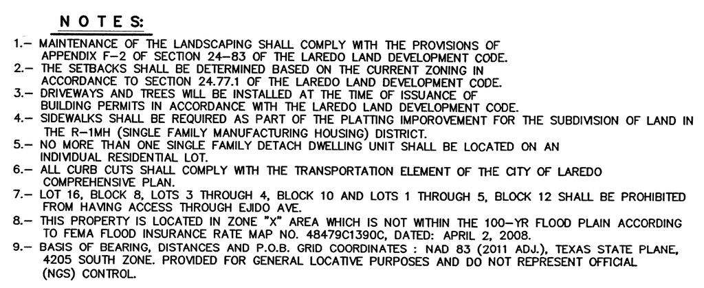
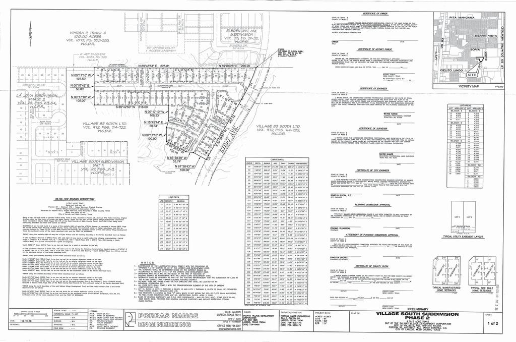
7 Planning and Zoning Commission- Regular Meeting Date: 01/03/2019 Staff Source: Karina L. Castillo, Planner APPLICANT: Salinas Village Development Corporation ENGINEER: Porras Nance Engineering Master Plans 6. B. REQUEST: Review and consideration of the Village South Subdivision Master Plan. The intent is residential and commercial. District 1 - Cm. Rudy Gonzalez, Jr. SITE: This acre tract is located north of Cielito Lindo Blvd. and west of Cuatro Vientos Rd. The zoning for this 733 lot development is AG, R-1A, R-1MH, B-1. This tract is located in District I- Cm. Rudy Gonzalez, Jr. PROPOSED ACTION: APPROVE SUBJECT TO THE FOLLOWING COMMENTS: Planning: 1. Provide a plat note with X, Y coordinates for point of beginning and point of commencement. 2. Submit master plan revision to City of Laredo Building Department GIS Division within 10 days of commission approval in a geo-referenced CAD file in accordance to Section 2-3.2(a) 4 of the City of Laredo Subdivision Ordinance. 3. Provide street names or designations (i.e.: Street A, Street B, etc.) for all phases. 4. Submit all proposed street names to the Planning Department for review and approval. 5. Conform to Section of the Laredo Land Development Code (Parkland Dedication requirements). 6. A copy of the master plan shall immediately be submitted to the Parks & Recreation Department of the City of Laredo as per Section A.4 of the Laredo Land Development Code. 7. All improvements as per Subdivision Ordinance. Engineering: 1. Detention pond phase shall be renumbered to be within the next phase. Fire: No comments submitted.
8 Environmental: No comments submitted. Water & Utilities: No comments submitted. Traffic Safety: No comments submitted. Parks & Leisure: 1. Parkland dedication needs to be submitted to Parks Advisory Committee for review and approval. These are the requirements according to Ordinance 2008-O-058: Parkland req'd = 724 residential lots / 256 = acres Total of NPIF*=$724 residential lots x $314 = 227, (to be paid prior to recordation) WEBB County App: No comments submitted. AEP Engineers: No comments submitted. U.I.S.D.: No comments submitted. L.I.S.D.: No comments submitted. AT&T: No comments submitted. NOTICE TO THE DEVELOPER: Planning: 1. All comments set forth herein are preliminary comments and not an exhaustive list. Additional comments may be added prior to final plat approval. Vicinity Map Village South Master Plan Attachments
9
10
11 Planning and Zoning Commission- Regular Meeting Date: 01/03/2019 Staff Source: Karina L. Castillo, Planner APPLICANT: JMLG Holdings, LTD. ENGINEER: Howland Engineering & Surveying Co. Master Plans 6. C. REQUEST: Review and reconsideration of the Los Presidentes East Master Plan. The intent is residential and commercial. The purpose of this revision is to reconfigure phases and realign streets. District II - Cm. Vidal Rodriguez SITE: This 170 acre tract is located west of Concord Hills Development and east of Cuatro Vientos Road. The zoning of this 185 lot development is AG, R-1, R-1A, and B-4. This tract is located in District II - Cm. Vidal Rodriguez. PROPOSED ACTION: APPROVAL SUBJECT TO THE FOLLOWING COMMENTS: Planning: 1. Provide a plat note with X, Y coordinates for point of beginning and point of commencement. 2. Submit master plan revision to City of Laredo Building Department GIS Division within 10 days of commission approval in a geo-referenced CAD file in accordance to Section 2-3.2(a) 4 of the City of Laredo Subdivision Ordinance. 3. Renumber phases beginning with Phase 1 and exclude the already recorded phases. 4. Clearly define boundaries of all phases. 5. Show all the recorded phases in solid lines. 6. Pond/Park should be constructed before the last phase. 7. No double frontage on lots along Street A/Avenida Los Presidentes, Street G/Avenida Los Presidentes, Tabasco Dr./Avenida Los Presidentes and along Jalapa St. in Phase Provide street names or designations (i.e.: Street A, Street B, etc.) for all phases. 9. Submit all proposed street names to the Planning Department for review and approval. 10. Access to Loop 20 is subject to review and approval from TxDOT. 11. A zone change will be required for intended use. 12. Conform to Section of the Laredo Land Development Code (Parkland
12 Dedication requirements). 13. A copy of the master plan shall immediately be submitted to the Parks & Recreation Department of the City of Laredo as per Section A.4 of the Laredo Land Development Code. 14. All improvements as per Subdivision Ordinance. Engineering: 1. Almost 20% of Master Plan has been platted. Detention pond phase shall be one of the next phases. Reorder phasing. Fire: 1. When is Phase 15 and 16 going to have access? Environmental: No comments submitted. Water & Utilities: No comments submitted. Traffic Safety: 1. Street G and the street that runs north-south need to intersect at a perpendicular angle. 2. Check sight distance at the cul-de-sac. 3. Streets B, F, C, and E are not aligned and are too close. 4. Some streets will need calming devices. 5. Check sight distance at Los Presidentes and Isla Mujeres. 6. Check sight distance at Cozumel and Jalapa. Parks & Leisure: 1. After reviewing the Los Presidentes East Subdivision Master Plan on file, it it showing substantial changes, therefore the remaining un-platted phases will have to comply with Ordinance 2008-O-058 Parkland requirements.we have received the submittal from Howland Engineering for Parkland Dedication and will be reviewed and presented on the next Parks Advisory Committee meeting. WEBB County App: No comments submitted. AEP Engineers: No comments submitted. U.I.S.D.: No comments submitted. L.I.S.D.: No comments submitted. AT&T: No comments submitted. NOTICE TO THE DEVELOPER:
13 Planning: 1. Only the utility easements within the plat boundaries are subject to change prior to plat recordation, due to revisions by the utility companies. Los Presidentes East Master Plan Attachments

14
15 Planning and Zoning Commission- Regular Meeting Date: 01/03/2019 Staff Source: Karina L. Castillo, Planner APPLICANT: Robert Muller, LTD ENGINEER: Civil Engineering Consultants Master Plans 6. D. REQUEST: Review and reconsideration of the revision of The New Trade Center Subdivision Master Plan. The intent is industrial. The purpose of this revision is the addition of easements on Lots 14 and 15 in Phase 3. District VII- Cm. George Altgelt SITE: This acre tract is located west of F.M and north of La Bota Ranch. The zoning for this 46 lot development is M-1. This tract is located in District VII- Cm. George Altgelt. PROPOSED ACTION: APPROVAL SUBJECT TO THE FOLLOWING COMMENTS: Planning: 1. Provide a plat note with X, Y coordinates for point of beginning and point of commencement. 2. Submit master plan revision to City of Laredo Building Department GIS Division within 10 days of commission approval in a geo-referenced CAD file in accordance to Section 2-3.2(a) 4 of the City of Laredo Subdivision Ordinance. 3. All improvements as Per Subdivision Ordinance. Engineering: No comments submitted. Fire: No comments submitted. Environmental: No comments submitted. Water & Utilities: No comments submitted. Traffic Safety: 1. Check sight distance on Trade Center and Free Trade. The curved roadway of Free
16 Trade will cause sight distance issues all along the curve and at the intersection of Trade Center. Parks & Leisure: No comments submitted. WEBB County App: No comments submitted. AEP Engineers: No comments submitted. U.I.S.D.: No comments submitted. L.I.S.D.: No comments submitted. AT&T: No comments submitted. NOTICE TO THE DEVELOPER: Planning: 1. Only the utility easements within the plat boundaries are subject to change prior to plat recordation, due to revisions by the utility companies. Plat Notes New Trade Center Master Plan Attachments
17
18
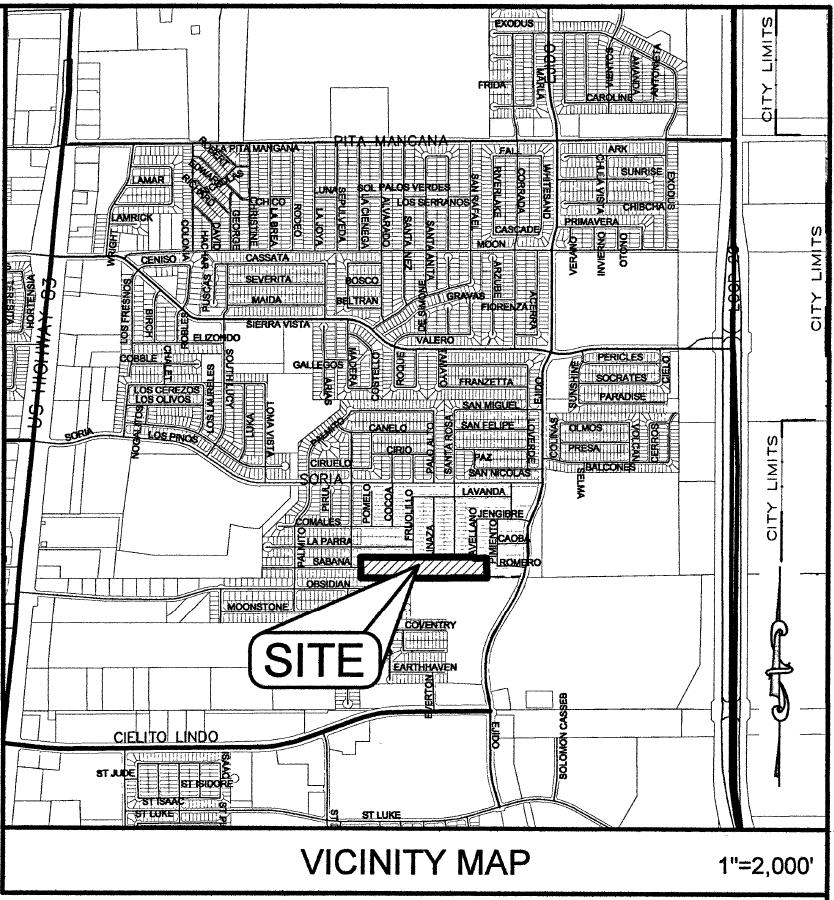
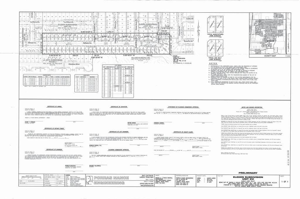
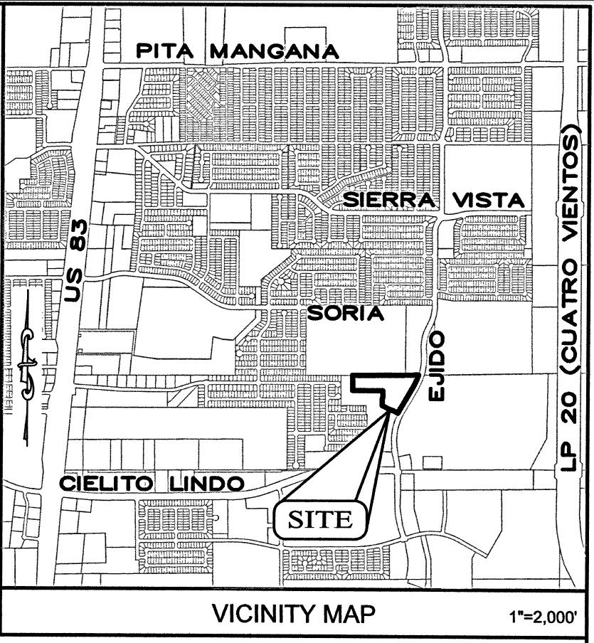
19 Preliminary Plats/Replats 7. A. Planning and Zoning Commission- Regular Meeting Date: 01/03/2019 Staff Source: Karina L. Castillo, Planner APPLICANT: VIMOSA II A Texas General Partnership ENGINEER: Porras Nance Engineering REQUEST: Preliminary consideration of the plat of Eleden Subdivision Unit XVI. The intent is residential. District I- Cm. Rudy Gonzalez, Jr. SITE: This acre tract is located south of Soria Dr. and west of Ejido Ave. The zoning for this 58 lot development is R-3. This tract is located in District I- Cm. Rudy Gonzalez, Jr. PROPOSED ACTION: APPROVE SUBJECT TO THE FOLLOWING COMMENTS: Planning: 1. Revise Attestment of Planning Approval signature line to say "Vanessa Guerra, Acting Planning Director." 2. All improvements as per Subdivision Ordinance. Engineering: No comments submitted. Fire: No comments submitted. Environmental: No comments submitted. Water & Utilities: No comments submitted. Traffic Safety: No comments submitted. Parks & Leisure: 1. Parkland dedication has been fulfilled. 2. Neighborhood Park improvement fee for this phase is: 58 residential lots x $314 = $18,212 prior to recordation WEBB County App: No comments submitted.
20 AEP Engineers: No comments submitted. U.I.S.D.: No comments submitted. L.I.S.D.: No comments submitted. AT&T: No comments submitted. NOTICE TO THE DEVELOPER: Planning: 1. Only the utility easements within the plat boundaries are subject to change prior to plat recordation, due to revisions by the utility companies. 2. All comments set forth herein are preliminary comments and not an exhaustive list. Additional comments may be added prior to final plat approval. Vicinity Map Plat Notes Eleden Subdivision Unit XVI Attachments
21
22
23
24 Preliminary Plats/Replats 7. B. Planning and Zoning Commission- Regular Meeting Date: 01/03/2019 Staff Source: Karina L. Castillo, Planner APPLICANT: Salinas Village Development Corporation ENGINEER: Porras Nance Engineering REQUEST: Preliminary consideration of the Plat of Village South Subdivision Phase 2. District I- Cm. Rudy Gonzalez, Jr. SITE: This acre tract is located north of Cielito Lindo Blvd. and west of Cuatro Vientos Rd. The zoning for this 61 lot development is R-1MH. This tract is located in District I- Cm. Rudy Gonzalez, Jr. PROPOSED ACTION: APPROVE SUBJECT TO THE FOLLOWING COMMENTS: Planning: 1. Revise Attestment of Planning Approval signature line to say "Vanessa Guerra, Acting Planning Director." 2. Revise lot dimensions to ensure that all lots meet the minimum lot areas, lot depths, and lot widths of the existing zoning. 3. Identify the 20' Utility Easement on Block All improvements as per Subdivision Ordinance. Engineering: No comments submitted. Fire: No comments submitted. Environmental: No comments submitted. Water & Utilities: No comments submitted. Traffic Safety: No comments submitted. Parks & Leisure: 1. Parkland dedication has to be submitted to Parks Advisory Committee for review
25 and approval prior to recordation. According to Ordinance 2008-O-058 the following are the requirements for this phase: Parkland req'd for this phase = 61 residential lots / 256 = acres Neighborhood Park Improvement Fee = 61 residential lots x $314 = $19,154 To be paid prior to recordation WEBB County App: No comments submitted. AEP Engineers: No comments submitted. U.I.S.D.: No comments submitted. L.I.S.D.: No comments submitted. AT&T: No comments submitted. NOTICE TO THE DEVELOPER: Planning: 1. Only the utility easements within the plat boundaries are subject to change prior to plat recordation, due to revisions by the utility companies. 2. All comments set forth herein are preliminary comments and not an exhaustive list. Additional comments may be added prior to final plat approval. Vicinity Map Plat Notes Village South Phase 2 Attachments
26
27
28
29 Preliminary Plats/Replats 7. C. Planning and Zoning Commission- Regular Meeting Date: 01/03/2019 Staff Source: Karina L. Castillo, Planner APPLICANT: Dean Saniditen Marital Trust ENGINEER: Howland Engineering & Surveying Co. REQUEST: Preliminary consideration of the Replat of Lot 1A, Block 9, Westgate Place Subdivision into Lot 1AA, Block 9, Westgate Place Subdivision. The intent is commercial. The purpose of this replat is to partially remove an existing 10' utility easement between Lots 1B, Block 9 and Lot 1, Block 5. District V- Cm. Norma "Nelly" Vielma. SITE: This 0.23 acre tract is located north of Calton Rd. and west of McPherson Rd. The zoning for this 1 lot development is B-3. This tract is located in District V- Cm. Norma "Nelly" Vielma. PROPOSED ACTION: APPROVE SUBJECT TO THE FOLLOWING COMMENTS: Planning: 1. Revise the title of the "Replat Into" to say "Replat of Lot 1A, Block 9, Westgate Place Subdivision into Lot 1AA, Block 9, Westgate Place Subdivision." 2. Submit the release letters for the Utility Easement that is being removed. 3. If there has not there been a replat on Lot 1B removing the 10' Utility Easement, show the 10' Utility Easement existing on Lot 1B since this replat is only removing the easement on Lot 1A. 4. Revise Attestment of Planning Approval signature line to say "Vanessa Guerra, Acting Planning Director." 5. All improvements as per Subdivision Ordinance. Engineering: 1. Do not delete 10' Utility Easement in Lot 9B, Block 9. Fire: No comments submitted. Environmental: No comments submitted.
30 Water & Utilities: No comments submitted. Traffic Safety: No comments submitted. Parks & Leisure: No comments submitted. WEBB County App: No comments submitted. AEP Engineers: No comments submitted. U.I.S.D.: No comments submitted. L.I.S.D.: No comments submitted. AT&T: No comments submitted. NOTICE TO THE DEVELOPER: Planning: 1. Only the utility easements within the plat boundaries are subject to change prior to plat recordation, due to revisions by the utility companies. 2. All comments set forth herein are preliminary comments and not an exhaustive list. Additional comments may be added prior to final plat approval. Vicinity Map Plat Notes Lot 1A, Block 9, Westgate Place Attachments
31
32
33
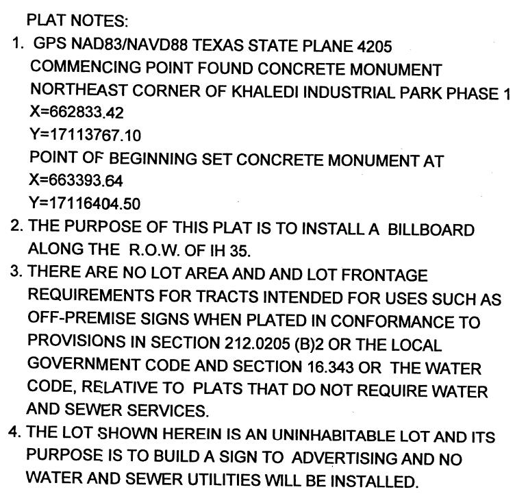
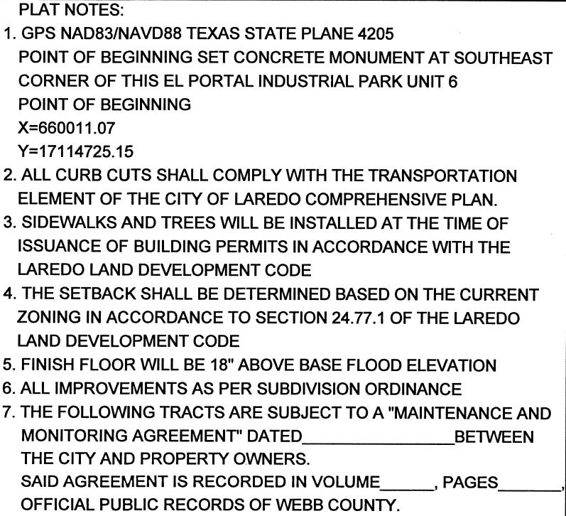
34 Planning and Zoning Commission- Regular Meeting Date: 01/03/2019 Staff Source: Karina L. Castillo, Planner APPLICANT: Detcen Holdings, LLC ENGINEER: Mejia Engineering Company Preliminary Plats/Replats 7. D. REQUEST: Preliminary consideration of the plat of Khaledi Industrial Park Billboard. The intent is for a billboard District VII - Cm. George Altgelt SITE: This 0.14 acre tract is located west of I35 and north of Bob Bullock Loop. The zoning for this 1 lot development is M-1. The tract is located in District VII - Cm. George Altgelt. PROPOSED ACTION: APPROVE SUBJECT TO THE FOLLOWING COMMENTS: Planning: 1. Revise Attestment of Planning Approval signature line to say "Vanessa Guerra, Acting Planning Director." 2. All improvements as per Subdivision Ordinance. Engineering: No comments submitted. Fire: No comments submitted. Environmental: No comments submitted. Water & Utilities: No comments submitted. Traffic Safety: No comments submitted. Parks & Leisure: No comments submitted. WEBB County App: No comments submitted. AEP Engineers: No comments submitted.
35 U.I.S.D.: No comments submitted. L.I.S.D.: No comments submitted. AT&T: No comments submitted. NOTICE TO THE DEVELOPER: Planning: 1. Only the utility easements within the plat boundaries are subject to change prior to plat recordation, due to revisions by the utility companies. 2. All comments set forth herein are preliminary comments and not an exhaustive list. Additional comments may be added prior to final plat approval. Vicinity Map Plat Notes Khaledi Industrial Park Billboard Attachments
36
37
38
39
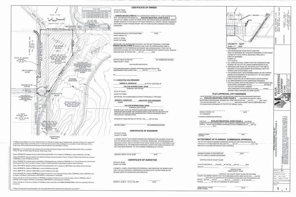
40 Planning and Zoning Commission- Regular Meeting Date: 01/03/2019 Staff Source: Karina L. Castillo, Planner APPLICANT: Detcen Holdings, LLC ENGINEER: Mejia Engineering Company Preliminary Plats/Replats 8. A. REQUEST: Preliminary reconsideration of the Plat of Khaledi Industrial Park Phase 4. The intent is industrial. District VII- Cm. George Altgelt SITE: This acre tract is located west of IH-35 and north of Bob Bullock Loop (Loop 20). The zoning for this 1 lot development is M-1. This tract is located in District VII- Cm. George Altgelt. PROPOSED ACTION: APPROVE SUBJECT TO THE FOLLOWING COMMENTS: Planning: 1. All improvements as per Subdivision Ordinance. Engineering: No comments submitted. Fire: No comments submitted. Environmental: No comments submitted. Water & Utilities: No comments submitted. Traffic Safety: No comments submitted. Parks & Leisure: No comments submitted. WEBB County App: No comments submitted. AEP Engineers: No comments submitted. U.I.S.D.: No comments submitted.
41 L.I.S.D.: No comments submitted. AT&T: No comments submitted. NOTICE TO THE DEVELOPER: Planning: 1. Only the utility easements within the plat boundaries are subject to change prior to plat recordation, due to revisions by the utility companies. 2. All comments set forth herein are preliminary comments and not an exhaustive list.additional comments may be added prior to final plat approval. Vicinity Map Plat Notes Khaledi Industrial Park Phase 4 Attachments
42
43
44
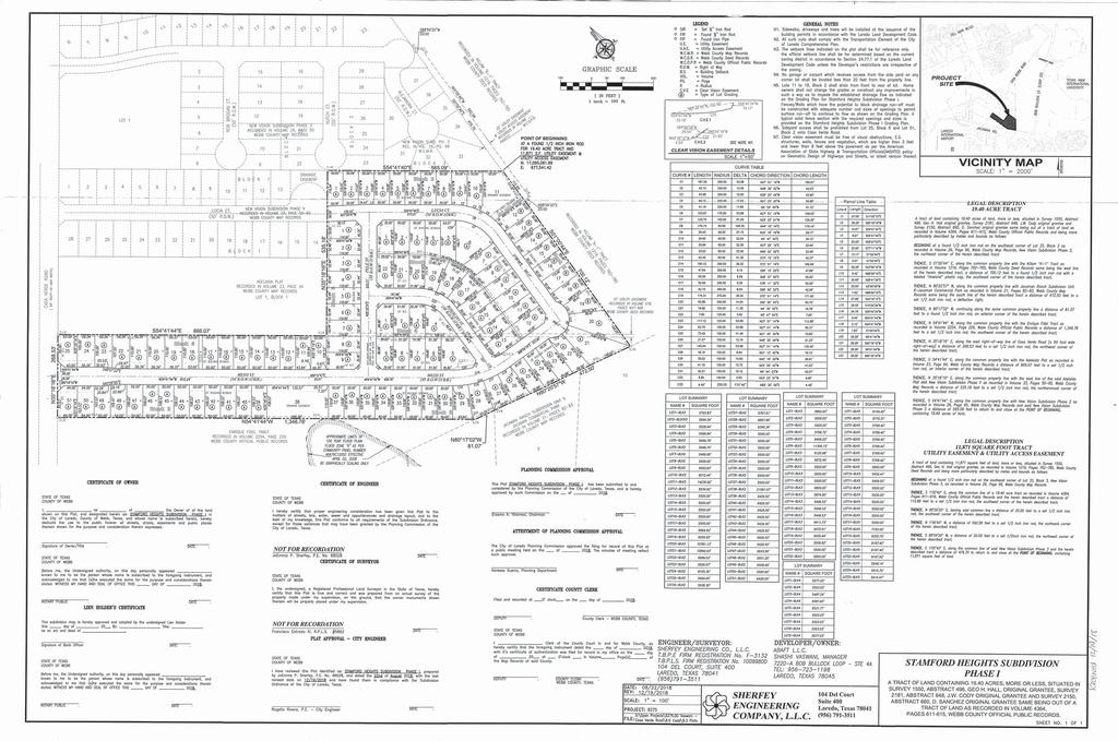
45 Planning and Zoning Commission- Regular Meeting Date: 01/03/2019 Staff Source: Karina L. Castillo, Planner APPLICANT: Abaft, L. L. C. ENGINEER: Sherfey Engineering Company, L. L. C. Final Plats/Replats 9. A. REQUEST: Final consideration of the Stamford Heights Subdivision Plat. The intent is residential. District V - Cm. Norma "Nelly" Vielma SITE: This 19.4 acre tract is located north of Jacaman Rd. and east of Casa Verde Rd. The zoning for this 107 lot development is R-1. This tract is located in District V - Cm. Norma "Nelly" Vielma. PROPOSED ACTION: APPROVAL. Vicinity Map Plat Notes Stamford Heights Subdivision Attachments
46
47
48
AGENDA ITEM: VIII-A DATE: 04/06/17 APPLICANT: AR Sanchez, Jr. ENGINEER: Crane Engineering REQUEST: Review and consideration of the Southern Developmen
 AGENDA ITEM: VIII-A DATE: 04/06/17 APPLICANT: AR Sanchez, Jr. ENGINEER: Crane Engineering REQUEST: Review and consideration of the Southern Development Subdivision Master Plan. The intent is residential
CITY OF LAREDO PLANNING AND ZONING COMMISSION
 CITY OF LAREDO PLANNING AND ZONING COMMISSION MINUTES OF THE PLANNING AND ZONING MEETING OF FEBRUARY 15, 2017 The City of Laredo Planning and Zoning Commission convened in special session open to the public
PLANNING AND ZONING COMMISSION NOTICE OF PUBLIC MEETING
 PLANNING AND ZONING COMMISSION NOTICE OF PUBLIC MEETING City of Laredo City Hall City Council Chambers 1110 Houston Street Laredo, Texas October 18, 2018 6:00 p.m. MEETING AGENDA 1. CALL TO ORDER 2. ROLL
PLANNING AND ZONING COMMISSION
 PLANNING AND ZONING COMMISSION NOTICE OF PUBLIC MEETING City of Laredo City Hall City Council Chambers 1110 Houston Street Laredo, Texas September 20, 2018 6:00 p.m. MEETING AGENDA 1. CALL TO ORDER - :.
PLANNING AND ZONING COMMISSION
 PLANNNG AND ZONNG COMMSSON NOTCE OF PUBLC MEETNG City of Laredo City Hall City Council Chambers 1ll0 Houston Street Laredo, Texas September 1, 2016 6:00p.m. AMENDED MEETNG AGENDA. CALL TO ORDER.. V. ROLL
MINOR PLAT. The following documents are provided as required by the City of Conroe for use in the above titled platting submittals:
 Public Works - Engineering Division CITY OF CONROE MINOR PLAT The following documents are provided as required by the City of Conroe for use in the above titled platting submittals: Submittal Questionnaire
Planning & Zoning Commission
 Planning & Zoning Commission Planning & Development Department March 3, 2014 Final Plat Bay View Section 2, Phase I Request Applicant Owner Zoning Location Attachments Subdivision of approximately 12.04
APPLICATION FOR MAJOR SUBDIVISION APPROVAL (PRELIMINARY PLAT)
") 209 S. Main Street Marysville, Ohio 43040 Phone: (937) 645-7350 Fax: (937) 645-7351 www.marysvilleohio.org APPLICATION FOR MAJOR SUBDIVISION APPROVAL (PRELIMINARY PLAT) *** IMPORTANT INFORMATION ~ Please
209 S. Main Street Marysville, Ohio 43040 Phone: (937) 645-7350 Fax: (937) 645-7351 www.marysvilleohio.org APPLICATION FOR MAJOR SUBDIVISION APPROVAL (PRELIMINARY PLAT) *** IMPORTANT INFORMATION ~ Please
DAUPHIN CREEK ESTATES SUBDIVISION
 # 12 SUB-000076-2017 DAUPHIN CREEK ESTATES SUBDIVISION Engineering Comments: FINAL PLAT COMMENTS (should be addressed prior to submitting the FINAL PLAT for review and/or signature by the City Engineer):
Preliminary Plat/Final Plat Application
 Melissa Municipal Center 3411 Barker Avenue Melissa, Texas 75454 Phone: (972) 838-2036 Applicant: Date: Address: Phone: Contact: Fax: E-mail: Propose Addition Name: Acres: Existing Zoning: Propose Zoning:
Subdivision - Minor Plat Submittal
 Subdivision - Minor Plat Submittal This Checklist is intended to provide the information and data that is necessary to assess the merits of the project proposal. Please note that this Checklist is intended
610 LAND DIVISIONS AND PROPERTY LINE ADJUSTMENTS OUTSIDE A UGB
 ARTICLE VI: LAND DIVISIONS AND PROPERTY LINE ADJUSTMENTS VI-21 610 LAND DIVISIONS AND PROPERTY LINE ADJUSTMENTS OUTSIDE A UGB 610-1 Property Line Adjustments (Property Line Relocation) A property line
PRELIMINARY PLATS. The following documents are provided as required by the City of Conroe for use in the above titled platting submittals:
 Public Works Engineering Division CITY OF CONROE PRELIMINARY PLATS The following documents are provided as required by the City of Conroe for use in the above titled platting submittals: Submittal Questionnaire
Section Preliminary Plat Checklist and Application Forms
 Section 201 - Preliminary Plat Checklist and Application Forms PRELIMINARY SUBDIVISION PLAT REVIEW PROCESS CHART PRELIMINARY SUBDIVISION PLAT APPLICATION PRELIMINARY PLAT REVIEW CHECKLIST CITY OF NAMPA
STONE COUNTY PRELIMINARY PLAT CHECKLIST. Note: Applications need to be in the office by 2 p.m. on the cutoff day.
 STONE COUNTY PRELIMINARY PLAT CHECKLIST Note: Applications need to be in the office by 2 p.m. on the cutoff day. JOY WILSON, DIRECTOR Return form to: Planning & Zoning Administrator PO Box 301, Galena,
Department of Planning & Development Services
 Department of Planning & Development Services S T A F F R E P O R T February 9, 2015 CASE NO: PROJECT: EXECUTIVE SUMMARY: ZA14-154 Plat Revision for Lots 25R-1A, 25R-1B and 25R-1C, Block 1, Woodland Heights
FINAL PLAT. Community Development Department 8101 Ralston Road Arvada, Colorado 80002
 FINAL PLAT Community Development Department 8101 Ralston Road Arvada, Colorado 80002 September 2015 FINAL SUBDIVISION PLAT Final Subdivision Plat Review Applications for a Final Plat shall be submitted
CITY OF STRONGSVILLE PLANNING COMMISSION APPLICATION CLUSTER SUBDIVISION
 CITY OF STRONGSVILLE PLANNING COMMISSION APPLICATION CLUSTER SUBDIVISION After meeting with City Planner, George Smerigan (if necessary) regarding zoning requirements, submit the following: An application
Application for Preliminary Plat Checklist
 Application for Preliminary Plat Checklist Note: No portion of an existing parcel may be sold or transferred to another party without first legally subdividing the property according to the City of Richmond
LAND USE APPLICATION
 Lincoln County Department of Planning & Development 210 SW 2nd Street, Newport, OR 97365 Phone (541) 265-4192 Fax (541) 265-6945 LAND USE APPLICATION TO BE COMPLETED BY STAFF Conditional Use Non-Conforming
SUBDIVISION AND LAND DEVELOPMENT. 185 Attachment 20
 185 Attachment 20 APPENDIX S Plat No. Date of Submission Twp. Fee $ Dauphin Co. Fee $ TOWNSHIP OF DERRY SUBDIVISION OR LAND DEVELOPMENT PLAN SUBMISSION APPLICATION This block for Twp. use only 1. Title
TOWN OF LEWISTON PLANNING BOARD APPLICATION
 TOWN OF LEWISTON PLANNING BOARD APPLICATION DESCRIPTION OF PROPOSED REQUEST: Name of Property Owner: Phone #: Name of Applicant:Phone #: Address or Location of Proposal:_SBL# Size of Parcel or Structure:Existing
PROCEDURE. Chapter 12: Subdivision Regulations
 SECTION 14-600 ADMINISTRATIVE REPLAT PROCEDURE 14-601 INTENT These procedures are to provide an abbreviated process for Replat applications that demonstrate compliance with the criteria contained herein.
Residential Major Subdivision Review Checklist
 Residential Major Subdivision Review Checklist Plan Submittal Requirements: 2 full sets of stamped plans Electric submittal - all plans contained in a single PDF 3 full sets if commercial kitchen or dining
BRIDGETON SUBDIVISION APPLICATION CHECKLIST
 APPLICATION NAME AND # CHECKLIST COMPLETED BY: DATE: Signature and printed name BRIDGETON SUBDIVISION APPLICATION CHECKLIST TO SUBDIVISION APPLICANTS: The attached checklist is to assist you in the submission
CONCEPT PLAN APPLICATION Meeting with Staff Commercial Projects
 COMMUNITY DEVELOPMENT City of South Salt Lake Community Development Department 220 E. Morris Avenue South Salt Lake City, Utah 84115 Phone (801) 483-6011 Fax (801) 483-6060 CONCEPT PLAN APPLICATION Meeting
HERMISTON PLANNING COMMISSION. Regular Meeting May 10, 2017
 HERMISTON PLANNING COMMISSION Regular Meeting May 10, 2017 Commissioner Saylor called the meeting to order at 7:00 PM. Commissioners Caplinger, Doherty, Hamm, Flaiz, Fialka and Frederic were present. Commissioners
Plat Checklist PLAT TYPES AND DESCRIPTIONS
 Master Plan / Revision to Master Plan (For Platting Purposes Only) Preliminary/Final Plat Preliminary Plat Final Plat Minor Plat Replat Amended Plat Plat Checklist So that we may efficiently review your
Staff Report to the North Ogden Planning Commission
 Staff Report to the North Ogden Planning Commission SYNOPSIS / APPLICATION INFORMATION Application Request: Consideration and action on an administrative application for final approval for the Legacy North
SUBMITTAL REQUIREMENTS: The number indicates the number of copies for submittal (if applicable).
.") Office Use Only Preliminary Long Plat Long Subdivision Applicant Checklist PLANNING, COMMUNITY, & ECONOMIC DEVELOPMENT DEPARTMENT FINAL LONG PLAT LONG SUBDIVISION CHECKLIST Mailing Address: P.O. Box 547,
Office Use Only Preliminary Long Plat Long Subdivision Applicant Checklist PLANNING, COMMUNITY, & ECONOMIC DEVELOPMENT DEPARTMENT FINAL LONG PLAT LONG SUBDIVISION CHECKLIST Mailing Address: P.O. Box 547,
CHAPTER 25 REVIEW AND APPROVAL OF SITE CONDOMINIUM AND CONDOMINIUM PROJECTS
 CHAPTER 25 REVIEW AND APPROVAL OF SITE CONDOMINIUM AND CONDOMINIUM PROJECTS Section 25.1. Purpose and Scope. 1. Tracts of land that are developed and sold as site condominium developments and condominium
AMENDING PLAT REQUIREMENTS Revised
 City of University Park AMENDING PLAT REQUIREMENTS Revised 10-2016 1. The amending plat is prepared with the appropriate certificates printed on the document and three (3) 24 x 36 paper copies are submitted
HERON LANDING SUBDIVISION
 HERON LANDING SUBDIVISION Engineering Comments: Per FEMA guidelines, any development greater than 5 acres in size or subdivision 50 lots in size, requires a flood study. Width of drainage easement to be
RESOLUTION NO. ZR
 RESOLUTION NO. ZR-2015-004 RESOLUTION APPROVING ZONING APPLICATION SV/ZV/Z-2014-01624 (CONTROL NO. 2009-02465) TYPE II VARIANCE (CONCURRENT) APPLICATION OF MPC 3 LLC BY CPH, Inc, Baker & Hostetler LLP,
Staff Report to the North Ogden City Council
 Staff Report to the North Ogden City Council SYNOPSIS / APPLICATION INFORMATION Application Request: Consideration and action on an administrative application to provide comments on the preliminary plan
JUSTIFICATION STATEMENT Minor Subdivision - Plat Raymond F. Kravis Center for the Performing Arts, Inc. Initial Submittal: September 11, 2018
 JUSTIFICATION STATEMENT Minor Subdivision - Plat Raymond F. Kravis Center for the Performing Arts, Inc. Initial Submittal: September 11, 2018 REQUEST On behalf of the Applicant, WGI is requesting a Minor
RESOLUTION NO. R
 RESOLUTION NO. R-2016-1832 RESOLUTION APPROVING ZONING APPLICATION ZV/DOAlR-2016-00660 (CONTROL NO. 1998-00089) a Requested Use APPLICATION OF 2860 Ranch House Road LLC, Scotts Gas LLC, Ranch House Prop
THE CITY OF MOBILE, ALABAMA
 THE CITY OF MOBILE, ALABAMA LETTER OF DECISION March 9, 2018 Byrd Surveying, Inc. 2609 Halls Mill Road Mobile, AL 36606 Re: 4439 Rangeline Road (Northwest corner of Rangeline Road and Halls Mill Road).
Planning & Zoning Commission
 Planning & Zoning Commission Preliminary Plat Tuscan Lakes, SF 55-3 and 60-3 SE Planning & Development Department May 4, 2015 Request Applicant Owner Zoning Location Attachments Subdivide approximately
CITY OF LAREDO, TEXAS SUBDIVISION ORDINANCE HANDBOOK APPENDIX B OF THE CODE OF ORDINANCES
 CITY OF LAREDO, TEXAS SUBDIVISION ORDINANCE HANDBOOK APPENDIX B OF THE CODE OF ORDINANCES HANDBOOK OF THE SUBDIVISION ORDINANCE OF THE CITY OF LAREDO, TEXAS APPENDIX B OF THE CODE OF ORDINANCES CITY OF
Residential Minor Subdivision Review Checklist
 Residential Minor Subdivision Review Checklist Plan Submittal Requirements: 2 full sets of stamped plans Electric submittal - all plans contained in a single PDF 3 full sets if commercial kitchen or dining
City of Colleyville Community Development Department. Subdivision Application Packet
 Community Development Department Subdivision Application Packet 1 Development Application Fees 100 Main Street Colleyville TX 76034 817.503.1050 Zoning Zoning Change $ 500 + $5 per acre Planned Unit Development
Planning & Zoning Commission
 Planning & Zoning Commission Planning & Development Department March 21, 2016 Master Plan Revision Westwood Subdivision, Revision #3 Request Applicant Owner Zoning Location Attachments Background Site
MAJOR RESIDENTIAL AND NONRESIDENTIAL SUBDIVISIONS
 Lawrence-Douglas County MAJOR RESIDENTIAL AND NONRESIDENTIAL SUBDIVISIONS Preliminary Plats The applicant shall schedule a Pre-Application meeting with Planning Staff at least seven (7) working days prior
EDGEWATER PLANNING AND ZONING COMMISSION RESOLUTION NO. PC
 EDGEWATER PLANNING AND ZONING COMMISSION RESOLUTION NO. PC 2019-02 A RESOLUTION CONDITIONALLY APPROVING A PRELIMINARY PLAT OF PARCELS A, B, C, D, E AND F, IN THE SOUTHEAST ¼ OF THE SOUTHWEST ¼ OF SECTION
Guide to Replats. Step 1. Step 2. Step 3. Step 4. Step 5. Step 6. Step 7. Step 8. Step 9. Step 10
 Guide to Replats Introduction Douglas County is committed to providing open, transparent application processes to the public. This Guide is provided to assist anyone interested in the procedures and expectations
BOSSIER CITY PARISH METROPOLITAN PLANNING COMMISSION 620 Benton Rd. Bossier City, LA Phone: Fax: PRELIMINARY PLAT
 (OFFICE USE ONLY) Application Fee: Paid: Date: CASE # Project Information BOSSIER CITY PARISH METROPOLITAN PLANNING COMMISSION 620 Benton Rd. Bossier City, LA 71111 Phone: 318-741-8824 Fax: 318-741-8827
WASTEWATER BACKFLOW RELEASE PROCEDURES
 WASTEWATER BACKFLOW RELEASE PROCEDURES PROCEDURE FOR OBTAINING A WASTEWATER RELEASE FOR PRIVATE DEVELOPMENT PROJECTS: PLEASE NOTE THAT THE WASTEWATER BACKFLOW RELEASE DOCUMENT MUST FOLLOW THE CITY S PROCEDURES.
Department of Planning & Development Services
 Department of Planning & Development Services S T A F F R E P O R T CASE NO: ZA15-116 November 10, 2015 PROJECT: Preliminary Plat for Kingdom Place EXECUTIVE SUMMARY: REQUEST DETAILS: DeOtte Inc. is requesting
CITY OF STRONGSVILLE PLANNING COMMISSION APPLICATION SINGLE FAMILY SUBDIVISION
 CITY OF STRONGSVILLE PLANNING COMMISSION APPLICATION SINGLE FAMILY SUBDIVISION After meeting with City Planner, George Smerigan (if necessary) regarding zoning requirements, submit the following: Pursuant
TO: Glynn County Islands Planning Commission. Eric Landon, Planner II. PP2754 Stones Throw Cottages. DATE: February 6, 2014
 COMMUNITY DEVELOPMENT DEPARTMENT Planning and Zoning Division 1725 Reynolds Street, Suite 200, Brunswick, GA 31520 Phone: 912-554-7428/Fax: 1-888-252-3726 TO: Glynn County Islands Planning Commission FROM:
CITY OF JOPLIN, MISSOURI
 APPENDIX 29-B SUBDIVISION ORDINANCE PROPOSED REVISIONS Table of Contents Sec. 1. General Provisions Sec. 2. Definitions See. 3. Subdivision Platting Procedures Sec. 4. General Planning Standards Sec. 5.
LAND USE APPLICATION
 LAND USE APPLICATION File Name: File No(s).: Receipt No.: Receipt Date: Received By: Amount.: $ Instructions for Applicants Please read and follow all instructions on your application carefully. If you
ARTICLE 3 DEFINITIONS
 Sections: 3-1 Rules of Construction 3-2 Definitions ARTICLE 3 DEFINITIONS SECTION 3-1 RULES OF CONSTRUCTION 3-101. a. The language set forth in these regulations shall be interpreted in accordance with
Oakland County Michigan Register of Deeds Plat Engineering, GIS, & Remonumentation Dept. Ph: (248) Fax (248)
 Fax (248)") Oakland County Michigan Register of Deeds Plat Engineering, GIS, & Remonumentation Dept. Ph: (248)-858-1447 Fax (248)-858-7466 Requirements Needed for Final Plat Approval No. General Requirements. 1 Routing
Oakland County Michigan Register of Deeds Plat Engineering, GIS, & Remonumentation Dept. Ph: (248)-858-1447 Fax (248)-858-7466 Requirements Needed for Final Plat Approval No. General Requirements. 1 Routing
ARTICLE VI. SUBDIVISION STANDARDS, PUBLIC
 ARTICLE VI. SUBDIVISION STANDARDS, PUBLIC IMPROVEMENTS, AND DESIGN REQUIREMENTS ARTICLE VI. SUBDIVISION STANDARDS, PUBLIC IMPROVEMENTS, AND DESIGN REQUIREMENTS DIVISION 1. GENERAL PROVISIONS Sec. 21-6100.
MONTGOMERY COUNTY PLANNING DEPARTMENT THE MARYLAND-NATIONAL CAPITAL PARK AND PLANNING COMMISSION
 MONTGOMERY COUNTY PLANNING DEPARTMENT THE MARYLAND-NATIONAL CAPITAL PARK AND PLANNING COMMISSION MCPB Item No. Date: 12/4/14 Preliminary Plan No. 120140200, Northwood Knolls Description Patrick Butler,
RESPONSIVE RESULTS-ORIENTED TRUST-BUILDERS ACCOUNTABLE
 RESPONSIVE RESULTS-ORIENTED TRUST-BUILDERS ACCOUNTABLE PZ - 0015 Staff Report City of Pearland TO: Planning and Zoning Commission FROM: Planning and Community Development MEETING: Planning & Zoning - 20
Administrative Plat Application Form
 1 Administrative Plat Application Form This form shall be submitted with each application for an administrative plat. CONTACT INFORMATION Applicant Architect (if different) Property Owner (if different)
Boundary Line Adjustment Application
 Boundary Line Adjustment Application A COMPLETE APPLICATION is required at the time of submittal. REQUIRED SUBMITTALS: 1. Application form 2. Application Fee - $500.00. 3. Current title report 4. Three
FINAL SUBDIVISION AND LAND DEVELOPMENT PLAN CHECKLIST. Plan Name. Applicant's Name:
 TOWNSHIP OF UPPER ST. CLAIR FINAL SUBDIVISION AND LAND DEVELOPMENT PLAN CHECKLIST Date Filed Plan Name PLC Applicant's Name: Phone Filing Date for Final Application Final Plat 114.22. FINAL APPLICATION
Planning & Zoning Commission
 Zoning Change 13-03 (FM 646) Planning & Zoning Commission Planning & Development Department June 3, 2013 Request Permitted Uses Rezone approximately 24.89 acres of undeveloped land from RSF-7 (Residential
SUBMITTAL REQUIREMENTS: The number indicates the number of copies for submittal (if applicable).
.") Office Use Only Preliminary Long Plat Long Subdivision Applicant Checklist PLANNING, COMMUNITY, & ECONOMIC DEVELOPMENT DEPARTMENT PRELIMINARY LONG PLAT LONG SUBDIVISION CHECKLIST Mailing Address: P.O.
Office Use Only Preliminary Long Plat Long Subdivision Applicant Checklist PLANNING, COMMUNITY, & ECONOMIC DEVELOPMENT DEPARTMENT PRELIMINARY LONG PLAT LONG SUBDIVISION CHECKLIST Mailing Address: P.O.
Springfield Township, Bucks County. Planning Commission Meeting MINUTES. August 4, 2004
 Springfield Township, Bucks County 2320 Township Road Quakertown, PA 18951 Planning Commission Meeting MINUTES August 4, 2004 The meeting was called to order at 7:00 p.m. by Acting Chairman Brad Schultz.
SUBDIVISION PLAT CHECKLIST. The following information shall be include on the plat:
 SUBDIVISION PLAT CHECKLIST Subdivision Name: Land Surveyor: Owner/Developer: Date Submitted: The following information shall be include on the plat: The plat shall be drawn at a scale of one inch equals
A. The Preliminary Development Plan consists of five Sheets, as follows:
 Rezoning from A (Agriculture) to RPD (Residential Planned Development) and Approval of a Preliminary Development Plan and Preliminary Subdivision Plat. Wild Plum Farm. Applicant: JPB Holdings LLC, Property
CITY OF LA VISTA SUBDIVISION REGULATIONS SARPY COUNTY, NEBRASKA ORDINANCE NUMBER 1211 ADOPTED BY THE CITY OF LA VISTA, NEBRASKA FEBRUARY 4, 2014
 CITY OF LA VISTA SARPY COUNTY, NEBRASKA SUBDIVISION REGULATIONS ORDINANCE NUMBER 1211 ADOPTED BY THE CITY OF LA VISTA, NEBRASKA FEBRUARY 4, 2014 LA VISTA, NEBRASKA - SUBDIVISION REGULATIONS - 2014 I Table
Planning and Zoning Commission STAFF REPORT
 TO: FROM: Planning and Zoning Commission STAFF REPORT CASA GRANDE PLANNING AND ZONING COMMISSION James Gagliardi, AICP, City Planner MEETING DATE: September 1, 2016 REQUEST AGENDA # Request by Marshall
MINOR SUBDIVISION PLAT
 MINOR SUBDIVISION PLAT Community Development Department 8101 Ralston Road Arvada, Colorado 80002 MINOR SUBDIVISION PLAT Subdivisions consisting of five (5) or fewer lots are eligible for the minor subdivision
TO: Glynn County Islands Planning Commission. Karl W. Bursa, AICP, Planner II. PP3105 Stillwater Phase III. DATE: November 10, 2015
 COMMUNITY DEVELOPMENT DEPARTMENT Planning and Zoning Division 1725 Reynolds Street, Suite 200, Brunswick, GA 31520 Phone: 912-554-7428/Fax: 1-888-252-3726 TO: Glynn County Islands Planning Commission FROM:
To provide for the review of the final engineering plans, the subdivision improvement agreement, public dedications, and other legal agreements.
 ARTICLE 5 FINAL PLAT 501 Intent DOUGLAS COUNTY SUBDIVISION RESOLUTION To provide for the review of the final engineering plans, the subdivision improvement agreement, public dedications, and other legal
Initial Project Review
 Pierce County Department of Planning and Land Services, 2401 South 35th Street, Tacoma, WA (253) 798-7037 Initial Project Review Major Amendment to Preliminary Plat: Hawks Ridge Division 1 Application
SUBDIVISION APPLICATION
 SUBDIVISION APPLICATION Preliminary Plat Minor Plat Final Plat Amended Plat Applicant Name: Owner (if different from applicant) Name: Company: Company: Address: Address: City, State, Zip City, State, Zip
THE CITY OF MOBILE, ALABAMA
 THE CITY OF MOBILE, ALABAMA LE 'I IER OF DECISION Kimberly Clark Mobile Operations 200 Africatown Blvd. Prichard, AL 36610 Re: 100 & 200 Africatown Boulevard (Northeast corner of Bay Bridge Road and Paper
MINOR SUBDIVISION PLAT
 MINOR SUBDIVISION PLAT Community Development Department 8101 Ralston Road Arvada, Colorado 80002 September 2015 MINOR SUBDIVISION PLAT Subdivisions consisting of five (5) or fewer lots are eligible for
Planning Commission Final Plat Liverpool Fields, Phase 3 Liverpool Township App. No PP EXECUTIVE SUMMARY
 Planning Commission Final Plat Liverpool Fields, Phase 3 Liverpool Township App. No. 59-21-PP Meeting: August 6, 21 Applicant: Pride One Liverpool, LLC Owner: Pride One Liverpool, LLC Engineer: TGC Engineering
ARTICLE IV: DEVELOPMENT STANDARDS
 ARTICLE IV: DEVELOPMENT STANDARDS IV-53 409 PRIVATE STREETS A private street means any way that provides ingress to, or egress from, property by means of vehicles or other means, or that provides travel
M E M O R A N D U M. Planning and Zoning Commission. Daniel Turner, Planner I
 M E M O R A N D U M Meeting Date: Monday, April 10, 2017 Item No. F-4 To: From: Planning and Zoning Commission Daniel Turner, Planner I Subject: Consider a recommendation of a Preliminary Site Evaluation
THE COUNTY BOARD OF SUPERVISORS OF THE COUNTY OF DOUGLAS DOES ORDAIN AS FOLLOWS:
 8.1 SUBDIVISION CONTROL ORDINANCE THE COUNTY BOARD OF SUPERVISORS OF THE COUNTY OF DOUGLAS DOES ORDAIN AS FOLLOWS: SECTION I. GENERAL INTERPRETATION This ordinance shall not repeal, impair or modify private
SECTION 10 STANDARD PLATS
 SECTION 10 - STANDARD PLATS Subdivision 1: Purpose Standard Plats allow the subdivision of land into lots smaller than the minimum metes and bounds size in the zoning district, and control road development
CITY OF LAREDO CITY COUNCIL MEETING A99-R-12 CITY COUNCIL CHAMBERS 1110 HOUSTON STREET LAREDO, TEXAS APRIL 26, :30 P.M.
 CITY OF LAREDO CITY COUNCIL MEETING A99-R-12 CITY COUNCIL CHAMBERS 1110 HOUSTON STREET LAREDO, TEXAS 78040 APRIL 26, 1999 5:30 P.M. I. CALL TO ORDER II. PLEDGE OF ALLEGIANCE III. ROLL CALL IV. INTRODUCTORY
DOUGLAS COUNTY SUBDIVISION RESOLUTION Article 7 Replat 10/13/2015
 ARTICLE 7 REPLAT 701 Intent To provide a review process for the replatting of an existing subdivision plat or superblock final plat. The process shall vary according to the nature of the proposed amendment,
Letter of Intent May 2017 (Revised November 2017)
") THE BEACH AT WOODMOOR LETTER OF INTENT MAY 2017 (REVISED NOVEMBER 2017) OWNER/APPLICANT: CONSULTANT: Lake Woodmoor Holdings LLC N.E.S. Inc. 1755 Telstar Drive, Suite 211 619 North Cascade Avenue Colorado
THE BEACH AT WOODMOOR LETTER OF INTENT MAY 2017 (REVISED NOVEMBER 2017) OWNER/APPLICANT: CONSULTANT: Lake Woodmoor Holdings LLC N.E.S. Inc. 1755 Telstar Drive, Suite 211 619 North Cascade Avenue Colorado
P-14024, Staff Report for the Flanders Mill Phase 1-7 Subdivision
 Page 1 of 50 P-14024, Staff Report for the Flanders Mill Phase 1-7 Subdivision NOTE: UPDATES TO THIS STAFF REPORT THAT HAVE BEEN MADE SINCE ITS PRESENTATION TO THE PLANNING BOARD ARE SHOWN IN RED. Public
DALLAS WATER UTILITIES WATER/WASTEWATER COVENANT
 DALLAS WATER UTILITIES WATER/WASTEWATER COVENANT Procedure for obtaining a water and wastewater covenant, water covenant, or wastewater covenant; Required for initial submittal: 1. One letter from the
COMMUNITY DEVELOPMENT DEPARTMENT 333 Broadalbin Street SW, P.O. Box 490 Albany OR 97321
 COMMUNITY DEVELOPMENT DEPARTMENT 333 Broadalbin Street SW, P.O. Box 490 Albany OR 97321 NOTICE OF DECISION DATE OF NOTICE: August 16, 2016 FILE: TYPE OF APPLICATION: REVIEW BODY: SD-01-16 Ph: 541-917-7550
"Department" shall mean the East Point Department of Planning and Zoning, or any successor to that department.
 CHAPTER 8. UNIFORM ROADWAY ADDRESSING SYSTEM ARTICLE A. Sec. 10-8001. PURPOSE AND INTENT The City Council finds that the efficient and prompt provision of emergency services is essential to the health,
PLANNING COMMISSION REPORT Regular Agenda Non Public Hearing Item
 PC Staff Report 3/23/15 FDP-14-00551 Item No. 2-1 PLANNING COMMISSION REPORT Regular Agenda Non Public Hearing Item PC Staff Report 3/23/15 ITEM NO. 2: FINAL DEVELOPMENT PLAN FOR HUTTON FARMS WEST PHASE
DEPARTMENT OF PLANNING JEFFERSON PARISH, LOUISIANA
 DEPARTMENT OF PLANNING JEFFERSON PARISH, LOUISIANA SUBDIVISION REPORT DOCKET NO: SUMMARY NO: 24266 COUNCIL DISTRICT: 3: Mark D. Spears, Jr. COUNCIL AT LARGE: A - Chris Roberts B - Elton M. Lagasse ADVERTISING
ARTICLE 23 CONDOMINIUM STANDARDS
 ARTICLE 23 CONDOMINIUM STANDARDS Section 23.01 Intent. The intent of this Article is to provide regulatory standards for condominiums and site condominiums similar to those required for projects developed
COLLIN COUNTY SUBDIVISION REGULATIONS. Department of Engineering
 COLLIN COUNTY SUBDIVISION REGULATIONS Department of Engineering Updated: November 5, 2012 1 TABLE OF CONTENTS DEFINITIONS... 4 SECTION I - PRELIMINARY PLAT... 7 A. SUBDIVISION NAME AND STREET NAMES...
Preliminary Re-Plat Application & Submittal Checklist
 City of Live Oak Planning & Zoning Department 8001 Shin Oak Drive Live Oak, Texas 78233 (210) 653-9140, ext. 2219 www.liveoaktx.net CC/Cash/Check No.: Amount: $ Receipt No.: Submittal date office use only
COMMERCIAL SITE PLAN & CONDITIONAL USE PERMIT REVIEW PROCESS & CHECKLIST
 Community Development 110 South Main Street Springville, UT 84663 COMMERCIAL SITE PLAN & CONDITIONAL USE PERMIT REVIEW PROCESS & CHECKLIST 801.491.7861 www.springville.org Prior to the issuance of a building
Rule 21 STANDARDS OF PRACTICE FOR SURVEYING
 Rule 21 STANDARDS OF PRACTICE FOR SURVEYING 21.1 Whenever a survey is performed, it shall comply with Section 73-13-71 (4) and Section 73-13- 73 and the Standards of Practice for Surveying in Mississippi
ASPEN GLEN PUD. Eighth Amended PUD Guidelines
 ASPEN GLEN PUD Eighth Amended PUD Guidelines A. Applicability Statement To carry out the purposes and provisions of the Garfield County Zoning Regulations, as amended, The Aspen Glen Club Planned Unit
LAND USE PERMIT APPLICATION
 LAND USE PERMIT APPLICATION Date Application No. TYPE OF PERMIT Subdivision Short Plat Conditional Use Binding Site Plan Final Plat Final Short Plat Variance Final Binding Site Plan Plat Amendment Short
Randy Pitney (chair) Margery Kniffen (co-chair) Troy Bouffard Andrew Bryan Robert Marcinkowski Kirk Maynard Bill Mendenhall Clint Meyer vacancy
 Margery Kniffen (co-chair) Troy Bouffard Andrew Bryan Robert Marcinkowski Kirk Maynard Bill Mendenhall Clint Meyer vacancy") Community Planning Randy Pitney (chair) Margery Kniffen (co-chair) Troy Bouffard Andrew Bryan Robert Marcinkowski Kirk Maynard Bill Mendenhall Clint Meyer vacancy NOTE: If you are interested in becoming
Community Planning Randy Pitney (chair) Margery Kniffen (co-chair) Troy Bouffard Andrew Bryan Robert Marcinkowski Kirk Maynard Bill Mendenhall Clint Meyer vacancy NOTE: If you are interested in becoming
STAFF REPORT FOR MAJOR SUBDIVISION
 STAFF REPORT FOR MAJOR SUBDIVISION FINAL PLAT CASE NO. FA-12-002 HEARING DATE: September 5, 2012 CASE NAME: Solterra Subdivision Filing No. 12 PROCEDURE: Planning Commission ADDRESS OF MAJOR SUBDIVISION
ORDINANCE NO. Z REZONING NO
 ORDINANCE NO. Z- 3960 REZONING NO. 2018-00014 AN ORDINANCE RELATING TO ZONING: AMENDING CERTAIN ZONING REGULATIONS SHOWN ON SHEET NO. 15 OF THE ZONING DISTRICT MAP INCORPORATED BY REFERENCE BY OVERLAND
CITY OF INVER GROVE HEIGHTS 8150 Barbara Avenue Inver Grove Heights, MN (651)
") 8150 Barbara Avenue Inver Grove Heights, MN 55077 (651) 450-2545 www.invergroveheights.org FINAL PLANNED UNIT DEVELOPMENT (City Code Section 10-13A) The following must be submitted prior to review and
8150 Barbara Avenue Inver Grove Heights, MN 55077 (651) 450-2545 www.invergroveheights.org FINAL PLANNED UNIT DEVELOPMENT (City Code Section 10-13A) The following must be submitted prior to review and