PLANNING AND ZONING COMMISSION NOTICE OF PUBLIC MEETING
|
|
|
- Lewis Nelson
- 5 years ago
- Views:
Transcription
1 PLANNING AND ZONING COMMISSION NOTICE OF PUBLIC MEETING City of Laredo City Hall City Council Chambers 1110 Houston Street Laredo, Texas October 18, :00 p.m. MEETING AGENDA 1. CALL TO ORDER 2. ROLL CALL 3. PLEDGE OF ALLEGIANCE 4. CONSIDER APPROVAL OF MINUTES OF A. Regular Meeting of September 20, B. Regular Meeting of October 4, ' J ',- < )! 5. CITIZEN COMMENTS Citizens are required to fill out a witness card and submit it to a City Planner, or designee, no later than 5:45 p.m. and identify themselves at the microphone. Comments are limited to three (3) minutes per speaker. No more than three (3) persons will be allowed to speak on any side of an issue. Should there be more than three (3) people who wish to speak on a particular issue, they need to select not more than three (3) representatives to speak for them and the presiding officer may limit the public comments further in the interest of an orderly meeting. Speakers may not pass their minutes to any other speaker. Comments should be relevant to City business and delivered in a professional manner. No derogatory remarks will be permitted. 6. PUBLIC HEARING AND RECOMMENDATION OF AN ORDINANCE:
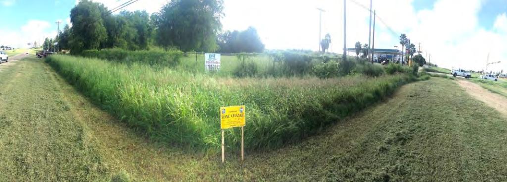
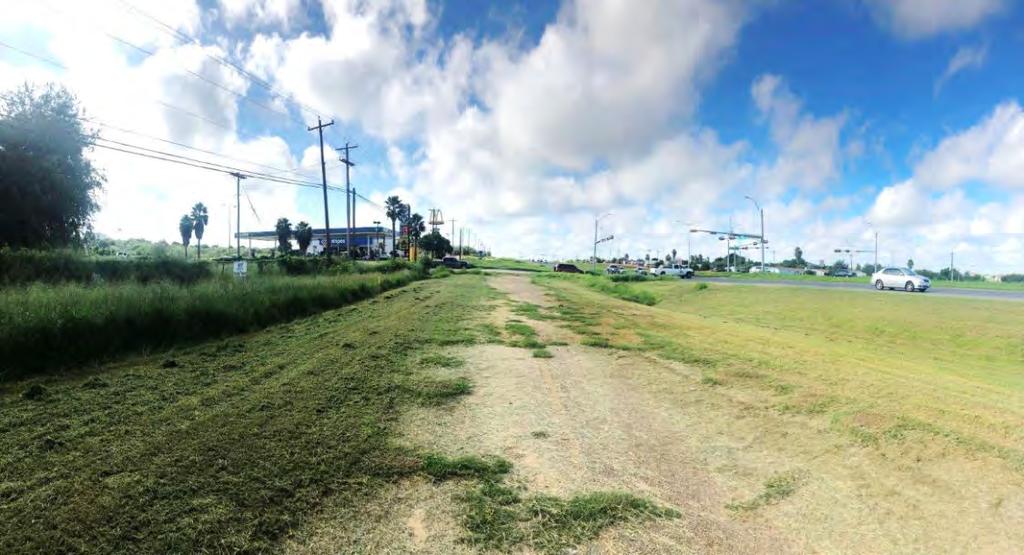
2 A. Amending the Zoning Ordinance (Map) of the City of Laredo by rezoning Lot 11, Block 1, Sierra Vista Unit IV-A, located at 4619 U.S. Highway 83, from R-1 (Single Family Residential District) to B-4 (Highway Commercial District). ZC District I B. Amending the Zoning Ordinance (Map) of the City of Laredo by rezoning Lots 7 and 8, Block 1764, Eastern Division, located at 2918 and 2920 Pine St., from B-1 (Limited Business District) to B-3 (Community Business District). ZC District II C. Amending the Zoning Ordinance (Map) of the City of Laredo by authorizing a Special Use Permit for a Restaurant Serving Alcohol on Lots 7, 8 and 9, Block 71, Eastern Division, located at 2020 Corpus Christi St. ZC District III D. Amending the Zoning Ordinance (Map) of the City of Laredo by rezoning approximately 5.66 acres, as further described by Metes and Bounds Exhibit A, located at East of Piedmont St. from RSM (Residential Suburban Multi-Family District) to R-l(Single Family Residential District). ZC District VI E. Amending the Zoning Ordinance (Map) of the City of Laredo by rezoning Lot 1, Block 1, Trinity Plaza Subdivision, located at 1815 Shiloh Dr., from B-1 (Limited Business District) to B-3 (Community Business District). ZC District VI F. Amending the Zoning Ordinance (Map) of the City of Laredo by rezoning Lot 4, Block 178, Western Division, located at 1007 San Dario Ave. from B-1 (Limited Business District) to B-4 (Highway Commercial District). ZC District VIII 7. REVIEW AND CONSIDERATION OF THE FOLLOWING MASTER PLAN:
3 A. Review and consideration of Cuatro Vientos East - Wright Ranch Subdivision Master Plan. The purpose of the update is to combine Phase ill & Phase XI. The intent is residential. District I- Cm. Rudy Gonzalez Jr. B. Review and consideration of Maxopress Properties Subdivision Master Plan. The intent is residential and commercial. District II - Cm. Vidal Rodriguez 8. CONSIDERATION OF THE FOLLOWING PRELIMINARY PLATS AND PRELIMINARY REPLATS: A. Preliminary consideration of the Plat of Cuatro Vientos East- Wright Ranch Subdivision Phase III. The intent is residential. District I - Rudy Gonzalez. Jr. B. Preliminary consideration of the Plat ofmaxopress Properties Subdivision Phase I. The intent is residential and commercial. District I- Cm. Vidal Rodriguez. 9. CONSIDERATION OF EXTENSION OF THE FOLLOWING FINAL PLATS APPROVALS: A. Consideration of an extension of the final plat approval of the Plat of Winfield Phase 9A & 9B. The intent is residential. District VI - Cm. Charlie San Miguel B. Consideration of an extension of the final plat approval of the Plat of Webb Industrial Park Phase III. The intent is industrial. District VII - George Altgelt 10. CONSIDERATION OF MODEL SUBDIVISION COMPLIANCE:

4 A. Consideration of the Model Subdivision Rule Compliance of the Plat of Lomas del Sur Subdivision Unit XV. The intent is residential. 11. ADJOURNMENT THIS NOTICE WAS POSTED AT THE MUNICIPAL GOVERNMENT OFFICES, 1110 HOUSTON STREET, LAREDO, TEXAS, AT A PLACE CONVENIENT AND READILY ACCESSIBLE TO THE PUBLIC AT ALL TIMES. SAID NOTICE WAS POSTED FRIDAY, OCTOBER 12, 2018 BY 6:00 P.M. (5_ DISABILITY ACCESS STATEMENT (5_ Persons with disabilities who plan to attend this meeting and who may need auxiliary aid or services are requested to contact Ana G. Villarreal, Planner II, at (956) , avillarre3@ci.laredo.tx.us, at least two working days prior to the meeting so that appropriate arrangements can be made. The accessible entrance and accessible parking spaces are located at City Hall, 1100 Victoria Ave. lnformacion en Espanol: Personas que planeen asistir a esta reunion y que requieran de servicios, auxiliares como: interpretes para personas sordas o con discapacidad auditiva, lectores de letra grande o en Braille, o un traductor del idioma espafiol, favor de comunicarse con Ana G. Villarreal, de! Departamento de Planificacion y Zonificacion de la Ciudad, 1120 San Bernardo Ave., al telefono (956) , o por correo electr6nico a, avillarre3@ci.laredo.tx.us, cinco dias habiles antes de la fecha en la cual se llevara a cabo dicha reunion, para que los arreglos apropiados puedan ser realizados. Materiales en espafiol 'n provistos mediante una petici6n, la cual debera ser efectuada tambien anti adamente. Vanessa Guerra Planning Department Jo City Secretary
5 CITY OF LAREDO PLANNING AND ZONING COMMISSION MINUTES OF THE PLANNING AND ZONING MEETING OF SEPTEMBER 20, 2018 The City of Laredo Planning and Zoning Commission convened in regular session open to the public at 6:00 p.m. on Thursday, September 20, 2018, in the City Council Chambers at City Hall, 1110 Houston Street, considered the following: Present: Absent: Staff: Others: Erasmo Villarreal Daniel Lopez Johnny Narvaez Jorge Dominguez Carlos Flores Joe Villarreal Jose Tellez Raul Ugalde Javier Compean Cynthia Collazo (City Manager s Office) Fernando Morales Ana Villarreal Alejandrina Sanchez Karina Castillo Ruben Dominguez (Fire Department) Rolando Ortiz Jerry Salinas Pat Murphy Frank Estrada Rodolfo Torres Judd Gilpin Gilberto Gonzalez Edward Ochoa 1. CALL TO ORDER Erasmo Villarreal, Chairman, called the meeting to order at 6:01 p.m. 2. ROLL CALL Fernando Morales, Planning Staff, called roll and verified a quorum existed. 3. PLEDGE OF ALLEGIANCE P & Meeting Minutes of September 20, 2018 Page 1
6 4. CONSIDER APPROVAL OF MINUTES OF: Regular Meeting of August 16, CITIZEN COMMENTS Citizens are required to fill out a witness card and submit it to a City Planner, or designee, no later than 5:45 p.m. and identify themselves at the microphone. Comments are limited to three (3) minutes per speaker. No more than three (3) persons will be allowed to speak on any side of an issue. Should there be more than three (3) people who wish to speak on a particular issue, they need to select not more than three (3) representatives to speak for them and the presiding officer may limit the public comments further in the interest of an orderly meeting. Speakers may not pass their minutes to any other speaker. Comments should be relevant to City business and delivered in a professional manner. No derogatory remarks will be permitted. 6. PUBLIC HEARING AND RECOMMENDATION OF AN ORDINANCE: A. Amending the Zoning Ordinance (Map) of the City of Laredo by rezoning Lot 10, Block 1260, Eastern Division, located at 2202 E. Plum St., from R-1 (Single Family Residential District) to R-O (Residential/ Office District). ZC District IV After reading the item and having no objections, the chairman opened the public hearing. Cm. Villarreal made a motion to close the public hearing and recommend approval for the proposed zone change. Second: Cm. Lopez In Favor: 6 Opposed: 0 Abstained: 0 Motion carried unanimously Cm. Ugalde joined the meeting at 6:04 p.m. B. Amending the Zoning Ordinance (Map) of the City of Laredo by repealing Ordinance No O-041 and authorizing a Special Use Permit for a restaurant serving alcohol on Lots 64 and 65, Block 2, North Creek Subdivision, located at 1010 E. Hillside Rd. ZC District V P & Meeting Minutes of September 20, 2018 Page 2
7 After reading the item and having no objections, the chairman opened the public hearing. Isis Monorres and Raquel Barrera spoke against the proposed Special Use Permit. Cm. Villarreal made a motion to close the public hearing and recommend denial for the proposed Special Use Permit subject to no outside music and extending the hours to 2:00 a.m. Second: Cm. Villarreal In Favor: 4 Opposed: 3 (Cm. Flores, Cm. Lopez, Cm. Ugalde) Abstained: 0 Motion carried C. Amending the Zoning Ordinance (Map) of the City of Laredo by rezoning approximately acres, as further described by Metes and Bounds Exhibit A, located at South of FM 1472 Rd.,(Mines Road) and West of Silver Mine Rd., from AG (Agricultural District) to M-1(Light Manufacturing District). ZC District VII After reading the item and having no objections, the chairman opened the public hearing. Fred Guerra, representing the applicant, spoke in favor of the item. Elizabeth Hill spoke against the proposed zone change. Cm. Dominguez made a motion to close the public hearing and recommend approval for the proposed zone change. Second: Cm. Villarreal In Favor: 6 Opposed: 0 Abstained: 1 (Cm. Flores) Motion carried Cm. Lopez left the meeting at 6:36 p.m. D. Amending the Zoning Ordinance (Map) of the City of Laredo by rezoning approximately acres, as further described by Metes and Bounds Exhibit A, located South of FM 1472 Rd., and North of Vidal Cantu Rd., from AG (Agricultural District) to M-1(Light Manufacturing District). P & Meeting Minutes of September 20, 2018 Page 3
8 ZC District VII After reading the item and having no objections, the chairman opened the public hearing. Judd Gilpin, Gilpin Engineering, spoke in favor of the item. Cm. Ugalde made a motion to close the public hearing and recommend approval for the proposed zone change. Second: Cm. Dominguez In Favor: 6 Opposed: 0 Abstained: 0 Motion carried unanimously E. Amending the Zoning Ordinance (Map) of the City of Laredo by rezoning approximately acres, as further described by Metes and Bounds Exhibit A, located Northeast of FM 1472 Rd., and North of World Trade Center Loop, from AG (Agricultural District) to M-1(Light Manufacturing District). ZC District VII After reading the item and having no objections, the chairman opened the public hearing. Judd Gilpin, Gilpin Engineering, spoke in favor of the item. Cm. Ugalde made a motion to close the public hearing and recommend approval for the proposed zone change. Second: Cm. Villarreal In Favor: 6 Opposed: 0 Abstained: 0 Motion carried unanimously 7. REVIEW AND CONSIDERATION OF THE FOLLOWING MASTER PLAN: A. Review and consideration of the revision of Cuatro Vientos Sur Subdivision Master Plan. The intent is residential and commercial. This revision includes changes in land use in Phases X and an addition of Phase XII. District I- Cm. Rudy Gonzales, Jr. Wayne Nance, Porras-Nance Engineering, concurred with all comments except for Traffic comment #1 and asked to remove it. He stated he had met with Traffic Department regarding the comment and Traffic was okay with deleting the comment. P & Meeting Minutes of September 20, 2018 Page 4
9 Planning Staff concurred to remove Traffic Department comment #1. Cm. Dominguez made a motion to approve the item subject to removing comment #1 for Traffic Department. Planning: 1. Submit master plan revision to City of Laredo Building Department GIS Division within 10 days of commission approval in a geo-referenced CAD file in accordance to Section 2-3.2(a) 4 of the City of Laredo Subdivision Ordinance. 2. There is a land use change in Phase III (original master plan) from multifamily to revised master plan Phase VI single family residential units indicates a substantial alteration and this master plan will be considered the first in a new series of permits (Chapter 245 Texas Local Government Code). 3. All improvements as Per Subdivision Ordinance. Engineering: No comments submitted. Fire: No comments submitted. Environmental: No comments submitted. Water & Utilities: 1. For Phase VIII, the development is commercial and is fronting the Ejido Ave. where the engineer has extended the 12" water line to Bianka Ln. Traffic Safety: 1. The street Vientos is too close but not align to the street on the north (Amelia). 2. Some streets will need traffic calming devices. Parks & Leisure: 1. Parkland has been dedicated to the City of Laredo, developer needs to pay NPIF for all additional family lots added to the Master Plan. WEBB County App: No comments submitted. AEP Engineers: No comments submitted. U.I.S.D.: No comments submitted. L.I.S.D.: No comments submitted. P & Meeting Minutes of September 20, 2018 Page 5
10 AT&T: No comments submitted. NOTICE TO THE DEVELOPER: Planning: 1. Only the utility easements within the plat boundaries are subject to change prior to plat recordation, due to revisions by the utility companies. 2. All comments set forth herein are preliminary comments and not an exhaustive list. Additional comments may be added prior to final plat approval. Second: Cm. Dominguez In Favor: 6 Opposed: 0 Abstained: 0 Motion carried unanimously B. Review and consideration of the update of Lomas Del Sur Subdivision Master Plan. The intent is residential and commercial. This update includes changes in Phases XII and XIII. District I- Cm. Rudy Gonzalez, Jr. Frank Estrada, Sherfey Engineering, concurred with all comments. Cm. Ugalde made a motion to approve the item subject to all comments. Planning: 1. Submit master plan revision to City of Laredo Building Department GIS Division within 10 days of commission approval in a geo-referenced CAD file in accordance to Section 2-3.2(a) 4 of the City of Laredo Subdivision Ordinance. 2. All improvements as Per Subdivision Ordinance. Engineering: No comments submitted. Fire: No comments submitted. Environmental: No comments submitted. Water & Utilities: 1. The engineer has to update the Water Master Plan. In the original M.P. Guayamas Rd. was not included in Phase XII. 2. The layout of the sanitary sewer Master Plan is very different to what the water Master Plan shows. The engineer has to update Sanitary Sewer Master Plan and send a copy to LWUD for review. P & Meeting Minutes of September 20, 2018 Page 6
11 Traffic Safety: 1. Some streets will need calming devices. 2. Some streets don't intersect and are too close. 3. Name streets. 4. Some streets have sight distance. Parks & Leisure: 1. Developer needs to pay NPIF for all additional family lots added to the Master Plan, Parkland required is 3.06 acres, Parkland Site Reliance Approval is for 3.25 acres. WEBB County App: No comments submitted. AEP Engineers: No comments submitted. U.I.S.D.: No comments submitted. L.I.S.D.: No comments submitted. AT&T: No comments submitted. NOTICE TO THE DEVELOPER: Planning: 1. Only the utility easements within the plat boundaries are subject to change prior to plat recordation, due to revisions by the utility companies. Second: Cm. Narvaez In Favor: 6 Opposed: 0 Abstained: 0 Motion carried unanimously 8. CONSIDERATION OF THE FOLLOWING PRELIMINARY PLATS AND PRELIMINARY REPLATS: A. Preliminary consideration for the Plat of Cuatro Vientos Sur Subdivision Phase X. The intent is residential. District 1 - Cm. Rudy Gonzalez, Jr. Wayne Nance, Porras-Nance Engineering, concurred with all comments except for comment # 1 for Traffic Department. He asked to remove the comment. Planning Staff concurred to remove Traffic Department comment #1. P & Meeting Minutes of September 20, 2018 Page 7
12 Cm. Dominguez made a motion to approve the item subject to removing comment #1 for Traffic Department to approval of the variance on the building setbacks within the 4 lots of the cul de sac and on the plat note to recognize the garage structure to be a 20 ft building setback. Planning: 1. Submit a written notice of the developer s intention to place front of lot utilities. 2. Revise "Attestment of Planning Commission Approval" signature block to "Vanessa Guerra, Planning Department." 3. Revise plat note #6 by removing Lot 1, Block 6, or clarify where Lot 1, Block 6 is located. 4. A change of zoning will be required for the proposed size of lots. 5. All improvements as per Subdivision Ordinance. Engineering: No comments submitted. Fire: No comments submitted. Environmental: No comments submitted. Water & Utilities: 1. The water lines for Phase X will be connected to the existing 16" water line along Bianka Ln. 2. For the sanitary sewer it has to be directed to the M.H. at the intersection of Bianka Ln. and Vientos Rd. Traffic Safety: 1. Amelia is not aligned to Vientos Rd. and is too close. 2. Some streets might need calming devices. Parks & Leisure: No comments submitted. WEBB County App: No comments submitted. AEP Engineers: No comments submitted. U.I.S.D.: No comments submitted. L.I.S.D.: No comments submitted. AT&T: No comments submitted. NOTICE TO THE DEVELOPER: P & Meeting Minutes of September 20, 2018 Page 8
13 Planning: 1. Only the utility easements within the plat boundaries are subject to change prior to plat recordation, due to revisions by the utility companies. 2. All comments set forth herein are preliminary comments and not an exhaustive list. Additional comments may be added prior to final plat approval. Second: Cm. Villarreal In Favor: 6 Opposed: 0 Abstained: 0 Motion carried unanimously B. Preliminary consideration of the Replat of Lot 6, Block 2, Pinto Valle Industrial Park Phase 1 into Lot 6A, Block 2, Pinto Valle Industrial Park Phase 1. The intent is industrial. The purpose of this replat is to add an access and utility easement for the Plat of PG Pinto Valle Industrial District VII- Cm. George J. Altgelt. Daniel Gomez, P.E., concurred with all comments. Cm. Ugalde made a motion to approve the item subject to all comments. Planning: 1. Submit a written notice of the developer s intention to place front of lot utilities. 2. Revise "Attestment of Planning Commission Approval" signature block to "Vanessa Guerra, Planning Department." 3. Revise plat note #6 by removing Lot 1, Block 6, or clarify where Lot 1, Block 6 is located. 4. A change of zoning will be required for the proposed size of lots. 5. All improvements as per Subdivision Ordinance. Engineering: No comments submitted. Fire: No comments submitted. Environmental: No comments submitted. Water & Utilities: 1. The water lines for Phase X will be connected to the existing 16" water line along Bianka Ln. 2. For the sanitary sewer it has to be directed to the M.H. at the intersection of Bianka Ln. and Vientos Rd. Traffic Safety: P & Meeting Minutes of September 20, 2018 Page 9
14 1. Amelia is not aligned to Vientos Rd. and is too close. 2. Some streets might need calming devices. Parks & Leisure: No comments submitted. WEBB County App: No comments submitted. AEP Engineers: No comments submitted. U.I.S.D.: No comments submitted. L.I.S.D.: No comments submitted. AT&T: No comments submitted. NOTICE TO THE DEVELOPER: Planning: 1. Only the utility easements within the plat boundaries are subject to change prior to plat recordation, due to revisions by the utility companies. 2. All comments set forth herein are preliminary comments and not an exhaustive list. Additional comments may be added prior to final plat approval. Second: Cm. Villarreal In Favor: 6 Opposed: 0 Abstained: 0 Motion carried unanimously C. Preliminary consideration of the Plat of PG Pinto Valle Industrial Park. The intent is industirial. District VII- Cm. George J. Altgelt. Daniel Gomez, P.E., concurred with all comments. Cm. Ugalde made a motion to approve the item subject to all comments. Planning: 1. Revise the boundaries of the plat to not include Lots in the southern part of the plat. 2. Revise legal description. 3. Remove one of the Point of Beginings that is shown. Only leave the correct one. 4. Provide plat note stating that there are off-site utilies and access easements. 5. Revise city limit lines to show the current city boundary. 6. Revise vicinity map on page 2. P & Meeting Minutes of September 20, 2018 Page 10
15 7. Identify Utility Easement that is located along FM Revise "Attestment of Planning Commission Approval" signature block to "Vanessa Guerra, Planning Department." Engineering: No comments submitted. Fire: No comments submitted. Environmental: No comments submitted. Water & Utilities: No comments submitted. Traffic Safety: No comments submitted. Parks & Leisure: No comments submitted. WEBB County App: No comments submitted. AEP Engineers: No comments submitted. U.I.S.D.: No comments submitted. L.I.S.D.: No comments submitted. AT&T: No comments submitted. NOTICE TO THE DEVELOPER: Planning: 1. Only the utility easements within the plat boundaries are subject to change prior to plat recordation, due to revisions by the utility companies. 2. All comments set forth herein are preliminary comments and not an exhaustive list. Additional comments may be added prior to final plat approval. Second: Cm. Dominguez In Favor: 6 Opposed: 0 Abstained: 0 Motion carried unanimously 9. CONSIDERATION OF THE FOLLOWING FINAL PLATS AND FINAL REPLATS: A. Final consideration of the Replat of Lot 9, Block 3, Santa Rita Subdivision into Lots 9-A and 9-B, Block 3, Santa Rita Subdivision. The intent is residential. The P & Meeting Minutes of September 20, 2018 Page 11
16 purpose of this replat is to create two (2) smaller lots from one (1) larger lot. District III - Alejandro "Alex" Perez. Cm. Ugalde made a motion to approve the item. Second: Cm. Dominguez In Favor: 6 Opposed: 0 Abstained: 0 Motion carried unanimously B. Final consideration of the Plat of Lomas Del Sur Subdivision Phase XII. The intent is residential. District I- Cm. Rudy Gonzalez, Jr. Cm. Ugalde made a motion to combine items 9-B thru 9-G, and 10-A together. Second: Cm. Dominguez In Favor: 6 Opposed: 0 Abstained: 0 Motion carried unanimously Cm. Ugalde made a motion to approve items 9-B thru 9-G, and 10-A together. C. Final reconsideration of the Plat of Las Fincas Subdivision Phase I. The intent isresidential. District II- Cm. Vidal Rodriguez D. Final consideration of the Plat of Mars Warrior Properties. The intent is commercial. District II - Cm. Vidal Rodriguez F. Final consideration of the Plat of Lot 1, Block 1, Alexander Crossing Plaza. The intent is commercial. District V - Cm. Norma "Nelly" Vielma. G. Final consideration of an Amended Plat for Lots 1A & 2A, Block 2 Monaco Subdivision. The intent is commercial. District VI- Cm. Charlie San Miguel H. Final consideration of the Plat of Villas San Agustin Unit 6. The intent is residential. District VII- Cm. George Altgelt 10. CONSIDERATION OF MODEL SUBDIVISION COMPLIANCE: P & Meeting Minutes of September 20, 2018 Page 12
17 A. Consideration of the Model Subdivision Rule Compliance for the Plat of Sunset Heights Subdivision. The intent is residential. District VI- Cm. Charlie San Miguel Second: Cm. Dominguez In Favor: 6 Opposed: 0 Abstained: 0 Motion carried unanimously XIII. Public hearing and recommendation of an ordinance requiring the City of Laredo's participation in the development of neighborhood associations. Cm. Villarreal left the meeting at 6:53 p.m. Karina Castillo, Planning Staff, stated Arturo Garcia from Community Development added a definition of the designated permit official. Cm. Flores proposed a statement which states that membership is not required and is on a voluntary basis open to all. Cm. Dominguez made a motion to close the public hearing and recommend approval for the proposed ordinance amendment. Second: Cm. Ugalde In Favor: 5 Opposed: 0 Abstained: 0 Motion carried unanimously 11. ADJOURNMENT Cm. Dominguez made a motion to adjourn the meeting at 6:55 p.m. Second: Cm. Ugalde In Favor: 5 Opposed: 0 Abstained: 0 Motion carried unanimously Vanessa Guerra, Interim Director, Planning & Zoning Department Erasmo Villarreal, Chairman, Planning & Zoning Commission P & Meeting Minutes of September 20, 2018 Page 13
18 CITY OF LAREDO PLANNING AND ZONING COMMISSION MINUTES OF THE PLANNING AND ZONING MEETING OF OCTOBER 4, 2018 The City of Laredo Planning and Zoning Commission convened in regular session open to the public at 6:00 p.m. on Thursday, October 4, 2018, in the City Council Chambers at City Hall, 1110 Houston Street, considered the following: Present: Absent: Staff: Others: Erasmo Villarreal Jose Tellez Javier Compean Raul Ugalde Johnny Narvaez Carlos Flores (excused) Joe Villarreal Daniel Lopez (excused) Jorge Dominguez (excused) Vanessa Guerra Fernando Morales Ana Villarreal Karina Castillo Ruben Dominguez (Fire Department) Sinai Castro (Traffic Safety Department) Alec Martinez (Traffic Safety Department) Frank Estrada 1. CALL TO ORDER Cm. Villarreal called the meeting to order at 6:04 p.m. 2. ROLL CALL Cm. Ugalde made a motion to excuse Cm. Flores, Cm. Dominguez and Cm. Lopez Second: Cm. Narvaez In Favor: 5 Opposed: 0 Abstained: 0 Motion carried unanimously 3. PLEDGE OF ALLEGIANCE P & Z Minutes of October 4, 2018 Page 1
19 4. CONSIDER APPROVAL OF MINUTES OF: Regular Meeting of September 6, 2018 Cm. Narvaez made a motion to approve the minutes of September 6, Second: Cm. Compean In Favor: 5 Opposed: 0 Abstained: 0 Motion carried unanimously 5. CITIZEN COMMENTS Citizens are required to fill out a witness card and submit it to a City Planner, or designee, no later than 5:45 p.m. and identify themselves at the microphone. Comments are limited to three (3) minutes per speaker. No more than three (3) persons will be allowed to speak on any side of an issue. Should there be more than three (3) people who wish to speak on a particular issue, they need to select not more than three (3) representatives to speak for them and the presiding officer may limit the public comments further in the interest of an orderly meeting. Speakers may not pass their minutes to any other speaker. Comments should be relevant to City business and delivered in a professional manner. No derogatory remarks will be permitted. 6. REVIEW AND CONSIDERATION OF THE FOLLOWING MASTER PLAN: A. Review and consideration of Phoenix Village Master Plan. The intent is residential. District II - Cm. Vidal Rodriguez Frank Estrada, Sherfey Engineering, concurred with Staff comments. Cm. Ugalde made a motion to approve the item subject to the following comments and additional comments submitted by Water & Utilities. Planning: 1. Submit master plan revision to City of Laredo Building Department GIS Division within 10 days in a geo-referenced CAD file in accordance to Section 2-3.2(a) 4 of the City of Laredo Subdivision Ordinance. 2. Provide and label current City Limits on master plan. 3. Provide street names or street name designations (Example: Street A, Street B ) 4. Label Lot 45, Block 2 as Drainage Easement. 5. All improvements as Per Subdivision Ordinance. Engineering: No comments submitted. Fire: No comments submitted. P & Z Minutes of October 4, 2018 Page 2
20 Environmental: No comments submitted. Water & Utilities: No comments submitted. Traffic Safety: 1. Missing street names. 2. There is sight distance at several intersections. 3. Streets need to intersect at a right angle for a minimum of 100 ft. 4. Streets intersecting are too close. 5. Some streets will need calming devices. 6. Fix the street jogs at Phase 6 and Phase 11. Parks & Leisure: No comments submitted. WEBB County App: No comments submitted. AEP Engineers: No comments submitted. U.I.S.D.: No comments submitted. L.I.S.D.: No comments submitted. AT&T.: No comments submitted. NOTICE TO THE DEVELOPER: Planning: 1. Only the utility easements within the plat boundaries are subject to change prior to plat recordation, due to revisions by the utility companies. Water & Utilities: 1. The original Master Plan was showing only Six Phases and the Water and Sanitary Sewer LUE s acquired by the developer were 255 for water and 401 for sanitary sewer. At this point and time there are 5 Subdivisions approve and the remaining quantities for LUE s are 71 for water and 217 for sewer. Second: Cm. Narvaez In Favor: 5 Opposed: 0 Abstained: 0 Motion carried unanimously 7. CONSIDERATION OF THE FOLLOWING PRELIMINARY PLATS AND PRELIMINARY REPLATS: P & Z Minutes of October 4, 2018 Page 3
21 A. Preliminary consideration of C-44-A Los Botines Plat. The intent is residential. Fred Guerra, Guerra Engineering, concurred with all comments via . Cm. Narvaez made a motion to approve the item subject to the following comments and additional comments submitted by Water & Utilities. Planning: 1. Provide Lot and Block number. 2. Show city limits on vicinity map. 3. Provide better vicinity map. 4. Show boundary of ROW. 5. Revise Attestment of Planning Commission Approval from "Nathan Bratton, Planning Director" to "Vanessa Guerra, Planning Department." 6. Show correct property owner/developer. 7. All improvements as Per Subdivision Ordinance. Engineering: No comments submitted. Fire: 1. Need improvement survey. 2. No fire hydrant available. 3. Location Map not clear as per exact location. 4. Need more information on plat to determine exact location on site. Environmental: No comments submitted. Water & Utilities: No comments submitted. Traffic Safety: No comments submitted. Parks & Leisure: No comments submitted. WEBB County App: 1. Owner is Melchor Macias, with Warranty Deed in Volume 4478 Page 211 and plat is showing the same volume and page to M&M Builders LLC. AEP Engineers: No comments submitted. U.I.S.D.: No comments submitted. L.I.S.D.: No comments submitted. AT&T: No comments submitted. P & Z Minutes of October 4, 2018 Page 4
22 NOTICE TO THE DEVELOPER: Planning: 1. Only the utility easements within the plat boundaries are subject to change prior to plat recordation, due to revisions by the utility companies. 2. All comments set forth herein are preliminary comments and not an exhaustive list. Additional comments may be added prior to final plat approval. Water & Utilities: 1. For this development the engineer has to provide along with the Water and Sewer Master Plans the water and sanitary sewer plans and profiles with all the information related to the design for water and sewer utilities. Second: Cm. Ugalde In Favor: 5 Opposed: 0 Abstained: 0 Motion carried unanimously 8. RECONSIDERATION OF THE FOLLOWING PRELIMINARY PLATS AND PRELIMINARY REPLATS: A. Preliminary reconsideration of the Plat of Phoenix Village Subdivision Phase VI. The intent is residential. District II - Cm. Vidal Rodriguez Frank Estrada, Sherfey Engineering, concurred with Staff comments. Cm. Ugalde made a motion to approve the item subject to the following comments and additional comments submitted by Water & Utilities. Planning: 1. Provide plat note with X, Y coordinates for point of beginning and point of commencement. 2. Provide street names to subdivision plat. 3. Provide proposed street names to Planning Department for review. 4. Provide total number of lots on plat. 5. Label Lot 46, Block 1 as Open Space/Detention Pond as per Master Plan. 6. Label the lot between Lot 44 and Lot 45, Block 2 as Lot 45, Block 2/drainage easement as per Master Plan. 7. Park Improvement Fees will need to be paid prior to recordation. 8. Revise Attestment of Planning Commission Approval from "Nathan Bratton, Planning Director" to "Vanessa Guerra, Planning Department." 9. All improvements as Per Subdivision Ordinance. P & Z Minutes of October 4, 2018 Page 5
23 Engineering: No comments submitted. Fire: 1. No street name on northernmost intersection. 2. No street name on Street "A." Environmental: No comments submitted. Water & Utilities: No comments submitted. Traffic Safety: 1. Some streets will need calming devices. Parks & Leisure: No comments submitted. WEBB County App: No comments submitted. AEP Engineers: No comments submitted. U.I.S.D.: No comments submitted. L.I.S.D.: No comments submitted. AT&T: No comments submitted. NOTICE TO THE DEVELOPER: Planning: 1. Only the utility easements within the plat boundaries are subject to change prior to plat recordation, due to revisions by the utility companies. 2. All comments set forth herein are preliminary comments and not an exhaustive list. Additional comments may be added prior to final plat approval. Water & Utilities: 1. For C-44-A Los Botines Plat the City does not have water or sanitary sewer at Los Botines, and the project is outside City Limits. They can plot with the County only. Second: Cm. Compean In Favor: 5 Opposed: 0 Abstained: 0 Motion carried unanimously P & Z Minutes of October 4, 2018 Page 6
24 9. CONSIDERATION OF THE FOLLOWING FINAL PLATS AND FINAL REPLATS: A. Final consideration of the Plat of Lots 2 and 3, Block 2, Alexander Crossing Plaza. The intent is commercial. District V - Cm. Norma "Nelly" Vielma Cm. Ugalde made a motion to approve the item. Second: Cm. Compean In Favor: 5 Opposed: 0 Abstained: 0 Motion carried unanimously 10. CONSIDERATION OF MODEL SUBDIVISION COMPLIANCE: A. Consideration of the Model Subdivision Rule Compliance for the Plat of Kimberly Subdivision at Plantation Phase II. The intent is residential. District VI- Cm. Charlie San Miguel Cm. Ugalde made a motion to approve the item. Second: Cm. Compean In Favor: 5 Opposed: 0 Abstained: 0 Motion carried unanimously 11. ADJOURNMENT Cm. Tellez made a motion to adjourn the meeting at 6:12 p.m. Second: Cm. Ugalde In Favor: 5 Opposed: 0 Abstained: 0 Motion carried unanimously Vanessa Guerra Planning Department Erasmo A. Villarreal Chairman P & Z Minutes of October 4, 2018 Page 7
25 Planning and Zoning Commission- Regular 6. A. Meeting Date: 10/18/2018 Staff Source: Cynthia Collazo, Deputy City Manager Staff Source: Ana Villareal, Planner II Initiated by: Mex Industrial Supply Corp, Owner; David Ruiz, Applicant Prior Action: None SUBJECT: Amending the Zoning Ordinance (Map) of the City of Laredo by rezoning Lot 11, Block 1, Sierra Vista Unit IV-A, located at 4619 U.S. Highway 83, from R-1 (Single Family Residential District) to B-4 (Highway Commercial District). ZC District I BACKGROUND: Council District: I The Honorable Rudy Gonzalez, Jr. Proposed use: Commercial Billboard. Site: The site is currently raw undeveloped land. Surrounding land uses: North of the property is the Church Iglesia Cristiana Viento de Dios. South of the property, across Sierra Vista Blvd. is a gas station. East of the site are vacant lots, a storage unit and single family residential uses. Comprehensive Plan: The Future Land Use Map recognizes this area as Low Density Residential. Transportation Plan: The Long Range Thoroughfare Plan has designated the U.S. Highway 83 as an Expressway and Sierra Vista Blvd. as a Minor Arterial. Letters sent to surrounding property owners: 9 In Favor:0 Opposed: 0 STAFF COMMENTS:
26 Staff does not supportthe proposed zone change because for the following reason: 1. The proposed B-4 District is not in conformance with the Comprehensive Plan s designation of this area as Low Density Residential (Zoning Group includes R-1, R-1MH, R-1A, R-1B, R-S, B-1R AND R-O with exceptions). However, the property meets the following requirements: 1. The property complies with the minimum B-4 lot size of 10,000 s.f. (The property is approximately 44,066 s.f.) 2. The proposed B-4 (Highway Commercial District) is to be located along an Expressway. * Uses allowed in a B-4 District include but are not limited to the following: Bar, Night Club, Cantina, and Saloon Alcoholic Rehabilitation Facility Alcoholic Beverage Storage and Distribution Heavy Machinery Sales/Display (Outdoor) Commercial Parking Lot (Trucks/Heavy Equip.) Major Appliances Sales (Outdoor) Auto Impound Yard (Public/Private) Waste Recycle Collection Refer to the attached Section Permitted Uses for a list of allowed uses in B-4 Zoning District. P&Z RECOMMENDATION: STAFF RECOMMENDATION: Staff does not support the proposed zone change. IMPACT ANALYSIS B-4 (Highway Commercial District): The purpose of the B-4 District (Highway Commercial District) is to provide for those businesses and services serving a regional area which are to be located primarily along principal (major) arterial streets or the freeway, as classified in the Transportation Plan of the City of Laredo. It is intended for this zoning classification to exist primarily along principal arterial streets or the freeway and to impose site development regulations to ensure adequate access of all uses within this classification. Is this change contrary to the established land use pattern? Yes. The established land use pattern on this section of U.S. Highway 83 is light commercial and residential.
27 Would this change create an isolated zoning district unrelated to surrounding districts? Yes. The only B-4 zoning designation is to the west of the property, across U.S. Highway 83. Will the change adversely influence living conditions in the neighborhood? Yes. The proposed use may introduce more noise and heavier traffic into the residential neighborhood. Are there substantial reasons why the property cannot be used in accordance with existing zoning? Yes. The existing zoning designation (R-1 Single Family Residential District) does not allow for the proposed use. Aerial Map Zoning Map Location Map District Map Future Land Use Map Land Use Equivalents Chart Survey Pictures Attachments


28 B : 3 0 L : 1 B : L : U N P L A T T E D B : 1 L : B : 1 L : 1 2 B : L : U N P L A T T E D B : 1 L : B : 1 L : 4 W R I G H T W A Y B : 1 B : 1 B : 1 B : 1 L : 1 L : 2 L : 3 L : B : 1 B : 1 L : 1 7 L : B : 1 L : 1 5 L A M R I C K C I R B : 1 L : B : 1 B : 1 B : 1 B L : 4 : 1 L : 5 L : 6 L : B : 1 L : 3 B : 2 9 L : S A N T A M A R T H A B L V D U S H I G H W A Y B : 1 L : B : 1 L : B : 1 L : 9 S I E R R A V I S T A B L V D B : L : B : L : U N P L A T T E D M O O N L N B : 5 L : B : 1 L : B : 1 L : B : 1 L : 1!I B : 1 L : B : 1 L : 2 AERIAL MAP 1 inch = 125 feet ZC COUNCIL DISTRICT S US HIGHWAY 83 APPLICATION FOR R1 (SINGLE FAMILY RESIDENTIAL DISTRICT) -> B4 (HIGHWAY COMMERCIAL DISTRICT)


29 4525 L: L: L: L: 2 M L: 1 L: UNPLATTED L: UNPLATTED W R I G H T W A Y 2464 L: L: L: 1 C O L O N I A L O O P 2460 L: L: L: L: L: L: L: L: L: L: L: L: L: 33 L: L I R I O S D R 629 L: B L: 25A 627-A L: 25B 625-B L: 25C!I 625-A L: 25D 621 L: L: L: 1 S A N TA M A R T H A B L V D 654 L: L: B L: 25H 628-A L: 25G 626-B L: 25F 626-A L: 25E 624 L: 11 H O R T E N S I A L N ZONING MAP 1 inch = 167 feet 641 L: L: L: L: L: L: L: 24 B L: 23 R-1MH 16 U S H I G H W A Y 8 3 ZC COUNCIL DISTRICT S US HIGHWAY 83 AG 4701 L: L: 2 L: UNPLATTED 4605 L: L: L: 13 1 B-3 L: 10 L: UNPLATTED 4510 L: L: L: L: L: L: L: L: L: 3 L A M R I C K C I R 4609 L: 2 B-3 SUZD 4613 L: L: L: L: 3 97-O-326 S I E R R A V I S T A B L V D 101 L: L: L: L: 15 R-1 APPLICATION FOR R1 (SINGLE FAMILY RESIDENTIAL DISTRICT) -> B4 (HIGHWAY COMMERCIAL DISTRICT) L: L: L: L: L: L: L: L: L: L: UNPLATTED L O S F R E S N O S 114 L: 13 M O O N L N 102 L: 1 L O O P 104 L: L: 3 C E N I S O L O O P 102 L: L: L: L: L: L: L: L: L: L: L: L: 3
30 Ejido Wormser CR 312 LOMAS DEL SUR BLVD MASTERSON LA PITAMANGANA LA PITAMANGANA 83 UV 20 SIERRA VISTA SIE RRA VI STA MACHIN UV 20 UV 20!I LOCATION MAP 1 inch = 2,083 feet ZC COUNCIL DISTRICT S US HIGHWAY 83 APPLICATION FOR R1 (SINGLE FAMILY RESIDENTIAL DISTRICT) -> B4 (HIGHWAY COMMERCIAL DISTRICT)
31 S A N T A M A R T H A B L V D U S H I G H W A Y S I E R R A V I S T A B L V D W R I G H T W A Y L A M R I C K C I R !I DIMENSIONS MAP 1 inch = 125 feet ZC COUNCIL DISTRICT S US HIGHWAY 83 APPLICATION FOR R1 (SINGLE FAMILY RESIDENTIAL DISTRICT) -> B4 (HIGHWAY COMMERCIAL DISTRICT)
32 Light Industrial W R I G H T W A Y C O L O N I A L O O P Mixed-Use Center L A M R I C K C I R EXPRESSWAY Low Density Residential L I R I O S D R!I S A N TA M A R T H A B L V D FUTURE LANDUSE MAP 1 inch = 167 feet Medium Density Residential U S H I G H W A Y 8 3 ZC COUNCIL DISTRICT S US HIGHWAY 83 S I E R R A V I S TA B L V D MINOR ARTERIAL Neighborhood Mixed-Use APPLICATION FOR R1 (SINGLE FAMILY RESIDENTIAL DISTRICT) -> B4 (HIGHWAY COMMERCIAL DISTRICT) L O S F R E S N O S M O O N L N L O O P C E N I S O L O O P
33 Land Use Equivalents Chart New Land Use Types Current Zoning Groups Agricultural / Rural AG Low Density Residential R-1,R-1-MH, R-1A, R-1B, R-S, B-1R, and R-O with exceptions * Medium Density Residential R-1, R-O, R-2, B-1R, R1-B, Small format market High Density Residential R-3, R-2, B-1R, B-1, R-O Neighborhood Mixed-Use ALL EXCEPT M-1, M-2, B-4, AH, AN, FH, OG, FiH Mixed-Use Center ALL EXCEPT, M-1, M-2, AH, AN, FH, OG. B4 allowed with exceptions** Downtown Mixed-Use CBD, R-1, R-2, R-3, R-1B, R-1A, R-O, AE Institutional CF, MF Light Industrial M-1, B-4, B-3 Heavy Industrial M-1, M-2, B-4, B-3, FiH Transportation AH, AN Parks * RO within a Low Density Residential is allowed with the exception of restaurants. ** Land uses allowed under a B4 are allowed with the exception of the following uses***: Farms, General (Crops & Livestock) Farms, General (Livestock/Ranch) Bulk Grain And/Or Feed Storage Veterinarian (Outdoor Animal Confinement) Stables (Private, Principle Use) Stables (Private, Accessory Use) Stables (Commercial) Auto Wrecker Service Inoperable Vehicle Holding Yard Jail Halfway House Scrap/Waste Recycle Collection Zoo Horse Training Facility Amusement Redemption Machine Establishment Auto Impound Yards Auto Salvage Yards Transit and Maintenance Vehicle Equipment Facility Collection Container The intent of this table is to provide a transitional language between the uses recommended within the vision of this plan and the current land development uses which are organized through the use of zones. When the city s land development code is revised and adopted according to this plan, this table will no longer be necessary. This table should not be used to directly translate the current zoning to new land development code revisions. City staff should use discretion and best planning practices if using this table as guide in any approval process. ***Note: exceptions only apply to the extent that they do not contradict any other ordinances such as the Urban Agriculture Ordinance, as an example VIVA LAREDO
34 The city has no water features; only Casa Blanca. North Laredo Central Park could be turned into a river walk with an urban recreational lake surrounded by businesses. Create incentives for job creation, economic development, and alternative land development options (higher and lower density). Land Uses Place types and neighborhoods are made up by different land uses in the future land use map. Specified land uses however, are not meant to equate to singleuse zoning areas. Rather a land use type in the future land use map describes the overall character of a neighborhood. Neighborhoods are generally made up of residential and mixed-use designations: Low-Density Residential describes a neighborhood whose character is primarily defined by single-family homes. A diverse range of lot sizes and unit types is encouraged, along with an interconnected network of blocks, streets and public spaces. Denser housing types such as duplexes, fourplexes and small apartment buildings should be designed to fit into the character of a single-family residential neighborhood. Thoughtfully designed small office, retail or mixed-use buildings can also be built at key intersections to provide neighborhood amenities. Civic buildings should also respect the character of a primarily residential neighborhood, but can also be used as landmarks. Medium-Density Residential describes a neighborhood that is primarily residential in character, but includes a full range of range of residential building types. These include singlefamily homes in small and medium sized lots, attached rowhouses and apartment buildings. Thoughtfully designed small office, retail or mixed-use buildings can also be built at key intersections to provide neighborhood amenities. Civic buildings should also respect the character of a primarily residential neighborhood, but can also be used as landmarks. Low Density Residential Medium Density Residential High Density Residential LAND USE PATTERNS 1.15
35 High-Density Residential describes a neighborhood whose character is primarily defined by multi-family residential building types, but can also include single family homes in small lots and neighborhood-serving businesses. A diverse range of housing types is encouraged, including attached rowhouses, small and large apartment buildings, courtyard buildings and small mixeduse buildings. Small office, retail or mixed-use buildings can also be built at key intersections to provide neighborhood amenities. Civic buildings should be sited to provide landmarks to the neighborhood. Neighborhood Mixed-Use Neighborhood Mixed-Use describes a neighborhood-serving mixed-use district that includes multistory, mixed-use buildings with commercial, office and residential uses. Multifamily residential buildings are also appropriate as a transition between main street shopping areas and primarily residential neighborhoods. Mixed-Use Center describes a mixed-use center that includes multistory, mixed-use buildings with commercial, office and residential uses. Regional or neighborhood oriented shopping areas are encouraged as a primary feature. Multi-family residential buildings are also appropriate as a transition between main street shopping areas and primarily residential neighborhoods. Downtown Mixed-Use describes the most intense urban development in the City of Laredo. Reserved primarily for downtown Laredo, it includes multi-story mixed-use buildings with commercial, office and residential uses. Multifamily residential buildings are also appropriate as a transition between the downtown and primarily residential neighborhoods. The addition of residential uses on the upper floors of downtown buildings is encouraged as a priority for downtown revitalization. Mixed-Use Center Downtown Mixed-Use VIVA LAREDO
36

37 ZC Lot 11, Block 1, Sierra Vista Subdivision Unit IV-A 4619 U.S. Highway 83. R-1 to B-4 1
38 2
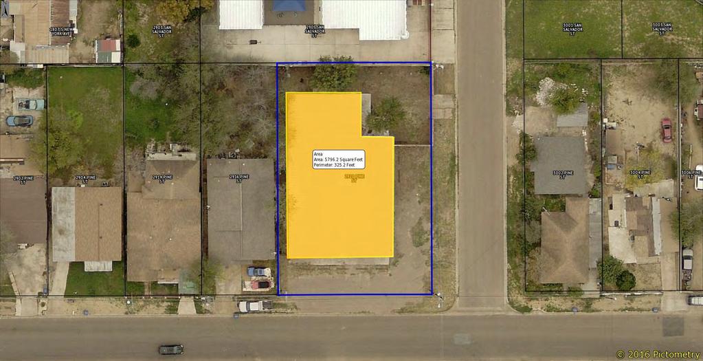
39 Planning and Zoning Commission- Regular 6. B. Meeting Date: 10/18/2018 Staff Source: Cynthia Collazo, Deputy City Manager Staff Source: Ana Villareal, Planner II Initiated by: Yzaguirre and Sons Grocery, Inc., Owner, Ceferino Izaguirre, Applicant Prior Action: None SUBJECT: Amending the Zoning Ordinance (Map) of the City of Laredo by rezoning Lots 7 and 8, Block 1764, Eastern Division, located at 2918 and 2920 Pine St., from B-1 (Limited Business District) to B-3 (Community Business District). ZC District II BACKGROUND: Council District: II The Honorable Vidal Rodriguez Proposed use: Reception Hall (Indoors) Site: The site curently has a vacant building. Surrounding land uses: North of the property is My Little School of Minds and single family residential uses. South of the property are single family residential uses,multi-family residential uses, and manufactured housing. East of the property are single family residential uses and manufactured housing. West of the property is JF Church, single family residential uses and multi-family residential uses. Comprehensive Plan: The Future Land Use Map recognizes this area as Neighborhood Mixed Use. Transportation Plan: The Long Range Thoroughfare Plan has designated Pine St. as a Major Collector. Letters sent to surrounding property owners: 35 In Favor: 0 Opposed: 0 STAFF COMMENTS:
40 Staff supportsthe proposed zone change for the following reasons: 1. The proposed B-3 District is in conformance with the Comprehensive Plan s designation of this area as Neighborhood Mixed Use (Zoning Group includes all zonings except M-1, M-2, B-4, AH, AN, FH, OG, FiH). 2. The property is located on Pine St, which is identified on the Long range Thoroughfare Plan as a Major Collector 3. The property exceeds the minimum lot width of 46 ft. for a B-3 Zoning District. (The property is approximately 92 ft.). However, Staff notes the following: 1. No other B-3 Zoning Districts are located within proximity. 2. The property does not comply with the minimum Off-Street Parking & Loading Requirements provided by Section of the Laredo Land Development Code as follow: Parking spaces required for 5,796 Sq. Ft. of the proposed use = 97 parking spaces (One (1) for each 60 Sq. Ft. of floor area)*parking spaces within 1000 ft. from the principal use must be contracted to fulfill parking requirements. *All parking areas shall be designed in such a manner that any vehicle leaving the parking areas ahall be traveling in a forward motion. P&Z RECOMMENDATION: STAFF RECOMMENDATION: Staff supports the proposed zone change. IMPACT ANALYSIS B-3 (Community Business District): The purpose of the B-3 District (Community Business District) is to provide for those businesses and services serving a trade area larger than a neighborhood, but smaller than the entire city and located primarily along minor or principal arterial streets, as classified in the Transportation Plan of the City of Laredo. It is intended for this zoning classification to exist primarily abutting minor or principal arterial streets while preserving established residential neighborhoods along such streets. Is this change contrary to the established land use pattern? Yes, this property is abutting a B-1 Zoning District to the north and west of the property and an R-3 Zoning District to the east and south of the property. Would this change create an isolated zoning district unrelated to surrounding districts? Yes, this property has no other B-3 zoning designations within proximinity.
41 Will this change adversely influence living conditions in the neighborhood? Yes, the proposed district may introduce more noise and traffic into the residential neighborhood. Are there substantial reasons why the property cannot be used in accordance with existing zoning? Yes, the existing zoning district does not allow for thee proposed use. * Uses allowed in a B-3 District include but are not limited to the following: Auto dealer new/used Heavy machinery sales/display(inside) Machinery sales/display (inside) Pawn shop Portable chemical toilet leasing/storage Commercial parking lot Auto tire repair Tire sales (indoors) Auto glass repair/tinting Car wash (self-service) Commercial car wash (detail shop) Quick lube/oil change Contractor's office/sales Parking areas for vehicles/trailers/rv's Amusement services (indoors) Billiard parlor, etc. Refer to the attached Section Permitted Uses for a list of allowed uses in B-3 Zoning District. Aerial Map Zoning Map Location Map Dimensions Map Future Land Use Map Land Use Equivalents Chart Parking Requirements Survey Pictures Attachments


42 S C A N A D A A V E S A N S A L V A D O R S T B : L : 3 & B : L : 6 & B : L : B : L : B : L : 5 S N E W Y O R K A V E B : L : 1 & B : B : B : L : 1 & 2 L : 3 L : B : L : 1 & B : L : B : L : B : B : L : 1 2 L : B : L : 8 & B : L : 1 A B : L : B : L : 8 & B : L : 3 A B : L : 2 A B : L : 6 & 5 B : L : 7 A B : L : B : L : 6 & 5 B : L : P I N E S T B : L : 4 A B : L : 3 A!I B : L : B : L : B : L : B : L : B : L : B : L : B : L : B : L : B : L : 1 & B : L : B : L : B : L : 3 & B : L : 4 AERIAL MAP 1 inch = 75 feet ZC COUNCIL DISTRICT PINE ST APPLICATION FOR B1 (LIMITED COMMERCIAL DISTRICT) -> B3 (COMMUNITY BUSINESS DISTRICT)


43 S C A N A D A A V E 2804 L: 8 & L: L: L: 6 & L: 6 & L: L: L: L: L: L: L: L: L: L: 6 L: L: L: 6 & 5 S I N D I A A V E 3102 L: L: 11 S A N S A L V A D O R S T 2803 L: 1 & L: L: L: 3 & L: 4 B L: 1 & L: 1 & L: L: L: 1A 3003 L: 2A 3005 L: 3A 3101 L: L: L: 8 & L: L: L: 6 & L: L: 5 S N E W Y O R K A V E 2902 L: L: 1 & L: L: L: L: 8 & L: L: 8 & L: 7A L: L: 6 & L: 6 & 5 L: 3112 L: L: 11 P I N E S T R L: 1A L: 2A 2805 L: L: 3A 2819 L: 4A 2901 L: L: L: L: L: L: L: L: L: 1 & L: L: L: 3 & L: 4 S I N D I A A V E 1907 L: 1 & L: 1 & L: 7-8!I 2806 L: L: L: L: L: L: L: 6A 2910 L: 5B 2912 L: 5A 3002 L: 4A & L: L: L: 6 & L: L: L: 8 & 7 ZONING MAP 1 inch = 100 feet ZC COUNCIL DISTRICT PINE ST APPLICATION FOR B1 (LIMITED COMMERCIAL DISTRICT) -> B3 (COMMUNITY BUSINESS DISTRICT)
44 N A U T L A D R Z A M O R A A V E S B U E N A V I S T A A V E S B A R T L E T T A V E S M I L M O A V E S C A N A D A A V E C R E S T L N Z A R M E X I C O A V E O L D S P A B A A V E N I D A T A M P I C O C OMA L L O O P M I N A V E R D E R D!I B U R R S T J A M E S O N S T F O S T E R S T LOCATION MAP 1 inch = 1,250 feet S S M E N D I O L A A V E M A V E A D O W E B A R R I O S S T S U S S U R B A H N A V E S U R B A H N A V E MEADOW AVE S M A L I N C H E A V E B O U L A N G E R S T H I G H W A Y 8 3 S B U E N A V I S T A A V E S M E A D O W A V E S A C R E D H E A R T D R S M A L I N C H E A V E V I C E N T E S T R O B E R T O V A L D E Z D R S M A L I N C H E A V E S B A R T L E T T A V E S B A R T L E T T A V E S B A R T L E T T A V E S B A R T L E T T A V E ZC COUNCIL DISTRICT PINE ST S J A R V I S A V E S J A R V I S A V E S U S H I G H W A Y 8 3 S J A R V I S A V E S J A R V I S A V E 83 B I S M A R K S M A R T I N A V E C H E S T N U T S T S M A R T I N A V E S T S A N L U L I G A R D E S T B A R R I O S S I S S T T UV 260 B O U L A N G E R S T S A L T I L L O S T Z A C A T E C A S S T S M A R T I N A V E C R O S S S T S M I L M O A V E S M I L M O A V E S T E X A S A V E P A L O B L A N C O S T S M I L M O A V E B L A I N E S T N O R T O N S T S T E X A S A V E S L O U I S I A N A A V E S A R K A N S A S A V E N A P O L E O N S T S A N T A C L A R A S T P E C A N S T S A R K A N S A S A V E S N E W Y O R K A V E T I N A J A S T T H U R M A N S T B A Y A R D S T D I A Z S T S C A N A D A A V E B I S M A R K S T S A N T A B A R B A R A S T PINE ST M I L K S S I N D I A A V E V I C E N T E S T S S M I T H A V E C H A C O T A S T C O L OMB I A D R T R O S S S T S A N S A L V A D O R S T M O N T E R R E Y S T S C A N A D A A V E S C A N A D A A V E S I N D I A A V E S S M I T H A V E P O T OM A C L O O P W I L S O N L N S E J I D O A V E Ejido J A I M E Z A P A T A M E M O R I A L C O O L I D G E D R B O N A P A R T E L N D R Y D E N A V E N OP MA T R U L O T R U M A R O ETA Q U E R L O O L A T E R R A Z A W A Y E I S N P E N H O W E R L N Z A M O R A L O O P Z A C A T E C A S S T H W Y R E A G A A L M O N D M A N T E D R D R M A N D E L A C T C N L N R E S E S T O U TH K J O H N S O N D R D R J O H N S O N L N C A S H E W A V E N P I N E S T C A B O S A N L U C A S S T L O ST K E N N EDY L O O P M O R E LO S D R T E P I C D R N U B E S D R L O O PC R EEK C H I A A Y M A S G U A V E Wormser C E N T U S U N S E T L O O C E N T U R Y D R C A N C UN L O O P P A S I N A C U L I A P A N D R C S S L O A N U B E S D R D U R C A L L E A A A V E N G O C E N TU R Y D U RA N G O N I D A S E R E N O D R H O R I Z O N C I R R Y D R M O N C L O V A D C U A T R O V I E N T O S D R W O R M S E R R D R T C E N T U R Y P D R A V E F U E N T E L N B CI R L T A C T L U E B O N N E T L N O I C A B L V D R D NI E B L A D R B R U M O S O C T APPLICATION FOR B1 (LIMITED COMMERCIAL DISTRICT) -> B3 (COMMUNITY BUSINESS DISTRICT) M A R I G O L D C I R A V E N I D A T U L I P C I R M E XI C O H O R IZO N L O OP C A L L E A C A P U LC O C A P I T O L L N C A L L E G U A D A L A J A R A A V E N I D A LO S P R E S I D E NT E S N D E R A D R A G U A N I E V E D R C L A R A T I O N D R E D UV 20 N O R T H M E R I D A D R H A N C O C K C T P A T R I C K H E N R Y D R W I T H E R S P O ON L Y M A N H A L L D R M A N Z A N I L L O S T M E R I D A D R T O R R E O N S T J A L A P A S T M O R E L I A D R N J O H N A D A M S R D L O O P G E O R G E R E A D D R C A M P E CHE D R P A U L R E V E R E D R D O R A D O D R L I S H T R C U A T R O V I E N T O S R D A N G U S D R D O R A D O A V E
45 S C A N A D A A V E S A N S A L V A D O R S T S N E W Y O R K A V E P I N E S T !I DIMENSIONS MAP 1 inch = 75 feet ZC COUNCIL DISTRICT PINE ST APPLICATION FOR B1 (LIMITED COMMERCIAL DISTRICT) -> B3 (COMMUNITY BUSINESS DISTRICT)
46 S I N D I A A V E S I N D I A A V E S A N S A L V A D O R S T High Density Residential S N E W Y O R K A V E Neighborhood Mixed-Use P I N E S T MAJOR COLLECTOR S C A N A D A A V E!I FUTURE LANDUSE MAP 1 inch = 100 feet ZC COUNCIL DISTRICT PINE ST APPLICATION FOR B1 (LIMITED COMMERCIAL DISTRICT) -> B3 (COMMUNITY BUSINESS DISTRICT)
47 Land Use Equivalents Chart New Land Use Types Current Zoning Groups Agricultural / Rural AG Low Density Residential R-1,R-1-MH, R-1A, R-1B, R-S, B-1R, and R-O with exceptions * Medium Density Residential R-1, R-O, R-2, B-1R, R1-B, Small format market High Density Residential R-3, R-2, B-1R, B-1, R-O Neighborhood Mixed-Use ALL EXCEPT M-1, M-2, B-4, AH, AN, FH, OG, FiH Mixed-Use Center ALL EXCEPT, M-1, M-2, AH, AN, FH, OG. B4 allowed with exceptions** Downtown Mixed-Use CBD, R-1, R-2, R-3, R-1B, R-1A, R-O, AE Institutional CF, MF Light Industrial M-1, B-4, B-3 Heavy Industrial M-1, M-2, B-4, B-3, FiH Transportation AH, AN Parks * RO within a Low Density Residential is allowed with the exception of restaurants. ** Land uses allowed under a B4 are allowed with the exception of the following uses***: Farms, General (Crops & Livestock) Farms, General (Livestock/Ranch) Bulk Grain And/Or Feed Storage Veterinarian (Outdoor Animal Confinement) Stables (Private, Principle Use) Stables (Private, Accessory Use) Stables (Commercial) Auto Wrecker Service Inoperable Vehicle Holding Yard Jail Halfway House Scrap/Waste Recycle Collection Zoo Horse Training Facility Amusement Redemption Machine Establishment Auto Impound Yards Auto Salvage Yards Transit and Maintenance Vehicle Equipment Facility Collection Container The intent of this table is to provide a transitional language between the uses recommended within the vision of this plan and the current land development uses which are organized through the use of zones. When the city s land development code is revised and adopted according to this plan, this table will no longer be necessary. This table should not be used to directly translate the current zoning to new land development code revisions. City staff should use discretion and best planning practices if using this table as guide in any approval process. ***Note: exceptions only apply to the extent that they do not contradict any other ordinances such as the Urban Agriculture Ordinance, as an example VIVA LAREDO
48 The city has no water features; only Casa Blanca. North Laredo Central Park could be turned into a river walk with an urban recreational lake surrounded by businesses. Create incentives for job creation, economic development, and alternative land development options (higher and lower density). Land Uses Place types and neighborhoods are made up by different land uses in the future land use map. Specified land uses however, are not meant to equate to singleuse zoning areas. Rather a land use type in the future land use map describes the overall character of a neighborhood. Neighborhoods are generally made up of residential and mixed-use designations: Low-Density Residential describes a neighborhood whose character is primarily defined by single-family homes. A diverse range of lot sizes and unit types is encouraged, along with an interconnected network of blocks, streets and public spaces. Denser housing types such as duplexes, fourplexes and small apartment buildings should be designed to fit into the character of a single-family residential neighborhood. Thoughtfully designed small office, retail or mixed-use buildings can also be built at key intersections to provide neighborhood amenities. Civic buildings should also respect the character of a primarily residential neighborhood, but can also be used as landmarks. Medium-Density Residential describes a neighborhood that is primarily residential in character, but includes a full range of range of residential building types. These include singlefamily homes in small and medium sized lots, attached rowhouses and apartment buildings. Thoughtfully designed small office, retail or mixed-use buildings can also be built at key intersections to provide neighborhood amenities. Civic buildings should also respect the character of a primarily residential neighborhood, but can also be used as landmarks. Low Density Residential Medium Density Residential High Density Residential LAND USE PATTERNS 1.15
49 High-Density Residential describes a neighborhood whose character is primarily defined by multi-family residential building types, but can also include single family homes in small lots and neighborhood-serving businesses. A diverse range of housing types is encouraged, including attached rowhouses, small and large apartment buildings, courtyard buildings and small mixeduse buildings. Small office, retail or mixed-use buildings can also be built at key intersections to provide neighborhood amenities. Civic buildings should be sited to provide landmarks to the neighborhood. Neighborhood Mixed-Use Neighborhood Mixed-Use describes a neighborhood-serving mixed-use district that includes multistory, mixed-use buildings with commercial, office and residential uses. Multifamily residential buildings are also appropriate as a transition between main street shopping areas and primarily residential neighborhoods. Mixed-Use Center describes a mixed-use center that includes multistory, mixed-use buildings with commercial, office and residential uses. Regional or neighborhood oriented shopping areas are encouraged as a primary feature. Multi-family residential buildings are also appropriate as a transition between main street shopping areas and primarily residential neighborhoods. Downtown Mixed-Use describes the most intense urban development in the City of Laredo. Reserved primarily for downtown Laredo, it includes multi-story mixed-use buildings with commercial, office and residential uses. Multifamily residential buildings are also appropriate as a transition between the downtown and primarily residential neighborhoods. The addition of residential uses on the upper floors of downtown buildings is encouraged as a priority for downtown revitalization. Mixed-Use Center Downtown Mixed-Use VIVA LAREDO
50 12/30/2016
51 (zz) Tool rental (with inside & One(1)pereach200sq.ft I or outside storage) (aaa) Truck stop One ( 1) per every 500 sq. ft. office I reception space plus one (1) for each service bay (exterior or interior) and two (2) stacking spaces for each service bay. (bbb) Self-service storage/mini- Four (4) spaces plus two (2) for employees. storage (3) RECREATIONAL OR ENTERTAINMENT (a) Bars, night clubs, dance halls, One (1) for each 60 sq. ft. of floor area, or one (1) cantinas space for each three (3) seats, whichever is greater. (b) Reception halls, dance halls One (1) for each 60 sq. ft. of floor area, or one (1) space for each three (3) seats, whichever is greater. ( 1) With liquor sales (beer, wine, One (1) for each 60 sq. ft. of floor area, or one (1) etc.) space for each three (3) seats, whichever is greater. (2) Without liquor sales (BYOB) One (1) for each 60 sq. ft. of floor area, or one (1) space for each three (3) seats, whichever is greater. (c) Bowling alleys Four (4) for each alley or lane plus one (1) additional space for each 100 sq. ft. of the area used for restaurant, cocktail lounge, or similar use. (d) Skating rinks One (1) for each 100 sq. ft. of floor area used for the activity. (e) Outdoor swimming pools or One (1) for each five (5) person capacity plus one (1) other public or private for each four (4) seats or one (1) for each 30 sq. ft. floor recreation facilities area used for seating purposes whichever is greater. (f) Auditoriums, sports arenas One ( 1) for each four ( 4) seats plus one ( 1) each 30 sq. ft. floor area used for non-permanent seating. (g) Amusement Redemption One ( 1) for each 100 sq. ft. of floor area or one ( 1) Machine Establishments space for each four (4) seats, whichever is greater. (h) Theater (both motion picture One (1) for every four (4) seats. and live) (i) Laser Hide and Seek One (1) per six (6) seats or one (1) per 30 sq. ft. of area Games(indoor & outdoor) used for non-permanent seating. U) Go-Cart track One ( 1) per six (6) seats or one ( 1) per 30 sq. ft. of area used for non-permanent seating. (k) Golf course/driving range Six (6) per hole/ one (1) per six (6) seats or one (1) per 30 sq. ft. of club house if no permanent seats. (I) Shooting range (indoor and One (1) per six (6) seats or one (1) per 30 sq. ft. of area V-13
 (6) In the R-0 District, parking areas shall not be located in a manner that would destroy landscaping, such as trees, shrubs, lawns.")
52 annual basis as a condition of authorization to continue the business and shall be in effect until the uses cease, title, or legal share) in off-premises parking. (As amended , Ord. # ) (6) In the R-0 District, parking areas shall not be located in a manner that would destroy landscaping, such as trees, shrubs, lawns. In order to accomplish this, the parking space requirements of Section (p) may be modified by up to twenty-five (25) percent, and maneuvering space may be waived. U) DISABLED VEHICLES The parking of a non-operable vehicle shall not be permitted on public rights-of-way. These vehicles shall not be stored on any lot unless it is stored in an enclosed garage or other accessory building. (k) JOINT USE OF PARKING SPACES (ON-SITE) Two or more non-residential uses may jointly, having cooperatively entered into a recorded written agreement or contract to be in effect until the uses cease, provide and use parking spaces when their hours of operation do not overlap (meaning none of the uses sharing the facilities require the off-street parking facilities at the same time). (I) WHEEL BLOCKS Whenever a parking lot extends to a property line, wheel blocks or other suitable devices shall be installed to prevent any part of a parked vehicle from extending beyond the property line. (m) ACCESS AND MANEUVERING SPACE REQUIREMENTS All parking areas, excluding single family or two family residences, shall be designed in such a manner that any vehicle leaving the parking area shall be traveling in a forward motion. Maneuvering space dimension shall be as provided in Section (c) of this Section, and shall be off the public right-of-way. Access driveways for parking areas or loading spaces shall be located in such a way that any vehicle entering or leaving such area shall be clearly visible for a reasonable distance to any pedestrian or motorist approaching the access or driveway from a public or private street. (n) WIDTH OF ACCESS DRIVEWAY IN BUSINESS AND INDUSTRIAL DISTRICTS The entrances and exits to the parking area shall be clearly marked. Entranceways or exits shall maintain the following minimum standards: (1) For one-way traffic, a minimum width of fourteen (14) feet is required. (2) Access driveways for two-way traffic shall have a minimum width of twenty four (24) feet, but not to exceed thirty (30) feet. (3) Parking areas having more than one aisle or driveway shall have directional signs or marking in each aisle or driveway. (4) On corner lots, in business or industrial districts, driveways shall be at least fifty (50) feet from the property corner nearest the intersection. (o) PARKING AREAS- MODIFICATIONS The Board may authorize or appeal a modification, reduction, or waiver of all of these parking requirements, except that when there is a change in use in a B-1 or B-3 district (when such a new use requires additional parking), said additional parking requirements shall not be waived or reduced, nor shall maneuvering space requirements be waived or reduced, where access is to those major streets listed on the current, functional classification map of the City, unless in the R-0 District. In no case shall there be V-7
53

54 ZC Lots 7 and 8, Block 1764, Eastern Division 2918 and 2920 Pine St. B-1 to B-3 1
55 2
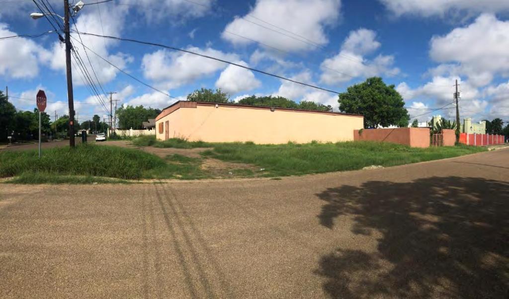
56 Planning and Zoning Commission- Regular 6. C. Meeting Date: 10/18/2018 Staff Source: Cynthia Collazo, Deputy City Manager Staff Source: Ana Villareal, Planner II Initiated by: Zepold Properties, Ltd., owner; Tacos Express, applicant. Prior Action: None SUBJECT: Amending the Zoning Ordinance (Map) of the City of Laredo by authorizing a Special Use Permit for a Restaurant Serving Alcohol on Lots 7, 8 and 9, Block 71, Eastern Division, located at 2020 Corpus Christi St. ZC District III BACKGROUND: Council District: III The Honorable Alejandro Perez, Jr. Proposed use: Restaurant Serving Alcohol Site: The site is currently operating as Taco Express Restaurant. Surrounding land uses: North of the property is Danny's Restaurant and single family residential uses. South of the property is Quickie Bakery, mini torage units, Ruthe B. Cowl Rehabilitation Center and single family residential uses.east of the property is the Metro PC, Pare de Sufrir, The Universe Church, Sun Loan Company, Merit Finance, Tax Services, Illumina Beauty Salon, Fire Stone, Lira's Restaurant and the LouisFranklin Center. West of the site is the Dioceses of Laredo Chancery, Learning Center, Auto Insurance,a vacant lot and single family residential uses. Comprehensive Plan: The Future Land Use Map recognizes this area as Neighborhood Mixed Use. Transportation Plan: The Long Range Thoroughfare Plan has no classification for Corpus Christi St., but has identified Malinche Ave. as a Major Collector. Letters sent to surrounding property owners: 21 In Favor: 0 Opposed: 0 STAFF COMMENTS:
57 Staff supports the proposed Special Use Permit for the following reasons: 1. The proposed district is in compliance with the Comprehensive Plan s designation for this property as Neighborhood Mixed Use. 2. The proposed use is appropriate along a major collector and is compatible with the commercial uses along Corpus Christi St. 3. The property complies with the Off-Street Parking Requirements as provided by Section of the Laredo Land Development Code. 4. The property complies with the minimum distance separation distance of three hundred (300) feet to any church, public school, public park, residential structure or residential zoning district as required by the Laredo Land Development Code. Off-Street Parking Requirements Section Parking spaces required for the proposed use = 27 parking spaces (Twelve parking spaces per 1,000 sq. ft.) Parking spaces provided on site= 27 parking spaces P&Z RECOMMENDATION: STAFF RECOMMENDATION: Staff supportsthe proposed Special Use Permit. IMPACT ANALYSIS Should the Commission recommend approval of the proposed SUP, staff suggests the following conditions: 1. The Special Use Permit is issued to Ever Kissi, Owner; and Tacos Express LLC., Applicant, for a restaurant serving alcohol, and is non-transferable. 2. The Special Use Permit is restricted to approx. 2,268 S.F. as per the site plan, Exhibit A, which is made part hereof for all purposes. 3. Hours of operation shall be Sunday through Thursday from 8 a.m. to 12:00 a.m (midnight), Fridays and Saturdays from 8:00 am to 1:00 a.m., as per Exhibit B. 4. The establishment must make provisions to keep litter to a minimum, and to keep it from blowing onto adjacent streets and properties. 5. Signage shall be consistent with the City s Sign Ordinance and TABC rule or regulation. 6. Off-street parking shall be provided in accordance with the City of Laredo Land Development Code. 7. There shall be no ground vibrations created or sustained on the site which are perceptible without instruments at any point on any property adjoining the subject property. 8. At all times the restaurant is open to the public for business; it shall continually maintain and serve food from its full service menu. 9. The restaurant shall not exceed the Occupant Load as set forth in the Certificate of
58 9. The restaurant shall not exceed the Occupant Load as set forth in the Certificate of Occupancy with Occupant Load. 10. The restaurant shall, during all hours of operation, maintain, free from obstruction or impediment to full instant use in the case of fire or other emergency, all exit accesses, exits or exit discharges. 11. The restaurant shall undergo an annual Fire Inspection. 12. All permits, licenses, certifications and inspections required by the codes and ordinances of the City of Laredo shall be kept up to date and current including but not limited to Food Manager License (annual), Food handler s Permit (annual), and Certificate of Occupancy with Occupant Load, Occupant Load being the approved capacity of a building or portion thereof. 13. Landscaping of property shall be provided in accordance with the City of Laredo Land Development Code. 14. Lighting of property shall be screened to avoid adverse impact on adjacent residential neighborhoods. 15. Owner shall provide a 7 high opaque fence along property lines which abut or adjoin any residential zones/uses. 16. Owner shall comply with Building, Health, Safety, and all applicable codes and regulations as required. 17. Owner shall provide parking spaces in compliance with Section and of the Laredo Land Development Code, for commercial parking, parking space dimensional requirements, loading space requirements and dimensions, paving, drainage, maintenance, lighting, location of parking spaces, disabled vehicles, joint use of parking spaces (on-site), wheel blocks, access and maneuvering space requirements, width of access driveway in business and industrial districts, as required by ordinance. 18. The restaurant shall maintain and comply with the Sign regulations as per TABC (not to exceed the required alcohol sales percentage). 19. The restaurant shall provide the City of Laredo Planning Department with a copy of the current TABC License to include but not limited to any renewals or amendments as they occur. Aerial Map Zoning Map Location Map Dimensions Map Measurements Map Future Land Use Map Land Use Equivalents Chart Parking Requirements Attachments


59 B : L : B : L : B : 7 1 L : 1 & B : 7 1 L : B : 7 1 L : 4 & B : 7 1 L : B : L : B : L : B : L : 7 N URBAHN AVE 55.56' B : 7 1 L : 1 2 & B : 7 1 L : B : 7 1 L : B : 7 1 L : B : 7 1 L : 7 N MALINCHE AVE 55.56' B : L : B : L : B : L : 6 E CORPUS CHRISTI ST 55.56' B : 7 3 L : 4!I B : 7 3 L : 3 & 4 AERIAL MAP 1 inch = 58 feet B : 7 4 L : 1-3 ZC COUNCIL DISTRICT CORPUS CHRISTI ST B : 7 4 L : 4 & B : 7 4 L : 5 & B : L : 1 APPLICATION FOR S.U.P. (SPECIAL USE PERMIT) -> RESTAURANT SERVING ALCOHOL B : L : B : L : 3 & 4


60 1819 L: 5 & L: L: 12 & L: L: L: L: L: L: L: L: L: L: L: L: L: L: L: L: L: 8 & L: 12 & L: 11 & L: 9 & L: 8 & L: L: L: L: L: L: L: L: L: L: L: R-1 GARFIELD ST 55.56' L: 1819 L: 5 & 6 N BUENA VISTA AVE 55.56' 1901 L: 1 & L: L: L: 2 & L: 11 & L: 3 & L: L: L: L: L: 7 N URBAHN AVE 55.56' 2001 L: 1 & L: 12 & L: L: L: O L: 4 & O L: O O L: L: O-100 N MALINCHE AVE 55.56' E CORPUS CHRISTI ST 55.56' 2100 L: L: L: L: L: L: L: L: 5 N BARTLETT AVE 55.56' 2201 L: L: L: L: L: L: 6!I 1901 L: L: 8 ZONING MAP 1 inch = 117 feet 1901 L: L: L: L: 6 & L: 6 & L: L: 3 & 4 B-1 ZC COUNCIL DISTRICT CORPUS CHRISTI ST 2008 L: 12 & L: 1-3 LAREDO ST 55.56' 2010 L: L: 11 & L: 4 & L: L: 5 & L: 8& L: L: L: O O L: 7 B O O L: 3& L: 6&5 APPLICATION FOR S.U.P. (SPECIAL USE PERMIT) -> RESTAURANT SERVING ALCOHOL 1319 L: L: 8 R-O 1319 L: L: L: L: 6
61 MC CLELLAND LYON MALINCHEAV PARK ST SAN FRANCISCO SPRINGFIELD CLARK ST BARTLETT MC CLELLAND GALVESTON CORPUS CHRISTI SAN EDUARDO ITURBIDE ST HENDRICKS AVE HENDRICKS AV MARKET 83 RK ANSAS AVE A UV 359!I MEADOW AVE UV 260 LOCATION MAP 1 inch = 1,667 feet ZC COUNCIL DISTRICT CORPUS CHRISTI ST APPLICATION FOR S.U.P. (SPECIAL USE PERMIT) -> RESTAURANT SERVING ALCOHOL
62 N URBAHN AVE 55.56' N MALINCHE AVE 55.56' E CORPUS CHRISTI ST 55.56' !I DIMENSIONS MAP 1 inch = 58 feet ZC COUNCIL DISTRICT CORPUS CHRISTI ST APPLICATION FOR S.U.P. (SPECIAL USE PERMIT) -> RESTAURANT SERVING ALCOHOL


63 DISTANCE TO NEAREST RESIDENTIAL DISTRICT: 399.1' RESIDENTIAL USE: 392.4' NEAREST SCHOOL: R-1 GARFIELD ST 55.56' N MALINCHE AVE 55.56' N URBAHN AVE 55.56' B E CORPUS CHRISTI ST 55.56' B-3 B-3!I MEASUREMENTS 1 inch = 81 feet ZC COUNCIL DISTRICT CORPUS CHRISTI ST APPLICATION FOR S.U.P. (SPECIAL USE PERMIT) -> RESTAURANT SERVING ALCOHOL
64 Insitutional N BUENA VISTA AVE 55.56' Low Density Residential GARFIELD ST 55.56' N URBAHN AVE 55.56' Neighborhood Mixed-Use MAJOR COLLECTOR E CORPUS CHRISTI ST 55.56' N BARTLETT AVE 55.56' Downtown Mixed-Use!I ZC FUTURE LANDUSE MAP COUNCIL DISTRICT 3 1 inch = 117 feet 2020 CORPUS CHRISTI ST LAREDO ST 55.56' APPLICATION FOR S.U.P. (SPECIAL USE PERMIT) -> RESTAURANT SERVING ALCOHOL
65 Land Use Equivalents Chart New Land Use Types Current Zoning Groups Agricultural / Rural AG Low Density Residential R-1,R-1-MH, R-1A, R-1B, R-S, B-1R, and R-O with exceptions * Medium Density Residential R-1, R-O, R-2, B-1R, R1-B, Small format market High Density Residential R-3, R-2, B-1R, B-1, R-O Neighborhood Mixed-Use ALL EXCEPT M-1, M-2, B-4, AH, AN, FH, OG, FiH Mixed-Use Center ALL EXCEPT, M-1, M-2, AH, AN, FH, OG. B4 allowed with exceptions** Downtown Mixed-Use CBD, R-1, R-2, R-3, R-1B, R-1A, R-O, AE Institutional CF, MF Light Industrial M-1, B-4, B-3 Heavy Industrial M-1, M-2, B-4, B-3, FiH Transportation AH, AN Parks * RO within a Low Density Residential is allowed with the exception of restaurants. ** Land uses allowed under a B4 are allowed with the exception of the following uses***: Farms, General (Crops & Livestock) Farms, General (Livestock/Ranch) Bulk Grain And/Or Feed Storage Veterinarian (Outdoor Animal Confinement) Stables (Private, Principle Use) Stables (Private, Accessory Use) Stables (Commercial) Auto Wrecker Service Inoperable Vehicle Holding Yard Jail Halfway House Scrap/Waste Recycle Collection Zoo Horse Training Facility Amusement Redemption Machine Establishment Auto Impound Yards Auto Salvage Yards Transit and Maintenance Vehicle Equipment Facility Collection Container The intent of this table is to provide a transitional language between the uses recommended within the vision of this plan and the current land development uses which are organized through the use of zones. When the city s land development code is revised and adopted according to this plan, this table will no longer be necessary. This table should not be used to directly translate the current zoning to new land development code revisions. City staff should use discretion and best planning practices if using this table as guide in any approval process. ***Note: exceptions only apply to the extent that they do not contradict any other ordinances such as the Urban Agriculture Ordinance, as an example VIVA LAREDO
.")


66 The city has no water features; only Casa Blanca. North Laredo Central Park could be turned into a river walk with an urban recreational lake surrounded by businesses. Create incentives for job creation, economic development, and alternative land development options (higher and lower density). Land Uses Place types and neighborhoods are made up by different land uses in the future land use map. Specified land uses however, are not meant to equate to singleuse zoning areas. Rather a land use type in the future land use map describes the overall character of a neighborhood. Neighborhoods are generally made up of residential and mixed-use designations: Low-Density Residential describes a neighborhood whose character is primarily defined by single-family homes. A diverse range of lot sizes and unit types is encouraged, along with an interconnected network of blocks, streets and public spaces. Denser housing types such as duplexes, fourplexes and small apartment buildings should be designed to fit into the character of a single-family residential neighborhood. Thoughtfully designed small office, retail or mixed-use buildings can also be built at key intersections to provide neighborhood amenities. Civic buildings should also respect the character of a primarily residential neighborhood, but can also be used as landmarks. Medium-Density Residential describes a neighborhood that is primarily residential in character, but includes a full range of range of residential building types. These include singlefamily homes in small and medium sized lots, attached rowhouses and apartment buildings. Thoughtfully designed small office, retail or mixed-use buildings can also be built at key intersections to provide neighborhood amenities. Civic buildings should also respect the character of a primarily residential neighborhood, but can also be used as landmarks. Low Density Residential Medium Density Residential High Density Residential LAND USE PATTERNS 1.15


67 High-Density Residential describes a neighborhood whose character is primarily defined by multi-family residential building types, but can also include single family homes in small lots and neighborhood-serving businesses. A diverse range of housing types is encouraged, including attached rowhouses, small and large apartment buildings, courtyard buildings and small mixeduse buildings. Small office, retail or mixed-use buildings can also be built at key intersections to provide neighborhood amenities. Civic buildings should be sited to provide landmarks to the neighborhood. Neighborhood Mixed-Use Neighborhood Mixed-Use describes a neighborhood-serving mixed-use district that includes multistory, mixed-use buildings with commercial, office and residential uses. Multifamily residential buildings are also appropriate as a transition between main street shopping areas and primarily residential neighborhoods. Mixed-Use Center describes a mixed-use center that includes multistory, mixed-use buildings with commercial, office and residential uses. Regional or neighborhood oriented shopping areas are encouraged as a primary feature. Multi-family residential buildings are also appropriate as a transition between main street shopping areas and primarily residential neighborhoods. Downtown Mixed-Use describes the most intense urban development in the City of Laredo. Reserved primarily for downtown Laredo, it includes multi-story mixed-use buildings with commercial, office and residential uses. Multifamily residential buildings are also appropriate as a transition between the downtown and primarily residential neighborhoods. The addition of residential uses on the upper floors of downtown buildings is encouraged as a priority for downtown revitalization. Mixed-Use Center Downtown Mixed-Use VIVA LAREDO
68 UD Veterinary hospital One (1) per each 200 sq. ft. up to 5000 sq. ft. ; one (1) per each 250 sq. ft. if greater than 5000 sq. ft. (kk) Banks, financial institutions One (1) for each 200 sq. ft. of floor area plus eight (8) stacking spaces for each drive-thru service lane; two (2) stacking spaces per ATM. (II) Pawn shop One (1) per each 200 sq. ft. up to 5000 sq. ft.; one (1) per each 250 sq. ft. if greater than 5000 sq. ft. (mm) Martial arts studio One ( 1) per each 200 sq. ft. (nn) Dance/Gymnastics/Performing One ( 1) per each 200 sq. ft. arts studio (oo) Barber or Beauty shop One ( 1) per each 200 sq. ft. (pp) Dry cleaning One ( 1) per each 200 sq. ft. plus two (2) stacking spaces for drive-through. (qq) Offices One (1) for each 250 sq. ft. of floor area. (rr) Medical Clinic (physician and/or One (1) for each 200 sq. ft. of floor area. dentist) (ss) Medical Clinic (chiropractic) One (1) for each 200 sq. ft. of floor area. (tt) Medical Clinic (physical One (1) for each 200 sq. ft. of floor area. therapy) (uu) Medical Clinic (optometry) One (1) for each 200 sq. ft. of floor area. (vv) Restaurants ( 1) Sit down restaurants Twelve (12) parking spaces per 1,000 sq. ft. (2) Fast food (with or without drive- One ( 1) per each 200 sq. ft.; with drive-through add six through) (6) stacking spaces for each service lane. (3) Carry-out restaurants (no One (1) parking space per 200 sq. ft. customer seating or dining area) (ww) Flea markets One (1) parking space per booth plus one (1) parking space for each 2,000 sq. ft. of land area not used for parking. (xx) Bed and Breakfast One (1) parking space for each guestroom plus one (1) parking space for the owner I occupant and one ( 1) space for each employee. Except for the driveway, the front yard shall not be used for parking in a Residential Office (R-0) District. (yy) All other types of commercial One ( 1) for each 200 sq. ft. of business or commercial /service uses floor area uses permitted in any business district. V-12
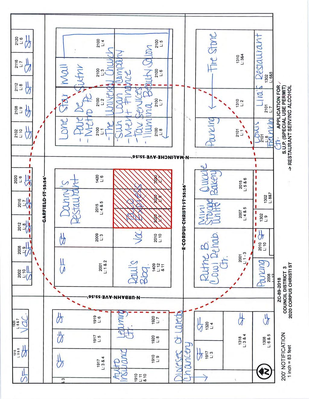
69
70
71

72 ZC Lots 7 and 8, Block 1764, Eastern Division 2918 and 2920 Pine St. B-1 to B-3 1
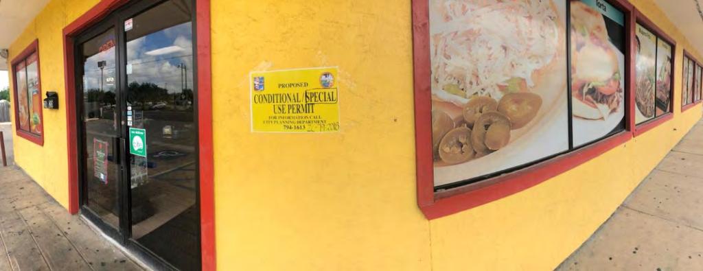
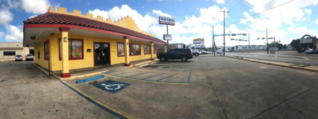
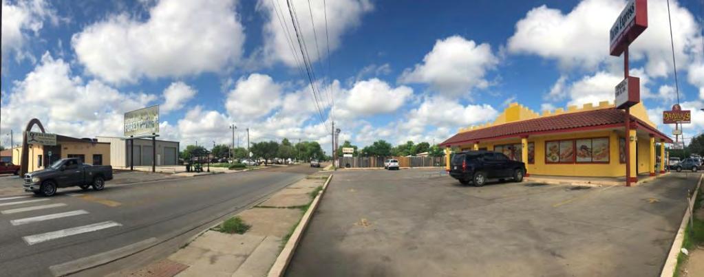
73 2
74 Planning and Zoning Commission- Regular 6. D. Meeting Date: 10/18/2018 Staff Source: Alejandrina Sanchez, Planner Initiated by: The Hidden Heaven Venture/Nestor Garza, Jr., Owner/Applicant and Edward D. Garza, P.E., Representative Prior Action: None. SUBJECT: Amending the Zoning Ordinance (Map) of the City of Laredo by rezoning approximately 5.66 acres, as further described by Metes and Bounds Exhibit A, located at East of Piedmont St. from RSM (Residential Suburban Multi-Family District) to R-1(Single Family Residential District). ZC District VI BACKGROUND: Council District: VI The Honorable Charlie San Miguel Proposed use: residential Site: The site is currently raw undeveloped land. Surrounding land uses: North, south, east and west of the property is single family residential dwellings. Half of the property to the north abuts raw undeveloped land. Comprehensive Plan: The Future Land Use Map recognizes this area as High Density Residential. Transportation Plan: The Long Range Thoroughfare Plan does not identify Piedmont St or Plantation East Drive. Letters sent to surrounding property owners: 44 In Favor: 0 Opposed: 0 STAFF COMMENTS:
75 Staff does not support the proposed zone change because for the following reason: 1. the proposed R-1 District is not in conformance with the Comprehensive Plan s designation of this area as High Density Residential However, staff notes the following: 1. The proposed use is compatible with the single family residential uses and zones in the area. P&Z RECOMMENDATION: The P & Z Commission, in a _ to _ vote, recommended of the zone change. STAFF RECOMMENDATION: Staff does not support the proposed zone change. IMPACT ANALYSIS R-1 (Single Family Residential District): The purpose of the R-1 District (Single Family Residential District) is to provide an area for residential uses and those public and semi-public uses normally considered an integral part of the residential neighborhood they serve. In addition, this district provides for the subdivision of single family residential lots with a minimum of 6,000 square feet. Is this change contrary to the established land use pattern? No. The existing uses along this area are single family residential. Would this change create an isolated zoning district unrelated to surrounding districts? No. The property abuts an R-1 zoning district to the north, east, west and south. Will change adversely influence living conditions in the neighborhood? No, the area is already a residential use in nature. Are there substantial reasons why the property cannot be used in accordance with existing zoning? No. The existing RSM (Residential Suburban Multi-Family District) does allow for residential uses, except for the single family residential use the applicant wants to introduce. Color Maps - ZC Color Pictures - ZC Attachments
76 Exhibit A - ZC
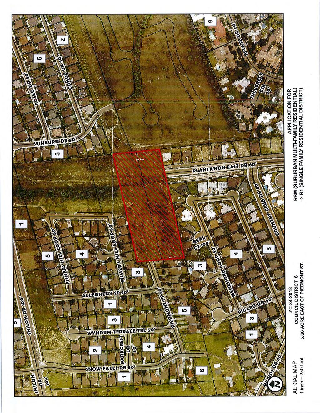
77
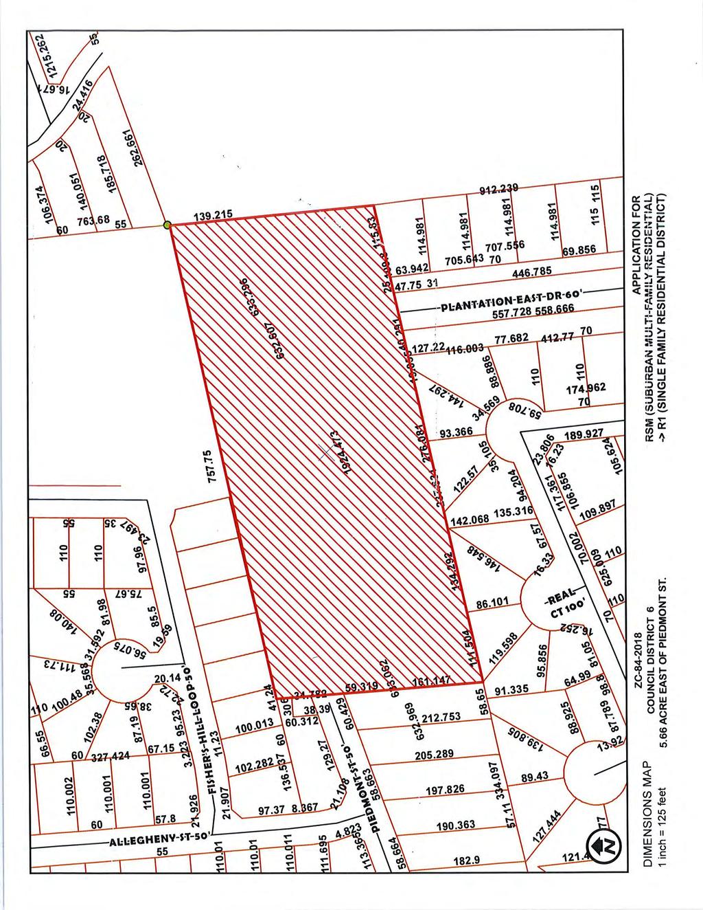
78
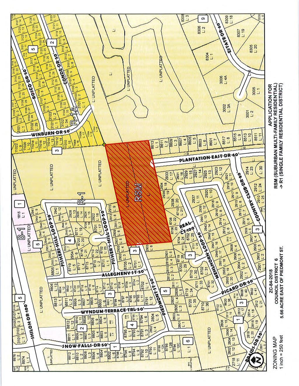
79
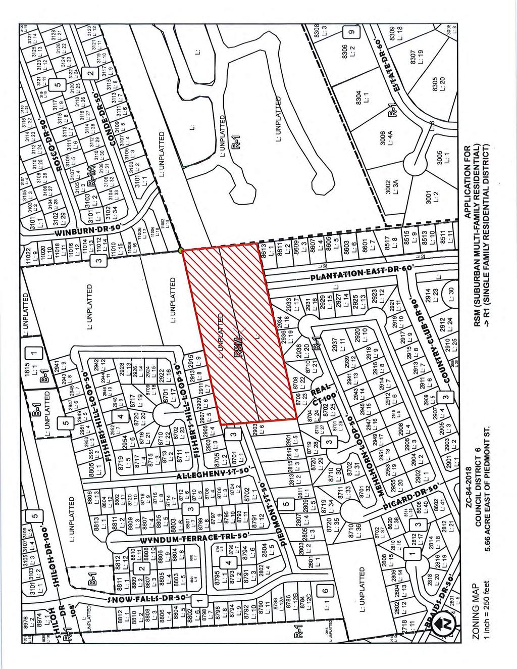
80
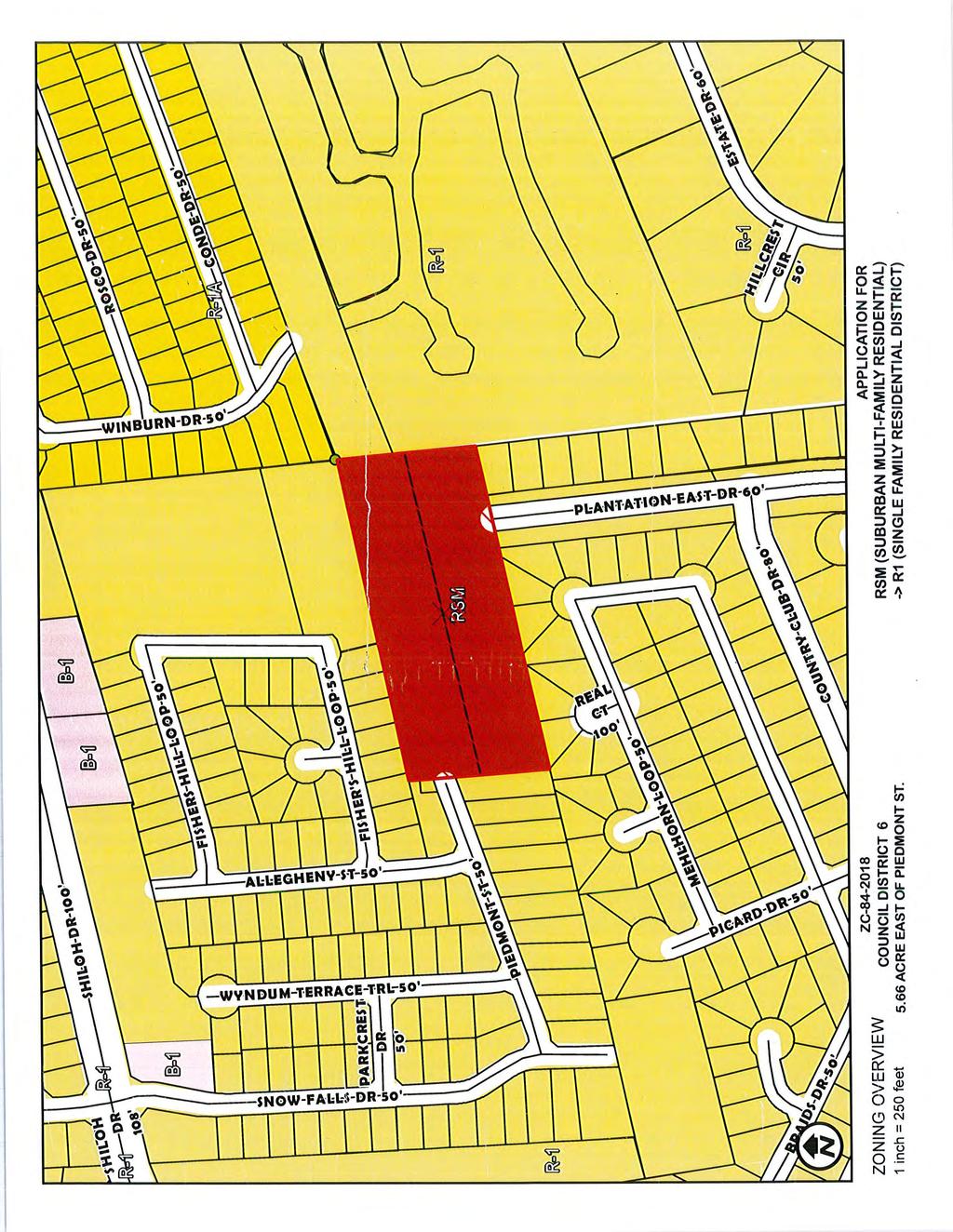
81
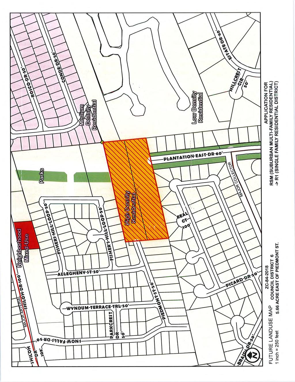
82
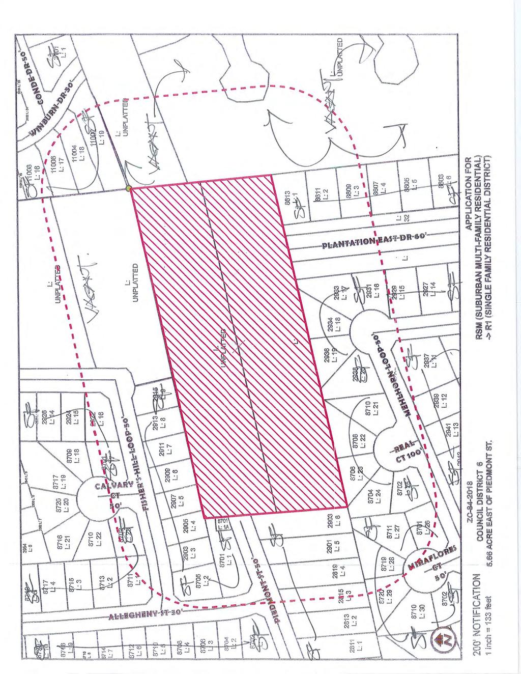
83
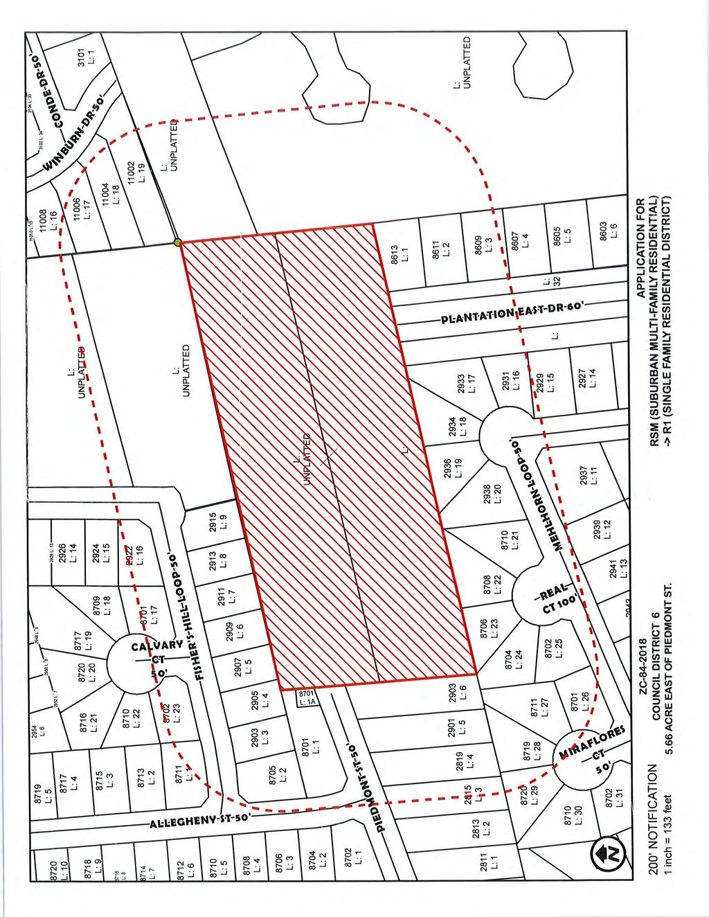
84
85
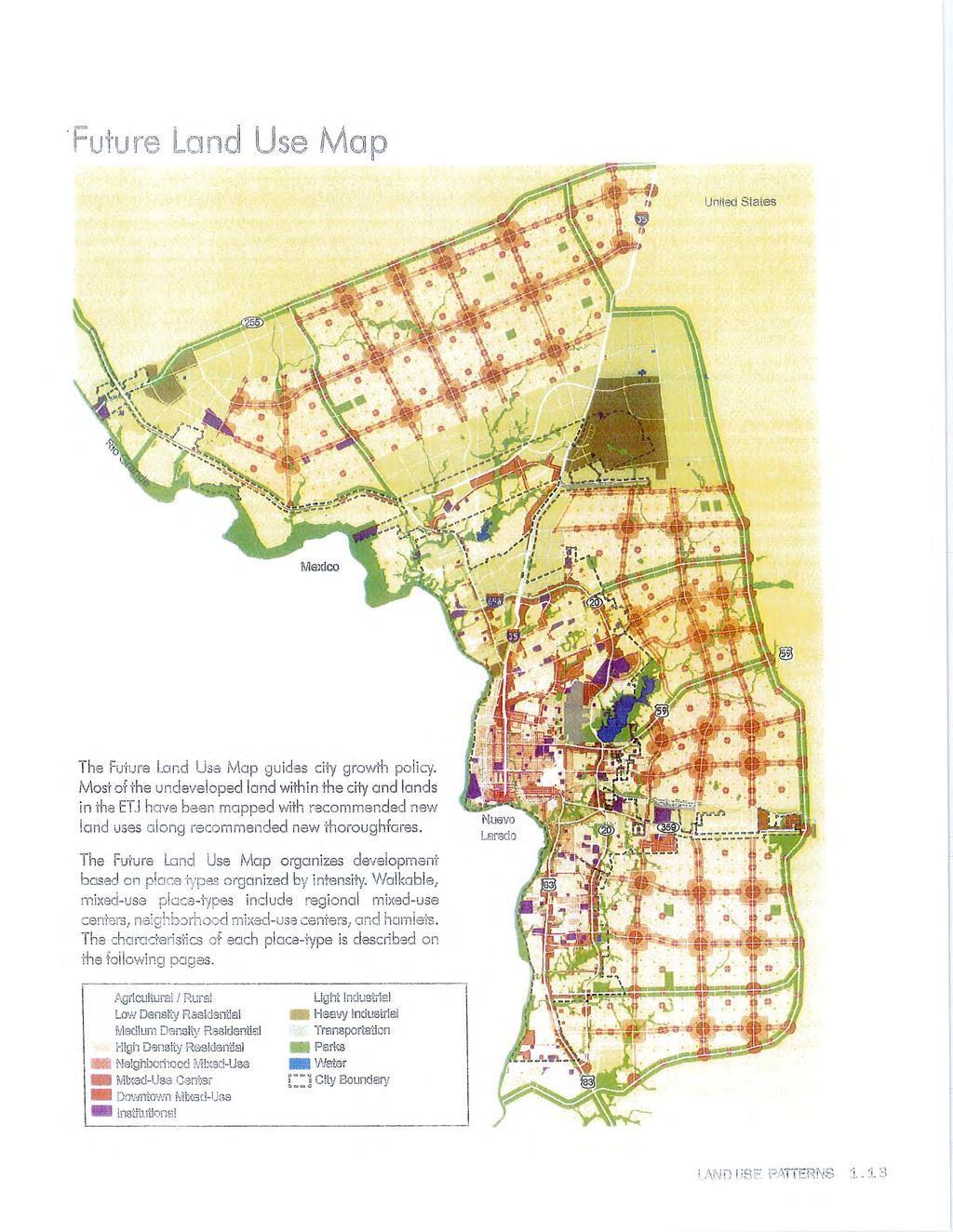
86
87
88
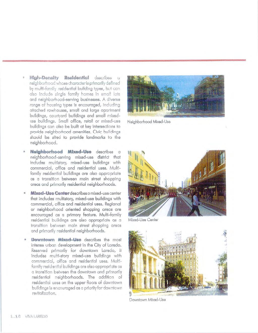
89
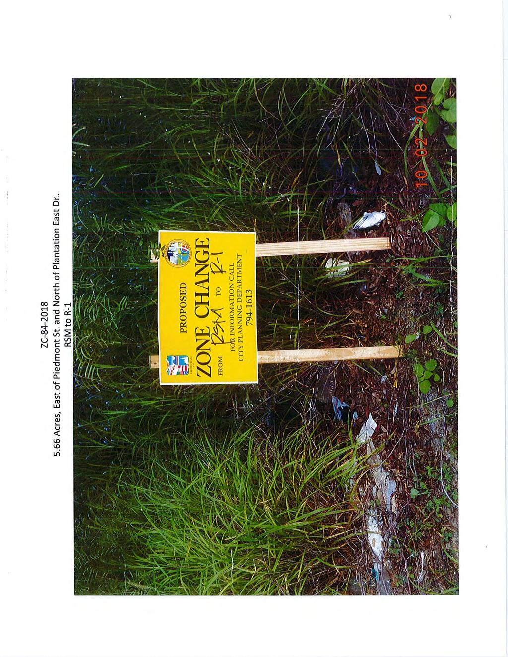
90
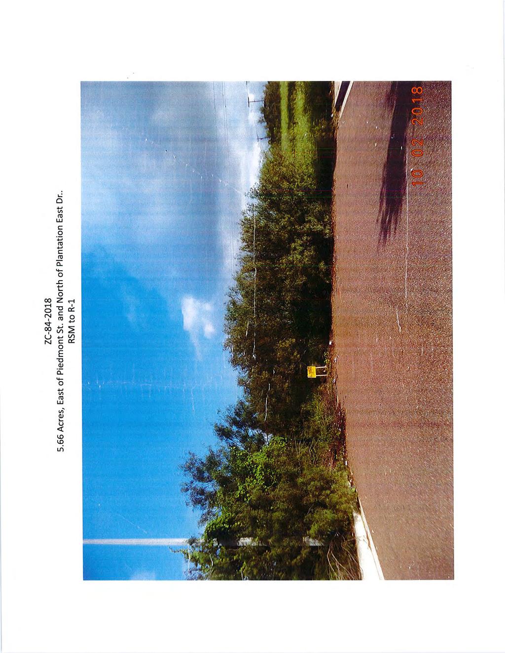
91
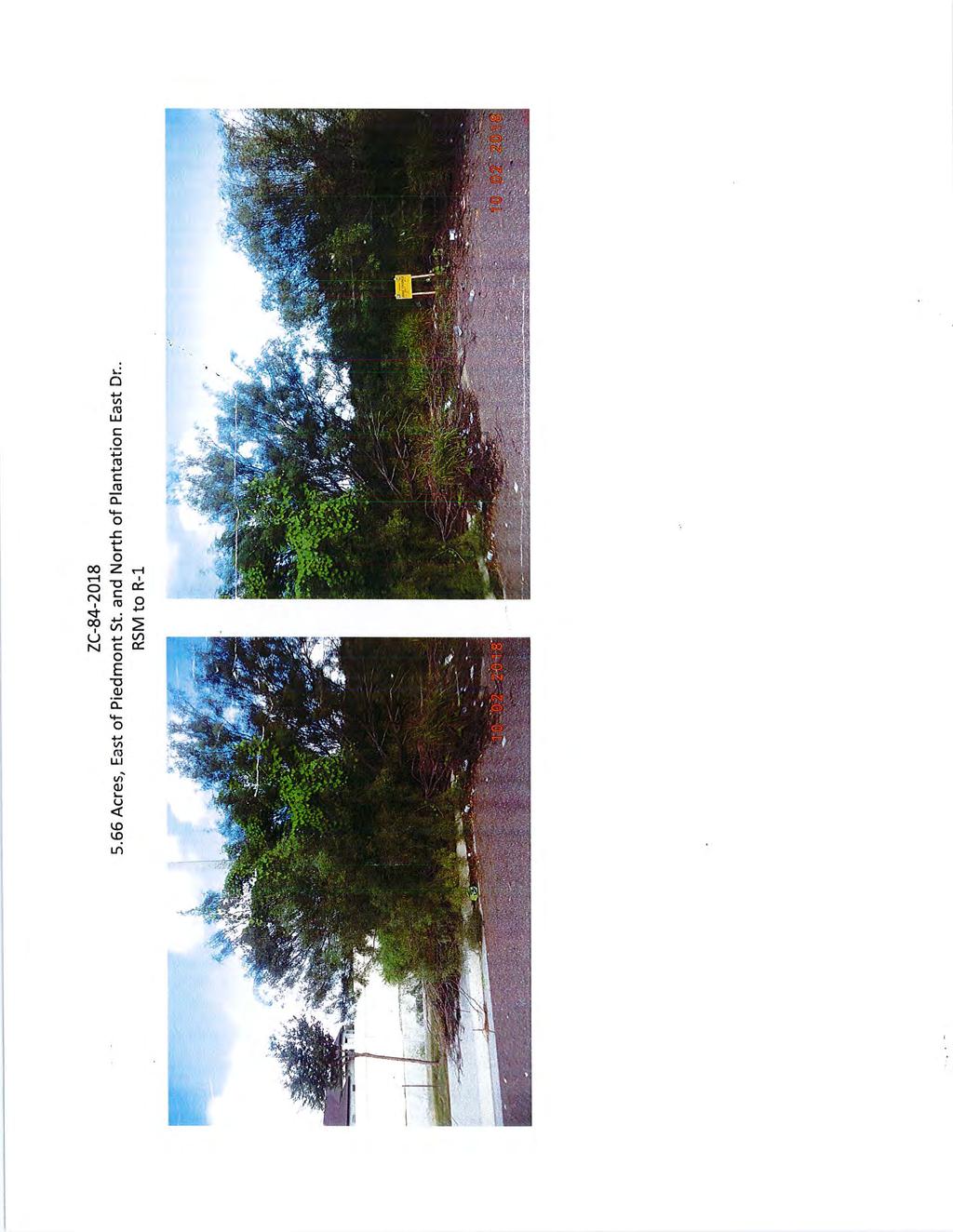
92
93
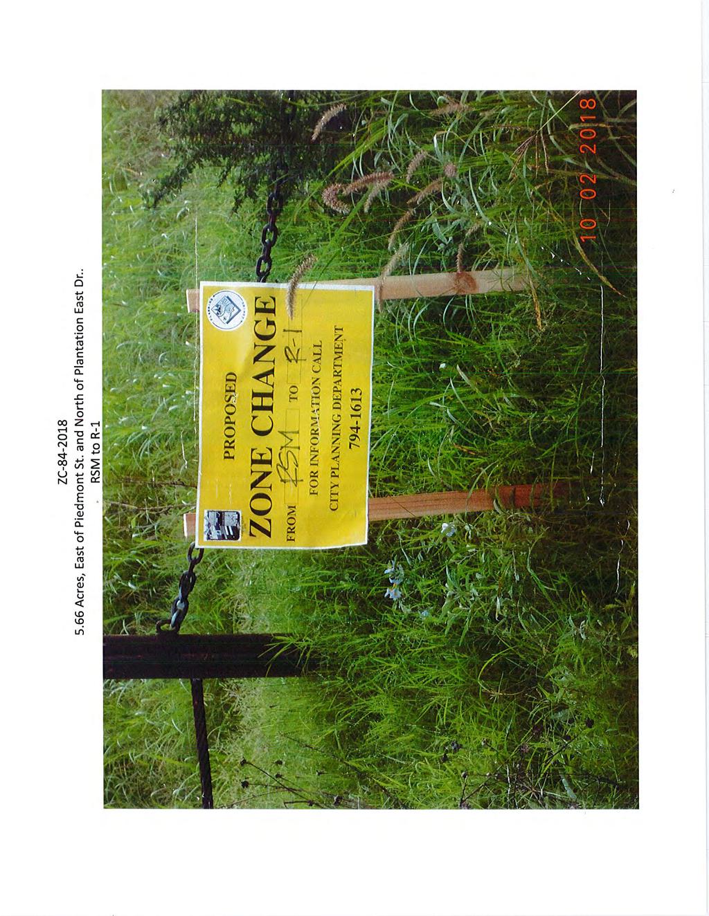
94
95
96
97
98
99 Planning and Zoning Commission- Regular 6. E. Meeting Date: 10/18/2018 Staff Source: Alejandrina Sanchez, Planner Initiated by: Acuatica Atlantis LLC/Patricia Mendiola, Owner/Applicant Prior Action: None. SUBJECT: Amending the Zoning Ordinance (Map) of the City of Laredo by rezoning Lot 1, Block 1, Trinity Plaza Subdivision, located at 1815 Shiloh Dr., from B-1 (Limited Business District) to B-3 (Community Business District). ZC District VI BACKGROUND: Council District: VI The Honorable Charlie San Miguel Proposed use: No specific use is proposed by applicant. Site: Aquademy Swim School Surrounding land uses: North, east and west of the property is raw undeveloped land. South of the property are single family residential uses. The property abuts R-1 district to the south. Comprehensive Plan: The Future Land Use Map recognizes this site as Low Density Residential. Transportation Plan: The Long Range Thoroughfare Plan identifies Shiloh Dr. as a Major Arterial. The Plan does not identify Backwoods Trl. Letters sent to surrounding property owners: 21 In Favor: 1 Opposed: 0 STAFF COMMENTS:
100 Staff does not support the zone change for the following reasons: 1. The proposed zone change is not in conformance with the new Comprehensive Plan s designation of this area as Low Density Residential. 2. The proposed zone change is not compatible with the residential uses in the area. 3. Applicant has not indicated a proposed use that would require the B-3 District. 4. The current B-1 zoning district allows for the present use (swimming pool). P&Z RECOMMENDATION: The P & Z Commission, in a _ to _ vote, recommends of the zone change. STAFF RECOMMENDATION: Staff does not support the proposed zone change. IMPACT ANALYSIS B-3 (Community Business District): The purpose of the B-3 District is to provide for those businesses and services serving a trade area larger than a neighborhood, but smaller than the entire city and located primarily along minor or principal arterial streets, as classified in the Transportation Plan of the City of Laredo. It is intended for this zoning classification to exist primarily abutting minor or principal arterial streets while preserving established residential neighborhoods along such streets. By rezoning from B-1 to B-3 all B-3 uses would be allowed in addition to all those under the B-1 zoning district. Some of the active uses that could be allowed are: hotel/motel funeral home, building materials sales, auto dealer new/used, upholstery shop, restaurant (drive thru), heavy machinery sales/display (inside) machinery sales/display (inside), pawn shop, portable buildings leasing/storage, portable chemical toilet leasing/storage, commercial parking lot, auto tire repair, tire sales (indoors), auto glass repair/tinting, car wash (self-service), commercial car wash (detail shop), quick lube/oil change,
101 bakery-wholesale, contractor s office/sales, parking areas for vehicles/trailers/rv s, amusement services (indoors), children s amusement services (outdoors), billiard parlor, etc. Is this change contrary to the established land use pattern? Yes, the established land use pattern in the area is single family residential. Would this change create an isolated zoning district unrelated to surrounding districts? Yes, there is no B-3 district in the area. The property abuts another B-1 district to the west and R-1 to the south. Will change adversely influence living conditions in the neighborhood? Yes, the proposed district may introduce more intense uses into the area, since there are adjacent residences. Are there substantial reasons why the property cannot be used in accord with existing zoning? No, the current district allows for the current use (Aquademy) and more commercial uses. Color Maps - ZC Color Pictures - ZC Attachments
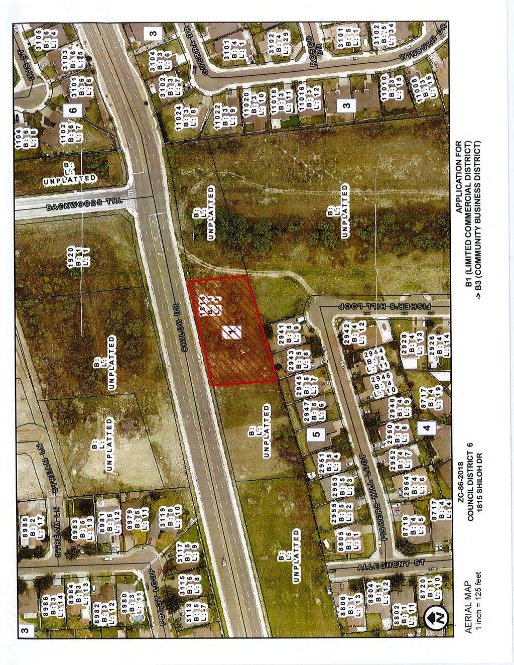
102
103
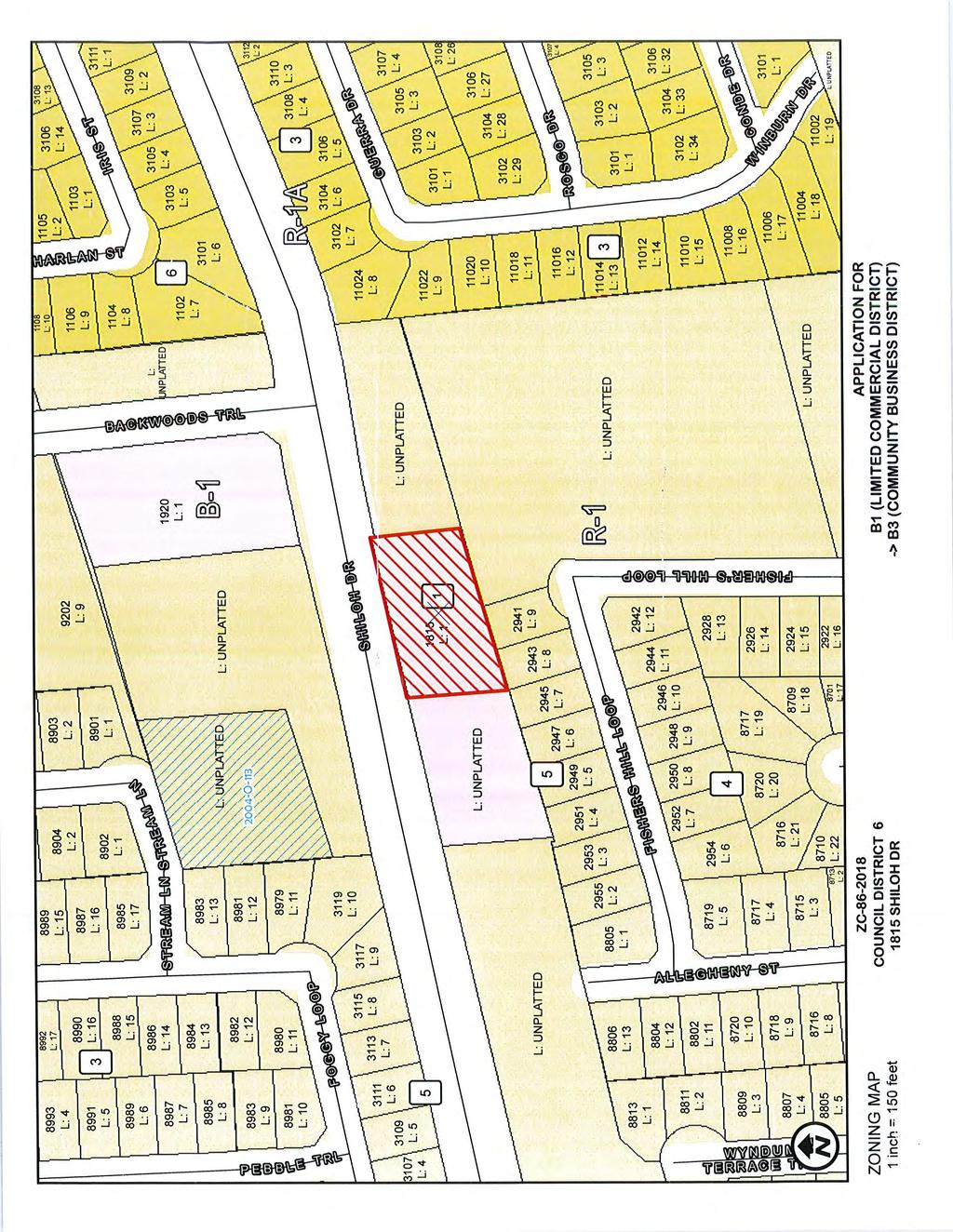
104
105
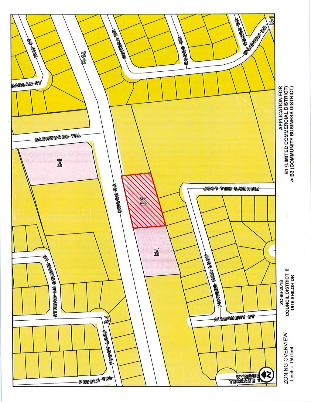
106
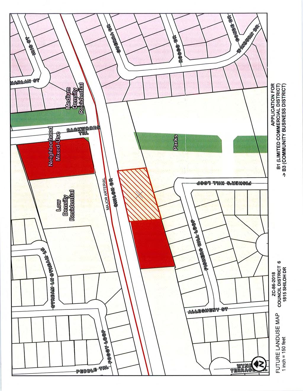
107
108
109
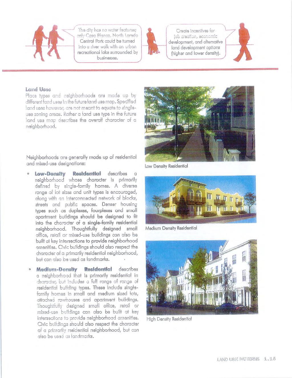
110
111
112
113
114
115
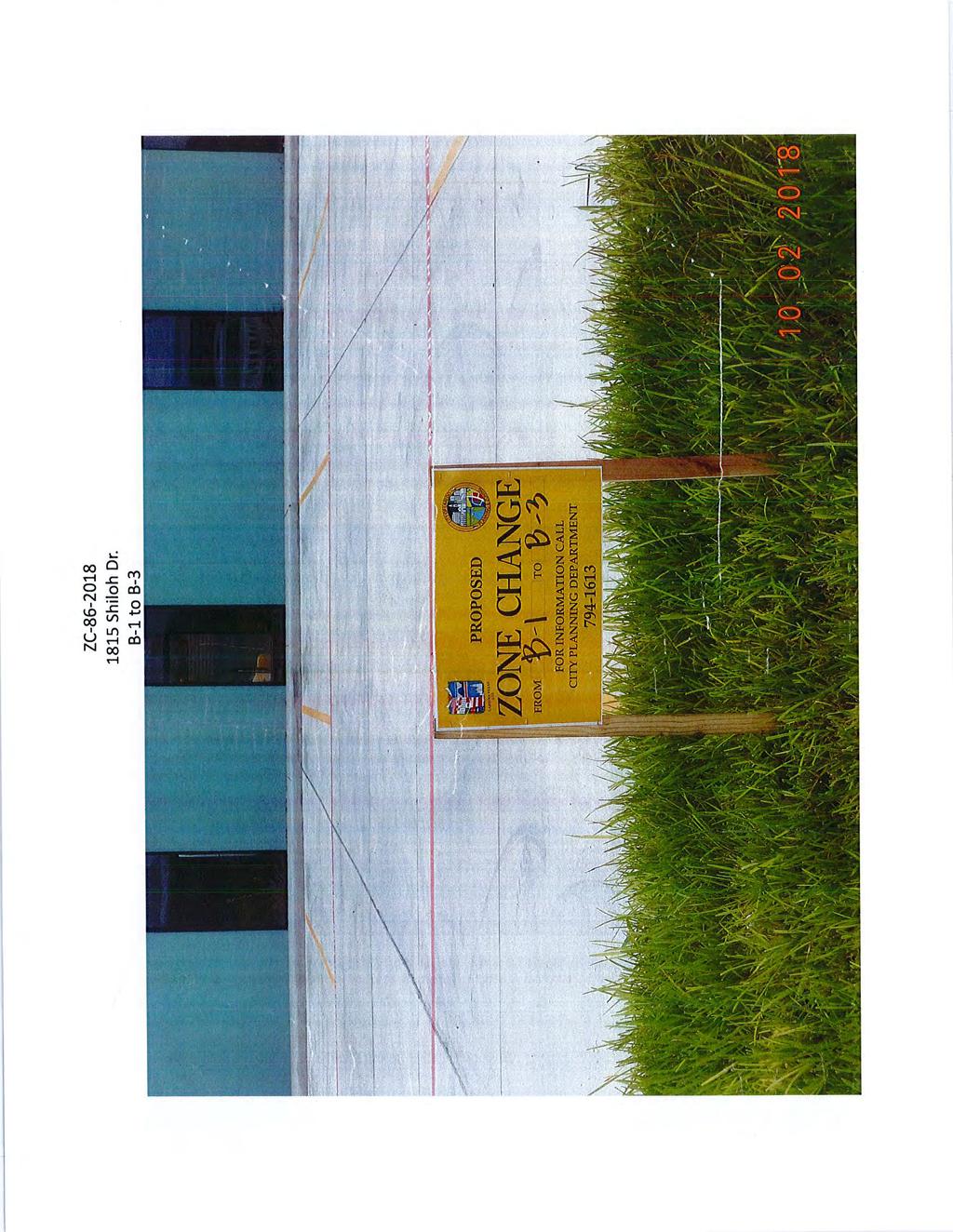
116
117
118
119 Planning and Zoning Commission- Regular 6. F. Meeting Date: 10/18/2018 Staff Source: Alejandrina Sanchez, Planner Initiated by: FSPJM Investments LLC/Felipe J. Vielma and Norma N. Vielma Owner(s)/Applicant(s) Prior Action: None. SUBJECT: Amending the Zoning Ordinance (Map) of the City of Laredo by rezoning Lot 4, Block 178, Western Division, located at 1007 San Dario Ave. from B-1 (Limited Business District) to B-4 (Highway Commercial District). ZC District VIII BACKGROUND: Council District: VIII The Honorable Roberto Balli Proposed use: Billboard Site: Office Building Surrounding land uses: North, of the property is Hwy. 35. North of the property there are Laredo Merchandize and Metro PC. East of the property there are single family residences. South of the property is Casa de Cambio. Comprehensive Plan: The Future Land Use Map recognizes this site as Neighborhood Mixed Use. Transportation Plan: The Long Range Thoroughfare Plan identifies Interstate 35 as a Freeway. The Plan does not identify San Dario Ave. but identifies Washington St., as an Industrial Collector. (North of the property). Letters sent to surrounding property owners: 13 In Favor: 0 Opposed: 0
120 STAFF COMMENTS: The proposed zone change is not appropriate at this location. Staff does not support the proposed zone change for the following reasons: 1. The proposed district is not consistent with the new Comprehensive Plan s designation for this property as Neighborhood Mixed Use (which includes most zoning groups, except M-1, M-2, B-4, AH, AN, FH, OG, and FiH. 2. Although the property does comply with the B-4 location (primarely along principal major arterials or the freeway); the property does not comply with the minimum B-4 lot size of 10,000 s.f. (The property is 8,708 s.f.). 3. Location abuts Single Family Residential Uses to the east. 4. There are not other B-4 zoning districts in the area. *Applicant needs to consider verifing distance requirements for the proposed Billboard with the Building Devepolment Services Department. P&Z RECOMMENDATION: The P & Z Commission, in a _ to _ vote, recommends of the zone change. STAFF RECOMMENDATION: Staff does not support the proposed zone change. IMPACT ANALYSIS B-4 (Highway Commercial District): The purpose of the B-4 District (Highway Commercial District) is to provide for those businesses and services serving a regional area which are to be located primarily along principal (major) arterial streets or the freeway, as classified in the Transportation Plan of the City of Laredo. It is intended for this zoning classification to exist primarily along principal arterial streets or the freeway and to impose site development regulations to ensure adequate access of all uses within this classification. Is this change contrary to the established land use pattern? No. The established land use pattern is light commercial and residential. Would this change create an isolated zoning district unrelated to surrounding districts? Yes. There is no B-4 zoning district in the area (East of Highway 35). Will change adversely influence living conditions in the neighborhood? No. The proposed use may impact negatively the existing conditions in the area, and fronting San Dario Ave., may introduce more noise and heavier traffic into the area.
121 Are there substantial reasons why the property cannot be used in accordance with existing zoning? No. The existing B-1 (Limited Business District) does allow for enough commercial uses. Color Maps - ZC Color Pictures - ZC Attachments
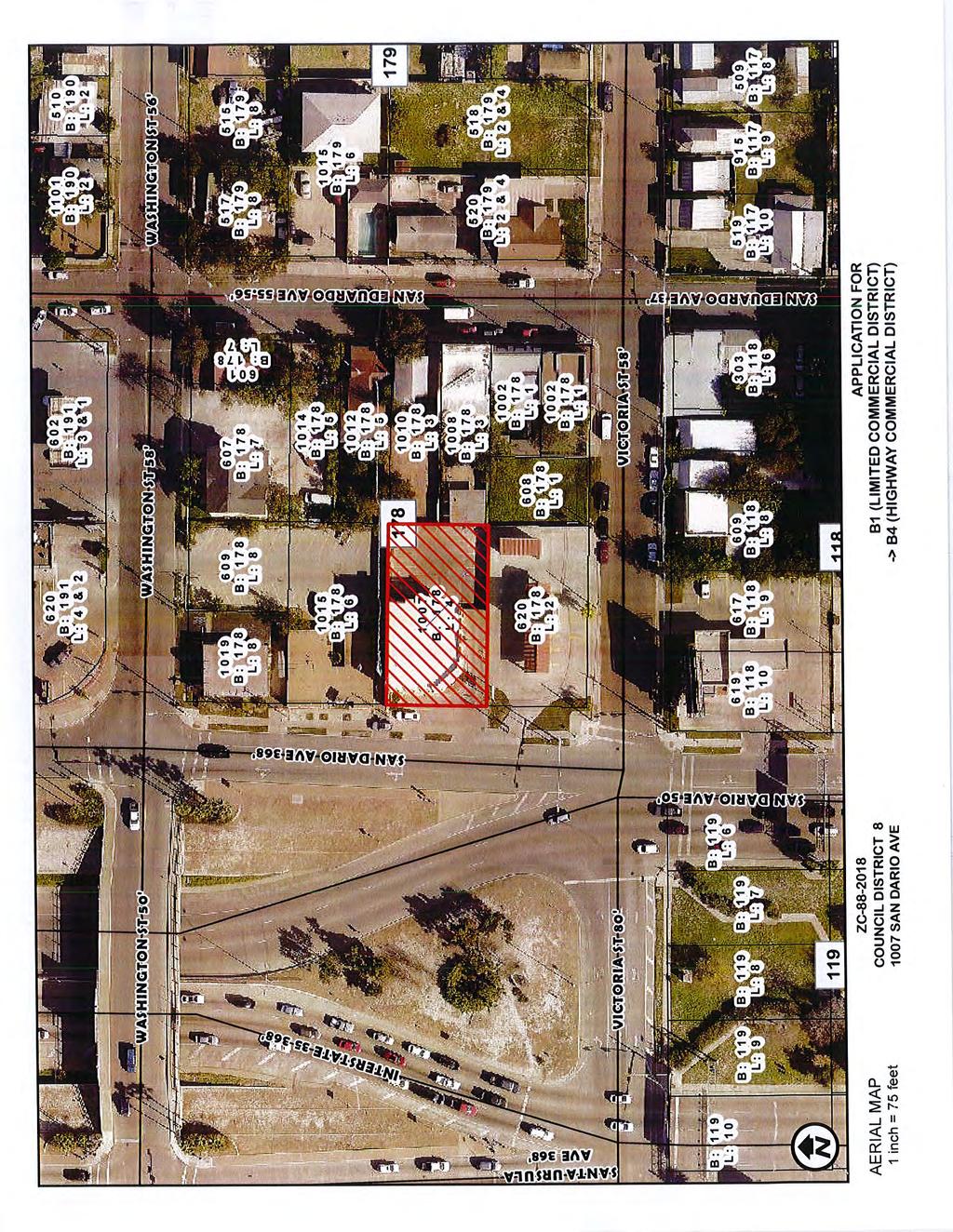
122
123
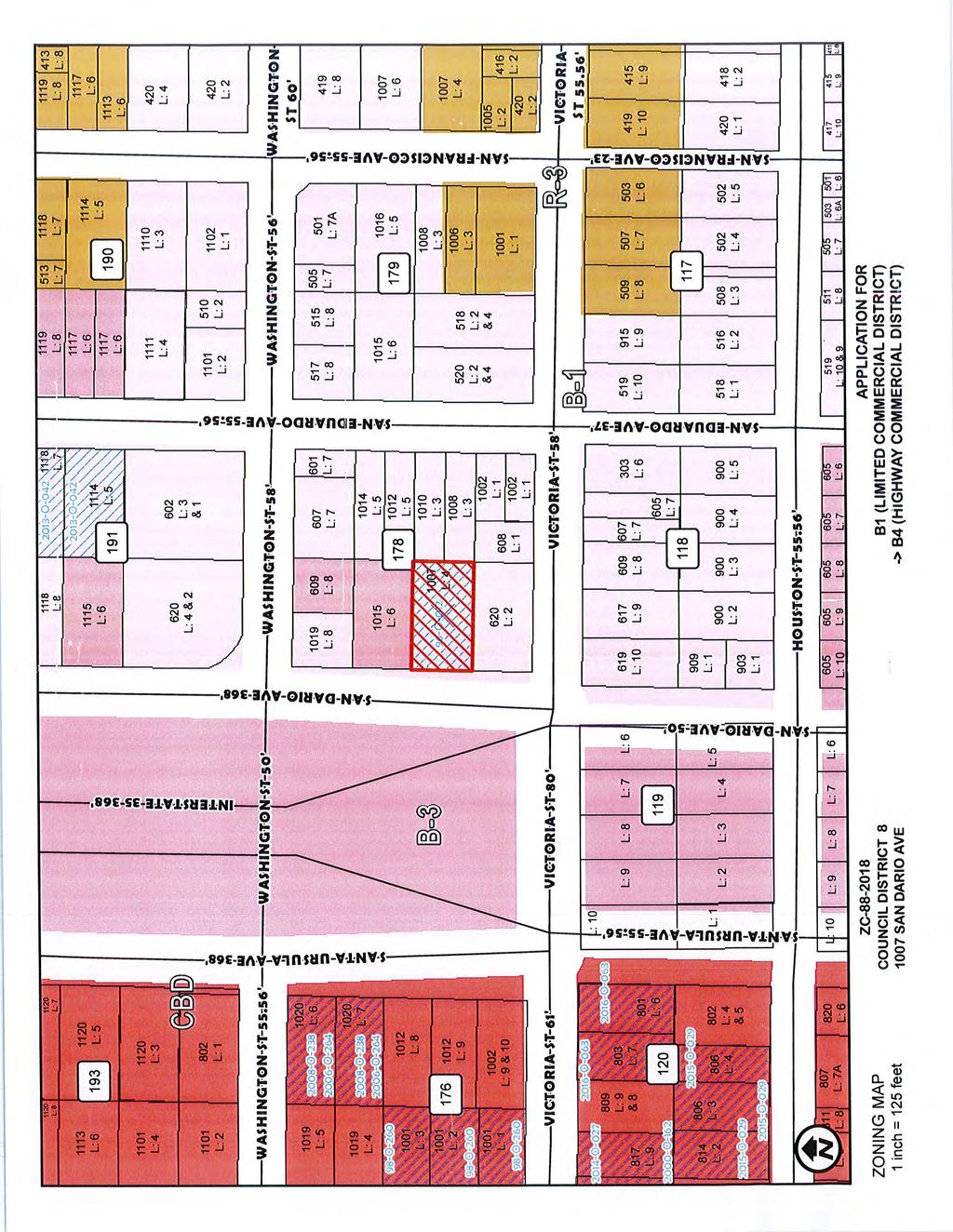
124
125
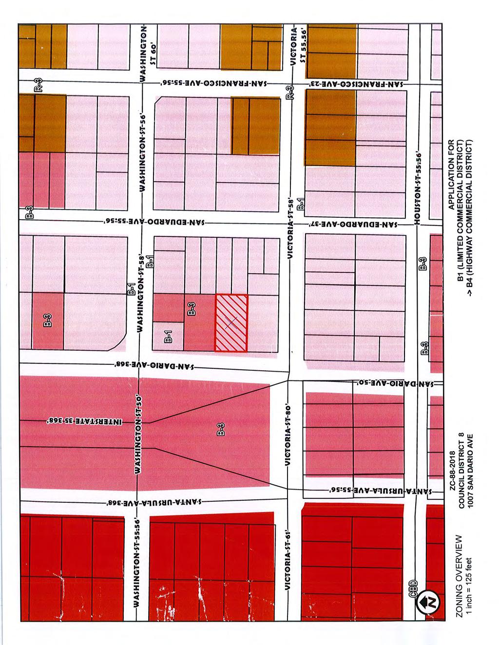
126
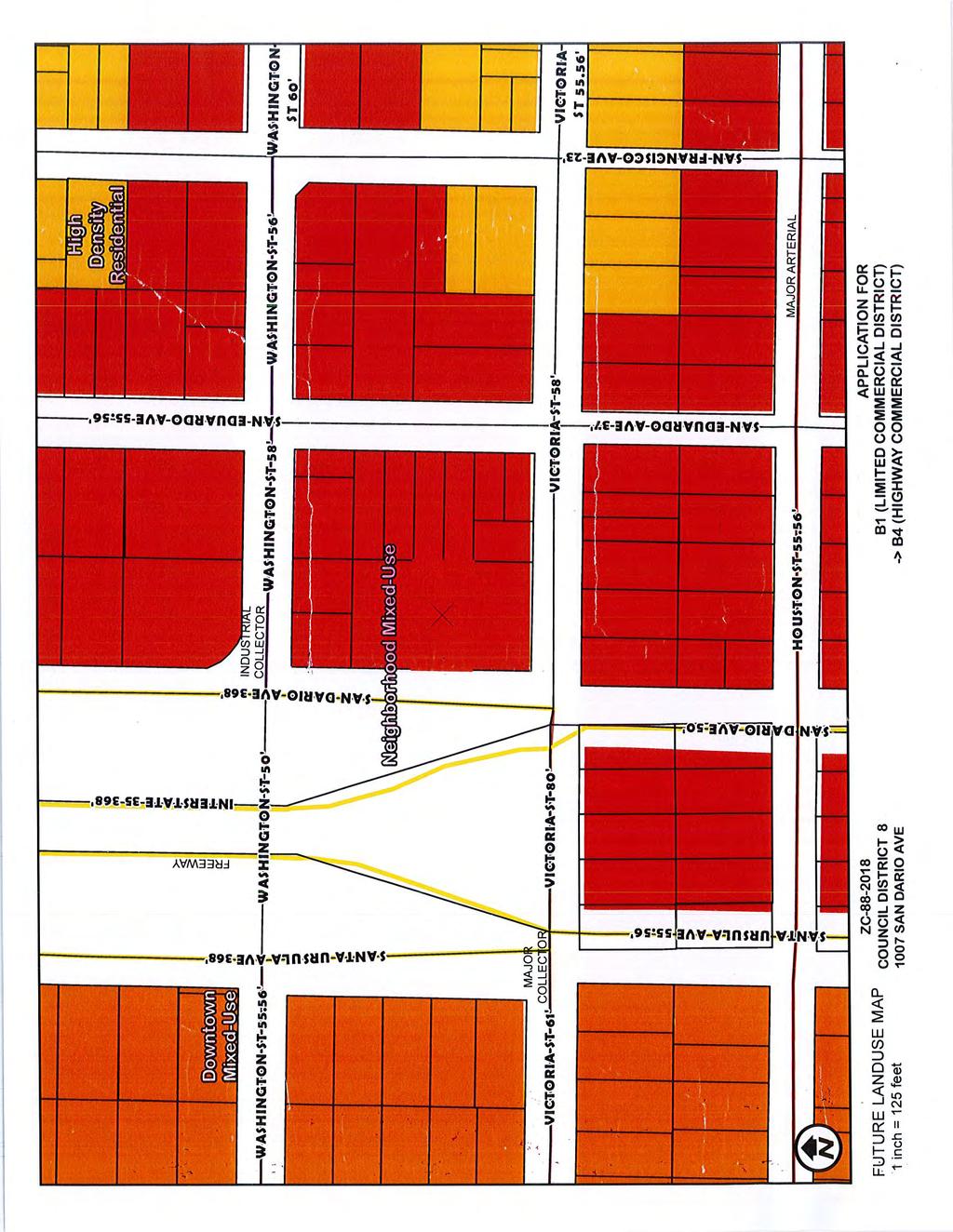
127
128
129
130
131
132
133
134
135
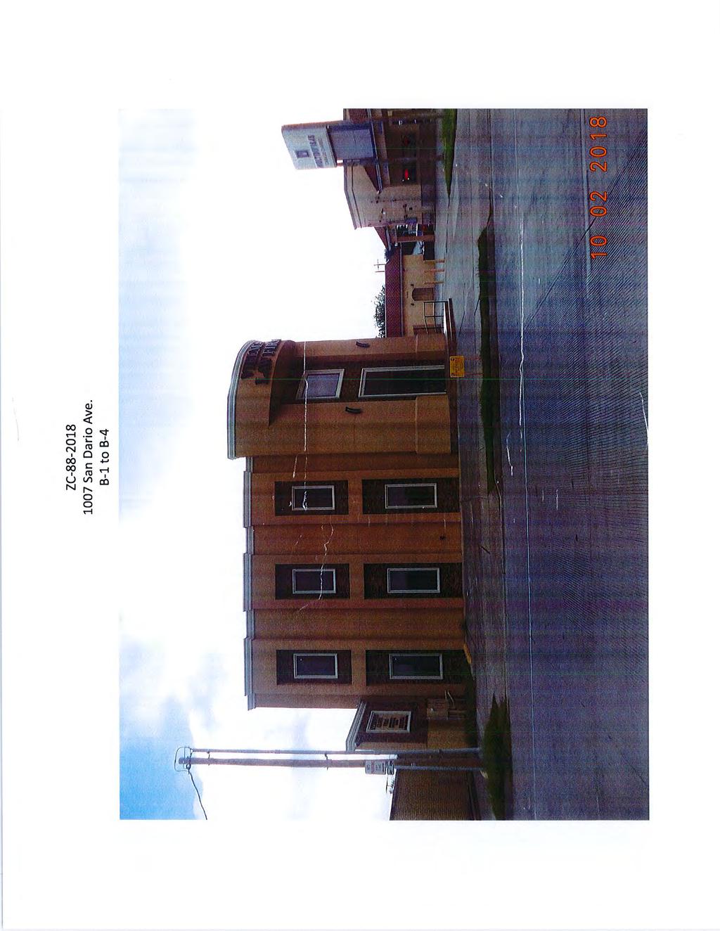
136
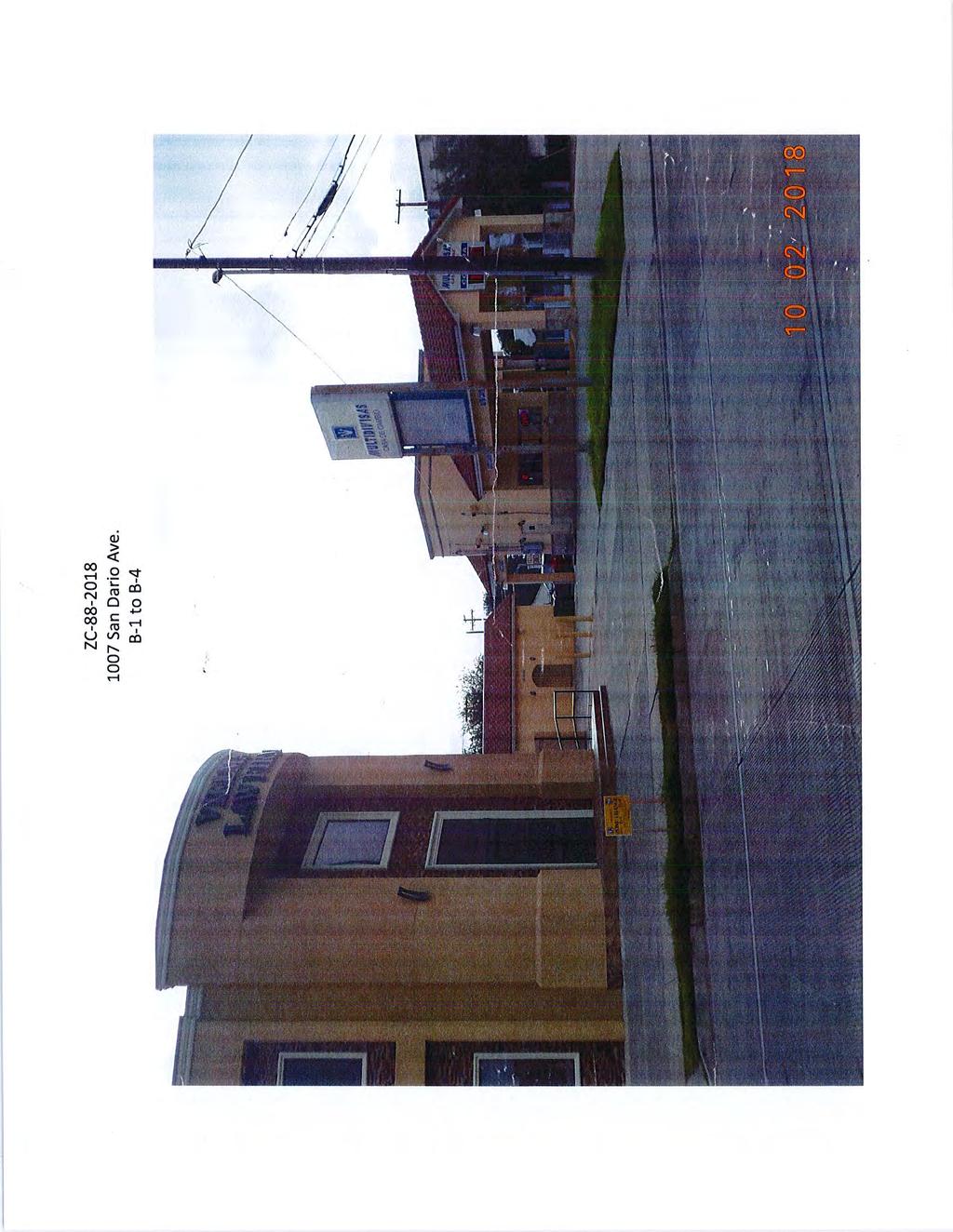
137
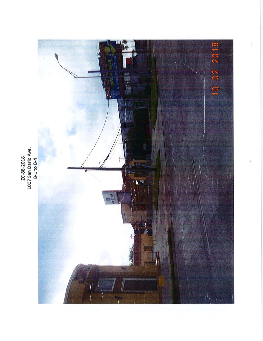
138
139 Planning and Zoning Commission- Regular Meeting Date: 10/18/2018 Staff Source: Karina L. Castillo, Planner APPLICANT: 4V Holdings, Ltd ENGINEER: Porras Nance Engineering Master Plans 7. A. REQUEST: Review and consideration of Cuatro Vientos East - Wright Ranch Subdivision Master Plan. The purpose of the update is to combine Phase III & Phase XI. The intent is residential. District I- Cm. Rudy Gonzalez Jr. SITE: This acre tract is located east of Cuatro Vientos Rd. and north of Worrnser Rd. The zoning for the 683 lot development is R-lA. This tract is located in District I- Cm. Rudy Gonzalez Jr. PROPOSED ACTION: APPROVE SUBJECT TO THE FOLLOWING COMMENTS: Planning: 1. Provide a plat note with X, Y coordinates for point of beginning and point of commencement. 2. Submit master plan revision to City of Laredo Building Department GIS Division within 10 days of commission approval in a geo-referenced CAD file in accordance to Section 2-3.2(a) 4 of the City of Laredo Subdivision Ordinance. 3. All improvements as Per Subdivision Ordinance. Engineering: No comments submitted. Fire: No comments submitted. Environmental: No comments submitted. Water & Utilities: 1. The engineer has to provide Water Master Plan with water consumption calculations and Sanitary Sewer discharge calculations and the total flow directed to the
140 Vaquillas Lift Station. LUE's for water and sewer apply. Traffic Safety: 1. Some streets will need calming devices 2. There is some sight distance on proposed road that connects with Loop 20 and the entrance to Phase IV. 3. There isn't any collector to connect north to south. Parks & Leisure: No comments submitted. WEBB County App: No comments submitted. AEP Engineers: No comments submitted. U.I.S.D.: No comments submitted. L.I.S.D.: No comments submitted. AT&T: No comments submitted. NOTICE TO THE DEVELOPER: Planning: 1. Only the utility easements within the plat boundaries are subject to change prior to plat recordation, due to revisions by the utility companies. Attachments Vicinity Map Cuatro Vientos East - Wright Master Plan
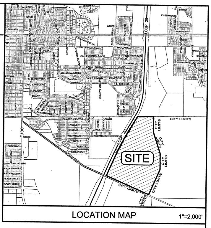
141
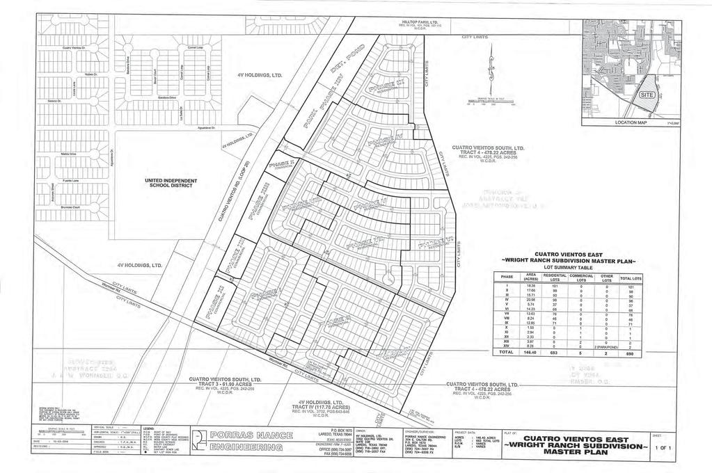
142
143 Planning and Zoning Commission- Regular Meeting Date: 10/18/2018 Staff Source: Karina L. Castillo, Planner APPLICANT: Maxopress Properties, Inc. ENGINEER: Guerra Engineering & Surveying Co. Master Plans 7. B. REQUEST: Review and consideration of Maxopress Properties Subdivision Master Plan. The intent is residential and commercial. District II - Cm. Vidal Rodriguez SITE: This 2 acre tract is located north of SH 359 and east of Serrano Rd. The zoning for the 2 lot development is R-3. This tract is located in District II - Cm. Vidal Rodriguez. Phase II is located outside the City Limits but within the City of Laredo s ETJ (Extra Territorial Jurisdiction). PROPOSED ACTION: APPROVE SUBJECT TO THE FOLLOWING COMMENTS: Planning: 1. Provide a plat note with X, Y coordinates for point of beginning and point of commencement. 2. Submit master plan revision to City of Laredo Building Department GIS Division within 10 days of commission approval in a geo-referenced CAD file in accordance to Section 2-3.2(a) 4 of the City of Laredo Subdivision Ordinance. 3. Correctly label what is shown as "Tex-Mex Access Rd." to be label as "Serrano Rd." 4. Correctly label what is shown as "Serrano Rd." to be labeled as an access easement which is located outside the city limits. 5. Correct the current city limit boundary on plat and vicinity map. 6. All improvements as per Subdivision Ordinance. Engineering: No comments submitted. Fire: No comments submitted. Environmental: No comments submitted.
144 Water & Utilities: 1. After the whole property has been annexed, fractions of it can be platted provided they have water and sewer connections. Traffic Safety: No comments submitted. Parks & Leisure: No comments submitted. WEBB County App: No comments submitted. AEP Engineers: No comments submitted. U.I.S.D.: No comments submitted. L.I.S.D.: No comments submitted. AT&T: No comments submitted. NOTICE TO THE DEVELOPER: Planning: 1. Only the utility easements within the plat boundaries are subject to change prior to plat recordation, due to revisions by the utility companies. Vicinity Map Maxopress Properties Master Plan Attachments
145
146
147 Planning and Zoning Commission- Regular Meeting Date: 10/18/2018 Staff Source: Karina L. Castillo, Planner APPLICANT: 4V Holdings, Ltd ENGINEER: Porras Nance Engineering Preliminary Plats/Replats 8. A. REQUEST: Preliminary consideration of the Plat of Cuatro Vientos East Wright Ranch Subdivision Phase III. The intent is residential. District I - Rudy Gonzalez. Jr. SITE: This acre tract is located north of Wormser Rd. and east of Cuatro Vientos Rd. The zoning for this 90 lot development is R-1A. This tract is located in District I - Rudy Gonzalez. Jr. PROPOSED ACTION: APPROVE SUBJECT TO THE FOLLOWING COMMENTS: Planning: 1. Label CP&L easement as a "No Build Zone." 2. Submit a written notice of the developer s intention to place front of lot utilities. 3. Connect the font of lot utility easements to the front setbacks. 4. All improvements as per Subdivision Ordinance. Engineering: No comments submitted. Fire: No comments submitted. Environmental: No comments submitted. Water & Utilities: 1. This project pays for Water Availability, Annexation, and LUE's for Water and Sewer. Traffic Safety: 1. Is Wormser Rd. open?
148 2. There isn't any collector that connects north and south. Parks & Leisure: No comments submitted. WEBB County App: No comments submitted. AEP Engineers: No comments submitted. U.I.S.D.: No comments submitted. L.I.S.D.: No comments submitted. AT&T: No comments submitted. NOTICE TO THE DEVELOPER: Planning: 1. Only the utility easements within the plat boundaries are subject to change prior to plat recordation, due to revisions by the utility companies. 2. All comments set forth herein are preliminary comments and not an exhaustive list. Additional comments may be added prior to final plat approval. Attachments Vicinity Map Plat Notes Cuatro Vientos East - Wright Phase III
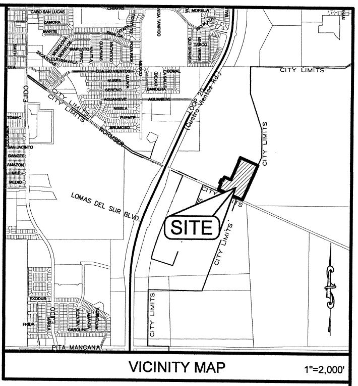
149
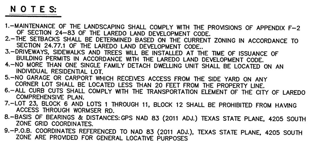
150
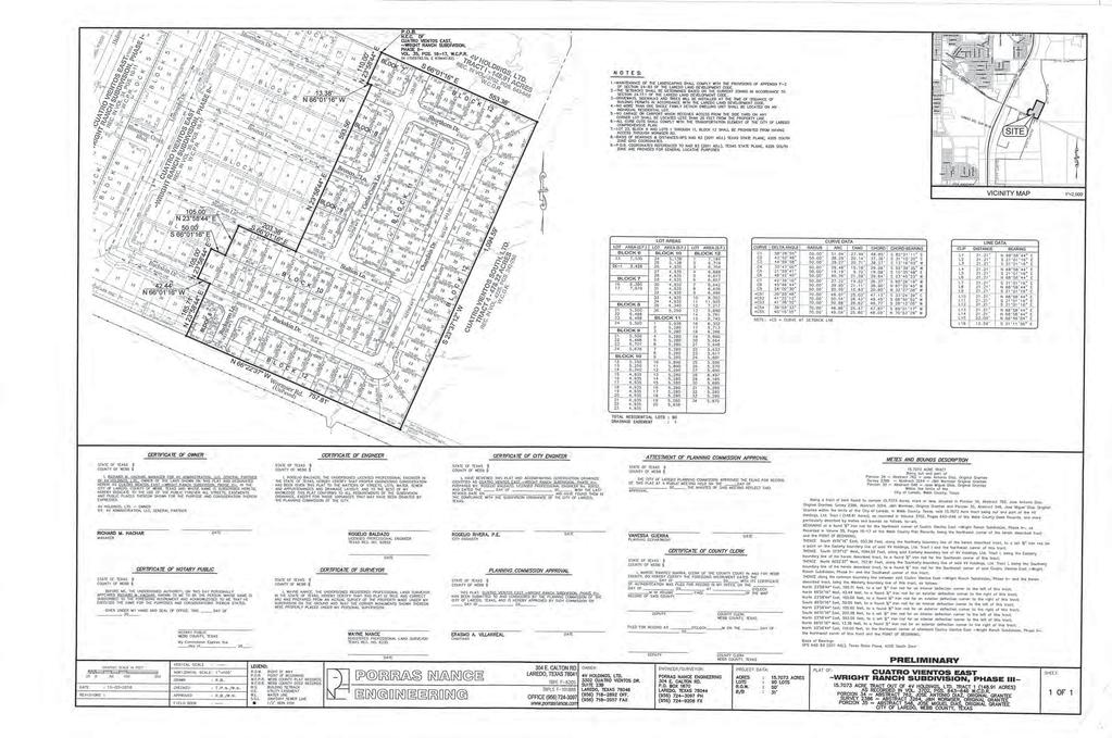
151
152 Preliminary Plats/Replats 8. B. Planning and Zoning Commission- Regular Meeting Date: 10/18/2018 Staff Source: Karina L. Castillo, Planner APPLICANT: Maxopress Properties, Inc. ENGINEER: Guerra Engineering & Surveying Co. REQUEST: Preliminary consideration of the Plat of Maxopress Properties Subdivision Phase I. The intent is residential and commercial. District I- Cm. Vidal Rodriguez. SITE: This acre tract is located north of SH 359 and east of Serrano Rd. The zoning for the 1 lot development is R-3. This tract is located in District I- Cm. Vidal Rodriguez. PROPOSED ACTION: APPROVE SUBJECT TO THE FOLLOWING COMMENTS: Planning: 1. Correctly label what is shown as "Tex-Mex Access Rd." to be label as "Serrano Rd." Correctly label what is shown as "Serrano Rd." to be labeled as an access easement which is located outside the city limits. Correct the current city limit boundary on plat and vicinity map. 2. Remove dates from signature blocks. 3. Revise Attestment of Planning Approval signature line to say "Vanessa Guerra, Planning Department." 4. All improvements as per Subdivision Ordinance. Engineering: No comments submitted. Fire: No comments submitted. Environmental: No comments submitted. Water & Utilities: 1. This project cannot be platted just the front part. The whole property has to be annexed.
153 Traffic Safety: No comments submitted. Parks & Leisure: No comments submitted. WEBB County App: No comments submitted. AEP Engineers: No comments submitted. U.I.S.D.: No comments submitted. L.I.S.D.: No comments submitted. AT&T: No comments submitted. NOTICE TO THE DEVELOPER: Planning: 1. Only the utility easements within the plat boundaries are subject to change prior to plat recordation, due to revisions by the utility companies. 2. All comments set forth herein are preliminary comments and not an exhaustive list. Additional comments may be added prior to final plat approval. Vicinity Map Plat Notes Maxopress PropertiesPhase I Attachments
154
155
156
157 Planning and Zoning Commission- Regular Meeting Date: 10/18/2018 Staff Source: Karina L. Castillo, Planner APPLICANT: Killam Development, LTD. ENGINEER: Howland Engineering & Surveying Co. Final Plats/Replats 9. A. REQUEST: Consideration of an extension of the final plat approval of the Plat of Winfield Phase 9A & 9B. The intent is residential. District VI - Cm. Charlie San Miguel SITE: This acre tract is located north of Winfield Parkway and west of Bob Bullock Loop. The zoning for this 1 lot development is R -1. This tract is located in District VI- Cm. Charlie San Miguel PROPOSED ACTION: APPROVAL. Vicinity Map Plat Notes Winfield Phase 9A & 9B Attachments
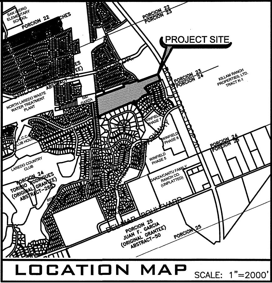
158
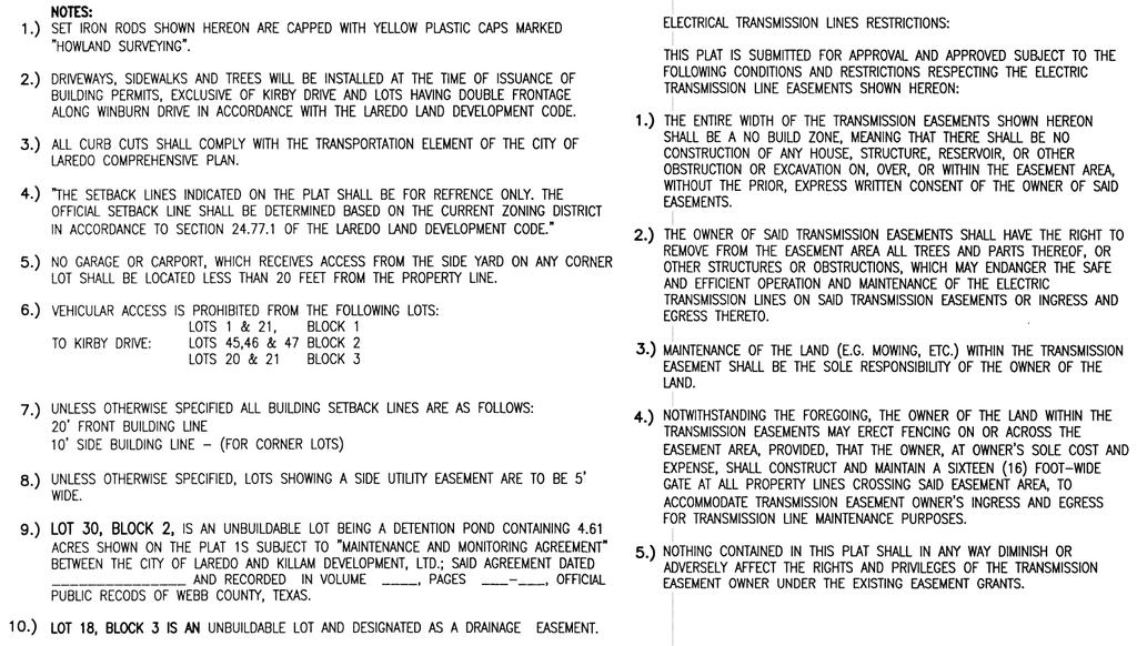
159
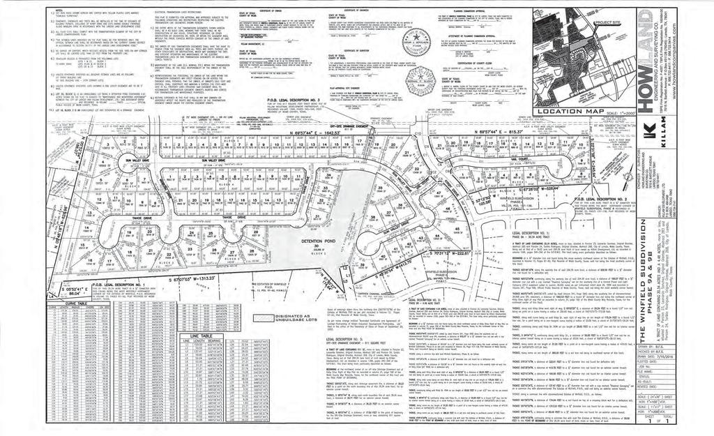
160
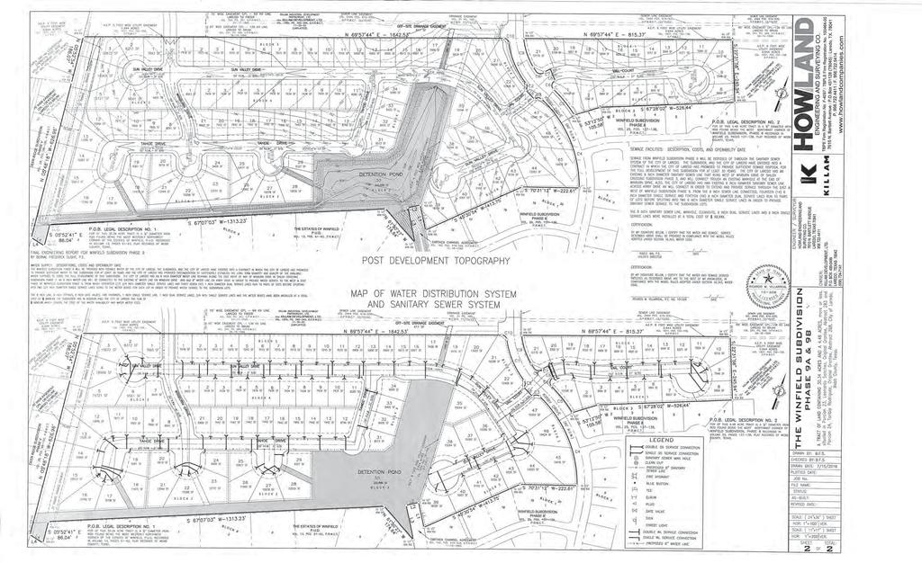
161
162 Final Plats/Replats 9. B. Planning and Zoning Commission- Regular Meeting Date: 10/18/2018 Staff Source: Karina L. Castillo, Planner APPLICANT: Webb Commercial Development, Inc. ENGINEER: Howland Engineering and Surveying Co. REQUEST: Consideration of an extension of the final plat approval of the Plat of Webb Industrial Park Phase III. The intent is industrial. District VII - George Altgelt SITE: This acre tract is located south of Beltway Pkwy. and west of IH 35. The zoning for this 19 lot development is AG. This tract is located in District VII - George Altgelt. PROPOSED ACTION: APPROVAL. Vicinity Map Plat Notes North Webb Industrial Park Phase III Attachments
163
164
165
166
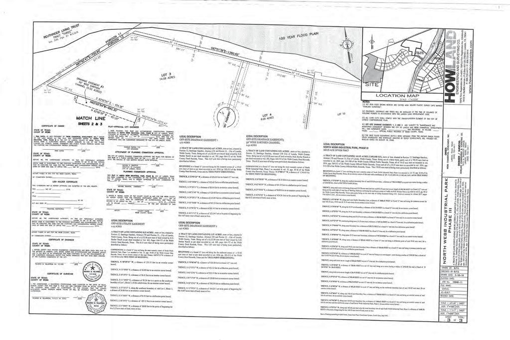
167
168 Model Subdivision Compliance 10. A. Planning and Zoning Commission- Regular Meeting Date: 10/18/2018 Staff Source: Karina L. Castillo, Planner APPLICANT: ALS Laredo Holding, LLC ENGINEER: Sherfey Engineering Company, L. L. C. REQUEST: Consideration of the Model Subdivision Rule Compliance of the Plat of Lomas del Sur Subdivision Unit XV. The intent is residential. SITE: This 8.92 acre tract is located north of Lomas Del Sur Blvd. and east of Ejido Ave. The zoning for this 53 lot development is R-1A. This tract is located in District I- Cm. Rudy Gonzalez, Jr. PROPOSED ACTION: APPROVAL. Vicinity Map Plat Notes Lomas del Sur Phase XV Attachments
169
170
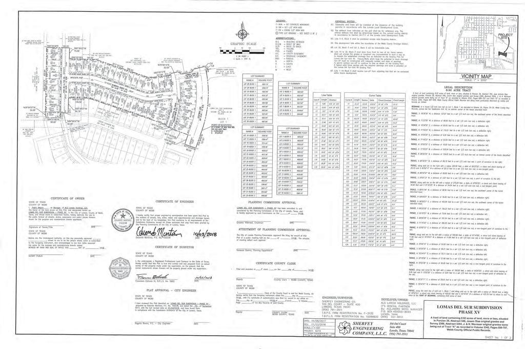
171
PLANNING AND ZONING COMMISSION
 PLANNING AND ZONING COMMISSION NOTICE OF PUBLIC MEETING City of Laredo City Hall City Council Chambers 1110 Houston Street Laredo, Texas September 20, 2018 6:00 p.m. MEETING AGENDA 1. CALL TO ORDER - :.
CITY OF LAREDO PLANNING AND ZONING COMMISSION
 CITY OF LAREDO PLANNING AND ZONING COMMISSION MINUTES OF THE PLANNING AND ZONING MEETING OF FEBRUARY 15, 2017 The City of Laredo Planning and Zoning Commission convened in special session open to the public
7. CONSIDERATION OF THE FOLLOWING PRELIMINARY PLATS AND PRELIMINARY REPLATS:
 A. Review and reconsideration of the Eleden Subdivision Master Plan. The intent is residential and commercial. The purpose of this revision is to create two phases out of one phase and to remove the extension
AGENDA ITEM: VIII-A DATE: 04/06/17 APPLICANT: AR Sanchez, Jr. ENGINEER: Crane Engineering REQUEST: Review and consideration of the Southern Developmen
 AGENDA ITEM: VIII-A DATE: 04/06/17 APPLICANT: AR Sanchez, Jr. ENGINEER: Crane Engineering REQUEST: Review and consideration of the Southern Development Subdivision Master Plan. The intent is residential
PLANNING AND ZONING COMMISSION
 PLANNNG AND ZONNG COMMSSON NOTCE OF PUBLC MEETNG City of Laredo City Hall City Council Chambers 1ll0 Houston Street Laredo, Texas September 1, 2016 6:00p.m. AMENDED MEETNG AGENDA. CALL TO ORDER.. V. ROLL
CITY OF LAREDO SPECIAL CITY COUNCIL MEETING
 CITY OF LAREDO SPECIAL CITY COUNCIL MEETING A-2014-SC-01 CITY COUNCIL CHAMBERS 1110 HOUSTON STREET LAREDO, TEXAS 78040 MAY 27, 2014 12:00 NOON DISABILITY ACCESS STATEMENT Persons with disabilities who
Planning & Zoning Commission
 Planning & Zoning Commission Planning & Development Department August 14, 01 Zoning Map Amendment MAP-1-0001 (Bay View Section 4) Request Rezone approximately 1.19 acres from OS (Open Space) to RSF- (Residential
SANTA FE BOARD OF COUNTY COMMISSIONERS. REGULAR MEETING (Public Hearing) May 13, :00 pm. Please turn off Cellular Phones during the meeting.
 May 13, :00 pm. Please turn off Cellular Phones during the meeting.") SANTA FE BOARD OF COUNTY COMMISSIONERS COMMISSION CHAMBERS COUNTY ADMINISTRATION BUILDING ===================================================================== REGULAR MEETING (Public Hearing) May 13,
SANTA FE BOARD OF COUNTY COMMISSIONERS COMMISSION CHAMBERS COUNTY ADMINISTRATION BUILDING ===================================================================== REGULAR MEETING (Public Hearing) May 13,
ACTION FORM BRYAN CITY COUNCIL
 ACTION FORM BRYAN CITY COUNCIL DATE OF COUNCIL MEETING: July 8, 2014 DATE SUBMITTED: June 17, 2014 DEPARTMENT OF ORIGIN: Development Services SUBMITTED BY: Maggie Dalton MEETING TYPE: CLASSIFICATION: ORDINANCE:
PLANNING AND ZONING COMMISSION AGENDA
 PLANNING AND ZONING COMMISSION AGENDA Regular Meeting Tuesday, March 10, 2015 7:00 p.m. City Hall - Council Chamber Daniel P. Moore Community Center Complex 1900 Billy G. Webb Drive Portland, Texas 1.
VILLAGE OF DOWNERS GROVE PLAN COMMISSION VILLAGE HALL COUNCIL CHAMBERS 801 BURLINGTON AVENUE. June 2, :00 p.m. AGENDA
 VILLAGE OF DOWNERS GROVE PLAN COMMISSION VILLAGE HALL COUNCIL CHAMBERS 801 BURLINGTON AVENUE June 2, 2014 7:00 p.m. AGENDA 1. Call to Order 2. Roll Call a. Pledge of Allegiance 3. Approval of Minutes April
PLANNING AND ZONING COMMISSION MARCH 28, 2018 CITY HALL S COUNCIL 5:00 P.M.
 PLANNING AND ZONING COMMISSION MARCH 28, 2018 CITY HALL S COUNCIL CHAMBERS @ 5:00 P.M. P&Z PRESENT P&Z ABSENT STAFF PRESENT GUESTS PRESENT Ned Sheats Julio Cerda Jaime Acevedo Carlos Chapa John R. Guerra
AGENDA BURLESON PLANNING AND ZONING COMMISSION February 10, 2015 BURLESON CITY HALL 141 W. RENFRO BURLESON, TX 76028
 AGENDA BURLESON PLANNING AND ZONING COMMISSION BURLESON CITY HALL 141 W. RENFRO BURLESON, TX 76028 REGULAR SESSION 6:00 p.m. Call to Order Invocation Pledge of Allegiance 1. Consent Agenda All items listed
MINUTES PLANNING AND ZONING COMMISSION FEBRUARY 9, 2016 REGULAR MEETING
 MINUTES PLANNING AND ZONING COMMISSION FEBRUARY 9, 2016 REGULAR MEETING The Planning and Zoning Commission conducted its February 9, 2016, Regular Meeting in the Council Chambers of City Hall (1900 Billy
THE AREA PLAN COMMISSION OF ST. JOSEPH COUNTY, IN AGENDA
 THE AREA PLAN COMMISSION OF ST. JOSEPH COUNTY, IN AGENDA Tuesday, June 20, 2017 Fourth-Floor Council Chambers 3:30 p.m. County-City Building, South Bend, IN PUBLIC HEARINGS: 1. Rezonings: A. A combined
Planning & Zoning Commission 3. a. Meeting Date: 07/09/2014 Submitted By: Amelia Moreno, Administration
 Planning & Zoning Commission 3. a. Meeting Date: 07/09/2014 Submitted By: Amelia Moreno, Administration Information SUBJECT: Approval of Planning and Zoning Meeting Minutes BACKGROUND: n/a DISCUSSION:
Staff Report: Date: Applicant: Property Identification: Acreage of Request: Current Zoning of Requested Area: Requested Action: Attached:
 Staff Report: Completed by Jeff Palmer Director of Planning & Zoning Date: November 7, 2018, Updated November 20, 2018 Applicant: Greg Smith, Oberer Land Developer agent for Ronald Montgomery ET AL Property
PLAN COMMISSION Wednesday, August 30, 2017
 PLAN COMMISSION Wednesday, August 30, 2017 (Plan Commission Meeting will convene at the conclusion of the 7:00 P.M. Joint Plan Commission and Zoning Board of Appeals Meeting) Lorraine H. Morton Civic Center,
A G E N D A. Planning & Zoning Commission City Council Chambers 800 Municipal Drive July 16, 2015, at 3:00 p.m.
 A G E N D A Planning & Zoning Commission City Council Chambers 800 Municipal Drive July 16, 2015, at 3:00 p.m. Item Page 1 Call Meeting to Order 2 Approval of the Agenda 3 Approval of the Minutes of the
SECTION 10.7 R-PUD (RESIDENTIAL PLANNED UNIT DEVELOPMENT) ZONE
 ZONE") Article X Zones 10-20 SECTION 10.7 R-PUD (RESIDENTIAL PLANNED UNIT DEVELOPMENT) ZONE A. PURPOSE AND INTENT: The R-PUD Residential PUD Zone is intended to provide alternative, voluntary zoning procedures
Article X Zones 10-20 SECTION 10.7 R-PUD (RESIDENTIAL PLANNED UNIT DEVELOPMENT) ZONE A. PURPOSE AND INTENT: The R-PUD Residential PUD Zone is intended to provide alternative, voluntary zoning procedures
MINOR PLAT. The following documents are provided as required by the City of Conroe for use in the above titled platting submittals:
 Public Works - Engineering Division CITY OF CONROE MINOR PLAT The following documents are provided as required by the City of Conroe for use in the above titled platting submittals: Submittal Questionnaire
Glades County Staff Report and Recommendation Unified Staff Report for Small Scale Plan Amendment and Rezoning
 Glades County Staff Report and Recommendation Unified Staff Report for Small Scale Plan Amendment and Rezoning CASE NUMBERS: COMP17-02 and RZ17-02 DATE of STAFF REPORT: May 1, 2017 CASE TYPE: Application
Marion County Board of County Commissioners
 Marion County Board of County Commissioners Date: 12/29/2015 P&Z: 12/28/2015 BCC: 1/12/2016 Item Number 160113Z Type of Application Rezoning Request From: A-1 (General Agriculture) To: PUD (Planned Unit
PLANNING AND ZONING COMMISSION PRE-MEETING CITY COUNCIL CONFERENCE ROOM 757 North Galloway Avenue October 9, :30 P.M. Pre-Meeting Agenda
 PLANNING AND ZONING COMMISSION PRE-MEETING CITY COUNCIL CONFERENCE ROOM 757 North Galloway Avenue October 9, 2017-6:30 P.M. Pre-Meeting Agenda I. Administer the Oath of Office to the newly appointed members.
RS9 LB-S RSQ-S RS9 RS9 DOCKET: W2822 PROPOSED ZONING: LB EXISTING ZONING: RS-9. PETITIONER: J&J Properties of W-S, LLC, for property owned by Same
 HAYMOUNT ST RS9 IP DOCKET: W2822 PROPOSED ZONING: LB POPE RD CLEMMONSVILLE RD EXISTING ZONING: RS-9 RSQ-S LB-S OLD SALISBURY RD WINSTON-SALEM ZONING FORSYTH COUNTY ZONING PETITIONER: J&J Properties of
Planning Department Oconee County, Georgia STAFF REPORT
 Planning Department Oconee County, Georgia STAFF REPORT REZONE CASE #: 7332 DATE: November 28, 2017 STAFF REPORT BY: Gabriel Quintas, Planner APPLICANT NAME: Smith Planning Group PROPERTY OWNER: John Hadden
Staff Report: Date: Applicant: Property Identification: Acreage of Request: Current Zoning of Requested Area: Requested Action: Attached:
 Staff Report: Completed by Jeff Palmer Director of Planning & Zoning Date: November 7, 2018 Applicant: Greg Smith, Oberer Land Developer agent for Ronald Montgomery ET AL Property Identification: Frontage
A G E N D A. Administrative Review Board City Council Chambers 800 Municipal Drive, Farmington, NM February 9, 2017 at 6:00 p.m.
 A G E N D A Administrative Review Board City Council Chambers 800 Municipal Drive, Farmington, NM February 9, 2017 at 6:00 p.m. Item No. 1 Call Meeting to Order Page 2 Approval of the Agenda 3 Approval
Planning & Zoning Commission
 Planning & Zoning Commission Preliminary Plat Tuscan Lakes, SF 55-3 and 60-3 SE Planning & Development Department May 4, 2015 Request Applicant Owner Zoning Location Attachments Subdivide approximately
City of Sachse, Texas Page 1
 City of Sachse, Texas Meeting Agenda 3815 Sachse Road, Building B Sachse, TX 75048 Planning & Zoning Commission Monday, September 24, 2018 6:30 PM Council Chambers Conference Room / Council Chambers To
Agenda Information Sheet
 Page 90 Agenda Information Sheet December 13, 2018 Agenda Item Z-18-10 - Conduct a public hearing and consider approval of an ordinance rezoning a 33.4 tract of land out of the H. Teal Survey Abstract
CONCEPT PLAN SUBMISSION REQUIREMENTS:
 STAFF STRONGLY RECOMMENDS A PRE-DEVELOPMENT MEETING BEFORE THE SUBMITTAL OF ANY APPLICATION FOR ZONING, REZONING, CONDITIONAL USE PERMIT (CUP), OR FOR A TEXT AMENDMENT TO A PROVISION(S) OF THE ZONING ORDINANCE.
CITY OF DECATUR, TEXAS
 CITY OF DECATUR, TEXAS AGENDA CITY COUNCIL MEETING Monday, January 14, 2018 REGULAR MEETING 6:00 p.m. CALL TO ORDER MOMENT OF SILENCE PLEDGE OF ALLEGIANCE Planning and Zoning Report: 1. CONSIDER TAKING
Planning & Zoning Commission
 Planning & Zoning Commission Preliminary Plat Tuscan Lakes, SF 55-2 and 60-2 SE Planning & Development Department March 16, 2015 Request Applicant Owner Zoning Location Attachments Subdivide approximately
PLANNING COMMISSION REPORT Regular Agenda - Public Hearing Item
 Z-14-00056 Item No. 1-1 PLANNING COMMISSION REPORT Regular Agenda - Public Hearing Item PC Staff Report 4/21/2014 ITEM NO. 1: RSO TO CN1;.126 ACRES; 512 & 514 LOCUST ST (DRG) Z-14-00056: Consider a request
Initial Subdivision Applications Shall Include the Following:
 Initial Subdivision Applications Shall Include the Following: 1) Subdivision Application Form: completely filled out (12 copies) 2) Plat: The Plat must adhere to the requirements set forth in the Town
PLANNING & ZONING COMMISSION. May 7th, Minutes
 PLANNING & ZONING COMMISSION Minutes Members Present: Members Absent: Staff Present: Bruce Bixby Pam Yungblut Tim McClarty David Todd Fred Famble Gary Glenn Clint Rosenbaum Jon James, Director of Planning
Betty Jefferson, Vice Chairman Rick Keeler Bonney Ramsey Jim Phillips Rodney Bell
 A regular meeting of the Planning & Zoning Commission of the City of Waxahachie was held on Tuesday, at 7:00 p.m. in the Council Chamber at 401 S. Rogers, Waxahachie, Texas. Members Present: Members Absent:
PRELIMINARY PLATS. The following documents are provided as required by the City of Conroe for use in the above titled platting submittals:
 Public Works Engineering Division CITY OF CONROE PRELIMINARY PLATS The following documents are provided as required by the City of Conroe for use in the above titled platting submittals: Submittal Questionnaire
PLANNING AND ZONING COMMISSION FEBRUARY 20, :30 P.M. PLANNING AND ZONING MEMBERS PRESENT MEMBERS ABSENT: STAFF PRESENT:
 PLANNING AND ZONING COMMISSION FEBRUARY 20, 2018 5:30 P.M. PLANNING AND ZONING MEMBERS PRESENT Chair Lester Fettig Omar Crisp Paulino Castillo Lydia Alaniz Bryant Ward Jessica Walker Jeremy Langley MEMBERS
Chapter 1107: Zoning Districts
 Chapter 1107: Zoning Districts 1107.01 Establishment of Zoning Districts (a) Districts Established In order to carry out the purpose of this code, the City is hereby divided into the zoning districts established
Preliminary Plat/Final Plat Application
 Melissa Municipal Center 3411 Barker Avenue Melissa, Texas 75454 Phone: (972) 838-2036 Applicant: Date: Address: Phone: Contact: Fax: E-mail: Propose Addition Name: Acres: Existing Zoning: Propose Zoning:
ALPINE TOWNSHIP ZONING ORDINANCE TABLE OF CONTENTS
 ALPINE TOWNSHIP ZONING ORDINANCE TABLE OF CONTENTS PAGE CHAPTER I - DEFINITIONS 1-1 CHAPTER II - GENERAL PROVISIONS 2-1 2.01 Accessory Buildings 2-1 2.02 Automobiles 2-6 2.03 Prohibited Uses and Undesignated
Preliminary report for a mixed beverage late hours alcoholic beverage special use permit. Recommendation
 Shenandoah Planning and Zoning Commission AGENDA REPORT Meeting Date: December 18, 2012 Item Number: Public Works & Community Development Department: Prepared By: Erik Smith Budgeted Amount: Date Prepared:
Planning & Zoning Commission Meeting Date: 02/07/2018 Submitted By: Janice Pokrant, Engineering Department. 4.a. Information SUBJECT:
 Planning & Zoning Commission Meeting Date: 02/07/2018 Submitted By: Janice Pokrant, Engineering Department 4.a. SUBJECT: Information Conduct a Public Hearing and Consider a Request For Plat 18-01 by Abner
DEPARTMENT OF PLANNING JEFFERSON PARISH, LOUISIANA
 DEPARTMENT OF PLANNING JEFFERSON PARISH, LOUISIANA SUBDIVISION REPORT DOCKET NO: ES-89-15-PF SUMMARY NO: COUNCIL DISTRICT 2 Paul D. Johnston COUNCIL AT LARGE: A Chris Roberts B Elton M. Lagasse ADVERTISING
Action Recommendation: Budget Impact:
 City of Fayetteville Staff Review Form 2018-0744 Legistar File ID 1/3/2019 City Council Meeting Date - Agenda Item Only N/A for Non-Agenda Item Garner Stoll 12/14/2018 CITY PLANNING (630) Submitted By
Minutes from the June 3, 2013 Planning and Zoning Commission Meeting
 NOTICE OF A REGULAR MEETING BRENHAM PLANNING AND ZONING COMMISSION MONDAY, JULY 1, 2013 AT 5:15 P.M. SECOND FLOOR CITY HALL COUNCIL CHAMBERS 200 W. VULCAN BRENHAM, TEXAS 1. Call Meeting to Order CONSENT
CITY OF DEL RIO PLANNING & ZONING COMMISSION COUNCIL CHAMBERS - CITY HALL 109 WEST BROADWAY ST. WEDNESDAY, AUGUST 20, :30 P.M.
 CITY OF DEL RIO PLANNING & ZONING COMMISSION COUNCIL CHAMBERS - CITY HALL 109 WEST BROADWAY ST. WEDNESDAY, AUGUST 20, 2014 5:30 P.M. AGENDA 1. CALL TO ORDER 2. ROLL CALL 3. APPROVAL OF MINUTES a. Approval
MINUTES OF THE TOWN OF LADY LAKE REGULAR PLANNING AND ZONING BOARD MEETING LADY LAKE, FLORIDA. May 8, :30 p.m.
 MINUTES OF THE TOWN OF LADY LAKE REGULAR PLANNING AND ZONING BOARD MEETING LADY LAKE, FLORIDA May 8, 2017 5:30 p.m. The Planning and Zoning Board Meeting was held in the Town Hall Commission Chambers at
Town of Cary, North Carolina Rezoning Staff Report 14-REZ-31 Cary Park PDD Amendment (Waterford II) Town Council Meeting January 15, 2015
 Town Council Meeting January 15, 2015") Town of Cary, North Carolina Rezoning Staff Report 14-REZ-31 Cary Park PDD Amendment (Waterford II) Town Council Meeting January 15, 2015 REQUEST To amend the Town of Cary Official Zoning Map by amending
Town of Cary, North Carolina Rezoning Staff Report 14-REZ-31 Cary Park PDD Amendment (Waterford II) Town Council Meeting January 15, 2015 REQUEST To amend the Town of Cary Official Zoning Map by amending
Subchapter 5 Zoning Districts and Limitations
 Subchapter 5 Zoning Districts and Limitations 35.5.1 Rural Districts Sections: 35.5.1.1 Purpose. 35.5.1.2 Permitted Uses. 35.5.1.3 General Regulations. 35.5.1.1 Purpose. The purpose of a Rural District
PLANNING COMMISSION REPORT Regular Agenda - Public Hearing Item
 Z-15-00469 Item No. 6A- 1 PLANNING COMMISSION REPORT Regular Agenda - Public Hearing Item PC Staff Report 11/16/15 ITEM NO. 6A GPI, RM12, & RS40 TO RM12; 14.756 ACRES; 5200 & 5300 CLINTON PKWY (SLD) Z-15-00469:
PLANNING COMMISSION STAFF REPORT
 PLANNING COMMISSION STAFF REPORT REZONING CASE: RZ-16-001 REPORT DATE: March 8, 2016 CASE NAME: Trailbreak Partners Rezoning PLANNING COMMISSION DATE: March 16, 2016 ADDRESSES OF REZONING PROPOSAL: 5501
SUBDIVISION DESIGN PRINCIPLES AND STANDARDS
 SECTION 15-200 SUBDIVISION DESIGN PRINCIPLES AND STANDARDS 15-201 STREET DESIGN PRINCIPLES 15-201.01 Streets shall generally conform to the collector and major street plan adopted by the Planning Commission
TO: Glynn County Islands Planning Commission. Eric Landon, Planner II. PP2754 Stones Throw Cottages. DATE: February 6, 2014
 COMMUNITY DEVELOPMENT DEPARTMENT Planning and Zoning Division 1725 Reynolds Street, Suite 200, Brunswick, GA 31520 Phone: 912-554-7428/Fax: 1-888-252-3726 TO: Glynn County Islands Planning Commission FROM:
Planning Commission Application Summary
 Planning Commission Application Summary Project Name: Ballard Property Rezone Address: 12773 & 12775 South 300 East, 415 East Pheasant View Dr. Current Zoning: RA1 (Residential 40,000 sq. ft. minimum)
PLANNING COMMISSION REPORT REGULAR AGENDA. PC Staff Report 08/25/10 ITEM NO 6: PRELIMINARY PLAT; HALLMARK ADDITION; ACRES; 151 MCDONALD DR (MKM)
") PP-6-6-10 Item No. 6-1 PLANNING COMMISSION REPORT REGULAR AGENDA PC Staff Report 08/25/10 ITEM NO 6: PRELIMINARY PLAT; HALLMARK ADDITION; 5.252 ACRES; 151 MCDONALD DR (MKM) PP-6-6-10: Consider a Preliminary
PP-6-6-10 Item No. 6-1 PLANNING COMMISSION REPORT REGULAR AGENDA PC Staff Report 08/25/10 ITEM NO 6: PRELIMINARY PLAT; HALLMARK ADDITION; 5.252 ACRES; 151 MCDONALD DR (MKM) PP-6-6-10: Consider a Preliminary
Implementation. Approved Master Plan and SMA for Henson Creek-South Potomac 103
 Implementation Approved Master Plan and SMA for Henson Creek-South Potomac 103 104 Approved Master Plan and SMA for Henson Creek-South Potomac Sectional Map Amendment The land use recommendations in the
MINUTES PLANNING AND ZONING COMMISSION REGULAR SESSION NOVEMBER 21, 2016
 MINUTES PLANNING AND ZONING COMMISSION REGULAR SESSION NOVEMBER 21, 2016 The Planning and Zoning Commission of the City of Granbury convened in regular session on Monday, November 21, 2016 at Granbury
Action Recommendation: Budget Impact:
 City of Fayetteville Staff Review Form 2018-0477 Legistar File ID 9/18/2018 City Council Meeting Date - Agenda Item Only N/A for Non-Agenda Item Garner Stoll Submitted By 8/28/2018 Submitted Date Action
CITY OF DEL RIO, TEXAS ZONING BOARD OF ADJUSTMENT COUNCIL CHAMBERS - CITY HALL 109 W. BROADWAY ST. MAY 18, :30 P.M.
 CITY OF DEL RIO, TEXAS ZONING BOARD OF ADJUSTMENT COUNCIL CHAMBERS - CITY HALL 109 W. BROADWAY ST. MAY 18, 2015 5:30 P.M. AGENDA 1. CALL TO ORDER 2. ROLL CALL 3. PLEDGE OF ALLEGIANCE 4. APPROVAL OF MINUTES
Planning Department Oconee County, Georgia
 Planning Department Oconee County, Georgia STAFF REPORT REZONE CASE #: 6985 DATE: October 31, 2016 STAFF REPORT BY: Andrew C. Stern, Planner APPLICANT NAME: Williams & Associates, Land Planners PC PROPERTY
PLANNING & ZONING COMMISSION. September 8, Minutes. Bruce Bixby Robert Calk Mike Dunnahoo Joy Ellinger Clint Rosenbaum
 PLANNING & ZONING COMMISSION Minutes Members Present: Members Absent: Staff Present: Others Present: Fred Famble Bruce Bixby Robert Calk Mike Dunnahoo Joy Ellinger Clint Rosenbaum Tim McClarty Ben Bryner,
ARTICLE B ZONING DISTRICTS
 ARTICLE B ZONING DISTRICTS Sec. 8-3021 Established. In order to protect the character of existing neighborhoods; to prevent excessive density of population in areas which are not adequately served with
City of Valdosta Land Development Regulations
 Chapter 206 Section 206-1 Base Zoning Districts Standards for Uses, Structures, and Property Development (B) (C) Principal Uses and Structures. Principal uses and structures permitted in each base zoning
Midwest City, Oklahoma Zoning Ordinance
 2010 Midwest City, Oklahoma Zoning Ordinance 9/2/2010 Table of Contents Section 1. General Provisions... 5 1.1. Citation... 5 1.2. Authority... 5 1.3. Purpose... 5 1.4. Nature and Application... 5 1.5.
INFORMATION & PROCEDURES FOR CHANGE OF ZONING REQUESTS AND CONDITIONAL USE PERMITS
 INFORMATION & PROCEDURES FOR CHANGE OF ZONING REQUESTS AND CONDITIONAL USE PERMITS The applicant is strongly encouraged to attend a pre-application meeting for the project prior to submittal of a zoning
PLANNING COMMISSION AGENDA
 PLANNING COMMISSION AGENDA Planning Commission Meeting 5:30 PM Tuesday, May 31, 2016 Village Administration Building 99 High Street South Lebanon, Ohio 45065 Agenda Item 1. Call to Order 2. Pledge of Allegiance
All items include discussion and possible action to approve, modify, deny, or continue unless marked otherwise.
 Storey County Planning Commission Meeting and Public Workshop Agenda Thursday April 18, 2019 6:00 p.m. Lockwood Senior/Community Center 800 Peri Ranch Road, Lockwood, NV Jim Hindle Chairman Jim Collins
RECOMMENDATION Following the public hearing, consider Zoning Case PD14-16, with a Development Plan.
 Staff Report Zoning Case PD14-16 (Helzer Tract) Planning and Zoning Meeting Date: 12-17-14 Document Being Considered: Ordinance RECOMMENDATION Following the public hearing, consider Zoning Case PD14-16,
TO: Glynn County Islands Planning Commission. Karl W. Bursa, AICP, Planner II. PP3105 Stillwater Phase III. DATE: November 10, 2015
 COMMUNITY DEVELOPMENT DEPARTMENT Planning and Zoning Division 1725 Reynolds Street, Suite 200, Brunswick, GA 31520 Phone: 912-554-7428/Fax: 1-888-252-3726 TO: Glynn County Islands Planning Commission FROM:
July 18, 2017 Planning & Zoning Meeting 6:30 p.m.
 July 18, 2017 Planning & Zoning Meeting 6:30 p.m. Date: July 18, 2017 PLANNING AND ZONING MEETING ATTENDANCE LIST Commissioners Position Present Absent R.G. Reeder Bill Bonham Greg Smith Leslie Boudwin
AGENDA ZONING BOARD OF ADJUSTMENT August 10, :00 pm BURLESON CITY HALL 141 W. RENFRO BURLESON, TX 76028
 AGENDA ZONING BOARD OF ADJUSTMENT August 10, 2017 6:00 pm BURLESON CITY HALL 141 W. RENFRO BURLESON, TX 76028 Call to Order - 6:00 pm 1. Approve the minutes from the July 20, 2016 meeting. 2. Public hearing
PLANNING COMMISSION AGENDA REGULAR MEETING OF APRIL 14, 2004, 9:00 A.M M STREET, BOARD ROOM, THIRD FLOOR, MERCED, CALIFORNIA
 PLANNING AND COMMUNITY DEVELOPMENT DEPARTMENT William Nicholson Director 2222 M Street Merced, CA 95340 (209) 385-7654 (209) 726-1710 Fax www.co.merced.ca.us PLANNING COMMISSION AGENDA REGULAR MEETING
CITY OF NORTH LAS VEGAS MEMORANDUM
 CITY OF NORTH LAS VEGAS MEMORANDUM TO: FROM: SUBJECT: Planning Commission Community Development and Compliance Department # 28 ) AMP-03-15; Coleman Airpark II & III - Comprehensive Plan Amendment (Public
Planning & Zoning Commission
 Zoning Change 13-03 (FM 646) Planning & Zoning Commission Planning & Development Department June 3, 2013 Request Permitted Uses Rezone approximately 24.89 acres of undeveloped land from RSF-7 (Residential
ORDINANCE NO. 208 BE IT ORDAINED BY THE CITY COUNCIL OF THE CITY OF UNIVERSITY HEIGHTS, JOHNSON COUNTY, IOWA:
 ORDINANCE NO. 208 AN ORDINANCE AMENDING ORDINANCE NO. 79 (ZONING) TO CREATE A COMMERCIAL HOTEL ZONE AND PERMIT DEVELOPMENT PURSUANT TO A COMMERCIAL HOTEL PUD BE IT ORDAINED BY THE CITY COUNCIL OF THE CITY
ORDINANCE NO. NOW, THEREFORE, BE IT ORDAINED BY THE CITY COUNCIL OF THE CITY OF BRYAN, TEXAS:
 LOCATION MAPS: ORDINANCE NO. AN ORDINANCE OF THE CITY OF BRYAN, TEXAS, AMENDING CHAPTER 130, ZONING, OF THE CITY OF BRYAN CODE OF ORDINANCES, BY CHANGING THE ZONING CLASSIFICATION FROM AGRICULTURAL - OPEN
Staff Planner Carolyn A.K. Smith
 Applicant Property Owner, Pamela K. & Steven A. Gray Public Hearing April 13, 2016 City Council Election District Princess Anne Agenda Item 8 Request Modification of Proffers (Modification to the proffer
East Side Community Meeting
 East Side Community Meeting November 29, 2017 Pam Thompson, Senior Planner Sustainable Development and Construction City of Dallas Authorized Hearing Process City Plan Commission authorized a hearing to
BOARD OF ADJUSTMENT TUESDAY, NOVEMBER 13, :00 P.M. COUNCIL CHAMBER, CITY HALL 2401 MARKET STREET, BAYTOWN, TEXAS AGENDA
 CITY OF BAYTOWN NOTICE OF MEETING BOARD OF ADJUSTMENT TUESDAY, NOVEMBER 13, 2018 4:00 P.M. COUNCIL CHAMBER, CITY HALL 2401 MARKET STREET, BAYTOWN, TEXAS 77520 AGENDA CALL TO ORDER AND ANNOUNCEMENT OF QUORUM
BOARD OF ADJUSTMENT REGULAR MEETING CITY COUNCIL CHAMBERS 757 North Galloway Avenue April 26, :30 P.M. AGENDA
 BOARD OF ADJUSTMENT PRE-MEETING CITY COUNCIL BRIEFING ROOM 757 North Galloway Avenue April 26, 2018-6:00 P.M. Discussion of Items on the Regular Agenda BOARD OF ADJUSTMENT REGULAR MEETING CITY COUNCIL
Wells County Area Plan Commission Requirements for a Wind Energy Conversion System (WECS) Testing Facility or Communication Tower Development Plan
 Testing Facility or Communication Tower Development Plan") Wells County Area Plan Commission Requirements for a Wind Energy Conversion System (WECS) Testing Facility or Communication Tower Development Plan Filing and Meeting dates are available at the Area Plan
Wells County Area Plan Commission Requirements for a Wind Energy Conversion System (WECS) Testing Facility or Communication Tower Development Plan Filing and Meeting dates are available at the Area Plan
SARPY COUNTY PLANNING COMMISSION MINUTES OF MEETING. December 18, 2018
 SARPY COUNTY PLANNING COMMISSION MINUTES OF MEETING l. CALL MEETING TO ORDER A meeting of the Planning Commission of Sarpy County, Nebraska was convened in open and public session at the call of Chairman
City of Colleyville City Council Agenda Briefing
 City of Colleyville City Council Agenda Briefing City Hall 100 Main Street Colleyville, Texas 76034 www.colleyville.com Agenda Number 5a Agenda Date 01/06/2015 Number Ordinance O-14-1942 Type Ordinance
Planning Board. March 18, 2014 at 7:00pm Council Chambers, 201 S Main St. Meeting Agenda
 Planning Board Meeting Agenda March 18, 2014 at 7:00pm Council Chambers, 201 S Main St Invocation 1. Approve minutes of the January 21, 2014 meeting 2. WKZ River Bend Apartments (CR1401). Request by WKZ
1. Roll Call. 2. Minutes a. September 26, 2016 Regular Meeting. 3. Adoption of the Agenda. 4. Visitors to Be Heard
 1. Roll Call City of Vermillion Planning Commission Agenda 5:30 p.m. Regular Meeting Tuesday, October 11, 2016 Large Conference Room 2 nd Floor City Hall 25 Center Street Vermillion, SD 57069 2. Minutes
PROPOSED AMENDMENTS TO THE DERBY ZONING REGULATIONS AUGUST 12, 2008
 ARTICLE II Definitions and word usage 195-7. Definitions and word usage. Modify the following: HOUSING FOR THE ELDERLY OLDER PERSONS Housing in accordance with and as defined in the United States Fair
LOCATION MAP: AERIAL PHOTOGRAPH, 2015:
 LOCATION MAP: AERIAL PHOTOGRAPH, 2015: ORDINANCE NO. AN ORDINANCE OF THE CITY OF BRYAN, TEXAS, AMENDING CHAPTER 130, ZONING, OF THE CITY OF BRYAN CODE OF ORDINANCES, BY CHANGING THE ZONING CLASSIFICATION
RC ; Reclassification The Garrison at Stafford Proffer Amendment (formerly Stafford Village Center)
") Board of Supervisors Robert Bob Thomas, Jr., Chairman Laura A. Sellers, Vice Chairman Meg Bohmke Jack R. Cavalier Wendy E. Maurer Paul V. Milde, III Gary F. Snellings Anthony J. Romanello, ICMA CM County
Board of Supervisors Robert Bob Thomas, Jr., Chairman Laura A. Sellers, Vice Chairman Meg Bohmke Jack R. Cavalier Wendy E. Maurer Paul V. Milde, III Gary F. Snellings Anthony J. Romanello, ICMA CM County
Master Plan Review SILVER SPRING CBD. Approved and Adopted February Updated January 2013
 Master Plan Review SILVER SPRING CBD Approved and Adopted February 2000 BACKGROUND ZONING CODE REWRITE In 2007, the Montgomery County Council directed the Planning Department to undertake a comprehensive
INFORMATION & PROCEDURES FOR CHANGE OF ZONING REQUESTS AND CONDITIONAL USE PERMITS
 INFORMATION & PROCEDURES FOR CHANGE OF ZONING REQUESTS AND CONDITIONAL USE PERMITS The applicant is strongly encouraged to attend a pre-application meeting for the project prior to submittal of a zoning
City of Grand Island Tuesday, July 26, 2016 Council Session
 City of Grand Island Tuesday, July 26, 2016 Council Session Item E-2 Public Hearing on Request to Rezone Property located at 415 South Cherry Street from RD Residential Development to Amended RD Residential
NOTICE OF THE REGULAR MEETING OF THE PLANNING & ZONING COMMISSION Tuesday, April 4, 2017 REGULAR MEETING AGENDA 6:30 PM
 NOTICE OF THE REGULAR MEETING OF THE PLANNING & ZONING COMMISSION Tuesday, April 4, 2017 Notice is hereby given of the Regular Meeting of the Planning & Zoning Commission beginning at 6:30 p.m. Tuesday,
The Planning Commission. DATE: July 19, 2016
 TO: FROM: The Planning Commission MPC Staff DATE: SUBJECT: Petition of Chatham Savannah Authority for the Homeless Cindy Kelley, Agent Saffold Properties L.P. (John Saffold), Owner Aldermanic District:
LARAMIE COUNTY PLANNING & DEVELOPMENT DEPARTMENT
 LARAMIE COUNTY PLANNING & DEVELOPMENT DEPARTMENT Planning Building MEMORANDUM TO: FROM: Laramie County Planning Commission Bryan Nicholas, Associate Planner DATE: February 14, 2019 TITLE: Review and action
PLANNING & ZONING COMMISSION CITY OF PALMER, ALASKA REGULAR MEETING THURSDAY, JULY 17, :00 P.M. - COUNCIL CHAMBERS
 PLANNING & ZONING COMMISSION CITY OF PALMER, ALASKA REGULAR MEETING THURSDAY, JULY 17, 2014 7:00 P.M. - COUNCIL CHAMBERS A. CALL TO ORDER: The regular meeting of the Planning and Zoning Commission was
Town of Truckee. Contents. Article I - Development Code Enactment and Applicability. Chapter Purpose and Effect of Development Code...
 Town of Truckee TITLE 18 - DEVELOPMENT CODE Article I - Development Code Enactment and Applicability Chapter 18.01 - Purpose and Effect of Development Code... I-3 18.01.010 - Title... I-3 18.01.020 - Purposes
BOARD OF COMMISSIONERS GWINNETT COUNTY LAWRENCEVILLE, GEORGIA RESOLUTION
 BOARD OF COMMISSIONERS GWINNETT COUNTY LAWRENCEVILLE, GEORGIA RESOLUTION READING AND ADOPTION: At the regular meeting of the Gwinnett County Board of Commissioners, held in the Justice and Administration