PRELIMINARY STAFF PLANNING REPORT TO THE WALWORTH COUNTY ZONING AGENCY X CONDITIONAL USE
|
|
|
- Gyles Jenkins
- 5 years ago
- Views:
Transcription
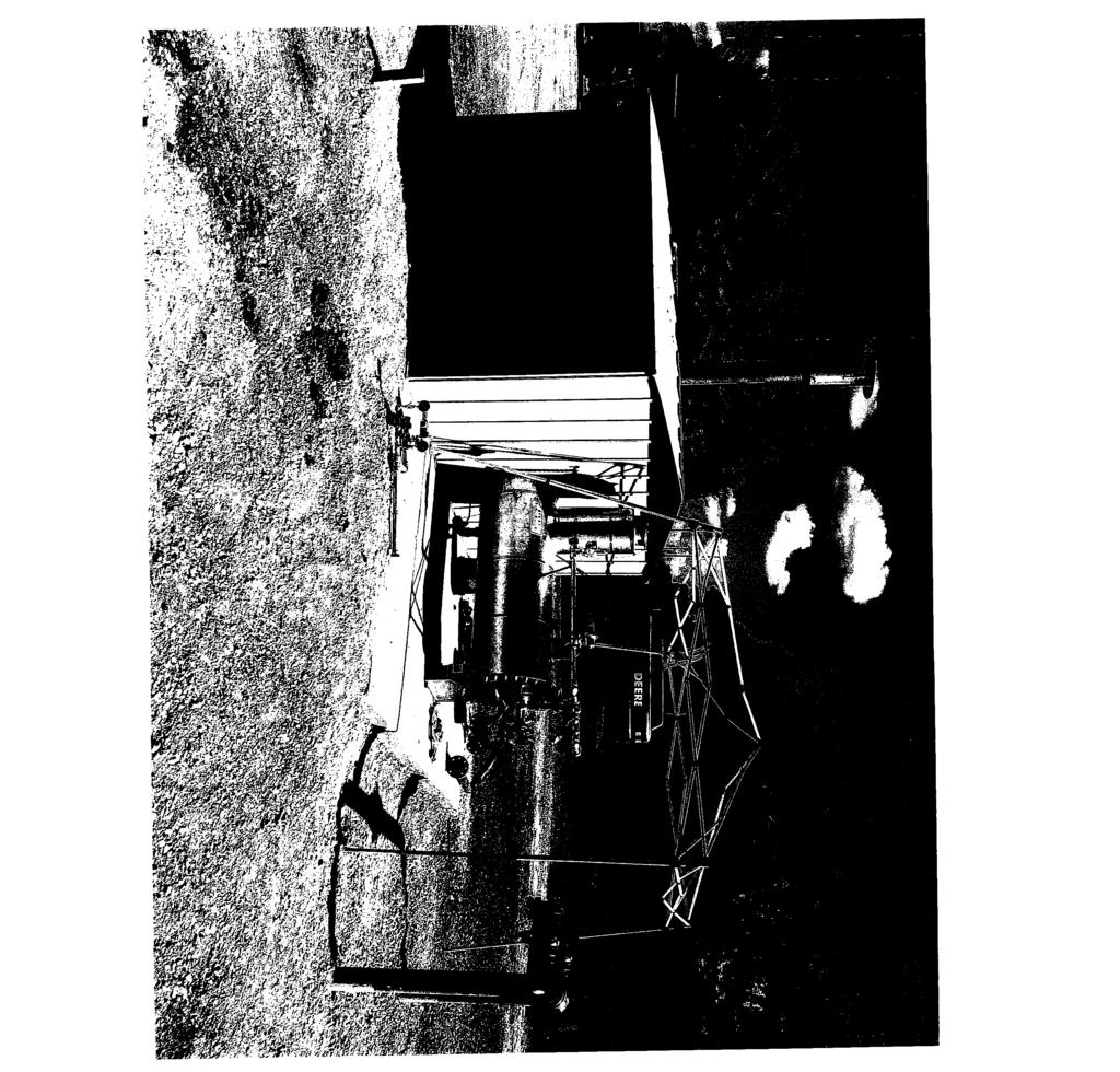
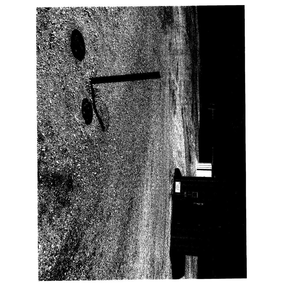
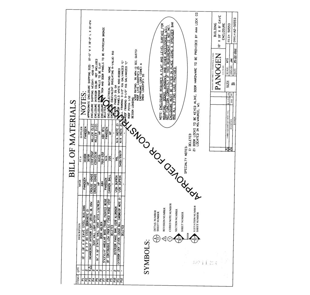
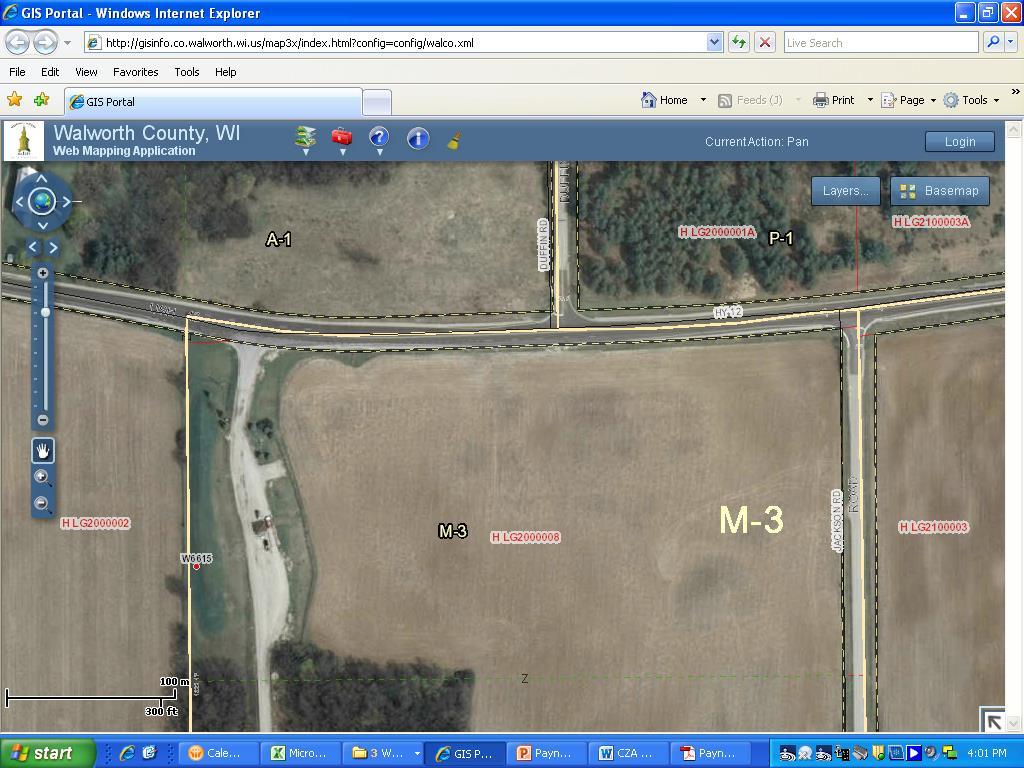
1 This report was prepared prior to the public hearing. This report may be supplemented or amended to reflect the review of additional information presented at the public hearing and written material submitted up to the meeting at which the decision is made by the Walworth County Zoning Agency. PRELIMINARY STAFF PLANNING REPORT TO THE WALWORTH COUNTY ZONING AGENCY TYPE OF PETITION: REZONE X CONDITIONAL USE NAME: Payne & Dolan Inc. Owner, Wis. Electric Power Co. (WE Energies) - Applicant LOCATION: The property of concern is located in the NE ¼ of Section 20, LaGrange Township and is identified as part of Tax Parcel H LG TOWN RESPONSE: Approved_X Denied: No Action: Tabled ZONING: The property of concern is zoned M-3 Mineral Extraction District. PROJECT DESCRIPTION: The application indicates: WE Energies is planning to build a new natural gas regulator station near the main entrance to the Payne & Dolan gravel pit (Old Nelson/Miller pit) off of Hwy 12. Initially the regulator station would serve the immediate needs of Payne & Dolan, Inc. and later will ensure continuation of reliable gas service to the surrounding communities. The regulator station would consist of a 10 X18 metal sided building to house the regulation equipment and a 5 X12 gas-fired preheater. Construction of the facility is scheduled for May and would be complete by October of No permanent employees will be located at the station once constructed. Employees would perform monthly maintenance and inspection typically driving a light van or pick-up truck. A conditional use approval is required under the heading of a utility. CONFORMANCE WITH COUNTY LAND USE PLAN: The Walworth County 2035 Land Use Plan identifies this area as the Extractive land use category. COMPATIBILITY WITH SURROUNDING LAND USES: To the north are lands zoned A-1 and P-1. To the east are properties zoned A-1 and C-2. To the south and west are lands zoned A-1. SITE CHARACTERISTICS: The following soil types are found on this site: FsB Class II Fox Silt Loam, 2 to 6% Slope IMPACT ON ROADS AND TRAFFIC:
2 The site is served by a private gravel pit drive off of Hwy 12 to the north of the parcel. OTHER RELEVANT DATA RECOMMENDATIONS: APPLICATION STATUS: X COMPLETE INCOMPLETE General: 1. Approved as per plan submitted for a gas regulator station as a utility with required conditions added. 2. Any proposed buildings shall be of an earth tone or neutral color (I.E. beige or tan). 3. Construction plans for the site shall be submitted to the County Zoning Office for review and permit approvals prior to the project beginning. 4. Construction related activities are only allowed on site between sunrise to sunset. 5. The easement must be used for the purpose for which it was granted. 6. The applicant must obtain a Land Disturbance Erosion Control and Stormwater Management permit from the County Land Conservation Office prior to any construction activities occurring on site. 7. All spoils spreading activities must be conducted in the approved identified locations. 8. All access to the site must be made as identified on the approved plan. 9. All contractor storage yards shall be located as identified on the approved plan and used as specified. 10. The applicant shall meet all applicable Federal, State and local regulations. 11. The applicant shall make all necessary arrangements for use and crossing of public roadways with the State, County and Town Highway Departments. 12. If the Land Management Department determines that changes in either the character of the use or the intensity of the use are not consistent with this approval, then those changes must be brought before the County Zoning Agency for approval. 13. Failure to actively exercise this conditional use within three years of the approval date shall result in automatic dismissal without prejudice. The property owner may request a time extension for actively exercising the conditional use. A time extension for actively exercising the conditional use must be requested in writing during the original three year period. Any extension requested during the three year active exercise period greater than one year beyond the original three year period shall require additional Town and County committee approvals. 14. The applicant is responsible for removal of the regulator station if it is no longer in use. If the regulator station is not operated for a continuous period of 12 months, it shall be considered abandoned. Abandoned utilities may be required to be removed within 90 days.

3
4
5

6
7
8
9
10
11
12
13
14
15
16
17
18
19
20
21
22
23

24 Gas Regulator Station Payne & Dolan/We Energies CU for Gas Regulator Station as a Utility Section 20, LaGrange Township Zoning Map

25 Gas Regulator Station Payne & Dolan/We Energies CU for Gas Regulator Station as a Utility Section 20, LaGrange Township Land Use Plan

26 Payne & Dolan/We Energies CU for Gas Regulator Station as a Utility Section 20, LaGrange Township Soils & Topo Map
27
PRELIMINARY STAFF PLANNING REPORT TO THE WALWORTH COUNTY ZONING AGENCY
 This report was prepared prior to the public hearing. This report may be supplemented or amended to reflect the review of additional information presented at the public hearing and written material submitted
PRELIMINARY STAFF PLANNING REPORT TO THE WALWORTH COUNTY ZONING AGENCY X CONDITIONAL USE
 This report was prepared prior to the public hearing. This report may be supplemented or amended to reflect the review of additional information presented at the public hearing and written material submitted
PRELIMINARY STAFF PLANNING REPORT TO THE WALWORTH COUNTY ZONING AGENCY X CONDITIONAL USE
 This report was prepared prior to the public hearing. This report may be supplemented or amended to reflect the review of additional information presented at the public hearing and written material submitted
PRELIMINARY STAFF PLANNING REPORT TO THE WALWORTH COUNTY ZONING AGENCY X CONDITIONAL USE
 This report was prepared prior to the public hearing. This report may be supplemented or amended to reflect the review of additional information presented at the public hearing and written material submitted
PRELIMINARY STAFF PLANNING REPORT TO THE WALWORTH COUNTY ZONING AGENCY X CONDITIONAL USE
 This report was prepared prior to the public hearing. This report may be supplemented or amended to reflect the review of additional information presented at the public hearing and written material submitted
PRELIMINARY STAFF PLANNING REPORT TO THE WALWORTH COUNTY ZONING AGENCY CONDITIONAL USE
 This report was prepared prior to the public hearing. This report may be supplemented or amended to reflect the review of additional information presented at the public hearing and written material submitted
PRELIMINARY STAFF PLANNING REPORT TO THE WALWORTH COUNTY ZONING AGENCY
 This report was prepared prior to the public hearing. This report may be supplemented or amended to reflect the review of additional information presented at the public hearing and written material submitted
PRELIMINARY STAFF PLANNING REPORT TO THE WALWORTH COUNTY ZONING AGENCY X CONDITIONAL USE
 This report was prepared prior to the public hearing. This report may be supplemented or amended to reflect the review of additional information presented at the public hearing and written material submitted
PRELIMINARY STAFF PLANNING REPORT TO THE WALWORTH COUNTY ZONING AGENCY X CONDITIONAL USE
 This report was prepared prior to the public hearing. This report may be supplemented or amended to reflect the review of additional information presented at the public hearing and written material submitted
Zioto Enterprises, LLC. Tax Parcel(s) B D and part of Tax Parcel B D Has been APPROVED subject to the following conditions:
 B D and part of Tax Parcel B D Has been APPROVED subject to the following conditions:") Amended 2/20/14 to allow portable scale and one year extension (see cond. #s 12 & 27) NAME: Zioto Enterprises, LLC TOWN: Darien The application indicates: The property owner is requesting conditional use
Amended 2/20/14 to allow portable scale and one year extension (see cond. #s 12 & 27) NAME: Zioto Enterprises, LLC TOWN: Darien The application indicates: The property owner is requesting conditional use
HOUSE BILL lr3434 A BILL ENTITLED. Department of the Environment Licensing and Permitting Prohibited for Mountaintop Removal Coal Mining
 M HOUSE BILL lr By: Delegate Hucker Introduced and read first time: March, 00 Assigned to: Rules and Executive Nominations A BILL ENTITLED 0 0 AN ACT concerning Department of the Environment Licensing
Spirit Lake North, LLC
 BONNER COUNTY PLANNING DEPARTMENT PLANNING AND ZONING COMMISSION STAFF REPORT FOR March 1, 2018 Project Name: Amendment & Zone Change: Spirit Lake North, LLC File Number,Type: AM 162-18/ZC365-18 Request:
Planning Justification Report
 Planning Justification Report, Township of Puslinch FARHI HOLDINGS CORPORATION Updated January 27, 2017 Zelinka Priamo Ltd. Page i TABLE OF CONTENTS Page No. 1.0 1.1 1.2 1.3 2.0 2.1 2.2 2.3 2.4 2.5 3.0
TOWNSHIP OF DOYLESTOWN APPLICATION FOR REVIEW OF SUBDIVISION OR LAND DEVELOPMENT PROPOSAL. Please PRINT; all information MUST be filled out completely
 TOWNSHIP OF DOYLESTOWN APPLICATION FOR REVIEW OF SUBDIVISION OR LAND DEVELOPMENT PROPOSAL Please PRINT; all information MUST be filled out completely Date: Name of Subdivision or Land Development: Location:
PERMIT FEES Within the shore impact zone (Includes Rip-Rap and Sand Blankets) $ Over 51 cubic yards $100.00
 $ Over 51 cubic yards $100.00") WHAT IS A LAND ALTERATION PERMIT? A land alteration permit is a permit to move or excavate dirt, gravel, sand, etc, on property, which is not incidental to an approved building permit or a septic system
WHAT IS A LAND ALTERATION PERMIT? A land alteration permit is a permit to move or excavate dirt, gravel, sand, etc, on property, which is not incidental to an approved building permit or a septic system
Certified Survey Map (CSM) Submittal Updated: 6/29/18
 Submittal Updated: 6/29/18") Certified Survey Map (CSM) Submittal Updated: 6/29/18 Town of Middleton 7555 W. Old Sauk Road Verona, WI 53593-9700 Phone: 608-833-5887 Fax: 608-833-8996 info@town.middleton.wi.us The Town of Middleton
Certified Survey Map (CSM) Submittal Updated: 6/29/18 Town of Middleton 7555 W. Old Sauk Road Verona, WI 53593-9700 Phone: 608-833-5887 Fax: 608-833-8996 info@town.middleton.wi.us The Town of Middleton
NOTICE OF STATE MANDATED FEE! Approx. = $900 per Acre to Rezone A-1 Land
 NOTICE OF STATE MANDATED FEE! Approx. = $900 per Acre to Rezone A-1 Land STATE OF WISCONSIN MANDATED FARMLAND PRESERVATION ZONE DISTRICT REZONE CONVERSION FEE Beginning January 1, 2010, the State of Wisconsin
MUDDY CREEK TOWNSHIP PO BOX 239 PORTERSVILLE, PA SUBDIVISION AND LAND DEVELOPMENT APPLICATION
 MUDDY CREEK TOWNSHIP PO BOX 239 PORTERSVILLE, PA 16051 724-368-3438 SUBDIVISION AND LAND DEVELOPMENT APPLICATION NOTE TO ALL APPLICANTS: This checklist must be completed in its entirety If an item is not
Incorporated Village of Port Jefferson 88 North Country Road, Port Jefferson, NY Telephone: (631) Fax: (631)
 Fax: (631)") 88 North Country Road, Port Jefferson, NY 11777 Telephone: (631) 473-4744 Fax: (631) 473-2049 TREE CLEARING & GRADING APPLICATION To avoid delay in the processing of your application, be sure all the information
88 North Country Road, Port Jefferson, NY 11777 Telephone: (631) 473-4744 Fax: (631) 473-2049 TREE CLEARING & GRADING APPLICATION To avoid delay in the processing of your application, be sure all the information
ARTICLE XXIII ADMINISTRATION
 ARTICLE XXIII ADMINISTRATION 20 2301. Duties of the Zoning/Code Enforcement Officer The Zoning/Code Enforcement Officer shall be appointed by the Board of Supervisors and may hold no elective office in
Zoning/Building Permit Application
 Zoning/Building Permit Application Location Address: Zoning District: Parcel #: -0626 Subdivision Name: Lot Size: CONTACT INFORMATION: Applicant s Name Address _ Email Owner s Name Address _ Email Professional
Local Government and Industrial Sand Mining. Wisconsin has no known petroleum deposits, but the state has lots of sand and the right kind of sand.
 Local Government and Industrial Sand Mining Wisconsin has no known petroleum deposits, but the state has lots of sand and the right kind of sand. Sandstone formations DNR data: http://dnr.wi.gov/topic/mines/ismmap.html
SECTION 10 STANDARD PLATS
 SECTION 10 - STANDARD PLATS Subdivision 1: Purpose Standard Plats allow the subdivision of land into lots smaller than the minimum metes and bounds size in the zoning district, and control road development
REPRESENTATIVE: Julie & Brad Nicodemus Black Squirrel Road Colorado Springs, CO 80809
 COMMISSIONERS: DARRYL GLENN (PRESIDENT) MARK WALLER (PRESIDENT PRO TEMPORE) STAN VANDERWERF LONGINOS GONZALEZ PEGGY LITTLETON PLANNING AND COMMUNITY DEVELOPMENT DEPARTMENT CRAIG DOSSEY, EXECUTIVE DIRECTOR
APPLICATION FOR SPECIAL USE PERMIT PLEASE SUBMIT 7 COMPLETE PACKETS
 GOODING COUNTY PLANNING AND ZONING COMMISSION 145 7 TH Avenue East PO Box 417 Gooding, Idaho 83330 Phone: (208) 934-5958 Fax: (208) 934-4363 www.goodingcounty.org/p&z.htm OFFICE USE ONLY: APPLICATION COMPLETE:
A. ARTICLE 16 - STEEP SLOPE CONSERVATION DISTRICT
 1600. 1601.A. ARTICLE 16 - STEEP SLOPE CONSERVATION DISTRICT SECTION 1600 PURPOSE The purpose of this Article is to expand upon the Community Development Objectives associated with environmental protection
Extractive Industrial Regulatory Ordinance No. 21 revised Dec. 28, 2010 EXTRACTIVE INDUSTRIAL REGULATORY ORDINANCE TYRONE TOWNSHIP, MICHIGAN
 40.101 Sec. 1. TITLE. EXTRACTIVE INDUSTRIAL REGULATORY ORDINANCE TYRONE TOWNSHIP, MICHIGAN ord. no. 21 eff. May 12, 1979, revised Dec. 28, 2010 This ordinance shall be known and cited as the Tyrone Township
To: Stillwater Town Board Reference: Horst Variance Request Stillwater Township, Minnesota Copies To: Town Board Kathy Schmoekel, Town Clerk
 MEMORANDUM To: Stillwater Town Board Reference: Horst Variance Request Copies To: Town Board Kathy Schmoekel, Town Clerk From: Soren Mattick, Attorney Daniel and Karla Horst, Applicants Ann Pung-Terwedo,
DEVELOPMENT GUIDE A. JURISDICTION. Staff contacts: Director of Planning, Building, and Technology John Hanson (803)
") A. JURISDICTION DEVELOPMENT GUIDE Director of Planning, Building, and Technology John Hanson (803) 951-4655 jhanson@lexsc.com The Town of Lexington reviews only projects that are located within its jurisdiction
A. JURISDICTION DEVELOPMENT GUIDE Director of Planning, Building, and Technology John Hanson (803) 951-4655 jhanson@lexsc.com The Town of Lexington reviews only projects that are located within its jurisdiction
Planning Commission Preliminary Plan LRC Subdivision Montville Township
 Planning Commission Preliminary Plan LRC Subdivision Montville Township Meeting: February 1, 2017 App. No.: 002-2017-PP Owner: Faith & Hope Land Dev. Co. Applicant: Montville Investors LLC Engineer: Weber
BONNER COUNTY PLANNING DEPARTMENT PLANNING & ZONING COMMISION STAFF REPORT APRIL 19, 2018
 BONNER COUNTY PLANNING DEPARTMENT PLANNING & ZONING COMMISION STAFF REPORT APRIL 19, 2018 Project Name: File Number,Type: Request: Legal Description: Location: Parcel Size: Parcel # Applicant: Project
Instructions to the Applicant
 CONDITIONAL USE PERMIT APPLICATION Lake of the Woods County Land and Water Planning Office 206 8 th Avenue Southeast, Suite #290 Baudette MN 56623-2867 www.co.lake-of-the-woods.mn.us Phone: (218) 634-1945
Chapter 136. SOIL EROSION
 1 of 8 12/19/2011 4:17 PM Township of Andover, NJ Monday, December 19, 2011 Chapter 136. SOIL EROSION [HISTORY: Adopted by the Township Committee of the Township of Andover by Ord. No. 77-11 (Ch. XVII
Final Plat Trails at Redwood Falls, Ph. 1 Hinckley Township EXECUTIVE SUMMARY
 Final Plat Trails at Redwood Falls, Ph. 1 Hinckley Township Meeting: December 5, 2018 App. No.: 069-2017-PP Owner: Skyland Land Company LLC Engineer: TGC Engineering, T. Crane Parcel Nos.: 016-03A-38-012,
County staff present Land Use and Resource Management Department Director Michael P Cotter, Associate Planner Matt Weidensee.
 County Zoning Agency MINUTES December 21, 2006 Meeting 6:00 p.m. 100 West Walworth Street Elkhorn, Wisconsin Chairman Kuhnke called the meeting to order at 6:00 p.m. Roll call Committee members present
KASSON TOWNSHIP PRIVATE ACCESS ROAD ORDINANCE ORDINANCE NO (EFFECTIVE: MAY 12, 2007)
") KASSON TOWNSHIP PRIVATE ACCESS ROAD ORDINANCE ORDINANCE NO. 2007-01 (EFFECTIVE: MAY 12, 2007) An ordinance providing for the standards and specifications incident to the development of Private Motor Vehicle
KASSON TOWNSHIP PRIVATE ACCESS ROAD ORDINANCE ORDINANCE NO. 2007-01 (EFFECTIVE: MAY 12, 2007) An ordinance providing for the standards and specifications incident to the development of Private Motor Vehicle
CONDITIONAL USE PERMIT APPLICATION FOR AN EXCAVATION/BORROW PIT INSTRUCTIONS
 City of Chesapeake Department of Planning Post Office Box 15225 Chesapeake, Virginia 23328-5225 (757) 382-6176 FAX (757) 382-6406 CONDITIONAL USE PERMIT APPLICATION FOR AN EXCAVATION/BORROW PIT INSTRUCTIONS
A motion and second to Approve the agenda as amended was made by Jeff Schramm and Supervisor Kupsik. The motion carried 5 0.
 County Zoning Agency MINUTES February 15, 2007 Meeting 6:00 p.m. 100 West Walworth Street Elkhorn, Wisconsin Chairman Kuhnke called the meeting to order at 6:00 p.m. Roll call Committee members present
A. Consideration of the unapproved December 8, 2015 minutes B. Consideration of the unapproved January 12, 2016 minutes
 OFFICIAL AGENDA PLANNING & ZONING COMMISSION CITY OF STARKVILLE, MISSISSIPPI MEETING OF TUESDAY, April 12, 2016 CITY HALL - COURT ROOM, 110 West Main Street, 5:30 PM I. CALL TO ORDER II. III. IV. PLEDGE
Glade Springs Village POA Frequently Asked Questions
 Glade Springs Village POA Frequently Asked Questions 1. What does the monthly assessment fee cover? The monthly assessment pays for golf, general operations, road maintenance and security. 2. Do residents
TOWNSHIP OF SOLON COUNTY OF KENT, MICHIGAN. Members: Robert Ellick, Fred Gunnell, Mark Hoskins, Mary Lou Poulsen
 As recommended by Planning Commission at its December 27, 2017 meeting TOWNSHIP OF SOLON COUNTY OF KENT, MICHIGAN At a regular meeting of the Township Board of the Township of Solon, Kent County, Michigan,
A.3. ARTICLE 7 PLAN REQUIREMENTS FOR MINOR SUBDIVISION AND/OR LAND DEVELOPMENT
 700. 701.A.3. ARTICLE 7 PLAN REQUIREMENTS FOR MINOR SUBDIVISION AND/OR LAND DEVELOPMENT SECTION 700 PURPOSE The purpose of this Article is to set forth a streamlined set of Plan Requirements for minor
ARTICLE III District Regulations. A map entitled "Franklin Zoning Map" is hereby adopted as part of this chapter 1.
 ARTICLE III District Regulations ~ 305-8. Adoption of Zoning Map. A map entitled "Franklin Zoning Map" is hereby adopted as part of this chapter 1. ~ 305-9. Official Zoning Map; amendments. Regardless
Planning Commission Hearing Date: 2/21/2017 Board of County Commissioners Hearing Date: 3/8/2017
 COMMISSIONERS: DARRYL GLENN (PRESIDENT) MARK WALLER (PRESIDENT PRO TEMPORE) STAN VANDERWERF LONGINOS GONZALEZ PEGGY LITTLETON PLANNING AND COMMUNITY DEVELOPMENT DEPARTMENT CRAIG DOSSEY, EXECUTIVE DIRECTOR
Location in Code Subject Fees
 Chapter 63, Building Construction, Article II, Single Family Residential Farming or Agricultural Commercial, Industrial, Multi Family Building Permits Residential decks, patio enclosures, porch roofs,
MAJOR SUBDIVISION PRELIMINARY PLAT CHECKLIST
 TOWNSHIP OF EGG HARBOR PLANNING BOARD/ZONING BOARD OF ADJUSTMENT 3515 BARGAINTOWN ROAD EGG HARBOR TOWNSHIP, NJ 08234 MAJOR SUBDIVISION PRELIMINARY PLAT CHECKLIST The following checklist is designed to
Annexation Procedure
 Annexation Procedure Meet with Planning Department Staff - Recommended Figure 1.9 Submit petition for Annexation, w/ majority of property owner s signature, legal description of proposed property, lot
The Ranches Sketch Plan
 The Ranches Sketch Plan APPLICATION: RURAL LAND USE PROCESS (AKA CLUSTER DEVELOPMENT) HEARING DATES: Planning Commission: 12 July 2017 at 6:30 pm Board of County Commissioners: TBD APPLICANT: REQUEST:
TOWNSHIP OF MENDHAM Ord. No
 ORDINANCE SUPPLEMENTING THE LAND USE ORDINANCE OF THE TOWNSHIP OF MENDHAM BY A NEW CHAPTER XXIVA ESTABLISHING THE REQUIREMENT OF AN ENVIRONMENTAL PERMIT AND AMENDING AND SUPPLEMENTING SAID ORDINANCE WITH
EXPLANATION OF PROCEDURE TO BE FOLLOWED PRESENTATION OF APPLICATION FOR ZONING BY-LAW AMENDMENT
 PORT COLBORNE CITY OF PORT COLBORNE SPECIAL COUNCIL MEETING AGENDA WEDNESDAY, AUGUST 21, 2013-6:30 P.M. Council Chambers, 3rd Floor, 66 Charlotte Street CALL MEETING TO ORDER Mayor Vance Badawey 1. CONFIRMATION
DRAFT Development Application Manual
 Arapahoe County Public Works and Development DRAFT Development Application Manual Common Requirements and Procedures for All Development Applications Submittal Requirements by Type of Development Application
Legal Description Part of the Western Half of the Eastern Half of the Northwest Quarter of Section 30, Le Ray Township
 Owner and Applicant s 20448 State Highway 83 Mankato, MN 56001 Request and Location Request for review and approval of a Conditional Use Permit to allow an Elder Care Residential Unit to be constructed
ARTICLE 14 PLANNED UNIT DEVELOPMENT (PUD) DISTRICT
 DISTRICT") ARTICLE 14 PLANNED UNIT DEVELOPMENT (PUD) DISTRICT Section 14.01 Intent. It is the intent of this Article to allow the use of the planned unit development (PUD) process, as authorized by the Michigan Zoning
ARTICLE 14 PLANNED UNIT DEVELOPMENT (PUD) DISTRICT Section 14.01 Intent. It is the intent of this Article to allow the use of the planned unit development (PUD) process, as authorized by the Michigan Zoning
STAFF REPORT. Arthur and Kathleen Quiggle 4(b)
") STAFF REPORT Application: Requests related to the construction of a 28' x 41' dwelling and 6' wrap-around open deck to replace an existing 24' x 32' cabin and wrap-around open deck and the installation
STAFF REPORT Application: Requests related to the construction of a 28' x 41' dwelling and 6' wrap-around open deck to replace an existing 24' x 32' cabin and wrap-around open deck and the installation
MINUTE ORDER BONNER COUNTY COMMISSIONERS PUBLIC HEARING MINUTES AUGUST 6, 2015
 MINUTE ORDER BONNER COUNTY COMMISSIONERS PUBLIC HEARING MINUTES AUGUST 6, 2015 CALL TO ORDER: Chair Cary Kelly called the Bonner County Commissioners hearing to order at 1:00 p.m. in the 3rd floor meeting
offered for sale UPPER RAFT CREEK RESERVE A recreational investment opportunity offered by
 offered for sale UPPER RAFT CREEK RESERVE A recreational investment opportunity 241.0 (+/-) total acres White County, Arkansas offered by Licensed in Arkansas, Louisiana, Mississippi, Tennessee and Texas
Lake of the Woods County Land Use Permit Instruction Sheet
 Lake of the Woods County Land Use Permit Instruction Sheet PROPERTY DATA SECTION Legal Description: Please write out your complete legal description. A written description on a separate sheet of paper
COUNTY OF LINCOLN, NORTH CAROLINA
 COUNTY OF LINCOLN, NORTH CAROLINA 302 NORTH ACADEMY STREET, SUITE A, LINCOLNTON, NORTH CAROLINA 28092 PLANNING AND INSPECTIONS DEPARTMENT 704-736-8440 OFFICE 704-732-9010 FAX To: George Wood, county manager
TOWNSHIP OF SOLON COUNTY OF KENT, MICHIGAN. The following preamble and ordinance were offered by Member Poulsen and seconded by ORDINANCE NO.
 Final TOWNSHIP OF SOLON COUNTY OF KENT, MICHIGAN At a regular meeting of the Township Board of the Township of Solon, Kent County, Michigan, held at the Township Hall, 15185 Algoma Avenue, N.E., Cedar
Subdivision - Application
 Planning and Development Services, 2001 Sherwood Drive, Sherwood Park, AB T8A 3W7 Phone 780-464-8080 Fax 780-464-8109 Email: Landuse&policyplanning@strathcona.ca (Page 1 of 5) This form is to be completed
***** Subchapter A. GENERAL PROVISIONS ***** PERMIT APPLICATIONS
 105.11. Permit requirements. 105.12. Waiver of permit requirements. Title 25 Environmental Protection Part I. Department of Environmental Protection Subpart C. Protection of Natural Resources Article I.
ARTICLE FIVE FINAL DRAFT
 ARTICLE FIVE 021218 FINAL DRAFT Sec. 503.6 Open Space Preservation Option Open Space Preservation Option Open Space Preservation developments may be approved in the AR, R-1, R-2 and R-3 zoning districts,
LAND OWNER OF SITE ADDRESS PHONE NUMBER FAX NUMBER. APPLICANT (if other than owner) ADDRESS PHONE NUMBER FAX NUMBER
 ADDRESS PHONE NUMBER FAX NUMBER") TELECOMMUNICATION TOWER CONDITIONAL USE PERMIT APPLICATION FOR WALWORTH COUNTY - $1025 The undersigned hereby applies to the Walworth County Zoning Agency (Walworth County Land Use and Resource Management
TELECOMMUNICATION TOWER CONDITIONAL USE PERMIT APPLICATION FOR WALWORTH COUNTY - $1025 The undersigned hereby applies to the Walworth County Zoning Agency (Walworth County Land Use and Resource Management
River Rock Estates Sketch Plan, a proposed major subdivision in S24, T35N R2W NMPM on County Rd 119 (PLN18-336)
") MEMORANDUM Archuleta County Development Services Planning Department 1122 HWY 84 P. O. Box 1507 Pagosa Springs, Colorado 81147 970-264-1390 Fax 970-264-3338 TO: Archuleta County Planning Commission FROM:
MEMORANDUM Archuleta County Development Services Planning Department 1122 HWY 84 P. O. Box 1507 Pagosa Springs, Colorado 81147 970-264-1390 Fax 970-264-3338 TO: Archuleta County Planning Commission FROM:
All roads developed to access four (4) or more parcels shall be constructed to Park County Road and Bridge Standards.
 or more parcels shall be constructed to Park County Road and Bridge Standards.") P a r k C o u n t y P l a n n i n g a n d Z o n i n g 1002 Sheridan Avenue Cody, WY 82414 Phone: 307-527-8540 35-40 ACRE SUBDIVISIONS www.parkcounty.us/planandzone.htm May 2011 This is only intended as
P a r k C o u n t y P l a n n i n g a n d Z o n i n g 1002 Sheridan Avenue Cody, WY 82414 Phone: 307-527-8540 35-40 ACRE SUBDIVISIONS www.parkcounty.us/planandzone.htm May 2011 This is only intended as
Boyertown Borough and Colebrookdale and Pike Townships Joint Zoning Ordinance
 Boyertown Borough and Colebrookdale and Pike Townships Joint Zoning Ordinance Berks County, Pennsylvania Effective Date - November 7, 2010 This Ordinance was prepared under the direction of the Boyertown
Burleigh County Water Resource District 1811 East Thayer Avenue Bismarck, North Dakota (701)
") Burleigh County Water Resource District 1811 East Thayer Avenue Bismarck, North Dakota 58501 (701) 222-3499 www.bcwrd.org Fox Island Flood Control Project Public Hearing Summary September 7, 2016 General
Burleigh County Water Resource District 1811 East Thayer Avenue Bismarck, North Dakota 58501 (701) 222-3499 www.bcwrd.org Fox Island Flood Control Project Public Hearing Summary September 7, 2016 General
MCPC MONONGALIA COUNTY PLANNING COMMISSION 243 High Street, Rm 110, Morgantown, WV Phone Fax
 GENERAL APPLICATION FOR DEVELOPMENT OF SIGNIFICANT IMPACT This application shall be used for all Level III reviews of developments of significant impact (DSI) that have a broader impact. Such impacts would
SUBDIVISION Application Information
 Application Information COMPLETE THE ATTACHED APPLICATION FORM by printing clearly or filling out all of the required fields electronically. The application must be signed by the registered owner(s) of
Letter of Intent May 2017 (Revised November 2017)
") THE BEACH AT WOODMOOR LETTER OF INTENT MAY 2017 (REVISED NOVEMBER 2017) OWNER/APPLICANT: CONSULTANT: Lake Woodmoor Holdings LLC N.E.S. Inc. 1755 Telstar Drive, Suite 211 619 North Cascade Avenue Colorado
THE BEACH AT WOODMOOR LETTER OF INTENT MAY 2017 (REVISED NOVEMBER 2017) OWNER/APPLICANT: CONSULTANT: Lake Woodmoor Holdings LLC N.E.S. Inc. 1755 Telstar Drive, Suite 211 619 North Cascade Avenue Colorado
BEFORE THE HEARING EXAMINER FOR THURSTON COUNTY
 COUNTY COMMISSIONERS Cathy Wolfe District One Diane Oberquell District Two Robert N. Macleod District Three HEARING EXAMINER BEFORE THE HEARING EXAMINER FOR THURSTON COUNTY In the Matter of the Application
Staff Report: Date: Applicant: Property Identification: Acreage of Request: Current Zoning of Requested Area: Requested Action: Attached:
 Staff Report: Completed by Jeff Palmer Director of Planning & Zoning Date: November 7, 2018 Applicant: Greg Smith, Oberer Land Developer agent for Ronald Montgomery ET AL Property Identification: Frontage
LAGRANGE TOWNSHIP BOARD OF ZONING APPEALS REQUEST FOR HOME OCCUPATION/CONDITIONAL PERMIT NEW
 LAGRANGE TOWNSHIP BOARD OF ZONING APPEALS REQUEST FOR HOME OCCUPATION/CONDITIONAL PERMIT NEW I AM REQUESTING A CONDITIONAL ZONING PERMIT FOR A HOME OCCUPATION. PRESENT ZONING DISTRICT: DATE: DESCRIPTION
In order to permit maximum applicability of the PUD District, PUD-1 and PUD-2 Districts are hereby created.
 ARTICLE III. PUD ned Unit Development Overlay District 205-128. Purpose. The PUD ned Unit Development Overlay District is intended to provide flexibility in the design of planned projects; to encourage
PRELIMINARY SUBDIVISION PLAN APPLICATION INSTRUCTIONS
 City of Chesapeake Department of Planning Post Office Box 15225 Chesapeake, Virginia 23328-5225 (757) 382-6176 FAX (757) 382-6406 PRELIMINARY SUBDIVISION PLAN APPLICATION INSTRUCTIONS PURPOSE A preliminary
Staff Report: Date: Applicant: Property Identification: Acreage of Request: Current Zoning of Requested Area: Requested Action: Attached:
 Staff Report: Completed by Jeff Palmer Director of Planning & Zoning Date: November 7, 2018, Updated November 20, 2018 Applicant: Greg Smith, Oberer Land Developer agent for Ronald Montgomery ET AL Property
8Land Use. The Land Use Plan consists of the following elements:
 8Land Use 1. Introduction The Land Use Plan consists of the following elements: 1. Introduction 2. Existing Conditions 3. Opportunities for Redevelopment 4. Land Use Projections 5. Future Land Use Policies
SPECIAL ZONING DISTRICTS
 SPECIAL ZONING DISTRICTS 5.01 5.99 RESERVED 5.100 PLANNED DEVELOPMENTS: Purpose: This district is intended to accommodate unified design of residential, commercial, office, professional services, retail
CHAPTER 14: DRIVEWAYS, TOWN HIGHWAYS, AND PRIVATE ROADS
 CHAPTER 14: DRIVEWAYS, TOWN HIGHWAYS, AND PRIVATE ROADS TABLE OF CONTENTS CHAPTER 14: PRIVATE DRIVEWAYS, TOWN HIGHWAYS AND PRIVATE ROADS 14-1 14.0100 AUTHORITY... 14-1 14.0200 TITLE... 14-1 14.0300 REGULATION
Date Received: Application Complete? YES / NO
 OFFICE USE ONLY Section 22 (Official Plan Amendment) Section 34 (Zoning Amendment), Section 36 (Holding Zone Removal), Section 41 (Site Plan Approval) and Section 45 (Minor Variance) of the Planning Act
LEGISLATIVE COUNSEL'S DIGEST
 Senate Bill No. 209 CHAPTER 8 An act to amend Sections 607, 2207, and 2714 of, and to add Sections 2006.5, 2770.1, and 2773.1.5 to, the Public Resources Code, relating to surface mining. [ Approved by
TOWN OF PLEASANT SPRINGS DANE COUNTY, WISCONSIN RECORD OF THE JOINT PLAN COMMISSION & TOWN BOARD MEETING OF SEPTEMBER 5, 2018
 TOWN OF PLEASANT SPRINGS DANE COUNTY, WISCONSIN RECORD OF THE JOINT PLAN COMMISSION & TOWN BOARD MEETING OF SEPTEMBER 5, 2018 MEETING LOCATION: Town Hall, 2354 County Road N, Stoughton WI 53589 PLAN COMMISSION
ARCHITECTURAL MODIFICATION GUIDELINES
 ARCHITECTURAL MODIFICATION GUIDELINES The following Architectural Modification Guidelines have been adopted by the Board of Directors of the Madison Green Homeowner s Association to be consistent and expand
Burnett County, WI SUBDIVISION VARIANCE APPLICATION, EXPLANATION, & REQUIREMENTS PROCESS (NOTE: PLEASE READ ENTIRE APPLICATION BEFORE PROCEEDING)
") Burnett County, WI SUBDIVISION VARIANCE APPLICATION, EXPLANATION, & REQUIREMENTS A variance is a relaxation of a standard in a land use ordinance. Subdivision variances are decided by the Land Use and
Burnett County, WI SUBDIVISION VARIANCE APPLICATION, EXPLANATION, & REQUIREMENTS A variance is a relaxation of a standard in a land use ordinance. Subdivision variances are decided by the Land Use and
Harding Real Estate Vacant Acres Highway 11 Elkhorn, WI Randy Erwin, Broker Associate
 Harding Real Estate 96.6 Vacant Acres Highway 11 Elkhorn, WI 53121 Randy Erwin, Broker Associate Harding Real Estate 1710 South Eastwood Dr. Woodstock, IL. 60098 Randy@RandyErwin.com www.randyerwin.com
these areas are compatible with such conditions. [Section (6) (c) C. R. S.]
![these areas are compatible with such conditions. [Section (6) (c) C. R. S.]](/thumbs/83/88180230.jpg "these areas are compatible with such conditions. [Section (6) (c) C. R. S.]") SECTION 14-200 PRELIMINARY PLAT 14-201 INTENT A Preliminary Plat is one of the first documents utilized when owners of a property wish to subdivide their property in accordance with State Statutes and
SECTION 14-200 PRELIMINARY PLAT 14-201 INTENT A Preliminary Plat is one of the first documents utilized when owners of a property wish to subdivide their property in accordance with State Statutes and
CHAPTER 5. PLANNED UNIT DEVELOPMENT REGULATIONS
 Section 5.1. Purpose CHAPTER 5. PLANNED UNIT DEVELOPMENT REGULATIONS 5.1. PURPOSE The purpose for Planned Unit Developments (PUDs) is established in Section 4.5 Zoning District Purpose Statements. 5.2.
Township of Collier 2418 Hilltop Road Presto, PA 15142
 Township of Collier 2418 Hilltop Road Presto, PA 15142 Fees: Major: 2 checks $600 + $50 per lot & $1700 Escrow) APPLICATION FOR SUBDIVISION major FINAL only Plans must be folded Rolled plans will not be
LAND USE PERMIT APPLICATION INSTRUCTION SHEET
 LAND USE PERMIT APPLICATION INSTRUCTION SHEET The Land Use Permit application must be carefully completed according to the following instructions. Please complete in ink or type. The appropriate fee must
USE BY SPECIAL REVIEW STAFF REPORT- UPDATE
 ~~DOUGLAS COl-U~!X www.douglas.co.us Department of Community Development Planning Services USE BY SPECIAL REVIEW STAFF REPORT- UPDATE December 2, 2014 TO: FROM: RE: Douglas County Planning Commission Pam
Zoning and Subdivision Regulations. Rebecca Roberts Center for Land Use Education UW Stevens Point/Extension
 Zoning and Subdivision Regulations Rebecca Roberts Center for Land Use Education UW Stevens Point/Extension Land Use Tools Comprehensive Plan describes the future vision of the community and how to achieve
PLANNING COMMISSION REPORT Regular Agenda Non-Public Hearing Item PRELIMINARY PLAT FOR JOHNSTON ADDITION; 706 E 23 RD ST (MKM)
") PP-16-00261 Item No. 2A- 1 PC Staff Report PP-16-00261 ITEM NO. 2A: PLANNING COMMISSION REPORT Regular Agenda Non-Public Hearing Item PRELIMINARY PLAT FOR JOHNSTON ADDITION; 706 E 23 RD ST (MKM) PP-16-00261:
PP-16-00261 Item No. 2A- 1 PC Staff Report PP-16-00261 ITEM NO. 2A: PLANNING COMMISSION REPORT Regular Agenda Non-Public Hearing Item PRELIMINARY PLAT FOR JOHNSTON ADDITION; 706 E 23 RD ST (MKM) PP-16-00261:
RECOMMENDATION REPORT
 SARPY COUNTY PLANNING & BUILDING DEPARTMENT RECOMMENDATION REPORT CHANGE OF ZONE (CZ 18-003) PRELIMINARY PLAT (PP 18-005) FINAL PLAT (FP 18-004) NIELSEN ADDITION APPLICANT: RODNEY AND MAUREEN NIELSEN PLANNING
A. CONSIDERATION OF THE UNAPPROVED MINUTES OF DECEMBER 11, 2018
 I. CALL TO ORDER OFFICIAL AGENDA PLANNING & ZONING COMMISSION CITY OF STARKVILLE, MISSISSIPPI MEETING OF TUESDAY, JANUARY 8, 2018 1ST FLOOR CITY HALL COURT ROOM 110 WEST MAIN STREET AT 5:30 PM II. III.
Planning & Zoning Department GENERAL APPLICATION 400 DeWitt Street - Portage, WI Phone: Fax:
 Planning & Zoning Department GENERAL APPLICATION 400 DeWitt Street - Portage, WI 53901 Phone: 608-742-9660 Fax: 608-742-9817 www.@co.columbia.wi.us The applicant hereby authorizes access to the property
MINUTES JOINT MEETING LINCOLN COUNTY and SIOUX FALLS PLANNING COMMISSIONS 7:00 pm July 14, 2010
 MINUTES JOINT MEETING LINCOLN COUNTY and SIOUX FALLS PLANNING COMMISSIONS 7:00 pm July 14, 2010 Commissioners Room - Lincoln County Court House A joint meeting of Lincoln County and Sioux Falls Planning
ARTICLE 7. SPECIFIC USE STANDARDS
 ARTICLE 7. SPECIFIC USE STANDARDS Section 7.1 Applicability The following standards apply to specified uses in all zoning districts in which such uses are allowed. Section 7.2 Accessory Apartments (A)
Columbia Development Tracker
 Columbia Development Tracker October 1, 2018 The Columbia Development Tracker incorporates projects or development proposals going through their entitlement and/or planning review process. The tracker
Investment Opportunity Rupley Site
 Investment Opportunity Rupley Site Site size 5.28 acres Location Northwest corner of exit 48 off of South Huntington Access I-5 freeway, street access directly from South Huntington (on truck route), BNSF
STATE OF ALABAMA SHELBY COUNTY
 STATE OF ALABAMA SHELBY COUNTY Members Present: Members Absent: Staff Present: SHELBY COUNTY PLANNING COMMISSION MINUTES Regular Meeting March 6, 2017 6:00 PM Michael O Kelley, Chairman; Jim Davis, Vice