LAND USE PERMIT APPLICATION INSTRUCTION SHEET
|
|
|
- Emma Todd
- 5 years ago
- Views:
Transcription
1 LAND USE PERMIT APPLICATION INSTRUCTION SHEET The Land Use Permit application must be carefully completed according to the following instructions. Please complete in ink or type. The appropriate fee must accompany the application. Refer to the top of the application for applicable fees. Make the check payable to Lake County Auditor. Applications must be signed by applicant and contractor (if applicable) to be considered complete. Incomplete applications will be returned. Property owners must allow time for processing prior to starting construction. Permit applications may be delivered in person, or mailed. The Lake County Land Use Office will make every attempt to process this application within five (5) business days of receipt. Once processed, permits will be mailed within three working days. The Permit placard must be conspicuously posted. CONTRACTOR LIABILITY/LANDOWNER STATEMENT Permit applications submitted for grading, filling, or soil excavation shall require the signature of the contractor/agent, as well as the property owner. A. GENERAL PROPERTY INFORMATION Property Owner information: name, mailing address, and phone number of property owner. Property Address: List only if the physical address of the property is not the mailing address. If no address has been assigned, give directions to site. The Land Use Office will provide the Sheriff with a copy of the application, who will assign a 911 locatable address. Authorized Agent or Contractor: If applicable, list the authorized agent or the contractor. Check box if the permit should go to the agent or contractor. B. PROPERTY DESCRIPTION Legal description of the property must be complete, including as applicable: Section, Township, Range, Township name and Acreage as it is given on the title or tax statement. Include the complete legal description. If lengthy, the legal description can be attached on a separate sheet. Parcel Code #: Eleven digit number (ie, ) that can be found on your tax statement. This is required for a complete application. Lake or river name: If the property is within 1000 feet of a lake or within 300 feet or a river. Access Road: List the main (County, State, Township) road that provides access to your property. Lot Dimensions: Lot width and depth in feet, taken at the property line. Existing use: Describe structures or other physical improvements currently on the property and the nature of their use. Property Land Features: Please circle all that apply to your property. North Shore Management Zone: (NSMZ) An area boundary defined along the forty (40) acre subdivision lines of the rectangular coordinate system established in the U.S. Public Land Survey, nearest to the landward side of a line one thousand (1000) feet from the shoreline of Lake Superior or three hundred (300) feet landward from the centerline of U.S. Highway 61, whichever is greater, with the exception that from the western limits of Lake County to the western limits of the City of Two Harbors the boundary is the centerline of the southbound lane of the U.S. Highway 61 Expressway. Lake Superior Erosion Hazard Areas and if bank stabilization has occurred. Maps are available for viewing. Shoreland/Shoreland zone The North Shore Management Zone and any property within 1000 feet of a lake or 300 feet of a river. Lake /River frontage - bordering/or including a stream, river or lake on property, even though that might not be where you are intending to build. Indicate how many feet of shoreland frontage is on your property. Wetland if present on the property, indicate amount of impact in section D and show wetlands on your sketch. Bluff if present on the property, indicate on sketch and setback achieved. A bluff is defined as a topographic feature such as a hill, cliff, or embankment having all of the following characteristics: part or all of the feature is located in a shoreland area; the slope rises at least twenty-five (25) feet above the ordinary high water level of the waterbody; the grade of the slope from the toe of the bluff to a point twenty-five (25) feet or more above the ordinary high water level averages thirty percent (30%) or greater; and the slope must drain toward the waterbody. An area with an average slope of less than eighteen percent (18%) over a distance of fifty (50) feet or more shall not be considered part of the bluff.
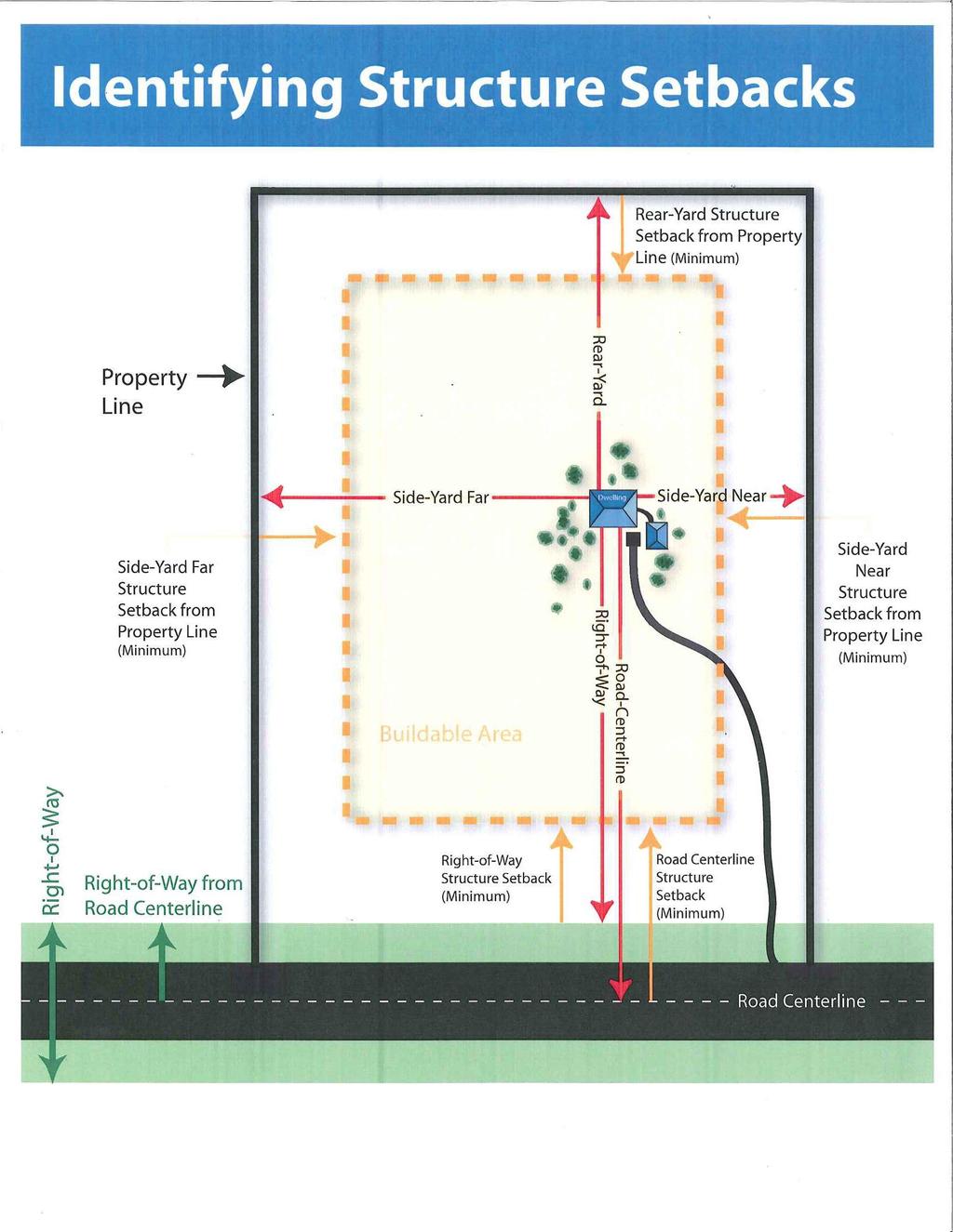
2 C. SEWAGE DISPOSAL/SEPTIC INFORMATION&WELL Sanitary Districts: Check if in a planning area or sanitary district. In Knife River, you must first contact the appropriate parties in your district to acquire a permit prior to returning this application for processing. Your application will not be considered complete without written district approval. Sewer planning area: Specify the planning area. If in the Castle Danger Sewer District, you must contact the Silver Creek Town Board. They have assumed controls for this area and all permits will be issued though their Board, not Lake County. Septic Systems: Check appropriate box indicating the status of the current septic system, indicate permit number, year installed, size (bedrooms) of system, and the name of property owner at the time of septic installation. For new home construction on vacant property, a Septic System Application must be issued prior to or in conjunction with a Land Use Application. For construction on developed property, there must be a complying septic system with a Certificate of Compliance on file with Lake County. If there is no Certificate of Compliance on file, monies will need to be put into an escrow account for sewer upgrade. A Septic System Application must be submitted in conjunction with the Land Use Application. D. PROJECT DATA Project proposal on this application: Check appropriate box. New construction, addition, or relocation of any structure, if applicable. Sign Indicate size and precise location of sign(s) proposed. Grade/Fill: Indicate the amount/area of fill to be placed and distance to vegetation line. If this is being done by a qualified contractor (we have a list), they can help you. Caution, in most cases added permitting is required. Wetland disturbance may require special handling from the Land Use Office. If you intend to fill areas, contact this office well in advance. National Wetland Inventory Maps are on file at this and the S. W. C. D. Offices. Vegetation Removal - Indicate whether vegetation removal will occur and provide information on sketch. (Shoreland areas require special considerations and disturbances within 50 feet of shoreland are severely restricted.) Road/Driveway - Indicate length in feet of driveway to be placed. An access permit is generally required. Contact the appropriate road authority (Highway Department , or MN DOT ) or township. Type of Structure: Indicate type of structure(s) to be placed, the proposed use of the structure, and dimensions of each structure. E. SKETCH PLAN All structures on the property must be included on your sketch. Label all distances and dimensions as measured in feet, identifying neighboring owners, their wells, and sewer locations. Refer to the attached sample sketch and provide a North Directional Arrow. F. STRUCTURE SETBACKS (all setbacks are measured horizontally) Nearest side setback measurement is the closest distance from the side property line to your proposal. In the instance of an addition, the measurement that should be given is the closest point of the structure to the property line, whether it is new or existing. Farthest side setback measurement is the longer distance to the side property line from your proposed or existing structure. Rear yard setback is the distance from the proposal to the property lines opposite the road or opposite the lake if in shoreland. Shoreline setback is the horizontal distance measured at the closest point of the proposal to the vegetation line. Road setbacks The right-of-way distance is the measurement from the right-of-way to the proposal. The road centerline is the measurement from the center of the road to the proposal. REMEMBER TO SIGN THE APPLICATION, STAKE THE PROPOSED PROJECT, and ATTACH APPROPRIATE FEES. INCOMPLETE APPLICATIONS WILL BE RETURNED. If you have questions, please contact the Lake County Planning & Zoning Office at (218)
3 SUPPLEMENTAL DATA FOR LAND USE PERMITS A. PLANNING CHECKLIST (required for all permits): YES NO N/A 1. Are you aware of your zoning district setback requirements? Note: Setback distances are taken from any projection of the building (i.e. overhangs, eaves, decks, etc.) 2. Will zoning district impervious surface requirements be met? Note: Maximum impervious surface coverage varies depending on the zoning district. 3. If your property has Lake Superior shoreline, have you verified whether it is within an Erosion Hazard Area? 4. Has the location of the well, sewage treatment area, future buildings, driveways, and decks been considered? 5. Are commercial structures being considered on the site? 6. If your property is in shoreland, does any topographic feature meet the definition of a bluff? (If YES, complete Section C on the back of this form) SHORELAND: Any property within 1,000 feet of a lake or 300 feet of a river, stream or flowage. BLUFF: Defined as a slope (hill, cliff, or embankment) rising 25 ft. or greater above the ordinary high water level of the waterbody and the grade of the slope from the toe of the bluff to a point 25 ft or more above the high water level averages 30% or greater. 7. Are there any lowlands or wetlands on or near the project site? (If YES, complete Section C on the back of this form) 8. Will wetland grading or filling occur with this project? (If YES, complete Section C on the back of this form) 9. Is grading and filling or vegetation removal proposed in the Shore Impact Zone (within 50 of the shoreline)? (If YES, complete Section C on the back of this form) If N/A is checked on any of the above questions, expect delays in the processing of this application. B. SITE INFORMATION (required for all permits): **All proposed structures must be corner staked** ** Proposed driveways must be flagged at the driveway centerline** Failure to stake the proposed structure or flag the proposed driveway may delay the processing of this application. Random site visits are completed to check placement of proposed structures and driveways. Property Owner: Daytime Contact Number: Property Address: PROPERTY OWNER SIGNATURE: DATE: If you have any questions, please contact the Planning and Zoning office at (218) Ordinances are available online at WE LOOK FORWARD TO WORKING WITH YOU
4 === C. NATURAL LANDSCAPE PROTECTION PLAN: (Complete this section if you were directed to in Section A OR if you are working within 1,000 feet of a lake or 300 feet of any river, stream or flowage.) 1. Description of proposed construction: 2. Describe the existing vegetative cover type(s). (i.e. forested, grass, shrub, lawn, etc.)? 3. Setback of proposed construction from the vegetation line (ie. lakes, streams, rivers, creeks, etc.)? 4. Height of lowest floor (including basement) above the ordinary high water level? 5. Describe activities that will occur within the Shore Impact Zone and/or the Shoreland Zone (ie. grading and filling, clearing of trees & shrubs, soil disturbance) 6. What percent slope of the land currently exists at the construction site? 7. If the construction site or driveway contains steep slopes, how will they be protected? (no land/soil disturbance permitted on slopes 18% or greater) 8. What methods will be used to control erosion during construction and following construction? Check all that apply. seed/mulch water bars other (please explain) rip-rap silt fence rock check dams erosion blankets I have read the above and I understand the Natural Landscape Protection Plan as prepared. I hereby agree to implement this plan as part of the Land Use Permit. PROPERTY OWNER SIGNATURE DATE
5 Environmental Services Planning & Zoning 601 Third Avenue Two Harbors, MN Fax: LAKE COUNTY LAND USE APPLICATION Please Complete In Ink INCLUDE FEE WITH APPLICATION Dwelling/Principal Structure: $100 Change of use/additional Structures: $50 each Grade/Fill: $50 After the fact fee: $400 Permit # Routing: Applicant Agent Contractor Sheriff Township Assessor Health Dept (Commercial) Electrical Insp: Richard Rue: Bruce Bonicatto: A. GENERAL PROPERTY INFORMATION Property Owners Name Day Phone Authorized Agent or Contractor Check box if permit is to go to agent or contractor. Complete Mailing Address Property Address (if other than mailing) Agent or Contractor Address (if applicable) B. PROPERTY DESCRIPTION Section Township Range Township Name Acreage Parcel ID # (REQUIRED) Quarter Section/Legal Description Lake/River Name Nearest Road Access Lot Dimensions Width ft. Depth ft. Existing Land Use (Example: residential, commercial, vacant, etc.) Circle Property Land Features: Yes No North Shore Management Zone Yes No Wetland Present (If yes, show on sketch) Yes No Lake Superior Erosion Hazard Area Yes No Bluff Present (If yes, show on sketch) Yes No Shoreland / Shoreland zone (within 1000' of lake or 300' of river) - Lake/River frontage feet C. SEPTIC / WELL INFORMATION. LAKE COUNTY ORDINANCE #11 REQUIRES COMPLIANCE INSPECTION IF SEPTIC SYSTEM IS OVER 12 YEARS OLD OR NOT HAD A PASSING COMPLIANCE INSPECTION WITHIN THE LAST 8 YEARS. BEDROOM ADDITIONS: SEPTIC SYSTEM MUST BE 5 YEARS OLD OR PASSED COMPLIANCE INSPECTION WITHIN LAST 3 YEARS. Is this property located within the Knife River Sanitary District? Yes* No *Lake County will not issue a Land Use Permit within the Knife River Sanitary District without prior written approval from the Sanitary District. Contact Knife River Sanitary District at OR is property located within a sewer planning area? Yes No If yes, please specify district: IF NO PLUMBING IN ANY STRUCTURE ON PROPERTY AN EXEMPTION CERTIFICATE MUST BE SIGNED, NOTARIZED, AND ATTACHED TO APPLICATION. Septic On Property?: Yes No Outhouse/Privy If Yes, Septic Permit SP - - Property Owner Name At Time Of Installation: Year Septic Installed: Date Of Compliance Inspection: Well On Property? Yes No Lake Water System? Yes No D. PROJECT PROPOSAL (Check all that apply for this project) New Construction Outhouse/Privy: (Bottom of pit must be 3 above water table, 100 List # of Bedrooms: Sign from any water supply, & meet all applicable setbacks.) Addition Wetland Disturbance* * Contractor Responsibility Bedroom Addition Grade/Fill* Acknowledgement Form Required (New Total # of Bedrooms: ) Vegetation Removal* Building Relocation Road/Driveway*: length x width x depth (traveled surface) Garage/Shed (New driveways require a driveway access permit. Refer to application checklist) (If garage, will there be living quarters inside? yes no # of bedrooms: ) Grade/Fill Information: Shoreland/Shoreland Zone (within 1000 of lake or 300 of river): Circle: Upland or wetland Non-shoreland Circle: Upland or wetland Estimated wetland fill (cu yds): Estimated non-wetland fill (cu yds): TYPE OF STRUCTURE Proposed use of structure (Example: single family home, garage, workshop, guest quarters, commercial, etc.) Dimensions (including eaves): ft x ft. # of stories Height ft. TYPE OF STRUCTURE Proposed use of structure (Example: single family home, garage, workshop, guest quarters, commercial, etc.) Dimensions (including eaves): ft x ft. # of stories Height ft. TYPE OF STRUCTURE Proposed use of structure (Example: single family home, garage, workshop, guest quarters, commercial, etc.) Dimensions (including eaves): ft x ft. # of stories Height ft.
6 The purpose of the sketch is to graphically illustrate the information included in your application. Please include the dimensions of all structures (present and proposed), wells, septic systems, and distances to property lines, roadways, lakes, rivers and streams. The following items must be included and listed in the boxes below: Location of Location of Distance to Name of wetlands areas of vegetation removal and grading road centerline abutting property owners bluff property lines (size and shape of parcel) shoreline or rear yard adjacent roads driveway well/septic system & expansion side property lines legal access road (labeled) (yours and neighbors) well, septic & drain fields show any applicable easements needed to access your property all structures on the property **This application will be returned without adequate sketch plan and/or incomplete setback distances.** ***All proposed structures and/or driveways must be corner staked at the construction site.*** COMPLETE SECTION F (PROPOSED STRUCTURE SETBACKS) ON THE FOLLOWING PAGE
7 F. STRUCTURE SETBACKS APPLICATION CONSIDERED INCOMPLETE WITHOUT THESE SETBACKS DISTANCE OF PROPOSED STRUCTURE FROM PROPERTY LINES (AS SHOWN ON SKETCH) NEAREST SIDE YARD SETBACK ft. FARTHEST SIDE YARD SETBACK ft. REAR YARD SETBACK ft. **COMPLETE IF YOUR PROPERTY IS IN A SHORELAND AREA (within 1,000 of a lake OR 300 of a river, OR within the North Shore Management Zone) ** OR if there is an unclassified watercourse with a defined bottom on your property. STRUCTURE DISTANCE FROM VEGETATION LINE*: ft. FOR LAKE SUPERIOR SHORELINE, STRUCTURE DISTANCE IS ft. FROM THE VEGETATION LINE & ft. FROM THE WATERS EDGE. STRUCTURE DISTANCE FROM TOP OF BLUFF**: ft. check here if not applicable *VEGETATION LINE: The line defining where vegetation on land begins. The vegetation line is not where a single bush, tree, flower, etc. grows from the rocks or the side of a cliff. A sod layer is needed to be considered the vegetation line. If the vegetation line is not clear, we can assist in this determination. **BLUFF: A slope (hill, cliff, or embankment) rising 25 ft. or greater above the ordinary high water level of the waterbody and the grade of the slope from the toe of the bluff to a point 25 ft or more above the high water level averages 30% or greater. APPLICATION WILL BE RETURNED IF DRIVEWAY INFORMATION IS INCOMPLETE COMPLETE IF YOUR DRIVEWAY IS OFF A PUBLIC ROAD: 1) WIDTH OF RIGHT OF WAY FROM CENTERLINE: = ft. (RIGHT-OF-WAY Information for County, State, or Township Roads may be obtained by contacting your proper road authority (Lake County Hwy at , MN DOT at , or the applicable township clerk.) AND 2) STRUCTURE MEASUREMENT FROM THE RIGHT-OF-WAY DISTANCE YOU HAVE STATED ABOVE IS: = ft. COMPLETE IF YOUR DRIVEWAY IS OFF A PRIVATE ROAD: 1) STRUCTURE DISTANCE FROM THE CENTER OF THE ROAD: ft. I hereby certify that I am the owner of the described property and that all uses will conform with existing state laws and local ordinances. I further certify that I will comply with all conditions placed upon this permit should this application be approved. Intentional or unintentional falsification of this application or any attachments thereto will serve to make this application and any resultant permit invalid. I agree to provide erosion control measures including, but not limited to, mulch and silt fencing in accordance with Best Management Practices. I also certify that the separation distances on this sketch plan are to the best of my knowledge true and correct. I consent to site visits by County representatives and understand that a land use permit must be issued prior to any activities taking place on the property. Owner (print) Signature of Owner Date The property owner s signature is required below if an Authorized Agent is to act on their behalf, giving permission to the agent to modify and make changes to this application. The Authorized Agent s signature is also required. Owner (print) Signature of Owner Date Authorized Agent (print) Signature of Authorized Agent Date I understand under contractor liability laws (M.S.103G.2212), that I share responsibility for compliance with appropriate laws & ordinances. Contractor (print) Signature of Contractor Date FOR ELECTRICAL QUESTIONS PLEASE CONTACT: State of Minnesota FOR ELECTRICAL INSPECTIONS: Electrical Licensing & Inspection Unit Phone: (651) Richard Rue: Lafayette Road N OR Bruce Bonicatto: St. Paul, MN Z- Fee: Receipt #: By: Date Issued: Zone District: Lake/River Classification: If Lk Superior, Erosion Hazard Area? Yes No verified by DATE OFSSTS </= 12 YRS Remarks: OR DATE PASSED COMPLIANCE CHECK </= 8 YRS Application Revision Date: 6/28/2018
8


9 ENVIRONMENTAL SERVICES Planning & Zoning Courthouse, rd Avenue Two Harbors, MN PH: ~ FX: CONTRACTOR RESPONSIBILITY ACKNOWLEDGEMENT AND LANDOWNER STATEMENT Pursuant to Minnesota Chapter 103G.2212 an agent or employee of another may not drain, fill, or excavate a wetland, wholly or partially, unless the agent or employee has obtained a signed statement from the property owner stating that the wetland replacement plan required for the work has been obtained, or that a replacement plan is not required. Submit this form with a Land Use Permit Application for soil disturbing activities and access development. Minor road and driveway maintenance, structure placement, or the installation of a sewage treatment system does not require the completion of this form. Property Owner Name Property Address Property Legal Description Property Owner s Complete Mailing Address Contractor/Agent Name Contractor Address Phone Description of Work Proposed I certify that, as the owner of the property listed on this form, I have contacted Lake County and that a wetland replacement plan: (Check appropriate box) has been obtained, or; is not required. for the work described at the location listed on this form. Property Owner Name (print) Signature Date Contractor/Agent Name (print) Signature Date Return this form with the Land Use Application
10 VIOLATION OF MINNESOTA STATUTES 103G.2212 IS A MISDEMEANOR PUNISHABLE BY UP TO A $700 FINE AND 90 DAYS IN JAIL. Soil Disturbance Thresholds: A) Shore Impact Zones (within 50 feet of vegetation line), Bluff Impact Zones (within 20 feet of top of bluff) and Steep Slopes: 1) Under 10 cubic yards - no permit required. 2) Ten to 50 cubic yards - Land Use Permit required. 3) More than 50 cubic yards - Applications shall not be considered complete until plans approved by the Hydrology Technical Committee are submitted. B) Shoreland (within 300 feet of a protected water stream or 1000 feet of a lake or within the North Shore Management Zone): 1) Less than 50 cubic yards - No permit required. 2) Fifty (50) to 500 cubic yards of material - Land Use Permit required. 3) More than 500 cubic yards - Applications shall not be considered complete until plans approved by the Hydrology Technical Committee are submitted. 4) Wetlands disturbances in shoreland zones are limited to 400 square feet and then only with a permit. Activities above this threshold require special handling from the Land Use Office, (see also Article 8.0 of this Ordinance). 5) In the North Shore Management Zone an erosion and sediment control plan must be submitted under the following circumstances: a) For land disturbances exceeding one thousand (1,000) square feet or one hundred (100) cubic yards. b) For fill exceeding one thousand (1,000) cubic yards. c) For any shoreland alteration exceeding fifty (50) cubic yards within the structure setback area. Shoreland alterations done in connection with work authorized by a building or sewage disposal permit shall be exempt from the erosion control plan requirements. C) Non-Shoreland (The remainder of the County): 1) Less than 100 cubic yards - No permit required. 2) One hundred (100) to 1000 cubic yards-land Use Permit required. 3) More than 1000 cubic yards - Applications shall not be considered complete until plans approved by the Hydrology Technical Committee are submitted. 4) Wetland disturbances are limited to 10,000 square feet and then only with a permit. Activities above this threshold require special handling from the Land Use Office, (see also Article 8 of this Ordinance.
11 LAND USE PERMIT APPLICATION CHECKLIST HAVE YOU: Signed the application in all required areas. Attached the appropriate fees. Contacted the appropriate road authority (Lake County Highway, MN DOT, or applicable Township) for the right-of-way distance & for a Driveway Access Permit application, if constructing a new driveway. Obtained a permanent legal access to your property. Shown all existing and proposed structures and their setbacks on the sketch. Do these measurements correspond with those listed in Section F (Structure setbacks)? Completed Section C (Septic Information) and attached a copy of the septic Certificate of Compliance if available. Attached Sewer Exemption Certificate form (if applicable). If there are no structures with plumbing on the property, this form is required. Has the contractor signed the Contractor Responsibility Acknowledgement (if applicable)? Required for soil disturbing activities and driveway/access development.
LAKE COUNTY INTERIM USE APPLICATION VACATION RENTAL HOME
 Environmental Services Planning & Zoning Courthouse 601 Third Avenue Two Harbors, MN 55616 (218)834-8327 LAKE COUNTY INTERIM USE APPLICATION VACATION RENTAL HOME PLEASE COMPLETE IN INK INCLUDE FEES WITH
INCOMPLETE APPLICATIONS WILL BE RETURNED! GENERAL PROPERTY INFORMATION. Applicant s name Day Phone address Authorized Agent (if applicable)
") Environmental Services Planning & Zoning 601 Third Avenue Two Harbors, MN 55616 www.co.lake.mn.us (218)834-8327 Fax: (218)-834-8365 LAKE COUNTY ADMINISTRATIVE SUBDIVISION APPLICATION PLEASE COMPLETE IN
Environmental Services Planning & Zoning 601 Third Avenue Two Harbors, MN 55616 www.co.lake.mn.us (218)834-8327 Fax: (218)-834-8365 LAKE COUNTY ADMINISTRATIVE SUBDIVISION APPLICATION PLEASE COMPLETE IN
Lake of the Woods County Land Use Permit Instruction Sheet
 Lake of the Woods County Land Use Permit Instruction Sheet PROPERTY DATA SECTION Legal Description: Please write out your complete legal description. A written description on a separate sheet of paper
Instructions to the Applicant
 CONDITIONAL USE PERMIT APPLICATION Lake of the Woods County Land and Water Planning Office 206 8 th Avenue Southeast, Suite #290 Baudette MN 56623-2867 www.co.lake-of-the-woods.mn.us Phone: (218) 634-1945
Lake of the Woods County Land Use Permit Instruction Sheet
 Lake of the Woods County Land Use Permit Instruction Sheet PROPERTY DATA SECTION Legal Description: Please write out your complete legal description. A written description on a separate sheet of paper
PERMIT FEES Within the shore impact zone (Includes Rip-Rap and Sand Blankets) $ Over 51 cubic yards $100.00
 $ Over 51 cubic yards $100.00") WHAT IS A LAND ALTERATION PERMIT? A land alteration permit is a permit to move or excavate dirt, gravel, sand, etc, on property, which is not incidental to an approved building permit or a septic system
WHAT IS A LAND ALTERATION PERMIT? A land alteration permit is a permit to move or excavate dirt, gravel, sand, etc, on property, which is not incidental to an approved building permit or a septic system
{{t:t;r:n;o:"signer 2";l:"Date";}}
 Application/File # Date Application Rec'd: Oct 13 2017 Fee Collected $ (for office use only) CONDITIONAL USE APPLICATION MOTLEY MN Site Address (E-911#): 164 MORRISON STREET WEST 410095000 Lake/River Name:
206 8 th Ave SE Suite #290 Baudette, MN Phone: Fax: Instructions to Applicant
 Lake of the Woods County Land & Water Planning Office Phone: 218-634-1945 Fax: 218-634-2509 www.co.lake-of-the-woods.mn.us Instructions to Applicant 1. All items on all pages must be completed in INK and
Attached is a Clinton Township Zoning Permit Application and requirements for issuance of a permit.
 To Whom It May Concern: Attached is a Clinton Township Zoning Permit Application and requirements for issuance of a permit. The fee for the permit application is $75.00, which shall be made payable to
ALEXANDRIA TOWNSHIP Land Use/Building Permit Application
 Application # Date Application Rec d / / Fee Collected $ (for office use only) ALEXANDRIA TOWNSHIP Land Use/Building Permit Application Site Address (E-911#): Parcel Number (9 digits): - - Legal Description
Directions For Filling Out A CAMA MINOR Permit
 Directions For Filling Out A CAMA MINOR Permit Please fill out the application completely including applicant's signature on the second page. Be sure to complete the "statement of ownership" and the "adjacent
ARTICLE 5 MINOR SUBDIVISION/LAND DEVELOPMENT
 ARTICLE 5 MINOR SUBDIVISION/LAND DEVELOPMENT SECTION 501 ONLY FINAL PLAN REQUIRED The classification of a proposed subdivision as a "Minor Subdivision" shall only require the submission, review and approval
Land Use Permit Application Hubbard County Environmental Services Application Fees After-the-fact permits FAQs When is a land use permit required?
 Application Fees (Fees on denied applications are non-refundable): a. Dwelling unit, including attached garage, and/or deck. $100.00 b. All other structures (non dwelling units)... $ 50.00 c. Legal addition
BOROUGH OF BANGOR ZONING PERMIT APPLICATION PACKET. Submission Checklist
 BOROUGH OF BANGOR 197 Pennsylvania Avenue, Bangor, PA 18013 Phone: 610-588-2216 Fax: 610-588-6468 http://bangorborough.org ZONING PERMIT APPLICATION PACKET Submission Checklist Application completed in
MAJOR SUBDIVISION PRELIMINARY PLAT CHECKLIST
 TOWNSHIP OF EGG HARBOR PLANNING BOARD/ZONING BOARD OF ADJUSTMENT 3515 BARGAINTOWN ROAD EGG HARBOR TOWNSHIP, NJ 08234 MAJOR SUBDIVISION PRELIMINARY PLAT CHECKLIST The following checklist is designed to
PLANNING CLEARANCE. Planning Clearance is required prior to the submittal of most building and development permit applications.
 PLANNING CLEARANCE Description Planning Clearance is the County s review of the site plan for a proposed development, and is the starting point for most of the County s permitting processes, including
Please complete each entry and check off each item. An incomplete application will be returned.
 CARLTON COUNTY ZONING AND ENVIRONMENTAL SERVICES Permit number 301 Walnut Avenue, Room 103 P.O. Box 220 Carlton, MN 55718-0220 Township 218-384-9176 www.co.carlton.mn.us CONDITIONAL OR INTERIM USE PERMIT
I. Requirements for All Applications. C D W
 108-16.1. Application checklists. Checklist for Required Submissions to the Planning Board or Zoning Board of Adjustment of Monroe Township All required submissions are to be made to the Administrative
APPLICATION PROCEDURE
 ANTRIM PLANNING BOARD P. O. Box 517 Antrim, New Hampshire 03440 Phone: 603-588-6785 FAX: 603-588-2969 APPLICATION FORM AND CHECKLIST FOR MINOR OR MAJOR SITE PLAN REVIEW File Date Received By APPLICATION
Septic Tank / Drainfield / Holding Tank Permit Application
 Septic Tank / Drainfield / Holding Tank Permit Application : Permit # : PID #: Septic Fee $: Soil Verification Fee $: Investigative/Other Fee $: PLEASE PRINT CLEARLY Total Permit Fee $: The Applicant Is:
E L M E R B O R O U G H L A N D U S E B O A R D APPLICATION COVER SHEET (to be completed for all applications and appeals)
") E L M E R B O R O U G H L A N D U S E B O A R D APPLICATION COVER SHEET (to be completed for all applications and appeals) 1. Name(s): 2. Address: 3. Telephone Number(s): 4. E-mail: 5. Owner Name(s) (if
E L M E R B O R O U G H L A N D U S E B O A R D APPLICATION COVER SHEET (to be completed for all applications and appeals) 1. Name(s): 2. Address: 3. Telephone Number(s): 4. E-mail: 5. Owner Name(s) (if
LOT LINE ADJUSTMENT GENERAL INFORMATION AND
 LOT LINE ADJUSTMENT GENERAL INFORMATION AND APPLICATION Mariposa County Planning Department 5100 Bullion Street, P.O. Box 2039 Mariposa, CA 95338 Telephone (209) 966-5151 FAX (209) 742-5024 www.mariposacounty.org
SECTION 4: PRELIMINARY PLAT
 SECTION 4: PRELIMINARY PLAT After the completion of the sketch plan process, if submitted, the owner or developer shall file with the City an application for preliminary plat. The preliminary plat stage
SITE ANALYSIS LEVEL II (SALII) INTAKE CHECKLIST
 INTAKE CHECKLIST") Skamania County Community Development Department Building/Fire Marshal Environmental Health Planning Skamania County Courthouse Annex Post Office Box 1009 Stevenson, Washington 98648 Phone: 509-427-3900
Skamania County Community Development Department Building/Fire Marshal Environmental Health Planning Skamania County Courthouse Annex Post Office Box 1009 Stevenson, Washington 98648 Phone: 509-427-3900
City of Prior Lake APPLICATION FOR COMBINED PRELIMINARY AND FINAL PLAT
 Case File No. Property Identification No. City of Prior Lake APPLICATION FOR COMBINED PRELIMINARY AND FINAL PLAT Requested Action Brief description of proposed project (Please describe the proposed amendment,
(If you do not have a 911 address, please complete an E-911 New Property Address Assignment Application )
") CARLTON COUNTY ZONING AND ENVIRONMENTAL SERVICES 301 Walnut Avenue, Room 103 P.O. Box 220 Carlton, MN 55718-0220 218-384-9176 www.co.carlton.mn.us ZONING PERMIT APPLICATION Permit number Township Please
CARLTON COUNTY ZONING AND ENVIRONMENTAL SERVICES 301 Walnut Avenue, Room 103 P.O. Box 220 Carlton, MN 55718-0220 218-384-9176 www.co.carlton.mn.us ZONING PERMIT APPLICATION Permit number Township Please
Construction & Earthwork Request Form (CERF)
") ShoreLand Traditions Construction & Earthwork Request Form (CERF) SECTION 1 SECTION 2 SECTION 3 Definitions and Points to Remember Requirements and Process Site Sketch Requirements and Sample If you have
ShoreLand Traditions Construction & Earthwork Request Form (CERF) SECTION 1 SECTION 2 SECTION 3 Definitions and Points to Remember Requirements and Process Site Sketch Requirements and Sample If you have
LABEL PLEASE NOTE: ALL APPLICATIONS AND SITE PLANS MUST BE COMPLETED IN BLACK OR BLUE INK ONLY Intake by:
 STAFF USE ONLY Thurston County Resource Stewardship 2000 Lakeridge Dr. S.W. Olympia, WA 98502 (360)786-5490 / (360)754-2939 (Fax) TDD Line (360) 754-2933 Email: permit@co.thurston.wa.us Supplemental Application
NOTICE TO ALL PERSONS SUBMITTING ACCESS APPLICATIONS OBTAINED FROM THE INTERNET.
 NOTICE TO ALL PERSONS SUBMITTING ACCESS APPLICATIONS OBTAINED FROM THE INTERNET. For access location and addressing purposes, you are required to post a green flag at the exact location of your proposed
City of Midland Application for Site Plan Review
 City of Midland Application for Site Plan Review Submission Date: Property Owner: Mailing Address: Phone number: ( ) Cell phone: ( ) Email address: Fax: ( ) Owner s Signature: Applicant Name (if not owner):
City of Prior Lake APPLICATION FOR REGISTERED LAND SURVEY
 Case File No. Property Identification No. City of Prior Lake APPLICATION FOR REGISTERED LAND SURVEY Requested Action Brief description of proposed project (Please describe the proposed amendment, project,
STAFF REPORT. Arthur and Kathleen Quiggle 4(b)
") STAFF REPORT Application: Requests related to the construction of a 28' x 41' dwelling and 6' wrap-around open deck to replace an existing 24' x 32' cabin and wrap-around open deck and the installation
STAFF REPORT Application: Requests related to the construction of a 28' x 41' dwelling and 6' wrap-around open deck to replace an existing 24' x 32' cabin and wrap-around open deck and the installation
Charter Township of Garfield Grand Traverse County
 Charter Township of Garfield Grand Traverse County 3848 VETERANS DRIVE TRAVERSE CITY, MICHIGAN 49684 PH: (231) 941-1620 FAX: (231) 941-1588 GUIDE FOR THE SUBMISSION OF AN APPLICATION FOR SITE PLAN REVIEW
BRIDGETON SUBDIVISION APPLICATION CHECKLIST
 APPLICATION NAME AND # CHECKLIST COMPLETED BY: DATE: Signature and printed name BRIDGETON SUBDIVISION APPLICATION CHECKLIST TO SUBDIVISION APPLICANTS: The attached checklist is to assist you in the submission
CHECKLIST INFORMATION NECESSARY FOR ZONING PERMITS
 Information for Zoning Permits (Updated: 2016.11.04 Itasca County Environmental Services 123 NE 4 th Street Grand Rapids, MN 55744 Phone: (218) 327-2857 Fax: (218) 327-7331 TDD: (218) 327-2806 Fax: (218)
PRELIMINARY PLAT Checklist
 PRELIMINARY PLAT Checklist 3715 Bridgeport Way W University Place, WA 98466 PH: (253) 566-5656 FAX: (253) 460-2541 This is a checklist of materials required for a Preliminary Plat. This checklist is provided
TOWNSHIP OF EGG HARBOR ZONING BOARD ADJUSTMENT CHECK LIST
 TOWNSHIP OF EGG HARBOR ZONING BOARD ADJUSTMENT CHECK LIST Schedule A - General Requirements 1. Where the application involves only a variance one (1) original and nineteen (19) copies of the appropriate
Septic Tank / Drainfield / Holding Tank Permit Application
 Septic Tank / Drainfield / Holding Tank Permit Application : Permit # : PID #: Septic Fee $: Soil Verification Fee $: Investigative/Other Fee $: PLEASE PRINT CLEARLY Total Permit Fee $: The Applicant Is:
Individual Well Individual Septic. Community Well 19. What is the proposed method of sewage disposal? Public. None
 Please Answer the Following Questions: (attach sheet if needed). What type of facility is being proposed? Campground Recreational Vehicle (RV) Park Both 2. What is the total acreage of the proposed facility?
Interim Use Permit Application
 BENTON COUNTY DEPARTMENT OF DEVELOPMENT 531 DEWEY STREET, PO BOX 129 FOLEY, MN 56329-0129 PHONE: (320) 968-5065 FAX: (320) 968-5351 Interim Use Permit Application Application Fee: $400 ($754 if it is an
INSTRUCTIONS FOR THE PREPARING AND FILING OF APPLICATIONS WITH THE SRCC. APPLICATION CHECKLIST AND DEADLINE FOR FILING Sewage Disposal Plan (HHE-200)*
*") SACO RIVER CORRIDOR COMMISSION P.O. BOX 283, 81 MAPLE STREET ~ CORNISH, MAINE 04020-0283 TELEPHONE (207) 625-8123 ~ FAX (207) 625-7050 ~ E-MAIL: srcc@srcc-maine.org VISIT US ON THE WEB AT www.srcc-maine.org
SACO RIVER CORRIDOR COMMISSION P.O. BOX 283, 81 MAPLE STREET ~ CORNISH, MAINE 04020-0283 TELEPHONE (207) 625-8123 ~ FAX (207) 625-7050 ~ E-MAIL: srcc@srcc-maine.org VISIT US ON THE WEB AT www.srcc-maine.org
SUBDIVISION APPLICATION CHECKLIST SKETCH PLAN PRELIMINARY PLAT FINAL PLAT
 RECEIVED STAMP SUBDIVISION APPLICATION CHECKLIST SKETCH PLAN PRELIMINARY PLAT FINAL PLAT A checklist of background information and submission requirements for processing of a sketch plan, preliminary plat
OSS SITE EVALUATION APPLICATION INTAKE CHECKLIST
 Skamania County Community Development Department Building/Fire Marshal Environmental Health Planning Skamania County Courthouse Annex Post Office Box 1009 Stevenson, Washington 98648 Phone: 509-427-3900
** If your lot does not meet the requirements above, please read Sec below
 Sec. 13-1-60 Zoning District Dimensional Requirements. For the Zoning Dept To Issue a Land Use Permit The Following Dimensions are Required. Minimum Side and Rear Yards s Lakes Classification Minimum Class
PLANNING & DEVELOPMENT SERVICES 1800 Continental Place Mount Vernon, WA Inspections Office Fax 360.
 PLANNING & DEVELOPMENT SERVICES 1800 Continental Place Mount Vernon, WA 98273 Inspections 360.416.1330 Office 360.416-1320 Fax 360.416-1340 Date Received: Administrative Setback Reduction Checklist Pursuant
Gates County Planning and Zoning
 Gates County Planning and Zoning PO Box 411, 200 Court Street, Gatesville, NC 27938 phone: 252-357-2411 fax: 252-357-0073 Application for Technical Review Committee For Staff Use Only: Date: Application
TOWNSHIP OF BORDENTOWN LAND DEVELOPMENT APPLICATION CHECKLIST. General Requirements for all Applications
 TOWNSHIP OF BORDENTOWN LAND DEVELOPMENT APPLICATION CHECKLIST This CHECKLIST has been adopted in accordance with Section 25:807 of the Land Development Ordinance of the Township of Bordentown and will
City of Prior Lake APPLICATION FOR PRELIMINARY PLAT
 City of Prior Lake APPLICATION FOR PRELIMINARY PLAT Requested Action Brief description of proposed project (Please describe the proposed amendment, project, or variance request. Attach additional sheets
TOWNSHIP OF GEORGIAN BLUFFS APPLICATION FOR AMENDMENT TO THE ZONING BY-LAW
 TOWNSHIP OF GEORGIAN BLUFFS APPLICATION FOR AMENDMENT TO THE ZONING BY-LAW NOTE A PRECONSULTATION MEETING IS REQUIRED PRIOR TO THE SUBMISSION OF APPLICATIONS FOR A ZONING BY-LAW AMENDMENT OR REZONING.
MINOR SUBDIVISION INFORMATION
 A. POINTS OF CONTACT: MINOR SUBDIVISION INFORMATION Surveyor: Address: Phone #: Fax # E-Mail Address: Representative (If different from applicant): Address: Phone #: Fax # E-Mail Address: B. GENERAL INFORMATION:
IMPORTANT NOTICE MINOR VARIANCE APPLICATION
 This document contains both information and form fields. To read information, use the Down Arrow from a form field. IMPORTANT NOTICE MINOR VARIANCE APPLICATION Please be advised that the Committee of Adjustment
CHAPTER 3 PRELIMINARY PLAT
 10-3-1 10-3-3 SECTION: CHAPTER 3 PRELIMINARY PLAT 10-3-1: Consultation 10-3-2: Filing 10-3-3: Requirements 10-3-4: Approval 10-3-5: Time Limitation 10-3-6: Grading Limitation 10-3-1: CONSULTATION: Each
City of Yelm. Community Development Department BOUNDARY LINE ADJUSTMENT OR LARGE LOT SUBDIVISION
 City of Yelm Community Development Department BOUNDARY LINE ADJUSTMENT OR LARGE LOT SUBDIVISION Fee Date Received By File No. FEES: Boundary Line Adjustment $100.00 LARGE LOT SUBDIVISION $250.00, + $10.00/lot
BONNER COUNTY PLANNING DEPARTMENT
 BONNER COUNTY PLANNING DEPARTMENT 1500 HIGHWAY 2, SUITE 208, SANDPOINT, ID 83864 (208) 265-1458 (208) 265-1463 (FAX) planning@bonnercountyid.gov (email) www.bonnercounty.us (web page) INFORMATION SHEET
Remember, PA One-Call before excavating. Simply dial 811 or
 LTL CONSULTANTS, LTD 610-987-9290 / Toll Free 888-987-8886 REQUIREMENTS FOR OBTAINING A BUILDING PERMIT $50.00 Application Fee payable to Colebrookdale Township due upon submission of this application
ZONING BOARD OF APPEALS APPLICATION
 ZONING BOARD OF APPEALS APPLICATION Town of Westbrook ZBA Appeal No. Land Use Department Mulvey Municipal Center, 866 Boston Post Road, Connecticut 06498 (860)-399-3047 Fax (860)-399-2084 ZBA App. Fee
TOWNSHIP OF DOYLESTOWN APPLICATION FOR REVIEW OF SUBDIVISION OR LAND DEVELOPMENT PROPOSAL. Please PRINT; all information MUST be filled out completely
 TOWNSHIP OF DOYLESTOWN APPLICATION FOR REVIEW OF SUBDIVISION OR LAND DEVELOPMENT PROPOSAL Please PRINT; all information MUST be filled out completely Date: Name of Subdivision or Land Development: Location:
MINOR SUBDIVISION PLAT CHECKLIST
 MINOR SUBDIVISION PLAT CHECKLIST Project Name: Tax ID #: Project Number: Date: _ Reviewed By: Telephone: NOTES: All lots on septic systems must comply with the Fulton County Health Department requirements
WRIGHT TOWNSHIP Ottawa County 1565 Jackson Street, P.O. Box 255, Marne, Michigan 49435
 WRIGHT TOWNSHIP Ottawa County 1565 Jackson Street, P.O. Box 255, Marne, Michigan 49435 SPECIAL USE PERMIT APPLICATION _ Instructions For an application to be considered complete, ALL information must be
Waseca County Planning and Zoning Office
 Waseca County Planning and Zoning Office 300 North State Street Waseca, Minnesota 56093 Phone: 507-835-0650 Fax: 507-837-5310 Form no. PZ 081009 Web Site: www.co.waseca.mn.us FEES: 1) CUP FEE- $400.00
LAND USE PERMIT APPLICATION
 LAND USE PERMIT APPLICATION Date Application No. TYPE OF PERMIT Subdivision Short Plat Conditional Use Binding Site Plan Final Plat Final Short Plat Variance Final Binding Site Plan Plat Amendment Short
CANNABIS APPLICATION CHECKLIST
 COUNTY OF MENDOCINO DEPARTMENT OF PLANNING AND BUILDING SERVICES 860 NORTH BUSH STREET UKIAH CALIFORNIA 95482 120 WEST FIR STREET FORT BRAGG CALIFORNIA 95437 IGNACIO GONZALEZ, INTERIM DIRECTOR PHONE: 707-234-6650
~ Please Detach and Save This Page ~
 COMMUNITY DEVELOMENT DEPARTMENT 110 E. Sycamore St., 4 th Floor Sycamore, IL 60178 (815) 895-7188 planningdept@dekalbcounty.org www.dekalbcounty.org Building Permit Instructions ~ Please Detach and Save
Castle Danger Subordinate Service District Phase I Land Use Ordinance #1
 Castle Danger Subordinate Service District Phase I Land Use Ordinance #1 Effective February 2, 2010 Castle Danger Subordinate Service District Phase I Land Use Ordinance SECTION I PURPOSE The purpose of
APPLICATION FOR SITE PLAN CONTROL
 APPLICATION FOR SITE PLAN CONTROL Information and material to be provided under Section 41 of the Planning Act Township of Lanark Highlands PO Box 340, 75 George Street Lanark, ON K0G 1K0 T: 613.259.2398
FINAL PLAT CHECKLIST
 FINAL PLAT CHECKLIST Project Name: Tax ID #: Project Number: Date: _ Reviewed By: Telephone: Please address all items marked with an "X" Please return redline comments with corrected plan, original mylar,
Septic Tank / Drainfield / Holding Tank Permit Application
 Becker Township Date: Permit # : PID #: Septic Tank / Drainfield / Holding Tank Permit Application Septic Fee $: Soil Verification Fee $: LUP Refund $: Other Fee ( ) $: Total Permit Fee $: The Applicant
TOWN OF LAKE LURE LAND DISTURBANCE PERMIT (LESS THAN 1 ACRE) Permit Fee Permit No. LDP- (see Fee Schedule below) Approved:
 Permit Fee Permit No. LDP- (see Fee Schedule below) Approved:") TOWN OF LAKE LURE LAND DISTURBANCE PERMIT (LESS THAN 1 ACRE) Permit Fee Permit No. LDP- (see Fee Schedule below) Approved: Expiration Date: Erosion Control Officer Rejected: (see attached explanation)
TOWN OF LAKE LURE LAND DISTURBANCE PERMIT (LESS THAN 1 ACRE) Permit Fee Permit No. LDP- (see Fee Schedule below) Approved: Expiration Date: Erosion Control Officer Rejected: (see attached explanation)
SUBMITTAL REQUIREMENTS: The number indicates the number of copies for submittal (if applicable).
.") Office Use Only Preliminary Long Plat Long Subdivision Applicant Checklist PLANNING, COMMUNITY, & ECONOMIC DEVELOPMENT DEPARTMENT FINAL LONG PLAT LONG SUBDIVISION CHECKLIST Mailing Address: P.O. Box 547,
Office Use Only Preliminary Long Plat Long Subdivision Applicant Checklist PLANNING, COMMUNITY, & ECONOMIC DEVELOPMENT DEPARTMENT FINAL LONG PLAT LONG SUBDIVISION CHECKLIST Mailing Address: P.O. Box 547,
Umatilla County Department of Land Use Planning
 Umatilla County Department of Land Use Planning 216 SE 4 th ST, Pendleton, OR 97801, (541) 278-6252 Property Line Adjustment, Type V Application & Information Packet PROCESSING THE APPLICATION The application
Guide to Combined Preliminary and Final Plats
 Guide to Combined Preliminary and Final Plats Introduction The Douglas County is committed to providing open, transparent application processes to the public. This Guide is provided to assist anyone interested
SHORT PLAT Information
 Information This form provides information and an explanation of the procedures of a Short Plat. If you have any questions, contact the Planning and Development Services Department at (253) 566-5656. A
PRE CONSTRUCTION CHECK LIST FOR BUILDING PERMITS
 PRE CONSTRUCTION CHECK LIST FOR BUILDING PERMITS PLAN AHEAD the following items must be completed, as outlined below, when submitting your building permit application. BE AWARE that if you do not live
Please complete each entry and check off each item. An incomplete application will be returned.
 CARLTON COUNTY ZONING AND ENVIRONMENTAL SERVICES 301 Walnut Avenue, Room 103 P.O. Box 220 Carlton, MN 55718-0220 218-384-9176 www.co.carlton.mn.us Permit number Township MINOR SUBDIVISION APPLICATION The
Make checks payable to Columbia County Treasurer. We do not issue refunds. Credit Cards accepted.
 Columbia County Camping Application Planning & Zoning Department Pursuant to Columbia County Ordinance 16-130-050(D)(5)(i) Phone: (608) 742-9660 Fax: (608) 742-9817 www.co.columbia.wi.us 112 E. Edgewater
OWNERSHIP DETAILS. Mailing Address: City / Town: Postal Code. Phone Business: ( ) Residence: ( ) FAX: ( )
 Residence: ( ) FAX: ( )") P.O. Box 81067 838 Mineral Springs Road Ancaster, ON L9G 4X1 Email: Darren.Kenny@conservationhamilton.ca x131 Jaime.Tellier@conservationhamilton.ca x165 Phone: (905) 648-4427 or (905) 525-2181 FAX: (905)
P.O. Box 81067 838 Mineral Springs Road Ancaster, ON L9G 4X1 Email: Darren.Kenny@conservationhamilton.ca x131 Jaime.Tellier@conservationhamilton.ca x165 Phone: (905) 648-4427 or (905) 525-2181 FAX: (905)
PLANNING BOARD CITY OF CONCORD, NH MINOR SUBDIVISION CHECKLIST
 PLANNING BOARD CITY OF CONCORD, NH MINOR SUBDIVISION CHECKLIST Summary This checklist is intended to assist applicants and design professionals in the preparation of minor subdivision applications for
SUBMITTAL REQUIREMENTS: The number indicates the number of copies for submittal (if applicable).
.") Office Use Only Preliminary Long Plat Long Subdivision Applicant Checklist PLANNING, COMMUNITY, & ECONOMIC DEVELOPMENT DEPARTMENT PRELIMINARY LONG PLAT LONG SUBDIVISION CHECKLIST Mailing Address: P.O.
Office Use Only Preliminary Long Plat Long Subdivision Applicant Checklist PLANNING, COMMUNITY, & ECONOMIC DEVELOPMENT DEPARTMENT PRELIMINARY LONG PLAT LONG SUBDIVISION CHECKLIST Mailing Address: P.O.
MINOR & MAJOR SUBDIVISION APPLICATION
 TOW OF HOOKSETT APPLICATIO # DATE MIOR & MAJOR SUBDIVISIO APPLICATIO Application for: Completeness Map and Lot o. Public Hearing o. of Lots LOCATIO: (Specify Street Address) OWER: APPLICAT: ADDRESS: ADDRESS:
TENTATIVE PARCEL MAP APPLICATION GUIDE TENTATIVE PARCEL MAP APPLICATION REQUIREMENTS
 TENTATIVE PARCEL MAP APPLICATION GUIDE SISKIYOU COUNTY PLANNING DIVISION 806 South Main Street, Yreka CA 96097 Phone: (530) 841-2100 / Fax: (530) 841-4076 TENTATIVE PARCEL MAP APPLICATION REQUIREMENTS
OWNERSHIP DETAILS. Mailing Address: City / Town: Postal Code. Phone Business: ( ) Residence: ( ) FAX: ( )
 Residence: ( ) FAX: ( )") P.O. Box 81067 838 Mineral Springs Road Ancaster, ON L9G 4X1 Email: Darren.Kenny@conservationhamilton.ca x131 Jaime.Tellier@conservationhamilton.ca x165 Phone: (905) 648-4427 or (905) 525-2181 FAX: (905)
P.O. Box 81067 838 Mineral Springs Road Ancaster, ON L9G 4X1 Email: Darren.Kenny@conservationhamilton.ca x131 Jaime.Tellier@conservationhamilton.ca x165 Phone: (905) 648-4427 or (905) 525-2181 FAX: (905)
Zoning Permit Application Cover Page
 Zoning Permit Application Cover Page The City of Belmont performs an initial site inspection prior to issuance of a zoning permit for new construction. Upon receipt of a full and complete application submittal
ARTICLE 6 PRELIMINARY PLAT
 ARTICLE 6 PRELIMINARY PLAT SECTION: 30-06-01: Preliminary Plat 30-06-02: Information Required for Preliminary Plat 30-06-03: Determination of Requirement for Environmental Review Documents 30-06-04: Additional
(Continued on back of page)
") Definitions Certificate of Survey is the subdivision of land into three or fewer tracts of land. The remnant tract counts as one tract. Plat is the subdivision of land into more than three tracts of land.
Definitions Certificate of Survey is the subdivision of land into three or fewer tracts of land. The remnant tract counts as one tract. Plat is the subdivision of land into more than three tracts of land.
Application for OFFICIAL PLAN AMENDMENT
 Town of Northeastern Manitoulin & the Islands Application for OFFICIAL PLAN AMENDMENT and/or ZONING BY-LAW AMENDMENT Introduction: Application Fees: Authorization: Drawing: Supporting Information: The
A.3. ARTICLE 7 PLAN REQUIREMENTS FOR MINOR SUBDIVISION AND/OR LAND DEVELOPMENT
 700. 701.A.3. ARTICLE 7 PLAN REQUIREMENTS FOR MINOR SUBDIVISION AND/OR LAND DEVELOPMENT SECTION 700 PURPOSE The purpose of this Article is to set forth a streamlined set of Plan Requirements for minor
ZONING PERMIT APPLICATION and INSTRUCTIONS
 ZONING PERMIT APPLICATION and INSTRUCTIONS INSTRUCTIONS 1. Completely fill out, sign, and date the attached form. Include a check for $35.00 payable to the Borough of Oradell or exact cash amount. Please
Township of Little Egg Harbor Planning Board 665 Radio Road Little Egg Harbor, New Jersey Phone: ext. 221 Fax:
 BLOCK(S) LOT(S) Township of Little Egg Harbor Planning Board 665 Radio Road Little Egg Harbor, New Jersey 08087 Phone: 609-296-7241 ext. 221 Fax: 609-294-3040 Development Application Amended Development
LAKE OF THE WOODS COUNTY WETLAND CONSERVATION ORDINANCE OF 2002
 Ordinance # LAKE OF THE WOODS COUNTY WETLAND CONSERVATION ORDINANCE OF 2002 ARTICLE 1 TITLE AND PURPOSE Section 1.1. Title This Ordinance shall be known, cited and referred to as the Lake of the Woods
ST. TAMMANY PARISH PATRICIA P. BRISTER PARISH PRESIDENT
 revised Completed Permit Application REQUIREMENTS FOR RESIDENTIAL PLAN REVIEW Swimming Pools Assessment # / Parcel #(10 digit number from Assessor s Office 985-809-8180 www.stpao.org) Legal Description
PROCEDURE GUIDE AND APPLICATION FOR A DEVELOPMENT PERMIT TO CLEAR AND GRADE A PARCEL OF LAND
 PROCEDURE GUIDE AND APPLICATION FOR A DEVELOPMENT PERMIT TO CLEAR AND GRADE A PARCEL OF LAND The following guide and application requirements are intended to provide adequate information about the parcel
Zoning/Building Permit Application
 Zoning/Building Permit Application Location Address: Zoning District: Parcel #: -0626 Subdivision Name: Lot Size: CONTACT INFORMATION: Applicant s Name Address _ Email Owner s Name Address _ Email Professional
R e z o n i n g A p p l i c a t i o n S u b m i s s i o n R e q u i r e m e n t s
 H O R R Y C O U N T Y P L A N N I N G & Z O N I N G 1 3 0 1 2 N D A V E., S U I T E 1 D - 0 9 C O N W A Y, S. C. 2 9 5 2 6 P H O N E : 8 4 3. 9 1 5. 5 3 4 0 F A X : 8 4 3. 9 1 5. 6 3 4 1 R e z o n i n
INSTRUCTIONS FOR APPLICATION IMPORTANT NOTICES
 INSTRUCTIONS FOR APPLICATION Get Zoning and Watershed Permits or the Site Evaluation form (if applicable) and a Map of the property from the County Office building, second floor, room 214 (Planning, and
Plat/Site Plan Application
 Instructions Plat/Site Plan Application For your application to be officially accepted for processing, you must complete this application in full. The owner/agent certification must be signed and notarized
ARTICLE 4 MAJOR SUBDIVISION/LAND DEVELOPMENT PLAN REQUIREMENTS
 ARTICLE 4 MAJOR SUBDIVISION/LAND DEVELOPMENT PLAN REQUIREMENTS SECTION 401 LAND SKETCH PLANS FOR MAJOR SUBDIVISIONS AND DEVELOPMENTS 401.1 Sketch Plan Information The following process and procedures shall
Larimer County Planning Dept. Procedural Guide for 1041 PERMITS
 - Larimer County Planning Dept. Procedural Guide for 1041 PERMITS PLEASE NOTE: A PRE-APPLICATION CONFERENCE IS REQUIRED PRIOR TO SUBMITTING THIS APPLICATION. PURPOSE: State Statutes allow local governments
Moore Township Planning Commission 2491 Community Drive, Bath, Pennsylvania Telephone: FAX: Rev:12/23/2013
 2491 Community Drive, Bath, Pennsylvania Telephone: 610-759-9449 FAX: 610-759-9448 Rev:12/23/2013 APPLICATION FORM FOR A SITE PLAN PER MOORE TOWNSHIP ZONING ORDINANCE SECTION 200-58.1 NORTHAMPTON COUNTY,
THE BUILDING PERMIT PROCESS FOR SINGLE-FAMILY DWELLINGS REVISED MAY 2006
 DEPARTMENT OF PLANNING AND ZONING Division of Inspections & Permits CUSTOMER ASSISTANCE GUIDE Visit us on the Web at: www.co.cal.md.us THE BUILDING PERMIT PROCESS FOR SINGLE-FAMILY DWELLINGS REVISED MAY
CONSENT APPLICATION FORM
 CONSENT APPLICATION FORM Date Application Received: Application Reviewed by: Planning initials & date For Office Use Only Received by (and date of pre-con if applicable): Fee Paid: Municipal paid LTC paid