Zoning and Subdivision Regulations. Rebecca Roberts Center for Land Use Education UW Stevens Point/Extension
|
|
|
- Harold Hamilton
- 5 years ago
- Views:
Transcription


1 Zoning and Subdivision Regulations Rebecca Roberts Center for Land Use Education UW Stevens Point/Extension


2 Land Use Tools Comprehensive Plan describes the future vision of the community and how to achieve that vision. Zoning Ordinance regulates land use, density, and dimensions of lots and structures. Land / Subdivision Ordinance regulates the division of land, street and lot layout, and improvements.


3 Roles and Governing Body Responsibilities Staff Boards/Committees


4 Procedures Legally defensible decisions Impartial decision makers Findings of fact and records
5 Local Government Structure Elected Appointed Governing Body County/Town/Village Board, City Council County Exec/Admin, Mayor, President Staff Boards/Commissions Planning Director Supervise Appoint Plan Commission Zoning Administrator Zoning Committee Legal Counsel Zoning Board of Adjustment/Appeals
6 Who does what? Policy-Making Zoning Subdivision Governing Body Plans, ordinances, amendments Conditional uses? Plat review? Planning/Zoning Staff or Consultant Technical support Permitted uses Plan Commission Policy recommendations Conditional uses? Plat review? Zoning Board Conditional uses? Variances Administrative appeals
7 3 Types of Decisions High level of discretion. Reasonable and constitutional. Discretion Legislative plan ordinance amendment Apply ordinance as written. Conditions may be applied. Quasi-judicial variance conditional use plat review Apply ordinance as written. No additional conditions. Administrative permitted use


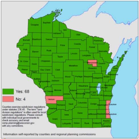
8 Zoning Counties Required to administer shoreland/wetland zoning May adopt general zoning in unincorporated areas Towns May adopt general zoning following adoption of village powers or if no county zoning Cities/Villages May adopt general zoning May adopt extra territorial zoning extending miles beyond boundaries May have shoreland or floodplain zoning required in some circumstances Information self reported to Wisconsin Department of Administration, November 30, 2010


9 Residential Industrial A zoning ordinance contains 2 parts: Conservancy Commercial Airport Map divides the community into districts 30 Buildable Area Text describes allowable uses and dimensional restrictions (i.e. lot size, density, setbacks, height, etc.)
 3.")
10 Uses for each district: 1. Permitted Use use is listed and allowed by right in all parts of a zoning district (granted by zoning administrator) 2. Conditional Use / Special Exception use is listed for a district and may be allowed if suited to the location (decided by zoning board, plan commission or governing body) 3. Unlisted or Prohibited Use use is not listed for the district or is expressly prohibited


11 Ex. Residential District Permitted Uses Conditional Uses Prohibited Uses


12 Sample Use Table P Permitted C Conditional Prohibited Zoning District A1 Intense Agriculture A2 Light Agriculture RR Rural Residential R1 Single Family R2 Multi Family C1 Commercial Livestock facility P C Residential poultry and beekeeping P P P C C Agricultural tourism C C C C Agriculture related business P P C C Roadside stand P P P C

13 Conditional Uses Must be listed for the zoning district Decision criteria also listed in the ordinance May be granted or denied Conditions may be attached

14 Conditional Uses AllEnergy v. Trempealeau County, 2017 WI 52 County identified 37 conditions for silica sand mine, then voted to deny permit based on public health, safety and aesthetic concerns. Wisconsin Supreme Court supported decision to deny. Dissenting opinion argued for less discretion for local governments.
15 Conditional Uses 2017 Wisconsin Act 67 created new rules for conditional use permits Counties Wis. Stat (5e) Towns Wis. Stat (4e), 60.62(4e) Cities and Villages Wis. Stat (7)(de))
16 Conditional Uses Definition Conditional use means a use allowed under a conditional use permit, special exception, or other special zoning permission, but does not include a variance.
17 Conditional Uses Process Class 2 notice, public hearing Decision by zoning board Appeal to circuit court Ordinance may specify alternate route: plan commission appeal to zoning board governing body appeal to circuit court
18 Conditional Uses Local government responsibilities Ordinance requirements and conditions must be reasonable, and to the extent practicable, measurable Conditions must relate to the ordinance purpose May limit permit duration, transfer, or renewal Decision to approve or deny the permit, and to attach conditions, must be supported by substantial evidence
19 Conditional Uses Substantial evidence Substantial evidence means facts and information, other than merely personal preferences or speculation, directly pertaining to the requirements and conditions an applicant must meet to obtain a conditional use permit, and that reasonable persons would accept in support of a conclusion.
20 Conditional Uses Applicant responsibilities Must demonstrate that the application and all requirements and conditions established by the local government relating to the conditional use are or shall be satisfied Must provide substantial evidence supporting the application and demonstrating that the requirements and conditions will be met
21 Conditional Uses Permit decision If an applicant for a conditional use permit meets or agrees to meet all requirements and conditions specified in the ordinance or imposed by the zoning board, the local government shall grant the conditional use permit
22 Ordinance review Review list of conditional uses for each district. Review ordinance standards that apply to each use or district. Discretion Legislative plan ordinance amendment Permit review Apply ordinance standards. Provide substantial evidence supporting decision to approve, deny, or attach conditions. Quasi-judicial variance conditional use plat review Administrative permitted uses


23 Ordinance Review Review conditional uses listed in ordinance Review standards, requirements and conditions listed in ordinance Consider general standards and those specific to a use Review purpose statements to make sure they support conditions you are likely to attach Consider adding a requirement that conditional use must be consistent with the comprehensive plan


24 Do you always want to grant the listed uses if requirements are met? On most sensitive slopes, soils? Next to all other uses allowed in these zoning districts? On all existing lots? Ex. Dog Kennel set minimum distance to residences If not, add additional requirements or remove them from the list of CUPs in districts where you don t always want to grant them Do you have standards for rezoning? Are they sufficient? Ex. Wedding Barn set minimum lot size to accommodate use and parking


25 Permit Review Review proposal against ordinance criteria Make sure conditions are reasonable, measurable and evidence based Determine credibility of information presented Create an adequate record of your decision Determine if you will grant or deny based on substantial evidence


26 Is this Reasonable, Measurable, Evidence based? Local government requires traffic impact analysis with projections based on ITE trip generation rates.

27 Is this Reasonable, Measurable, Evidence based? Local government requires that 100% of stormwater must be retained on site WI Act 243 Construction site erosion control and stormwater management ordinances May not require more than 90% of predevelopment runoff to be retained on site.

28 Is this Reasonable, Measurable, Evidence based? Certified wetland delineator verifies location of wetland on the property.

29 Reasonable, Measurable, Evidence based? Local government requires building or landscaping to be harmonious with surrounding properties. Aesthetics are recognized public concern, but more powerful when tied to health and safety. Create measurable standards or guidelines.

30 Reasonable, Measurable, Evidence based? Neighbor appears in opposition at public hearing citing decreased property values. Property values are a legitimate public purpose, but are not guaranteed by zoning. How do you measure? Is loss speculative? Is it a taking? What can you do to minimize loss?
31 Application and Decision Forms (See Handout)
32 Zoning Relief Mechanisms 1. Variance allowed violation of an ordinance standard (decided by zoning board of adjustment/appeals) 2. Appeal contested decision or interpretation of the zoning ordinance (decided by zoning board or circuit court) 3. Zoning Amendment change to the zoning ordinance map or text (adopted by governing body with advisory recommendation from plan commission)
33 Zoning Amendments Map amendment change to district boundaries Text amendment change to district regulations (i.e. allowed uses, setback, etc.) Legislative decision Must be reasonable and constitutional Consistent with Comprehensive Plan Other standards found in Zoning Ordinance
34 Sample Rezoning Standards The amendment is consistent with the comprehensive plan. The amendment will not be detrimental to property in the immediate vicinity or to the community as a whole. The amendment will not have a significant adverse impact on the ability to provide adequate public facilities or services The amendment will not have a significant adverse impact on the natural environment (i.e. air, water, noise, stormwater management, soils, wildlife, vegetation, etc.) or the impact could be mitigated by improvements on the site or in the immediate vicinity.
35 Consistency Requirement Beginning Jan. 1, 2010, new or amended zoning, land division and official mapping ordinances must be consistent with an adopted comprehensive plan Consistent means furthers or does not contradict the objectives, goals and policies contained in the comprehensive plan (2009 Wisconsin Act 372)

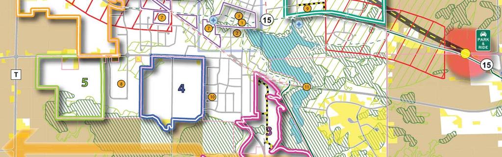
36 Consistency Examples Village of Black Creek Future Land Use Maps 10 and 20 year future land use maps show location, intensity and timing of development. Text describes plans for special development area. 10 years 20 years

37 Consistency Examples Village of Mount Horeb Future Land Use Map Plan specifies conditions under which growth may occur: development of this area is conditioned on the improvement of a new north south collector road
")

38 Consistency Examples Village of DeForest Future Land Use Map (2016) Future land uses extend beyond municipal boundaries to cooperative boundary lines.

39 Consistency Examples Village of DeForest text provides guidance for zoning


40 Sauk Prairie (Town and 2 Villages)
 Single family Multi family Commercial Industrial")
 Limited")
41 T. Fond du Lac Future Land Use 2040 Priority Mixed Use (88% growth) Single family Multi family Commercial Industrial Sewer/Water Rural Residential (8% growth) Single family Well/Septic Farmland Preservation (4% growth) Limited residential Large lots

42 Consistency Examples Village of Hortonville Future Land Use Map Map drawn in bubble fashion showing priority areas for future development within village and extraterritorial jurisdiction.

43 Village of Hortonville
44 From Marathon County and Town Comprehensive Plans: Each local jurisdiction must make land use decisions that are consistent with their own comprehensive plan. The decision to approve a zoning change must be based on the adopted comprehensive plan, and specifically, the future land use map. If the requested zoning is consistent with the land use designation on the property it should be approved, unless unique circumstances indicate the rezoning would negatively impact surrounding properties or the community. If the requested zoning is not consistent, the community should consider denying the request. If the community believes the requested zoning is appropriate in the specific location and would benefit the community, the change can be approved, but the land use map should be amended to establish land use and zoning consistency.
45 Petition for ordinance amendment Notice of public hearing & notice to affected towns Public hearing on map and/or text amendment Zoning committee recommendation to county board Governing body vote to modify, adopt or deny Amendment goes into effect and is published Rezone Process Towns under county zoning: Recommended: Towns provide recommendation to county prior to public hearing. Within 10 days of public hearing: Towns may object to changes outside shoreland/floodplain areas. If town disapproves, zoning committee must revise proposal or recommend denial. Within 40 days of county vote: If majority of affected towns disapprove, amendment does not take effect.
46 Recommendations

47 Land Division and Subdivision Ordinances
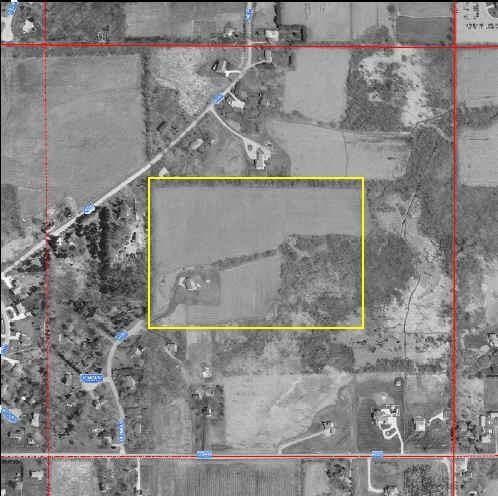
48 Is a subdivision plat required? Scenario 1 Jack and Jill propose creating 5 lots that are each 1.5 acres in size. 160 acre parcel YES!


49 State Subdivision Law State provides minimum standards for subdivisions (Wis. Stat. ch. 236) Subdivision = creation of 5 or more parcels of 1½ acre or less within a 5 year period State reviews for surveying, layout, mapping and plat submittal requirements
 Most restrictive provision applies Terminology: State subdivision/plat County subdivision/plat Minor")
50 Local Land Division Authority Counties, towns, cities, villages may also adopt local ordinances (Wis. Stat ) Most restrictive provision applies Terminology: State subdivision/plat County subdivision/plat Minor subdivision/csm
51 Local ordinances may have more restrictive surveying, monumenting, mapping and approval requirements. but may not have more restrictive time limits, deadlines, or notice requirements or alter other provisions that provide protections for the subdivider. (2009 Wisconsin Act 376)
52 Objecting Authorities The following agencies have authority to certify or object to state defined subdivision plats: WI Department of Administration all state defined subdivisions are reviewed for compliance with surveying, layout, mapping and plat submittal requirements. (Wis. Stat. 236) WI Department of Transportation subdivisions that abut a state trunk or connecting highway are reviewed for public safety issues and preservation of public interests/investments. (Trans 233) County Planning Agency 18 counties review plats located in cities/villages for conflicts with parks, highways, airports, schools, and other planned public developments. (Wis. Stat (2)(b))
53 Approving Authorities The following units of government have authority to approve of state defined subdivision plats: County Planning Agency if the subdivision is located in an unincorporated area of the county Town Board if the subdivision is located in the town or an area whose annexation is being contested by the town City Council/Village Board if the subdivision is located in a city/village or its extraterritorial plat review jurisdiction
54 Who has plat review authority? Scenario 1 revisited The subdivision is located in a town approximately 1 mile from the nearest village. The county has a subdivision ordinance. 160 acre parcel The town and village do not. Answer: state, county and town

55 Extraterritorial plat approval Extends 3 miles from a first, second, or third class city 1.5 miles from a fourth class city or village Overlapping jurisdiction divided at equidistant point A city or village must have an adopted subdivision ordinance or official map to exercise this authority It may not require public improvements or deny approval on the basis of use (extraterritorial zoning)
56 Is a subdivision plat required? Scenario 2 Jack and Jill propose creating 25 lots ranging in size from 5-10 acres. 160 acre parcel
57 Is a subdivision plat required? It depends on local regulations No. parcels Parcel size Time State 5 or more 1.5 acres or less 5 years Dane Co. 5 or more 1.5 acres or less 5 years Winnebago Co. 5 or more 5 acres or less 5 years Outagamie Co. 5 or more Any size 5 years No No Maybe Yes

58 Local Plat Review Options The county asks Jack and Jill to meet informally with staff prior to submitting a final plat. They do not require a preliminary plat. Is this allowed? Yes
59 1 2 3 Pre Application Conference Informal review intended to spot problems upfront If requested or required by local ordinance Preliminary Plat Approval If required by local ordinance OR submitted by applicant Act within 90 days Final Plat Approval Submission of detailed engineering and design drawings that comply with Wis. Stat. Ch. 236 Act within 60 days Final plat entitled to approval if it complies with local plans/ordinance, meets objections of state agencies, and substantially conforms with an approved preliminary plat.

60

61 Preliminary Plat drawn to scale including location of streets, utility lines, parks, storm drainage, sewer and water lines, etc.

62 Final Plat including subdivision name, legal description, street names, boundaries, measurements and other engineering data. Must follow accepted printing, layout and binding standards. Accompanied by: Surveyor s certificate of compliance, Owner s certificate of dedication, Consent of mortgagee, Certificate of taxes paid, Description of easements, and Local government approvals.
 Public improvements (provision of street lights, curb, gutter, etc.")
 Preservation of natural features (steep slopes, shorelands, wetlands, forests, etc.")
63 What can you review for? Layout, access and safety (sight lines, turning radius, emergency vehicle access, etc.) Public improvements (provision of street lights, curb, gutter, etc.) Efficient use of public facilities/services (road length, proximity to existing utilities, etc.) Preservation of natural features (steep slopes, shorelands, wetlands, forests, etc.) Compatibility with adjacent uses (use, intensity, scale, etc.) 160 acre parcel
64 What can you review for? Plat approval may only be conditioned on: Compliance with local ordinances in place at time of submittal Consistency with comprehensive plan or official map Provision of public improvements or financial guarantees (contained in a town/village/city subdivision ordinance) Satisfaction of objections raised by state agencies Other requirements of Wis. Stat. Ch. 236 Short answer items contained in an adopted comprehensive plan, ordinance or official map.

65 Who does what? Subdivision plats must be referred to the plan commission for review and recommendation. The governing body may delegate preliminary or final plat approval authority to the plan commission. Final plats dedicating streets, highways or other lands must be approved by the governing body. (Wis. Stat (5) and (3))

66 Certified Survey Maps Expedited process for land divisions that do not meet state or local definition of subdivision (based on number or size): Survey, monument, and map by professional land surveyor CSM dedicating streets or other land must be submitted to governing body 90 days to act CSM filed with county register of deeds
(ar)) Local governments may allow more")


67 Expanded Use of CSMs (Wis. Stat (1)(ar)) Local governments may allow more than 4 parcels on a CSM if they: Have an established planning agency Pass an ordinance or resolution Specify a maximum number of parcels Land is zoned commercial, industrial or mixed use


68 Homework Visit some sites post development and review against approved plans How would you amend your process or standards to provide better outcomes?
69


70 Procedural Responsibilities Fair and Impartial Decision Making Findings of Fact and Records Legally Defensible Decisions
71 All officials must comply with the Open Meetings Law and Public Notice requirements, and avoid statutory Conflicts of Interest. Discretion Legislative plan ordinance amendment Refer to Plan Commission Handbook Chapter 2: Procedural Responsibilities Quasi-judicial variance conditional use plat review Administrative permitted use
 A local official may not use a public position for the private benefit or financial gain of: the individual")
72 Statutory Conflicts of Interest (Wis. Stat. s and s ) A local official may not use a public position for the private benefit or financial gain of: the individual immediate family members organizations they are associated with
73 Quasi judicial Decision Makers Discretion Legislative plan ordinance amendment Impartial decision-makers may not prejudge or exhibit bias. Use professional judgment to apply ordinance standards. Record your rationale. Quasi-judicial variance conditional use plat review Administrative permitted use
74 Bias of Local Officials Keen v. Dane County, 2004 WI App 26 Payne & Dolan applied for a conditional use permit for a gravel pit CUP was granted over the protests of neighbors Neighbors appealed
75 Biased?? Decision maker #1 A letter was submitted as part of the CUP application stating: Payne and Dolan has always stood out above the rest in their efforts and success in being a good corporate citizen and caretaker of the land. Decision maker #2 Advocate Risk of bias too high Had leased his land to Payne and Dolan for the operation of a gravel pit. Prior, independent business transaction
 must not harbor bias, or an impermissibly high risk of bias, or prejudge the application Keen v.")
76 Local officials deciding on quasi judicial matters (i.e. conditional use, variance, etc.) must not harbor bias, or an impermissibly high risk of bias, or prejudge the application Keen v. Dane County, 2004 WI App 26

77 Recuse yourself from decisions that present a conflict of interest or bias (or appearance of bias) Not the same as abstaining (not voting) Do not participate in decision or discussion leading up to decision Physically separate yourself from the decisionmaking body if possible If you want to provide testimony, do so as a member of the audience

78 Ex parte Communication = discussion regarding a pending matter not included in the public record. Quasi judicial decisionmakers should: avoid it, disclose it, and encourage citizens to make important information part of the public record.

79 Recording Decisions Keen v. Dane County, 2004 WI App 26 Local ordinance listed 10 factors to consider when deciding a CUP Purpose of zoning district Availability of alternative locations Compatibility with existing or permitted use on adjacent lands
80 Recording Decisions Keen v. Dane County, 2004 WI App 26 After a very lengthy discussion the CUP was granted with 61 conditions But the decision did not refer to the 10 factors in the ordinance A record without any reference to the factors in the ordinance is not sufficient

81 Recording Decisions Lamar Central Outdoor v. Board of Zoning Appeals of the City of Milwaukee, 2005 Wisconsin Supreme Court Lamar applied for a variance to raise a billboard above the City s maximum sign height BOA denied variance stating that the variance criteria were not met
82 Decision makers must express, on the record: 1. the statutory or ordinance criteria under which the application is decided and 2. the reasons the criteria are or are not satisfied The reasons do not need to appear in a written decision but should appear somewhere in the public record (meeting minutes, transcript, recording, etc.) If appealed, a judge will review the record and needs to be able to follow your reasoning
83 Decision Forms
84 Legally Defensible Decisions Courts defer to local decision makers when these tests are met: 1) Subject matter jurisdiction Did the body decide a matter that it is empowered by statute or ordinance to act on? 2) Proper procedures Did the body follow proper procedures (open meeting law, public notice, hearing, record of decision, etc.)? 3) Proper standards Did the body apply proper standards in making the decision? (refer to standards for rezonings, CUPs, plat review) 4) Rational basis for the decision Could a reasonable person have reached this conclusion? 5) Evidence in the record Do facts in the record of the proceedings support the decision?
85 Homework 1. Review application forms Do they prompt applicant to prove they meet the standards? 2. Review recommendation forms Do they prompt the town or plan commission to address the ordinance standards? 3. Review decision forms Do they prompt decision makers to follow the standards? 4. Review decision standards and procedures Are they adequate? Do you follow them?
86 Recommended Resources Sample guides, checklists and forms in handbook

87 Recommended Resource Plan Commission Handbook (CLUE, 2012) ap/clue/pages/publications resources/plancommissions.aspx I. Introduction to the Plan Commission II. Procedural Responsibilities III. Community Planning IV. Public Participation V. Plan Implementation V. Ordinance Administration VI. Zoning Regulations VII. Subdivision Regulations Includes forms, worksheets, glossaries and recommended resources


88 Thank You! Rebecca Roberts Center for Land Use Education ap/clue
Workshop for Local Planning and Zoning Officials. Rebecca Roberts Center for Land Use Education UW Stevens Point/Extension
 Workshop for Local Planning and Zoning Officials Rebecca Roberts Center for Land Use Education UW Stevens Point/Extension Roles and Governing Body Responsibilities Staff Boards/Committees Land Use Tools
Plan Commission Workshop. Rebecca Roberts Center for Land Use Education UW-Stevens Point/Extension
 Plan Commission Workshop Rebecca Roberts Center for Land Use Education UW-Stevens Point/Extension Tonight s Presentation Role of the plan commission, governing body, and other land use officials Community
Plan Commission Workshop. Rebecca Roberts Center for Land Use Education UW Stevens Point/Extension
 Plan Commission Workshop Rebecca Roberts Center for Land Use Education UW Stevens Point/Extension Tonight s Presentation Role of Local Officials Land Use Decision Making Procedural Responsibilities Roles
Town-County Relationships in Zoning. Rebecca Roberts Center for Land Use Education UW-Stevens Point/Extension
 Town-County Relationships in Zoning Rebecca Roberts Center for Land Use Education UW-Stevens Point/Extension Tonight s Agenda Zoning basics Town role in county zoning decisions Responsibilities involved
Chapter 8 INTRODUCTION.2. STATE SUBDIVISION REGULATIONS 2 State Review (Objecting Authorities) Local Review (Approving Authorities) Basis for Approval
 Local Review (Approving Authorities) Basis for Approval") INTRODUCTION.2 STATE SUBDIVISION REGULATIONS 2 State Review (Objecting Authorities) Local Review (Approving Authorities) Basis for Approval LOCAL LAND DIVISION REGULATIONS 6 General Organization of a Subdivision
INTRODUCTION.2 STATE SUBDIVISION REGULATIONS 2 State Review (Objecting Authorities) Local Review (Approving Authorities) Basis for Approval LOCAL LAND DIVISION REGULATIONS 6 General Organization of a Subdivision
Local Government and Industrial Sand Mining. Wisconsin has no known petroleum deposits, but the state has lots of sand and the right kind of sand.
 Local Government and Industrial Sand Mining Wisconsin has no known petroleum deposits, but the state has lots of sand and the right kind of sand. Sandstone formations DNR data: http://dnr.wi.gov/topic/mines/ismmap.html
Town zoning: A good option for your town?
 Photo credit: Landslides Aerial Photography Town zoning: A good option for your town? Lynn Markham Town of Auburn May 27, 2015 Main points 1. Zoning is one tool to implement community plans 2. What does
Dane County Land Use Handbook
 Dane County Land Use Handbook Dane County Board of Supervisors Prepared by The Office of the County Board Last revision 4/6/98 Summary September 15, 1997 Dane County has land area of 1,202 square miles,
Burnett County, WI LAND USE VARIANCE APPLICATION, EXPLANATION, & REQUIREMENTS
 Burnett County, WI LAND USE VARIANCE APPLICATION, EXPLANATION, & REQUIREMENTS A variance is a relaxation of a standard in a land use ordinance. Variances are decided by the Board of Adjustment/Appeals
CONDITIONAL USE PERMIT (CUP)
") CONDITIONAL USE PERMIT (CUP) LAND DEVELOPMENT APPLICATION FORM DEPARTMENT OF PLANNING 300 East Main Street, Sun Prairie, WI 53590-2227 (608)825-1107 FAX (608)825-1194 Applications will not be processed
CONDITIONAL USE PERMIT (CUP) LAND DEVELOPMENT APPLICATION FORM DEPARTMENT OF PLANNING 300 East Main Street, Sun Prairie, WI 53590-2227 (608)825-1107 FAX (608)825-1194 Applications will not be processed
Certified Survey Map (CSM) Submittal Updated: 6/29/18
 Submittal Updated: 6/29/18") Certified Survey Map (CSM) Submittal Updated: 6/29/18 Town of Middleton 7555 W. Old Sauk Road Verona, WI 53593-9700 Phone: 608-833-5887 Fax: 608-833-8996 info@town.middleton.wi.us The Town of Middleton
Certified Survey Map (CSM) Submittal Updated: 6/29/18 Town of Middleton 7555 W. Old Sauk Road Verona, WI 53593-9700 Phone: 608-833-5887 Fax: 608-833-8996 info@town.middleton.wi.us The Town of Middleton
APPLICATION FOR CONDITIONAL USE PERMIT
 Receipt No. Fee Date Date Permit Issued: Certificate of Compliance: Date DOOR COUNTY LAND USE SERVICES 421 Nebraska Street Door County Government Center Sturgeon Bay, Wisconsin 54235 (920) 746-2323 - FAX
Town of Norwich, Vermont SUBDIVISION REGULATIONS
 Town of Norwich, Vermont SUBDIVISION REGULATIONS Adopted: August 6, 2002 Amended: February 8, 2006 Prepared by Norwich Planning Commission with the assistance of: Burnt Rock Inc. A ssociates in Community
2/22/2016. Planning and Zoning. David Owens March 2016 SOME CONTEXT
 Planning and Zoning David Owens March 2016 SOME CONTEXT 1 N.C. Population 1900 1.6 million 1950 2.4 million 2015 10 million 2 3 Population Growth Housing Units/ Square Mile Source: UNC Carolina Population
Burnett County, WI SUBDIVISION VARIANCE APPLICATION, EXPLANATION, & REQUIREMENTS PROCESS (NOTE: PLEASE READ ENTIRE APPLICATION BEFORE PROCEEDING)
") Burnett County, WI SUBDIVISION VARIANCE APPLICATION, EXPLANATION, & REQUIREMENTS A variance is a relaxation of a standard in a land use ordinance. Subdivision variances are decided by the Land Use and
Burnett County, WI SUBDIVISION VARIANCE APPLICATION, EXPLANATION, & REQUIREMENTS A variance is a relaxation of a standard in a land use ordinance. Subdivision variances are decided by the Land Use and
CHAPTER 3 PRELIMINARY PLAT
 10-3-1 10-3-3 SECTION: CHAPTER 3 PRELIMINARY PLAT 10-3-1: Consultation 10-3-2: Filing 10-3-3: Requirements 10-3-4: Approval 10-3-5: Time Limitation 10-3-6: Grading Limitation 10-3-1: CONSULTATION: Each
A Guide to the Municipal Planning Process in Saskatchewan
 A Guide to the Municipal Planning Process in Saskatchewan A look at the municipal development permit and the subdivision approval process in Saskatchewan May 2008 Prepared By: Community Planning Branch
TOWN OF ROXBURY PLANNING BOARD
 UPDATED: APRIL 2011 TOWN OF ROXBURY PLANNING BOARD Applicant s Guide for Subdivision Review The Town Planning Board administers the subdivision review process. This guide has been prepared in order to
ARTICLE III GENERAL PROCEDURES, MINOR PLANS AND FEE SCHEDULES
 ARTICLE III GENERAL PROCEDURES, MINOR PLANS AND FEE SCHEDULES 301. Prior to Submission a. Copies of this Ordinance shall be available on request, at cost, for the use of any person who desires information
ARTICLE 1 GENERAL PROVISIONS
 ARTICLE 1 GENERAL PROVISIONS SECTION 100 TITLE This Ordinance shall be known and cited as the "Rice Township Subdivision and Land Development Ordinance." SECTION 101 AUTHORITY Rice Township is empowered
Dane County Planning & Development Land Division Review
 Dane County Planning & Development Land Division Review Date: June 26, 2012 To: Zoning & Land Regulation Committee From: Daniel Everson, Land Division Review Re: Revere Trails (preliminary plat) Town of
(if more than one, give square footage for each) ANNEXATION LOT LINE Adjustments PRE/FINAL PLAT SPECIAL USE PERMIT
 ANNEXATION LOT LINE Adjustments PRE/FINAL PLAT SPECIAL USE PERMIT") Planning Commission Application Building & development office 915 Third ST. Rawlins WY ph. 307-328-4599 fax. 307-328-4590 PROJECT REVIEW: GENERAL INFORMATION Project name: OFFICE USE ONLY Site address
Planning Commission Application Building & development office 915 Third ST. Rawlins WY ph. 307-328-4599 fax. 307-328-4590 PROJECT REVIEW: GENERAL INFORMATION Project name: OFFICE USE ONLY Site address
THE COUNTY BOARD OF SUPERVISORS OF THE COUNTY OF DOUGLAS DOES ORDAIN AS FOLLOWS:
 8.1 SUBDIVISION CONTROL ORDINANCE THE COUNTY BOARD OF SUPERVISORS OF THE COUNTY OF DOUGLAS DOES ORDAIN AS FOLLOWS: SECTION I. GENERAL INTERPRETATION This ordinance shall not repeal, impair or modify private
FACT SHEET. The Town Plan Commission
 Page 1 FACT SHEET Number 16 The Town Plan Commission Revised March 2001 This Fact Sheet addresses the following major topics: Why Establish a Town Plan Commission? What is the Relationship Between the
Article 6: Planned Unit Developments
 LUDC 2013 GARFIELD COUNTY, COLORADO Article 6: Planned Unit Developments ARTICLE 6 PLANNED UNIT DEVELOPMENTS TABLE OF CONTENTS DIVISION 1. GENERAL.... 1 6-101. GENERAL PROVISIONS.... 1 A. Purpose....
Zoning Most Frequently Asked Questions
 Zoning Most Frequently Asked Questions Zoning is needed to achieve the following: Orderly development consistent with utility location/capacity, street network, public services; Compatible land uses in
LETTER OF APPLICATION
 Description of Proposed Land Division: LETTER OF APPLICATION The proposed land division would split a 1.94 acres rectangular lot into two lots. The general configuration would have one lot in front of
Guide to Minor Developments
 Guide to Minor Developments Introduction The Douglas County (DCD) is committed to providing open, transparent application processes to the public. This Guide is provided to assist anyone interested in
Guide to Combined Preliminary and Final Plats
 Guide to Combined Preliminary and Final Plats Introduction The Douglas County is committed to providing open, transparent application processes to the public. This Guide is provided to assist anyone interested
A GUIDE TO PROCEDURES FOR: SUBDIVISIONS & CONDOMINIUM CONVERSION
 A GUIDE TO PROCEDURES FOR: SUBDIVISIONS & CONDOMINIUM CONVERSION A GUIDE TO PROCEDURES FOR: SUBDIVISIONS (TENTATIVE MAPS) PURPOSE Definition: A subdivision is defined as the division of any improved or
4/3/2018. City Council City Hall Wilmington, North Carolina Dear Mayor and Councilmembers:
 ITEM PH2 OFFICE OF THE CITY MANAGER (910) 341-7810 FAX (910)341-5839 TDD (910)341-7873 4/3/2018 City Council City Hall Wilmington, North Carolina 28401 Dear Mayor and Councilmembers: Attached for your
Town of. River Falls. Land Use Element Vierbicher Associates, Inc
 Town of River Falls 2005 Vierbicher Associates, Inc Contents Contents s. 66.1001(2)(h) Wis. Stats................................................. ii Introduction................................................................
Understanding the Conditional Use Process
 Understanding the Conditional Use Process The purpose of this document is to explain the process of applying for and obtaining a conditional use permit in the rural unincorporated towns of Dane County.
R e z o n i n g A p p l i c a t i o n S u b m i s s i o n R e q u i r e m e n t s
 H O R R Y C O U N T Y P L A N N I N G & Z O N I N G 1 3 0 1 2 N D A V E., S U I T E 1 D - 0 9 C O N W A Y, S. C. 2 9 5 2 6 P H O N E : 8 4 3. 9 1 5. 5 3 4 0 F A X : 8 4 3. 9 1 5. 6 3 4 1 R e z o n i n
MAJOR RESIDENTIAL AND NONRESIDENTIAL SUBDIVISIONS
 Lawrence-Douglas County MAJOR RESIDENTIAL AND NONRESIDENTIAL SUBDIVISIONS Preliminary Plats The applicant shall schedule a Pre-Application meeting with Planning Staff at least seven (7) working days prior
MIDWAY CITY Municipal Code
 MIDWAY CITY Municipal Code TITLE 9 ANNEXATION CHAPTER 9.01 PURPOSE CHAPTER 9.02 GENERAL REQUIREMENTS CHAPTER 9.03 PROPERTY OWNER INITIATION OF ANNEXATION CHAPTER 9.04 PROCEDURES FOR CONSIDERATION OF PETITION
DENTON Developer's Handbook
 DENTON Developer's Handbook A guide for land development in the City of Denton Department of Development Services 2017 2 Table of Contents 1. City of Denton Development Process...5 Role of the Development
O-I (Office-Institutional) and AG-1(Agricultural)
 and AG-1(Agricultural)") PROPERTY INFORMATION ADDRESS 3503 and 3505 Bethany Bend DISTRICT, LAND LOTS 2/1 973 and 974 OVERLAY DISTRICT State Route 9 PETITION NUMBERS EXISTING ZONING O-I (Office-Institutional) and AG-1(Agricultural)
PROPERTY INFORMATION ADDRESS 3503 and 3505 Bethany Bend DISTRICT, LAND LOTS 2/1 973 and 974 OVERLAY DISTRICT State Route 9 PETITION NUMBERS EXISTING ZONING O-I (Office-Institutional) and AG-1(Agricultural)
Town of Prairie du Sac Sauk County, WI. Land Division Ordinance 07-3
 Town of Prairie du Sac Sauk County, WI Land Division Ordinance 07-3 1.01 DISCLAIMER (1) Multiple Jurisdictions. All persons reviewing the provisions of this Ordinance should be aware that the Town of Prairie
Josephine County, Oregon
 Josephine County, Oregon PLANNING OFFICE 700 NW Dimmick Street, Suite C, Grants Pass OR 97526 (541) 474-5421 / Fax (541) 474-5422 E-mail: planning@co.josephine.or.us VARIANCE APPLICATION (General Development
CHAPTER 10 Planned Unit Development Zoning Districts
 CHAPTER 10 Planned Unit Development Zoning Districts Section 10.1 Intent and Purpose The Planned Unit Development (PUD) districts are intended to offer design flexibility for projects that further the
Town of Lisbon, Maine SUBDIVISION REVIEW APPLICATION
 Date Received: Fee Paid (amount): Applicant: Town of Lisbon, Maine SUBDIVISION REVIEW APPLICATION Subdivision Name/Title: This application must be received at the Town Office by close of business on the
ORDINANCE NO. _4.06 AN ORDINANCE TO ESTABLISH BUILDING SITE REGULATIONS SECTION A PURPOSE AND INTENT
 ORDINANCE NO. _4.06 AN ORDINANCE TO ESTABLISH BUILDING SITE REGULATIONS SECTION A PURPOSE AND INTENT This Ordinance provides minimum regulations, provisions and requirements for safe, aesthetically pleasing
FREQUENTLY USED PLANNING & ZONING TERMS
 City Of Mustang FREQUENTLY USED PLANNING & ZONING TERMS Abut: Having property lines, street lines, or zoning district lines in common. Accessory Structure: A structure of secondary importance or function
The Basics of Boundary Agreements. May 29, 1997
 The Basics of Boundary Agreements May 29, 1997 Wisconsin Statutes provide structures for cooperative action between municipalities including general agreements, cooperative plans, and municipal revenue
Discretion Associated with Zoning Decisions
 12 Chapter Discretion Associated with Zoning Decisions Zoning decisions are typically divided into three categories (administrative, quasi-judicial and legislative) depending on the type of decision made
SUBDIVISION APPLICATION CHECKLIST SKETCH PLAN PRELIMINARY PLAT FINAL PLAT
 RECEIVED STAMP SUBDIVISION APPLICATION CHECKLIST SKETCH PLAN PRELIMINARY PLAT FINAL PLAT A checklist of background information and submission requirements for processing of a sketch plan, preliminary plat
ARTICLE 1 GENERAL PROVISIONS AUTHORITY AND ADMINISTRATION RESPONSIBILITIES OF DEVELOPER AND PLANNING COMMISSION
 ARTICLE 1 GENERAL PROVISIONS 103.101. TITLE 103.102. AUTHORITY AND ADMINISTRATION 103.103. PURPOSE 103.104. INTERPRETATION 103.105. RESPONSIBILITIES OF DEVELOPER AND PLANNING COMMISSION 103.106. JURISDICTION
SECTION 10 STANDARD PLATS
 SECTION 10 - STANDARD PLATS Subdivision 1: Purpose Standard Plats allow the subdivision of land into lots smaller than the minimum metes and bounds size in the zoning district, and control road development
WAYNE COUNTY, UTAH SUBDIVISION ORDINANCE
 WAYNE COUNTY, UTAH SUBDIVISION ORDINANCE A LAND USE ORDINANCE OF WAYNE COUNTY As Adopted by the Wayne County Board of County Commissioners Effective January 01, 2011 Prepared by: PLANNING AND DEVELOPMENT
Medical Marijuana Special Exception Use Information
 Medical Marijuana Special Exception Use Information The Special Exception Use information below is a modified version of the Unified Development Code. It clarifies the current section 5:104 Special Exceptions
SECTION 4: PRELIMINARY PLAT
 SECTION 4: PRELIMINARY PLAT After the completion of the sketch plan process, if submitted, the owner or developer shall file with the City an application for preliminary plat. The preliminary plat stage
MAJOR SUBDIVISION PRELIMINARY PLAT CHECKLIST
 TOWNSHIP OF EGG HARBOR PLANNING BOARD/ZONING BOARD OF ADJUSTMENT 3515 BARGAINTOWN ROAD EGG HARBOR TOWNSHIP, NJ 08234 MAJOR SUBDIVISION PRELIMINARY PLAT CHECKLIST The following checklist is designed to
HOW TO APPLY FOR A USE PERMIT
 HOW TO APPLY FOR A USE PERMIT MENDOCINO COUNTY PLANNING AND BUILDING SERVICES What is the purpose of a use permit? Throughout the County, people use their properties in many different ways. They build
MINOR SUBDIVISION INFORMATION
 A. POINTS OF CONTACT: MINOR SUBDIVISION INFORMATION Surveyor: Address: Phone #: Fax # E-Mail Address: Representative (If different from applicant): Address: Phone #: Fax # E-Mail Address: B. GENERAL INFORMATION:
MAJOR RESIDENTIAL AND NONRESIDENTIAL SUBDIVISIONS
 MAJOR RESIDENTIAL AND NONRESIDENTIAL SUBDIVISIONS Final Plats The applicant shall schedule a Pre-Application meeting with Planning Staff at least seven (7) working days prior to submittal of the application.
Contributing Authors:
 chapter 10 Site/Development Plan Review Contributing Authors: Jackie Turner, AICP, LEED AP and Robert Thompson, AICP - Current Authors Robert S. Cowell, Jr., AICP - Previous Author In this chapter... Introduction
Stem Zoning Ordinance
 Stem Zoning Ordinance Town of Stem North Carolina September 21, 2016 (Supersedes Stem Zoning Ordinance 04/21/2014) ZoningORD_Final_09-21-16.docx Authority Article 1. General and Legal Provisions... 9
Potsdam Local Government Conference October 10, 2017
 Potsdam Local Government Conference October 10, 2017 Presented by Jason Pfotenhauer, St. Lawrence County Planning Office Congratulations on your appointment! Planning Board Basics Keeping up the Momentum
610 LAND DIVISIONS AND PROPERTY LINE ADJUSTMENTS OUTSIDE A UGB
 ARTICLE VI: LAND DIVISIONS AND PROPERTY LINE ADJUSTMENTS VI-21 610 LAND DIVISIONS AND PROPERTY LINE ADJUSTMENTS OUTSIDE A UGB 610-1 Property Line Adjustments (Property Line Relocation) A property line
THE SUBDIVISION AND LAND DEVELOPMENT REVIEW PROCESS
 THE SUBDIVISION AND LAND DEVELOPMENT REVIEW PROCESS INTRODUCTION: Howard County Subdivision and Land Development Regulations are intended to promote the health, safety and general welfare of County residents.
LETTER OF APPLICATION
 Description of Proposed Land Division: LETTER OF APPLICATION The proposed land division would split a 1.94 acres rectangular lot into two lots. The general configuration would have one lot in front of
APPLICATION FOR MAJOR SUBDIVISION APPROVAL (PRELIMINARY PLAT)
") 209 S. Main Street Marysville, Ohio 43040 Phone: (937) 645-7350 Fax: (937) 645-7351 www.marysvilleohio.org APPLICATION FOR MAJOR SUBDIVISION APPROVAL (PRELIMINARY PLAT) *** IMPORTANT INFORMATION ~ Please
209 S. Main Street Marysville, Ohio 43040 Phone: (937) 645-7350 Fax: (937) 645-7351 www.marysvilleohio.org APPLICATION FOR MAJOR SUBDIVISION APPROVAL (PRELIMINARY PLAT) *** IMPORTANT INFORMATION ~ Please
Appendix C SUMMARY OF LAND USE-RELATED EXTRATERRITORIAL AUTHORITIES
 #235120-2 NMA/RMB 3/13/17 Appendix C SUMMARY OF LAND USE-RELATED EXTRATERRITORIAL AUTHORITIES Introduction Cities and villages in Wisconsin have several types of extraterritorial authority that may affect
SECTION 16. "PUD" PLANNED UNIT DEVELOPMENT OVERLAY DISTRICT
 SECTION 6. "PUD" PLANNED UNIT DEVELOPMENT OVERLAY DISTRICT Subsection. Purpose. This district is established to achieve the coordinated integration of land parcels and large commercial and retail establishments
Hello Plat Review, I have a question.
 Hello Plat Review, I have a question. January 24, 2018 2018 Surveyors' Institute 1 When do I have to do a subdivision plat? January 24, 2018 2018 Surveyors' Institute 2 236.02 (12) Definitions. Requires
NOTICE OF STATE MANDATED FEE! Approx. = $900 per Acre to Rezone A-1 Land
 NOTICE OF STATE MANDATED FEE! Approx. = $900 per Acre to Rezone A-1 Land STATE OF WISCONSIN MANDATED FARMLAND PRESERVATION ZONE DISTRICT REZONE CONVERSION FEE Beginning January 1, 2010, the State of Wisconsin
Boyertown Borough and Colebrookdale and Pike Townships Joint Zoning Ordinance
 Boyertown Borough and Colebrookdale and Pike Townships Joint Zoning Ordinance Berks County, Pennsylvania Effective Date - November 7, 2010 This Ordinance was prepared under the direction of the Boyertown
13-2 SUBDIVISION PLANS AND PLATS REQUIRED EXCEPTIONS Subdivision Plats Required To be Recorded
 ARTICLE XIII SUBDIVISIONS 13-1 INTENT AND PURPOSE 13-1-1 Intent: It is the intent of the County Commission through the adoption of this Article to more fully avail itself of the power granted under 17-27-601
Guide to Preliminary Plans
 Guide to Preliminary Plans Introduction The Douglas County is committed to providing open, transparent application processes to the public. This Guide is provided to assist anyone interested in the procedures
CITY OF GROVER BEACH COMMUNITY DEVELOPMENT DEPARTMENT Tentative Map Checklist
 CITY OF GROVER BEACH COMMUNITY DEVELOPMENT DEPARTMENT Tentative Map Checklist The following list includes all of the items you must submit for a complete application. Some specific types of information
** If your lot does not meet the requirements above, please read Sec below
 Sec. 13-1-60 Zoning District Dimensional Requirements. For the Zoning Dept To Issue a Land Use Permit The Following Dimensions are Required. Minimum Side and Rear Yards s Lakes Classification Minimum Class
Draft Zoning Changes for the 2nd Planning Board Public Hearing, January 22, 2018.
 Draft Zoning Changes for the 2nd Planning Board Public Hearing, January 22, 2018. No changes were made at the 1st Public Hearing. Proposed wording for the 1 st Public Hearing in red, eliminated text in
FINAL PLAT APPLICATION
 FINAL PLAT APPLICATION (Page 1 of 3) LEGAL OWNER(s): NAME: STREET ADDRESS OWNER(s): CITY, STATE, ZIP CODE: PHONE NUMBER: BILLING ADDRESS: NAME OF ENGINEER/SURVEYOR: Engineer/Surveyor Address, Phone: PROPERTY
Planning 101: Annexation and Municipal & County Zoning. Annexation Title 7, Chapter 2, Parts Required Provision of Services
 Planning 101: Annexation and Municipal & County Zoning September 9, 2013 Chris Saunders, AICP Annexation Title 7, Chapter 2, Parts 42-47 Brings new territory into the boundaries of a municipality All annexations
Township of Collier 2418 Hilltop Road Presto, PA 15142
 Township of Collier 2418 Hilltop Road Presto, PA 15142 Fees: Major: 2 checks $600 + $50 per lot & $1700 Escrow) APPLICATION FOR SUBDIVISION major FINAL only Plans must be folded Rolled plans will not be
Walworth County Farmland Preservation Plan Update, Chapter 1 Plan Summary (Cover Document)
") Background Walworth County Farmland Preservation Plan Update, 2012 Chapter 1 Plan Summary (Cover Document) For over 30-years, the Wisconsin Farmland Preservation Program has served to preserve Walworth
Background Walworth County Farmland Preservation Plan Update, 2012 Chapter 1 Plan Summary (Cover Document) For over 30-years, the Wisconsin Farmland Preservation Program has served to preserve Walworth
Do I Need a Municipal/Land Use Attorney?
 Do I Need a Municipal/Land Use Attorney? Municipal Regulation In 1789, Benjamin Franklin famously wrote that in the world nothing can be said to be certain except death and taxes. Now, more than 200 years
ARTICLE 15 - PLANNED UNIT DEVELOPMENT
 Section 15.1 - Intent. ARTICLE 15 - PLANNED UNIT DEVELOPMENT A PUD, or Planned Unit Development, is not a District per se, but rather a set of standards that may be applied to a development type. The Planned
WOODLAND AREA GENERAL PLAN URBAN DEVELOPMENT POLICY
 APPENDIX A WOODLAND AREA GENERAL PLAN URBAN DEVELOPMENT POLICY The following text indicates proposed amendments to the Woodland Area General Plan Urban Development Policy currently adopted and included
PLYMOUTH PLANNING BOARD APPLICATION FOR A MINOR SUBDIVISION OR MAJOR SUBDIVISION
 CASE # PLYMOUTH PLANNING BOARD APPLICATION FOR A MINOR SUBDIVISION OR MAJOR SUBDIVISION The undersigned Applicant hereby submits to the Plymouth Planning Board a completed application for a proposed minor
I. Requirements for All Applications. C D W
 108-16.1. Application checklists. Checklist for Required Submissions to the Planning Board or Zoning Board of Adjustment of Monroe Township All required submissions are to be made to the Administrative
4. If any perennial surface water passes through or along the property lines of the acreage, a minimum of 200 feet or frontage should be required.
 b. Provide adequate acreage for appropriate productive use of rural residential land, such as small numbers of livestock, large gardens, etc. 3. Minimum of 200 feet of frontage on an improved county or
CHAPTER XVIII SITE PLAN REVIEW
 CHAPTER XVIII SITE PLAN REVIEW Section 18.1 Section 18.2 Description and Purpose. The purpose of this chapter is to provide standards and procedures under which applicants would submit, and the Township
MONTGOMERY COUNTY PLANNING DEPARTMENT THE MARYLAND-NATIONAL CAPITAL PARK AND PLANNING COMMISSION
 MONTGOMERY COUNTY PLANNING DEPARTMENT THE MARYLAND-NATIONAL CAPITAL PARK AND PLANNING COMMISSION MCPB Item No. 8 Date: 03-07-13 Sonoma, Preliminary Plan, 120130040 Melissa Williams, Senior Planner, Melissa.williams@montgomeryplanning.org,
Guide to Replats. Step 1. Step 2. Step 3. Step 4. Step 5. Step 6. Step 7. Step 8. Step 9. Step 10
 Guide to Replats Introduction Douglas County is committed to providing open, transparent application processes to the public. This Guide is provided to assist anyone interested in the procedures and expectations
BEFORE THE HEARINGS EXAMINER FOR THE CITY OF BREMERTON
 BEFORE THE HEARINGS EXAMINER FOR THE CITY OF BREMERTON In the Matter of the Application of ) NO. PL03-0017 ) Rainier Vista Bill Bakker ) ) FINDINGS, CONCLUSIONS For Approval of a Preliminary Plat. ) AND
TDR RULES AND PROCEDURES TRANSFER OF DEVELOPMENT RIGHTS (TDR) PROGRAM
 PROGRAM") TDR RULES AND PROCEDURES TRANSFER OF DEVELOPMENT RIGHTS (TDR) PROGRAM TOWN OF SPRINGFIELD, DANE COUNTY, WISCONSIN RECOMMENDED BY TOWN PLAN COMMISSION: 7/12/10 TDR RULES AND PROCEDURES, PLAN COMM. RECOMMENDED
TDR RULES AND PROCEDURES TRANSFER OF DEVELOPMENT RIGHTS (TDR) PROGRAM TOWN OF SPRINGFIELD, DANE COUNTY, WISCONSIN RECOMMENDED BY TOWN PLAN COMMISSION: 7/12/10 TDR RULES AND PROCEDURES, PLAN COMM. RECOMMENDED
ZONING & LAND USE APPLICATION
 City of Maple Plain 5050 Independence St P.O. Box 97 Maple Plain, MN 55359 Office: (763) 479-0515 Fax: (763) 479-0519 ZONING & LAND USE APPLICATION APPLICANT INFORMATION Applicant Name Company, if applicable
Comprehensive Plan 2030
 Introduction The purpose of this chapter of the Comprehensive Plan is to accurately describe, in words and images, the goals and visions for the future of Clearfield, as determined by the people who live
Special Use Permit - Planned Unit Development Checklist. Property Address:
 Special Use Permit - Planned Unit Development Checklist Special Use Permit Number. Parcel Code/s #28-11- - - Property Address: Applicant: ARTICLE VIII Ordinance Reference - Section 8.1.2 Permit Procedures:
Amendment to the Zoning and Subdivision Ordinances; Consider Repeal Cluster Development Standards
 2 Board of Supervisors Meg Bohmke, Chairman Gary F. Snellings, Vice Chairman Jack R. Cavalier Thomas C. Coen L. Mark Dudenhefer Wendy E. Maurer Cindy C. Shelton February 28, 2018 Thomas C. Foley County
ARTICLE 3 DEFINITIONS
 Sections: 3-1 Rules of Construction 3-2 Definitions ARTICLE 3 DEFINITIONS SECTION 3-1 RULES OF CONSTRUCTION 3-101. a. The language set forth in these regulations shall be interpreted in accordance with
Josephine County, Oregon
 Josephine County, Oregon PLANNING OFFICE 700 NW Dimmick Street, Suite C, Grants Pass OR 97526 (541) 474-5421 / Fax (541) 474-5422 E-mail: planning@co.josephine.or.us HOME OCCUPATION APPLICATION PRE-APPLICATION
Article XII. R-1 Agricultural-Low Density Residential District
 Article XII R-1 Agricultural-Low Density Residential District Section 1200. Declaration of Legislative Intent In expansion of the Declaration of Legislative Intent and Statement of Community Development
SUBDIVISION REGULATIONS
 CHAPTER 14 SUBDIVISION REGULATIONS 14-100 Provisions 14-200 Preliminary Plat 14-300 Final Plat 14-400 Replat 14-500 Minor Subdivision 14-600 Administrative Replat 14-700 Vacation of Roadways, Public Easements,
SITE PLAN REVIEW PROCEDURES SECTION DEVELOPMENTS REQUIRING SITE PLAN APPROVAL
 SECTION 22.01 PURPOSE ARTICLE XXII PROCEDURES The purpose of this Article is to establish uniform requirements of procedure for all developments in the Township. Certain specific types of minor development
SUBDIVISION APPLICATION
 SUBDIVISION APPLICATION Community Planning and Economic Development Development Services Division 250 South 4 th Street, Room 300 Minneapolis MN 55415-1316 612-673-3000 This application packet is used
Report to the Plan Commission December 19, 2011
 Report to the Plan Commission Legistar I.D. #24825, Extraterritorial Certified Survey Map Requested Action: Consideration of a two-lot Certified Survey Map (CSM) of the Keryluk-Wee property located at,,
Land Use. Land Use Categories. Chart 5.1. Nepeuskun Existing Land Use Inventory. Overview
 Land Use State Comprehensive Planning Requirements for this Chapter A compilation of objectives, policies, goals, maps and programs to guide the future development and redevelopment of public and private