Subdivision Staff Report
|
|
|
- Carmella George
- 5 years ago
- Views:
Transcription

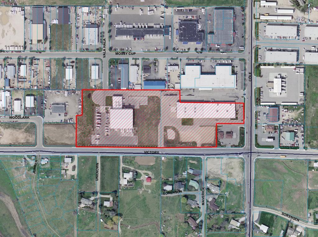
1 Subdivision Staff Report Subdivision Name Frito-Lay Park Subdivision File Number SUB Approval Preliminary/Final Plat Lead Agency Boise City Annexation Date Pending (CAR ) Comp. Plan Complies Public Hearing Date April 15, 2008 Heard by Boise City Council Planning and Zoning Commission Approval March 3, 2008 Staff Todd Tucker Description: This is a proposed industrial subdivision with four buildable lots acres. The subject property is currently improved with two industrial structures. The existing structures will remain. One structure will be located on the proposed Lot 1 and the other structure will remain in the proposed Lot 2. The subject property is currently located in the county and zoned M-3. There is an associated Annexation and Rezone Application (CAR ) to M-1D. Location: The site is located on the west side of S. Cole Road between W. Victory Road and W. Mossy Cup Street at the southern terminus of S. Vala Hala Avenue. Traffic Analysis: This development is estimated to generate approximately 150 additional vehicle trips per day, ITE Code 710 (General Office use) on lots 3 and 4 with a 20% floor-area-ratio at build-out. The existing uses generate approximately 430 vehicle trips per day, based on ITE Code 150 (Warehousing) for 86,000 square feet of warehouse and distribution facilities. Roadway Frontage Functional Classification Traffic Count Level of Service* Speed Limit Cole 210 Principal Arterial 21,436 north of Victory C 35 MPH 1/25/07 Victory 1,100 Minor Arterial 22,316 east of Maple Grove C 40 MPH 7/12/07 Vala Hala Stub Local Commercial No Data N/A 25 MPH *Acceptable level of service for a 4-lane principal arterial roadway is E (28,000 VTD). *Acceptable level of service for a 4-lane minor arterial roadway is D (25,000 VTD). Contents: Basis for Recommendation Vicinity Map
2 Preliminary Plat Final Plat Aerial Map Recommended Conditions of Approval Technical Review and Agency Comments Page 2 of 22
3 Page 3 of 22 Basis for Recommendation The Boise City Planning and Zoning Commission recommended approval of the Preliminary/Final Plat of the Frito-Lay Park Subdivision on March 3, On March 3, 2008 the Boise City Planning and Zoning Commission recommended approval of the proposed annexation and rezone to M-1D (CAR ). The Boise City Council public hearing for CAR is scheduled for April 15, The plat design and layout is in conformance with the Boise City Comprehensive Plan and complies with the basic requirements of the Boise City Subdivision and Zoning Ordinances. Staff is recommending the following special condition of approval: Condition 1 Condition 2 Condition 3 Prior to signature of the Final Plat by the City Engineer, the subject property shall be annexed and rezoned to M-1D in compliance with all the conditions of approval for CAR This condition requires compliance with all requirements of the Boise Airport. This condition addresses on-street parking as per the International Fire Code. Staff Perspective General The recommended conditions of approval are required to bring the proposed Preliminary/Final Plat into compliance with Boise City and Idaho State Codes and have been confirmed by the Boise City Planning and Development Services Department. Staff has reviewed the agency comments and Staff recommends approval based upon Staff's finding that all concerns of the commenting agencies have been addressed or are conditioned with the approval. To avoid potential problems the developer is directed to review the concerns identified in the technical reviews to verify that this statement is correct. Street Connectivity: The subject property is bordered on the south and east by existing public streets. South Vala Hala Avenue is stubbed into the subject property from the north. However, due to the current development on the property there is no opportunity to extend S. Vala Hala Avenue through the development to W. Victory Road. In addition, the applicant is not proposing to dedicate any new rights-of-way. Sidewalks: West Victory Road and S. Cole Road are both currently improved with five foot wide attached sidewalks as they abut the subject property. The applicant is not proposing any changes to the existing sidewalks. None known. Conditions in Dispute

4


5 PRELIMINARY PLAT OF FRITO-LAY PARK SUBDIVISION A Pcunm OF THE Y 1/4. ZE 1/4. secnw 24. T.3N. RIE.. B.U UJA COUNTY, IDAHO nqm I. ALL STORll ORAWGE TO BE RETANED ON SITE. 2. STREET I#PROVEAENTS TO BE BUbT TO A.C.HD. STAWARDS. JAN Plannln Dept. ~ubdi\sjslonp.,-.. $.

> FEET ADJACENT TO AH* STREET THIT 6 DEtUATEO TO T K USE OF TM RaUC THIS EASEAEHT SHALL NOT FUECLUT THE 8 SET MASS CAP CWSTRUCTON OF")

6 ;~I~' :b: NOTES I. WbG SETBACKS SHILL BE N ACCOWWCE W M TIC Za(m ORWNCS LEGEND AT THE TIAE OF 6SlUKE Cf TI BUPm ERAIT BUNDARY US 2. ANY RESU~DMSW OF TMS PUT ~H*U ZONHS REUTDNS H EFFECT AT T K TUE OF Rk3lSDNI+KIN. a. NID~~IKR vu corn~ rn TK nsaaaa~ a~mu\urrs a SECTKIN 3k3805 OF T K DM0 CWE. CPFWR TO n~ ~PRKABLE EASEAENT MKMARY PLAT OF ENTER LlhE ORIGNAL LOT L N 4. UL UTS bxs WEBY DESUUTED AS HImG A PEIIAAW RBUe UTUTES. LOT LNE D(UHACC. lr91c*lk% Am BOISE CJlY SlREET L M EISEZlKNT OVER 1% KN (I)> FEET ADJACENT TO AH* STREET THIT 6 DEtUATEO TO T K USE OF TM RaUC THIS EASEAEHT SHALL NOT FUECLUT THE 8 SET MASS CAP CWSTRUCTON OF HASD-SMFACW PIWEWAYS UO WALKWAYS TO CAM LOT. 6l F W A L W CAP id%' & % FRITO-LAY PARK SUBDIVISION A PORTION OF THE SE 1/4, SE 1/4, SECTION 24, T.3N., R.lE., B.M. BOISE, ADA COUNTY, IDAHO ~~ir",?%d&",!","w"on FbNC 518. RON PN W/ PLS EAM COAAON NERlOR LOT LINE. SET 5/llm X 30' RON PH./CAP ALL LOTS *amthc 1% EX- acue*ry OF n~ SU~DIVISION LRE 0 KREBY DEWATED AS HAYHC A PERRAW PUQUC m N FOUND V2' RON PN I! : 4 DR~ICE.. AND RRICATKIN U S E W OM9 THE TEN 110) FEET A D J ~ ' T o THE SU1 SET ~ 2 x. 24. RON PN./CAP -. " SCALE IN FEET EXTERM BOUNOARY. 1' - 100' 7. LOT 2. WHERE rf A M S SOUTH COLE ROAD 6 HEREBY mtp, *S 0 CALCULATED PW. NOT SET MAW A 35' SETBACK... ; " frg~,,e~i A",~k~&~T~T~oNYD~P;,"~~LUWtE.. WS1UTICU. EVDENCE OF A AWYUA NMSC LEVEL RmUCMH ff 24 C0 SHILL BE FUOVlDfD TO TW BULDlNC DlVlPOli OF T K PD5 DEPkRTW BY THE BLLDER PRIOR TO ISSUANCE OF A BJLDHC FCQMIT. AVICATDN V4 CPRKR EASEAEKT RECORDED WITH INSTRUnLKT N3 - CPbF #O4K) OTHER TH*N 1% ACCESS POHT SPECIFICUY m o v w a* TK HWAI MSTRKT AhD BMY CTf. WECT LOT A C E S TO C U ROAD ug KTDaY ROAD IS FUOHISITED. 10. RRlMTlON WATER W BEEN PROVED FROA IEV YPIK UHIL T(RICATDH WSTRKT. W COUtUNCE WTH DAHO CODf LOTS Y r m W M SWBWISW URL BE EHTmEO TO RRIUTDN IAlER RIMTS. UIO YLL BE l.i OBUGATEO FOIL ASSESS11ENTS FRO* MI YORK CAW PRGATION LWTIICT. > 4 < '.'AL.A t<fi.l.a. J V A L..A k!.4 L. A!!.!E>l>STf?!.b.!. f>.b.!?+: >!O. :? li4lllj$iti?lal. F'Ai?i:!<<I, 1 i3l.oi:e ti $i<)otti COL.iC C?iJSIP!Er5iS F'.b,F?+: PIC), 1... vr.~.k t4al.a lbiijli5;tf<lai- i:af?i: i*ic>. :4 i = l 1.0T 31. g!?!.<>c:b:!5 a 8 & N 90.M.M' Y a5 00' LOT I LOT 2 ui / I!.CjT 35 I/4 CORtiER CPLF S ~19'46.30~~ ZMICI' -- CPIF SW51B5957 I TEALEY'S LAND SURVEYING In7 EAST 30th SPET - c m am, ID. Bm4 2w-383-WJB a? - ~ m-~s-m ~!, s q2 4. Prorct No Shoat 1 of 2
7
8 Page 4 of 22 Recommended Conditions of Approval Special Conditions and Plat Notes 1. Prior to signature of the Final Plat by the Boise City Engineer, the property shall be annexed and rezoned to M-1D in compliance with all the conditions of approval for CAR Prior to the signature of the Boise City Engineer, the applicant/owner shall submit a recorded copy of an Avigation Easement over the entire platted area approved by the Boise City Airport Director. The face of the Final Plat shall show that the subdivision is subject to an avigation easement or easements (B.C.C F). 3. For streets having a width less than 36 feet back of curb to back of curb parking shall be restricted on (1) one side; for streets having a width less than 29 feet back of curb to back of curb parking shall be restricted on both sides; and for standard ACHD cul-de-sacs parking shall be restricted on both sides. A note on the face of the Final Plat is required noting the parking restriction prior to signing of the Final Plat by the Boise City Engineer. Covenant Requirements 4. Covenants, homeowners association by-laws or other similar deed restrictions acceptable to the Boise City Attorney, which provide for the use, control and maintenance of all common areas, storage facilities, access easements or open spaces shall be reviewed and approved by the Boise City Attorney. Erosion Control Requirements 5. Prior to the Boise City Engineer s Certification of the Final Plat and prior to earth disturbing activities, an erosion and sediment control (ESC) permit must be obtained. An ESC plan conforming to the requirements B.C.C. Title 8 Chapter 17, is to be submitted to the Director of Planning and Development Services for review and approval. No grading or earth disturbing activities may start until an approved ESC permit has been issued. 6. An individual who has attended the Boise City Responsible Person (RP) certification class, or has obtained Interim Certification for Responsible Person is not identified for this project. A permit will not issue until such time as the name and certification number of the RP has been provided to Boise City. This information can be faxed to or ed to swebb@cityofboise.org. Drainage Conditions 7. Subdivision drainage shall be in accordance to B.C.C E. The developer shall provide written approval from the appropriate drainage entity approving the drainage system, and/or acceptance of the subdivision drainage discharge; or submit a letter from a registered professional engineer certifying that all drainage shall be retained on-site. A copy of the
9 Page 5 of 22 approved construction drawing(s) depicting all site drainage improvements shall be submitted with the letter. A. Developer may either construct improvement prior to Final Platting or post bond in the amount of 110% of the estimated construction costs. Estimated construction costs shall be provided by the developer's engineer. B. For drainage facilities located outside of the public right-of-way, the developer shall dedicate a storm drainage easement. Said easement shall be labeled as either an Ada County Highway District storm drainage easement or a homeowners association storm drainage easement, depending on what entity will assume responsibility for the operation and maintenance of the storm drainage system. C. Should the homeowners association be responsible for the operation and maintenance of the storm drainage facilities, covenants, homeowners association by-laws or other similar deed restrictions acceptable to the Boise City Attorney shall be reviewed and approved by the Boise City Attorney. Irrigation Conditions 8. Comply with Boise City Code Section J concerning pressure irrigation requirements prior to signing of the Final Plat by the Boise City Engineer. A. The owner, person, firm or corporation filing the subdivision plat shall provide a pressurized irrigation system. The system must conform to the minimum design standards and specifications of Boise City, or of the entity that will operate and maintain the system, if that entity has published standards; or B. The owner, person, firm or corporation filing the subdivision plat shall provide written documentation that a valid waiver of the requirement to provide a pressure irrigation system and that Idaho Code (1)(a) regarding transfer of water rights, has been complied with. 9. Prior to either commencing construction or signing of the Final Plat by the Boise City Engineer, developer shall: A. Submit for approval by the Department of Public Works, construction plans and specifications for the pressurized system, stamped by a registered engineer. B. Provide written assurance that provisions have been made for ownership, operation, and maintenance of the system. C. Delineate all necessary irrigation easements on the Final Plat (B.C.C F).
10 Page 6 of Developer shall provide for an independent inspection of the installation of irrigation facilities and written certification by the design or project engineer that the system was installed according to the approved plans. In addition, the Department of Public Works must be present for the system pressure test and participate in a final inspection. 11. Developer may construct prior to final platting or bond in the amount of 110% of the estimated construction costs based on the approved plans. FEES: Developer and/or owner shall pay the current inspection and plan revuew fees applicable to the proposed subdivision prior to signing of the Final Plat by the Boise City Engineer (B.C.C ). 12. No ditch, pipe or structure for irrigation water or irrigation waste water shall be obstructed, rerouted, covered or changed in any way unless such obstruction, rerouting, covering or changing has first been approved by a signed and recorded License Agreement. A. Prior to signing of the Final Plat by the Boise City Engineer a recorded License Agreement for the relocation or alteration of any ditch, pipe or structure for irrigation water or irrigation waste water shall be provided to Boise City. The License Agreement shall be signed by the irrigation district, the water users and the applicant and shall contain a legal description and survey of the easement for the relocation of the irrigation facility. The recording number of the License Agreement shall be referenced in a note on the Final Plat and the easement shall be shown on the Final Plat. 13. Fence, cover or tile all irrigation ditches, laterals or canals and drains, exclusive of natural waterways, intersecting, crossing or lying adjacent to the subdivision prior to Final Platting or post bond in the amount of 110% of the estimated improvement cost with the Boise City Planning and Development Services Department. "Adjacent" is defined by the Boise City Code as "located within less than sixty feet (60') of any lot included in the development." A. Any covering or fencing program involving the distribution of any irrigation district shall have the prior approval of the affected district. B. If the developer requests a water amenity, such request shall comply with B.C.C F.5. C. Fencing shall be installed within 90 days of the issuance of the first building permit in the development, if building permits are obtained prior to completion of fencing improvements. Sewer Conditions 14. Wetline sewers are required (Boise City Code D, Improvements; Sanitary Sewers).
11 Page 7 of 22 A. Plans shall be submitted to and approved by the Boise City Department of Public Works prior to commencing with construction. Developer and/or owner may either construct improvements prior to Final Platting or execute a performance agreement and provide surety in the amount of 110% of the estimated costs. The developer and/or owner shall coordinate with the Department of Public Works for construction inspection prior to and during construction. Unless otherwise approved by the Public Works Department, all sewer construction shall be completed and accepted within 90 days of plat recordation, or within 30 days of issuance of the first building permit within the subdivision, whichever comes first. B. Developer and/or owner shall pay the current sewer inspection fees for the proposed subdivision prior to signing of the Final Plat by the Boise City Engineer. C. Developer and/or owner shall be responsible for repairs of any failures that occur within one (1) year of the project acceptance by the appropriate sewer entity (Boise City Code D.3, Improvements; Sanitary Sewers). 15. Developer and/or owner shall delineate all necessary Boise City sanitary sewer easements on the Final Plat prior to signing of the Final Plat by the Boise City Engineer (Boise City Code F, Design Standards; Easements). 16. Unless previously paid, developer and/or owner shall pay a sewer assessment along South Cole Road and West Victory Road and/or as may be approved by the Boise City Public Works Commission prior to signing of the Final Plat by the Boise City Engineer. Contact the Department of Public Works for specific costs. 17. Unless previously paid, developer and/or owner shall pay a connection fee and physically connect to sewer the existing building on Lot(s) 1 and 2, Block 1 prior to signing of the Final Plat by the Boise City Engineer or post bond/agreement for 110% of the cost to connect. 18. Developer and/or owner shall comply with all provisions of the Boise City Sewer Tap Ordinances. A. Developer and/or owner may either construct prior to Final Platting or post bond/agreement in the amount of 110% of the estimated costs. Please contact the Public Works Department for specifications and inspections during construction. NOTE: All bonding shall conform to Boise City Code B.3, Improvements; Filing of Plans and Surety, which specifies that the improvements to be made shall be done in a time period not to exceed one year from the date of approval of the Final Plat. Street Light Conditions 19. Developer shall delineate on the face of the Final Plat a Boise City street light easement, acceptable to the Boise City Department of Public Works, for the purpose of installing and
12 Page 8 of 22 maintaining city-owned street light fixtures, conduit, and wiring lying outside the dedicated public right-of-way (B.C.C F). 20. The developer shall be required to install, at their expense, street lights in accordance with Boise City Public Works specifications and standards at locations designated by the Public Works Department (B.C.C H). Plans shall be reviewed and approved by the Boise City Public Works Department prior to commencement of construction or bonding. FEES: Developer shall pay the current street light inspection and plan review fees on the proposed condominium (B.C.C ). 21. The street lights shall be installed and accepted by the Boise City Public Works Department at the following locations. Unless otherwise noted, street lights shall be installed at a 30-foot minimum mounting height, 250/400 W.H.P.S. A. Light Locations: Northwest Corner of Lot 11, Block 1 Northwest Corner of Lot 7, Block 1 Northwest Corner of Lot 3, Block 1 150ft. north of the Southwest Corner of Lot 3, Block 1 Southwest Corner of Lot 1, Block 1-30ft. minimum mounting height, 205/400 W.H.P.S. 22. If approval for bonding is granted by the Boise City Public Works Department, developer may bond in the amount of 110% of the estimated street light costs. Street lights shall be installed within 90 days of the issuance of the first building permit in the development, if building permits are obtained prior to completion of street light improvements. General Conditions 23. No Building Permit for the construction of any new structures shall be accepted until the Final Plat has been recorded pursuant to the requirements of the Boise City Subdivision Ordinance, Section A Compliance with all requirements of the Intermountain Gas Company is required. 25. The developer shall make arrangements to comply with all requirements of the Boise City Fire Department and verify in one of the following ways: A. A letter from the Boise City Fire Department stating that all conditions for water, access, and/or other requirements have been satisfied, OR
13 Page 9 of 22 B. A non-build agreement has been executed and recorded with a note on the face of the Final Plat identifying the instrument number. NOTE: "No Parking" signs and curb painting shall be required on streets having a width less than 36-feet, back of curb to back of curb. Contact the Boise City Fire Department for sign placement and spacing. Developer may either construct prior to Final Platting or post bond in the amount of 110% of the estimated costs with the Boise City Planning and Development Services Department. 26. The name, Frito-Lay Park Subdivision, is reserved and shall not be changed unless there is a change in ownership, at which time, the new owner(s) shall submit their new name to the Ada County Surveyor for review and reservation. Should a change in name occur, applicant shall submit, in writing, from the Ada County Surveyor, the new name to the Department of Planning and Development Services and reapproval by the Council of the "revised" Final Plat shall be required. Developer and/or owner shall submit all items including fees, as required by the Planning and Development Services Department, prior to scheduling the "revised" Final Plat for hearing. 27. Correct street names as approved by the Ada County Street Name Committee shall be placed on the plat (I.C. Title 50, Chapter 13). 28. A letter from the appropriate school district is required stating, "The Developer has made arrangements to comply with all requirements of the School District." 29. A letter of acceptance for water service from the utility providing same is required (B.C.C C). 30. Developer shall provide utility easements as required by the public utility providing service (B.C.C F). 31. Developer shall provide a letter from the United States Postal Service stating, "The Developer and/or Owner has received approval for location of mailboxes by the United States Postal Service." Contact: Dan Frasier, Postmaster 770 S. 13th St. Boise, ID Phone No. (208) FAX No. (208) Approval of sewer and water facilities by the Central District Health Department is required (I.C. Title 50, Chapter 13).
14 Page 10 of Developer shall comply with all construction standards of Ada County Highway District including approval of the drainage plan, requirements for installing curb, gutter, sidewalks and paving throughout the subdivision as specified by the Boise City Council. Signature by the Ada County Highway District on the plat is required (I.C. Title 50, Chapter 13). 34. Prior to submitting the Final Plat for recording, the following endorsements or certifications must be executed: Signatures of owners or dedicators, Certificate of the Surveyor, Certificate of the Ada County Surveyor, Certificate of the Central District Health Department, Certificate of the Boise City Engineer, Certificate of the Boise City Clerk, signatures of the Commissioners of the Ada County Highway District and the Ada County Treasurer (I.C. Title 50, Chapter 13). 35. Developer shall comply with B.C.C D.2 which specifies the limitation on time for filing and obtaining certification. Certification by the Boise City Engineer shall be made within two years from date of approval of the Final Plat by the Boise City Council. A. The developer may submit a request for a time extension, including the appropriate fee, to the Boise City Planning and Development Services Department for processing. Boise City Council may grant time extensions for a period not to exceed one year provided the request is filed, in writing, at least ten working days prior to the expiration of the first two year period, or expiration date established thereafter. B. If a time extension is granted, the Boise City Council reserves the right to modify and/or add condition(s) to the original preliminary or Final Plat to conform with adopted policies and/or ordinance changes. C. The plat shall be recorded with the Ada County Recorder within one year from the date of the Boise City Engineer s signature. If the Final Plat is not recorded within the one-year time frame it shall be deemed null and void. 36. The Frito-Lay Park Subdivision is approved for four buildable lots.
15 Page 11 of 22 Technical Review and Agency Comments Boise City Planning and Development Services Subdivision Section Todd Tucker Staff has reviewed the Preliminary/Final Plat and found that all proposed lots conform to the minimum dimensional standards of the Boise City Zoning Ordinance in the proposed M-1D Zoning District. Comprehensive Planning and Zoning Section Susan Riggs Boise City Comprehensive Plan This project is located in the Southwest Planning Area of the Boise City Comprehensive Plan. The following goals, objectives and policies for this planning area apply to this application. Chapter 8 LAND USE Objective 8.13 Landuse and development policies specific to the Southwest shall include the following: Policy The industrial area west of the airport shall be protected for light manufacturing uses. Retail and office uses may be permitted outside the approach zones and in compliance with the airport land use standards. Policy Office development on the east side of Maple Grove Road and Cole Roads shall be limited to light manufacturing and similar uses that are compatible with nearby residences and schools; trucking operations and other heavier industries shall be prohibited. Chapter 8, LAND USE Boise City Comprehensive Plan Goals, Objectives and Policies GOAL Achieve a city that minimizes suburban sprawl that provides for a diverse mixture of life-styles and atmospheres and a sense of place that varies throughout the different areas of the City, and that efficiently provides basic services and facilities in close proximity to where people live. Objective 1 The land-use map and attendant policies shall be the official guide for development of the planning area and shall be implemented through zoning and development review. 1) The Land Use/Zoning Consistency Matrix shall identify the zoning districts that are permissible within each land-use designation. Conformance with the Land Use/Zoning
16 Page 12 of 22 Consistency Matrix shall be a necessary finding of approval for all zone changes and conditional uses, unless one or more of the forms of flexibility identified in the policies under Objective 2 are implemented. 2) Zone change requests that are consistent with the Land Use/Zoning Consistency Matrix and the policies of the Comprehensive Plan should be approved by the City pursuant to appropriate findings related to service levels and other requirements of the comprehensive plan. (Excerpt From) Land Use / Zoning Consistency Matrix Land Use/Zoning Consistency Matrix 1) Land Use A U R-1A,B,C,M R-2 R-3 N-O L-O R-O C-1 C-2,3,4,5 PC H-S M-1 M-2 M-4 T-1 T-2 General Industrial X X X X X X X X X Table Definitions of Land Use Map Designations Page 3 of 3 Land Use Applies To Allowed Uses and/or Limitations Industrial Standard industrial land use. Heavy and light manufacturing, warehousing, mini-storage, open storage, multi-tenant industrial parks, automotive repair and similar uses are permitted. Limited office and commercial uses may be permitted as ancillary uses. Policy The Land Use/Zoning Consistency Matrix shall identify the zoning districts that are permissible within each land use designation. Conformance with the Land Use/Zoning Consistency Matrix shall be a necessary finding of approval for all zone changes and conditional uses, unless one or more of the forms of flexibility identified in the policies under Objective 2 are implemented. Policy Zone change requests that are consistent with the Land Use/Zoning Consistency Matrix and the policies of the Comprehensive Plan should be approved by the City pursuant to appropriate findings related to service levels and other requirements of the comprehensive plan.
17 Page 13 of 22 Chapter 10, GROWTH MANAGEMENT 10.0 Growth Management Goal Preserve, protect and enhance the overall quality of life in Boise and its Area of Impact by ensuring that growth occurs in an orderly manner and that public services are available along with development. Objective 1 Ensure that growth is planned and directed in a way that minimizes sprawl and creates a functional and pleasing community. Boise City Zoning Ordinance Section Purpose of Industrial District M-1 The M-1 District is established to provide for and encourage the grouping together of light industrial uses capable of being operated under such standards that they will be unobtrusive and will not be detrimental to surrounding commercial or residential uses. Areas set aside as M-1 may be classified as such in conformity with the Comprehensive Plan, and where it is found that in the public interest there is a need for industrial activities substantially free from residential or retail commercial activities with the subsequent finding that industrial uses are the highest and best use for the land involved. Building Section Marlene Southard
18 Page 14 of 22 No comment. Sediment and Erosion Control Steve Webb An erosion and sediment control plan (ESC) conforming to the requirements B.C.C. Title 8 Chapter 17 is to be submitted to the Director of Planning and Development Services for review. No grading or earth disturbing activities may start until approval of the ESC plan has been received and an ESC permit issued. An individual who has attended the Boise City Responsible Person (RP) certification class, or has obtained Interim Certification for Responsible Person is not identified for this project. A permit will not issue until such time as the name and certification number of the RP has been provided to Boise City. Boise City Public Works: Drainage/Engineering Rob Bousfield Standard drainage conditions. Pressure Irrigation Kent Johnson Standard irrigation conditions. Sewer John Johnson Standard sewer conditions. Street Lights Henry Alarcon Standard street light conditions. Boise City Fire Department Mark Senteno The Boise Fire Department has reviewed and can approve the application subject to compliance with the following code requirements and conditions of approval. Please note that unless stated otherwise this memo represents requirements of the International Fire Code as adopted and amended by Ordinance Specific Requirement: Fire Department vehicular access shall be provided to within 150' of all portions of the nonsprinklered buildings. Dead end roads are prohibited from exceeding 700 feet. These distances can be increased somewhat for sprinklered buildings but exact distances are on a case-by-case basis. All Fire Department access roads, fire lanes, bridges, and gates are to be a minimum of 20' wide with 13' 6" overhead clearance, shall be capable of supporting 70,000 lbs GVW (24,000 lbs per axle), and shall be paved. Fire Department access roads and fire lanes shall have a minimum outside turning radius of 48' with an inside radius of 28'. Any dead-end road in excess of 150' needs a Fire Department approved turnaround. No grade may exceed 10% (please note that fire apparatus are designed for a maximum 6% grade). Width and turning radius measurements specified by this paragraph can include those surfaces vehicles generally drive upon. Specifically, gutter and rolled curb are generally considered useable, while vertical curb or sidewalks are not.
19 Page 15 of 22 Condition of Approval: Provide vehicle access per code requirement. Code Requirement: For streets having a width less than 36 feet back of curb to back of curb parking shall be restricted on (1) one side; for streets having a width less than 29 feet back of curb to back of curb parking shall be restricted on both sides; and for standard ACHD cul-de-sacs parking shall be restricted on both sides. A note on the face of the Final Plat is required noting the parking restriction prior to signing of the Final Plat by the Boise City Engineer. In addition, No Parking signs shall be installed in accordance with the requirements of the IFC. Condition of Approval: Mark all fire lanes accordingly. Code Requirement: Maximum spacing for areas containing other than one & two family dwellings is 300 feet between hydrants. Comments: Two fire hydrants have been noted on submitted preliminary plat. In the absence of information on existing hydrants it appears that one or more new hydrants may/will be needed. However, we reserve the right to modify requirements as more information comes to light. Variables affecting hydrant numbers and location include, but are not limited to, area, construction type, existing hydrants, accuracy of information provided in the application, strategic location for fire fighting forces, and required fire flow. New hydrants must be "non-private" installations. Condition of Approval: Install new hydrants as required. General Requirement: Fire Department required fire hydrants, access, and street identification shall be installed prior to construction or storage of combustible materials on site. Provisions may be made for temporary access and identification measures. Note: Location of this project is within proposed Station 17 on the Master Siting Plan but is 2.3 miles from the closest current Boise Fire Department fire station. Specific building construction requirements of the International Building Code, International Fire Code, and Boise City Code will apply. However, these provisions are best addressed by a licensed Architect at building permit application. Intermountain Gas Company Michelle Singleton
20 Page 16 of 22 Intermountain Gas Company has received your letter of application. In order to best serve this development Intermountain Gas does require that a 5 minimum utility easement along the interior lot lines and a 10 minimum utility easement along all right of ways or private drive. The private drive of the development would also be required to include a utility easement for Intermountain Gas to encroach into with the gas lines. Boise Airport Matt Petaja Boise Airport staff has no objections to the project as proposed. This project is located within the Airport Influence Area B, which is affected by average sound levels in the DNL, and/or aircraft traffic patterns below 1,000 feet. Standard conditions of approval are contingent upon an avigation easement executed on the entire property. All new structures located within the overlay area are required to meet the sound attenuation standards of a minimum noise level reduction (NLR) of 30 DB in noise sensitive areas of the facility. Residential development is not allowed. The Airport also requires that within the airport influence area, all sign lighting and exterior lighting must be directed downward. No visible emissions that would interfere with aircraft operations are allowed. Ada County Highway District Matt Edmond A. Findings of Fact Existing Conditions 1. Site Information: The site currently contains a Frito-Lay distribution center and a Michaels of Oregon warehouse. 2. Description of Adjacent Surrounding Area: Direction Land Use Zoning North Industrial/business park (South Cole 1, Vala Hala 1) M-1 South Single-family residential, Commercial (Cornerpointe) RSW, R-6, L-O East Commercial (gas station, convenience store, realty) M-1D West Industrial park (Vala Hala 3) M-3 3. Existing Roadway Improvements and Right-of-Way Adjacent To and Near the Site Cole Road is currently improved with 5 lanes, vertical curb, gutter, and 5-foot attached concrete sidewalk, all inside 93-feet of right-of-way (45-feet from centerline) abutting the site. Victory Road is currently improved with 4 lanes, vertical curb, gutter, and 7-foot attached concrete sidewalk, all inside 66 to 80-feet of right-of-way (33 to 40-feet from centerline) abutting the site. Vala Hala Avenue is currently improved as a 40-foot commercial street section (back-of-curb to back-of-curb) with vertical curb, gutter, and no sidewalk where it stubs into the site.
21 Page 17 of 22 The intersection of Cole and Victory Roads is currently signalized with 5 lanes on all four approach legs. 4. Existing Access Cole Road: The site currently has one shared access point onto Cole Road approximately 175- feet north of the intersection with Victory Road (near-edge to near-edge), and an easement to use the South Cole Business Park access onto Cole Road, approximately 410-feet north of the intersection with Victory Road (near-edge to near-edge). Victory Road: The site currently has two access points onto Victory Road; one curb-cut approximately 350-feet and on curb-return access approximately 640-feet west of the intersection with Cole Road (near-edge to near-edge). Vala Hala Avenue currently stubs into the northwest portion of the site. 5. Site History: The ACHD Commission previously acted to approve a preliminary plat for Frito- Lay Park (00-05-PDI, CU) on April 5, The applicants did not get the Final Plat recorded, and are now applying for a revised plat in conjunction with annexation into Boise City. 6. Adjacent Development: There is no development occurring adjacent to the site. Development Impacts 7. Trip Generation: This development is estimated to generate approximately 150 additional vehicle trips per day, ITE Code 710 (General Office use) on lots 3 and 4 with a 20% floor-arearatio at build-out. The existing uses generate approximately 430 vehicle trips per day, based on ITE Code 150 (Warehousing) for 86,000sf of warehouse and distribution facilities. 8. Impact Fees: There will be an impact fee that is assessed and due prior to issuance of any building permits. The assessed impact fee will be based on the impact fee ordinance that is in effect at that time. 9. Traffic Impact Study: A traffic impact study was not required with this application. 10. Impacted Roadways: Roadway Frontage Functional Classification Principal Arterial Traffic Count Level of Service* Speed Limit Cole Road ,436 north of Victory 1/25/2007 C 35 MPH Victory Road 1100 Minor Arterial 22,316 east of Maple Grove 7/12/2007 C 40 MPH Vala Hala Local stub Avenue Commercial No data N/A 25 MPH *Acceptable level of service for 4-lane principal arterial roadways is E (28,000 VTD). *Acceptable level of service for 4-lane minor arterial roadways is D (25,000 VTD). 11. Capital Improvements Plan (CIP)/Five Year Work Plan (5YWP)
22 Page 18 of 22 Victory Road is currently scheduled in the CIP to be widened to 5 lanes between Maple Grove and Cole Roads in 11 to 20 years. B. Findings for Consideration 1. Cole Road Access & Offsets: District policy states that direct access to arterials and collectors is normally restricted. The developer shall try to use combined access points. If the developer can show that the use of a combined access point to a collector or arterial street is impractical, the District may consider direct access points. Access points for proposed developments at intersections should be located as far from the intersection as practical, and in no case closer than as illustrated on Figure 72-F4, unless a waiver for the access point has been approved by the District Commission. Applicant Proposal: The applicant has proposed to maintain the existing access point onto Cole Road (175-feet north of the Victory intersection). Staff Recommendation: Although the south access point onto Cole Road does not meet District policy 72-F4, staff recommends a modification of policy to allow it because it is an existing shared access point with the property to the south. The District reserves the right to close or restrict this driveway to right-in/right-out operations in the future as warranted by increased traffic volumes or other safety considerations. No additional right-of-way is required along Cole Road, as it is already fully improved as a 5 lane arterial section abutting the site. 2. Victory Road Right-of-Way: District policy requires 96-feet of right-of-way on arterial roadways (Figure 72- F1B). This right-of-way allows for the construction of a 5-lane roadway with curb, gutter, 5- foot concrete detached sidewalks and bike lanes. Access & Offsets: District policy states that direct access to arterials and collectors is normally restricted. The developer shall try to use combined access points. If the developer can show that the use of a combined access point to a collector or arterial street is impractical, the District may consider direct access points. Access points for proposed developments at intersections should be located as far from the intersection as practical, and in no case closer than as illustrated on Figure 72-F4, unless a waiver for the access point has been approved by the District Commission. Applicant Proposal: The applicant has proposed to dedicate additional right-of-way along Victory Road to total 48-feet from centerline, and to maintain the two existing access points onto Victory Road (350-feet and 640-feet west of the Cole intersection, respectively). Staff Recommendation: Staff recommends that the applicant close the eastern access point onto Victory Road and replace the curb cut with standard curb, gutter, and sidewalk, because it does not meet District policy 72-F4. Closure of this access point was a site specific requirement of the previous preliminary plat approval. Additionally, although deeds for the additional rightof-way along Victory Road may have been drawn up during the previous application process,
23 Page 19 of 22 they were not formally recorded. The applicant should dedicate additional right-of-way to total 48-feet from centerline to accommodate future widening of Victory Road. 3. Vala Hala Avenue Applicant Proposal: The applicant has proposed to maintain Vala Hala Avenue in its current condition, as a stub street with a turnaround easement on the site. The easement was recorded in 2001 and remains in effect. Staff Recommendation: Staff recommends approval of the applicant s proposal. 4. Other Access Applicant Proposal: The applicant is proposing cross access easements along the north side of lots 1 and 2, and between lots 1 and 4. Staff Recommendation: The applicant should provide cross access easements sufficient to afford all lots access to the approved access points both on Cole and Victory Roads. Cole and Victory Roads are classified as principal and minor arterials, respectively. Other than access specifically addressed in this application, direct lot access to these roads is prohibited and should be noted on the Final Plat. 5. Tree Planters Tree Planter Policy: The District s Tree Planter Width Interim Policy prohibits all trees in planters less than 8-feet in width. The policy also requires Class I and Class III trees to provide a minimum planter width of 10-feet. C. Site Specific Conditions of Approval 1. Dedicate additional right-of-way (approximately 8 to 15-feet) along Victory Road abutting the parcel to attain a total of 48-feet of right-of-way from the centerline. The right-of-way purchase and sale agreement and deed must be completed and signed by the applicant prior to scheduling the Final Plat for signature by the ACHD Commission or prior to issuance of a building permit (or other required permits), whichever occurs first. Allow up to 30 business days to process the right-of-way dedication after receipt of all requested material. The District will purchase the right-of-way which is in addition to existing right-of-way from available Corridor Preservation Funds. 2. Close the curb-cut access onto Victory Road located approximately 350-feet west of the Cole Road intersection, and replace the curb-cut with standard curb, gutter, and sidewalk. 3. Provide cross-access easements sufficient to afford all lots access to the approved access points on both Cole and Victory Roads. These easements shall be noted on the Final Plat. 4. Other than the shared access point approved with this application, direct lot access to Cole Road is prohibited and shall be noted on the Final Plat. 5. Other than the access point approved with this application, direct lot access to Victory Road is prohibited and shall be noted on the Final Plat. 6. Comply with all Standard Conditions of Approval.
24 Page 20 of 22 D. Standard Conditions of Approval 1. Any existing irrigation facilities shall be relocated outside of the right-of-way. 2. Private sewer or water systems are prohibited from being located within any ACHD roadway or right-of-way. 3. All utility relocation costs associated with improving street frontages abutting the site shall be borne by the developer. 4. Replace any existing damaged curb, gutter and sidewalk and any that may be damaged during the construction of the proposed development. Contact Construction Services at (with file number) for details. 5. Comply with the District s Tree Planter Width Interim Policy. 6. Utility street cuts in pavement less than five years old are not allowed unless approved in writing by the District. Contact the District s Utility Coordinator at (with file numbers) for details. 7. All design and construction shall be in accordance with the Ada County Highway District Policy Manual, ISPWC Standards and approved supplements, Construction Services procedures and all applicable ACHD Ordinances unless specifically waived herein. An engineer registered in the State of Idaho shall prepare and certify all improvement plans. 8. The applicant shall submit revised plans for staff approval, prior to issuance of building permit (or other required permits), which incorporates any required design changes. 9. Construction, use and property development shall be in conformance with all applicable requirements of the Ada County Highway District prior to District approval for occupancy. 10. Payment of applicable road impact fees is required prior to building construction. The assessed impact fee will be based on the impact fee ordinance that is in effect at that time. 11. It is the responsibility of the applicant to verify all existing utilities within the right-of-way. The applicant at no cost to ACHD shall repair existing utilities damaged by the applicant. The applicant shall be required to call DIGLINE ( ) at least two full business days prior to breaking ground within ACHD right-of-way. The applicant shall contact ACHD Traffic Operations in the event any ACHD conduits (spare or filled) are compromised during any phase of construction. 12. No change in the terms and conditions of this approval shall be valid unless they are in writing and signed by the applicant or the applicant s authorized representative and an authorized representative of the Ada County Highway District. The burden shall be upon the applicant to obtain written confirmation of any change from the Ada County Highway District. 13. Any change by the applicant in the planned use of the property which is the subject of this application, shall require the applicant to comply with all rules, regulations, ordinances, plans, or other regulatory and legal restrictions in force at the time the applicant or its successors in interest advises the Highway District of its intent to change the planned use of the subject property unless a waiver/variance of said requirements or other legal relief is granted pursuant to the law in effect at the time the change in use is sought. E. Conclusions of Law 1. The proposed site plan is approved, if all of the Site Specific and Standard Conditions of Approval are satisfied.
25 Page 21 of ACHD requirements are intended to assure that the proposed use/development will not place an undue burden on the existing vehicular transportation system within the vicinity impacted by the proposed development. Ada County Street Name Committee The following existing street names shall appear on the plat: S. Cole Road S. Jupiter Avenue S. Vala Hala Avenue W. Victory Road Central District Health Department Malcohm McGregor After written approval from appropriate entities is submitted, we can approve this proposal for central sewage and central water. The following plans must be submitted to and approved by the Idaho Department of Health and Welfare, Division of Environmental Quality: A. Central Sewage B. Central Water Street runoff is not to create a mosquito breeding problem. Plans must be submitted for a plan review for any: A. Food establishment B. Beverage establishment STORMWATER MANAGEMENT RECOMMENDATIONS It is recommended that storm water be pre-treated prior to discharge to the subsurface to prevent impact to ground water and surface water quality. The engineers and architects involved with the design of this project should obtain current best management practices for stormwater disposal and design a stormwater management system that is preventing groundwater and surface water degradation. Manuals that could be used for guidance are: 1) Stormwater Best Management Practices Guidebook Prepared by the Boise City Public Works Department, May ) State of Idaho Catalog of Stormwateter Best Management Practices for Idaho Cities and Counties Prepared by the Idaho Division of Environmental Quality, July New York Irrigation District No comments received. Independent School District of Boise City #1 Sarah Strobaugh
26 Page 22 of 22 At the present time, the Developer and/or Owner have made arrangements to comply with all requirements of the Boise School District. The schools assigned to the proposed project area are: Elementary School: Maple Grove Junior High School: South currently West effective August 2008 High School: Borah United States Postal Service Dan Frasier, Postmaster The City of Boise and Ada County have agreed that no Final Plat maps will be approved without the following condition being met. Prior to the signing of the Final Plat by the City Engineer, the Developer and/or Owner shall provide an letter from the United States Postal Service stating, The Developer and/or Owner has received approval fro location of mailboxes by the United States Postal Service. Contact: Dan Frasier, Postmaster 770 S. 13 th Street. Boise, ID Phone: (208) Fax: (208) The following are the basic conditions requested by the Postal Service. 1. In all new residential areas, service will be provided to Cluster Box Units (CBU s). It will be the responsibility of the contractor to pour a cement pad meeting the required specifications in a location(s) approved by the Postal Service. 2. The clustering of all boxes in one approved area is recommended for multi-family dwellings, e.g., condos, duplexes, triplexes, etc. All locations must still be approved. 3. Infill development, defined as three or less residential lots, may receive the existing mode of delivery as the rest of the neighborhood. All locations must still be approved.
Subdivision Staff Report
 Subdivision Staff Report Subdivision Name Coldstream File Number SUB06-00040 Subdivision Approval Preliminary Plat Lead Agency Boise City Annexation Date December 9, 1974 Comp. Plan Complies Public Hearing
Let me know if I need to bring you any other documentation for this withdrawl. Thanks!
 >>> david benoit 11/27/2007 10:00 AM >>> Dave, I am set to be heard on the Cranston Corner Subdivision on December 4th in front of City council. I have sold this property and am requesting
Time Extension Staff Report
 Time Extension Staff Report Subdivision Name Lunara Subdivision File Number SUB07-00019 Approval Time Extension for Lead Agency Boise City Certification Signature of Boise City Engineer Annexation Date
Subdivision Staff Report
 Subdivision Staff Report Subdivision Name Honeymoon Cove Subdivision File Number SUB08-00005 Approval Preliminary/ Final Plat Lead Agency Boise City Annexation Date December 30, 2004 Comp. Plan Complies
Time Extension Staff Report
 Time Extension Staff Report Subdivision Name Therrin Subdivision File Number SUB06-00020 Approval Time Extension for Lead Agency Boise City Certification Signature of Boise City Engineer Annexation Date
Subdivision Staff Report
 Subdivision Staff Report Subdivision Name Madera Creek File Number SUB06-00068 Subdivision Approval Final Plat Lead Agency Boise City Annexation Date December 9, 1974 Comp. Plan Complies Public Hearing
Subdivision Staff Report
 Subdivision Staff Report Subdivision Name Toli Park Subdivision File Number SUB07-00035 Approval Preliminary Plat Lead Agency Boise City Annexation Date December 30, 1987 Comp. Plan Complies Public Hearing
Subdivision Staff Report
 Subdivision Staff Report Subdivision Name Birmingham Place File Number SUB06-00051 Subdivision Approval Preliminary/Final Plat Lead Agency Boise City Annexation Date December 3, 1962 Comp. Plan Complies
Location: The subject property is located at the northeast corner of S. Holden Lane and E. Boise Avenue.
 Subdivision Staff Report Subdivision Name Tianna Park File Number SUB11-00008 Approval Preliminary Plat Lead Agency Boise City Annexation Date December 19, 1977 Comp. Plan Complies Public Meeting Date
Subdivision Staff Report
 Subdivision Staff Report Subdivision Name Greenfield Park File Number SUB06-00110 Subdivision Approval Preliminary/Final Plat Lead Agency Boise City Annexation Date December 9, 1974 Comp. Plan Complies
Subdivision Staff Report
 Subdivision Staff Report Subdivision Name Athletic Subdivision File Number SUB08-00023 Approval Preliminary/ Final Plat Lead Agency Boise City Annexation Date July 30, 1984 Comp. Plan Complies Public Hearing
Subdivision Staff Report
 Subdivision Staff Report Name: Brownstone Subdivision Date: May 12, 2004 File: SUB04-00041 Meeting: May 18, 2004 Approval: Preliminary To: City Council Lead Agency: Ada County (04-10-S) From: Richard Beck
Subdivision Staff Report
 Subdivision Staff Report Subdivision Name Sunnyridge Subdivision File Number SUB07-00007 Approval Preliminary Plat Lead Agency Ada County Annexation Date NA Comp. Plan Complies (With Conditions of Approval)
Committed to Service
 Committed to Service Paul Woods, President Rebecca W. Arnold, Vice President Sara M. Baker, Commissioner Jim D. Hansen, Commissioner Kent Goldthorpe, Commissioner August 25, 2017 Development Services TO:
Hal Simmons Planning Director Boise City Planning and Development Services. CAR / 1689 South Entertainment Avenue
 MEMORANDUM MEMO TO: FROM: Mayor and Boise City Council Hal Simmons Planning Director Boise City Planning and Development Services DATE: November 15, 2008 RE: CAR08-00019 / 1689 South Entertainment Avenue
Right-of-Way & Development Services Planning Review Division Committed to Service This application is approved at the staff level on February 1, 2006.
 Right-of-Way & Development Services Planning Review Division Committed to Service This application is approved at the staff level on February 1, 2006. Tech Review for this item was held with the applicant
May 21, ACHD Board of Commissioners Stacey Yarrington, Planner II DRH /DRH
 Development Services Department May 21, 2013 TO: FROM: SUBJECT: ACHD Board of Commissioners Stacey Yarrington, Planner II DRH13-00106/DRH13-00108 Executive Summary: This is a design review application
Date: March 16, Jake Centers ERD, LLC P.O. Box 1610 Eagle, ID Elevation Ridge Subdivision (SUB & PUD ) Street Address
 Street Address") Rebecca W. Arnold, President Sara M. Baker, Vice President John S. Franden, Commissioner Carol A. McKee, Commissioner David L. Case, Commissioner Date: March 16, 2012 To: Jake Centers ERD, LLC P.O. Box
Rebecca W. Arnold, President Sara M. Baker, Vice President John S. Franden, Commissioner Carol A. McKee, Commissioner David L. Case, Commissioner Date: March 16, 2012 To: Jake Centers ERD, LLC P.O. Box
Amended Subdivision Staff Report
 Amended Subdivision Staff Report Subdivision Name Silverpine Subdivision File Number SUB06-00052 No.2 Approval Preliminary Plat Lead Agency Ada County Annexation Date NA Comp. Plan Complies (With Conditions
Subdivision Staff Report
 Subdivision Staff Report Subdivision Name Cayenne Corner File Number SUB06-00060 Subdivision Approval Final Plat Lead Agency Boise City Annexation Date January 1, 1987 Comp. Plan Complies Public Hearing
If you have any questions, please feel free to contact me at (208)
") Sara M. Baker, President John S. Franden, Vice President Rebecca W. Arnold, Commissioner Mitchell A. Jaurena, Commissioner Jim Hansen, Commissioner Date: March 21, 2013 To: Subject: Hornet Construction
Sara M. Baker, President John S. Franden, Vice President Rebecca W. Arnold, Commissioner Mitchell A. Jaurena, Commissioner Jim Hansen, Commissioner Date: March 21, 2013 To: Subject: Hornet Construction
Executive Summary: This is a preliminary plat to construct 8 residential lots and 2 commons lots with a private road on 3.87-acres in Meridian, Idaho.
 Development Services Department DATE: July 7, 2015 TO: FROM: SUBJECT: ACHD Board of Commissioners Stacey Yarrington, Planner III Kentucky Villas/ MPP15-0012/ PP15-009 Executive Summary: This is a preliminary
RE: CAR / 4280 N.
 MEMORANDUM TO: FROM: Mayor and Boise City Council Hal Simmons - Planning Director Boise City Planning and Development Services DATE: April 29, 2009 RE: CAR09-00006 / 4280 N. Eagle Road The following application
BOI / DRH Albertsons grocery market and fueling center & pad sites
 Paul Woods, President Rebecca W. Arnold, Vice President Sara M. Baker, Commissioner Jim D. Hansen, Commissioner Kent Goldthorpe, Commissioner March 28, 2017 To: Mark Palmer Albertsons Companies 250 E.
Committed to Service
 Committed to Service Sara M. Baker, President Rebecca W. Arnold, Vice President Jim D. Hansen, Commissioner Kent Goldthorpe, Commissioner Paul Woods, Commissioner January 16, 2018 Development Services
3. The preliminary plats were approved on March 27, 2014 and August 14, 2014.
 Jim D. Hansen, President Sara M. Baker, Vice President Rebecca W. Arnold, Commissioner Kent Goldthorpe, Commissioner Paul Woods, Commissioner February 12, 2015 Development Services Department To: From:
SUB /CAR /PUD
 Development Services Department Project/File: Lead Agency: Site address: Balntyre Court Subdivision/BPP16-0036/ SUB16-00066/CAR16-00035/PUD16-00040 This is a rezone, planned unit development, and subdivision
#1 (CAR /SUB )
") Development Services Department Project/File: Lead Agency: Site address: Fork South #1 (CAR14-00009/SUB14-00024) The applicant is requesting annexation, rezone and preliminary plat approvals for a 52-lot
Development Services Department Project/File: Lead Agency: Site address: Fork South #1 (CAR14-00009/SUB14-00024) The applicant is requesting annexation, rezone and preliminary plat approvals for a 52-lot
Committed to Service
 Committed to Service Kent Goldthorpe, President Paul Woods, Vice President Rebecca W. Arnold, Commissioner Sara M. Baker, Commissioner Jim D. Hansen, Commissioner July 18, 2016 Development Services TO:
Date: August 29, Dave Scaggs (sent via ) Summit Development Inc th Ave. Rd. #384 Nampa, ID 83686
 Summit Development Inc th Ave. Rd. #384 Nampa, ID 83686") Sara M. Baker, President John S. Franden, Vice President Rebecca W. Arnold, Commissioner Mitchell A. Jaurena, Commissioner Jim Hansen, Commissioner Date: August 29, 2013 To: Dave Scaggs (sent via email)
Sara M. Baker, President John S. Franden, Vice President Rebecca W. Arnold, Commissioner Mitchell A. Jaurena, Commissioner Jim Hansen, Commissioner Date: August 29, 2013 To: Dave Scaggs (sent via email)
Subdivision Staff Report
 Subdivision Staff Report Name: Madronawood Subdivision Date: January 26, 2005 File: SUB05-00005 Meeting: February 1, 2005 Approval: Preliminary To: City Council Lead Agency: Ada County (04-31-S) From:
SUB / Diamante Subdivision / Northside Management
 SU15-00062 / Diamante Subdivision / Northside Management Summary: Subdivision application for a Preliminary Plat consisting of 20 buildable lots and 3 common lots. Prepared y: Todd Tucker, Senior Planner
Section Preliminary Plat Checklist and Application Forms
 Section 201 - Preliminary Plat Checklist and Application Forms PRELIMINARY SUBDIVISION PLAT REVIEW PROCESS CHART PRELIMINARY SUBDIVISION PLAT APPLICATION PRELIMINARY PLAT REVIEW CHECKLIST CITY OF NAMPA
DAUPHIN CREEK ESTATES SUBDIVISION
 # 12 SUB-000076-2017 DAUPHIN CREEK ESTATES SUBDIVISION Engineering Comments: FINAL PLAT COMMENTS (should be addressed prior to submitting the FINAL PLAT for review and/or signature by the City Engineer):
SECTION 7000 LAND DEVELOPMENT REQUIREMENTS
 SECTION 7000 LAND DEVELOPMENT REQUIREMENTS 7000 LAND DEVELOPMENT REQUIREMENTS... 1 7001 LEGISLATIVE AUTHORITY... 1 7001.1 LAND DEVELOPMENT... 1 7001.1.1 Title 40, Idaho Code... 1 7001.1.2 Idaho Code 40-1415
BYRON TOWNSHIP ZONING APPLICATION
 BYRON TOWNSHIP ZONING APPLICATION Phone: (616) 878-9104 * Fax: (616) 878-3980 * Website: www.byrontownship.org This application will not be accepted if incomplete. APPLICATION FOR & REQUIRED COPIES Private
a. provide for the continuation of collector streets and thoroughfare streets between adjacent subdivisions;
 Section 7.07. Intent The requirements of this Section are intended to provide for the orderly growth of the Town of Holly Springs and its extra-territorial jurisdiction by establishing guidelines for:
ZONING AMENDMENT, PLANNED UNIT DEVELOPMENT & SUBDIVISION STAFF REPORT Date: August 8, 2013
 ZONING AMENDMENT, PLANNED UNIT DEVELOPMENT & SUBDIVISION STAFF REPORT Date: August 8, 2013 NAME SUBDIVISION NAME PV-Magnolia, LLC Twelve Trees Subdivision LOCATION 2860, 2862 and 2866 Pleasant Valley Road
PLANNED UNIT DEVELOPMENT & SUBDIVISION STAFF REPORT August 18, 2016
 PLANNED UNIT DEVELOPMENT & SUBDIVISION STAFF REPORT August 18, 2016 DEVELOPMENT NAME SUBDIVISION NAME Mullinax Ford Subdivision Mullinax Ford Subdivision LOCATION CITY COUNCIL DISTRICT District 6 Southeast
ARTICLE 23 CONDOMINIUM STANDARDS
 ARTICLE 23 CONDOMINIUM STANDARDS Section 23.01 Intent. The intent of this Article is to provide regulatory standards for condominiums and site condominiums similar to those required for projects developed
ZONING AMENDMENT & SUBDIVISION STAFF REPORT Date: July 9, 2015
 ZONING AMENDMENT & SUBDIVISION STAFF REPORT Date: July 9, 2015 APPLICANT NAME 2513 Dauphin Street, Inc. SUBDIVISION NAME Audubon Place Extension No. 3, Resubdivision of Lots 1-5 LOCATION 2513 Dauphin Street
SUBDIVISION, PLANNED UNIT DEVELOPMENT, ZONING AMENDMENT, & SIDEWALK WAIVER STAFF REPORT Date: July 19, 2018
 SUBDIVISION, PLANNED UNIT DEVELOPMENT, ZONING AMENDMENT, & SIDEWALK WAIVER STAFF REPORT Date: July 19, 2018 NAME SUBDIVISION NAME LOCATION West Mobile Properties, LLC U.S. Machine Subdivision 556, 566,
Subdivision Staff Report
 Subdivision Staff Report Subdivision Name Watertower Place File Number SUB08-00008 Subdivision Approval Preliminary/Final Plat Lead Agency Boise City Annexation Date December 31, 1965 Comp. Plan Complies
ARTICLE IV: DEVELOPMENT STANDARDS
 ARTICLE IV: DEVELOPMENT STANDARDS IV-53 409 PRIVATE STREETS A private street means any way that provides ingress to, or egress from, property by means of vehicles or other means, or that provides travel
-MENDOCINO COUNTY PLANNING AND BUILDING SERVICES- DIVISION OF LAND REGULATIONS TITLE 17
 ARTICLE VI -- GENERAL REGULATIONS AND PROVISIONS Sec. 17-50. Sec. 17-51 General Plan. Sec. 17-52 Lot and Block Design and Configuration. Sec. 17-53 Lot Access. Sec. 17-54 Private Roads. Sec. 17-55 Water
ZONING AMENDMENT & SUBDIVISION STAFF REPORT Date: November 3, 2016
 ZONING AMENDMENT & SUBDIVISION STAFF REPORT Date: November 3, 2016 APPLICANT NAME SUBDIVISION NAME David Shumer 5955 Airport Subdivision CITY COUNCIL DISTRICT District 6 5955 Airport Boulevard, 754 Linlen
COMMERCIAL SITE PLAN & CONDITIONAL USE PERMIT REVIEW PROCESS & CHECKLIST
 Community Development 110 South Main Street Springville, UT 84663 COMMERCIAL SITE PLAN & CONDITIONAL USE PERMIT REVIEW PROCESS & CHECKLIST 801.491.7861 www.springville.org Prior to the issuance of a building
INTEROFFICE MEMORANDUM
 INTEROFFICE MEMORANDUM DATE: February 3, 2009 TO: Public Works Commission FROM: Mike Sheppard, P.E, Civil Engineer SUBJECT: Appeal of Boise City Public Works Denial of Request for an Alternative Sewer
SUBDIVISION, PLANNING APPROVAL, & REZONING STAFF REPORT Date: June 4, 2015
 SUBDIVISION, PLANNING APPROVAL, & REZONING STAFF REPORT Date: June 4, 2015 APPLICANT NAME SUBDIVISION NAME DEVELOPMENT NAME LOCATION Board of Water & Sewer Commissioners of the City of Mobile MAWSS MLK
PLANNED UNIT DEVELOPMENT & SUBDIVISION STAFF REPORT Date: April 18, 2019
 PLANNED UNIT DEVELOPMENT & SUBDIVISION STAFF REPORT Date: April 18, 2019 DEVELOPMENT NAME SUBDIVISION NAME Springhill Village Subdivision Springhill Village Subdivision LOCATION 4350, 4354, 4356, 4358,
Committed to Service. License Agreement Application Form
 Committed to Service License Agreement Application Form PLEASE NOTE: Effective February 16, 2010 - License Agreements within the downtown Boise area for public structures, objects and uses on ACHD sidewalks
Committed to Service
 Development Services Department Committed to Service June 23, 2015 TO: FROM: SUBJECT: ACHD Board of Commissioners Mindy Wallace, AICP Planner III Linder Apartments - EAG15-0005/ CPA-01-15/A-01-15/RZ-04-15
ZONING AMENDMENT, PLANNED UNIT DEVELOPMENT & SUBDIVISION STAFF REPORT Date: September 15, 2011
 ZONING AMENDMENT, PLANNED UNIT DEVELOPMENT & SUBDIVISION STAFF REPORT Date: September 15, 2011 NAME SUBDIVISION NAME LOCATION Stratford, L.L.C. Grelot Office Park Subdivision North side of Grelot Road,
M-43 CORRIDOR OVERLAY ZONE
 ARTICLE 26.00 M-43 CORRIDOR OVERLAY ZONE Section 26.01 Findings A primary function of the M-43 state highway is to move traffic through the Township and to points beyond. As the primary east-west arterial
APPLICATION PROCEDURE
 ANTRIM PLANNING BOARD P. O. Box 517 Antrim, New Hampshire 03440 Phone: 603-588-6785 FAX: 603-588-2969 APPLICATION FORM AND CHECKLIST FOR MINOR OR MAJOR SITE PLAN REVIEW File Date Received By APPLICATION
DIVISION 2 - CONSTRUCTION PLAN AND MISCELLANEOUS REQUIREMENTS
 DIVISION 2 - CONSTRUCTION PLAN AND MISCELLANEOUS REQUIREMENTS 2.1 Required Plan Sheets 2.2 Drawing Requirements 2.3 Graphic Standards 2.4 Easements 2.5 Utility Locations 2.6 Private Facility Locations
TOWN OF LEWISTON PLANNING BOARD APPLICATION
 TOWN OF LEWISTON PLANNING BOARD APPLICATION DESCRIPTION OF PROPOSED REQUEST: Name of Property Owner: Phone #: Name of Applicant:Phone #: Address or Location of Proposal:_SBL# Size of Parcel or Structure:Existing
AAAA. Planning and Zoning Staff Report Lake Shore Land Holdings, LLC CU-PH Analysis
 AAAA Planning and Zoning Staff Report Lake Shore Land Holdings, LLC CU-PH2016-28 Hearing Date: April 21, 2016 Development Services Department Applicant: BRS Architects/Cindy Huebert Staff: Kyle McCormick,
WRITTEN DECISION OF THE HAYDEN CITY COUNCIL REGARDING MAPLE GROVE PRELIMINARY SUBDIVISION APPLICATION (SUB-0013) HAYDEN SIGNATURE, LLC
 HAYDEN SIGNATURE, LLC") WRITTEN DECISION OF THE HAYDEN CITY COUNCIL REGARDING MAPLE GROVE PRELIMINARY SUBDIVISION APPLICATION (SUB-0013) HAYDEN SIGNATURE, LLC Application of Hayden Signature, LLC, an Idaho limited liability company,
WRITTEN DECISION OF THE HAYDEN CITY COUNCIL REGARDING MAPLE GROVE PRELIMINARY SUBDIVISION APPLICATION (SUB-0013) HAYDEN SIGNATURE, LLC Application of Hayden Signature, LLC, an Idaho limited liability company,
ROAD APPROACH ORDINANCE #44 TILLAMOOK COUNTY OREGON. ADOPTED September 18, UPDATED June 23, UPDATED June 28, UPDATED July 24, 1996
 ROAD APPROACH ORDINANCE #44 TILLAMOOK COUNTY OREGON ADOPTED September 18, 1991 UPDATED June 23, 1993 UPDATED June 28, 1995 UPDATED July 24, 1996 UPDATED June 23, 1999 UPDATED January 1, 2009 UPDATED November
STAFF REPORT Administrative Subdivision Hearing West 150 South Street, Parcel # , and
 Petition Number: 490-06-24 STAFF REPORT Administrative Subdivision Hearing Project Name: Project Location: Project Type: Applicant: Planning Staff: Haight Industrial Subdivision 5550 West 150 South Street,
APPLICANT NAME SUBDIVISION NAME DEVELOPMENT NAME LOCATION. CITY COUNCIL DISTRICT Council District 4 PRESENT ZONING PROPOSED ZONING
 SUBDIVISION, PLANNED UNIT DEVELOPMENT, PLANNING APPROVAL, ZONING AMENDMENT, & SIDEWALK WAIVER REQUEST STAFF REPORT Date: February 17, 2010 APPLICANT NAME SUBDIVISION NAME DEVELOPMENT NAME LOCATION David
ALBA BEACH SUBDIVISION, RESUBDIVISION OF LOT 17
 ALBA BEACH SUBDIVISION, RESUBDIVISION OF LOT 17 Engineering Comments: FINAL PLAT COMMENTS (should be addressed prior to submitting the FINAL PLAT for acceptance and signature by the City Engineer): A.
CHAPTER 32 SUBDIVISIONS SECTION TITLE PAGE NO.
 Page 1 of 46 CHAPTER 32 SUBDIVISIONS SECTION TITLE PAGE NO. SECTION 32-1 Purpose of Ordinance 3 SECTION 32-2 Definitions 3 SECTION 32-3 Staff Sketch Review 4 SECTION 32-4 Subdivision and PUD Plats Required
ZONING AMENDMENT, SUBDIVISION & SIDEWALK WAIVER REQUEST STAFF REPORT Date: November 16, 2006
 ZONING AMENDMENT, SUBDIVISION & SIDEWALK WAIVER REQUEST STAFF REPORT Date: November 16, 2006 NAME SUBDIVISION NAME Terhaar & Cronley Investment Partnership P & E Subdivision LOCATION 4210 and 4218 Halls
HERON LANDING SUBDIVISION
 HERON LANDING SUBDIVISION Engineering Comments: Per FEMA guidelines, any development greater than 5 acres in size or subdivision 50 lots in size, requires a flood study. Width of drainage easement to be
DINKINS ESTATE FAMILY SUBDIVISION
 # 9 SUB2015-00122 DINKINS ESTATE FAMILY SUBDIVISION Engineering Comments: The following comments should be addressed prior to submitting the FINAL PLAT for acceptance and signature by the City Engineer:
Planning Director Boise City Planning and Development Services Department. RE: CAR / DA: Rezone & Development Agreement / 6401 S.
 MEMORANDUM TO: FROM: Mayor and Boise City Council Hal Simmons Planning Director Boise City Planning and Development Services Department DATE: May 22, 2006 RE: CAR06-00019/ DA: Rezone & Development Agreement
PLANNED UNIT DEVELOPMENT & SUBDIVISION STAFF REPORT Date: July 20, 2017
 PLANNED UNIT DEVELOPMENT & SUBDIVISION STAFF REPORT Date: July 20, 2017 DEVELOPMENT NAME SUBDIVISION NAME LOCATION Rangeline Crossing III Subdivision Rangeline Crossing III Subdivision 5289 Halls Mill
PLANNED UNIT DEVELOPMENT & SUBDIVISION STAFF REPORT Date: November 17, 2016
 PLANNED UNIT DEVELOPMENT & SUBDIVISION STAFF REPORT Date: November 17, 2016 DEVELOPMENT NAME SUBDIVISION NAME LOCATION Autonation Ford of Mobile Autonation Ford of Mobile Subdivision 901, 909, and 925
The following information is for use by the Lincoln County Planning Board at their meeting/public hearing on February 3, 2014.
 LINCOLN COUNTY PLANNING & INSPECTIONS DEPARTMENT 302 NORTH ACADEMY STREET, SUITE A, LINCOLNTON, NORTH CAROLINA 28092 704-736-8440 OFFICE 704-736-8434 INSPECTION REQUEST LINE 704-732-9010 FAX To: Planning
MAJOR ISSUES DISCUSSED To date, there has been no opposition to this request and no member of the public has testified. ***
 CAR07-00051 Page 2 SUMMARY Larry and Barbara Woolf request approval to rezone ± 1.33 acres from R-1C (Single Family Residential with a maximum of 8.0 DU/acre) to R-2D (Combined Residential with a maximum
Appendix A. Definitions
 Definitions 1. Terms Defined. Words contained in this are those having a special meaning relative to the purposes of this Ordinance. Words not listed in this section shall be defined by reference to: (1)
WESTMINSTER PARK SUBDIVISION
 WESTMINSTER PARK SUBDIVISION Engineering Comments: FINAL PLAT COMMENTS (should be addressed prior to submitting the FINAL PLAT for review and/or signature by the City Engineer): A. Provide all of the required
Condominium Unit Requirements.
 ARTICLE 19 CONDOMINIUM REGULATIONS Section 19.01 Purpose. The purpose of this Article is to regulate projects that divide real property under a contractual arrangement known as a condominium. New and conversion
610 LAND DIVISIONS AND PROPERTY LINE ADJUSTMENTS OUTSIDE A UGB
 ARTICLE VI: LAND DIVISIONS AND PROPERTY LINE ADJUSTMENTS VI-21 610 LAND DIVISIONS AND PROPERTY LINE ADJUSTMENTS OUTSIDE A UGB 610-1 Property Line Adjustments (Property Line Relocation) A property line
ORDINANCE NO. Be it ordained by the City Council of the City of Abilene, Texas:
 ORDINANCE NO. An ordinance repealing Chapter 23, Subpart B of the Code of the City of Abilene, Texas, entitled Mobile Homes and Vacation Travel Trailers; stating the authority; setting forth the scope
ZONING AMENDMENT & SUBDIVISION STAFF REPORT Date: June 18, 2015
 ZONING AMENDMENT & SUBDIVISION STAFF REPORT Date: June 18, 2015 APPLICANT NAME SUBDIVISION NAME EAA LLC / Eryka Rogers Aaiden Place Subdivision LOCATION 2480 Government Boulevard (North side of Government
Chapter Plat Design (LMC)
") Chapter 18.14 Plat Design (LMC) Sections: 18.14.010 Lot width 18.14.020 Right-of-way requirements 18.14.030 Pipe stem lots 18.14.040 Division resulting in minimum lot sizes 18.14.050 Flood prone and bad
Chapter 18.14 Plat Design (LMC) Sections: 18.14.010 Lot width 18.14.020 Right-of-way requirements 18.14.030 Pipe stem lots 18.14.040 Division resulting in minimum lot sizes 18.14.050 Flood prone and bad
SUBDIVISION, PLANNED UNIT DEVELOPMENT, PLANNING APPROVAL, ZONING AMENDMENT, & SIDEWALK WAIVER REQUEST STAFF REPORT Date: February 17, 2010
 SUBDIVISION, PLANNED UNIT DEVELOPMENT, PLANNING APPROVAL, ZONING AMENDMENT, & SIDEWALK WAIVER REQUEST STAFF REPORT Date: February 17, 2010 APPLICANT NAME SUBDIVISION NAME DEVELOPMENT NAME LOCATION David
SOS / Waiver of Subdivision Standards / John Cashin
 SOS15-00012 / Waiver of Subdivision Standards / John Cashin Summary John Cashin requests a Waiver of Subdivision Standards in the Boise Development Code that requires construction of new sidewalk for approval
JEFFERSON COUNTY, ALABAMA
 JEFFERSON COUNTY, ALABAMA Major Development Checklist, Notes and Information A Major Development is any proposed new structure or addition to an existing structure which will cause a change in the topography
ARTICLE 24 PRIVATE ROAD, SHARED PRIVATE DRIVEWAY AND ACCESS EASEMENT STANDARDS
 ARTICLE 24 PRIVATE ROAD, SHARED PRIVATE DRIVEWAY AND ACCESS EASEMENT STANDARDS SECTION 24.00 INTENT AND PURPOSE The standards of this Article provide for the design, construction and maintenance of private
WESTMINSTER PARK PLACE SUBDIVISION
 WESTMINSTER PARK PLACE SUBDIVISION Engineering Comments: FINAL PLAT COMMENTS (should be addressed prior to submitting the FINAL PLAT for review and/or signature by the City Engineer): A. Provide all of
CONCEPT PLAN APPLICATION Meeting with Staff Commercial Projects
 COMMUNITY DEVELOPMENT City of South Salt Lake Community Development Department 220 E. Morris Avenue South Salt Lake City, Utah 84115 Phone (801) 483-6011 Fax (801) 483-6060 CONCEPT PLAN APPLICATION Meeting
DEVELOPMENT POLICY INFRASTRUCTURE GUIDELINES FOR NEW DEVELOPMENT
 CITY OF HAYS SUBJECT DEVELOPMENT POLICY INFRASTRUCTURE GUIDELINES FOR NEW DEVELOPMENT ISSUED BY LAST REVISION DATE POLICY MANUAL REVISION DATE City Commission 3-13-08 10-22-09 POLICY STATEMENT: The City
Planning Director Boise City Planning and Development Services Department. CUP (Adoption of Findings & Revised Conditions of Approval)
") MEMORANDUM TO: FROM: Mayor and Boise City Council Hal Simmons Planning Director Boise City Planning and Development Services Department DATE: May 19, 2006 RE: CUP05-00172 (Adoption of Findings & Revised
MEMORANDUM TO: FROM: Mayor and Boise City Council Hal Simmons Planning Director Boise City Planning and Development Services Department DATE: May 19, 2006 RE: CUP05-00172 (Adoption of Findings & Revised
ZONING AMENDMENT & SUBDIVISION STAFF REPORT Date: March 1, 2018
 #13 SUB-000406-2018 & ZON-000407-2018 ZONING AMENDMENT & SUBDIVISION STAFF REPORT Date: March 1, 2018 NAME SUBDIVISION NAME LOCATION Creekside @ Kooiman Dairy Creekside @ Kooiman Dairy Subdivision (South
PLANNED UNIT DEVELOPMENT & SUBDIVISION STAFF REPORT Date: September 15, 2016
 # 10 SUB2016-00089 PLANNED UNIT DEVELOPMENT & SUBDIVISION STAFF REPORT Date: September 15, 2016 NAME SUBDIVISION NAME LOCATION Lot 12 Laughlin Industrial Park Subdivision Lot 12 Laughlin Industrial Park
MINOR SUBDIVISION INFORMATION
 A. POINTS OF CONTACT: MINOR SUBDIVISION INFORMATION Surveyor: Address: Phone #: Fax # E-Mail Address: Representative (If different from applicant): Address: Phone #: Fax # E-Mail Address: B. GENERAL INFORMATION:
SUBDIVISION DESIGN PRINCIPLES AND STANDARDS
 SECTION 15-200 SUBDIVISION DESIGN PRINCIPLES AND STANDARDS 15-201 STREET DESIGN PRINCIPLES 15-201.01 Streets shall generally conform to the collector and major street plan adopted by the Planning Commission
Conditional Use Permit / Standard Subdivision Application
 Conditional Use Permit / Standard Subdivision Application Name of Proposed Subdivision: Total Area (Acres) Is Proposed Subdivision to be built in phases? Number of Lots If yes, how many phases? Applicant/Owner
Planning Department st Avenue East Kalispell, MT Phone: (406) Fax: (406)
 Fax: (406)") Planning Department 201 1 st Avenue East Kalispell, MT 59901 Phone: (406) 758-7940 Fax: (406) 758-7739 www.kalispell.com/planning April 1, 2015 Doug Russell, City Manager City of Kalispell 201 1 st Ave
Planning Department 201 1 st Avenue East Kalispell, MT 59901 Phone: (406) 758-7940 Fax: (406) 758-7739 www.kalispell.com/planning April 1, 2015 Doug Russell, City Manager City of Kalispell 201 1 st Ave
CONDOMINIUM REGULATIONS
 ARTICLE 37 CONDOMINIUM REGULATIONS SECTION 37.01. Purpose The purpose of this Article is to regulate projects that divide real property under a contractual arrangement known as a condominium. New and conversion
JOHNNY S RV PARK SUBDIVISION
 # 11 SUB2016-00001 JOHNNY S RV PARK SUBDIVISION Engineering Comments: The following comments should be addressed prior to submitting the FINAL PLAT for acceptance and signature by the City Engineer: A.
ZONING AMENDMENT & SUBDIVISION STAFF REPORT Date: July 3, 2014
 ZONING AMENDMENT & SUBDIVISION STAFF REPORT Date: July 3, 2014 APPLICANT NAME SUBDIVISION NAME LOCATION Georgia Crown Distributing Subdivision Georgia Crown Distributing Subdivision Southwest corner of
DEVELOPMENT PLAN ORDINANCE
 DEVELOPMENT PLAN ORDINANCE CITY OF GLASGOW Ordinance No. 2026 SECTION A. Section 1. INTENT AND PURPOSE The purpose of this Ordinance is to establish and define development plans, which may be utilized
ARTICLE 15. RULES, REGULATIONS AND DEFINITIONS
 ARTICLE 15. RULES, REGULATIONS AND DEFINITIONS Section 1. Interpretation and Construction: The following rules and regulations regarding interpretation and construction of the Ulysses-Grant County, Kansas,
ARTICLE VI. SUBDIVISION STANDARDS, PUBLIC
 ARTICLE VI. SUBDIVISION STANDARDS, PUBLIC IMPROVEMENTS, AND DESIGN REQUIREMENTS ARTICLE VI. SUBDIVISION STANDARDS, PUBLIC IMPROVEMENTS, AND DESIGN REQUIREMENTS DIVISION 1. GENERAL PROVISIONS Sec. 21-6100.
ARTICLE V: PUBLIC FACILITIES AND SERVICES V PUBLIC FACILITY AND SERVICE REQUIREMENTS
 ARTICLE V: PUBLIC FACILITIES AND SERVICES V 1 501 PUBLIC FACILITY AND SERVICE REQUIREMENTS 501 1 Intent and Purpose The intent of this Section is to identify those public facilities and services that are