Subdivision Staff Report
|
|
|
- Rachel Stanley
- 5 years ago
- Views:
Transcription
 Public Hearing Date April 10, 2007 Heard by Boise City Council Analyst David Abo, AICP Description: This is a proposed residential subdivision with 174")
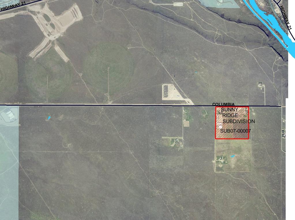
1 Subdivision Staff Report Subdivision Name Sunnyridge Subdivision File Number SUB Approval Preliminary Plat Lead Agency Ada County Annexation Date NA Comp. Plan Complies (With Conditions of Approval) Public Hearing Date April 10, 2007 Heard by Boise City Council Analyst David Abo, AICP Description: This is a proposed residential subdivision with 174 lots and 16 common lots. The site is currently zoned RSW (Southwest Community Residential) and the applicant is requesting a rezone to R8 (Medium High Density Residential) and R12 (High Density Residential). The site is acres in size with a proposed density of 4.36 lots per acre. Location: The site is located on the south side of East Columbia Road approximately 1.73 miles east of Technology Way. Traffic: This development is estimated to generate 1,646 additional vehicle trips per day based on the Institute of Transportation Engineers Trip Generation Manual. Roadway Frontage Functional Classification Traffic Count Columbia 1,300 Local 633 east of Road Technology Way on 2/16/07 Technology N/A Minor Arterial 7,825 south of Way Gowen Road on Level of Service N/A Speed Limit 45 MPH Better 35 MPH Than 2/16/07 C * An acceptable level of service on a two-lane minor arterial roadway is D (14,000 VTD). Special Attention: This subdivision is located outside of any planned fire station response area. The applicant has been working with Boise City Fire Chief Renn Ross who is in the process of requesting an amendment to the Boise City Master Siting Plan to include a new station in the east Columbia Road area. The Boise City Fire Department can recommend approval subject to a condition that
2 2 of 26 the Boise Council must first approve an amendment to the Master Siting Plan to include a future fire station within 1.5 miles of this site. This process may take several months to complete. Contents: Basis for Recommendation Vicinity Map Preliminary Plat Aerial Map Recommended Conditions of Approval Technical Review and Agency Comments
3 3 of 26 Basis for Recommendation The plat design, layout and rezone to R8 and R12 are in conformance with the Boise City Comprehensive Plan if approved with recommended Conditions of Approval. Condition 1 This condition requires East Stanley Basin Drive to stub to the east where Block 2, Lot 11 and part of Lot 12 are currently proposed. Condition 2 This condition requires the applicant to utilize the dimensional standards allowance in section 8-2B-2 of the Ada County Zoning ordinance which provides a 5 foot front yard setback reduction for homes where the garage is either side loaded, or located behind the front plane of the house on at least 50% of proposed lots. This allowance must be used on Block 3, Lots 1-7 and 17-21, and Block 1 Lots 1-6. Condition 3 Condition 4 Condition 5 Condition 6 This condition requires a micropath connection to Block 3, Lot 22 from East Stanley Basin between Lots 8-9, Block 3 and a meandering micropath through Lot 22. This condition requires an amendment to the Boise City Fire Station Master Siting Plan, that includes a future fire station within 1.5 miles of this site, prior to approval of the Final Plat. This condition requires a new detached sidewalk along East Columbia Road. This condition requires Lot 1 and Lots 9-12, Block 9 to utilize alley access for off-street parking. Special note on Sewer Conditions Condition 10 This condition requires compliance with all recommendations of Boise City for connection to Boise City Sewer System. Condition 11 This condition requires verification of compliance of Boise City recommendations on approved Preliminary Plat prior to sewer plan approval. Staff Perspective General The recommended conditions of approval are required to bring the proposed preliminary plat into compliance with the Boise City Comprehensive Plan as determined by the Boise City Comprehensive Planning Staff. Subdivision Staff has reviewed the agency comments and Staff recommends approval based upon Staff's finding that all concerns of the commenting agencies have been addressed. To
4 4 of 26 avoid potential problems the developer is directed to review the concerns identified in the technical reviews to verify that this statement is correct. Street Connectivity The applicant has proposed one direct access point from East Columbia Road as well as a residential collector with one access point on the western property boundary. The applicant is also proposing one stub on the east and south property lines. Staff is concerned that without more stubs, the developments that occur in this area will not be cohesive and interconnected. Specifically, Staff would prefer to see East Stanley Basin Drive stubbed to the eastern property line both for connectivity and for block length. With the inclusion of a stub in this location the block length will be approximately 500 feet which is an adequate length for pedestrian connectivity. The proposed density of 4.4 DU/acre is not one that will support transit in this area however the Planned Community designation allows for flexibility in design and densities creating options outside of this project. Sidewalk The applicant is proposing detached five foot wide sidewalks for all internal streets within the subdivisions. Staff is recommending a condition that a new detached sidewalk be constructed along East Columbia Road.

5

6 1 Preliminary Plat
7

8
9 5 of 26 Recommended Conditions of Approval 1. Stub East Stanley Basin Drive to the east where Block 2, Lot 11 and part of Lot 12 are currently proposed. 2. Utilize the dimensional standards allowance in section 8-2B-2 of the Ada County Zoning ordinance which provides a 5 foot front yard setback reduction for homes where the garage is either side loaded, or located behind the front plane of the house on at least 50% of proposed lots. This allowance must be used on Block 3, Lots 1-7 and 17-21, and Block 1 Lots Construct a micropath between Lot 8 and 9, Block 3, and a meandering micropath through Lot 22, Block 3 from southeast to northwest. 4. Prior to approval of the Final Plat, the Boise City Council must adopt an amendment to the Master Siting Plan to include a future fire station within 1.5 miles of this site. 5. Construct detached sidewalks along East Columbia Road. 6. Lot 1 and Lots 9-12, Block 9 shall utilize alley access for off-street parking. Covenant Requirements 7. Covenants, homeowners association by-laws or other similar deed restrictions acceptable to the Boise City Attorney, which provide for the use, control and maintenance of all common areas, storage facilities, recreational facilities or open spaces shall be reviewed and approved by the Boise City Attorney. Irrigation Conditions 8. Comply with Boise City Code Section J and Idaho Code, Section concerning pressure irrigation requirements prior to signing of the Final Plat by the Boise City Engineer. A. The owner or person, firm or corporation filing the subdivision plat shall provide a pressurized irrigation system. The system must conform to the minimum design standards and specifications of Boise City or of the entity that will operate and maintain the system, if that entity has published standards. Fees: Developer and/or owner shall pay the current inspection and plan review fees on the proposed subdivision prior to signing of the Final Plat by the Boise City Engineer (B.C.C A.2).
10 6 of 26 B. Developer may construct prior to Final Platting or bond in the amount of 110% of the estimated construction costs. C. Prior to either commencing construction or signing of the Final Plat by the Boise City Engineer, developer shall: 1) Submit construction plans and specifications for the pressurized system, stamped by a registered engineer, to the Boise City Public Works Department and acquire approval there from. 2) Provide written assurance that provisions have been made for ownership, operation, and maintenance of the system. 3) Delineate all necessary irrigation easements on the Final Plat (B.C.C F). 9. Developer shall provide for an independent inspection of the installation of irrigation facilities and written certification by the design or project engineer that the system was installed according to the approved plans. In addition, the Boise City Public Works Department must be present for the system pressure test and participate in a final inspection. Sewer Conditions 10. Compliance with all recommendations of the Boise City Council is required for connection to the City of Boise sewer treatment system. 11. Prior to approval of sewer construction drawings by the Boise City Public Works Department, the Preliminary Plat approved by Ada County shall be reviewed and approved for compliance with all the recommendations of the Boise City Council, by the Boise City Subdivision Staff. The Boise City Subdivision Staff shall provide written verification to the Boise City Public Works Department. 12. The developer and/or owner shall delineate all necessary Boise City sanitary sewer easements on the Final Plat prior to signing of the Final Plat by the Boise City Engineer (B.C.C F). 13. Wet line sewers are required (B.C.C D). A. Developer/owner shall contact the Public Works Department regarding the financing and details of extending the sewers to the subject property. Developer shall enter into a sewer reimbursement contract with the City of Boise. B. Plans shall be submitted to and approved by the Boise City Public Works Department prior to commencing with construction. Developer/owner may either
11 7 of 26 construct improvements prior to Final Platting or execute a performance agreement and provide surety in the amount of 110% of the estimated costs. The developer shall coordinate with the Public Works Department for construction inspection prior to and during construction. Unless otherwise approved by the Public Works Department, all sewer construction shall be completed and accepted within 90 days of plat recordation or within 30 days of issuance of the first building permit within the subdivision, whichever comes first. NOTE: All bonding shall conform to Boise City Code, Title 8, Chapter 20. C. Developer/owner shall pay the current sewer inspection fees for the proposed subdivision prior to signing of the Final Plat by the Boise City Engineer. D. All lots within this subdivision shall be subject to and restricted by the following recorded subdivision covenants: 1) A monthly sewer charge must be paid after connecting to the Boise City public sewer system, according to the ordinances and laws of Boise City. 2) Owner shall submit to inspection by either the Public Works Department or the Building Department whenever a subdivided lot is to be connected to the City's sewage system and a building is constructed or installed on or within the owner's property. 3) The developer/owner of this subdivision or lot or lots therein shall and hereby does vest in Boise City the right and power to bring all actions against the owner of the premises hereby conveyed or any part thereof for the collection of any charges herein required and to enforce the conditions herein stated. This covenant shall run with the land. 4) The recording of this plat by developer/owner shall be deemed and construed as a request for annexation of its property to the corporate limits of Boise City. Such request and consent shall be binding on all subsequent purchasers or owners of developer's property. 5) Covenants to be approved by the Boise City Attorney. 14. Developer and/or owner shall construct sewer or pay a sewer assessment along Columbia Road and/or as may be approved by the Boise City Public Works Commission prior to signing of the Final Plat by the Boise City Engineer. Contact the Department of Public Works for specific costs. Street Light Conditions
12 8 of Developer shall delineate on the face of the Final Plat a Boise City street light easement, acceptable to the Boise City Department of Public Works, for the purpose of installing and maintaining city-owned street light fixtures, conduit and wiring lying outside the dedicated public right-of-way (B.C.C F). 16. The developer shall be required to install, at their expense, street lights in accordance with Boise City Public Works specifications and standards at locations designated by the Public Works Department (B.C.C H.1). Plans shall be reviewed and approved by the Boise City Public Works Department prior to commencement of construction, bonding, or payment into trust fund. A. Fees: Developer shall pay the current street light inspection and plan review fees on the proposed subdivision (B.C.C A.2). B. The street lights shall be installed and accepted by the Boise City Public Works Department at the following locations. 26 street lights 25ft. minimum mounting height, 100 W.H.P.S. N.E. Corner Lot 15, Block 4 N.W. Corner Lot 7, Block 4 S.E. Corner Lot 5, Block 5 N.E. Corner Lot 1, Block 6 S.E. Corner Lot 6, Block 1 N.E. Corner Lot 4, Block 7 N.W. Corner Lot 38, Block 9 N.W. Corner Lot 5, Block 9 N.E. Corner Lot 11, Block 9 N.W. Corner Lot 6, Block 2 N.E. Corner Lot 15, Block 2 N.E. Corner Lot 13, Block 12 N.E. Corner Lot 1, Block 3 N.E. Corner Lot 7, Block 3 N.E. Corner Lot 14, Block 3 N.E. Corner Lot 6, Block 12 N.E. Corner Lot 22, Block 3 60ft. North of the S.W. Corner Lot 3, Block 9 360ft. North of the S.W. Corner Lot 3, Block 9 S.W. Corner Lot 1, Block 4 300ft. North of the S.W. Corner Lot 1, Block 4 N.W. Corner Lot 1, Block 4 N.E. Corner Lot 1, Block 4 230ft. East of the N.W. Corner Lot 1, Block 1
13 9 of ft. East of the N.W. Corner Lot 1, Block 1 N.W. Corner Lot 1, Block If bonding approval is granted by the Boise City Public Works Department, developer may bond in the amount of 110% of the estimated street light costs. Street lights shall be installed within 90 days of the issuance of the first building permit in the development, if building permits are obtained prior to completion of street light improvements. General Conditions 18. The developer shall make arrangements to comply with all requirements of the Boise City Fire Department and verify in one of the following ways: A. A letter from the Boise City Fire Department stating that all conditions for water, access, and/or other requirements have been satisfied, OR B. A non-build agreement has been executed and recorded with a note on the face of the Final Plat identifying the instrument number. NOTE: 1) For streets having a width less than 36 feet back of curb to back of curb parking shall be restricted on (1) one side; for streets having a width less than 29 feet back of curb to back of curb parking shall be restricted on both sides; and for standard ACHD cul-de-sacs parking shall be restricted on both sides. A note on the face of the Final Plat is required noting the parking restriction prior to signing of the Final Plat by the Boise City Engineer. 2) "No Parking" signs and curb painting shall be required on streets having a width less than 36-feet, back of curb to back of curb. Contact the Boise City Fire Department for sign placement and spacing. Developer may either construct prior to Final Platting or post bond in the amount of 110% of the estimated costs with the Boise City Planning and Development Services Department. 19. Prior to submitting the Final Plat for recording, the following endorsement or certification must be executed: Certificate of the Boise City Engineer stating, I, the undersigned Boise City Engineer, hereby state that the recommended conditions of Boise City have been satisfied for the Sunnyridge Subdivision. (I.C. Title 50, Chapter 13).
14 10 of 26 Technical Review and Agency Comments Boise City Planning and Development Services: Subdivision Section David Abo, AICP The subdivision must comply with Boise City Comprehensive Plan and conditions of the Boise City Public Works Department. Comprehensive Planning Section Jennifer Tomlinson, March 28, 2007 Boise City is providing comment on the above-listed application relative to its consistency with the goals and policies of the Boise Comprehensive Plan and pursuant to the requirements of the Area of Impact Agreement. The subject property is located along East Columbia Road and contains acres. This is an application for a Preliminary Plat to include 174 residential lots and 16 common lots, a Zone Change from Rural Urban Transition (RUT) to Medium High Density (R8) and High Density Residential (R12) and a Development Agreement. This property is in the Southeast Planning Area and has been designated on the Land Use Map as Planned Community. The following Comprehensive Plan chapter policies have applicability to this application: Specific Policies of the Southeast Planning Area are applicable to project: Chapter 8 Land Use Objective The Columbia Planned Community area shall be developed according to the following principles: -Overall developed density of the Columbia area, including open space, roads and other uses, shall not exceed four units per gross acre. -Residential densities shall be higher in areas adjacent to the Micron Tech Park and other activity areas and shall seek to form a community center. -The Planned Community area shall identify appropriate locations for neighborhood- and community-serving commercial uses, schools, fire stations and parks. -Pedestrian pathways and bike lanes shall connect land uses within the Planned Community area. -Land use restrictions of the Airport Influence Area shall be adhered to as described in Chapter 3 Section 3.3 Noise Goals, Objectives and Policies. -Groundwater restrictions of the Southeast Groundwater Management Area shall be adhered to.
15 11 of 26 -Groundwater supplies of other areas shall not be jeopardized to serve the Columbia area; attainment of the maximum unit count for Columbia shall be contingent on adequate water sources. -A master plan that demonstrates adherence to these principles shall be submitted to the Planning and Zoning Commission for approval prior to further entitlement in the Columbia area. -Any master plan shall address a minimum of 100 acres. Chapter 6-Transportation Objective Encourage completion of the existing street system and creation of new links, within reasonable constraints, as the transportation system develops. Policy All new development shall be reviewed for appropriate opportunities to connect to local roads and collectors in adjacent developments. Objective Promote land use policies that limit access as necessary to maintain safe and efficient operation of the existing street system while allowing reasonable access to individual development parcels. Policy Improve access control on existing streets through the review of new developments. Objective Maintain safe and comfortable neighborhoods by minimizing speeding and cutthrough traffic. Policy Encourage traffic-calming in a way that minimizes adverse effects on adjacent streets. Objective Implement pathway plans as quickly as funding permits while retaining flexibility in the location and implementation stages of pathway development. Policy Require the provision of pathways, when consistent with the Ada County Ridgeto-Rivers Pathway Plan and/or the Boise Comprehensive Park and Recreation System Plan, in the following cases: a) In new projects b) When improvements are made to existing bridges, roads, open space areas or other structures by public or private entities; c) If the area in question would provide an important link in the pathway network. Chapter 7- Community Quality Objective 7.6- Promote energy efficiency in new and existing housing. Policy Promote energy conservation features in the design of all new housing developments and encourage installation of conservation devices in existing equipment.
16 12 of 26 Residential Development Objective 7.2- Ensure through urban design the development of new residential structures that are functional and aesthetically pleasing. Policy 7.4- Require that residential street scenes provide variety and modulation in design and placement of homes. Objective 7.4- Reinforce the development of functional and visually appealing neighborhoods. Policy Establish a continuous network of sidewalks, bicycle and/or pedestrian paths to establish internal and external linkage within the community. Chapter 8- Land Use Goal 8.0- Achieve a city that minimizes suburban sprawl that provides for a diverse mixture of lifestyles and atmospheres and a sense of place that varies throughout the different areas of the city, and that efficiently provides basic services and facilities in close proximity to where people live. Objective 8.1- The land use map and attendant policies shall be the official guide for development of the planning area and shall be implemented through zoning and development review. Policy The Land use/zoning Consistency Matrix shall identify the zoning districts that are permissible within each land-use designation. Conformance with the Land Use/Zoning Consistency Matrix shall be a necessary finding of approval for all zone changes and conditions uses, unless one or more of the forms of flexibility identified in the policies under Objective 2 are implemented. Land Use A U R- 1A R- 1B R- 1C R- 1M R- 2 R- 3 N- O L- O R- O C- 1 C- 2 C- 3 C- 4 C- 5 PC H- S M- 1 M- 2 M- 4 T- 1 T-2 Planned Community 3) X X X X X X X X X X X X X X X X X X X X X Table Definitions of Land Use Map Designations Page 2 of 3 Land Use Applies To Allowed Uses and/or Limitations FAR Planned Community Vacant areas larger than 100 gross acres Accommodates maximum flexibility in project design, within preestablished parameters. Master Plan required by applicant for review and approval by Planning and Zoning Commission before processing of development entitlement. Master Plan must depict general location of proposed land-uses, including roads, any shopping areas, schools, parks, fire stations or other facilities. Must follow area-specific policies in Comprehensive Plan Land Use Chapter for maximum densities, unit caps, type of land uses and other issues. Once the Master Plan is approved, development entitlement may proceed quickly. Master Plans may be amended by Planning and Zoning Commission as necessary to react to changing markets and community needs. Specific plans may be developed, or standard zoning may be used. None
17 13 of 26 Objective 8.3-Achieve a compact city comprised of a central Downtown with surrounding neighborhoods that have a center focus combining residential, commercial, employment, civic, cultural and recreational uses. Policy Development projects shall cumulatively form communities that have a center focus combining residential, commercial, employment, civic, cultural and recreational uses. Objective 8.6- Residential land uses shall be designated to provide a variety of housing densities, product types and affordable costs, and shall be located and distributed in a manner that is compatible with adjacent uses and promotes transit and pedestrian activity. Policy Residential development projects greater than 10 acres shall be encouraged to provide a combination of product types and densities rather than a single product type. Chapter 9-Economic Development Policy Ensure that sufficient housing opportunities are provided in the Boise Planning area to provide a labor force that is in balance with available jobs. Chapter 10-Growth Management Goal Preserve, protect and enhance the overall quality of life in Boise and its Area of Impact by ensuring that growth occurs in an orderly manner and that public services are available along with development. Objective 10.1-Ensure that growth is planned and directed in a way that minimizes sprawl and creates a functional and pleasing community. Figure 10-1 Level of Service Standards for Community Services and Facilities Service Service Standards Service Area TYPE I CONCURRENT WITH THE ISSUANCE OF ANY DEVELOPMENT PERMIT Fire* 4 minute response, unless excepted by Fire Department 1.5 mile Water 35 psi residential/1,500 gpm fire flow Community 40 psi non-residential/1,500 gpm fire flow Community Sewer ** Available to site Community Treatment: Federal Standards + capacity Collection: capacity Schools System capacity Community Streets Authorization by ACHD Community Police/Sheriff Available Solid Waste Weekly pick-up Community Electricity Available Community
18 14 of 26 Telephone Available Community Storm Drainage Approved on site or public system Community * Fire Station set-a-side shall be required within the City Area of Impact. ** See the exception for the Southwest Planning Area identified under Objective 2, Policy 2 in the Sewer Facilities section of the Public Facilities, Utilities and Services chapter of this plan. ANALYSIS The applicant is proposing a total of 174 buildable lots and 16 common lots on acres, a Zone Change from Rural Urban Transition (RUT) to Medium High Density (R8) and High Density Residential (R12) and a Development Agreement. The proposed density of the development is 4.4 DU/acre. Chapter 6-Transportation-Because this applicant is the first to bring a project forward in this area, street connectivity within the development as well as stubs to other properties are critical to ensuring that the street system is developed cohesively in the area. The Comprehensive Plan calls for master planning a minimum of 100 acres, however it has been determined that if other landowners in the area are not willing to work together to master plan the area, staff will not recommend denial of an application based solely on its size. Because of the size, it will be necessary for a clear coherent street system to begin to develop. The applicant has proposed one direct access point from East Columbia Road as well as a residential collector with one access point on the western property boundary. The applicant is also proposing one stub on the east and south property lines. Staff is concerned that without more stubs, the developments that occur in this area will not be cohesive and interconnected. Specifically, staff would prefer to see East Stanley Basin Drive stubbed to the eastern property line both for connectivity and for block length. With the inclusion of a stub in this location the block length will be approximately 500 feet which is an adequate length for pedestrian connectivity. The proposed density of 4.4 DU/acre is not one that will support transit in this area however the Planned Community designation allows for flexibility in design and densities creating options outside of this project. Chapter 7-Community Quality- The applicant is proposing a total of 174 buildable lots. The subdivision will have 68% or 119 units in the R8 zone and 32% or 55 lots in the R12 zone. Staff finds the mix of housing types, specifically the alley loaded lots in a good location fronting onto the common open space area. Staff is concerned that the overall lotting pattern could lead to a garage dominated street scene and recommends that the applicant utilize the five foot front yard setback allowance through the Ada County Zoning Ordinance for lots that have either sideloaded garages or garages located behind the front plane of the house for the traditional single family lots. Since the proposed development is the first in the area, staff would prefer to see the development of a trail system that can be connected through future developments. The Idaho Power easement on the southwestern portion of the property, currently shown as open space will provide an excellent opportunity to start a trail system for this area. The applicant has proposed detached sidewalks throughout the development, setting the precedent for detached sidewalks in this area. Chapter 8-Land Use-The applicant is proposing a residential subdivision with a density of 4.4 DU/acre. The proposed subdivision is in the Planned Community Designation on the Future
19 15 of 26 Land Use Map, and located within the Southeast Planning area. Specific policies of the southeast planning area indicate an overall developed density of no more than 4 units per gross acre with residential densities higher in areas adjacent to the Micron Tech Park. The proposed subdivision is located about a mile and a half from the Micron Tech Park and will provide a needed product near an employment center. Chapter 10-Growth Management The proposed development is located outside of the response area of Fire Station 12. The applicant and the Fire Department have determined that amending the Boise Fire Department Master Siting Plan to include a station that can serve this area will be necessary. RECOMMENDATION Summary of Comprehensive Plan Review Does project comply with Land Use Policies? Yes Does project comply with Pathway Policies? Yes with conditions Does project comply with Street Policies? Yes with conditions Does project comply with Growth Management Policies? No Staff finds that the proposed development of the Sunnyridge Subdivision on East Columbia Road can be compliant with the Boise City Comprehensive Plan and recommends forwarding a recommendation of approval to Ada County. Should the County approve the preliminary plat for Sunnyridge Subdivision; Staff would recommend that the following conditions be adhered to in order to bring the proposed development into compliance with the Boise City Comprehensive Plan; 1. Stub East Stanley Basin Drive to the East where Block 2, Lot 11 and part of Lot 12 are currently proposed. 2. Utilize the dimensional standards allowance in section 8-2B-2 of the Ada County Zoning ordinance which provides a 5 foot front yard setback reduction for homes where the garage is either side loaded, or located behind the front plane of the house on at least 50% of proposed lots. This allowance must be used on Block 3, Lots 1-7 and 17-21, and Block 1 Lots Construct a micropath between Lots 8-9, Block 3, and a meandering pathway through Lot 22 from southeast to northwest. 4. Prior to approval of the Final Plat, the Boise City Council must adopt an amendment to the Master Siting Plan to include a future fire station within 1.5 miles of this site. 5. Construct detached sidewalks along East Columbia Road. Boise City Public Works: Engineering Rob Bousfield No comment. Pressure Irrigation - Kent Johnson
20 16 of 26 Comply with Boise City Code Section J and Idaho Code, Section Sewer - John Johnson, February 2, 2007 Wet line sewers are required. Sewer inspection fees required. Sewer easements required. Covenants required for sewer charges, connections and request for annexation. Sewer assessment required along Columbia Road. Street Lights - Henry Alarcon, March 28, street lights required. Boise City street light easement(s) required. Boise City Fire Department As amended by Dave Hanneman, March 23, 2007 The Boise Fire Department has reviewed this application based upon additional information and can conditionally approve the Preliminary Plat. Any deviation from this plan is subject to Fire Department approval. Please note that unless stated otherwise this memo represents requirements of the International Fire Code as adopted and amended by Ordinance Fire Department vehicular access shall be provided to within 150' of all portions of the nonsprinklered buildings. This distance can be increased somewhat for sprinklered buildings but exact distances are on a case-by-case basis. All Fire Department access roads, fire lanes, bridges, and gates are to be a minimum of 20' wide with 13' 6" overhead clearance, shall be capable of supporting 70,000 lbs GVW (24,000 lbs per axle), and shall be paved. Fire Department access roads and fire lanes shall have a minimum outside turning radius of 48' with an inside radius of 28'. Any dead-end road in excess of 150' needs a Fire Department approved turn around. No grade may exceed 10% (please note that fire apparatus are designed for a maximum 6% grade). Dead end roads or roads with a single point of access from a multi-access street are prohibited from exceeding 700 feet. Width and turning radius measurements specified by this paragraph can include those surfaces vehicles generally drive upon. Specifically, gutter and rolled curb are generally considered useable, while vertical curb or sidewalks are not. This subdivision is accessed off of the extremely long single access dead-end Columbia Road. This development is not within the 1.5 mile/4 minute response standards of the existing fire station number 12 on Gowan Road. Prior to approval of the Final Plat, the Boise Council must approve an amendment to the Master Siting Plan to include a future fire station within 1.5 miles of this site. Some hydrants have been noted. In the absence of information on existing hydrants it appears that 1 more hydrant will be needed on Clear Ridge Street and 1 more hydrant will be needed on Snow Bird Avenue. However, we reserve the right to modify requirements as more information comes to light. Variables that affect hydrant numbers and location include, but are not limited to, area, construction type, existing hydrants, accuracy of information provided in the application, strategic location for fire fighting forces, and required fire flow. Maximum hydrant
21 17 of 26 spacing for this project is 500 feet between hydrants. New hydrants shall be "non-private" installations. For streets having a width less than 36 feet back of curb to back of curb parking shall be restricted on (1) one side; for streets having a width less than 29 feet back of curb to back of curb parking shall be restricted on both sides; and for standard ACHD cul-de-sacs parking shall be restricted on both sides. A note on the face of the Final Plat is required noting the parking restriction prior to signing of the Final Plat by the Boise City Engineer. In addition, No Parking signs shall be installed in accordance with the requirements of the IFC. Fire Department required fire hydrants, access, and street identification shall be installed prior to construction or storage of combustible materials on site. Provisions may be made for temporary access and identification measures. Specific building construction requirements of the International Building and International Fire Codes will apply. However, these provisions are best addressed by a licensed Architect at building permit application. Please feel free to have the applicant contact David S. Miller, Ada County Highway District Mindy Wallace, March 14, 2007 A. Findings of Fact Existing Conditions 1. Site Information: The site is currently vacant. 2. Description of Adjacent Surrounding Area: Direction Land Use Zoning North Single-family/agricultural RUT South Single-family/ agricultural RUT East Single-family/ agricultural RUT West Single-family/agricultural RUT 3. Existing Roadway Improvements and Right-of-Way Adjacent To and Near the Site Columbia Road is currently improved with 2 traffic lanes, and no curb gutter or sidewalk abutting the site. There is 60-feet of right-of-way existing for Columbia Road (30-feet from centerline). Technology Way is currently improved with 2 traffic lanes, and not curb gutter or sidewalk. There is 90-feet of right-of-way existing for Technology Way (45-feet from centerline).
22 18 of Existing Access: There are 4 defined access points to this property located off of Columbia Road. 5. Site History: ACHD has not previously reviewed this site for a development application. Development Impacts 6. Trip Generation: This development is estimated to generate 1,646 additional vehicle trips per day based on the Institute of Transportation Engineers Trip Generation Manual. 7. Impact Fees: There will be an impact fee that is assessed and due prior to issuance of any building permits. The assessed impact fee will be based on the impact fee ordinance that is in effect at that time. 8. Impacted Roadways: Roadway Frontage Functional Classification Traffic Count Columbia 1,300 Local 633 east of Road Technology Way on 2/16/07 Technology N/A Minor Arterial 7,825 south of Way Gowen Road on Level of Service N/A Speed Limit 45 MPH Better 35 MPH Than 2/16/07 C * An acceptable level of service on a two-lane minor arterial roadway is D (14,000 VTD). 9. Capital Improvements Plan/Five Year Work Program There are currently no roadways, bridges or intersections in the general vicinity of the project that are currently in the Five Year Work Program or the District Capital Improvement Program (CIP). B. Findings for Consideration 1. Reclassification of Columbia Road Currently, Columbia Road is a local roadway abutting the site carrying approximately 630 vehicle trips per day. This development alone is projected to add an additional 1,646 vehicle trips per day. Based on the existing function of that roadway to collect and carry traffic to HWY 21, District staff recommends that Columbia Road be re-classified with this Commission action as a collector roadway from its terminus/intersection Eyelet Street at the east end of Columbia Road to its intersection with Technology Way on the west. The roadway will collect traffic from the surrounding subdivisions, including this site and carry the traffic to Technology Way. 2. Columbia Road
23 19 of 26 Right-of-Way Policy: District policy requires 70-feet of right-of-way on collector roadways (Figure 72-F1B). This right-of-way width allows for the construction of a 3- lane roadway with curb, gutter, 5-foot wide detached sidewalks and bike lanes. Street Section Policy: District policy 72-F1B requires collector roadways to be constructed as 46-foot street sections with vertical curb, gutter, and 5-foot detached (or 7- foot attached) concrete sidewalks within 70-feet of right-of-way. This street section allows for the construction of a 3-lane roadway with bike lanes. Sidewalk Policy: District policy requires 7-foot wide attached (or 5-foot detached) concrete sidewalk on all collector roadways and arterial roadways ( ). Applicant s Proposal: The applicant has proposed to widen Columbia Road with 18- feet of pavement from the centerline and to construct curb and gutter abutting the site. Staff Comment/Recommendation: Based on the use, anticipated volumes and functional classification of Columbia Road as a collector, District staff believes that a full 46-foot collector street section (including bike lanes and a center turn lane) is not warranted on this roadway for its full length. Therefore, District staff recommends that the applicant widen the pavement on Columbia Road to one-half of a 36-foot street section with vertical curb, gutter, and a 5-foot detached (or 7-foot attached) concrete sidewalks abutting the site. This street section would provide for two travel lanes and bike lanes, with no parking. In lieu of providing a center turn lane for the entire length of the roadway (Columbia Road) abutting the site, as would be standard with a collector roadway, District staff recommends that the applicant construct a center turn lane at the site entrance intersection with Columbia Road only, in lieu of constructing one-half of a 46-foot street section for the full length of the project. 3. Residential Collector Residential Collector Policy: District policy 72-F1A, and , requires that residential collectors be constructed as 36-foot street sections with curb, gutter and 5- foot wide concrete sidewalks with no front-on housing within 50-feet of right-of-way. The access restrictions for these street segments should be stated on the Final Plat. Unless otherwise noted, parking should be prohibited on these street segments. Coordinate the signage Program with District staff. Island Policy: District policy and require islands to be constructed a minimum of 4-feet wide with a minimum area of 100-square feet and designed to safely channel traffic. The roadway on either side of the traffic island should maintain a minimum of a 21-foot street section. District policy also requires any proposed landscape islands/medians within the public right-of-way dedicated by this plat should be owned and maintained by a homeowners association. Notes of this should be required on the Final Plat. The design should be reviewed and approved by ACHD's Development staff.
24 20 of 26 Applicant s Proposal: The applicant has proposed to construct a residential collector within the site with two 17-foot travel lanes, a 10-foot center landscape island, and 5-foot landscape strips with in 65-feet of right-of-way with 4-foot detached concrete sidewalks. Staff Comment/Recommendation: The applicant s proposal meets District policy, however the applicant will be required to provide a minimum 21-foot street section on either side of the center landscape islands, and construct a 5-foot detached concrete sidewalk in lieu of a 4-foot sidewalk. Provide a public use easement to the District for any segment of the sidewalk located outside of the right-of-way. Because there is a limited transportation system currently in place in this section of the county; there are no section line or mid-section line roadways existing other than Columbia Road. Future development is anticipated in the area, and in order to plan for and provide an adequate transportation system for the future, the applicant will be required to continue the residential collector through the site and stub it to the south property line. The residential collector will need to be constructed as a 36-foot street section with vertical curb, gutter, and sidewalk with no front-on housing and parking prohibited. The residential collector will help serve the properties to the south and provide adequate access to Columbia Road without the potential to put the other local street stubs over their planned capacity. In addition, this residential collector or possibly other future collectors could eventually be constructed, through the development process, to connect to the eventual extension of Technology Way to the interstate. 4. Internal Streets Right-of-Way Policy: District policy and Figure 72-F1A requires 50-feet of right-of-way on local streets. This right-of-way allows for the construction of a 2-lane roadway with curb, gutter and 5-foot wide concrete sidewalks. 33-foot Street Section Policy: District policy 72-F1A, allows local residential public roads with a 33-foot street section with parking on both sides of the roadway, if the amount of vehicle trips per day on the street does not exceed 1,000 and the appropriate fire department reviews and approves the street section. The proposed density of development that will utilize the internal local residential streets is anticipated to generate less than 1,000 vehicle trips per day. Applicant Proposal (Internal streets): The applicant has proposed to construct the internal streets as a 33-foot street section with two 14.5-foot travel lanes, 5-foot planter strip, and curb and gutter within 50-feet of right-of-way. The applicant has proposed to construct 4-foot detached concrete sidewalk located outside of the right-of-way. Staff Comment/Recommendation: The applicant s proposal for the 33-foot street section meets District policy and should be approved with this application. The applicant will be required to receive fire department approval for the reduced street section. The applicant will be required to construct a 5-foot concrete detached sidewalk walk in lieu of
25 21 of 26 a 4-foot sidewalk. Provide a public use easement to the District for any segment of the sidewalk located outside of the right-of-way. 5. Turnarounds Turnaround Policy: District policy requires turnarounds to be constructed to provide a minimum turning radius of 45-feet. Landscape and parking islands may be constructed in turnarounds if a minimum inside curb radius of 28-feet, and a minimum outside radius of 45-feet are provided. The pavement width shall be sufficient to allow the turning around of a standard AASHTO SU design vehicle without backing. Applicant s Proposal: The applicant has proposed to construct two cul-de-sac turnarounds with center landscape islands. Staff Comment/Recommendation: The applicant s proposal meets District policy and should be approved as proposed. The applicant will be required to provide a 29-foot street section around the center landscape islands, and provide a minimum turning radius of 45-feet. 6. Knuckles Knuckle Policy: District policy District policy and and the local Fire District standards require an island within a knuckle to be constructed with the island being a minimum of 4-feet wide with a minimum area of 100-square feet and designed to safely channel traffic. The roadway around the traffic island should maintain a minimum of a 29-foot street section. The design should be reviewed and approved by ACHD's Development staff. Applicant s Proposal: The applicant has proposed to construct one knuckle. Staff Comment/Recommendation: The applicant s proposal meets District policy and should be approved with this application. 7. Alleys Alley Policy: District policy requires the minimum right-of-way width for new alleys to be 16-feet if: the alley is abutted by residential uses and zoning on both sides; and building setbacks required by the land use agency having jurisdiction provide sufficient space for the safe backing of vehicles into the alley; and 20-feet in all other situations. Dedication of clear title to the right-of-way and the improvement of the rightof-way, and acceptance of the improvement by the District as meeting its construction standards, are required for all alleys contained in a proposed development. The alley shall be improved by paving the full width and length of the right-of-way; provided, that the minimum width of the right-of-way is 16-feet and the homeowners association has obtained a license agreement from the District authorizing the landscaping of a portion of the alley right-of-way, which a portion abuts the development and does not exceed two feet in width, such licensed area need not be paved until the license is terminated.
26 22 of 26 Alley Design Policy: District policy states that alleys shall connect to a public street at each end and shall not terminate in dead-ends. Alleys with curves are not allowed without specific District approval taken on good cause shown. Curves shall have a minimum inside radius of 26-feet. Alley Intersection Policy: District Policy states a minimum of back-of-curb radius of 15-feet is required at all alley intersections. For the reconstruction of existing alleys, the back-of-curb radius may be less than 15-feet when it is impractical to remove existing obstructions. Alley Access Policy: Access is allowed to and from a fully improved alley (District policy ). Parking shall be designed so the minimum clear distance from the back of the parking stall to the opposite side of the alley is 22-feet for perpendicular parking. An access to an alley shall be located a minimum of 25-feet from the nearest public street. Applicant s Proposal: The applicant has proposed to construct four 20-foot wide alleys. Three of the alleys are straight and intersect a public street at both ends. One of the alleys has a turn and intersects a three-way intersection. Staff Comment/Recommendation: The applicant s proposal for the three straight alleys that intersect a public street at both ends meet District Policy and should be approved with this application. The alley with the turn that intersects a three-way intersection does not meet current District policy and will need to be constructed as a private alley or re-designed to meet public alley standards. 8. Stub Streets Stub Street Policy: District policy states that the street design in a proposed development shall cause no undue hardship to adjoining property. An adequate and convenient access to adjoining property for use in future development may be required. If a street ends at the development boundary, it shall meet the requirements of sub section 7205, non-continuous streets. District policy states that stub streets will be required to provide intra-neighborhood circulation or to provide access to adjoining properties. Stub streets will conform with the requirements described in Section , and , except a temporary cul-de-sac will not be required if the stub street has a length no greater than 150-feet. A sign shall be installed at the terminus of the stub street stating that, "THIS ROAD WILL BE EXTENDED IN THE FUTURE". Applicant s Proposal: The applicant has proposed to construct one stub street to the east, one stub street to the west, and one stub street to the south. The stub streets are proposed to be constructed in the following locations:
27 23 of 26 Stub street to the east, located approximately 1,270-feet south of the north property line (measured property line to centerline). Stub street to the west, located approximately 480-feet south of the north property line (measured property line to centerline). Stub street to the south, located approximately 160-feet east of the west property line (measured property line to centerline). Staff Comment/Recommendation: The applicant s proposal meets District policy and should be approved with this application, however in lieu of constructing the proposed stub street to the south the applicant may construct one residential collector stub street to the south property line, as identified in Finding for Consideration #3. 9. Tree Planters Tree Planter Policy: The District s Tree Planter Width Interim Policy prohibits all trees in planters less than 6-feet in width. In addition to prohibiting trees in planters less than 6-feet in width, the policy requires a minimum planter width of 6-feet for class II tress with the installation of root barriers on both sides of the planter strip or a minimum planter width of 8-feet without the installation of a root barrier. The policy also requires Class I and Class III trees to provide a minimum planter width of 10-feet. 10. Other Access With this application Columbia Road will be classified as a collector roadway. Other than the access specifically approved with this application, direct lot access is prohibited to this roadway and should be noted on the Final Plat. C. Special Recommendation to Ada County & Boise City Over the last several months, the District has reviewed multiple development applications in this area south of State Highway 21 and east of Technology Way. Portions of this area are located within the City of Boise s Impact Area and the remainder is within the County. Due to the limited infrastructure, the minimal existing development, and the potential for future development in this area, the District anticipates that a master planning or sub-area planning process would be beneficial to determine the potential land uses and subsequently the necessary transportation infrastructure needed in this area of the County. D. Site Specific Conditions of Approval 1. Dedicate 25-feet of right-of-way from the centerline of E. Columbia Road abutting the site.
Subdivision Staff Report
 Subdivision Staff Report Name: Brownstone Subdivision Date: May 12, 2004 File: SUB04-00041 Meeting: May 18, 2004 Approval: Preliminary To: City Council Lead Agency: Ada County (04-10-S) From: Richard Beck
Subdivision Staff Report
 Subdivision Staff Report Subdivision Name Coldstream File Number SUB06-00040 Subdivision Approval Preliminary Plat Lead Agency Boise City Annexation Date December 9, 1974 Comp. Plan Complies Public Hearing
Amended Subdivision Staff Report
 Amended Subdivision Staff Report Subdivision Name Silverpine Subdivision File Number SUB06-00052 No.2 Approval Preliminary Plat Lead Agency Ada County Annexation Date NA Comp. Plan Complies (With Conditions
Subdivision Staff Report
 Subdivision Staff Report Subdivision Name Toli Park Subdivision File Number SUB07-00035 Approval Preliminary Plat Lead Agency Boise City Annexation Date December 30, 1987 Comp. Plan Complies Public Hearing
Let me know if I need to bring you any other documentation for this withdrawl. Thanks!
 >>> david benoit 11/27/2007 10:00 AM >>> Dave, I am set to be heard on the Cranston Corner Subdivision on December 4th in front of City council. I have sold this property and am requesting
Time Extension Staff Report
 Time Extension Staff Report Subdivision Name Lunara Subdivision File Number SUB07-00019 Approval Time Extension for Lead Agency Boise City Certification Signature of Boise City Engineer Annexation Date
Subdivision Staff Report
 Subdivision Staff Report Name: Madronawood Subdivision Date: January 26, 2005 File: SUB05-00005 Meeting: February 1, 2005 Approval: Preliminary To: City Council Lead Agency: Ada County (04-31-S) From:
Subdivision Staff Report
 Subdivision Staff Report Subdivision Name Honeymoon Cove Subdivision File Number SUB08-00005 Approval Preliminary/ Final Plat Lead Agency Boise City Annexation Date December 30, 2004 Comp. Plan Complies
Subdivision Staff Report
 Subdivision Staff Report Subdivision Name Madera Creek File Number SUB06-00068 Subdivision Approval Final Plat Lead Agency Boise City Annexation Date December 9, 1974 Comp. Plan Complies Public Hearing
Hal Simmons Planning Director Boise City Planning and Development Services. CAR / 1689 South Entertainment Avenue
 MEMORANDUM MEMO TO: FROM: Mayor and Boise City Council Hal Simmons Planning Director Boise City Planning and Development Services DATE: November 15, 2008 RE: CAR08-00019 / 1689 South Entertainment Avenue
RE: CAR / 4280 N.
 MEMORANDUM TO: FROM: Mayor and Boise City Council Hal Simmons - Planning Director Boise City Planning and Development Services DATE: April 29, 2009 RE: CAR09-00006 / 4280 N. Eagle Road The following application
Time Extension Staff Report
 Time Extension Staff Report Subdivision Name Therrin Subdivision File Number SUB06-00020 Approval Time Extension for Lead Agency Boise City Certification Signature of Boise City Engineer Annexation Date
Subdivision Staff Report
 Subdivision Staff Report Subdivision Name Birmingham Place File Number SUB06-00051 Subdivision Approval Preliminary/Final Plat Lead Agency Boise City Annexation Date December 3, 1962 Comp. Plan Complies
Location: The subject property is located at the northeast corner of S. Holden Lane and E. Boise Avenue.
 Subdivision Staff Report Subdivision Name Tianna Park File Number SUB11-00008 Approval Preliminary Plat Lead Agency Boise City Annexation Date December 19, 1977 Comp. Plan Complies Public Meeting Date
Subdivision Staff Report
 Subdivision Staff Report Subdivision Name Greenfield Park File Number SUB06-00110 Subdivision Approval Preliminary/Final Plat Lead Agency Boise City Annexation Date December 9, 1974 Comp. Plan Complies
May 21, ACHD Board of Commissioners Stacey Yarrington, Planner II DRH /DRH
 Development Services Department May 21, 2013 TO: FROM: SUBJECT: ACHD Board of Commissioners Stacey Yarrington, Planner II DRH13-00106/DRH13-00108 Executive Summary: This is a design review application
a. provide for the continuation of collector streets and thoroughfare streets between adjacent subdivisions;
 Section 7.07. Intent The requirements of this Section are intended to provide for the orderly growth of the Town of Holly Springs and its extra-territorial jurisdiction by establishing guidelines for:
SECTION 7000 LAND DEVELOPMENT REQUIREMENTS
 SECTION 7000 LAND DEVELOPMENT REQUIREMENTS 7000 LAND DEVELOPMENT REQUIREMENTS... 1 7001 LEGISLATIVE AUTHORITY... 1 7001.1 LAND DEVELOPMENT... 1 7001.1.1 Title 40, Idaho Code... 1 7001.1.2 Idaho Code 40-1415
Committed to Service
 Committed to Service Paul Woods, President Rebecca W. Arnold, Vice President Sara M. Baker, Commissioner Jim D. Hansen, Commissioner Kent Goldthorpe, Commissioner August 25, 2017 Development Services TO:
Date: March 16, Jake Centers ERD, LLC P.O. Box 1610 Eagle, ID Elevation Ridge Subdivision (SUB & PUD ) Street Address
 Street Address") Rebecca W. Arnold, President Sara M. Baker, Vice President John S. Franden, Commissioner Carol A. McKee, Commissioner David L. Case, Commissioner Date: March 16, 2012 To: Jake Centers ERD, LLC P.O. Box
Rebecca W. Arnold, President Sara M. Baker, Vice President John S. Franden, Commissioner Carol A. McKee, Commissioner David L. Case, Commissioner Date: March 16, 2012 To: Jake Centers ERD, LLC P.O. Box
Committed to Service
 Committed to Service Kent Goldthorpe, President Paul Woods, Vice President Rebecca W. Arnold, Commissioner Sara M. Baker, Commissioner Jim D. Hansen, Commissioner July 18, 2016 Development Services TO:
Executive Summary: This is a preliminary plat to construct 8 residential lots and 2 commons lots with a private road on 3.87-acres in Meridian, Idaho.
 Development Services Department DATE: July 7, 2015 TO: FROM: SUBJECT: ACHD Board of Commissioners Stacey Yarrington, Planner III Kentucky Villas/ MPP15-0012/ PP15-009 Executive Summary: This is a preliminary
Section Preliminary Plat Checklist and Application Forms
 Section 201 - Preliminary Plat Checklist and Application Forms PRELIMINARY SUBDIVISION PLAT REVIEW PROCESS CHART PRELIMINARY SUBDIVISION PLAT APPLICATION PRELIMINARY PLAT REVIEW CHECKLIST CITY OF NAMPA
If you have any questions, please feel free to contact me at (208)
") Sara M. Baker, President John S. Franden, Vice President Rebecca W. Arnold, Commissioner Mitchell A. Jaurena, Commissioner Jim Hansen, Commissioner Date: March 21, 2013 To: Subject: Hornet Construction
Sara M. Baker, President John S. Franden, Vice President Rebecca W. Arnold, Commissioner Mitchell A. Jaurena, Commissioner Jim Hansen, Commissioner Date: March 21, 2013 To: Subject: Hornet Construction
ARTICLE VI. SUBDIVISION STANDARDS, PUBLIC
 ARTICLE VI. SUBDIVISION STANDARDS, PUBLIC IMPROVEMENTS, AND DESIGN REQUIREMENTS ARTICLE VI. SUBDIVISION STANDARDS, PUBLIC IMPROVEMENTS, AND DESIGN REQUIREMENTS DIVISION 1. GENERAL PROVISIONS Sec. 21-6100.
Committed to Service
 Committed to Service Sara M. Baker, President Rebecca W. Arnold, Vice President Jim D. Hansen, Commissioner Kent Goldthorpe, Commissioner Paul Woods, Commissioner January 16, 2018 Development Services
Subdivision Staff Report
 Subdivision Staff Report Subdivision Name Athletic Subdivision File Number SUB08-00023 Approval Preliminary/ Final Plat Lead Agency Boise City Annexation Date July 30, 1984 Comp. Plan Complies Public Hearing
INTEROFFICE MEMORANDUM
 INTEROFFICE MEMORANDUM DATE: February 3, 2009 TO: Public Works Commission FROM: Mike Sheppard, P.E, Civil Engineer SUBJECT: Appeal of Boise City Public Works Denial of Request for an Alternative Sewer
Draft Model Access Management Overlay Ordinance
 Draft Model Access Management Overlay Ordinance This model was developed using the City of Hutchinson and the Trunk Highway 7 corridor. The basic provisions of this model may be adopted by any jurisdiction
SUB /CAR /PUD
 Development Services Department Project/File: Lead Agency: Site address: Balntyre Court Subdivision/BPP16-0036/ SUB16-00066/CAR16-00035/PUD16-00040 This is a rezone, planned unit development, and subdivision
#1 (CAR /SUB )
") Development Services Department Project/File: Lead Agency: Site address: Fork South #1 (CAR14-00009/SUB14-00024) The applicant is requesting annexation, rezone and preliminary plat approvals for a 52-lot
Development Services Department Project/File: Lead Agency: Site address: Fork South #1 (CAR14-00009/SUB14-00024) The applicant is requesting annexation, rezone and preliminary plat approvals for a 52-lot
TOWN OF LEWISTON PLANNING BOARD APPLICATION
 TOWN OF LEWISTON PLANNING BOARD APPLICATION DESCRIPTION OF PROPOSED REQUEST: Name of Property Owner: Phone #: Name of Applicant:Phone #: Address or Location of Proposal:_SBL# Size of Parcel or Structure:Existing
Chapter Plat Design (LMC)
") Chapter 18.14 Plat Design (LMC) Sections: 18.14.010 Lot width 18.14.020 Right-of-way requirements 18.14.030 Pipe stem lots 18.14.040 Division resulting in minimum lot sizes 18.14.050 Flood prone and bad
Chapter 18.14 Plat Design (LMC) Sections: 18.14.010 Lot width 18.14.020 Right-of-way requirements 18.14.030 Pipe stem lots 18.14.040 Division resulting in minimum lot sizes 18.14.050 Flood prone and bad
The following information is for use by the Lincoln County Planning Board at their meeting/public hearing on February 3, 2014.
 LINCOLN COUNTY PLANNING & INSPECTIONS DEPARTMENT 302 NORTH ACADEMY STREET, SUITE A, LINCOLNTON, NORTH CAROLINA 28092 704-736-8440 OFFICE 704-736-8434 INSPECTION REQUEST LINE 704-732-9010 FAX To: Planning
ARTICLE 15. RULES, REGULATIONS AND DEFINITIONS
 ARTICLE 15. RULES, REGULATIONS AND DEFINITIONS Section 1. Interpretation and Construction: The following rules and regulations regarding interpretation and construction of the Ulysses-Grant County, Kansas,
SUBDIVISION DESIGN PRINCIPLES AND STANDARDS
 SECTION 15-200 SUBDIVISION DESIGN PRINCIPLES AND STANDARDS 15-201 STREET DESIGN PRINCIPLES 15-201.01 Streets shall generally conform to the collector and major street plan adopted by the Planning Commission
ARTICLE IV: DEVELOPMENT STANDARDS
 ARTICLE IV: DEVELOPMENT STANDARDS IV-53 409 PRIVATE STREETS A private street means any way that provides ingress to, or egress from, property by means of vehicles or other means, or that provides travel
Community Development Department 333 Broadalbin Street SW, P.O. Box 490 Albany, OR 97321
 SUMMARY Community Development Department 333 Broadalbin Street SW, P.O. Box 490 Albany, OR 97321 STAFF REPORT Application for Tentative Partition Plat Review Planning File PA-06-17 Phone: 541-917-7550
MAJOR ISSUES DISCUSSED To date, there has been no opposition to this request and no member of the public has testified. ***
 CAR07-00051 Page 2 SUMMARY Larry and Barbara Woolf request approval to rezone ± 1.33 acres from R-1C (Single Family Residential with a maximum of 8.0 DU/acre) to R-2D (Combined Residential with a maximum
BOI / DRH Albertsons grocery market and fueling center & pad sites
 Paul Woods, President Rebecca W. Arnold, Vice President Sara M. Baker, Commissioner Jim D. Hansen, Commissioner Kent Goldthorpe, Commissioner March 28, 2017 To: Mark Palmer Albertsons Companies 250 E.
ARTICLE 23 CONDOMINIUM STANDARDS
 ARTICLE 23 CONDOMINIUM STANDARDS Section 23.01 Intent. The intent of this Article is to provide regulatory standards for condominiums and site condominiums similar to those required for projects developed
PLANNED UNIT DEVELOPMENT & SUBDIVISION STAFF REPORT August 18, 2016
 PLANNED UNIT DEVELOPMENT & SUBDIVISION STAFF REPORT August 18, 2016 DEVELOPMENT NAME SUBDIVISION NAME Mullinax Ford Subdivision Mullinax Ford Subdivision LOCATION CITY COUNCIL DISTRICT District 6 Southeast
M-43 CORRIDOR OVERLAY ZONE
 ARTICLE 26.00 M-43 CORRIDOR OVERLAY ZONE Section 26.01 Findings A primary function of the M-43 state highway is to move traffic through the Township and to points beyond. As the primary east-west arterial
-MENDOCINO COUNTY PLANNING AND BUILDING SERVICES- DIVISION OF LAND REGULATIONS TITLE 17
 ARTICLE VI -- GENERAL REGULATIONS AND PROVISIONS Sec. 17-50. Sec. 17-51 General Plan. Sec. 17-52 Lot and Block Design and Configuration. Sec. 17-53 Lot Access. Sec. 17-54 Private Roads. Sec. 17-55 Water
Appendix A. Definitions
 Definitions 1. Terms Defined. Words contained in this are those having a special meaning relative to the purposes of this Ordinance. Words not listed in this section shall be defined by reference to: (1)
DAUPHIN CREEK ESTATES SUBDIVISION
 # 12 SUB-000076-2017 DAUPHIN CREEK ESTATES SUBDIVISION Engineering Comments: FINAL PLAT COMMENTS (should be addressed prior to submitting the FINAL PLAT for review and/or signature by the City Engineer):
Washington County, Minnesota Ordinances
 Washington County, Minnesota Ordinances Ordinance No. 153 Text Amendment to the Washington County Development Code - Chapter One, Section 2 and Chapter Two, Part 1, Part 2, Part 3, of the Development Code
WRITTEN DECISION OF THE HAYDEN CITY COUNCIL REGARDING MAPLE GROVE PRELIMINARY SUBDIVISION APPLICATION (SUB-0013) HAYDEN SIGNATURE, LLC
 HAYDEN SIGNATURE, LLC") WRITTEN DECISION OF THE HAYDEN CITY COUNCIL REGARDING MAPLE GROVE PRELIMINARY SUBDIVISION APPLICATION (SUB-0013) HAYDEN SIGNATURE, LLC Application of Hayden Signature, LLC, an Idaho limited liability company,
WRITTEN DECISION OF THE HAYDEN CITY COUNCIL REGARDING MAPLE GROVE PRELIMINARY SUBDIVISION APPLICATION (SUB-0013) HAYDEN SIGNATURE, LLC Application of Hayden Signature, LLC, an Idaho limited liability company,
Right-of-Way & Development Services Planning Review Division Committed to Service This application is approved at the staff level on February 1, 2006.
 Right-of-Way & Development Services Planning Review Division Committed to Service This application is approved at the staff level on February 1, 2006. Tech Review for this item was held with the applicant
ARTICLE 24 PRIVATE ROAD, SHARED PRIVATE DRIVEWAY AND ACCESS EASEMENT STANDARDS
 ARTICLE 24 PRIVATE ROAD, SHARED PRIVATE DRIVEWAY AND ACCESS EASEMENT STANDARDS SECTION 24.00 INTENT AND PURPOSE The standards of this Article provide for the design, construction and maintenance of private
Committed to Service
 Development Services Department Committed to Service June 23, 2015 TO: FROM: SUBJECT: ACHD Board of Commissioners Mindy Wallace, AICP Planner III Linder Apartments - EAG15-0005/ CPA-01-15/A-01-15/RZ-04-15
SUB / Diamante Subdivision / Northside Management
 SU15-00062 / Diamante Subdivision / Northside Management Summary: Subdivision application for a Preliminary Plat consisting of 20 buildable lots and 3 common lots. Prepared y: Todd Tucker, Senior Planner
CITY OF MERCED SMALL LOT SINGLE-FAMILY HOME DESIGN GUIDELINES
 CITY OF MERCED SMALL LOT SINGLE-FAMILY HOME DESIGN GUIDELINES Development Services Department Planning and Permitting Adopted August 15, 2005 SMALL LOT SINGLE FAMILY HOME GUIDELINES A. Purpose and Applicability.
ORDINANCE NO. Be it ordained by the City Council of the City of Abilene, Texas:
 ORDINANCE NO. An ordinance repealing Chapter 23, Subpart B of the Code of the City of Abilene, Texas, entitled Mobile Homes and Vacation Travel Trailers; stating the authority; setting forth the scope
FINAL DRAFT 12/1/16, Rev. to 7/18/17
 FINAL DRAFT 12/1/16, Rev. to 7/18/17 (As Adopted 8/8/17 Effective 9/1/17) SHELTON PLANNING AND ZONING COMMISSION Proposed Amendments to Zoning Regulations I. Amend Section 23 PERMITTED USES by inserting
3. The preliminary plats were approved on March 27, 2014 and August 14, 2014.
 Jim D. Hansen, President Sara M. Baker, Vice President Rebecca W. Arnold, Commissioner Kent Goldthorpe, Commissioner Paul Woods, Commissioner February 12, 2015 Development Services Department To: From:
PLANNED DEVELOPMENT DISTRICT STANDARDS. Cadence Site
 PLANNED DEVELOPMENT DISTRICT STANDARDS Cadence Site A Planned Development District 1. Statement of General Facts, Conditions and Objectives Property Size: Approximately 57.51 Acres York County Tax Map
ARTICLE 3 DEFINITIONS
 Sections: 3-1 Rules of Construction 3-2 Definitions ARTICLE 3 DEFINITIONS SECTION 3-1 RULES OF CONSTRUCTION 3-101. a. The language set forth in these regulations shall be interpreted in accordance with
ELK RAPIDS TOWNSHIP ANTRIM COUNTY, MICHIGAN ORDINANCE NO
 ELK RAPIDS TOWNSHIP ANTRIM COUNTY, MICHIGAN ORDINANCE NO. 3-2011 AN ORDINANCE TO REPLACE THE SUBDIVISION CONTROL ORDINANCE WITH A NEW SUBDIVISION DEVELOPMENT ORDINANCE, IN ACCORD WITH THE LAND DIVISION
SOS / Waiver of Subdivision Standards / John Cashin
 SOS15-00012 / Waiver of Subdivision Standards / John Cashin Summary John Cashin requests a Waiver of Subdivision Standards in the Boise Development Code that requires construction of new sidewalk for approval
BYRON TOWNSHIP ZONING APPLICATION
 BYRON TOWNSHIP ZONING APPLICATION Phone: (616) 878-9104 * Fax: (616) 878-3980 * Website: www.byrontownship.org This application will not be accepted if incomplete. APPLICATION FOR & REQUIRED COPIES Private
The following regulations shall apply in the R-E District:
 "R-E" RESIDENTIAL ESTATE DISTRICT (8/06) The following regulations shall apply in the R-E District: 1. Uses Permitted: The following uses are permitted. A Zoning Certificate may be required as provided
CHAPTER 5. Subdivisions Regulations
 CHAPTER 5 Subdivisions Regulations 10-5-1 Introduction and Purpose 10-5-2 Definitions 10-5-3 General Provisions 10-5-4 Procedure for Submitting Subdivisions 10-5-5 Design Standards; Streets and Lots 10-5-6
Committed to Service. License Agreement Application Form
 Committed to Service License Agreement Application Form PLEASE NOTE: Effective February 16, 2010 - License Agreements within the downtown Boise area for public structures, objects and uses on ACHD sidewalks
ZONING AMENDMENT, SUBDIVISION & SIDEWALK WAIVER REQUEST STAFF REPORT Date: November 16, 2006
 ZONING AMENDMENT, SUBDIVISION & SIDEWALK WAIVER REQUEST STAFF REPORT Date: November 16, 2006 NAME SUBDIVISION NAME Terhaar & Cronley Investment Partnership P & E Subdivision LOCATION 4210 and 4218 Halls
SOS ; State of Idaho, Consent to Partially Vacate Public Alley Rightof-Way at 611 North 6 th Street
 MEMORANDUM TO: FROM: Mayor and City Council David Abo, AICP Subdivision Review Analyst Boise City Planning and Development Services DATE: November 6, 2012 RE: SOS12-00013; State of Idaho, Consent to Partially
Glades County Staff Report and Recommendation REZONING
 Glades County Staff Report and Recommendation REZONING CASE NUMBER: RZ15-01 DATE: October 2, 2015 CASE TYPE: Application for Rezoning REQUEST: J.J. Wiggins Memorial Trust is requesting a rezoning of 22.1±
WESTMINSTER PARK SUBDIVISION
 WESTMINSTER PARK SUBDIVISION Engineering Comments: FINAL PLAT COMMENTS (should be addressed prior to submitting the FINAL PLAT for review and/or signature by the City Engineer): A. Provide all of the required
CITY OF EAU CLAIRE, WISCONSIN. SPECIAL ASSESSMENT POLICY (Dated: November 8, 2016)
") CITY OF EAU CLAIRE, WISCONSIN SPECIAL ASSESSMENT POLICY (Dated: November 8, 2016) (Adopted by reference by Ordinance No. 7207 adopted November 8, 2016) PURPOSE The purpose of this Policy is to assure fair
CITY OF EAU CLAIRE, WISCONSIN SPECIAL ASSESSMENT POLICY (Dated: November 8, 2016) (Adopted by reference by Ordinance No. 7207 adopted November 8, 2016) PURPOSE The purpose of this Policy is to assure fair
Date: August 29, Dave Scaggs (sent via ) Summit Development Inc th Ave. Rd. #384 Nampa, ID 83686
 Summit Development Inc th Ave. Rd. #384 Nampa, ID 83686") Sara M. Baker, President John S. Franden, Vice President Rebecca W. Arnold, Commissioner Mitchell A. Jaurena, Commissioner Jim Hansen, Commissioner Date: August 29, 2013 To: Dave Scaggs (sent via email)
Sara M. Baker, President John S. Franden, Vice President Rebecca W. Arnold, Commissioner Mitchell A. Jaurena, Commissioner Jim Hansen, Commissioner Date: August 29, 2013 To: Dave Scaggs (sent via email)
YELLOWSTONE COUNTY BOARD OF PLANNING FINDINGS OF FACT
 YELLOWSTONE COUNTY BOARD OF PLANNING FINDINGS OF FACT The City-County Planning staff has prepared the Findings of Fact for the Aspen Ridge Subdivision, 2 nd Filing. These findings are based on the preliminary
DIVISION 2 - CONSTRUCTION PLAN AND MISCELLANEOUS REQUIREMENTS
 DIVISION 2 - CONSTRUCTION PLAN AND MISCELLANEOUS REQUIREMENTS 2.1 Required Plan Sheets 2.2 Drawing Requirements 2.3 Graphic Standards 2.4 Easements 2.5 Utility Locations 2.6 Private Facility Locations
ZONING AMENDMENT & SUBDIVISION STAFF REPORT Date: July 9, 2015
 ZONING AMENDMENT & SUBDIVISION STAFF REPORT Date: July 9, 2015 APPLICANT NAME 2513 Dauphin Street, Inc. SUBDIVISION NAME Audubon Place Extension No. 3, Resubdivision of Lots 1-5 LOCATION 2513 Dauphin Street
ARTICLE V: PUBLIC FACILITIES AND SERVICES V PUBLIC FACILITY AND SERVICE REQUIREMENTS
 ARTICLE V: PUBLIC FACILITIES AND SERVICES V 1 501 PUBLIC FACILITY AND SERVICE REQUIREMENTS 501 1 Intent and Purpose The intent of this Section is to identify those public facilities and services that are
Cover Letter with Narrative Statement
 Cover Letter with Narrative Statement March 31, 2017 rev July 27, 2017 RE: Rushton Pointe Residential Planned Unit Development Application for Public Hearing for RPUD Rezone PL2015 000 0306 Mr. Eric Johnson,
ZONING AMENDMENT, PLANNED UNIT DEVELOPMENT & SUBDIVISION STAFF REPORT Date: September 15, 2011
 ZONING AMENDMENT, PLANNED UNIT DEVELOPMENT & SUBDIVISION STAFF REPORT Date: September 15, 2011 NAME SUBDIVISION NAME LOCATION Stratford, L.L.C. Grelot Office Park Subdivision North side of Grelot Road,
Subdivision Staff Report
 Subdivision Staff Report Subdivision Name Cayenne Corner File Number SUB06-00060 Subdivision Approval Final Plat Lead Agency Boise City Annexation Date January 1, 1987 Comp. Plan Complies Public Hearing
Introduction. General Development Standards
 Introduction The development standards will set the zoning regulations for the East Park development. This section will illustrate lot standards, approximate open space locations and road standards. The
Article 10. Project Design Standards. Table of Contents. page
 Article 10. Project Design Standards Table of Contents page Sec. 1001 Purpose of Article 10...10-1 Sec. 1002 Standards incorporated by reference....10-1 1002 (a) Standard Design Specifications....10-1
AAAA. Planning and Zoning Staff Report Lake Shore Land Holdings, LLC CU-PH Analysis
 AAAA Planning and Zoning Staff Report Lake Shore Land Holdings, LLC CU-PH2016-28 Hearing Date: April 21, 2016 Development Services Department Applicant: BRS Architects/Cindy Huebert Staff: Kyle McCormick,
Rapid City Planning Commission
 Rapid City Planning Commission Initial Planned Development Overlay Project Report March 9, 2017 Item #15 Applicant Request(s) Case # 17PD007 Initial Planned Development Overlay to allow a residential development
APPLICANT NAME SUBDIVISION NAME DEVELOPMENT NAME LOCATION. CITY COUNCIL DISTRICT Council District 4 PRESENT ZONING PROPOSED ZONING
 SUBDIVISION, PLANNED UNIT DEVELOPMENT, PLANNING APPROVAL, ZONING AMENDMENT, & SIDEWALK WAIVER REQUEST STAFF REPORT Date: February 17, 2010 APPLICANT NAME SUBDIVISION NAME DEVELOPMENT NAME LOCATION David
Chapter 22 PLANNED UNIT DEVELOPMENT.
 Chapter 22 PLANNED UNIT DEVELOPMENT. Sec. 22.1 INTENT. The use of land and the construction and use of buildings and other structures as Planned Unit Developments in Georgetown Township may be established
Chapter SPECIAL USE ZONING DISTRICTS
 Chapter 20.20 Sections: 20.20.010 Urban Transition (U-T) Zoning District 20.20.020 Planned Development (P-D) Zoning Districts 20.20.010 Urban Transition (U-T) Zoning District A. Purpose. The purpose of
Module No. 2 February 14, 2018 Page 1
 Chapter 35 UNIFIED DEVELOPMENT ORDINANCE (UDO)... 3 Article 35-5. GENERAL SUBDIVISION DESIGN STANDARDS... 3 Division V.1. GENERAL LOT AND SUBDIVISION STANDARDS... 3 Sec. 35-510-1, Policies, Purpose, and
Plans shall be drawn at a readable scale, signed, and sealed by a Florida Registered Engineer. The application package shall include:
 CHAPTER 400. SECTION 403. PERMIT TYPES AND APPLICATIONS SITE DEVELOPMENT 403.3. Preliminary Site Plans (PSP) A. Intent and Purpose PSPs are used to identify existing site conditions and demonstrate general
AN ORDINANCE AMENDING THE CODE OF ORDINANCES OF THE TOWN OF TRYON. Chapter 156 Subdivision Ordinance
 AN ORDINANCE AMENDING THE CODE OF ORDINANCES OF THE TOWN OF TRYON Chapter 156 Subdivision Ordinance Chapter 156: Subdivision Regulations ARTICLE I GENERAL PROVISIONS Section 1.1 Title This Ordinance shall
ARTICLE 5. SUBDIVISION STANDARDS
 ARTICLE 5. SUBDIVISION STANDARDS 5.1. General 5.1.1. Applicability The requirements of this article shall apply to all development required to submit site plans or plats, unless expressly exempted by the
19.12 CLUSTER RESIDENTIAL DISTRICT
 Chapter 19.12 CLUSTER RESIDENTIAL DISTRICT (Adopted 12/22/2003; Ordinance #0061970). Amended 7/3/17, Ordinance #079100. Section 19.12.010 - Declaration of Intent. The Cluster Residential District provides
ARTICLE PRIVATE ROADS, ACCESS MANAGEMENT, BIKEPATHS, AND SIDEWALKS
 ARTICLE 16 PRIVATE ROADS, ACCESS MANAGEMENT, BIKEPATHS, AND SIDEWALKS Sec. 16-01 Intent It is the intent of this Article to: 2 (a) Provide for access to private property in a manner that protects public
FINDINGS OF FACT. Page 1 of 8
 FINDINGS OF FACT The City/County Planning staff has prepared the Findings of Fact for the Emerald View Park Subdivision, Amended Lot 1A, Block 3. These findings are based on the preliminary plat application
Medical Marijuana Special Exception Use Information
 Medical Marijuana Special Exception Use Information The Special Exception Use information below is a modified version of the Unified Development Code. It clarifies the current section 5:104 Special Exceptions
KASSON TOWNSHIP PRIVATE ACCESS ROAD ORDINANCE ORDINANCE NO (EFFECTIVE: MAY 12, 2007)
") KASSON TOWNSHIP PRIVATE ACCESS ROAD ORDINANCE ORDINANCE NO. 2007-01 (EFFECTIVE: MAY 12, 2007) An ordinance providing for the standards and specifications incident to the development of Private Motor Vehicle
KASSON TOWNSHIP PRIVATE ACCESS ROAD ORDINANCE ORDINANCE NO. 2007-01 (EFFECTIVE: MAY 12, 2007) An ordinance providing for the standards and specifications incident to the development of Private Motor Vehicle
PLANNED UNIT DEVELOPMENT & SUBDIVISION STAFF REPORT Date: April 18, 2019
 PLANNED UNIT DEVELOPMENT & SUBDIVISION STAFF REPORT Date: April 18, 2019 DEVELOPMENT NAME SUBDIVISION NAME Springhill Village Subdivision Springhill Village Subdivision LOCATION 4350, 4354, 4356, 4358,
THE COUNTY BOARD OF SUPERVISORS OF THE COUNTY OF DOUGLAS DOES ORDAIN AS FOLLOWS:
 8.1 SUBDIVISION CONTROL ORDINANCE THE COUNTY BOARD OF SUPERVISORS OF THE COUNTY OF DOUGLAS DOES ORDAIN AS FOLLOWS: SECTION I. GENERAL INTERPRETATION This ordinance shall not repeal, impair or modify private
Subdivision - Minor Plat Submittal
 Subdivision - Minor Plat Submittal This Checklist is intended to provide the information and data that is necessary to assess the merits of the project proposal. Please note that this Checklist is intended
Planning Department st Avenue East Kalispell, MT Phone: (406) Fax: (406)
 Fax: (406)") Planning Department 201 1 st Avenue East Kalispell, MT 59901 Phone: (406) 758-7940 Fax: (406) 758-7739 www.kalispell.com/planning April 1, 2015 Doug Russell, City Manager City of Kalispell 201 1 st Ave
Planning Department 201 1 st Avenue East Kalispell, MT 59901 Phone: (406) 758-7940 Fax: (406) 758-7739 www.kalispell.com/planning April 1, 2015 Doug Russell, City Manager City of Kalispell 201 1 st Ave
City of Grande Prairie Development Services Department
 City of Grande Prairie Development Services Department COUNTRYSIDE SOUTH OUTLINE PLAN Prepared by: GPEC Consulting Ltd. #202, 10712-100th Street Grande Prairie, AB Council Resolution of August 20, 2001
Box Elder County Land Use Management & Development Code Article 3: Zoning Districts
 Chapter 3-6 Mobile Homes, Mobile Home Subdivisions, & Recreational Vehicle Parks Box Elder Zoning Ordinance as Adopted October 2007 Sections. 3-6-010. Purpose and Intent. 3-6-020. Conditional Use Permit
PORT CITY COMMERCE PARK SUBDIVISION
 # 4 SUB2015-00019 PORT CITY COMMERCE PARK SUBDIVISION Engineering Comments: Must comply with the Mobile County Flood Damage Prevention Ordinance. Development shall be designed to comply with the storm