Committed to Service
|
|
|
- Briana Charles
- 5 years ago
- Views:
Transcription

1 Development Services Department Committed to Service June 23, 2015 TO: FROM: SUBJECT: ACHD Board of Commissioners Mindy Wallace, AICP Planner III Linder Apartments - EAG / CPA-01-15/A-01-15/RZ Executive Summary: The applicant is requesting approval of a comprehensive plan and text amendment, annexation, and rezone with development agreement application to change the land use designation of the site from Transitional Residential with a density of 4 units per acre to Mixed Use with a density of 14.9 dwelling units per acre to allow for the development of 166 apartment units on acres. The site is located at 6940 and 6910 N. Linder Road in Eagle, Idaho. For this application ACHD is a recommending body to The City of Eagle. This application is on the regular agenda to allow the applicant to testify against the staff recommendation and City of Eagle supported extension of a public stub street through the site. This application was originally scheduled on the regular agenda for the June 10, 2015 ACHD Commission meeting. On June 8, 2015, 2 days prior to the scheduled Commission meeting the applicant s attorney submitted the attached letter in response to ACHD s staff report. To allow time for staff to review and respond to the letter; staff requested that this application be moved to the July 1, 2015 Commission meeting. The application is scheduled to be heard by the City of Eagle s Planning and Zoning Commission on July 20, Review of Legal Correspondence: After reviewing the letter, ACHD s Legal Staff does not find the requirement for the extension of a public stub street through the site to be an illegal exaction; but finds that the extension is consistent with ACHD s Continuation of Streets policy and necessary to mitigate the impacts of the project. Additionally Planning Review staff disagrees with each of the applicant s arguments against the extension of a public street between Temple Drive and Fred Meyers running through the site. The applicant was aware that ACHD would recommend the extension of a public street through the site prior to submitting the development application. This was communicated to the applicant in preapplication meetings and to the property owners as part of ACHD s comments on the prior comprehensive plan amendment application on the site in August of 2014 (see Finding for Consideration 1 in the staff report). Even with this information, the applicant has chosen move forward with a proposal that does not meet ACHD policy, or the goals of the City of Eagle's Comprehensive Plan.

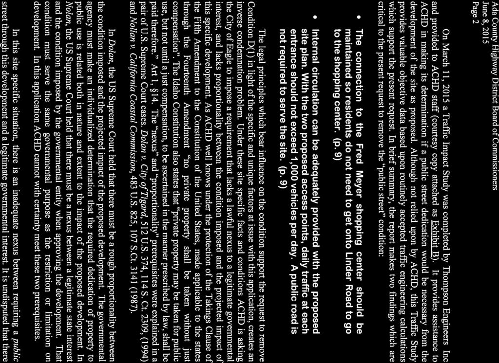
2 Staff disagrees with the applicant s attorney s claim that construction of a public street, as recommended in the staff report, would force a nearly impossible 90 degree turn on each flat bed and semi truck that uses the northern drive isle and then the future public street to access Temple Drive and Linder Road. A 90 degree turn is a very common turning movement for all drivers regardless of vehicle type and can be made by flat bed and semi-trucks. ACHD s Traffic Services staff has reviewed the left turning movement that would occur when a flat bed or semi-truck would turn from the public street within Gated Garden Subdivision (stub street to the site) on to Temple Drive. They found there to be no issues with the turning movements, this is illustrated below, when a semi-truck turning template was overlaid over the applicant s site plan at the intersection of the stub street and Temple Drive. Additionally, Fred Meyers has indicated that most of their delivery vehicles use Chinden Boulevard to access and leave the site. Because of this staff believes that very few delivery vehicles would exit the Fred Myers site via Temple Drive. Temple Drive Stub Street
3 Staff disagrees with the applicant s attorney s claim that the submitted traffic impact study demonstrates that a public street is not needed to serve the site. The traffic impact study prepared by Thompson Engineers was not prepared for ACHD, as noted in Finding of Fact B 2 of the attached staff report, and did not include an analysis of the site with a public street through the site. Staff requested that the traffic study be revised to include an analysis of the site with a public street, however, this analysis was not provided. The traffic study does note that the site will generate approximately 1,122 vehicle trips per day. This is within the threshold of a local public street which is typically no more than 1,000 trips per day on a new local street and 2,000 trips per day when the surrounding area is fully developed. Staff does not believe that the traffic impact study demonstrates that public street is not needed to serve the site, because the traffic impact study did not include an analysis of a public street though the site. The applicant s attorney s letter notes that the ACHD has asked for the stub street to be extended as a collector roadway through the site. This is not true; staff has recommended that a standard 36-foot local street be constructed. Staff also disagrees with the costs to construct the street noted in the letter. The applicant s attorney provided a cost of $425,000 to construct the street. ACHD estimates the cost of the construction of a local street in this location to be approximately $200,000 including design costs and a 10% contingency. This is less than half of what the applicant s attorney presented. The applicant has not demonstrated that is this is a unique situation and that the stub street should not be extended through the site. Staff Recommendation: Staff recommends approval of the staff report, as written; including the recommendation to extend the stub street through the site. Attachments: 1. Letter from Applicant s Attorney 2. Staff Report


4

5


6
7


8


9

10

11
12


13

14

15
16

17

18
19


20
21
22


23

24
25

26

27


28 Development Services Department Project/File: Lead Agency: Site address: Linder Apartments - EAG / CPA-01-15/A-01-15/RZ This is a comprehensive plan and text amendment, annexation, and rezone with development agreement application to change the land use designation of the site from Transitional Residential with a density of 4 units per acre to Mixed Use with a density of 14.9 dwelling units an acre to allow for the development of 166 apartment units on acres. The site is located at 6940 and 6910 N. Linder Road in Eagle, Idaho. For this application ACHD is a recommending body to The City of Eagle. City of Eagle 6940 & 6910 N. Linder Road Commission Hearing: July 1, 2015 Regular Agenda Applicant: John Rennision LR5, LLC PO BOX 1001 Eagle, ID Representative: Shawn Nickel SLN Planning 1589 N. Estancia Place Eagle, ID Staff Contact: A. Findings of Fact Mindy Wallace Phone: mwallace@achdidaho.org 1. Description of Application: The applicant is requesting approval of a comprehensive plan and text amendment, annexation, and rezone with development agreement application to change the land use designation of the site from Transitional Residential with a density of 4 units per acre to Mixed Use with a density of 14.9 dwelling units an acre to allow for the development of 166 apartment units on acres. The applicant s proposal is not consistent with the City of Eagle s Comprehensive Plan. 1 DRAFT Linder Apartments - EAG
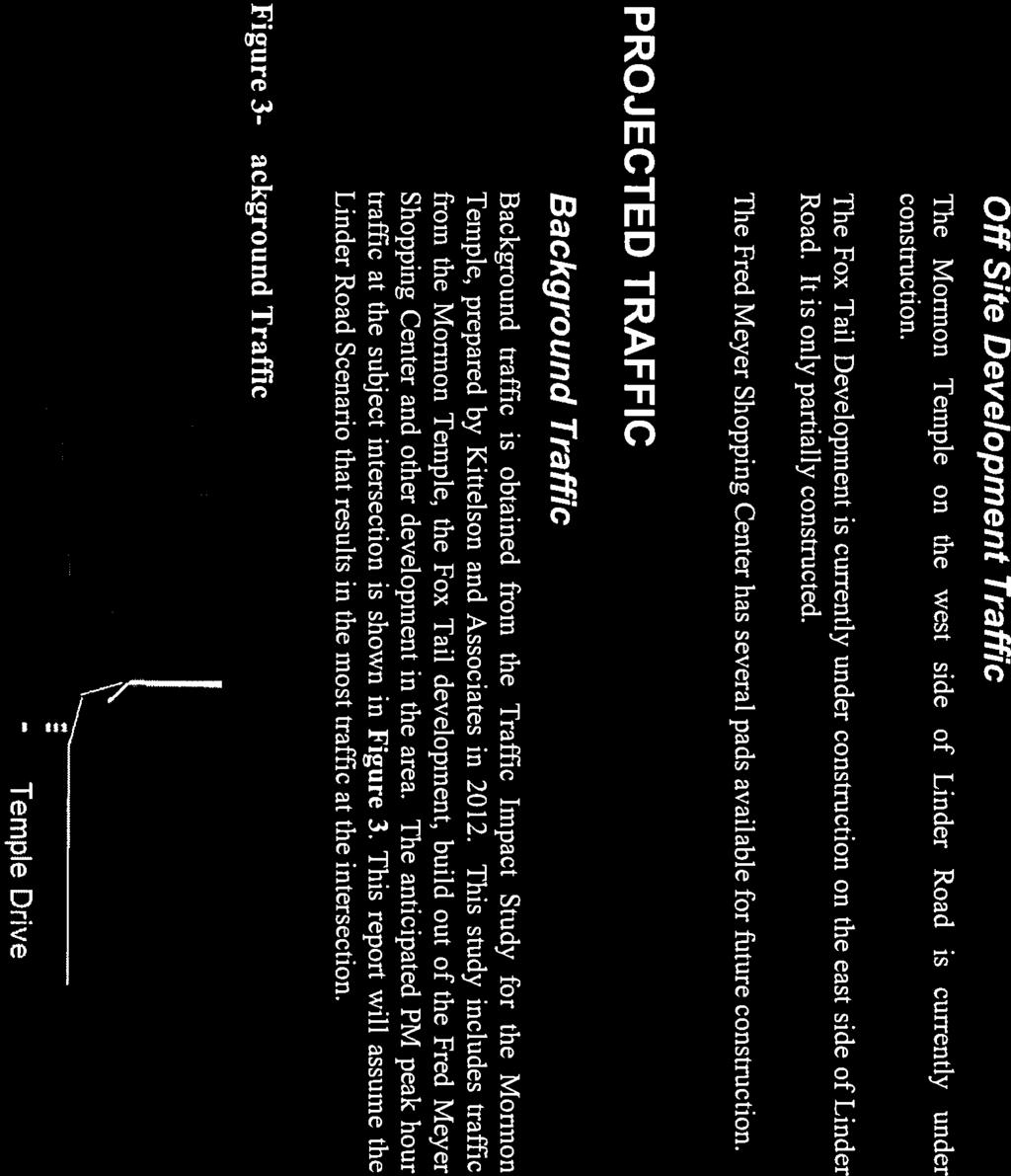
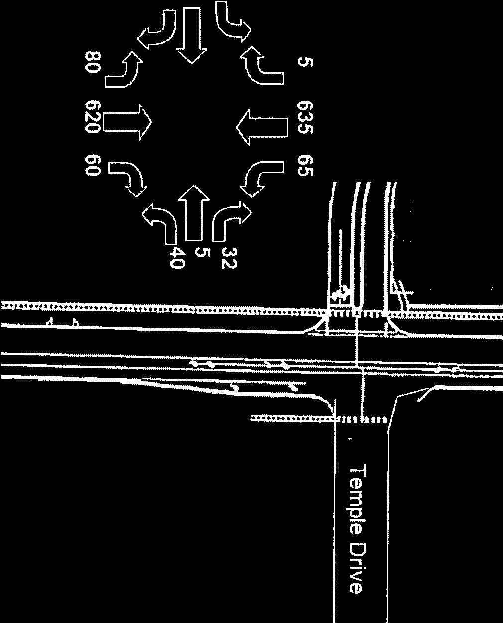
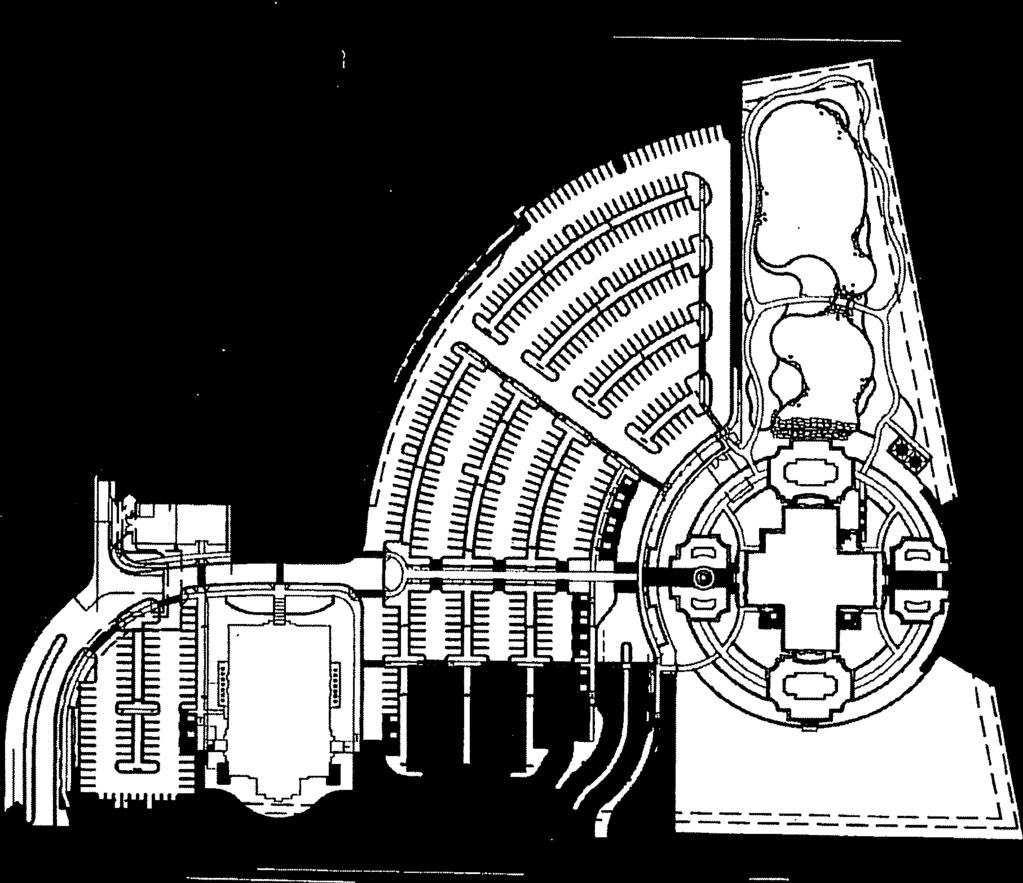
29 2. Description of Adjacent Surrounding Area: Direction Land Use Zoning North Single family residential M-U-DA South Commercial C-3-DA East Single family residential M-U-DA West Single family residential RUT 3. Site History: See Finding for Consideration 1 below. 4. Adjacent Development: The following developments are pending or underway in the vicinity of the site: Application MSP/CU/HD/SN for the Meridian LDS Temple was approved by ACHD on June 26, This project is located across from the site and is currently under construction. Reynard Subdivision consisting of 206 residential lots, 2 commercial lots, and 30 common lots on 80 acres is located directly east of the site is under various stages of development and was approved by ACHD on February 27, Ashbury Subdivision consisting of 214 residential lots, 13 commercial lots, and 19 common lots on 111 acres is located east of the site and was approved by ACHD on June 5, Gated Garden Subdivision consisting of 60 building lots (52 single family and 8 townhome) and 12 common lots on acres is located directly north of the site and was approved by ACHD on August 26, Transit: Transit services are not available to serve this site. 6. Impact Fees: There will be an impact fee that is assessed and due prior to issuance of any building permits. The assessed impact fee will be based on the impact fee ordinance that is in effect at that time. 7. Capital Improvements Plan/ Integrated Five Year Work Plan: There are currently no roadways, bridges or intersections in the general vicinity of the project that are currently in the IFYWP. Linder Road is listed in the CIP to be widened to 7-lanes from Chinden Boulevard/SH-20/26 to State Street/SH-44 between 2017 and The intersection of Chinden Boulevard/SH-20/26 and Linder Road is listed in the CIP to be widened to 8-lanes on the north leg, 8-lanes on the south, 7-lanes on the east, and 7-lanes on the west leg, between 2017and B. Traffic Findings for Consideration 1. Trip Generation: This development is estimated to generate 1,122 additional vehicle trips per day; 102 additional vehicle trips per hour in the PM peak hour, based on the traffic impact study. 2. Traffic Impact Study Thompson Engineers prepared a traffic impact study for the proposed Linder Apartments. The traffic study was prepared for the City of Eagle and is required as part of the applicant s 2 DRAFT Linder Apartments - EAG
30 Comprehesive Plan Amendment application. The submitted traffic impact study was not required by ACHD and was not prepared in accordance with ACHD policy. Below is an executive summary of the findings as presented by Thompson Engineers. The following executive summary is not the opinion of ACHD staff. Executive Summary This report is intended to satisfy the City of Eagle requirements for a traffic impact study when applying for a land use application. In addition to the requirements of the City of Eagle, this report follows the recommendations of the Institute of Transportation Engineers. This report accesses the impact of a 170 unit apartment complex located on Linder Road. Below are the findings of this report. This site can be expected to generate 1,122 vehicle trips daily, with 86 occurring during the AM peak hour and 102 during the PM peak hour. The development complies with the City of Eagle Master Plan and the COMPASS Communities in Motion Plan. The intersection of Linder Road and Temple Drive is not yet constructed but will serve the Mormon Temple and Foxtail Developments currently under construction. Temple Drive is anticipated to be complete this year, in advance of the proposed apartments. The intersection of Linder Road and Temple Drive will operate at an acceptable level of service as a stop control intersection both with and without site traffic. The existing connection to Fred Meyers shopping center should be maintained to allow residents of the apartment complex to access the shopping center without using Linder Road. 3. Condition of Area Roadways Traffic Count is based on Vehicles per hour (VPH) Roadway Linder Road Frontage 860-feet Functional Classification Principal Arterial * Acceptable level of service for a two-lane principal arterial is E (690 VPH). * Acceptable level of service for a four-lane principal arterial is E (1,330 VPH). * Acceptable level of service for a five-lane principal arterial is E (1,770 VPH). 4. Average Daily Traffic Count (VDT) Average daily traffic counts are based on ACHD s most current traffic counts. The average daily traffic count for Linder Road north of Chinden Boulevard was 14,227 on 7/16/14. C. Findings for Consideration PM Peak Hour Traffic Count PM Peak Hour Level of Service Better than D Existing Plus Project Better than D 1. Future Public Street ACHD has been planning for a public street connection through the site to provide access and connectivity between Temple Drive, the east-west collector located north of the site and the Fred Meyer s site. The applicant is opposed to the construction of a public street noting that it does not work with his development plan. Prior to receiving this application, ACHD and City of Eagle staff met with the applicant at least 3 times and discussed the plans for, and benefits of a public street through the site. The applicant was also provided with information regarding prior actions in the DRAFT Linder Apartments - EAG

31 area which reference a public street through the site. Below is a summary of the prior actions, the City of Eagle s Comprehensive Plan, and a discussion of the Continuous Flow Intersection currently being contemplated by the Idaho Transportation Department (ITD) for the Linder/Chinden intersection. Prior Actions: Eagle Island Market Place (EIMP) On September 1, 2010 the ACHD Commission approved the EIMP application which included a 17-lot commercial preliminary plat featuring a Fred Meyers store, Fred Meyer fuel island, and 18 additional pad sites. Several findings in the staff report reference a future connection between the Fred Meyer s site and the future northern collector roadway, which is now known as Temple Drive. This is specifically addressed in Finding for consideration 5 Northern Collector Roadway. When EIMP was approved, the exact alignment of the northern collector was unknown, but this section of the report notes that cross access to the property to the north (the site) should be provided in anticipation of the future northern collector roadway (Temple Drive), and to guarantee access to the roadway once it is built. The EIMP site was designed in consideration with the future roadway network. Finding for consideration 8 discusses driveways and access to the Fred Meyer s site and requires the closure of the northerly Fred Meyer s driveway when the northern collector roadway (Temple Drive ) is constructed and public street access is available through the site. In anticipation of a public street connection between the Fred Meyer s and the Temple Drive, a cross access was granted and a driveway approach was constructed from the Fred Meyer s to the sites south property line. Additionally, the applicant of EIMP entered into a development agreement with ACHD to ensure the closer of the northern driveway, and provided a financial surety to pay for the closure of the driveway and associated landscaping. SITE Driveway approach with cross access easement Driveway to be closed 4 DRAFT Linder Apartments - EAG

32 CPA On August 25, 2015 staff issued a comment letter on CPA-02-14, a comprehensive plan amendment application which included this site that is under review. ACHD provided specific comments regarding a future public street connection through the site. The letter reads, To ensure that alternative access to Linder Road is available when the Beagley and Eells parcels develop in the future, staff recommended that cross access to the Eells parcel as part of ACHD s action on the Eagle Island Market Place application. The cross access was recommended with the idea of creating a north/south backage road between the Fred Meyer site and the new collector, Temple Drive, proposed to be constructed through the Bodily-Bunderson parcels as part of Gated Garden Subdivision. The applicant of the Gated Garden Subdivision has proposed to construct the first segment of the north/south backage road stubbing it to the north property line of the Beagley property. This road should be extended through the Beagley and Eells parcels connecting into the northern drive aisle of the Fred Meyer Store as the parcels redevelop in the future eliminating the need for direct lot access onto Linder Road. Approximate location of Temple Drive Beagley Gated Garden Eells 5 DRAFT Linder Apartments - EAG

33 Gated Garden Subdivision On August 26, 2014 Gated Garden Subdivision was approved with a public street stubbed to the site s north property line. This stub street begins the public street connection between Temple Drive and the Fred Meyer s drive aisle. ACHD policy requires that approved stub street to be extended through this site. Public stub street to the site City of Eagle s Comprehensive Plan As noted above ACHD acted on a comprehensive plan amendment (CPA-02-14) for this site on August 25, On December 16, 2014 the Eagle City Council approved the CPA application increasing the density of the site from 2 to 4 units per acre and making changes to the text portion of the Rim View Planning Area of the City s comprehensive plan. A public street connection between Temple Drive and the Fred Meyer s site is consistent with the City of Eagle s Comprehensive Plan and the Rim View Planning Area portion of the planning that it would meet the following goals of the comprehensive plan: The Eagle Comprehensive Plan Chapter Transportation: Specific Design Strategies states: a. Support the access restriction policies of the Ada County Highway District. b. Limit access to all arterial streets. c. Discourage direct lot access to parcels abutting arterial and collector streets. 6 DRAFT Linder Apartments - EAG
34 d. Develop methods, such as cross-access agreements, frontage and backage roads, to reduce the number of existing access points onto arterial streets. e. Encourage planning of local roadway systems that will provide for intra-neighborhood connectivity. The connecting roadways should be designed to not become collectors and to discourage traffic from cutting through neighborhoods to go from a collector or arterial to another collector or arterial. Such intra-neighborhood connectivity is for emergency and delivery vehicles and for local intra-neighborhood access The Eagle Comprehensive Plan Rim View Planning Area section B: Access states: 1. Access to the area should focus on new internal linkages that allow adjacent parcels to provide pedestrian and vehicle connectivity into the Rim View Planning Area. 2. Primary access should be from a new residential collector connecting Linder Road to Meridian Road with limited access onto Chinden Boulevard only in accordance with ITD s access management policies. All accesses should be designed to allow traffic to flow through the area connecting Meridian Road to Linder Road may provide the opportunity of future east/west residential collector linkage within the planning area. Cross-access and local stub streets should be used to allow the planning area to be interconnected without the need to access the arterial and state highway network. 3. Internal and interconnected circulation should be used to move traffic within the nonresidential area, helping to mitigate the number of local vehicle trips entering State Highway 20/26 and Linder Road to access commercial and mixed use services and create cross access into adjoining properties. 4. Chinden Boulevard and Linder Road should be recognized as a gateway corridor to the City of Eagle and development should adhere to proper berming, landscaping, and appropriate setbacks to prevent the encroachment of abutting uses into future corridor improvements. This would protect the viability of the regional transportation corridor as well as buffer the abutting uses from the impacts of the corridor. With the recent action and increased density on the site, the City of Eagle staff has indicated that they are not supportive of the densities proposed by the applicant and that the applicant s proposal is not consistent with the land uses within the comprehensive plan adopted in January of During pre-application meetings with the applicant the City staff has stated that there are better options for the site that better fit the transportation needs of the area. One possible option suggested by the City would be to front offices or mini-storage along Linder Road and use the public street as a buffer with residential units east of the roadway. This proposal removes the City s requirements for a 75-foot wide landscape buffer along Linder Road and would allow better utilization of the residential portion of the site. The City of Eagle would be supportive of this or a similar proposal. US 20/26-Chinden Boulevard Corridor Preservation Study (Caldwell to Eagle Road) The Idaho Transportation Department (ITD) is studying U.S. 20/26-Chinden Boulevard from Aviation Way in Caldwell to Eagle Road in Boise. This study is called the U.S. 20/26 Corridor Preservation Study. The corridor study is being conducted to identify the transportation improvements needed to preserve the corridor in order to accommodate future traffic demands. U.S. 20/26-Chinden Boulevard is one of a few east-west roadways that stretch from Caldwell to Boise and it is an important commuter route in the Treasure Valley. In 2005, ITD began this study 7 DRAFT Linder Apartments - EAG
35 in partnership with the Community Planning Association of Southwest Idaho (COMPASS) to plan improvements to this corridor. Land adjacent to the roadway is being developed and the future is expected to bring mixed-use development that will transform U.S. 20/26 from a rural roadway into a busy urban corridor. ITD is working with local governments, highway districts and the public to develop the roadway design for this corridor. Based on input and analysis throughout the project, ITD proposes to widen and improve the entire corridor from Aviation Way in Caldwell to Eagle Road in Boise. The roadway s future design considerations include: Widening U.S. 20/26 to four or six lanes depending on the location. Making the entire roadway a divided highway with a median in select areas. Improving intersections and cross streets (i.e. add turn lanes, signals, and/or pedestrian ramps, etc.) Adding bicycle and pedestrian facilities along the roadway. As part of the US 20/26-Chinden Boulevard Corridor Preservation Study ITD is evaluating a potential continuous flow intersection at the Linder/Chinden intersection. This would eliminate all left turning movements in and out of the Eagle Island Market Place located south of the site and would restrict residential developments located east of the site with access to US 20/26-Chinden Boulevard to right-in-right-out only. These potential restrictions make the future public street connection through this site between Temple Drive and Fred Meyer s necessary to allow the traveling public to make left turns at the Temple Drive/Linder Road intersection which is anticipated to be signalized in the future, to provide connectivity between the residential neighborhoods located north and east of the site and the Fred Meyer s site south of the site, and to reduce trips on the arterial roadway system. Staff Comments/Recommendations: Consistent with ACHD s prior actions on this site and adjacent to the site, the City of Eagle s Comprehensive Plan, and ACHD s Continuation of Streets policy which requires stub streets to be extended, staff recommends that the applicant be required to construct a public street through the site tying in to the Fred Meyer s drive aisle, as has been planned. The new public street provides a public benefit by providing connectivity and reducing vehicle trips on the arterial and state high system. The new public street should be constructed as a 36-foot street section with vertical curb, gutter, and a 5-foot wide concrete sidewalk within 50-feet of right-of-way. The right-of-way width can be reduced if detached sidewalks are constructed. 2. Northwest Foothills Transportation Plan - Update The Northwest Foothills Transportation Plan (NWFTP) was adopted in December 2008 with the understanding that if land use projections changed dramatically, amendments to the plan could be required. As a result, the Ada County Highway District and the City of Eagle began an update of the Study in February The purpose of the update is to analyze traffic operations and identify improvements needed within the study area. The results will be an addendum to the current study that will focus on the key items that changed as a result of this update. The Study will continue to function as a policy guide and corridor preservation mechanism for improving the transportation system as development occurs and offer strategies for roadway and intersection improvements based on new 2035 demographics. The NWFTP Update was before the ACHD Commission for adoption on July 24, 2013 and on January 22, After hearing testimony from staff, area property owners, and receiving a letter from the City of Eagle requesting that ACHD defer taking an action on the NWFTP Update 8 DRAFT Linder Apartments - EAG
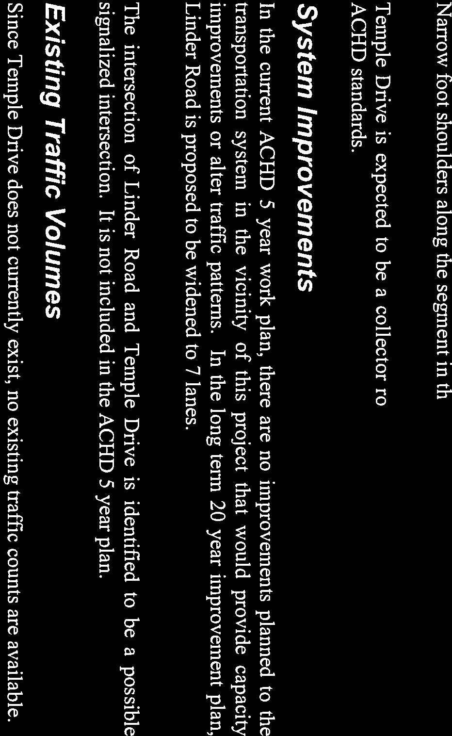
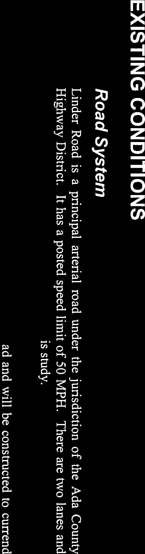
36 for one year to allow the City to reevaluate their land uses in the NWFTP planning area, the Commission voted to defer taking an action on the NWFTP Update. The NWFTP is currently on hold pending Commission direction. 3. Linder Road a. Existing Conditions: Linder Road is improved with 2-travel lanes, 33-feet of pavement, and no curb, gutter or sidewalk abutting the site. There is 62 to 66-feet of right-of-way for Linder Road abutting the site (25-32-feet from centerline). b. Policy: Arterial Roadway Policy: District Policy states that the developer is responsible for improving all street frontages adjacent to the site regardless of whether or not access is taken to all of the adjacent streets. Master Street Map and Typology Policy: District Policy states that the design of improvements for arterials shall be in accordance with District standards, including the Master Street Map and Livable Streets Design Guide. The developer or engineer should contact the District before starting any design. Street Section and Right-of-Way Width Policy: District Policies & state that the standard 7-lane street section shall be 96-feet (back-of-curb to back-of-curb) within 120-feet of right-of-way. This width typically accommodates three travel lanes in each direction, a continuous raised or landscaped median with intermittent turn lanes, and safety shoulders. Right-of-Way Dedication: District Policy states that The District will provide compensation for additional right-of-way dedicated beyond the existing right-of-way along arterials listed as impact fee eligible in the adopted Capital Improvements Plan using available impact fee revenue in the Impact Fee Service Area. No compensation will be provided for right-of-way on an arterial that is not listed as impact fee eligible in the Capital Improvements Plan. The District may acquire additional right-of-way beyond the site-related needs to preserve a corridor for future capacity improvements, as provided in Section Sidewalk Policy: District Policy requires a concrete sidewalk at least 5-feet wide to be constructed on both sides of all arterial streets. A parkway strip at least 6-feet wide between the back-of-curb and street edge of the sidewalk is required to provide increased safety and protection of pedestrians. Consult the District s planter width policy if trees are to be placed within the parkway strip. Sidewalks constructed next to the back-of-curb shall be a minimum of 7-feet wide. Detached sidewalks are encouraged and should be parallel to the adjacent roadway. Meandering sidewalks are discouraged. A permanent right-of-way easement shall be provided if public sidewalks are placed outside of the dedicated right-of-way. The easement shall encompass the entire area between the rightof-way line and 2-feet behind the back edge of the sidewalk. Sidewalks shall either be located wholly within the public right-of-way or wholly within an easement. ACHD Master Street Map: ACHD Policy Section requires the Master Street Map (MSM) guide the right-of-way acquisition, arterial street requirements, and specific roadway features required through development. This segment of Linder Road is designated in the MSM as a Residential/Mobility Arterial with 7 lanes and on-street bike lanes, a foot street section within feet of right-of-way. c. Applicant Proposal: The applicant is proposing to construct a detached concrete sidewalk on Linder Road abutting the site. 9 DRAFT Linder Apartments - EAG
37 d. Staff Comments/Recommendations: Consistent with the MSM the applicant should be required to dedicate 62-feet from the centerline of Linder Road abutting the site. The applicant should be required to construct a 5-foot wide detached concrete sidewalk located 55-feet from the centerline of Linder Road abutting the site. 4. Stub Street a. Existing Conditions: A public stub street to the site s north property line will be constructed as part of Gated Garden Subdivision. b. Policy: Stub Street Policy: District policy states that stub streets will be required to provide circulation or to provide access to adjoining properties. Stub streets will conform with the requirements described in Section , except a temporary cul-de-sac will not be required if the stub street has a length no greater than 150-feet. A sign shall be installed at the terminus of the stub street stating that, "THIS ROAD WILL BE EXTENDED IN THE FUTURE. In addition, stub streets must meet the following conditions: A stub street shall be designed to slope towards the nearest street intersection within the proposed development and drain surface water towards that intersection; unless an alternative storm drain system is approved by the District. The District may require appropriate covenants guaranteeing that the stub street will remain free of obstructions. Continuation of Streets Policy: District Policy states that an existing street, or a street in an approved preliminary plat, which ends at a boundary of a proposed development shall be extended in that development. The extension shall include provisions for continuation of storm drainage facilities. Benefits of connectivity include but are not limited to the following: Reduces vehicle miles traveled. Increases pedestrian and bicycle connectivity. Increases access for emergency services. Reduces need for additional access points to the arterial street system Promotes the efficient delivery of services including trash, mail and deliveries. Promotes appropriate intra-neighborhood traffic circulation to schools, parks, neighborhood commercial centers, transit stops, etc. Promotes orderly development. c. Applicant Proposal: The applicant has proposed to extend a private drive aisle off the stub street to serve the site. d. Staff Comments/Recommendations: The applicant s proposal does not meet District policy and should not be approved, as proposed. The applicant should be required to extend the stub street south through the site as a public street connecting to the Fred Meyers drive aisle as noted in Finding for Consideration Tree Planters Tree Planter Policy: Tree Planter Policy: The District s Tree Planter Policy prohibits all trees in planters less than 8-feet in width without the installation of root barriers. Class II trees may be allowed in planters with a minimum width of 8-feet, and Class I and Class III trees may be allowed in planters with a minimum width of 10-feet. 10 DRAFT Linder Apartments - EAG
38 6. Landscaping Landscaping Policy: A license agreement is required for all landscaping proposed within ACHD right-of-way or easement areas. Trees shall be located no closer than 10-feet from all public storm drain facilities. Landscaping should be designed to eliminate site obstructions in the vision triangle at intersections. District Policy requires a 40-foot vision triangle and a 3-foot height restriction on all landscaping located at an uncontrolled intersection and a 50-foot offset from stop signs. Landscape plans are required with the submittal of civil plans and must meet all District requirements prior to signature of the final plat and/or approval of the civil plans. 7. Other Access Linder Road is classified as a principal arterial roadway. Direct lot access to Linder Road is not proposed and is prohibited. D. Site Specific Conditions of Approval 1. Extend the stub street from Gated Garden Subdivision through the site as a public street tying into the driveway approach for the Fred Meyer s drive aisle as a 36-foot street section with vertical curb, gutter, and 5-foot wide concrete sidewalk within 50-feet of right-of-way. The right-of-way width may be reduced if detached sidewalks are constructed and placed within an easement. 2. Dedicate 62-feet of right-of-way from the centerline of Linder Road abutting the site. The right-ofway purchase and sale agreement and deed must be completed and signed by the applicant prior to scheduling the final plat for signature by the ACHD Commission or prior to issuance of a building permit (or other required permits), whichever occurs first. Allow up to 30 business days to process the right-of-way dedication after receipt of all requested material. The District will purchase the right-of-way which is in addition to existing right-of-way from available Corridor Preservation Funds. 3. Construct a 5-foot wide detached concrete sidewalk located 55-feet from the centerline of Linder Road abutting the site. 4. Provide a permanent right-of-way easement for any detached sidewalks located outside of the dedicated right-of-way. 5. Direct lot access to Linder Road is prohibited. 6. Payment of impacts fees are due prior to issuance of a building permit. 7. Comply with all Standard Conditions of Approval. E. Standard Conditions of Approval 1. All proposed irrigation facilities shall be located outside of the ACHD right-of-way (including all easements). Any existing irrigation facilities shall be relocated outside of the ACHD rightof-way (including all easements). 2. Private Utilities including sewer or water systems are prohibited from being located within the ACHD right-of-way. 3. In accordance with District policy, , the applicant may be required to update any existing non-compliant pedestrian improvements abutting the site to meet current Americans with Disabilities Act (ADA) requirements. The applicant s engineer should provide documentation of ADA compliance to District Development Review staff for review. 4. Replace any existing damaged curb, gutter and sidewalk and any that may be damaged during the construction of the proposed development. Contact Construction Services at (with file number) for details. 11 DRAFT Linder Apartments - EAG
39 5. A license agreement and compliance with the District s Tree Planter policy is required for all landscaping proposed within ACHD right-of-way or easement areas. 6. All utility relocation costs associated with improving street frontages abutting the site shall be borne by the developer. 7. It is the responsibility of the applicant to verify all existing utilities within the right-of-way. The applicant at no cost to ACHD shall repair existing utilities damaged by the applicant. The applicant shall be required to call DIGLINE ( ) at least two full business days prior to breaking ground within ACHD right-of-way. The applicant shall contact ACHD Traffic Operations in the event any ACHD conduits (spare or filled) are compromised during any phase of construction. 8. Utility street cuts in pavement less than five years old are not allowed unless approved in writing by the District. Contact the District s Utility Coordinator at (with file numbers) for details. 9. All design and construction shall be in accordance with the ACHD Policy Manual, ISPWC Standards and approved supplements, Construction Services procedures and all applicable ACHD Standards unless specifically waived herein. An engineer registered in the State of Idaho shall prepare and certify all improvement plans. 10. Construction, use and property development shall be in conformance with all applicable requirements of ACHD prior to District approval for occupancy. 11. No change in the terms and conditions of this approval shall be valid unless they are in writing and signed by the applicant or the applicant s authorized representative and an authorized representative of ACHD. The burden shall be upon the applicant to obtain written confirmation of any change from ACHD. 12. If the site plan or use should change in the future, ACHD Planning Review will review the site plan and may require additional improvements to the transportation system at that time. Any change in the planned use of the property which is the subject of this application, shall require the applicant to comply with ACHD Policy and Standard Conditions of Approval in place at that time unless a waiver/variance of the requirements or other legal relief is granted by the ACHD Commission. F. Conclusions of Law 1. The proposed site plan is approved, if all of the Site Specific and Standard Conditions of Approval are satisfied. 2. ACHD requirements are intended to assure that the proposed use/development will not place an undue burden on the existing vehicular transportation system within the vicinity impacted by the proposed development. G. Attachments 1. Vicinity Map 2. Site Plan 3. Utility Coordinating Council 4. Development Process Checklist 5. Request for Reconsideration Guidelines 12 DRAFT Linder Apartments - EAG

40 VICINITY MAP 13 DRAFT Linder Apartments - EAG

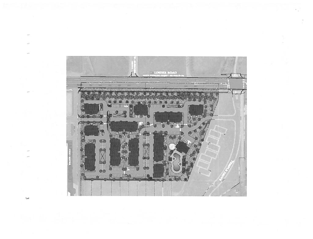
41 SITE PLAN 14 DRAFT Linder Apartments - EAG
42 Ada County Utility Coordinating Council Developer/Local Improvement District Right of Way Improvements Guideline Request Purpose: To develop the necessary avenue for proper notification to utilities of local highway and road improvements, to help the utilities in budgeting and to clarify the already existing process. 1) Notification: Within five (5) working days upon notification of required right of way improvements by Highway entities, developers shall provide written notification to the affected utility owners and the Ada County Utility Coordinating Council (UCC). Notification shall include but not be limited to, project limits, scope of roadway improvements/project, anticipated construction dates, and any portions critical to the right of way improvements and coordination of utilities. 2) Plan Review: The developer shall provide the highway entities and all utility owners with preliminary project plans and schedule a plan review conference. Depending on the scale of utility improvements, a plan review conference may not be necessary, as determined by the utility owners. Conference notification shall also be sent to the UCC. During the review meeting the developer shall notify utilities of the status of right of way/easement acquisition necessary for their project. At the plan review conference each company shall have the right to appeal, adjust and/or negotiate with the developer on its own behalf. Each utility shall provide the developer with a letter of review indicating the costs and time required for relocation of its facilities. Said letter of review is to be provided within thirty calendar days after the date of the plan review conference. 3) Revisions: The developer is responsible to provide utilities with any revisions to preliminary plans. Utilities may request an updated plan review meeting if revisions are made in the preliminary plans which affect the utility relocation requirements. Utilities shall have thirty days after receiving the revisions to review and comment thereon. 4) Final Notification: The developer will provide highway entities, utility owners and the UCC with final notification of its intent to proceed with right of way improvements and include the anticipated date work will commence. This notification shall indicate that the work to be performed shall be pursuant to final approved plans by the highway entity. The developer shall schedule a preconstruction meeting prior to right of way improvements. Utility relocation activity shall be completed within the times established during the preconstruction meeting, unless otherwise agreed upon. Notification to the Ada County UCC can be sent to: 50 S. Cole Rd. Boise 83707, or Visit iducc.com for notification information. 15 DRAFT Linder Apartments - EAG
43 Development Process Checklist Items Completed to Date: Submit a development application to a City or to Ada County The City or the County will transmit the development application to ACHD The ACHD Planning Review Section will receive the development application to review The Planning Review Section will do one of the following: Send a No Review letter to the applicant stating that there are no site specific conditions of approval at this time. Write a Staff Level report analyzing the impacts of the development on the transportation system and evaluating the proposal for its conformance to District Policy. Write a Commission Level report analyzing the impacts of the development on the transportation system and evaluating the proposal for its conformance to District Policy. Items to be completed by Applicant: For ALL development applications, including those receiving a No Review letter: The applicant should submit one set of engineered plans directly to ACHD for review by the Development Review Section for plan review and assessment of impact fees. (Note: if there are no site improvements required by ACHD, then architectural plans may be submitted for purposes of impact fee assessment.) The applicant is required to get a permit from Construction Services (ACHD) for ANY work in the right-ofway, including, but not limited to, driveway approaches, street improvements and utility cuts. Pay Impact Fees prior to issuance of building permit. Impact fees cannot be paid prior to plan review approval. DID YOU REMEMBER: Construction (Non-Subdivisions) Driveway or Property Approach(s) Submit a Driveway Approach Request form to ACHD Construction (for approval by Development Services & Traffic Services). There is a one week turnaround for this approval. Working in the ACHD Right-of-Way Four business days prior to starting work have a bonded contractor submit a Temporary Highway Use Permit Application to ACHD Construction Permits along with: a) Traffic Control Plan b) An Erosion & Sediment Control Narrative & Plat, done by a Certified Plan Designer, if trench is >50 or you are placing >600 sf of concrete or asphalt. Construction (Subdivisions) Sediment & Erosion Submittal At least one week prior to setting up a Pre-Construction Meeting an Erosion & Sediment Control Narrative & Plan, done by a Certified Plan Designer, must be turned into ACHD Construction to be reviewed and approved by the ACHD Stormwater Section. Idaho Power Company Vic Steelman at Idaho Power must have his IPCO approved set of subdivision utility plans prior to Pre-Con being scheduled. Final Approval from Development Services is required prior to scheduling a Pre-Con. 16 DRAFT Linder Apartments - EAG
44 Request for Reconsideration of Commission Action 1. Request for Reconsideration of Commission Action: A Commissioner, a member of ACHD staff or any other person objecting to any final action taken by the Commission may request reconsideration of that action, provided the request is not for a reconsideration of an action previously requested to be reconsidered, an action whose provisions have been partly and materially carried out, or an action that has created a contractual relationship with third parties. a. Only a Commission member who voted with the prevailing side can move for reconsideration, but the motion may be seconded by any Commissioner and is voted on by all Commissioners present. If a motion to reconsider is made and seconded it is subject to a motion to postpone to a certain time. b. The request must be in writing and delivered to the Secretary of the Highway District no later than 3:00 p.m. on the day prior to the Commission s next scheduled regular meeting following the meeting at which the action to be reconsidered was taken. Upon receipt of the request, the Secretary shall cause the same to be placed on the agenda for that next scheduled regular Commission meeting. c. The request for reconsideration must be supported by written documentation setting forth new facts and information not presented at the earlier meeting, or a changed situation that has developed since the taking of the earlier vote, or information establishing an error of fact or law in the earlier action. The request may also be supported by oral testimony at the meeting. d. If a motion to reconsider passes, the effect is the original matter is in the exact position it occupied the moment before it was voted on originally. It will normally be returned to ACHD staff for further review. The Commission may set the date of the meeting at which the matter is to be returned. The Commission shall only take action on the original matter at a meeting where the agenda notice so provides. e. At the meeting where the original matter is again on the agenda for Commission action, interested persons and ACHD staff may present such written and oral testimony as the President of the Commission determines to be appropriate, and the Commission may take any action the majority of the Commission deems advisable. f. If a motion to reconsider passes, the applicant may be charged a reasonable fee, to cover administrative costs, as established by the Commission. 17 DRAFT Linder Apartments - EAG
May 21, ACHD Board of Commissioners Stacey Yarrington, Planner II DRH /DRH
 Development Services Department May 21, 2013 TO: FROM: SUBJECT: ACHD Board of Commissioners Stacey Yarrington, Planner II DRH13-00106/DRH13-00108 Executive Summary: This is a design review application
Committed to Service
 Committed to Service Paul Woods, President Rebecca W. Arnold, Vice President Sara M. Baker, Commissioner Jim D. Hansen, Commissioner Kent Goldthorpe, Commissioner August 25, 2017 Development Services TO:
Executive Summary: This is a preliminary plat to construct 8 residential lots and 2 commons lots with a private road on 3.87-acres in Meridian, Idaho.
 Development Services Department DATE: July 7, 2015 TO: FROM: SUBJECT: ACHD Board of Commissioners Stacey Yarrington, Planner III Kentucky Villas/ MPP15-0012/ PP15-009 Executive Summary: This is a preliminary
SUB /CAR /PUD
 Development Services Department Project/File: Lead Agency: Site address: Balntyre Court Subdivision/BPP16-0036/ SUB16-00066/CAR16-00035/PUD16-00040 This is a rezone, planned unit development, and subdivision
Date: March 16, Jake Centers ERD, LLC P.O. Box 1610 Eagle, ID Elevation Ridge Subdivision (SUB & PUD ) Street Address
 Street Address") Rebecca W. Arnold, President Sara M. Baker, Vice President John S. Franden, Commissioner Carol A. McKee, Commissioner David L. Case, Commissioner Date: March 16, 2012 To: Jake Centers ERD, LLC P.O. Box
Rebecca W. Arnold, President Sara M. Baker, Vice President John S. Franden, Commissioner Carol A. McKee, Commissioner David L. Case, Commissioner Date: March 16, 2012 To: Jake Centers ERD, LLC P.O. Box
Committed to Service
 Committed to Service Kent Goldthorpe, President Paul Woods, Vice President Rebecca W. Arnold, Commissioner Sara M. Baker, Commissioner Jim D. Hansen, Commissioner July 18, 2016 Development Services TO:
Committed to Service
 Committed to Service Sara M. Baker, President Rebecca W. Arnold, Vice President Jim D. Hansen, Commissioner Kent Goldthorpe, Commissioner Paul Woods, Commissioner January 16, 2018 Development Services
#1 (CAR /SUB )
") Development Services Department Project/File: Lead Agency: Site address: Fork South #1 (CAR14-00009/SUB14-00024) The applicant is requesting annexation, rezone and preliminary plat approvals for a 52-lot
Development Services Department Project/File: Lead Agency: Site address: Fork South #1 (CAR14-00009/SUB14-00024) The applicant is requesting annexation, rezone and preliminary plat approvals for a 52-lot
3. The preliminary plats were approved on March 27, 2014 and August 14, 2014.
 Jim D. Hansen, President Sara M. Baker, Vice President Rebecca W. Arnold, Commissioner Kent Goldthorpe, Commissioner Paul Woods, Commissioner February 12, 2015 Development Services Department To: From:
If you have any questions, please feel free to contact me at (208)
") Sara M. Baker, President John S. Franden, Vice President Rebecca W. Arnold, Commissioner Mitchell A. Jaurena, Commissioner Jim Hansen, Commissioner Date: March 21, 2013 To: Subject: Hornet Construction
Sara M. Baker, President John S. Franden, Vice President Rebecca W. Arnold, Commissioner Mitchell A. Jaurena, Commissioner Jim Hansen, Commissioner Date: March 21, 2013 To: Subject: Hornet Construction
Date: August 29, Dave Scaggs (sent via ) Summit Development Inc th Ave. Rd. #384 Nampa, ID 83686
 Summit Development Inc th Ave. Rd. #384 Nampa, ID 83686") Sara M. Baker, President John S. Franden, Vice President Rebecca W. Arnold, Commissioner Mitchell A. Jaurena, Commissioner Jim Hansen, Commissioner Date: August 29, 2013 To: Dave Scaggs (sent via email)
Sara M. Baker, President John S. Franden, Vice President Rebecca W. Arnold, Commissioner Mitchell A. Jaurena, Commissioner Jim Hansen, Commissioner Date: August 29, 2013 To: Dave Scaggs (sent via email)
BOI / DRH Albertsons grocery market and fueling center & pad sites
 Paul Woods, President Rebecca W. Arnold, Vice President Sara M. Baker, Commissioner Jim D. Hansen, Commissioner Kent Goldthorpe, Commissioner March 28, 2017 To: Mark Palmer Albertsons Companies 250 E.
Right-of-Way & Development Services Planning Review Division Committed to Service This application is approved at the staff level on February 1, 2006.
 Right-of-Way & Development Services Planning Review Division Committed to Service This application is approved at the staff level on February 1, 2006. Tech Review for this item was held with the applicant
Committed to Service
 Committed to Service Sara M. Baker, President Rebecca W. Arnold, Vice President Jim D. Hansen, Commissioner Kent Goldthorpe, Commissioner Paul Woods, Commissioner February 28, 2018 Development Services
SECTION 7000 LAND DEVELOPMENT REQUIREMENTS
 SECTION 7000 LAND DEVELOPMENT REQUIREMENTS 7000 LAND DEVELOPMENT REQUIREMENTS... 1 7001 LEGISLATIVE AUTHORITY... 1 7001.1 LAND DEVELOPMENT... 1 7001.1.1 Title 40, Idaho Code... 1 7001.1.2 Idaho Code 40-1415
Subdivision Staff Report
 Subdivision Staff Report Subdivision Name Toli Park Subdivision File Number SUB07-00035 Approval Preliminary Plat Lead Agency Boise City Annexation Date December 30, 1987 Comp. Plan Complies Public Hearing
Subdivision Staff Report
 Subdivision Staff Report Subdivision Name Coldstream File Number SUB06-00040 Subdivision Approval Preliminary Plat Lead Agency Boise City Annexation Date December 9, 1974 Comp. Plan Complies Public Hearing
Subdivision Staff Report
 Subdivision Staff Report Subdivision Name Sunnyridge Subdivision File Number SUB07-00007 Approval Preliminary Plat Lead Agency Ada County Annexation Date NA Comp. Plan Complies (With Conditions of Approval)
Subdivision Staff Report
 Subdivision Staff Report Subdivision Name Honeymoon Cove Subdivision File Number SUB08-00005 Approval Preliminary/ Final Plat Lead Agency Boise City Annexation Date December 30, 2004 Comp. Plan Complies
Draft Model Access Management Overlay Ordinance
 Draft Model Access Management Overlay Ordinance This model was developed using the City of Hutchinson and the Trunk Highway 7 corridor. The basic provisions of this model may be adopted by any jurisdiction
M-43 CORRIDOR OVERLAY ZONE
 ARTICLE 26.00 M-43 CORRIDOR OVERLAY ZONE Section 26.01 Findings A primary function of the M-43 state highway is to move traffic through the Township and to points beyond. As the primary east-west arterial
SUB / Diamante Subdivision / Northside Management
 SU15-00062 / Diamante Subdivision / Northside Management Summary: Subdivision application for a Preliminary Plat consisting of 20 buildable lots and 3 common lots. Prepared y: Todd Tucker, Senior Planner
Let me know if I need to bring you any other documentation for this withdrawl. Thanks!
 >>> david benoit 11/27/2007 10:00 AM >>> Dave, I am set to be heard on the Cranston Corner Subdivision on December 4th in front of City council. I have sold this property and am requesting
a. provide for the continuation of collector streets and thoroughfare streets between adjacent subdivisions;
 Section 7.07. Intent The requirements of this Section are intended to provide for the orderly growth of the Town of Holly Springs and its extra-territorial jurisdiction by establishing guidelines for:
Time Extension Staff Report
 Time Extension Staff Report Subdivision Name Lunara Subdivision File Number SUB07-00019 Approval Time Extension for Lead Agency Boise City Certification Signature of Boise City Engineer Annexation Date
ZONING AMENDMENT, PLANNED UNIT DEVELOPMENT & SUBDIVISION STAFF REPORT Date: August 8, 2013
 ZONING AMENDMENT, PLANNED UNIT DEVELOPMENT & SUBDIVISION STAFF REPORT Date: August 8, 2013 NAME SUBDIVISION NAME PV-Magnolia, LLC Twelve Trees Subdivision LOCATION 2860, 2862 and 2866 Pleasant Valley Road
9. REZONING NO Vicinity of the northwest corner of 143 rd Street and Metcalf Avenue
 9. REZONING NO. 2002-15 Vicinity of the northwest corner of 143 rd Street and Metcalf Avenue 1. APPLICANT: Andrew Schlagel is the applicant for this request. 2. REQUESTED ACTION: The applicant is requesting
Committed to Service. License Agreement Application Form
 Committed to Service License Agreement Application Form PLEASE NOTE: Effective February 16, 2010 - License Agreements within the downtown Boise area for public structures, objects and uses on ACHD sidewalks
Chapter Plat Design (LMC)
") Chapter 18.14 Plat Design (LMC) Sections: 18.14.010 Lot width 18.14.020 Right-of-way requirements 18.14.030 Pipe stem lots 18.14.040 Division resulting in minimum lot sizes 18.14.050 Flood prone and bad
Chapter 18.14 Plat Design (LMC) Sections: 18.14.010 Lot width 18.14.020 Right-of-way requirements 18.14.030 Pipe stem lots 18.14.040 Division resulting in minimum lot sizes 18.14.050 Flood prone and bad
Time Extension Staff Report
 Time Extension Staff Report Subdivision Name Therrin Subdivision File Number SUB06-00020 Approval Time Extension for Lead Agency Boise City Certification Signature of Boise City Engineer Annexation Date
ARTICLE IV: DEVELOPMENT STANDARDS
 ARTICLE IV: DEVELOPMENT STANDARDS IV-53 409 PRIVATE STREETS A private street means any way that provides ingress to, or egress from, property by means of vehicles or other means, or that provides travel
BYRON TOWNSHIP ZONING APPLICATION
 BYRON TOWNSHIP ZONING APPLICATION Phone: (616) 878-9104 * Fax: (616) 878-3980 * Website: www.byrontownship.org This application will not be accepted if incomplete. APPLICATION FOR & REQUIRED COPIES Private
DAUPHIN CREEK ESTATES SUBDIVISION
 # 12 SUB-000076-2017 DAUPHIN CREEK ESTATES SUBDIVISION Engineering Comments: FINAL PLAT COMMENTS (should be addressed prior to submitting the FINAL PLAT for review and/or signature by the City Engineer):
Section 1: US 19 Overlay District
 Section 1: US 19 Overlay District Section 1.1 Intent and Purpose The purpose of the US Highway 19 Overlay District is to manage access to land development along US Highway 19 in a manner that preserves
SUBDIVISION DESIGN PRINCIPLES AND STANDARDS
 SECTION 15-200 SUBDIVISION DESIGN PRINCIPLES AND STANDARDS 15-201 STREET DESIGN PRINCIPLES 15-201.01 Streets shall generally conform to the collector and major street plan adopted by the Planning Commission
Section Preliminary Plat Checklist and Application Forms
 Section 201 - Preliminary Plat Checklist and Application Forms PRELIMINARY SUBDIVISION PLAT REVIEW PROCESS CHART PRELIMINARY SUBDIVISION PLAT APPLICATION PRELIMINARY PLAT REVIEW CHECKLIST CITY OF NAMPA
Subdivision Staff Report
 Subdivision Staff Report Subdivision Name Madera Creek File Number SUB06-00068 Subdivision Approval Final Plat Lead Agency Boise City Annexation Date December 9, 1974 Comp. Plan Complies Public Hearing
Amended Subdivision Staff Report
 Amended Subdivision Staff Report Subdivision Name Silverpine Subdivision File Number SUB06-00052 No.2 Approval Preliminary Plat Lead Agency Ada County Annexation Date NA Comp. Plan Complies (With Conditions
MONTGOMERY COUNTY PLANNING DEPARTMENT THE MARYLAND-NATIONAL CAPITAL PARK AND PLANNING COMMISSION
 MONTGOMERY COUNTY PLANNING DEPARTMENT THE MARYLAND-NATIONAL CAPITAL PARK AND PLANNING COMMISSION MCPB Item No.: Date: 06-21-12 The Plantations, Preliminary Plan -120090240 Benjamin Berbert, Senior Planner,
Subdivision Staff Report
 Subdivision Staff Report Subdivision Name Greenfield Park File Number SUB06-00110 Subdivision Approval Preliminary/Final Plat Lead Agency Boise City Annexation Date December 9, 1974 Comp. Plan Complies
ARTICLE 15. RULES, REGULATIONS AND DEFINITIONS
 ARTICLE 15. RULES, REGULATIONS AND DEFINITIONS Section 1. Interpretation and Construction: The following rules and regulations regarding interpretation and construction of the Ulysses-Grant County, Kansas,
ZONING AMENDMENT & SUBDIVISION STAFF REPORT Date: November 3, 2016
 ZONING AMENDMENT & SUBDIVISION STAFF REPORT Date: November 3, 2016 APPLICANT NAME SUBDIVISION NAME David Shumer 5955 Airport Subdivision CITY COUNCIL DISTRICT District 6 5955 Airport Boulevard, 754 Linlen
SUBDIVISION, PLANNED UNIT DEVELOPMENT, ZONING AMENDMENT, & SIDEWALK WAIVER STAFF REPORT Date: July 19, 2018
 SUBDIVISION, PLANNED UNIT DEVELOPMENT, ZONING AMENDMENT, & SIDEWALK WAIVER STAFF REPORT Date: July 19, 2018 NAME SUBDIVISION NAME LOCATION West Mobile Properties, LLC U.S. Machine Subdivision 556, 566,
ARTICLE 24 PRIVATE ROAD, SHARED PRIVATE DRIVEWAY AND ACCESS EASEMENT STANDARDS
 ARTICLE 24 PRIVATE ROAD, SHARED PRIVATE DRIVEWAY AND ACCESS EASEMENT STANDARDS SECTION 24.00 INTENT AND PURPOSE The standards of this Article provide for the design, construction and maintenance of private
-MENDOCINO COUNTY PLANNING AND BUILDING SERVICES- DIVISION OF LAND REGULATIONS TITLE 17
 ARTICLE VI -- GENERAL REGULATIONS AND PROVISIONS Sec. 17-50. Sec. 17-51 General Plan. Sec. 17-52 Lot and Block Design and Configuration. Sec. 17-53 Lot Access. Sec. 17-54 Private Roads. Sec. 17-55 Water
AAAA. Planning and Zoning Staff Report Lake Shore Land Holdings, LLC CU-PH Analysis
 AAAA Planning and Zoning Staff Report Lake Shore Land Holdings, LLC CU-PH2016-28 Hearing Date: April 21, 2016 Development Services Department Applicant: BRS Architects/Cindy Huebert Staff: Kyle McCormick,
Location: The subject property is located at the northeast corner of S. Holden Lane and E. Boise Avenue.
 Subdivision Staff Report Subdivision Name Tianna Park File Number SUB11-00008 Approval Preliminary Plat Lead Agency Boise City Annexation Date December 19, 1977 Comp. Plan Complies Public Meeting Date
Article 10. Project Design and Construction Standards. Table of Contents DIVISION I. PROJECT DESIGN page
 Article 10. Project Design and Construction Standards Table of Contents page Sec. 1001. Purpose of Article 10.... 10-1 Sec. 1002. Standards incorporated by reference.... 10-1 Sec. 1002.01. Standard design
The following information is for use by the Lincoln County Planning Board at their meeting/public hearing on February 3, 2014.
 LINCOLN COUNTY PLANNING & INSPECTIONS DEPARTMENT 302 NORTH ACADEMY STREET, SUITE A, LINCOLNTON, NORTH CAROLINA 28092 704-736-8440 OFFICE 704-736-8434 INSPECTION REQUEST LINE 704-732-9010 FAX To: Planning
PLANNED UNIT DEVELOPMENT & SUBDIVISION STAFF REPORT Date: November 17, 2016
 PLANNED UNIT DEVELOPMENT & SUBDIVISION STAFF REPORT Date: November 17, 2016 DEVELOPMENT NAME SUBDIVISION NAME LOCATION Autonation Ford of Mobile Autonation Ford of Mobile Subdivision 901, 909, and 925
PRELIMINARY PLATS. The following documents are provided as required by the City of Conroe for use in the above titled platting submittals:
 Public Works Engineering Division CITY OF CONROE PRELIMINARY PLATS The following documents are provided as required by the City of Conroe for use in the above titled platting submittals: Submittal Questionnaire
CONDOMINIUM REGULATIONS
 ARTICLE 37 CONDOMINIUM REGULATIONS SECTION 37.01. Purpose The purpose of this Article is to regulate projects that divide real property under a contractual arrangement known as a condominium. New and conversion
ARTICLE 3 DEFINITIONS
 Sections: 3-1 Rules of Construction 3-2 Definitions ARTICLE 3 DEFINITIONS SECTION 3-1 RULES OF CONSTRUCTION 3-101. a. The language set forth in these regulations shall be interpreted in accordance with
2 April 9, 2014 Public Hearing
 2 April 9, 2014 Public Hearing APPLICANT (Street Closure): EBENEZER BAPTIST CHURCH APPLICANT & PROPERTY OWNER (Use Permit Modification): EBENEZER BAPTIST CHURCH STAFF PLANNER: Kevin Kemp REQUESTS: A. Street
AN ORDINANCE AMENDING THE CODE OF ORDINANCES OF THE TOWN OF TRYON. Chapter 156 Subdivision Ordinance
 AN ORDINANCE AMENDING THE CODE OF ORDINANCES OF THE TOWN OF TRYON Chapter 156 Subdivision Ordinance Chapter 156: Subdivision Regulations ARTICLE I GENERAL PROVISIONS Section 1.1 Title This Ordinance shall
Combined Zoning/Minor Variance and Boulevard Parking Agreement Exception
 Residential Front Yard and Boulevard Parking Policy Name: Residential Front Yard and Boulevard Parking Legislative History: Enacted September 19, 2017 (By-law No. CPOL.-223-475); Amended June 26, 2018
ZONING AMENDMENT, SUBDIVISION & SIDEWALK WAIVER REQUEST STAFF REPORT Date: November 16, 2006
 ZONING AMENDMENT, SUBDIVISION & SIDEWALK WAIVER REQUEST STAFF REPORT Date: November 16, 2006 NAME SUBDIVISION NAME Terhaar & Cronley Investment Partnership P & E Subdivision LOCATION 4210 and 4218 Halls
Secondary Street Acceptance Requirements Virginia Administrative Code
 Secondary Street Acceptance Requirements Virginia Administrative Code 24VAC30-92-10. Definitions. The following words and terms when used in these regulations shall have the following meanings unless the
KASSON TOWNSHIP PRIVATE ACCESS ROAD ORDINANCE ORDINANCE NO (EFFECTIVE: MAY 12, 2007)
") KASSON TOWNSHIP PRIVATE ACCESS ROAD ORDINANCE ORDINANCE NO. 2007-01 (EFFECTIVE: MAY 12, 2007) An ordinance providing for the standards and specifications incident to the development of Private Motor Vehicle
KASSON TOWNSHIP PRIVATE ACCESS ROAD ORDINANCE ORDINANCE NO. 2007-01 (EFFECTIVE: MAY 12, 2007) An ordinance providing for the standards and specifications incident to the development of Private Motor Vehicle
The following application has been scheduled for hearing by the Boise City Council on February 15, 2011:
 MEMORANDUM TO: FROM: Mayor and City Council David Abo, AICP Chief Subdivision Review Analyst Boise City Planning and Development Services DATE: February 8, 2011 The following application has been scheduled
Subdivision Staff Report
 Subdivision Staff Report Name: Brownstone Subdivision Date: May 12, 2004 File: SUB04-00041 Meeting: May 18, 2004 Approval: Preliminary To: City Council Lead Agency: Ada County (04-10-S) From: Richard Beck
STAFF REPORT Administrative Subdivision Hearing West 150 South Street, Parcel # , and
 Petition Number: 490-06-24 STAFF REPORT Administrative Subdivision Hearing Project Name: Project Location: Project Type: Applicant: Planning Staff: Haight Industrial Subdivision 5550 West 150 South Street,
PLANNED UNIT DEVELOPMENT & SUBDIVISION STAFF REPORT August 18, 2016
 PLANNED UNIT DEVELOPMENT & SUBDIVISION STAFF REPORT August 18, 2016 DEVELOPMENT NAME SUBDIVISION NAME Mullinax Ford Subdivision Mullinax Ford Subdivision LOCATION CITY COUNCIL DISTRICT District 6 Southeast
RE: CAR / 4280 N.
 MEMORANDUM TO: FROM: Mayor and Boise City Council Hal Simmons - Planning Director Boise City Planning and Development Services DATE: April 29, 2009 RE: CAR09-00006 / 4280 N. Eagle Road The following application
WRITTEN DECISION OF THE HAYDEN CITY COUNCIL REGARDING MAPLE GROVE PRELIMINARY SUBDIVISION APPLICATION (SUB-0013) HAYDEN SIGNATURE, LLC
 HAYDEN SIGNATURE, LLC") WRITTEN DECISION OF THE HAYDEN CITY COUNCIL REGARDING MAPLE GROVE PRELIMINARY SUBDIVISION APPLICATION (SUB-0013) HAYDEN SIGNATURE, LLC Application of Hayden Signature, LLC, an Idaho limited liability company,
WRITTEN DECISION OF THE HAYDEN CITY COUNCIL REGARDING MAPLE GROVE PRELIMINARY SUBDIVISION APPLICATION (SUB-0013) HAYDEN SIGNATURE, LLC Application of Hayden Signature, LLC, an Idaho limited liability company,
PLANNING COMMISSION REPORT Regular Agenda -Public Hearing Item
 PDP-13-00518 Item No. 3B- 1 PLANNING COMMISSION REPORT Regular Agenda -Public Hearing Item PC Staff Report 2/24/14 ITEM NO. 3B PRELIMINARY DEVELOPMENT PLAN FOR HERE @ KANSAS; 1101 INDIANA ST (SLD) PDP-13-00518:
Right of Way Vacation
 City of Yakima Right of Way Vacation Application Packet City of Yakima, Planning Division 129 North 2 nd Street, 2 nd Floor, Yakima, WA 98901 Phone#: (509) 575-6183 Email: ask.planning@yakimawa.gov Check
Community Development
 Land Use Petition RZ-15-010 Concurrent Variance VC-15-010-01 Date of Staff Recommendation Preparation: August 14, 2015 Date of Planning Commission Recommendation: September 1, 2015 PROJECT LOCATION: DISTRICT/SECTION/LANDLOT(S):
ARTICLE 23 CONDOMINIUM STANDARDS
 ARTICLE 23 CONDOMINIUM STANDARDS Section 23.01 Intent. The intent of this Article is to provide regulatory standards for condominiums and site condominiums similar to those required for projects developed
CHAPTER 91. SUBDIVISIONS, PARTITIONS, and PROPERTY LINE ADJUSTMENTS (Short Title; Definitions)
") CHAPTER 91 SUBDIVISIONS, PARTITIONS, and PROPERTY LINE ADJUSTMENTS (Short Title; Definitions) 91.110. Short Title 91.120. Purpose 91.150 Definitions 91.200 Procedures for Subdivisions and Partitions 91.210
CHAPTER 91 SUBDIVISIONS, PARTITIONS, and PROPERTY LINE ADJUSTMENTS (Short Title; Definitions) 91.110. Short Title 91.120. Purpose 91.150 Definitions 91.200 Procedures for Subdivisions and Partitions 91.210
REFERRAL. COUNTY OF SAN LUIS OBISPO Department of Public Works. Colt Esenwein, Director
 COUNTY OF SAN LUIS OBISPO Department of Public Works Colt Esenwein, Director REFERRAL Date: June 5, 2018 To: Terry Wahler, Project Planner From: Glenn Marshall, Development Services Subject: Public Works
ZONING AMENDMENT & SUBDIVISION STAFF REPORT Date: July 9, 2015
 ZONING AMENDMENT & SUBDIVISION STAFF REPORT Date: July 9, 2015 APPLICANT NAME 2513 Dauphin Street, Inc. SUBDIVISION NAME Audubon Place Extension No. 3, Resubdivision of Lots 1-5 LOCATION 2513 Dauphin Street
APPLICANT NAME SUBDIVISION NAME DEVELOPMENT NAME LOCATION. CITY COUNCIL DISTRICT Council District 4 PRESENT ZONING PROPOSED ZONING
 SUBDIVISION, PLANNED UNIT DEVELOPMENT, PLANNING APPROVAL, ZONING AMENDMENT, & SIDEWALK WAIVER REQUEST STAFF REPORT Date: February 17, 2010 APPLICANT NAME SUBDIVISION NAME DEVELOPMENT NAME LOCATION David
Community Development Department 333 Broadalbin Street SW, P.O. Box 490 Albany, OR 97321
 SUMMARY Community Development Department 333 Broadalbin Street SW, P.O. Box 490 Albany, OR 97321 STAFF REPORT Application for Tentative Partition Plat Review Planning File PA-06-17 Phone: 541-917-7550
ELK RAPIDS TOWNSHIP ANTRIM COUNTY, MICHIGAN ORDINANCE NO
 ELK RAPIDS TOWNSHIP ANTRIM COUNTY, MICHIGAN ORDINANCE NO. 3-2011 AN ORDINANCE TO REPLACE THE SUBDIVISION CONTROL ORDINANCE WITH A NEW SUBDIVISION DEVELOPMENT ORDINANCE, IN ACCORD WITH THE LAND DIVISION
CHAPTER 92 SECONDARY STREET ACCEPTANCE REQUIREMENTS. The following words and terms when used in these regulations shall have the
 CHAPTER 92 SECONDARY STREET ACCEPTANCE REQUIREMENTS 24VAC30-92-10. Definitions. The following words and terms when used in these regulations shall have the following meanings unless the context clearly
Article 10. Project Design and Construction Standards
 Article 10. Project Design and Construction Standards Effective January 1, 2009, as Amended through March 2, 2010 Table of Contents page Sec. 1001. Standards incorporated by reference.... 10-1 (a) Standard
Virginia Department of Transportation 2005 Subdivision Street Requirements 24 VAC et seq.
 24 VAC 30-91-10. Definitions. CHAPTER 91. SUBDIVISION STREET REQUIREMENTS. PART I. GENERAL PROVISIONS. The following words and terms when used in these regulations shall have the following meanings unless
LAND DEVELOPMENT AND SUBDIVISION ORDINANCE
 LAND DEVELOPMENT AND SUBDIVISION ORDINANCE (CHAPTER 18 OF THE MUNICIPAL CODE OF ORDINANCES) TO BE IMPLEMENTED BY: THE CITY OF FLORENCE July 2007 TABLE OF CONTENTS ARTICLE I: IN GENERAL... 1 1.1 Title...
Subdivision Staff Report
 Subdivision Staff Report Name: Madronawood Subdivision Date: January 26, 2005 File: SUB05-00005 Meeting: February 1, 2005 Approval: Preliminary To: City Council Lead Agency: Ada County (04-31-S) From:
Condominium Unit Requirements.
 ARTICLE 19 CONDOMINIUM REGULATIONS Section 19.01 Purpose. The purpose of this Article is to regulate projects that divide real property under a contractual arrangement known as a condominium. New and conversion
SUBDIVISION, PLANNED UNIT DEVELOPMENT, PLANNING APPROVAL, ZONING AMENDMENT, & SIDEWALK WAIVER REQUEST STAFF REPORT Date: February 17, 2010
 SUBDIVISION, PLANNED UNIT DEVELOPMENT, PLANNING APPROVAL, ZONING AMENDMENT, & SIDEWALK WAIVER REQUEST STAFF REPORT Date: February 17, 2010 APPLICANT NAME SUBDIVISION NAME DEVELOPMENT NAME LOCATION David
Sterling Meadow Subdivision
 Sterling Meadow Subdivision Proposal: A pre-application conference was held on November 7, 2017, with the applicant and City staff to discuss the development. The applicant took staff s recommendations
Staff Report General Development Plan/Group Development Aldermanic District: 2 County Commission District: 2 MPC File No PLAN April 3, 2013
 Staff Report General Development Plan/Group Development Aldermanic District: 2 County Commission District: 2 MPC File No. 13-001387-PLAN April 3, 2013 Ramona Riley Lofts 1108 East Anderson Street RIP-B
Hal Simmons Planning Director Boise City Planning and Development Services. CAR / 1689 South Entertainment Avenue
 MEMORANDUM MEMO TO: FROM: Mayor and Boise City Council Hal Simmons Planning Director Boise City Planning and Development Services DATE: November 15, 2008 RE: CAR08-00019 / 1689 South Entertainment Avenue
Cobb County Community Development Agency Zoning Division 1150 Powder Springs St. Marietta, Georgia 30064
 Cobb County Community Development Agency Zoning Division 1150 Powder Springs St. Marietta, Georgia 30064 Case # Z-63 Public Hearing Dates: PC: 11-06-18 BOC: 11-20-18 SITE BACKGROUND Applicant: Loyd Development
Subdivision Staff Report
 Subdivision Staff Report Subdivision Name Birmingham Place File Number SUB06-00051 Subdivision Approval Preliminary/Final Plat Lead Agency Boise City Annexation Date December 3, 1962 Comp. Plan Complies
SITE DEVELOPMENT PLAN REQUIREMENTS CHECKLIST
 SITE DEVELOPMENT PLAN REQUIREMENTS CHECKLIST Completed DRC Application for Review Required for Application Process DRC Processing Fee 1 Commercial $2,500.00 Fire Department Review Fee 150.00 Total $2,650.00
ZONING AMENDMENT, PLANNED UNIT DEVELOPMENT & SUBDIVISION STAFF REPORT Date: September 15, 2011
 ZONING AMENDMENT, PLANNED UNIT DEVELOPMENT & SUBDIVISION STAFF REPORT Date: September 15, 2011 NAME SUBDIVISION NAME LOCATION Stratford, L.L.C. Grelot Office Park Subdivision North side of Grelot Road,
CAR Judith Balkins
 CAR14-00015 Judith Balkins Summary The applicant requests annexation of approximately 16.3 acres located at 6012 and 6050 N. Pierce Park Lane with R-1B (Single Family Residential) zoning. Prepared By David
Bethel Romanian Church - Rezone, RZ
 / Planning and Zoning Staff Report Bethel Romanian Church - Rezone, RZ2018-0023 Hearing Date: November 15, 2018 Development Services Department Owners: Bethel Romanian Church, Corp. Applicant: Viorel Botos
WESTMINSTER PARK SUBDIVISION
 WESTMINSTER PARK SUBDIVISION Engineering Comments: FINAL PLAT COMMENTS (should be addressed prior to submitting the FINAL PLAT for review and/or signature by the City Engineer): A. Provide all of the required
I. Requirements for All Applications. C D W
 108-16.1. Application checklists. Checklist for Required Submissions to the Planning Board or Zoning Board of Adjustment of Monroe Township All required submissions are to be made to the Administrative
Title 17. Subdivisions
 Title 17 Subdivisions Chapters: 17.05 Introductory Provisions 17.10 Ordinance Compliance 17.15 Preliminary Review 17.20 Subdivision Plat Approval Procedure 17.25 Information on Tentative Plat for Proposed
CITY OF FERNDALE HEARING EXAMINER
 CITY OF FERNDALE HEARING EXAMINER RE: Planned Unit Development ) 16001-PUD Preliminary Plat ) 16018-SE Plat Variance ) 16002-VAR Application by ) ) MD General, L.L.C. ) FINDINGS OF FACT, Malloy Heights
CITY OF OAK HARBOR Development Services Department
 CITY OF OAK HARBOR Development Services Department Shortt Subdiiviisiions Shorrtt Pllatt Reviiew Prrocess IIII What is a Short Plat, and when is it necessary? A short plat is a map that represents a short
ARTICLE V: PUBLIC FACILITIES AND SERVICES V PUBLIC FACILITY AND SERVICE REQUIREMENTS
 ARTICLE V: PUBLIC FACILITIES AND SERVICES V 1 501 PUBLIC FACILITY AND SERVICE REQUIREMENTS 501 1 Intent and Purpose The intent of this Section is to identify those public facilities and services that are
PLANNED UNIT DEVELOPMENT & SUBDIVISION STAFF REPORT Date: April 18, 2019
 PLANNED UNIT DEVELOPMENT & SUBDIVISION STAFF REPORT Date: April 18, 2019 DEVELOPMENT NAME SUBDIVISION NAME Springhill Village Subdivision Springhill Village Subdivision LOCATION 4350, 4354, 4356, 4358,
1.94 acres. Gwinnett Prado, L.P. c/o Brogdon Consulting Duluth, GA Contact: Ted Sandler
 Land Use Petition RZ-15-006 Date of Staff Recommendation Preparation: April 21, 2015 Revised to Incorporate Planning Commission Recommendations: 5/6/15 PROJECT LOCATION: 10800 Block of State Bridge Road
Rezoning Petition Final Staff Analysis May 21, 2018
 Rezoning Petition 2017-182 Final Staff Analysis May 21, 2018 REQUEST LOCATION Current Zoning: R-3 (single family) and no zoning (current NC State right-of-way) Proposed Zoning: B-2(CD) (general business,