Let me know if I need to bring you any other documentation for this withdrawl. Thanks!
|
|
|
- Clarence Booker
- 6 years ago
- Views:
Transcription
1 >>> david benoit 11/27/ :00 AM >>> Dave, I am set to be heard on the Cranston Corner Subdivision on December 4th in front of City council. I have sold this property and am requesting that my application be withdrawn permanantly for this property. Sincerely, David Benoit Let me know if I need to bring you any other documentation for this withdrawl. Thanks!

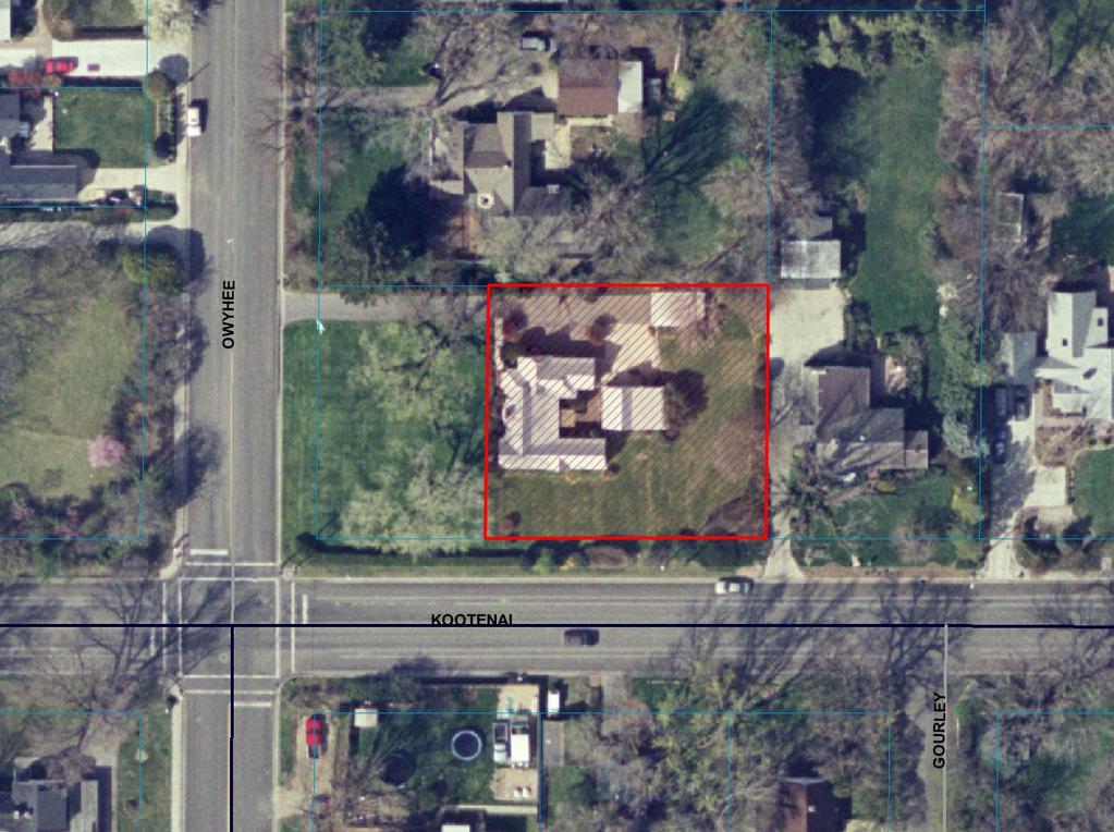
2 Subdivision Staff Report Subdivision Name Cranston Corner File Number SUB Subdivision Approval Preliminary/Final Plat Lead Agency Boise City Annexation Date October 12, 1948 Comp. Plan Complies Public Hearing Date December 4, 2007 Heard by Boise City Council Planning and Zoning Commission Approval August 6, 2007 Reviewed By David Abo, AICP Description: This is a proposed single family residential subdivision with two buildable lots on.39 acres. The density of the subdivision is 5.13 lots per acre. The subject property is currently zoned R-1C. The subject property is currently improved with a single family residence and accessory structure to remain on the proposed Lot 1. The applicant has indicated that the two proposed lots will take access from a common access easement. Location: The subject property is located on the north side of W. Kootenai Street approximately 76 feet east of S. Owyhee Street. Traffic: This development is estimated to generate 10 additional vehicle trips per day based on the Institute of Transportation Engineers Trip Generation Manual. Roadway Frontage Functional Classification Traffic Count Level of Service* Speed Limit S. Owyhee St. 1,534 north of Better 25 0 Collector (South of Kootenai) Overland on 2/9/06 than C MPH S. Owyhee St Local 1,575 north of Kootenai 25 0 N/A (North of Kootenai) Residential St. on 2/15/2006 MPH W. Kootenai St. 130 Collector 4,605 west of Owyhee Better 25 St. on 10/25/2005 than C MPH *Acceptable level of service for a two-lane Collector roadway is D (9,500 VTD).
3 Contents: Basis for Recommendation Vicinity Map Preliminary Plat Final Plat Aerial Map Recommended Conditions of Approval Technical Review and Agency Comments SUB / Cranston Corner Subdivision / Preliminary/Final Plat 2 of 20
4 3 of 20 Basis for Recommendation The Boise City Planning and Zoning Commission recommended approval of the Preliminary Plat of the Cranston Corner Subdivision on August 6, The plat design and layout is in conformance with the Comprehensive Plan and complies with the basic requirements of the Boise City Subdivision and Zoning Ordinances. Condition 1 Condition 2 Condition 3 Condition 4 Condition 5 Condition 6 Condition 7 This condition requires that a minimum five foot wide detached sidewalk be installed along W. Kootenai Street as it abuts the subject property. This condition addresses the required perpetual ingress/egress common use driveway easement. This condition addresses the required collector street buffer. This condition requires that the existing detached garage and carport be demolished or removed. This condition addresses on-street parking as per the International Fire Code. This condition requires compliance with all requirements of the Bench Sewer District. This condition requires compliance with all requirements of the Intermountain Gas Company. Staff Perspective General The recommended conditions of approval are required to bring the proposed Preliminary/Final Plat into compliance with Boise City and Idaho Codes and have been confirmed by the Boise City Planning and Development Services Department. Staff has reviewed the agency comments and Staff recommends approval based upon Staff's finding that all concerns of the commenting agencies have been addressed. To avoid potential problems the developer is directed to review the concerns identified in the technical reviews to verify that this statement is correct. Street Connectivity The subject property is bordered on the south by an existing public street. The subject property is bordered on the west, north and east by developed residential lots. In addition, the applicant is not proposing any new rights-of-way. As such, there is no opportunity to provide a stub street.
5 4 of 20 Sidewalk Design W. Kootenai Street as it abuts the subject property is not currently improved with sidewalk. Due to the fact that W. Kootenai Street is classified as a collector street, staff recommends that a minimum five foot wide detached sidewalk be installed along W. Kootenai as it abuts the subject property. Conditions in Dispute None known.
6
7
8
9
10 5 of 20 Special Conditions Recommended Conditions of Approval 1. A minimum five foot wide, detached sidewalk shall be installed along W. Kootenai Street as it abuts the subject property. 2. The plat shall include delineations that describe the boundaries of a perpetual ingress/egress common use driveway easement as indicated on the plat for Lots 1 and 2 and the adjoining parcel to the west abutting Owyhee Street. A. Design: Where practical the boundary of said easement shall align with the property line. The developer and/or owner shall also submit a site plan showing: B. Construction: Paving of the driveway and related utilities shall be constructed concurrently with all other required public improvements of this subdivision. Otherwise, the applicant shall bond for 110% of the value and enter into a nonbuild agreement for the affected lots until such time as the improvements are made. C. Addressing: Street address numbering shall be in accordance with B.C.C D. The developer and/or owner shall submit evidence that the address numbers posted on the structures on Lots 1 and 2, will be visible from the street. Otherwise, a signage plan shall be submitted to and approved by the Boise City Fire Department and the Boise City Planning and Development Services Department ensuring compliance with the Boise City Street Name and Addressing Ordinance. Additional signage may be required. D. Plat Note Requirements: Notes on the face of the Final Plat are required: 1. Which state, "Vehicular access to Lots 1 and 2, shall be provided from the common use driveway easement and not fromwest Kootenai Street. 2. Which set forth the legal description of the driveway and convey to those lot owners taking access from the driveway(s) and easement(s), the perpetual right of ingress and egress over the described driveway, and provides that such perpetual easement(s) shall run with the land. E. Covenant Requirements: A restrictive covenant or other similar deed restriction(s) acceptable to the Boise City Attorney shall be recorded at the time of recording the plat which provides:
11 6 of For the perpetual requirement for the maintenance of the driveway(s) and cross access easement, and 2. That said restrictions shall run with the land, and that said easement(s) and restrictions shall be reviewed and approved by the Boise City Attorney. 3. Prior to signing of the Final Plat by the Boise City Engineer, the plat shall include buffering along collectors and arterials as specified in Section K of the Boise City Subdivision Ordinance. More specifically, compliance with Section K.3 of the Boise City Subdivision Ordinance is required. A. Construction: Developer/owner may either construct the buffer area prior to final platting or post bond/agreement in the amount of 110% of the estimated costs with the Planning and Development Services Department prior to signing of the final plat by the Boise City Engineer. Construction of the buffer shall be in conformance with approved design plans. 2. The existing detached garage and carport shall be demolished. Demolition permit(s) are required and can be obtained by contacting the Planning and Development Services Department Permit Desk at In addition, Demolition Permit(s) shall be finaled prior to the Boise City Engineer signing the Final Plat. 3. For streets having a width less than 36 feet back of curb to back of curb parking shall be restricted on (1) one side; for streets having a width less than 29 feet back of curb to back of curb parking shall be restricted on both sides; and for standard ACHD cul-de-sacs parking shall be restricted on both sides. A note on the face of the Final Plat is required noting the parking restriction prior to signing of the Final Plat by the Boise City Engineer. 4. Compliance with all requirements of the Bench Sewer District is required. 5. Compliance with all requirements of the Intermountain Gas Company is required. Covenant Requirements 6. Covenants, homeowners association by-laws or other similar deed restrictions acceptable to the Boise City Attorney, which provide for the use, control and maintenance of all common areas, storage facilities, recreational facilities or open spaces shall be reviewed and approved by the Boise City Attorney.
12 7 of 20 Erosion Control Requirements 7. Prior to the City Engineer's Certification of the Final Plat and prior to earth disturbing activities, an erosion and sediment control (ESC) permit must be obtained. An ESC plan conforming to the requirements B.C.C. Title 8 Chapter 17, is to be submitted to the Director of Planning and Development Services for review and approval. No grading or earth disturbing activities may start until an approved ESC permit has been issued. 8. An individual who has attended the Boise City Responsible Person (RP) certification class, or has obtained Interim Certification for Responsible Person is not identified for this project. A permit will not issue until such time as the name and certification number of the RP has been provided to Boise City. This information can be faxed to or ed to swebb@cityofboise.org. Irrigation Conditions 9. Comply with Boise City Code Section J and Idaho State Code, Section concerning pressure irrigation requirements prior to signing of the Final Plat by the Boise City Engineer. A. The owner or person, firm or corporation filing the subdivision plat shall provide a pressurized irrigation system. The system must conform to the minimum design standards and specifications of Boise City or of the entity that will operate and maintain the system, if that entity has published standards. Fees: Developer and/or owner shall pay the current inspection and plan review fees on the proposed subdivision prior to signing of the Final Plat by the Boise City Engineer (B.C.C ). B. Developer may construct prior to Final Platting or bond in the amount of 110% of the estimated construction costs. C. Prior to either commencing construction or signing of the Final Plat by the Boise City Engineer, developer shall: 1. Submit construction plans and specifications for the pressurized system, stamped by a registered engineer, to the Department of Public Works and acquire approval there from. 2. Provide written assurance that provisions have been made for ownership, operation, and maintenance of the system.
13 8 of Delineate all necessary irrigation easements on the Final Plat (B.C.C F). D. Developer shall provide for an independent inspection of the installation of irrigation facilities and written certification by the design or project engineer that the system was installed according to the approved plans. In addition, the Department of Public Works must be present for the system pressure test and participate in a final inspection. 10. No ditch, pipe or structure for irrigation water or irrigation waste water shall be obstructed, rerouted, covered or changed in any way unless such obstruction, rerouting, covering or changing has first been approved in writing by the ditch company officer in charge. A. A copy of such written approval by the ditch company officer shall be filed with the construction drawing and submitted to the Department of Planning and Development Services prior to signing of the Final Plat by the Boise City Engineer (B.C.C F.2). 11. Fence, cover or tile all irrigation ditches, laterals or canals and drains, exclusive of natural waterways, intersecting, crossing or lying adjacent to the subdivision prior to Final Platting or post bond in the amount of 110% of the estimated improvement cost with the Boise City Planning and Development Services Department. "Adjacent" is defined by the Boise City Code as "located within less than sixty feet (60') of any lot included in the development." A. Any covering or fencing program involving the distribution of any irrigation district shall have the prior approval of the affected district. B. If the developer requests a water amenity, such request shall comply with B.C.C F.5. C. Fencing shall be installed within 90 days of the issuance of the first building permit in the development, if building permits are obtained prior to completion of fencing improvements. Sewer Conditions 12. The developer shall provide Boise City Public Works Department with a letter from the West Boise Sewer District stating that sewer has been installed and has been accepted for service or provide evidence, by way of contract or other means, which assures sewer service will be provided and that the necessary bonding are in place to assure completion of said sewer.
14 9 of 20 General Conditions 13. The developer shall make arrangements to comply with all requirements of the Boise City Fire Department and verify in one of the following ways: A. A letter from the Boise City Fire Department stating that all conditions for water, access, and/or other requirements have been satisfied, B. A non-build agreement has been executed and recorded with a note on the face of the Final Plat identifying the instrument number. OR NOTE: No Parking signs and curb painting shall be required on streets having a width less than 36-feet, back of curb to back of curb. Contact the Boise City Fire Department for sign placement and spacing. Developer may either construct prior to final platting or post bond in the amount of 110% of the estimated costs with the Boise City Planning and Development Services Department. 14. The name, Cranston Corner Subdivision, is reserved and shall not be changed unless there is a change in ownership, at which time, the new owner(s) shall submit their new name to the Ada County Engineer for review and reservation. Should a change in name occur, applicant shall submit, in writing, from the Ada County Engineer, the new name to the Department of Planning and Development Services and re-approval by the Council of the "revised" Final Plat shall be required. Developer and/or owner shall submit all items including fees, as required by the Planning and Development Services Department, prior to scheduling the "revised" Final Plat for hearing. 15. Correct street names as approved by the Ada County Street Name Committee shall be placed on the plat (I.C. Title 50, Chapter 13). 16. A letter of acceptance for water service from the utility providing same is required (B.C.C C). 17. Developer shall provide utility easements as required by the public utility providing service (B.C.C F). 18. A letter from the appropriate school district is required stating, "The Developer has made arrangements to comply with all requirements of the School District."
15 10 of Developer shall provide a letter from the United States Postal Service stating, "The Developer and/or Owner has received approval for location of mailboxes by the United States Postal Service." Contact: Dan Frasier, Postmaster 770 S. 13th St. Boise, ID Phone No. (208) FAX No. (208) Approval of sewer and water facilities by the Central District Health Department is required (I.C. Title 50, Chapter 13). 21. Developer shall comply with all construction standards of Ada County Highway District including approval of the drainage plan, requirements for installing curb, gutter, sidewalks and paving throughout the subdivision as specified by the Boise City Council. Signature by the Ada County Highway District on the plat is required (I.C. Title 50, Chapter 13). 22. Prior to submitting the Final Plat for recording, the following endorsements or certifications must be executed: Signatures of owners or dedicators, Certificate of the Surveyor, Certificate of the Ada County Surveyor, Certificate of the Central District Health Department, Certificate of the Boise City Engineer, Certificate of the Boise City Clerk, signatures of the Commissioners of the Ada County Highway District and the Ada County Treasurer (I.C. Title 50, Chapter 13). 23. Developer shall comply with B.C.C D.2 which specifies the limitation on time for filing and obtaining certification. Certification by the Boise City Engineer shall be made within two years from date of approval of the Final Plat by the Boise City Council. A. The developer may submit a request for a time extension, including the appropriate fee, to the Boise City Planning and Development Services Department for processing. Boise City Council may grant time extensions for a period not to exceed one year provided the request is filed, in writing, at least twenty working days prior to the expiration of the first two year period, or expiration date established thereafter. B. If a time extension is granted, the Boise City Council reserves the right to modify and/or add condition(s) to the original preliminary or Final Plat to conform with adopted policies and/or ordinance changes.
16 11 of 20 C. The Final Plat shall be recorded with the Ada County Recorder within one year from the date of the Boise City Engineer s signature. If the Final Plat is not recorded within the one-year time frame it shall be deemed null and void. 24. No building permit for the construction of any new structure shall be accepted until the Final Plat has been recorded pursuant to the requirements of the Boise City Subdivision Ordinance, Section A The Cranston Corner Subdivision is approved for two (2) buildable lots.
17 12 of 20 Technical Review and Agency Comments Boise City Planning and Development Services: Subdivision Section Todd Tucker Staff has reviewed the Preliminary/Final Plat and noted that all proposed lots conform to the minimum dimensional standards of the R1-C Zoning District. West Kootenai Street is identified as a collector street. As such, collector street buffering is required along W. Kootenai Street as per Section K. In addition, the submitted Preliminary Plat shows that a common access easement which will function as a private alley will be provided to act as the required buffer along W. Kootenai Street. Compliance with Section K.3 is required or a waiver must be granted. Each lot will have the required minimum 30 feet of frontage on a public street. However, both lots will be accessed via a common access easement from S. Owyhee Street. As such, the plat shall include delineations that describe the boundaries of a perpetual ingress/egress easement as indicated on the plat for Lots 1 and 2. Comprehensive Planning and Zoning Section Todd Tucker The subject property is currently zoned R-1C which allows for eight dwelling units per acre. The proposed subdivision has a density of 5.13 dwelling units per acre which is consistent with the R-1C Zoning District. Building Section Marlene Southard The existing detached garage and carport must be demolished. Demolition permit(s) are required and can be obtained by contacting the Planning and Development Services Department Permit Desk at Demolition Permit(s) must be finaled prior to the Boise City Engineer signing the Final Plat. Sediment and Erosion Control Steve Webb An erosion and sediment control plan (ESC) conforming to the requirements B.C.C. Title 8 Chapter 17 is to be submitted to the Director of Planning and Development Services for review. No grading or earth disturbing activities may start until approval of the ESC plan has been received and an ESC permit issued. An individual who has attended the Boise City Responsible Person (RP) certification class, or has obtained Interim Certification for Responsible Person is not identified for this project. A permit will not issue until such time as the name and certification number of the RP has been provided to Boise City. Boise City Public Works: Drainage/Engineering Rob Bousfield
18 13 of 20 Standard drainage condition. Pressure Irrigation - Kent Johnson Compliance with Idaho Code, Section and Boise City Code Section J is required. Sewer - John Johnson The property is located within the Bench Sewer District. Street Lights - Henry Alarcon No new street lights are required. Boise City Fire Department Mark Senteno The Boise Fire Department has reviewed this application and can approve the Plat with the following conditions. Any deviation from this plan is subject to Fire Department approval. Please note that unless stated otherwise this memo represents requirements of the International Fire Code as adopted and amended by Ordinance Specific Requirement: Fire Department vehicular access shall be provided to within 150' of all portions of the nonsprinklered buildings. This distance can be increased somewhat for sprinklered buildings but exact distances are on a case-by-case basis. All Fire Department access roads, fire lanes, bridges, and gates are to be a minimum of 20' wide with 13' 6" overhead clearance, shall be capable of supporting 70,000 lbs GVW (24,000 lbs per axle), and shall be paved. Fire Department access roads and fire lanes shall have a minimum outside turning radius of 48' with an inside radius of 28'. Any dead-end road in excess of 150' needs a Fire Department approved turnaround. No grade may exceed 10% (please note that fire apparatus are designed for a maximum 6% grade). Dead end roads are prohibited from exceeding 700 feet. Width and turning radius measurements specified by this paragraph can include those surfaces vehicles generally drive upon. Specifically, gutter and rolled curb are generally considered useable, while vertical curb or sidewalks are not. Specific Requirement: For streets having a width less than 36 feet back of curb to back of curb parking shall be restricted on (1) one side; for streets having a width less than 29 feet back of curb to back of curb parking shall be restricted on both sides; and for standard ACHD cul-de-sacs parking shall be restricted on both sides. A note on the face of the final plat is required noting the parking restriction prior to signing of the final plat by the Boise City Engineer. In addition, No Parking signs shall be installed in accordance with the requirements of the IFC. Specific Condition: Streets must be marked accordingly.
19 14 of 20 Specific Requirement: Maximum hydrant spacing for this project is 500 feet between hydrants. Specific Condition: One fire hydrant has been noted. In the absence of information on existing hydrants it appears that no new hydrant may/will be needed. However, we reserve the right to modify requirements as more information comes to light. Variables affecting hydrant numbers and location include, but are not limited to, area, construction type, existing hydrants, accuracy of information provided in the application, strategic location for fire fighting forces, and required fire flow. New hydrants must be "non-private" installations. General Requirement: Fire Department required fire hydrants, access, and street identification shall be installed prior to construction or storage of combustible materials on site. Provisions may be made for temporary access and identification measures. Specific building construction requirements of the International Building Code, International Fire Code, and Boise City Code will apply. However, these provisions are best addressed by a licensed Architect at building permit application. Boise City Parks Department Cheyne Weston No comments received. Boise Airport Matt Petaja No comments received. Ada County Highway District Coby Harrod A. Findings of Fact Existing Conditions 1. Site Information: The site is currently occupied by one single family residence with a detached garage. 2. Description of Adjacent Surrounding Area: Direction Land Use Zoning North Single Family Residential R-1C South Single Family Residential R-1C East Single Family Residential R-1C West Single Family Residential R-1C 3. Existing Roadway Improvements and Right-of-Way Adjacent To and Near the Site:
20 15 of 20 Owyhee St. is currently improved with two travel lanes, two bike lanes and parking on both sides of the street near the site. There is also vertical curb, gutter and no sidewalk near the site. Owyhee St. currently has 80-feet of right-of-way. Kootenai St. is currently improved with two travel lanes, vertical curb, gutter and no sidewalk abutting the site. Kootenai St. currently has 80-feet of right-of-way 4. Existing Access: There is one paved access to the site at the north-west property line. 5. Site History: ACHD has not previously reviewed this site for a development application. A lot split was recently approved on this site to create a parcel directly at the northeast corner of Owyhee St. and Kootenai St. Development Impacts 6. Trip Generation: This development is estimated to generate 10 additional vehicle trips per day based on the Institute of Transportation Engineers Trip Generation Manual. 7. Impact Fees: There will be an impact fee that is assessed and due prior to issuance of any building permits. The assessed impact fee will be based on the impact fee ordinance that is in effect at that time. 8. Traffic Impact Study: A traffic impact study was not required with this application. 9. Impacted Roadways: Roadway Frontage Functional Classification S. Owyhee St. (South of 0 Collector Kootenai) S. Owyhee St Local (North of 0 Residential Kootenai) W. Kootenai St. Traffic Count Level of Service* 1,534 north of Overland on 2/9/06 1,575 north of Kootenai St. on 2/15/2006 Better than C N/A Speed Limit 25 MPH 25 MPH 4,605 west of Better than 130 Collector Owyhee St. on 25 MPH C 10/25/2005 *Acceptable level of service for a two-lane Collector roadway is D (9,500 VTD). 10. Capital Improvements Plan/Five Year Work Program: There is currently no improvement s scheduled for this area in the Capital Improvement Plan or the Five Year Work Program. B. Findings for Consideration
21 16 of W. Kootenai St. Street Section Policy: District policy 72-F1B requires collector roadways to be constructed as 46- foot street sections with vertical curb, gutter, and 5-foot detached (or 7-foot attached) concrete sidewalks within 70-feet of right-of-way. This street section allows for the construction of a 3-lane roadway with bike lanes. Applicant Proposal: The applicant is not proposing any improvements to W. Kootenai Street. Staff Comment/Recommendation: The applicant will be required to construct a 7-foot attached sidewalk at the existing back of curb, or a 5-foot detached sidewalk located a minimum of 5-feet from back of curb. 2. Driveways Driveway Policy: Graveled driveways abutting public streets create maintenance problems due to gravel being tracked onto the roadway. In accordance with District policy, , the applicant should be required to pave the driveway its full width and at least 30-feet into the site beyond the edge of pavement of the roadway and install pavement tapers with 15-foot radii abutting the existing roadway edge. District Policy restricts residential driveways to a maximum width of 20-feet. Applicant Proposal: The applicant is proposing a shared access driveway that intersects S. Owyhee St. approximately 120-feet from W. Kootenai St. (measured near edge to near edge). Staff Comment/Recommendation: The applicant s proposal meets District policy and should be approved with this application. 3. Tree Planters Tree Planter Policy: The District s Tree Planter Width Interim Policy prohibits all trees in planters less than 6-feet in width. In addition to prohibiting trees in planters less than 6-feet in width, the policy requires a minimum planter width of 6-feet for class II tress with the installation of root barriers on both sides of the planter strip or a minimum planter width of 8-feet without the installation of a root barrier. The policy also requires Class I and Class III trees to provide a minimum planter width of 10-feet. C. Site Specific Conditions of Approval 1. Construct a 7-foot attached concrete sidewalk located at the back of existing curb or construct a 5-foot detached concrete sidewalk located 5-feet form existing curb for the entire frontage of the site abutting W. Kootenai St.
22 17 of Construct a driveway as a shared access, paved to its full width of no greater than 20-feet and paved atleast 30-feet into the site beyond the edge of S. Owyhee St. 3. Comply with all Standard Conditions of Approval. D. Standard Conditions of Approval 1. Any existing irrigation facilities shall be relocated outside of the right-of-way. 2. Private sewer or water systems are prohibited from being located within any ACHD roadway or right-of-way. 3. All utility relocation costs associated with improving street frontages abutting the site shall be borne by the developer. 4. Replace any existing damaged curb, gutter and sidewalk and any that may be damaged during the construction of the proposed development. Contact Construction Services at (with file number) for details. 5. Comply with the District s Tree Planter Width Interim Policy. 6. Utility street cuts in pavement less than five years old are not allowed unless approved in writing by the District. Contact the District s Utility Coordinator at (with file numbers) for details. 7. All design and construction shall be in accordance with the Ada County Highway District Policy Manual, ISPWC Standards and approved supplements, Construction Services procedures and all applicable ACHD Ordinances unless specifically waived herein. An engineer registered in the State of Idaho shall prepare and certify all improvement plans. 8. The applicant shall submit revised plans for staff approval, prior to issuance of building permit (or other required permits), which incorporates any required design changes. 9. Construction, use and property development shall be in conformance with all applicable requirements of the Ada County Highway District prior to District approval for occupancy. 10. Payment of applicable road impact fees are required prior to building construction. The assessed impact fee will be based on the impact fee ordinance that is in effect at that time. 11. It is the responsibility of the applicant to verify all existing utilities within the right-ofway. The applicant at no cost to ACHD shall repair existing utilities damaged by the applicant. The applicant shall be required to call DIGLINE ( ) at least
23 18 of 20 two full business days prior to breaking ground within ACHD right-of-way. The applicant shall contact ACHD Traffic Operations in the event any ACHD conduits (spare or filled) are compromised during any phase of construction. 12. No change in the terms and conditions of this approval shall be valid unless they are in writing and signed by the applicant or the applicant s authorized representative and an authorized representative of the Ada County Highway District. The burden shall be upon the applicant to obtain written confirmation of any change from the Ada County Highway District. 13. Any change by the applicant in the planned use of the property which is the subject of this application, shall require the applicant to comply with all rules, regulations, ordinances, plans, or other regulatory and legal restrictions in force at the time the applicant or its successors in interest advises the Highway District of its intent to change the planned use of the subject property unless a waiver/variance of said requirements or other legal relief is granted pursuant to the law in effect at the time the change in use is sought. E. Conclusions of Law 1. The proposed site plan is approved, if all of the Site Specific and Standard Conditions of Approval are satisfied. 2. ACHD requirements are intended to assure that the proposed use/development will not place an undue burden on the existing vehicular transportation system within the vicinity impacted by the proposed development. Ada County Street Name Committee The following existing street names shall appear on the plat: W. Cassia Street W. Kootenai Street S. Owyhee Street S. Shoshone Street Bench Sewer District Guy Hopkins The Bench Sewer District does not have an immediate objection to the above mentioned design review application. Please be advised that the developer and/or property owner must contact our Permit Department for the appropriate application and fee schedule PRIOR to construction/remodel activities. The application for connection, list of requirements and fee schedules can be obtained from the District Office Monday through Friday, during the hours of 8:00 a.m. to 5:00 p.m.
24 19 of 20 Central District Health Department Malcohm McGregor After written approval from appropriate entities is submitted, we can approve this proposal for central sewage and central water. The following plans must be submitted to and approved by the Idaho Department of Health and Welfare, Division of Environmental Quality: A. Central Sewage B. Central Water Street runoff is not to create a mosquito breeding problem. STORMWATER MANAGEMENT RECOMMENDATIONS It is recommended that storm water be pre-treated prior to discharge to the subsurface to prevent impact to ground water and surface water quality. The engineers and architects involved with the design of this project should obtain current best management practices for stormwater disposal and design a stormwater management system that is preventing groundwater and surface water degradation. Manuals that could be used for guidance are: Stormwater Best Management Practices Guidebook Prepared by the Boise City Public Works Department, May State of Idaho Catalog of Stormwateter Best Management Practices for Idaho Cities and Counties Prepared by the Idaho Division of Environmental Quality, July Independent School District of Boise City #1 Sarah Stobaugh At the present time, the Developer and/or Owner have made arrangements to comply with all requirements of the Boise School District. The schools currently assigned to the proposed project area are: Elementary School: Monroe Junior High School: South High School: Borah Intermountain Gas Company Mishelle Singleton Intermountain Gas Company has received your letter of application. In order to best serve this development Intermountain Gas does require that a 5 minimum utility easement along the interior lot lines and a 10 minimum utility easement along all right of ways or private
25 20 of 20 drive. The private drive of the development would also be required to include a utility easement for Intermountain Gas to encroach into with the gas lines. United States Postal Service Dan Frasier, Postmaster The City of Boise and Ada County have agreed that no Final Plat maps will be approved without the following condition being met. Prior to the signing of the Final Plat by the City Engineer, the Developer and/or Owner shall provide an letter from the United States Postal Service stating, The Developer and/or Owner has received approval for location of mailboxes by the United States Postal Service. Contact: Dan Frasier, Postmaster 770 S. 13 th Street. Boise, ID Phone: (208) Fax: (208) The following are the basic conditions requested by the Postal Service. 1. In all new residential areas, service will be provided to Cluster Box Units (CBU s). It will be the responsibility of the contractor to pour a cement pad meeting the required specifications in a location(s) approved by the Postal Service. 26. The clustering of all boxes in one approved area is recommended for multi-family dwellings, e.g., condos, duplexes, triplexes, etc. All locations must still be approved. 27. Fill-in development, defined as three or less residential lots, may receive the existing mode of delivery as the rest of the neighborhood. All locations must still be approved.
Subdivision Staff Report
 Subdivision Staff Report Subdivision Name Coldstream File Number SUB06-00040 Subdivision Approval Preliminary Plat Lead Agency Boise City Annexation Date December 9, 1974 Comp. Plan Complies Public Hearing
Time Extension Staff Report
 Time Extension Staff Report Subdivision Name Therrin Subdivision File Number SUB06-00020 Approval Time Extension for Lead Agency Boise City Certification Signature of Boise City Engineer Annexation Date
Time Extension Staff Report
 Time Extension Staff Report Subdivision Name Lunara Subdivision File Number SUB07-00019 Approval Time Extension for Lead Agency Boise City Certification Signature of Boise City Engineer Annexation Date
Subdivision Staff Report
 Subdivision Staff Report Subdivision Name Toli Park Subdivision File Number SUB07-00035 Approval Preliminary Plat Lead Agency Boise City Annexation Date December 30, 1987 Comp. Plan Complies Public Hearing
Subdivision Staff Report
 Subdivision Staff Report Subdivision Name Honeymoon Cove Subdivision File Number SUB08-00005 Approval Preliminary/ Final Plat Lead Agency Boise City Annexation Date December 30, 2004 Comp. Plan Complies
Subdivision Staff Report
 Subdivision Staff Report Subdivision Name Madera Creek File Number SUB06-00068 Subdivision Approval Final Plat Lead Agency Boise City Annexation Date December 9, 1974 Comp. Plan Complies Public Hearing
Location: The subject property is located at the northeast corner of S. Holden Lane and E. Boise Avenue.
 Subdivision Staff Report Subdivision Name Tianna Park File Number SUB11-00008 Approval Preliminary Plat Lead Agency Boise City Annexation Date December 19, 1977 Comp. Plan Complies Public Meeting Date
Subdivision Staff Report
 Subdivision Staff Report Subdivision Name Greenfield Park File Number SUB06-00110 Subdivision Approval Preliminary/Final Plat Lead Agency Boise City Annexation Date December 9, 1974 Comp. Plan Complies
Subdivision Staff Report
 Subdivision Staff Report Subdivision Name Birmingham Place File Number SUB06-00051 Subdivision Approval Preliminary/Final Plat Lead Agency Boise City Annexation Date December 3, 1962 Comp. Plan Complies
Subdivision Staff Report
 Subdivision Staff Report Subdivision Name Athletic Subdivision File Number SUB08-00023 Approval Preliminary/ Final Plat Lead Agency Boise City Annexation Date July 30, 1984 Comp. Plan Complies Public Hearing
Committed to Service
 Committed to Service Paul Woods, President Rebecca W. Arnold, Vice President Sara M. Baker, Commissioner Jim D. Hansen, Commissioner Kent Goldthorpe, Commissioner August 25, 2017 Development Services TO:
Date: March 16, Jake Centers ERD, LLC P.O. Box 1610 Eagle, ID Elevation Ridge Subdivision (SUB & PUD ) Street Address
 Street Address") Rebecca W. Arnold, President Sara M. Baker, Vice President John S. Franden, Commissioner Carol A. McKee, Commissioner David L. Case, Commissioner Date: March 16, 2012 To: Jake Centers ERD, LLC P.O. Box
Rebecca W. Arnold, President Sara M. Baker, Vice President John S. Franden, Commissioner Carol A. McKee, Commissioner David L. Case, Commissioner Date: March 16, 2012 To: Jake Centers ERD, LLC P.O. Box
May 21, ACHD Board of Commissioners Stacey Yarrington, Planner II DRH /DRH
 Development Services Department May 21, 2013 TO: FROM: SUBJECT: ACHD Board of Commissioners Stacey Yarrington, Planner II DRH13-00106/DRH13-00108 Executive Summary: This is a design review application
BOI / DRH Albertsons grocery market and fueling center & pad sites
 Paul Woods, President Rebecca W. Arnold, Vice President Sara M. Baker, Commissioner Jim D. Hansen, Commissioner Kent Goldthorpe, Commissioner March 28, 2017 To: Mark Palmer Albertsons Companies 250 E.
Subdivision Staff Report
 Subdivision Staff Report Subdivision Name Sunnyridge Subdivision File Number SUB07-00007 Approval Preliminary Plat Lead Agency Ada County Annexation Date NA Comp. Plan Complies (With Conditions of Approval)
Subdivision Staff Report
 Subdivision Staff Report Subdivision Name Cayenne Corner File Number SUB06-00060 Subdivision Approval Final Plat Lead Agency Boise City Annexation Date January 1, 1987 Comp. Plan Complies Public Hearing
If you have any questions, please feel free to contact me at (208)
") Sara M. Baker, President John S. Franden, Vice President Rebecca W. Arnold, Commissioner Mitchell A. Jaurena, Commissioner Jim Hansen, Commissioner Date: March 21, 2013 To: Subject: Hornet Construction
Sara M. Baker, President John S. Franden, Vice President Rebecca W. Arnold, Commissioner Mitchell A. Jaurena, Commissioner Jim Hansen, Commissioner Date: March 21, 2013 To: Subject: Hornet Construction
Right-of-Way & Development Services Planning Review Division Committed to Service This application is approved at the staff level on February 1, 2006.
 Right-of-Way & Development Services Planning Review Division Committed to Service This application is approved at the staff level on February 1, 2006. Tech Review for this item was held with the applicant
Executive Summary: This is a preliminary plat to construct 8 residential lots and 2 commons lots with a private road on 3.87-acres in Meridian, Idaho.
 Development Services Department DATE: July 7, 2015 TO: FROM: SUBJECT: ACHD Board of Commissioners Stacey Yarrington, Planner III Kentucky Villas/ MPP15-0012/ PP15-009 Executive Summary: This is a preliminary
Amended Subdivision Staff Report
 Amended Subdivision Staff Report Subdivision Name Silverpine Subdivision File Number SUB06-00052 No.2 Approval Preliminary Plat Lead Agency Ada County Annexation Date NA Comp. Plan Complies (With Conditions
Committed to Service
 Committed to Service Kent Goldthorpe, President Paul Woods, Vice President Rebecca W. Arnold, Commissioner Sara M. Baker, Commissioner Jim D. Hansen, Commissioner July 18, 2016 Development Services TO:
Hal Simmons Planning Director Boise City Planning and Development Services. CAR / 1689 South Entertainment Avenue
 MEMORANDUM MEMO TO: FROM: Mayor and Boise City Council Hal Simmons Planning Director Boise City Planning and Development Services DATE: November 15, 2008 RE: CAR08-00019 / 1689 South Entertainment Avenue
3. The preliminary plats were approved on March 27, 2014 and August 14, 2014.
 Jim D. Hansen, President Sara M. Baker, Vice President Rebecca W. Arnold, Commissioner Kent Goldthorpe, Commissioner Paul Woods, Commissioner February 12, 2015 Development Services Department To: From:
SUB /CAR /PUD
 Development Services Department Project/File: Lead Agency: Site address: Balntyre Court Subdivision/BPP16-0036/ SUB16-00066/CAR16-00035/PUD16-00040 This is a rezone, planned unit development, and subdivision
Subdivision Staff Report
 Subdivision Staff Report Name: Brownstone Subdivision Date: May 12, 2004 File: SUB04-00041 Meeting: May 18, 2004 Approval: Preliminary To: City Council Lead Agency: Ada County (04-10-S) From: Richard Beck
Committed to Service
 Committed to Service Sara M. Baker, President Rebecca W. Arnold, Vice President Jim D. Hansen, Commissioner Kent Goldthorpe, Commissioner Paul Woods, Commissioner January 16, 2018 Development Services
Date: August 29, Dave Scaggs (sent via ) Summit Development Inc th Ave. Rd. #384 Nampa, ID 83686
 Summit Development Inc th Ave. Rd. #384 Nampa, ID 83686") Sara M. Baker, President John S. Franden, Vice President Rebecca W. Arnold, Commissioner Mitchell A. Jaurena, Commissioner Jim Hansen, Commissioner Date: August 29, 2013 To: Dave Scaggs (sent via email)
Sara M. Baker, President John S. Franden, Vice President Rebecca W. Arnold, Commissioner Mitchell A. Jaurena, Commissioner Jim Hansen, Commissioner Date: August 29, 2013 To: Dave Scaggs (sent via email)
#1 (CAR /SUB )
") Development Services Department Project/File: Lead Agency: Site address: Fork South #1 (CAR14-00009/SUB14-00024) The applicant is requesting annexation, rezone and preliminary plat approvals for a 52-lot
Development Services Department Project/File: Lead Agency: Site address: Fork South #1 (CAR14-00009/SUB14-00024) The applicant is requesting annexation, rezone and preliminary plat approvals for a 52-lot
Subdivision Staff Report
 Subdivision Staff Report Subdivision Name Watertower Place File Number SUB08-00008 Subdivision Approval Preliminary/Final Plat Lead Agency Boise City Annexation Date December 31, 1965 Comp. Plan Complies
RE: CAR / 4280 N.
 MEMORANDUM TO: FROM: Mayor and Boise City Council Hal Simmons - Planning Director Boise City Planning and Development Services DATE: April 29, 2009 RE: CAR09-00006 / 4280 N. Eagle Road The following application
Committed to Service. License Agreement Application Form
 Committed to Service License Agreement Application Form PLEASE NOTE: Effective February 16, 2010 - License Agreements within the downtown Boise area for public structures, objects and uses on ACHD sidewalks
WRITTEN DECISION OF THE HAYDEN CITY COUNCIL REGARDING MAPLE GROVE PRELIMINARY SUBDIVISION APPLICATION (SUB-0013) HAYDEN SIGNATURE, LLC
 HAYDEN SIGNATURE, LLC") WRITTEN DECISION OF THE HAYDEN CITY COUNCIL REGARDING MAPLE GROVE PRELIMINARY SUBDIVISION APPLICATION (SUB-0013) HAYDEN SIGNATURE, LLC Application of Hayden Signature, LLC, an Idaho limited liability company,
WRITTEN DECISION OF THE HAYDEN CITY COUNCIL REGARDING MAPLE GROVE PRELIMINARY SUBDIVISION APPLICATION (SUB-0013) HAYDEN SIGNATURE, LLC Application of Hayden Signature, LLC, an Idaho limited liability company,
a. provide for the continuation of collector streets and thoroughfare streets between adjacent subdivisions;
 Section 7.07. Intent The requirements of this Section are intended to provide for the orderly growth of the Town of Holly Springs and its extra-territorial jurisdiction by establishing guidelines for:
SECTION 7000 LAND DEVELOPMENT REQUIREMENTS
 SECTION 7000 LAND DEVELOPMENT REQUIREMENTS 7000 LAND DEVELOPMENT REQUIREMENTS... 1 7001 LEGISLATIVE AUTHORITY... 1 7001.1 LAND DEVELOPMENT... 1 7001.1.1 Title 40, Idaho Code... 1 7001.1.2 Idaho Code 40-1415
ARTICLE IV: DEVELOPMENT STANDARDS
 ARTICLE IV: DEVELOPMENT STANDARDS IV-53 409 PRIVATE STREETS A private street means any way that provides ingress to, or egress from, property by means of vehicles or other means, or that provides travel
Section Preliminary Plat Checklist and Application Forms
 Section 201 - Preliminary Plat Checklist and Application Forms PRELIMINARY SUBDIVISION PLAT REVIEW PROCESS CHART PRELIMINARY SUBDIVISION PLAT APPLICATION PRELIMINARY PLAT REVIEW CHECKLIST CITY OF NAMPA
INTEROFFICE MEMORANDUM
 INTEROFFICE MEMORANDUM DATE: February 3, 2009 TO: Public Works Commission FROM: Mike Sheppard, P.E, Civil Engineer SUBJECT: Appeal of Boise City Public Works Denial of Request for an Alternative Sewer
BYRON TOWNSHIP ZONING APPLICATION
 BYRON TOWNSHIP ZONING APPLICATION Phone: (616) 878-9104 * Fax: (616) 878-3980 * Website: www.byrontownship.org This application will not be accepted if incomplete. APPLICATION FOR & REQUIRED COPIES Private
ARTICLE 24 PRIVATE ROAD, SHARED PRIVATE DRIVEWAY AND ACCESS EASEMENT STANDARDS
 ARTICLE 24 PRIVATE ROAD, SHARED PRIVATE DRIVEWAY AND ACCESS EASEMENT STANDARDS SECTION 24.00 INTENT AND PURPOSE The standards of this Article provide for the design, construction and maintenance of private
APPLICATION PROCEDURE
 ANTRIM PLANNING BOARD P. O. Box 517 Antrim, New Hampshire 03440 Phone: 603-588-6785 FAX: 603-588-2969 APPLICATION FORM AND CHECKLIST FOR MINOR OR MAJOR SITE PLAN REVIEW File Date Received By APPLICATION
DIVISION 2 - CONSTRUCTION PLAN AND MISCELLANEOUS REQUIREMENTS
 DIVISION 2 - CONSTRUCTION PLAN AND MISCELLANEOUS REQUIREMENTS 2.1 Required Plan Sheets 2.2 Drawing Requirements 2.3 Graphic Standards 2.4 Easements 2.5 Utility Locations 2.6 Private Facility Locations
SOS / Waiver of Subdivision Standards / John Cashin
 SOS15-00012 / Waiver of Subdivision Standards / John Cashin Summary John Cashin requests a Waiver of Subdivision Standards in the Boise Development Code that requires construction of new sidewalk for approval
LAND USE APPLICATION
 LAND USE APPLICATION File Name: File No(s).: Receipt No.: Receipt Date: Received By: Amount.: $ Instructions for Applicants Please read and follow all instructions on your application carefully. If you
SUB / Diamante Subdivision / Northside Management
 SU15-00062 / Diamante Subdivision / Northside Management Summary: Subdivision application for a Preliminary Plat consisting of 20 buildable lots and 3 common lots. Prepared y: Todd Tucker, Senior Planner
DRIVEWAY REQUIREMENTS
 APPLICATION FOR: RESIDENTIAL DRIVEWAY / ACCESS Zoning Review Mail: - 101 White Ave. S.E. - Live Oak, FL 32064 Office: City Hall Annex - 416 Howard Street E - Live Oak, FL 32064 Phone: 386.362.2276 ofc.
Residential Major Subdivision Review Checklist
 Residential Major Subdivision Review Checklist Plan Submittal Requirements: 2 full sets of stamped plans Electric submittal - all plans contained in a single PDF 3 full sets if commercial kitchen or dining
-MENDOCINO COUNTY PLANNING AND BUILDING SERVICES- DIVISION OF LAND REGULATIONS TITLE 17
 ARTICLE VI -- GENERAL REGULATIONS AND PROVISIONS Sec. 17-50. Sec. 17-51 General Plan. Sec. 17-52 Lot and Block Design and Configuration. Sec. 17-53 Lot Access. Sec. 17-54 Private Roads. Sec. 17-55 Water
M-43 CORRIDOR OVERLAY ZONE
 ARTICLE 26.00 M-43 CORRIDOR OVERLAY ZONE Section 26.01 Findings A primary function of the M-43 state highway is to move traffic through the Township and to points beyond. As the primary east-west arterial
ROAD APPROACH ORDINANCE #44 TILLAMOOK COUNTY OREGON. ADOPTED September 18, UPDATED June 23, UPDATED June 28, UPDATED July 24, 1996
 ROAD APPROACH ORDINANCE #44 TILLAMOOK COUNTY OREGON ADOPTED September 18, 1991 UPDATED June 23, 1993 UPDATED June 28, 1995 UPDATED July 24, 1996 UPDATED June 23, 1999 UPDATED January 1, 2009 UPDATED November
DAUPHIN CREEK ESTATES SUBDIVISION
 # 12 SUB-000076-2017 DAUPHIN CREEK ESTATES SUBDIVISION Engineering Comments: FINAL PLAT COMMENTS (should be addressed prior to submitting the FINAL PLAT for review and/or signature by the City Engineer):
TOWN OF LEWISTON PLANNING BOARD APPLICATION
 TOWN OF LEWISTON PLANNING BOARD APPLICATION DESCRIPTION OF PROPOSED REQUEST: Name of Property Owner: Phone #: Name of Applicant:Phone #: Address or Location of Proposal:_SBL# Size of Parcel or Structure:Existing
Committed to Service
 Development Services Department Committed to Service June 23, 2015 TO: FROM: SUBJECT: ACHD Board of Commissioners Mindy Wallace, AICP Planner III Linder Apartments - EAG15-0005/ CPA-01-15/A-01-15/RZ-04-15
ARTICLE 15. RULES, REGULATIONS AND DEFINITIONS
 ARTICLE 15. RULES, REGULATIONS AND DEFINITIONS Section 1. Interpretation and Construction: The following rules and regulations regarding interpretation and construction of the Ulysses-Grant County, Kansas,
CONCEPT PLAN APPLICATION Meeting with Staff Commercial Projects
 COMMUNITY DEVELOPMENT City of South Salt Lake Community Development Department 220 E. Morris Avenue South Salt Lake City, Utah 84115 Phone (801) 483-6011 Fax (801) 483-6060 CONCEPT PLAN APPLICATION Meeting
ZONING AMENDMENT, PLANNED UNIT DEVELOPMENT & SUBDIVISION STAFF REPORT Date: September 15, 2011
 ZONING AMENDMENT, PLANNED UNIT DEVELOPMENT & SUBDIVISION STAFF REPORT Date: September 15, 2011 NAME SUBDIVISION NAME LOCATION Stratford, L.L.C. Grelot Office Park Subdivision North side of Grelot Road,
SOS ; State of Idaho, Consent to Partially Vacate Public Alley Rightof-Way at 611 North 6 th Street
 MEMORANDUM TO: FROM: Mayor and City Council David Abo, AICP Subdivision Review Analyst Boise City Planning and Development Services DATE: November 6, 2012 RE: SOS12-00013; State of Idaho, Consent to Partially
ORDINANCE NO. Be it ordained by the City Council of the City of Abilene, Texas:
 ORDINANCE NO. An ordinance repealing Chapter 23, Subpart B of the Code of the City of Abilene, Texas, entitled Mobile Homes and Vacation Travel Trailers; stating the authority; setting forth the scope
Condominium Unit Requirements.
 ARTICLE 19 CONDOMINIUM REGULATIONS Section 19.01 Purpose. The purpose of this Article is to regulate projects that divide real property under a contractual arrangement known as a condominium. New and conversion
JEFFERSON COUNTY, ALABAMA
 JEFFERSON COUNTY, ALABAMA Major Development Checklist, Notes and Information A Major Development is any proposed new structure or addition to an existing structure which will cause a change in the topography
Planning Department st Avenue East Kalispell, MT Phone: (406) Fax: (406)
 Fax: (406)") Planning Department 201 1 st Avenue East Kalispell, MT 59901 Phone: (406) 758-7940 Fax: (406) 758-7739 www.kalispell.com/planning April 1, 2015 Doug Russell, City Manager City of Kalispell 201 1 st Ave
Planning Department 201 1 st Avenue East Kalispell, MT 59901 Phone: (406) 758-7940 Fax: (406) 758-7739 www.kalispell.com/planning April 1, 2015 Doug Russell, City Manager City of Kalispell 201 1 st Ave
ARTICLE 23 CONDOMINIUM STANDARDS
 ARTICLE 23 CONDOMINIUM STANDARDS Section 23.01 Intent. The intent of this Article is to provide regulatory standards for condominiums and site condominiums similar to those required for projects developed
ARTICLE 3 DEFINITIONS
 Sections: 3-1 Rules of Construction 3-2 Definitions ARTICLE 3 DEFINITIONS SECTION 3-1 RULES OF CONSTRUCTION 3-101. a. The language set forth in these regulations shall be interpreted in accordance with
ARTICLE 4 PERMITS REQUIRED FOR DEVELOPMENT OR CONSTRUCTION 4.1 AUTHORIZATION REQUIRED FOR LAND DISTURBANCE OR DEVELOPMENT ACTIVITIES
 ARTICLE 4 PERMITS REQUIRED FOR DEVELOPMENT OR CONSTRUCTION 4.1 AUTHORIZATION REQUIRED FOR LAND DISTURBANCE OR DEVELOPMENT ACTIVITIES 4.1.1 Permit Required - Exemptions: No disturbance of the land, including
Planning Director Boise City Planning and Development Services Department. CUP (Adoption of Findings & Revised Conditions of Approval)
") MEMORANDUM TO: FROM: Mayor and Boise City Council Hal Simmons Planning Director Boise City Planning and Development Services Department DATE: May 19, 2006 RE: CUP05-00172 (Adoption of Findings & Revised
MEMORANDUM TO: FROM: Mayor and Boise City Council Hal Simmons Planning Director Boise City Planning and Development Services Department DATE: May 19, 2006 RE: CUP05-00172 (Adoption of Findings & Revised
Appendix A. Definitions
 Definitions 1. Terms Defined. Words contained in this are those having a special meaning relative to the purposes of this Ordinance. Words not listed in this section shall be defined by reference to: (1)
THE COUNTY BOARD OF SUPERVISORS OF THE COUNTY OF DOUGLAS DOES ORDAIN AS FOLLOWS:
 8.1 SUBDIVISION CONTROL ORDINANCE THE COUNTY BOARD OF SUPERVISORS OF THE COUNTY OF DOUGLAS DOES ORDAIN AS FOLLOWS: SECTION I. GENERAL INTERPRETATION This ordinance shall not repeal, impair or modify private
COMMERCIAL SITE PLAN & CONDITIONAL USE PERMIT REVIEW PROCESS & CHECKLIST
 Community Development 110 South Main Street Springville, UT 84663 COMMERCIAL SITE PLAN & CONDITIONAL USE PERMIT REVIEW PROCESS & CHECKLIST 801.491.7861 www.springville.org Prior to the issuance of a building
This Ordinance is adopted under the authority and provisions of the General Statutes of North Carolina, Article 6, Chapter 153A 121.
 Section 74, Regulations Governing Manufactured Home Parks 1. Purpose The purpose of these regulations to be known and cited as the Madison County Manufactured Home Park Ordinance is to regulate and guide
RESIDENTIAL CLUSTER DEVELOPMENT DISTRICT SPECIAL PERMIT RULES AND REGULATIONS OF THE PLANNING BOARD OF THE TOWN OF COHASSET, MASSACHUSETTS
 RESIDENTIAL CLUSTER DEVELOPMENT DISTRICT SPECIAL PERMIT RULES AND REGULATIONS OF THE PLANNING BOARD OF THE TOWN OF COHASSET, MASSACHUSETTS Attached: Residential Cluster Development District Special Permit
BEAR CREEK TOWNSHIP EMMET COUNTY, MICHIGAN. PRIVATE ROAD ORDINANCE Ordinance No. 11A-99. (to replace prior Private Road Ordinance No.
 BEAR CREEK TOWNSHIP EMMET COUNTY, MICHIGAN PRIVATE ROAD ORDINANCE Ordinance No. 11A-99 (to replace prior Private Road Ordinance No. 11-99) An Ordinance to protect the health, safety, and general welfare
Residential Minor Subdivision Review Checklist
 Residential Minor Subdivision Review Checklist Plan Submittal Requirements: 2 full sets of stamped plans Electric submittal - all plans contained in a single PDF 3 full sets if commercial kitchen or dining
AAAA. Planning and Zoning Staff Report Zoning Text Amendment, ZOA-PH Request
 AAAA Hearing Date: September 3, 2015 Planning and Zoning Staff Report Zoning Text Amendment, ZOA-PH2015-23 Development Services Department Applicant: Request Staff: Christian Samples, 455-5958 csamples@canyonco.org
ZONING AMENDMENT & SUBDIVISION STAFF REPORT Date: July 9, 2015
 ZONING AMENDMENT & SUBDIVISION STAFF REPORT Date: July 9, 2015 APPLICANT NAME 2513 Dauphin Street, Inc. SUBDIVISION NAME Audubon Place Extension No. 3, Resubdivision of Lots 1-5 LOCATION 2513 Dauphin Street
VERGENNES TOWNSHIP, KENT COUNTY, MICHIGAN ORDINANCE AMENDMENT Ordinance Adopted May 17, 2004
 VERGENNES TOWNSHIP, KENT COUNTY, MICHIGAN ORDINANCE AMENDMENT Ordinance 2004-8 Adopted May 17, 2004 Private Road Ordinance Amendments An ordinance to amend portions of Section 202.000 Private Roads. The
APPLICANT NAME SUBDIVISION NAME DEVELOPMENT NAME LOCATION. CITY COUNCIL DISTRICT Council District 4 PRESENT ZONING PROPOSED ZONING
 SUBDIVISION, PLANNED UNIT DEVELOPMENT, PLANNING APPROVAL, ZONING AMENDMENT, & SIDEWALK WAIVER REQUEST STAFF REPORT Date: February 17, 2010 APPLICANT NAME SUBDIVISION NAME DEVELOPMENT NAME LOCATION David
Committed to Service
 Committed to Service Sara M. Baker, President Rebecca W. Arnold, Vice President Jim D. Hansen, Commissioner Kent Goldthorpe, Commissioner Paul Woods, Commissioner February 28, 2018 Development Services
ZONING AMENDMENT, SUBDIVISION & SIDEWALK WAIVER REQUEST STAFF REPORT Date: November 16, 2006
 ZONING AMENDMENT, SUBDIVISION & SIDEWALK WAIVER REQUEST STAFF REPORT Date: November 16, 2006 NAME SUBDIVISION NAME Terhaar & Cronley Investment Partnership P & E Subdivision LOCATION 4210 and 4218 Halls
CITY OF FERNDALE HEARING EXAMINER
 CITY OF FERNDALE HEARING EXAMINER RE: Planned Unit Development ) 16001-PUD Preliminary Plat ) 16018-SE Plat Variance ) 16002-VAR Application by ) ) MD General, L.L.C. ) FINDINGS OF FACT, Malloy Heights
SUBDIVISION DESIGN PRINCIPLES AND STANDARDS
 SECTION 15-200 SUBDIVISION DESIGN PRINCIPLES AND STANDARDS 15-201 STREET DESIGN PRINCIPLES 15-201.01 Streets shall generally conform to the collector and major street plan adopted by the Planning Commission
WESTMINSTER PARK SUBDIVISION
 WESTMINSTER PARK SUBDIVISION Engineering Comments: FINAL PLAT COMMENTS (should be addressed prior to submitting the FINAL PLAT for review and/or signature by the City Engineer): A. Provide all of the required
I. Requirements for All Applications. C D W
 108-16.1. Application checklists. Checklist for Required Submissions to the Planning Board or Zoning Board of Adjustment of Monroe Township All required submissions are to be made to the Administrative
Subdivision Staff Report
 Subdivision Staff Report Subdivision Name Frito-Lay Park Subdivision File Number SUB08-00002 Approval Preliminary/Final Plat Lead Agency Boise City Annexation Date Pending (CAR08-00005) Comp. Plan Complies
KASSON TOWNSHIP PRIVATE ACCESS ROAD ORDINANCE ORDINANCE NO (EFFECTIVE: MAY 12, 2007)
") KASSON TOWNSHIP PRIVATE ACCESS ROAD ORDINANCE ORDINANCE NO. 2007-01 (EFFECTIVE: MAY 12, 2007) An ordinance providing for the standards and specifications incident to the development of Private Motor Vehicle
KASSON TOWNSHIP PRIVATE ACCESS ROAD ORDINANCE ORDINANCE NO. 2007-01 (EFFECTIVE: MAY 12, 2007) An ordinance providing for the standards and specifications incident to the development of Private Motor Vehicle
PLANNED UNIT DEVELOPMENT & SUBDIVISION STAFF REPORT August 18, 2016
 PLANNED UNIT DEVELOPMENT & SUBDIVISION STAFF REPORT August 18, 2016 DEVELOPMENT NAME SUBDIVISION NAME Mullinax Ford Subdivision Mullinax Ford Subdivision LOCATION CITY COUNCIL DISTRICT District 6 Southeast
PLANNED UNIT DEVELOPMENT & SUBDIVISION STAFF REPORT Date: July 20, 2017
 PLANNED UNIT DEVELOPMENT & SUBDIVISION STAFF REPORT Date: July 20, 2017 DEVELOPMENT NAME SUBDIVISION NAME LOCATION Rangeline Crossing III Subdivision Rangeline Crossing III Subdivision 5289 Halls Mill
Subdivision, Development Plan and PUD Design Standards Porter County Unified Development Ordinance
 Chapter Subdivision, Development Plan and PUD Design Standards Porter County Unified Development Ordinance 20 Bradley E. Johnson, AICP website www.groundrulesinc.com Design Standards Section Name Page
BEFORE THE LAND USE HEARINGS OFFICER OF CLACKAMAS COUNTY, OREGON
 BEFORE THE LAND USE HEARINGS OFFICER OF CLACKAMAS COUNTY, OREGON Regarding an Application for a Conditional Use ) Case File No. Permit to Establish a New Headquarters and ) Demonstration Center. ) (Soils
Chapter Plat Design (LMC)
") Chapter 18.14 Plat Design (LMC) Sections: 18.14.010 Lot width 18.14.020 Right-of-way requirements 18.14.030 Pipe stem lots 18.14.040 Division resulting in minimum lot sizes 18.14.050 Flood prone and bad
Chapter 18.14 Plat Design (LMC) Sections: 18.14.010 Lot width 18.14.020 Right-of-way requirements 18.14.030 Pipe stem lots 18.14.040 Division resulting in minimum lot sizes 18.14.050 Flood prone and bad
Chapter 22 PLANNED UNIT DEVELOPMENT.
 Chapter 22 PLANNED UNIT DEVELOPMENT. Sec. 22.1 INTENT. The use of land and the construction and use of buildings and other structures as Planned Unit Developments in Georgetown Township may be established
CONDOMINIUM REGULATIONS
 ARTICLE 37 CONDOMINIUM REGULATIONS SECTION 37.01. Purpose The purpose of this Article is to regulate projects that divide real property under a contractual arrangement known as a condominium. New and conversion
610 LAND DIVISIONS AND PROPERTY LINE ADJUSTMENTS OUTSIDE A UGB
 ARTICLE VI: LAND DIVISIONS AND PROPERTY LINE ADJUSTMENTS VI-21 610 LAND DIVISIONS AND PROPERTY LINE ADJUSTMENTS OUTSIDE A UGB 610-1 Property Line Adjustments (Property Line Relocation) A property line
Ohio Township Association
 Ohio Township Association Easements, Drainage & Rights-of-way Chris Bauserman, PE, PS Delaware County Engineer Introduction Topics Road Right-of-Way Road Maintenance Drainage Road Signs Pavement Markings
New Private Way Ordinance Westbrook Planning Board Workshop , Planning Board Public Hearing Definitions
 201 Definitions Private Right of Way; Private way A strip of land at least fifty feet wide, meeting the minimum standards for the construction of a gravel base for a public road, over which abutters may
VILLAGE OF WILMETTE Grading and Tree Protection Notice Forms
 VILLAGE OF WILMETTE Grading and Tree Protection Notice Forms Work that requires a grading permit and work that increases the footprint of a structure require grading notice and tree protection notice,
CHAPTER 5. Subdivisions Regulations
 CHAPTER 5 Subdivisions Regulations 10-5-1 Introduction and Purpose 10-5-2 Definitions 10-5-3 General Provisions 10-5-4 Procedure for Submitting Subdivisions 10-5-5 Design Standards; Streets and Lots 10-5-6
SUBDIVISION APPLICATION CHECKLIST SKETCH PLAN PRELIMINARY PLAT FINAL PLAT
 RECEIVED STAMP SUBDIVISION APPLICATION CHECKLIST SKETCH PLAN PRELIMINARY PLAT FINAL PLAT A checklist of background information and submission requirements for processing of a sketch plan, preliminary plat
All roads developed to access four (4) or more parcels shall be constructed to Park County Road and Bridge Standards.
 or more parcels shall be constructed to Park County Road and Bridge Standards.") P a r k C o u n t y P l a n n i n g a n d Z o n i n g 1002 Sheridan Avenue Cody, WY 82414 Phone: 307-527-8540 35-40 ACRE SUBDIVISIONS www.parkcounty.us/planandzone.htm May 2011 This is only intended as
P a r k C o u n t y P l a n n i n g a n d Z o n i n g 1002 Sheridan Avenue Cody, WY 82414 Phone: 307-527-8540 35-40 ACRE SUBDIVISIONS www.parkcounty.us/planandzone.htm May 2011 This is only intended as
ZONING AMENDMENT & SUBDIVISION STAFF REPORT Date: November 3, 2016
 ZONING AMENDMENT & SUBDIVISION STAFF REPORT Date: November 3, 2016 APPLICANT NAME SUBDIVISION NAME David Shumer 5955 Airport Subdivision CITY COUNCIL DISTRICT District 6 5955 Airport Boulevard, 754 Linlen
City of Melissa, Texas Plat Dedication Language
 City of Melissa, Texas Plat Dedication Language [INCLUDE THE FOLLOWING DEDICATION LANGUAGE FOR INDIVIDUALS (MODIFY APPROPRIATELY TO REFLECT EXACTLY AS SHOWN ON PROPERTY DEED)]: NOW THEREFORE, KNOW ALL
Subdivision Staff Report
 Subdivision Staff Report Name: Madronawood Subdivision Date: January 26, 2005 File: SUB05-00005 Meeting: February 1, 2005 Approval: Preliminary To: City Council Lead Agency: Ada County (04-31-S) From: