MAJOR ISSUES DISCUSSED To date, there has been no opposition to this request and no member of the public has testified. ***
|
|
|
- Vernon Cox
- 5 years ago
- Views:
Transcription
1
2 CAR Page 2 SUMMARY Larry and Barbara Woolf request approval to rezone ± 1.33 acres from R-1C (Single Family Residential with a maximum of 8.0 DU/acre) to R-2D (Combined Residential with a maximum of 14.5 DU/acre with Design Review). The current R-1C zone primarily allows for single-family residential uses. The proposed R-2 zone allows for denser residential uses, including multifamily. The applicant proposes the R-2 zone in order to achieve a higher density. The Planning and Zoning Commission found the requested rezone to be in compliance with the goals, objectives and policies of the Comprehensive Plan and the Ustick Concept Master Plan. The portion of the property requested for rezoning is designated as Medium Density (15 Dwelling Units/Acre) on the Land Use Map. The R-2D zone is listed as an acceptable classification on the Land Use/Zoning Consistency Matrix and is consistent with the Land Use Designation of the Ustick Concept Master Plan. The requested zone would facilitate development that meets the community s vision for the area. The project will help minimize suburban sprawl while providing for a diverse mixture of lifestyles and atmospheres and a sense of place that varies (Goal 8.0). The location of the proposed use is compatible with other uses in the general neighborhood. The Comprehensive Plan and the Neighborhood Plan both support the proposed density at this location. Further, the building designs are compatible with the existing neighborhood and adjoining properties in terms of height, bulk and site location. This project benefits the neighborhood and the City. The Planning and Zoning Commission found that the proposed use, if it complies with all conditions imposed, will not adversely affect other property of the vicinity. The proposed use is compatible to the neighborhood and that through the building design and landscaping the applicant has minimized any possible impacts to the adjacent properties. MAJOR ISSUES DISCUSSED To date, there has been no opposition to this request and no member of the public has testified. STAFF RECCOMENDATION Staff recommends approval of CAR

3

4

5
6 September 13, 2007 Larry and Barbara Woolf 3298 N. Five Mile Road Boise, ID Re: CAR / 9545 Ustick Road Dear Mr. & Mrs. Woolf: This letter is to inform you of the action taken by the Boise City Planning and Zoning Commission on your request to rezone ± 1.33 acres located at 9545 W. Ustick Road from R-1C (Single Family Residential) to R-2D (Combined Residential with Design Review). The Boise City Planning and Zoning Commission, at their meeting on September 10, 2007, recommended to the Mayor and the Boise City Council, approval of the request based on the attached Reasons for the Decision. This application will be considered by the Boise City Council to establish a public hearing date. You will be notified of the established hearing date. If you have any questions, please contact this department at (208) Sincerely, Diane Perkins Planning Analyst II Boise City Planning and Development Services Department DP/bjc Attachment cc: SLN Planning Inc. / S. Nickel / 148 N. 2 nd St., Ste. 101 / Eagle, ID WVNA / Stephen Loop / 9637 Kampton Dr. / Boise, ID
7 CAR Ustick Road Page 2 of 2 Reasons for the Decision Staff finds the requested rezone to be in compliance with the goals, objectives and policies of the Comprehensive Plan and the Ustick Concept Master Plan. The requested zone would facilitate development that meets the community s vision for the area. The rezone of the property will not adversely affect public services in the vicinity of the site. Staff finds the rezone will not place an undue burden on the transportation system in the vicinity. All other necessary infrastructure, such as water and sewer, is available. The proposed rezone will maintain and preserve the subject property s compatibility with surrounding zoning and development. Surrounding zoning and development is primarily singlefamily residences, but there are also denser development types represented. This project fits into the context with denser attached residential development toward Ustick Road, transitioning to detached single-family toward the south of the project area.
8 P&Z COMMISSION HEARING SEPTEMBER 10, 2007 CAR , CUP & CVA / LARRY AND BARBARA WOOLF AND SUB / GLENPLACE SUBDIVISION PAGE 1 OF 1 ITEM 1. CAR / LARRY AND BARBARA WOOLF Location: 9545 W. Ustick Road REQUEST APPROVE TO REZONE ACRES FROM R-1C TO R-2D. ITEM 2. CUP & CVA / LARRY AND BARBARA WOOLF REQUEST APPROVAL OF A CONDITIONAL USE PERMIT FOR THE CONSTRUCTION OF A 27-UNIT PLANNED RESIDENTIAL DEVELOPMENT ON ACRES LOCATED IN AN R-1B AND PROPOSED R-2D ZONE. THIS REQUEST INCLUDES A VARIANCE TO THE REAR YARD SETBACKS IN THE R- 1B ZONE. ITEM 2a. SUB / GLENPLACE SUBDIVISION A PROPOSED PRELIMINARY PLAT FOR A SINGLE FAMILY RESIDENTIAL SUBDIVISION WITH 9 BUILDABLE LOTS AND 1 COMMON LOT LOCATED ON THE EAST SIDE OF LINDA VISTA, SOUTH OF USTICK. Chairman Fadness: Applicant was present and in agreement with the terms and conditions of the staff report. There was no public opposition. Commissioner Cooper: Made a motion to approve CAR Commissioner Barker: Second Commissioner Cooper: This rezone is supported by the Comp Plan, the provision of a change from R-1 to R-2 along Ustick, which is an arterial so a rezone makes sense. Commissioner Russell: Commissioner Cooper: Commissioner Barker: Commissioner Ellsworth: Aye Aye Aye Aye Hearing 4 in favor and 0 opposed, motion carries. Commissioner Cooper: Made a motion to approve CUP & CVA Commissioner Barker: Second. Commissioner Russell: Commissioner Cooper: Commissioner Barker: Commissioner Ellsworth: Aye Aye Aye Aye Hearing 4 in favor and 0 opposed, motion carries.
9 P&Z COMMISSION HEARING SEPTEMBER 10, 2007 CAR , CUP & CVA / LARRY AND BARBARA WOOLF AND SUB / GLENPLACE SUBDIVISION PAGE 1 OF 1 Commissioner Cooper: Made a motion to approve SUB Commissioner Russell: Second. Commissioner Russell: Commissioner Cooper: Commissioner Barker: Commissioner Ellsworth: Aye Aye Aye Aye Hearing 4 in favor and 0 opposed, motion carries.

10 1/2 Planning Division Staff Report File Number CAR , CUP & CVA Applicant Larry and Barbara Woolf Property Address 9545 West Ustick Road Public Hearing Date September 10, 2007 Heard by Boise City Planning and Zoning Commission Planning Analyst Diane Perkins Planning Supervisor Cody Riddle Table of Contents 1. Executive Summary 2 2. Facts, Standards of Review & Analysis 3 3. Reasons for the Decision General Information Boise City Comprehensive Plan Boise City Zoning Ordinance Recommended Conditions of Approval 17 Attachments Vicinity/Zoning Maps Site Plan Applications Applicant s Support Material Agency Comments
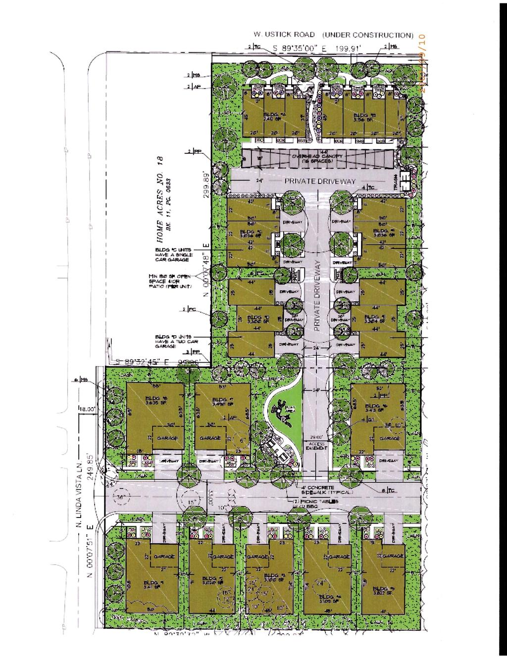
11 CAR , CUP & CVA Boise City Planning and Zoning Commission / September 10, /2 2 of Executive Summary Description of Applicant's Request: Larry and Barbara Woolf request approval of a rezone of ± 1.33 acres located at 9545 W. Ustick Rd. from R-1C (Single Family Residential with a maximum of 8.0 DU/acre) to R-2D (Combined Residential with a maximum of 14.5 DU/acre with Design Review). Along with the rezone is a request for approval of a Conditional Use Permit to construct a 27-unit planned residential development on ± 3.05 acres (inclusive of the ± 1.33 acres with the rezone request). The remaining acreage is in a R-1B zone (Single Family Residential with a maximum of 4.8 DU/acre). This proposal includes a variance request from the rear yard setback requirement. Staff's Recommendation: Staff recommends approval of CAR , CUP and CVA Summary: Staff finds the requested rezone to be in compliance with the goals, objectives and policies of the Comprehensive Plan and the Ustick Concept Master Plan. The portion of the property requested for rezoning is designated as Medium Density (15 Dwelling Units/Acre) on the Land Use Map. The R-2D zone is listed as an acceptable classification on the Land Use/Zoning Consistency Matrix and is consistent with the Land Use Designation of the Ustick Concept Master Plan. The requested zone would facilitate development that meets the community s vision for the area. The project will help minimize suburban sprawl while providing for a diverse mixture of lifestyles and atmospheres and a sense of place that varies (Goal 8.0). Policy requires that residential street scenes provide variety and modulation in design and placement of homes. The building designs have physically well-modulated façades and utilize a variety of building materials. The location of the proposed use is compatible with other uses in the general neighborhood. As mentioned previously, the Comprehensive Plan and the Neighborhood Plan both support the proposed density at this location. Further, the building designs are compatible with the existing neighborhood and adjoining properties in terms of height, bulk and site location. This project benefits the neighborhood and the City. Staff finds that the proposed use, if it complies with all conditions imposed, will not adversely affect other property of the vicinity. The proposed use is compatible to the neighborhood and that through the building design and landscaping the applicant has minimized any possible impacts to the adjacent properties. The attached recommended conditions of approval will ensure the project is built in compliance with the submitted plans. The applicant s request for a variance from the 30 rear yard setback to a 15 setback has merit. Even with the proposed 15 setback, the applicant is providing a greater setback than their neighbor. This is because the applicant s rear yard faces the neighbor s side yard, which has a 10 side yard setback requirement. The circumstance is unique, and the variance findings can be made.
12 CAR , CUP & CVA Boise City Planning and Zoning Commission / September 10, /2 3 of Facts, Standards of Review, and Analysis Type Application: The applicant requests the following: Rezone ± 1.33 acres from R-1C (Single Family Residential with a maximum of 8.0 DU/acre) to R-2D (Combined Residential with a maximum of 14.5 DU/acre with Design Review). Conditional Use Permit for 27-unit Planned Residential Development on ± 3.05 acres. That portion which is not being re-zoned is R-1B (Single Family Residential with a maximum of 4.8 DU/acre). Variance to the rear yard setback in the R-1B zone. Applicant/Status: Larry and Barbara Woolf / Owners Location and Site Description: The site is addressed at 9545 W. Ustick Rd. It is located near the southwest intersection of W. Ustick with N. Linda Vista Lane. The property is a backwards L shape with frontage on both Ustick and Linda Vista, but it does not sit at the intersection as there is other ownership at that location. The property lies within the boundaries of the West Bench Planning Area as designated on the Land Use Map of the Boise City Comprehensive Plan. It is also within the boundaries of the West Valley Neighborhood Association. Zoning, Zoning Allowances, and Comprehensive Plan Designation: The applicant is requesting R-2D (Combined Residential with Design Review) zoning for the northern portion of the project area. The Boise City Comprehensive Plan Land Use Map designates the northern portion of the site as Medium Density Residential (15 DU/acre). R-2D is a permissible zone within this designation. The southern portion of the project area is zoned R- 1B, and there is no rezone request for it. This southern portion of the site is designated as Low Density Residential (4 DU/acre) on the Boise City Comprehensive Plan Land Use Map. Planned Unit Developments are allowed in both the R-1B and the R-2D zones with conditional approval. History of Previous Actions: SUB is under concurrent review. Standards of Review Rezone Section AMENDMENT, RECLASSIFICATION Section Public Hearing The Planning and Zoning Commission shall advertise, provide notice and conduct a public hearing in accordance with Section of this Ordinance for each application to amend this Ordinance or to reclassify a zoning district.
13 CAR , CUP & CVA Boise City Planning and Zoning Commission / September 10, /2 4 of 21 Any recommendation of the Commission relating to change, modification and reclassification of zoning districts and land use classifications and the regulations and standards thereof shall be in writing. The recommendation shall include findings of fact supporting the purposes and objectives of zoning and otherwise securing public health, safety and general welfare. The recommendation shall specifically find that such changes, modifications and reclassifications of zoning districts and land use classifications and the regulations and the standards thereof: A. Comply with and conform to the Comprehensive Plan; and B. Provide and maintain sufficient transportation and other public facilities, and does not adversely impact the delivery of services by any political subdivision providing services. C. Maintain and preserve compatibility of surrounding zoning and development. Conditional Use Permit Section Conditional Use Permits Section Justification Conditional uses by definition possess characteristics such as to require review and appraisal by the Commission to determine whether or not the use would cause any damage, hazard, nuisance or other detriment to persons or property in the vicinity. Section Criteria and Findings The Commission, following the procedures outlined below, may approve a conditional use permit when the evidence presented at the hearing is such as to establish: A. That the location of the proposed use is compatible to other uses in the general neighborhood; and B. That the proposed use will not place an undue burden on transportation and other public facilities in the vicinity; and C. That the site is large enough to accommodate the proposed use and all yards, open spaces, pathways, walls and fences, parking, loading, landscaping and such other features as are required by this title; and D. That the proposed use, if it complies with all conditions imposed, will not adversely affect other property of the vicinity; and E. That the proposed use is in compliance with and supports the goals and objectives of the Comprehensive Plan.
14 CAR , CUP & CVA Boise City Planning and Zoning Commission / September 10, /2 5 of 21 Section Development Standards The Planning and Zoning Commission may approve planned unit developments in accordance with the following standards: A. Changes from the development standards of the underlying zone may be approved. For planned unit developments in the R-1M District, only minor changes consistent with the purpose of the R-1M zone may be approved. B. Planned Development Size: The minimum size for a planned development shall be as follows: 1) Planned residential development - no minimum. C. Residential Density: The number of dwelling units allowed in a planned development shall be calculated by dividing the gross area, less the area set aside for nonresidential uses (that is, office, commercial or industrial), by the minimum lot area per dwelling unit required by the zone in which the site is located. D. Amenities: Two or more of the following amenities shall be provided as part of each planned development greater than one (1) acres in size: 1. Energy conservation measures such as solar access with active solar heating or water heating capacity, or water conservation measures such as adherence to waterefficient landscaping principals including the use of drought-tolerant native and naturalized plants. 2. Private active recreational facilities such as a swimming pool, tennis court, or playground, picnic area, etc. of a size appropriate to meet the needs of the development. 3. Landscaped open space of at least 10% of gross area excluding required setbacks. 4. Provision for public access to or additions to the Boise River Greenbelt, neighborhood park system or other public open space. 5. A Class I public bicycle circulation system to connect to existing or planned routes on the periphery of the development. Such facilities shall be designed and constructed in accordance with The Bicycle Pedestrian Design Manual for Ada County. 6. Other amenities as approved by the Planning and Zoning Commission.
15 CAR , CUP & CVA Boise City Planning and Zoning Commission / September 10, /2 6 of 21 F. Required Setbacks: Attached structures may be permitted in planned developments. Along the periphery of planned developments, yards shall be provided as required by the regulations of the district in which the development is located unless the Commission provides an exception as provided for in Section Where development already exists at the periphery, the yards shall, where practical, be matched. For example, side yards should be provided adjacent to side yards, rear yards adjacent to rear yards and front yards opposite front yards. G. Service drive design and construction shall comply with the requirements of the Zoning Ordinance. Private street design and construction shall comply with the requirements of the Subdivision Ordinance. J. Compliance with the Micro-Pathway Regulations of the Boise City Code. K. Residential Uses: A variety of housing types or residential uses may be included in planned developments including attached units (duplexes, townhomes), detached units (patio homes), single family units (except mobile homes and stock manufactured homes, see section ), and multiple family units (triplexes, 4-plexes, 6-plexes, etc.) regardless of the zoning classification of the district, provided that the overall density of the zone is maintained. Duplexes reviewed as part of a planned development shall meet the design criteria of section Planned Developments; Developer Benefits D. Setbacks for buildings within the interior of the project may be less than required in the zoning district. Variance Section Action by the Commission The Commission must approve, approve conditionally, deny or modify the variance request. In acting upon such variance, the Commission shall review the findings of Staff and shall grant a variance upon finding that the following are true: A. That the granting of the variance will not be in conflict with the spirit and intent of the Comprehensive General Plan for the City, and will not effect a change in zoning. B. That there is either a hardship associated with the property itself or an exceptional circumstance relating to the intended use of the property, which is not generally applicable to property or permitted uses in the district.
16 CAR , CUP & CVA Boise City Planning and Zoning Commission / September 10, /2 7 of 21 C. The granting of such relief will not be materially detrimental to the public health, safety or welfare, or injurious to the property or improvements of other property owners, or the quiet enjoyment of such property or improvement. Analysis Rezone Larry and Barbara Woolf request approval to rezone ± 1.33 acres from R-1C (Single Family Residential with a maximum of 8.0 DU/acre) to R-2D (Combined Residential with a maximum of 14.5 DU/acre with Design Review). The current R-1C zone primarily allows for single-family residential uses. The proposed R-2 zone allows for denser residential uses, including multifamily. The purpose of the different residential classifications is to provide regulations supporting various districts within the urban community. Land may be classified to these zones in conformity with the goals and objectives of the Comprehensive Plan, for location, topographic or other reasonable purposes to guide the physical growth and stability of the City. The applicant proposes the R-2 zone in order to achieve a higher density. Staff finds that this rezone will comply with and conform to the Boise City Comprehensive Plan. Policy of the Boise City Comprehensive Plan indicates that zone change requests that are consistent with the Land Use/Zoning Consistency Matrix and the policies of the Boise City Comprehensive Plan should be approved by the City pursuant to appropriate findings related to service levels and other requirements of the Boise City Comprehensive Plan. This portion of the property is designated as Medium Density (15 Dwelling Units/Acre) on the Land Use Map. The vision for this land use designation is to support urban development with a target density of eight to fifteen dwelling units per acre with building designs of one, two and three stories. This includes townhouses, condominiums and apartments. Smaller lot sizes, and higher density may also be appropriate in certain cases. Both the current zoning of R-1C and the proposed zoning of R-2D is consistent with the Land Use Map designation for Medium Density. Given this re-zone, should this property redevelop in the future, uses other than the one currently under consideration are allowed in the R-2 zone. The R-2 zone allows the same uses as the R-1C zone, but also allows conditional uses that the R-1C zone does not. These include a boarding house, convalescent home, halfway house, or a mobile home park. It is unlikely that this property would re-develop into a mobile home park in the future, and the boarding house, convalescent home and halfway house could all be appropriate uses in this location. Further, because these are conditional uses in the R-2 zone, an application for such use would be reviewed by City staff. The rezone request is consistent with the guiding principles of the Ustick Neighborhood Plan, adopted by reference in the Boise City Comprehensive Plan. The plan indicates an interest in this site being zoned R-2. Neighborhood infill in this location should occur as defined, with densities appropriate to an R-2 zone. This project conforms with other goals, objectives and policies of the Comprehensive Plan. Objective seeks to ensure that growth is planned and directed in a way that minimizes
17 CAR , CUP & CVA Boise City Planning and Zoning Commission / September 10, /2 8 of 21 sprawl and creates a functional and pleasing community. Rezoning in this location allows greater density along a major roadway. Dense residential uses are typically located on the perimeter of residential neighborhoods, providing a transition from a busy roadway to lower density residential uses. This proposal is in line with this pattern by proposing a rezone to support denser multi-family housing along Ustick Rd. and transitioning to single-family housing at the southern portion of the project. By implementing this pattern, and applying for a rezone and a PUD, this project does help to reduce sprawl while creating a pleasant living environment. The rezone of the property will not adversely affect public services in the vicinity of the site. Policy of the Boise City Comprehensive Plan indicates that the City shall take into consideration the impact of the project on street levels of service. Staff finds the rezone will not place an undue burden on the transportation system in the vicinity. This was confirmed by the Ada County Highway District (ACHD) in a staff report dated August 10, 2007, and which is summarized in the Traffic Counts section found below. Finally, all other necessary infrastructure, such as water and sewer, is available. The proposed rezone will maintain and preserve the subject property s compatibility with surrounding zoning and development. Development to the north, across Ustick Rd., is a singlefamily subdivision in an R-1C zone. To the east consists of single-family residences in a R-1C zone to the north and a R-1B zone to the south. To the west are single-family residences at the northern half in a R-1C zone, and at the southern half across Linda Vista is multi-family housing in a R-1B zone. To the south is a single-family residence and a mobile home park in a R-1B zone. Surrounding zoning and development is primarily single-family residences, but there are also denser development types represented. This project fits into the context with denser attached residential development toward Ustick Road, transitioning to detached single-family toward the south of the project area. Conditional Use Along with the rezone is a request for approval of a Conditional Use Permit to construct a 27- unit planned residential development on ± 3.05 acres (inclusive of the ± 1.33 acres with the rezone request). The remaining acreage is in a R-1B zone (Single Family Residential with a maximum of 4.8 DU/acre). The location of the proposed use is compatible with other uses in the general neighborhood. The general area is transitioning from a semi-rural setting to a more urbanized environment, with residential subdivisions already existing to the north of Ustick Road. Projects to the north of Ustick are primarily single-family residential, and where development exists in closer proximity to this site on the south of Ustick, both attached and detached product types exist. This project will help the neighborhood develop as visioned. As mentioned previously, the Comprehensive Plan and the Neighborhood Plan both support the proposed density at this location. Further, the building designs are compatible with the existing neighborhood and adjoining properties in terms of height, bulk and site location. At the north, fronting Ustick, the proposed multi-family housing is 2 ½ stories high. Ustick is a broad and busy street, and homes this tall will help to frame the street and give the public streetscape a desirable character. The multi-family buildings in the middle of the project are 2 stories high, and provide a transitional area between the taller
18 CAR , CUP & CVA Boise City Planning and Zoning Commission / September 10, /2 9 of 21 buildings at the street and the single-family residential buildings proposed at the southern portion of the project. The height limit in both the proposed R-2 zone and the R-1B zone is 35. The proposed structures meet this requirement with the tallest buildings being 35 in height at the road, and stepping down to single family residential. Staff has not received indication from any public agency that the proposed development will place an undue burden on the services they provide. Findings from ACHD include the following: 1. Trip Generation: This development is estimated to generate 189 additional vehicle trips per day based on the Institute of Transportation Engineers Trip Generation Manual. 2. Impacted Roadways: Roadway Frontage Functional Classification N. Linda Vista 250 Local Lane Residential Traffic Count n/a Level of Service Planning threshold for local residential is up to 2,000 VTD W. Ustick Rd. 200 Minor Arterial* 18,835 west of Better than Mitchell St. on C 11/15/2006 * Acceptable level of service for a five-lane Minor Arterial Roadway is D (33,000 VTD). Speed Limit 25 MPH 35 MPH Other agencies were transmitted copies of this project, and have not indicated any undue burden on the services they provide. The site is large enough to accommodate the proposed use and all elements as required. The density of the development is meeting the requirements of the underlying zones, and the re-zone request fulfills the vision for the area. The number of units proposed fits onto the site well. The applicant is meeting setback requirements for the zone, except for the variance request at the southern edge of the project area, which will be addressed in a separate section of this report. Residential planned unit developments on more than 1 acre are required to provide 2 amenities. This project provides a common lot with picnic tables and a play area. Two off-street parking spaces must be provided per unit, and this project meets that requirement. While some units have a single-car garage, they also provide a second parking space on the concrete apron to the garage. Overall, this project provides 54 parking spaces, plus 30 spaces are available for guest parking. Staff finds that the proposed use, if it complies with all conditions imposed, will not adversely affect other property of the vicinity. The proposed use is compatible to the neighborhood and that through the building design and landscaping the applicant has minimized any possible
19 CAR , CUP & CVA Boise City Planning and Zoning Commission / September 10, /2 10 of 21 impacts to the adjacent properties. The attached recommended conditions of approval will ensure the project is built in compliance with the submitted plans. The proposed use is in compliance with the Boise City Comprehensive Plan. The project will help minimize suburban sprawl while providing for a diverse mixture of lifestyles and atmospheres and a sense of place that varies (Goal 8.0). Policy requires that residential street scenes provide variety and modulation in design and placement of homes. Facing Ustick, the basic building design has a physically well-modulated façade and utilizes a variety of building materials. This is also true of the facades internal to the project. There are a variety of architectural styles present in this project, and staff finds that this policy has been acted upon. Further, the project supports the neighborhood vision for the area by providing public sidewalks and street trees to create a pedestrian friendly environment. The only difference is that the neighborhood plan calls for street trees to be placed between the curb and sidewalk. Staff finds that this is not possible on Ustick, which ACHD has just finished improving, but that it should be possible on Linda Vista. A condition of approval will require that street trees on Linda Vista be planted between curb and sidewalk. Connectivity & Sidewalk Design: Access to the site has been provided via a public road running east/west from Linda Vista, and a private drive running north/south continues access to the remainder of the project area. The east/west public road stubs to the eastern edge of the parcel, allowing access opportunities for future development. Sidewalk is already available along Ustick, and is proposed along Linda Vista, as well as along the public road and private drive interior to this project, contributing to the pedestrian connectivity in this neighborhood. Variance This proposal includes a variance request from the rear yard setback requirement. The granting of the variances will not be in conflict with the spirit and intent of the Boise City Comprehensive Plan. Policy requires that all new residential development in existing neighborhoods be compatible with existing structures, including setbacks. Regarding the rear yard setback, the applicant s request for a variance from the 30 setback to a 15 setback has merit. Even with the proposed 15 setback, the applicant is providing a greater setback on their side of the property line than is required for their neighbor. This is because the neighbor presents their side yard, which is required to have a 10 setback, to the shared property line. Staff finds that the proposed development is compatible with the existing structures and setbacks. Staff is able to identify an exceptional circumstance relating to the intended use of the property which is not generally applicable to property or permitted uses in the district. The neighboring property that could be affected by this variance consists of a single-family residence that presents its side yard to the project area. A previously discussed, the side yard setback in the R-1B zone is 10, and the applicant is proposing a 15 rear yard setback along this shared property line. Staff finds granting the requested variance is reasonable. The granting of this variance will not be materially detrimental to the public health, safety or welfare, nor injurious to the property or improvements of other property owners, or the quiet
20 CAR , CUP & CVA Boise City Planning and Zoning Commission / September 10, /2 11 of 21 enjoyment of such property or improvement. Staff would like to note that there is no public opposition to this project on record. 3. Reasons for the Decision Rezone Staff finds the requested rezone to be in compliance with the goals, objectives and policies of the Comprehensive Plan and the Ustick Concept Master Plan. The requested zone would facilitate development that meets the community s vision for the area. The rezone of the property will not adversely affect public services in the vicinity of the site. Staff finds the rezone will not place an undue burden on the transportation system in the vicinity. All other necessary infrastructure, such as water and sewer, is available. The proposed rezone will maintain and preserve the subject property s compatibility with surrounding zoning and development. Surrounding zoning and development is primarily singlefamily residences, but there are also denser development types represented. This project fits into the context with denser attached residential development toward Ustick Road, transitioning to detached single-family toward the south of the project area. Conditional Use and Variance The location of the proposed use is compatible with other uses in the general neighborhood. As mentioned previously, the Comprehensive Plan and the Neighborhood Plan both support the proposed density at this location. Further, the building designs are compatible with the existing neighborhood and adjoining properties in terms of height, bulk and site location. This project benefits the neighborhood and the City. The site is large enough to accommodate the proposed use without adversely affecting other property in the vicinity. All required parking spaces have been provided, and the minimum amenities included. Comments received from public agencies confirm the project will not place an undue burden on the services they provide. Traffic counts confirm the local and arterial roadways will continue to operate at an acceptable level of service. Staff finds that the proposed use, if it complies with all conditions imposed, will not adversely affect other property of the vicinity. The proposed use is compatible to the neighborhood and that through the building design and landscaping the applicant has minimized any possible impacts to the adjacent properties. The attached recommended conditions of approval will ensure the project is built in compliance with the submitted plans. The proposed use is in compliance with the Boise City Comprehensive Plan. The project will help minimize suburban sprawl while providing for a diverse mixture of lifestyles and atmospheres and a sense of place that varies (Goal 8.0). Policy requires that residential
21 CAR , CUP & CVA Boise City Planning and Zoning Commission / September 10, /2 12 of 21 street scenes provide variety and modulation in design and placement of homes. The building designs have physically well-modulated façades and utilize a variety of building materials. The applicant s request for a variance from the 30 rear yard setback to a 15 setback has merit. Even with the proposed 15 setback, the applicant is providing a greater setback than their neighbor. This is because the applicant s rear yard faces the neighbor s side yard, which has a 10 side yard setback requirement. The circumstance is unique, and the variance findings can be made. 4. General Information Notifications: Neighborhood Meeting held on: April 24, 2007 Newspaper notification published on: July 21, 2007 Radius notices mailed to properties within 300 feet on: July 20, 2007 Staff posted notice on site on: July 18, 2007 Size of Property: ± 3.05 Acres Existing Land Use: Staff observed one single-family structure on site. Aerial photos, dated 2003, indicate approximately six structures on site. Hazards: Ustick Road is a busy arterial roadway. Adjacent Land Uses and Zoning: North: Single-Family Residences / R-1C (Single-Family Residential) South: Single-Family Residences / R-1B (Single-Family Residential) East: Single-Family Residences / R-1B & R-1C (Single-Family Residential) West: Single-Family Residences / R-1B & R-1C (Single-Family Residential) Perimeter Setbacks: Yard R-1B Building & Parking R-2D Building & Parking Required Proposed Required Proposed Front N/A N/A Street Side N/A N/A Interior Side Rear * N/A N/A * A variance is being sought for the proposed encroachment into the rear yard setback.
22 CAR , CUP & CVA Boise City Planning and Zoning Commission / September 10, /2 13 of 21 Density: Allowed in the R-2D zone: Proposed in the R-2D zone: Allowed in the R-1B zone: Proposed in the R-1B zone: 14.5 DU / acre, or DU / 1.33 acres DU / 1.33 acres 4.8 DU / acre, or 8.26 DU / 1.72 acres 8.00 DU / 1.72 acres Parking Required: 2 off-street spaces / unit Proposed: 2 off-street spaces / unit = 54 spaces, plus 30 spaces for guest parking 5. Boise City Comprehensive Plan This project is located in the West Bench Planning Area. There are no goals, objectives or policies for this planning area that specifically apply to this application. Additional Boise City Comprehensive Plan Goals, Objectives and Policies CHAPTER 6 TRANSPORTATION Policy When reviewing land use amendments, zone changes, master plans, conditional uses and other significant entitlement requests, the City shall take into consideration the impact of the project on street levels of service. The City s preferred standards shall be those identified for new streets in ACHD s Development Policy manual, or its successor. Service level impacts shall be minimized through project modifications, traffic management plans, street improvement plans or other means. Policy New developments shall be required to stub access to adjacent undeveloped parcels, where appropriate. Policy All new development shall be reviewed for appropriate opportunities to connect to local roads and collectors in adjacent developments. Policy Limit access to all arterial streets. Policy Develop methods, such as cross-access agreements, frontage and backage roads, to reduce the number of existing access points onto arterial streets.
23 CAR , CUP & CVA Boise City Planning and Zoning Commission / September 10, /2 14 of 21 CHAPTER 7 COMMUNITY QUALITY Policy Recognize that size of structures is a component of design in appropriate cases. Policy Require that multifamily residential projects be designed to convey a high level of quality and distinctive neighborhood character in accordance with the Design Guidelines and the following policies: a) Require modulated building elevations to minimize the visual character of singular building mass and volume. b) Include separate and well-defined entries to convey individual identity for each residential unit, which may be accessed from exterior/interior courtyards and/or common areas. c) Integrate siting and design of parking areas and facilities with the architectural character of the structure and ensure they do not dominate the character of the structure. Policy Require that private and public open space be incorporated in new multifamily developments and that they are accessible and large enough to be used by all residents. Downtown high rise developments may be exempted from this requirement. Policy Require that residential street scenes provide variety and modulation in design and placement of homes. Policy Require that all new residential development in existing residential neighborhoods (i.e., infill) be compatible with existing structures, including the following criteria: a) Use of complimentary setbacks, building heights, grade elevations, orientation, bulk, building materials, colors and forms, while allowing flexibility for distinctive design solutions; b) Maintenance of privacy. Policy Pursue a variety of strategies and programs to prevent disinvestment from occurring in the older parts of the community, including but not limited to: promotion of home ownership and a variety of housing opportunities, protection of neighborhood character and maintenance of high quality services and public facilities. Policy In order to better connect neighborhoods, require that street configurations involve the interconnection of individual streets.
24 CAR , CUP & CVA Boise City Planning and Zoning Commission / September 10, /2 15 of 21 Policy Establish a continuous network of sidewalks, bicycle and/ or pedestrian paths to establish internal and external linkage within the community. CHAPTER 8 LAND USE Policy The Land Use/Zoning Consistency Matrix shall identify the zoning districts that are permissible within each land-use designation. Conformance with the Land Use/Zoning Consistency Matrix shall be a necessary finding of approval for all zone changes and conditional uses, unless one or more of the forms of flexibility identified in the policies under Objective 2 are implemented. Land Use / Zoning Consistency Matrix (excerpt from) Land Use A R-1A R-1B R-1C R-1M R-2 R-3 N-O L-O PC Medium Density Residential 15 X X X X X X X X X Low Density Residential 4 X X X X X X Policy Zone change requests that are consistent with the Land Use/Zoning Consistency Matrix and the policies of the Boise City Comprehensive Plan should be approved by the City pursuant to appropriate findings related to service levels and other requirements of the Boise City Comprehensive Plan. Table Definitions of Land Use Map Designations Land Use Applies To Allowed Uses and/or Limitations Medium Density Residential 15 Townhouses, condominiums, apartments 8 to 15 units per gross acre. Building designs may have one-, two- and three-story elements. Surface parking may be sufficient to accommodate density. Low Density Residential 4 Standard urban low-density category applies to widest area of existing singlefamily developments. 6,000 square foot lots, overall target density of 4 units per gross acre. PUDs, accessory units and application of infill standards may allow higher densities on specific projects.
25 CAR , CUP & CVA Boise City Planning and Zoning Commission / September 10, /2 16 of 21 CHAPTER 10 GROWTH MANAGEMENT Goal 10.1 Preserve, protect and enhance the overall quality of life in Boise and its Area of Impact by ensuring that growth occurs in an orderly manner and that public services are available along with development. Objective Ensure that growth is planned and directed in a way that minimizes sprawl and creates a functional and pleasing community. 6. Boise City Zoning Ordinance Section PURPOSE OF R-1A, R-1B AND R-1C DISTRICTS It is the purpose of the R-1A, R-1B and R-1C District Classifications to provide various regulations and districts for predominantly single family residential uses within the urban community. Land may be classified to these respective classifications in conformity with the goals and objectives of the Comprehensive General Plan, for location, topographic or other reasonable purposes to guide the physical growth and stability of the City. Section PURPOSE OF THE R-2 DISTRICT CLASSIFICATION It is the purpose of the R-2 District classification to accommodate a need for medium density residential zones within the City. Land may be classified R-2 in conformity with the goals and objectives of the Comprehensive General Plan to create medium density residential zones on the periphery of more intensive land use areas, to intersperse in the R-2 District limited garden type apartments and in some selected areas, upon City approval, permit quasi-residential uses as well as for the purpose of creating balanced residential zoning patterns within the City. Section PURPOSE OF D, HD AND DD DISTRICTS "D", "HD" and "DD" districts are established to insure that the general appearance of the development on the land shall not be in conflict with the Boise City Comprehensive Plan or other development plans adopted by Boise City for specific areas. It shall be the further purpose of this act to protect property rights and values, enhance important environmental features of the City and the physical characteristics of the land; and further to insure that the general appearance of buildings and structures, and the development of land, shall not impair or preclude the orderly and harmonious development of the community. To accomplish said objectives, it shall be the further purpose of this act to coordinate design input from other jurisdictions, to regulate landscaping, to review building design, site planning, signs grading, development and beautification, including but not limited to the regulation and restriction of the type, number of stories, size, construction, reconstruction, alteration, repair or use of buildings and structures to insure compliance with the requirements of the respective use district with which the "D", "HD" and "DD" district is combined.
26 CAR , CUP & CVA Boise City Planning and Zoning Commission / September 10, /2 17 of 21 Section GENERAL STANDARDS Section CONDITIONAL USE PERMITS Section AMENDMENT, RECLASSIFICATION Section PLANNED DEVELOPMENTS Section DEVELOPMENT STANDARDS Section VARIANCES Section GENERAL PROVISIONS Section PUBLIC AND PRIVATE PARKING AREAS Section OFF-STREET PARKING REQUIREMENTS 7. Recommended Conditions of Approval Site Specific: 1. Construction, use and property development shall be in compliance with plans and specifications on file with the Boise City Planning and Development Services Department received on June 26, 2007 and revised on August 20, 2007, except as may be modified by the following conditions. 2. Shade trees shall be planted between curb and sidewalk on Linda Vista. 3. The applicant shall comply with the requirements of the Boise City Public Works Department (BCPW) per Department comments dated July 10, All items required by BCPW shall be included on the plans/specifications that are submitted for a Building Permit. Please note that any changes or modifications by the owner to the approved plans must be submitted to the Public Works Department for approval. 4. Comply with all conditions of the Ada County Highway District as required in the staff report dated August 10, Comply with all conditions of the Boise City Fire Department, as required the memo dated July 24, 2007.
27 CAR , CUP & CVA Boise City Planning and Zoning Commission / September 10, /2 18 of Comply with all conditions of the Boise Independent School District, as required the letter dated July 11, General: 7. No change in the terms and conditions of this approval shall be valid unless in writing and signed by the applicant or his authorized representative, and an authorized representative of the City of Boise. The burden shall be upon the applicant to obtain the written confirmation of any change and not upon the City of Boise. 8. Any change by the applicant in the planned use of the property which is the subject of this application, shall require the applicant to comply with all rules, regulations, ordinances, plans, or other regulatory and legal restrictions in force at the time the applicant or its successors in interest advises the City of its intent to change the planned use of the property described herein unless a variance in said requirements or other legal relief is granted pursuant to the law in effect at the time the change in use is sought. 9. An Occupancy Permit will not be issued by the Building Department until all of these condition(s) have been complied with. In the event a condition(s) cannot be met by desired date of occupancy, the Planning Director will determine whether the condition(s) is bondable or should be completed, and if determined to be bondable, a bond will be required in the amount of 110% of the value of the condition(s) which are incomplete. 10. Vision Triangles as defined in Section and Section G. of the Boise City Zoning Ordinance shall remain clear of all sight obstructions. 11. Development on the site shall not obstruct the flow of water through any irrigation ditches on or adjacent to the site. If any watercourse is to be altered, written approval shall be obtained from the appropriate agency. 12. A detailed grading and drainage plan shall be submitted for review and approval by the Ada County Highway District and Boise City Public Works Department before a Building Permit is issued. 13. The applicant or his/her contractor shall obtain a Right-of-Way Permit from the Ada County Highway District prior to any construction in the public right-of-way. 14. Hook-up to wet line sewers shall be required prior to issuance of an Occupancy Permit. 15. Utility services shall be provided underground. 16. All landscaping shall be maintained in a healthy and attractive condition, irrigated by an appropriate underground irrigation system.
28 CAR , CUP & CVA Boise City Planning and Zoning Commission / September 10, /2 19 of Exterior lighting fixtures must be designed and located so as to prevent glare or direct light from falling onto adjoining properties or streets. 18. Any future division of this parcel into individual lots or parcels, for the purpose of selling the separate lots to individual owners, will be required to comply with all provisions of Boise City Code, Title 9, Chapter 20, including lot frontage on a public or approved private street, and all requirements for preliminary and final platting. 19. Construction, use and property development shall be in conformance with all applicable requirements of the Boise City Code. 20. The applicant shall obtain Building Permits prior to any work commencing on the property. 21. Specific building construction requirements of the International Building Code and Uniform Fire Code will apply. However, these provisions are best addressed at Building Permit application. 22. Failure to abide by any condition of this Conditional Use Permit shall be grounds for revocation by the Boise City Planning and Zoning Commission. 23. This Conditional Use shall be valid for a period not to exceed eighteen (18) months from the date of approval by the Planning and Zoning Commission. Within this period, the holder of the permit must: a. Acquire construction permits and commence placement of permanent footings and structures on or in the ground. The definition of structures in this context shall include sewer lines, water lines, or building foundations; or b. For projects that require platting, the plat must be recorded within this period. The Commission may also fix the time or period within which the permit shall be completed, perfected or bonded. If the conditions of approval shall not be completed or bonded within such period, said permit shall lapse. 24. Prior to the expiration of this conditional use, the Commission may, upon written request by the holder, grant a one-year time extension. A maximum of three (3) extensions may be granted. 25. All development authorized by this Conditional Use approval must be completed within 5 years (60 months) from the date of the Commission's approval or the applicant will be required to submit a new conditional use application.
29 CAR , CUP & CVA Boise City Planning and Zoning Commission / September 10, /2 20 of 21 Construction Site Practices: 26. The practices required below are intended to mitigate the impact and disturbance of residential property owners during the construction of adjacent buildings or structures. The following conditions apply to all construction-related activities ranging from grading and demolition activities to final occupancy on any land or parcel falling under the proprietary ownership of the permit applicant. a) Prior to the issuance of a building permit and prior to the commencement of any construction on-site, an Erosion and Sediment Control (ESC ) permit must be obtained from the Planning and Development Services Department. No grading, demolition or earth disturbing activities may start until an approved ESC permit and the associated site work or grading permits have been issued. b) Applicant shall submit and receive approval from Planning and Development Services and Ada County Highway District for a construction, transportation and parking plan. The plan shall also comply with all construction standards of Ada County Highway District to those streets contiguous to the construction site and surrounding neighborhood. The approved plan shall be posted at each street abutting the construction site and shall address the following: Ingress/egress of construction equipment and trucks; Hours of operation for the loading and unloading of construction equipment and materials; Truck access routes, to and from site, for excavation and construction phases; Street closures (if any); and Location of off street parking for construction workers. c) Measures shall be taken to manage construction debris and trash on the construction site and efforts shall also be made to provide reasonable controls to minimize fugitive dust on the construction site. Such measures may include, but are not limited to: Provide suitable containers for solid waste generated by construction activity; Wet demolition of existing buildings; Watering of driving surfaces and earth moving activities; Installation of wind screening around property and each open floor above grade; and Daily broom cleaning of above grade floors, adjacent streets and sidewalks. d) To reduce the noise impact of construction on nearby residential properties, all exterior construction activities shall be limited to the hours between 7:00 a.m. and 7:00 p.m. Monday through Friday and 8:00 a.m. to 6:00 p.m. for Saturday and Sunday. Low noise impact activities such as surveying, layout and weather protection may be performed at any time. After each floor of the structure or building is enclosed with exterior walls and windows, interior construction of the enclosed floors can be performed at any time.
30 CAR , CUP & CVA Boise City Planning and Zoning Commission / September 10, /2 21 of 21 e) A minimum height of six foot (6 ) rigid security fencing, either wood or metal, shall be installed around the construction site within 30 days of the date when the first city permit is issued on projects where construction activity shall exceed 90 days. f) Exterior lighting and other illuminating equipment or materials shall be positioned, shielded, directed and located to not reflect or impact adjacent residential property and streets. g) Applicant shall comply with Boise City Fire Department requirements for water, access, and/or other requirements as determined by the Fire Marshal. Any conditions to be enforced during construction shall remain posted at each street abutting the construction site for the duration of the project. In addition to the posted conditions the permit holder shall also post an 11 x 17 laminated sign containing a project contact phone number, name of project contact and the Boise City contact number, , to address issues as they arise. Failure to abide by any conditions set forth shall be grounds for revocation of Conditional Use Permit and/or Building Permits and may be subject the owner or owner s agents to fines and criminal citations.
31

32
33
34
35
36
37
38
39
40
41
42
43
44
45
46
47

48

49
50
51

52
53
54
55
56
57
58
59
60
61
62
63
64
65
66

67

68
RE: CAR / 4280 N.
 MEMORANDUM TO: FROM: Mayor and Boise City Council Hal Simmons - Planning Director Boise City Planning and Development Services DATE: April 29, 2009 RE: CAR09-00006 / 4280 N. Eagle Road The following application
Planning Director Boise City Planning and Development Services Department. CUP (Adoption of Findings & Revised Conditions of Approval)
") MEMORANDUM TO: FROM: Mayor and Boise City Council Hal Simmons Planning Director Boise City Planning and Development Services Department DATE: May 19, 2006 RE: CUP05-00172 (Adoption of Findings & Revised
MEMORANDUM TO: FROM: Mayor and Boise City Council Hal Simmons Planning Director Boise City Planning and Development Services Department DATE: May 19, 2006 RE: CUP05-00172 (Adoption of Findings & Revised
Hal Simmons Planning Director Boise City Planning and Development Services. CAR / 1689 South Entertainment Avenue
 MEMORANDUM MEMO TO: FROM: Mayor and Boise City Council Hal Simmons Planning Director Boise City Planning and Development Services DATE: November 15, 2008 RE: CAR08-00019 / 1689 South Entertainment Avenue
DEVELOPMENT DEPARTMENT STAFF REPORT THE PARK AT 5 TH
 DEVELOPMENT DEPARTMENT STAFF REPORT ARB Meeting Date: July 3, 2018 Item #: _PZ2018-293_ THE PARK AT 5 TH Request: Site Address: Project Name: Parcel Number: Applicant: Proposed Development: Current Zoning:
May we also take this opportunity to inform you of the following:
 September 15, 2009 Curtis Stigers & Amy O Brien Boise, ID 83702 Re: CVA09-00029 / Dear Mr. Stigers & Ms. O Brien: This letter is to inform you of the action taken by the Boise City Planning and Zoning
Planning Director Boise City Planning and Development Services Department. RE: CAR / DA: Rezone & Development Agreement / 6401 S.
 MEMORANDUM TO: FROM: Mayor and Boise City Council Hal Simmons Planning Director Boise City Planning and Development Services Department DATE: May 22, 2006 RE: CAR06-00019/ DA: Rezone & Development Agreement
AAAA. Planning and Zoning Staff Report Lake Shore Land Holdings, LLC CU-PH Analysis
 AAAA Planning and Zoning Staff Report Lake Shore Land Holdings, LLC CU-PH2016-28 Hearing Date: April 21, 2016 Development Services Department Applicant: BRS Architects/Cindy Huebert Staff: Kyle McCormick,
DEVELOPMENT DEPARTMENT STAFF REPORT STAFF REPORT DRESDEN DRIVE TOWNHOMES DCI
 DEVELOPMENT DEPARTMENT STAFF REPORT Meeting Date: September 13, 2018 Item #: PZ2018-319 STAFF REPORT DRESDEN DRIVE TOWNHOMES DCI Request: Project Name: Development of Community Compact (DCI) and six concurrent
ARTICLE 3: Zone Districts
 ARTICLE 3: Zone Districts... 3-1 17.3.1: General...3-1 17.3.1.1: Purpose and Intent... 3-1 17.3.2: Districts and Maps...3-1 17.3.2.1: Applicability... 3-1 17.3.2.2: Creation of Districts... 3-1 17.3.2.3:
CVA Robert and Renate Bearden
 CVA15-00016 Robert and Renate Bearden Summary Variance to reduce the rear yard setback for a carport located along the alley at 1811 S. Pacific Street in an R-1C (Single Family Residential) zone. Prepared
6. RESIDENTIAL ZONE REGULATIONS
 6. RESIDENTIAL ZONE REGULATIONS PART 6A PURPOSE OF CHAPTER (1) The purpose of this Chapter is to provide detailed regulations and requirements that are relevant only to residential zones and specific residential
The following application has been scheduled for hearing by the Boise City Council on February 15, 2011:
 MEMORANDUM TO: FROM: Mayor and City Council David Abo, AICP Chief Subdivision Review Analyst Boise City Planning and Development Services DATE: February 8, 2011 The following application has been scheduled
8.5.1 R1, Single Detached Residential District
 8.5.1 R1, Single Detached Residential District The purpose of this district is to provide for residential development in the form of single detached dwellings. Dwelling, Single Detached Home Business,
PLANNED UNIT DEVELOPMENT & SUBDIVISION STAFF REPORT Date: April 18, 2019
 PLANNED UNIT DEVELOPMENT & SUBDIVISION STAFF REPORT Date: April 18, 2019 DEVELOPMENT NAME SUBDIVISION NAME Springhill Village Subdivision Springhill Village Subdivision LOCATION 4350, 4354, 4356, 4358,
Subdivision Staff Report
 Subdivision Staff Report Subdivision Name Sunnyridge Subdivision File Number SUB07-00007 Approval Preliminary Plat Lead Agency Ada County Annexation Date NA Comp. Plan Complies (With Conditions of Approval)
The following regulations shall apply in the R-E District:
 "R-E" RESIDENTIAL ESTATE DISTRICT (8/06) The following regulations shall apply in the R-E District: 1. Uses Permitted: The following uses are permitted. A Zoning Certificate may be required as provided
Town of Cary, North Carolina Rezoning Staff Report 12-REZ-27 Morris Branch Town Council Public Hearing January 24, 2013
 Town of Cary, North Carolina Rezoning Staff Report 12-REZ-27 Morris Branch Town Council Public Hearing January 24, 2013 REQUEST To amend the Town of Cary Official Zoning Map to rezone approximately 9.0
Midwest City, Oklahoma Zoning Ordinance
 2010 Midwest City, Oklahoma Zoning Ordinance 9/2/2010 Table of Contents Section 1. General Provisions... 5 1.1. Citation... 5 1.2. Authority... 5 1.3. Purpose... 5 1.4. Nature and Application... 5 1.5.
ARTICLE XI CONDITIONAL USE PERMITS
 ARTICLE XI CONDITIONAL USE PERMITS 11.1 Purpose. The City of Hailey recognizes that certain uses possess unique and special characteristics with respect to their location, design, size, method of operation,
Implementation. Approved Master Plan and SMA for Henson Creek-South Potomac 103
 Implementation Approved Master Plan and SMA for Henson Creek-South Potomac 103 104 Approved Master Plan and SMA for Henson Creek-South Potomac Sectional Map Amendment The land use recommendations in the
ZONING ORDINANCE: OPEN SPACE COMMUNITY. Hamburg Township, MI
 ZONING ORDINANCE: OPEN SPACE COMMUNITY Hamburg Township, MI ARTICLE 14.00 OPEN SPACE COMMUNITY (Adopted 1/16/92) Section 14.1. Intent It is the intent of this Article to offer an alternative to traditional
Planned Unit Development (PUD). Sections:
. Sections:") Chapter 19.07. Planned Unit Development (PUD). Sections: 19.07.01. Purpose. 19.07.02. PUD Definition and Design Compatibility. 19.07.03. General PUD Standards. 19.07.04. Underlying Zones. 19.07.05. Permitted
Chapter 19.07. Planned Unit Development (PUD). Sections: 19.07.01. Purpose. 19.07.02. PUD Definition and Design Compatibility. 19.07.03. General PUD Standards. 19.07.04. Underlying Zones. 19.07.05. Permitted
Time Extension Staff Report
 Time Extension Staff Report Subdivision Name Lunara Subdivision File Number SUB07-00019 Approval Time Extension for Lead Agency Boise City Certification Signature of Boise City Engineer Annexation Date
ARTICLE 14 PLANNED UNIT DEVELOPMENT (PUD) DISTRICT
 DISTRICT") ARTICLE 14 PLANNED UNIT DEVELOPMENT (PUD) DISTRICT Section 14.01 Intent. It is the intent of this Article to allow the use of the planned unit development (PUD) process, as authorized by the Michigan Zoning
ARTICLE 14 PLANNED UNIT DEVELOPMENT (PUD) DISTRICT Section 14.01 Intent. It is the intent of this Article to allow the use of the planned unit development (PUD) process, as authorized by the Michigan Zoning
Town of Cary, North Carolina Rezoning Staff Report 14-REZ-31 Cary Park PDD Amendment (Waterford II) Town Council Meeting January 15, 2015
 Town Council Meeting January 15, 2015") Town of Cary, North Carolina Rezoning Staff Report 14-REZ-31 Cary Park PDD Amendment (Waterford II) Town Council Meeting January 15, 2015 REQUEST To amend the Town of Cary Official Zoning Map by amending
Town of Cary, North Carolina Rezoning Staff Report 14-REZ-31 Cary Park PDD Amendment (Waterford II) Town Council Meeting January 15, 2015 REQUEST To amend the Town of Cary Official Zoning Map by amending
CHAPTER 14 PLANNED UNIT DEVELOPMENTS
 9-14-1 9-14-1 CHAPTER 14 PLANNED UNIT DEVELOPMENTS SECTION: 9-14-1: Purpose 9-14-2: Governing Provisions 9-14-3: Minimum Area 9-14-4: Uses Permitted 9-14-5: Common Open Space 9-14-6: Utility Requirements
REPORT OF THE PLANNING AND DEVELOPMENT DEPARTMENT FOR APPLICATION FOR REZONING ORDINANCE TO PLANNED UNIT DEVELOPMENT SEPTEMBER 22, 2016
 BEL REPORT OF THE PLANNING AND DEVELOPMENT DEPARTMENT FOR APPLICATION FOR REZONING ORDINANCE 2016-576 TO PLANNED UNIT DEVELOPMENT SEPTEMBER 22, 2016 The Planning and Development Department hereby forwards
ARTICLE B ZONING DISTRICTS
 ARTICLE B ZONING DISTRICTS Sec. 8-3021 Established. In order to protect the character of existing neighborhoods; to prevent excessive density of population in areas which are not adequately served with
LAND USE AND ZONING OVERVIEW
 OVERVIEW OF PLANNING POLICIES LAND USE AND ZONING OVERVIEW The Minneapolis Plan for Sustainable Growth and Other Adopted Plans Community Planning and Economic Development Development Services Division
SUBJECT: Application for Planned Unit Development and Rezoning 1725 Winnetka Road
 TO: FROM: CHAIRMAN BILL VASELOPULOS AND MEMBERS OF THE PLAN & ZONING COMMISSION STEVE GUTIERREZ DIRECTOR OF COMMUNITY DEVELOPMENT MEETING DATE: September 5, 2017 SUBJECT: Application for Planned Unit Development
Staff Report PLANNED DEVELOPMENT. Salt Lake City Planning Commission. From: Lauren Parisi, Associate Planner; Date: December 14, 2016
 Staff Report PLANNING DIVISION COMMUNITY & NEIGHBORHOODS To: Salt Lake City Planning Commission From: Lauren Parisi, Associate Planner; 801-535-7932 Date: December 14, 2016 Re: 1611 South 1600 East PLANNED
RP-2, RP-3, RP-4, AND RP-5 PLANNED RESIDENTIAL DISTRICTS
 6.10 - RP-2, RP-3, RP-4, AND RP-5 PLANNED RESIDENTIAL DISTRICTS 6.10.1 GENERAL DESCRIPTION: 6.10.1.1 The regulations established in this Section are intended to provide optional methods of land development
SECTION 7000 LAND DEVELOPMENT REQUIREMENTS
 SECTION 7000 LAND DEVELOPMENT REQUIREMENTS 7000 LAND DEVELOPMENT REQUIREMENTS... 1 7001 LEGISLATIVE AUTHORITY... 1 7001.1 LAND DEVELOPMENT... 1 7001.1.1 Title 40, Idaho Code... 1 7001.1.2 Idaho Code 40-1415
3.1. OBJECTIVES FOR RESIDENTIAL LAND USE DESIGNATIONS GENERAL OBJECTIVES FOR ALL RESIDENTIAL DESIGNATIONS
 3. RESIDENTIAL LAND USE DESIGNATIONS INTRODUCTION The Residential land use designations provide for housing and other land uses that are integral to, and supportive of, a residential environment. Housing
Article 3. SUBURBAN (S-) NEIGHBORHOOD CONTEXT
 NEIGHBORHOOD CONTEXT") Article 3. SUBURBAN (S-) NEIGHBORHOOD CONTEXT this page left intentionally blank Contents ARTICLE 3. SUBURBAN (S-) NEIGHBORHOOD CONTEXT DIVISION 3.1 NEIGHBORHOOD CONTEXT DESCRIPTION...3.1-1 Section 3.1.1
Article 3. SUBURBAN (S-) NEIGHBORHOOD CONTEXT this page left intentionally blank Contents ARTICLE 3. SUBURBAN (S-) NEIGHBORHOOD CONTEXT DIVISION 3.1 NEIGHBORHOOD CONTEXT DESCRIPTION...3.1-1 Section 3.1.1
13 Sectional Map Amendment
 13 Sectional Map Amendment Introduction This chapter reviews land use and zoning policies and practices in Prince George s County and presents the proposed zoning in the sectional map amendment (SMA) to
RESIDENTIAL DISTRICTS
 RESIDENTIAL DISTRICTS RESIDENTIAL DISTRICTS The residential district standards have been revised to reflect on-the-ground development conditions, while continuing to respect the use patterns established
HOUSING ELEMENT GOALS, OBJECTIVES, & POLICIES
 HOUSING ELEMENT GOALS, OBJECTIVES, & POLICIES GOAL H-1: ENSURE THE PROVISION OF SAFE, AFFORDABLE, AND ADEQUATE HOUSING FOR ALL CURRENT AND FUTURE RESIDENTS OF WALTON COUNTY. Objective H-1.1: Develop a
ARTICLE VII. NONCONFORMITIES. Section 700. Purpose.
 ARTICLE VII. NONCONFORMITIES. Section 700. Purpose. The purpose of this chapter is to regulate and limit the development and continued existence of legal uses, structures, lots, and signs established either
ZONING AMENDMENT, SUBDIVISION & SIDEWALK WAIVER REQUEST STAFF REPORT Date: November 16, 2006
 ZONING AMENDMENT, SUBDIVISION & SIDEWALK WAIVER REQUEST STAFF REPORT Date: November 16, 2006 NAME SUBDIVISION NAME Terhaar & Cronley Investment Partnership P & E Subdivision LOCATION 4210 and 4218 Halls
THE AREA PLAN COMMISSION OF ST. JOSEPH COUNTY, IN AGENDA
 THE AREA PLAN COMMISSION OF ST. JOSEPH COUNTY, IN AGENDA Tuesday, June 20, 2017 Fourth-Floor Council Chambers 3:30 p.m. County-City Building, South Bend, IN PUBLIC HEARINGS: 1. Rezonings: A. A combined
Land Use, Transportation, and Infrastructure Committee of Denver City Council FROM: Scott Robinson, Senior City Planner DATE: December 6, 2018 RE:
 Community Planning and Development Planning Services 201 W. Colfax Ave., Dept. 205 Denver, CO 80202 p: 720.865.2915 f: 720.865.3052 www.denvergov.org/cpd TO: Land Use, Transportation, and Infrastructure
Indicates Council-recommended changes Introduced by: Mr. Tackett Date of introduction: June 14, 2016 SUBSTITUTE NO. 1 TO ORDINANCE NO.
 Indicates Council-recommended changes Introduced by: Mr. Tackett Date of introduction: June 14, 2016 SUBSTITUTE NO. 1 TO ORDINANCE NO. 16-067 TO AMEND NEW CASTLE COUNTY CODE CHAPTER 40 (ALSO KNOWN AS THE
# Coventry Rezoning, Variation and Preliminary/Final PUD Project Review for Planning and Zoning Commission
 #2018-21 460 Coventry Rezoning, Variation and Preliminary/Final PUD Project Review for Planning and Zoning Commission Meeting Date: May 2, 2018 public intro meeting and May 16, 2018 public hearing Requests:
Planned Residence District (PR) To review a plan to construct 11 single family homes on approximately 4.01 acres.
 To review a plan to construct 11 single family homes on approximately 4.01 acres.") STAFF REPORT PLANNING & ZONING COMMISSION Village Green Municipal Building, Council Chambers 47 Hall Street Wednesday, March 13, 2019 7:00 P.M. 1. FINAL DEVELOPMENT PLAN REVIEW Applicant: Romanelli and
STAFF REPORT PLANNING & ZONING COMMISSION Village Green Municipal Building, Council Chambers 47 Hall Street Wednesday, March 13, 2019 7:00 P.M. 1. FINAL DEVELOPMENT PLAN REVIEW Applicant: Romanelli and
TOTTENHAM SECONDARY PLAN
 TOTTENHAM SECONDARY PLAN AMENDMENT NO. 11 TO THE OFFICIAL PLAN OF THE TOWN OF NEW TECUMSETH The following text and schedules to the Official Plan of the Town of New Tecumseth constitute Amendment No. 11
Staff Report: Date: Applicant: Property Identification: Acreage of Request: Current Zoning of Requested Area: Requested Action: Attached:
 Staff Report: Completed by Jeff Palmer Director of Planning & Zoning Date: November 7, 2018, Updated November 20, 2018 Applicant: Greg Smith, Oberer Land Developer agent for Ronald Montgomery ET AL Property
I am submitting to you applications for the Belmar Estates Subdivision, located at 6012 & 6050 N. Pierce Park Lane. These applications include:
 January 27, 2015 Cody Riddle, Manager, Current Planning David Moser, Associate Planner City of Boise Planning & Development Services 150 N. Capitol Boulevard Boise ID 83701 Re: Belmar Estates Subdivision
Planning Department Oconee County, Georgia
 Planning Department Oconee County, Georgia STAFF REPORT REZONE CASE #: 6985 DATE: October 31, 2016 STAFF REPORT BY: Andrew C. Stern, Planner APPLICANT NAME: Williams & Associates, Land Planners PC PROPERTY
CAR Judith Balkins
 CAR14-00015 Judith Balkins Summary The applicant requests annexation of approximately 16.3 acres located at 6012 and 6050 N. Pierce Park Lane with R-1B (Single Family Residential) zoning. Prepared By David
ARTICLE 15 - PLANNED UNIT DEVELOPMENT
 Section 15.1 - Intent. ARTICLE 15 - PLANNED UNIT DEVELOPMENT A PUD, or Planned Unit Development, is not a District per se, but rather a set of standards that may be applied to a development type. The Planned
United States Post Office and Multi-Family Residential; and, Single- Family Residence with an Apartment
 Planning Commission File No.: AME2013 0009 January 9, 2014 Page 2 of 9 Existing Land Use: United States Post Office and Multi-Family Residential; and, Single- Family Residence with an Apartment Surrounding
Cover Letter with Narrative Statement
 Cover Letter with Narrative Statement March 31, 2017 rev July 27, 2017 RE: Rushton Pointe Residential Planned Unit Development Application for Public Hearing for RPUD Rezone PL2015 000 0306 Mr. Eric Johnson,
SECTION 73 CHESTER VILLAGE DISTRICT REGULATIONS
 SECTION 73 CHESTER VILLAGE DISTRICT REGULATIONS 73.1 AUTHORITY 73.1.1 Authority and Uniformity. It is the intention of the Commission to adopt use regulations and design standards for the area known as
4.2 RESIDENTIAL ZONING DISTRICTS
 4.2 RESIDENTIAL ZONING DISTRICTS A. Purpose: To define regulations and standards for each residential zoning district in the City. The following sections identify uses, regulations, and performance standards
DIVISION 1 PURPOSE OF DISTRICTS
 ARTICLE 2 ZONING DISTRICTS AND MAP DIVISION 1 PURPOSE OF DISTRICTS Section 2.101 Zoning Districts. For the purpose of this Ordinance, the City of Richmond is hereby divided into districts as follows: DISTRICT
SOS / Waiver of Subdivision Standards / John Cashin
 SOS15-00012 / Waiver of Subdivision Standards / John Cashin Summary John Cashin requests a Waiver of Subdivision Standards in the Boise Development Code that requires construction of new sidewalk for approval
CITY OF MERCED SMALL LOT SINGLE-FAMILY HOME DESIGN GUIDELINES
 CITY OF MERCED SMALL LOT SINGLE-FAMILY HOME DESIGN GUIDELINES Development Services Department Planning and Permitting Adopted August 15, 2005 SMALL LOT SINGLE FAMILY HOME GUIDELINES A. Purpose and Applicability.
Appendix A: Guide to Zoning Categories Prince George's County, Maryland
 Appendix A: Guide to Zoning Categories Prince George's County, Maryland RESIDENTIAL ZONES 1 Updated November 2010 R-O-S: Reserved Open Space - Provides for permanent maintenance of certain areas of land
DEVELOPMENT DEPARTMENT STAFF REPORT DRESDEN HEIGHTS PHASE II DCI
 DEVELOPMENT DEPARTMENT Meeting Date: January 10, 2019 Item #: PZ2019-393 Project Name: Applicant and Owner: Proposed Development: Requests: STAFF REPORT DRESDEN HEIGHTS PHASE II DCI Dresden Heights Phase
PLANNED DEVELOPMENT DISTRICT STANDARDS. Cadence Site
 PLANNED DEVELOPMENT DISTRICT STANDARDS Cadence Site A Planned Development District 1. Statement of General Facts, Conditions and Objectives Property Size: Approximately 57.51 Acres York County Tax Map
Appendix J - Planned Unit Development (PUD)
") Appendix J - Planned Unit Development (PUD) Intent and Purpose The purpose of the PUD is: 1. To provide development that is consistent with the Comprehensive Land Use Plan and promote the goals and objectives
Appendix J - Planned Unit Development (PUD) Intent and Purpose The purpose of the PUD is: 1. To provide development that is consistent with the Comprehensive Land Use Plan and promote the goals and objectives
PLANNING COMMISSION STAFF REPORT
 PLANNING COMMISSION STAFF REPORT REZONING CASE: RZ-15-002 REPORT DATE: January 26, 2016 CASE NAME: Thursday Lunch Club Rezoning PLANNING COMMISSION DATE: February 17, 2016 ADDRESS OF REZONING PROPOSAL:
PLANNING COMMISSION REPORT Regular Agenda -Public Hearing Item
 PDP-13-00518 Item No. 3B- 1 PLANNING COMMISSION REPORT Regular Agenda -Public Hearing Item PC Staff Report 2/24/14 ITEM NO. 3B PRELIMINARY DEVELOPMENT PLAN FOR HERE @ KANSAS; 1101 INDIANA ST (SLD) PDP-13-00518:
Medical Marijuana Special Exception Use Information
 Medical Marijuana Special Exception Use Information The Special Exception Use information below is a modified version of the Unified Development Code. It clarifies the current section 5:104 Special Exceptions
Chapter Planned Residential Development Overlay
 Chapter 19.29 Planned Residential Development Overlay Sections 010 Purpose 020 Scope 030 Definitions 030 Minimum Size 040 Allowable Uses 050 Minimum Development Standards 060 Density Bonus 070 Open Space
Draft Model Access Management Overlay Ordinance
 Draft Model Access Management Overlay Ordinance This model was developed using the City of Hutchinson and the Trunk Highway 7 corridor. The basic provisions of this model may be adopted by any jurisdiction
Town of Jamestown Planning Board Zoning Staff Report June 14, 2010
 Town of Jamestown Planning Board Zoning Staff Report June 14, 2010 The information provided in this staff report has been included for the purpose of reviewing proposed zoning changes. Since the zoning
1. Cuyler-Brownsville planned neighborhood conservation (P-N-C) districtphase I (section ). (2) Single-family semiattached dwellings;
 districtphase I (section ). (2) Single-family semiattached dwellings;") Sec. 8-3035. Planned unit development multifamily (PUD-M). A. Purpose. The PUD-M district is intended to allow a variety of residential development including single-family residential, two-family residential,
Sec. 8-3035. Planned unit development multifamily (PUD-M). A. Purpose. The PUD-M district is intended to allow a variety of residential development including single-family residential, two-family residential,
Chapter 22 PLANNED UNIT DEVELOPMENT.
 Chapter 22 PLANNED UNIT DEVELOPMENT. Sec. 22.1 INTENT. The use of land and the construction and use of buildings and other structures as Planned Unit Developments in Georgetown Township may be established
Time Extension Staff Report
 Time Extension Staff Report Subdivision Name Therrin Subdivision File Number SUB06-00020 Approval Time Extension for Lead Agency Boise City Certification Signature of Boise City Engineer Annexation Date
Conditional Use Permit case no. CU 14-06: Bristol Village Partners, LLC
 PLANNING AND ZONING COMMISSION STAFF REPORT August 7, 2014 Conditional Use Permit case no. CU 14-06: Bristol Village Partners, LLC CASE DESCRIPTION: LOCATION: LEGAL DESCRIPTION: EXISTING LAND USE: ZONING:
PIN , Part 1, Plan SR-713 in Lot 2, Concession 5, Township of McKim (1096 Dublin Street, Sudbury)
") STAFF REPORT Applicant: Dalron Construction Limited Location: PIN 02124-0103, Part 1, Plan SR-713 in Lot 2, Concession 5, Township of McKim (1096 Dublin Street, Sudbury) Official Plan and Zoning By-law:
STAFF REPORT Applicant: Dalron Construction Limited Location: PIN 02124-0103, Part 1, Plan SR-713 in Lot 2, Concession 5, Township of McKim (1096 Dublin Street, Sudbury) Official Plan and Zoning By-law:
TOOELE COUNTY LAND USE ORDINANCE CHAPTER 31 Page 1
 CHAPTER 31 PLANNED COMMUNITY ZONE (P-C) Section 31-1 Definitions. 31-2 Purpose. 31-3 Land use districts. 31-4 P-C zone area minimum requirements. 31-5 Permitted uses. 31-6 Conditional uses. 31-7 Planning
1. Allow a workable, interrelated mix of diverse land uses;
 5-24 PUD Planned Unit Development 5-24.1 Purpose A. The Planned Unit Development (PUD) District is intended to encourage flexible and innovative design in the development of appropriate sites as integrated
DEPARTMENT OF PLANNING JEFFERSON PARISH, LOUISIANA
 DEPARTMENT OF PLANNING JEFFERSON PARISH, LOUISIANA SUBDIVISION REPORT DOCKET NO: ES-89-15-PF SUMMARY NO: COUNCIL DISTRICT 2 Paul D. Johnston COUNCIL AT LARGE: A Chris Roberts B Elton M. Lagasse ADVERTISING
THE REDEVELOPMENT PLAN
 PAGE 37 THE REDEVELOPMENT PLAN FUTURE LAND USE The Silver Terrace Redevelopment Area is currently designated as Redevelopment Area #4 on the City of Delray Beach Future Land Use Map (FLUM). This designation
PLANNED UNIT DEVELOPMENTS (Ordinance No.: 3036, 12/3/07; Repealed & Replaced by Ordinance No.: 4166, 10/15/12)
") 159.62 PLANNED UNIT DEVELOPMENTS (Ordinance No.: 3036, 12/3/07; Repealed & Replaced by Ordinance No.: 4166, 10/15/12) A. PURPOSE 1. General. The Planned Unit Development (PUD) approach provides the flexibility
159.62 PLANNED UNIT DEVELOPMENTS (Ordinance No.: 3036, 12/3/07; Repealed & Replaced by Ordinance No.: 4166, 10/15/12) A. PURPOSE 1. General. The Planned Unit Development (PUD) approach provides the flexibility
PREPARED FOR: ADI DEVELOPMENT GROUP INC.
 Acronym Urban Design and Planning/Mark Sterling Consulting Inc. 111 Clendenan Avenue, Toronto, Ontario M6P 2W7 URBAN DESIGN BRIEF PROPOSED DEVELOPMENT 4880 VALERA ROAD, CITY OF BURLINGTON PREPARED FOR:
HOW TO APPLY FOR A USE PERMIT
 HOW TO APPLY FOR A USE PERMIT MENDOCINO COUNTY PLANNING AND BUILDING SERVICES What is the purpose of a use permit? Throughout the County, people use their properties in many different ways. They build
REPORT OF THE PLANNING AND DEVELOPMENT DEPARTMENT FOR APPLICATION FOR REZONING ORDINANCE TO PLANNED UNIT DEVELOPMENT APRIL 21, 2016
 BEL REPORT OF THE PLANNING AND DEVELOPMENT DEPARTMENT FOR APPLICATION FOR REZONING ORDINANCE TO PLANNED UNIT DEVELOPMENT APRIL 21, 2016 The Planning and Development Department hereby forwards to the Planning
Marion County Board of County Commissioners
 Marion County Board of County Commissioners Date: 12/29/2015 P&Z: 12/28/2015 BCC: 1/12/2016 Item Number 160113Z Type of Application Rezoning Request From: A-1 (General Agriculture) To: PUD (Planned Unit
ADMINISTRATIVE HEARING STAFF REPORT
 ADMINISTRATIVE HEARING STAFF REPORT Providence Place Apartments Utility Box No. 2 Conditional Use Petition PLNPCM2011-00426 309 East 100 South September 22, 2011 Planning and Zoning Division Department
APPLICANT NAME SUBDIVISION NAME DEVELOPMENT NAME LOCATION. CITY COUNCIL DISTRICT Council District 4 PRESENT ZONING PROPOSED ZONING
 SUBDIVISION, PLANNED UNIT DEVELOPMENT, PLANNING APPROVAL, ZONING AMENDMENT, & SIDEWALK WAIVER REQUEST STAFF REPORT Date: February 17, 2010 APPLICANT NAME SUBDIVISION NAME DEVELOPMENT NAME LOCATION David
DEVELOPMENT DEPARTMENT STAFF REPORT STAFF REPORT PUD/DCI BAINBRIDGE MIXED-USE DEVELOPMENT
 DEVELOPMENT DEPARTMENT STAFF REPORT Meeting Date: October 12, 2017 Item #: _PZ-2017-170_ STAFF REPORT PUD/DCI BAINBRIDGE MIXED-USE DEVELOPMENT Request: Project Name: Planned Unit Development (PUD)/ Development
1 September 9, 2015 Public Hearing
 1 September 9, 2015 Public Hearing APPLICANT & PROPERTY OWNER: HOLLOMON- BROWN FUNERAL HOME, INC. STAFF PLANNER: Carolyn A.K. Smith REQUEST: Change of Zoning (R-5D Residential District to Conditional O-2
May 21, ACHD Board of Commissioners Stacey Yarrington, Planner II DRH /DRH
 Development Services Department May 21, 2013 TO: FROM: SUBJECT: ACHD Board of Commissioners Stacey Yarrington, Planner II DRH13-00106/DRH13-00108 Executive Summary: This is a design review application
12, 14, 16 and 18 Marquette Avenue and 7 Carhartt Street Zoning By-law Amendment Application - Preliminary Report
 STAFF REPORT ACTION REQUIRED 12, 14, 16 and 18 Marquette Avenue and 7 Carhartt Street Zoning By-law Amendment Application - Preliminary Report Date: July 17, 2014 To: From: Wards: Reference Number: North
For Vintages of Four Mile Creek Town of Niagara on the Lake, Ontario
 Planning Impact Analysis For Vintages of Four Mile Creek Town of Niagara on the Lake, Ontario Prepared by: Upper Canada Consultants 261 Martindale Road Unit #1 St. Catharines, Ontario L2W 1A1 Prepared
Section 1: US 19 Overlay District
 Section 1: US 19 Overlay District Section 1.1 Intent and Purpose The purpose of the US Highway 19 Overlay District is to manage access to land development along US Highway 19 in a manner that preserves
In order to permit maximum applicability of the PUD District, PUD-1 and PUD-2 Districts are hereby created.
 ARTICLE III. PUD ned Unit Development Overlay District 205-128. Purpose. The PUD ned Unit Development Overlay District is intended to provide flexibility in the design of planned projects; to encourage
Sherwood Forest (Trinity) Housing Corporation. Urban Design Brief
 Housing Corporation. Urban Design Brief") Sherwood Forest (Trinity) Housing Corporation Sherwood Place Affordable Housing Apartments Trinity Presbyterian Church Orchard Park Nursery School 590 Gainsborough Road, London Urban Design Brief REVISED
Sherwood Forest (Trinity) Housing Corporation Sherwood Place Affordable Housing Apartments Trinity Presbyterian Church Orchard Park Nursery School 590 Gainsborough Road, London Urban Design Brief REVISED
Chapter SPECIAL USE ZONING DISTRICTS
 Chapter 20.20 Sections: 20.20.010 Urban Transition (U-T) Zoning District 20.20.020 Planned Development (P-D) Zoning Districts 20.20.010 Urban Transition (U-T) Zoning District A. Purpose. The purpose of
STAFF REPORT FOR MAJOR SUBDIVISION
 STAFF REPORT FOR MAJOR SUBDIVISION FINAL PLAT CASE NO. FA-13-001 HEARING DATE: November 6, 2013 CASE NAME: Solterra Subdivision Filing No. 14 PROCEDURE: Planning Commission ADDRESS OF MAJOR SUBDIVISION
STAFF REPORT FOR MAJOR SUBDIVISION
 STAFF REPORT FOR MAJOR SUBDIVISION FINAL PLAT CASE NO. FA-14-001 HEARING DATE: January 6, 2016 CASE NAME: Solterra Subdivision Filing No. 16 PROCEDURE: Planning Commission ADDRESS OF MAJOR SUBDIVISION
Hal Simmons - Planning Director Iw Boise City Planning and Development Services Department
 - Boise City Hall, 2nd Flwr Phone: 208/384-3830 I 150 N. Capitol Boulevard k 208/384-3753 I I) 1 3 C c 7 f! 0. Box 500 TDDW. 800/377-3529 Boise, Idaho 83701-0500 Website: w.cityofboise.org/pds MEMORANDUM
COMMERCIAL ELEMENT AND CODE ENFORCEMENT
 COMMERCIAL ELEMENT AND CODE ENFORCEMENT The Commercial Element identifies and describes the existing characteristics that are desired by the neighborhood. The existing conditions will determine appropriate
Town of Cary, North Carolina Rezoning Staff Report 14-REZ-20 Habitat for Humanity Evans Road Town Council Meeting October 16, 2014
 Town of Cary, North Carolina Rezoning Staff Report 14-REZ-20 Habitat for Humanity Evans Road Town Council Meeting October 16, 2014 REQUEST To amend the Town of Cary Official Zoning Map by rezoning 0.53
CITY OF WEST PALM BEACH ZONING BOARD OF APPEALS
 CITY OF WEST PALM BEACH ZONING BOARD OF APPEALS Meeting Date: November 2, 2017 Zoning Board of Appeals Case No. 3356 Dr. Alice Moore Apartments Variances Location Aerial I. REQUEST Site is outlined in
Cobb County Community Development Agency Zoning Division 1150 Powder Springs St. Marietta, Georgia 30064
 Cobb County Community Development Agency Zoning Division 1150 Powder Springs St. Marietta, Georgia 30064 Case # Z-63 Public Hearing Dates: PC: 11-06-18 BOC: 11-20-18 SITE BACKGROUND Applicant: Loyd Development