AAAA. Planning and Zoning Staff Report Lake Shore Land Holdings, LLC CU-PH Analysis
|
|
|
- Dinah Horn
- 5 years ago
- Views:
Transcription
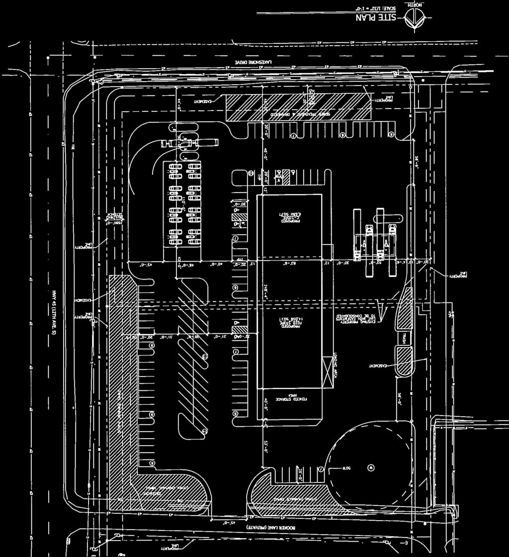
1 AAAA Planning and Zoning Staff Report Lake Shore Land Holdings, LLC CU-PH Hearing Date: April 21, 2016 Development Services Department Applicant: BRS Architects/Cindy Huebert Staff: Kyle McCormick, Tax ID: R , R Current Zone: C1 Neighborhood Commercial Lot Size/Project Area: 5.53 acres Current Uses: N/A Applicable Zoning Land Use Regulations: Conditional Use Permits Definitions Land Use Regulations Notification: May 20, 2016 Property Owners May 16, 2016 Nampa JEPA May 17, 2016 Agencies May 30, 2016 Legal May 20, Posting Exhibits: 1. FCO s 2. Aerial Photo 3. Applicant s letter of intent 4. Proposed Site Plan 5. Land Use Worksheet 6. Neighborhood Meeting Sign Up Sheet 7. Agency Comment Nampa Highway District #1 8. Agency Comment Idaho Department of Transportation Request Lake Shore Land Holdings, LLC represented by BRS architects is requesting a conditional use permit for a vehicle fueling station with a convenient store and attached feed store on parcels R & R The proposed development is located northwest of the intersection of Lake Shore Dr. and Hwy 45 on lots 2 & 3 of BC Six Subdivision, Canyon County, Idaho. Background This property was rezoned from A (Agricultural) to C-1 in 2002 and was approved for a subdivision plat (BC Six-SD ) in The property is assigned the Commercial Designation on the Comprehensive Plan Future Land Use Map (See Exhibit #1). The applicant has proposed to consolidate parcels R & R utilizing an existing approach on the northeast corner of the property and develop a new shared access on the southwest portion of the site. Analysis To approve a conditional use permit, Canyon County Code requires the Commission to make the following findings: (1) Is the proposed use permitted in the zone by conditional use permit; (2) What is the nature of the request; (3) Is the proposed use consistent with the comprehensive plan; (4) Will the proposed use be injurious to other property in the immediate vicinity and/or negatively change the essential character of the area; (5) Will adequate water, sewer, irrigation, drainage and stormwater drainage facilities, and utility systems be provided to accommodate the use; (6) Does legal access to the subject property for the development exist or will it exist at the time of final plat; Lake Shore Land Holdings, LLC CU-PH Page 1
2 (7) Will there be undue interference with existing or future traffic patterns; and (8) Will essential services be provided to accommodate the use including, but not limited to, school facilities, police and fire protection, emergency medical services, irrigation facilities, and will the services be negatively impacted by such use or require additional public funding in order to meet the needs created by the requested use? If a conditional use is approved, Canyon County Code allows the Commission to attach conditions, including, but not limited to the following: (1) Minimize adverse impact, such as damage, hazard, and nuisance, to persons or the subject property or property in the vicinity; (2) Control the sequence and timing of development; (3) Control the duration of development; (4) Designate the exact location and nature of development; (5) Require the provision for on site or off site public facilities or services; (6) Require more restrictive standards than those generally required in this chapter; or (7) Mitigate the negative impacts of the proposed development upon service delivery by any political subdivision, including school districts, providing services within the county (1) USE PERMITTED BY ZONE, DEFINITIONS, LAND USE REGULATIONS (MATRIX) A vehicle service and/or fueling station is defined by Canyon County Code as Premises used for the sale and delivery of petroleum products and parts such as fuel, lubrication oils, tires, and incidental vehicular accessories and related services, including minor motor vehicle repairs and/or rental of vehicles. The proposed use meets this definition (See Exhibit #3). Canyon County Code Land Use Regulations (Matrix) lists the allowed, conditionally permitted, and prohibited uses within the County. A vehicle fueling station with convenience store is listed as conditionally permitted in the C1 Neighborhood Commercial zone (2) NATURE OF THE REQUEST The nature of the applicant s request is to establish a vehicle fueling station with convenience store and attached feed store. (See Exhibit #3) (3) CONSISTENCY WITH COMPREHENSIVE PLAN Staff concludes the proposed uses are in conformance with the Comprehensive Plan. The subject property is located in the Commercial Designation of the Canyon County Comprehensive Plan Future Land Use Map. The Land Use Classifications Section of the Plan describes the Neighborhood Commercial Designation as intended to provide for commercial uses that can provide for a variety of commercial uses that provides goods and services to businesses, travelers and residents of the county, The proposed Lake Shore Land Holdings, LLC CU-PH Page 2
3 vehicle fueling station with convenience store and attached feed store as proposed will provide a good service to businesses, travelers and the residents of Canyon County. In addition, staff has determined the following Comprehensive Plan Goals and Policies are relevant to all uses in this case: Property Rights Policy No. 1- No person shall be deprived of private property without due process of law. The proposed application does not deprive property owners of private property. Property Rights Policy No. 8- Promote orderly development that benefits the public good and protects the individual with a minimum of conflict. A conditional use permit enables the Commission to place conditions that benefits the public good and protects the applicant and surrounding property owners. Property Rights Policy No. 11- Property owners shall not use their property in a manner that negatively impacts upon the surrounding neighbors or neighborhoods. The conditional use permit process enables the Commission to mitigate potential negative impact of uses on surrounding properties. Land Use Component Goal No. 2- To provide for the orderly growth and accompanying development of the resources within the county that is compatible with the surrounding area. Requiring a conditional use permit for this use enables the county to control for orderly growth and determine the compatibility of a use with surrounding properties. Land Use Component Goal No. 3- Use appropriate techniques to mitigate incompatible land uses. The conditional use permit process enables the Commission to determine if a land use is compatible with surrounding uses. Land Use Component Goal No. 5- Achieve a land use balance, which recognizes that existing agricultural uses and non-agricultural development may occur in the same area. The uses will not interfere with existing agricultural and residential uses and contributes to a land use balance in the area (4) IMPACT OF PROPOSED USE ON OTHER PROPERTY AND CHARACTER OF AREA; Staff has concluded the use should not be injurious to other property or negatively affect the character of the area, provided conditions are placed upon its use. The property is surrounded by a mix of commercial and agricultural properties and fits within the fabric of the comprehensive plan land use designation. The proposed vehicle fueling stations are to be located on the southern portion of the property and the c- store/feeding store is located in the center of the property overlaying current property lines. The parcels in question are directly adjacent to other neighborhood commercial (C1) properties and are buffered with several larger Service Commercial (C2) zoned properties. There lies a large amount of development in the rural residential zone, approximately a half mile north of the properties in question. A vehicle fueling station and convenient store, if operated without conditions, would directly affect the surrounding commercial and residential properties and contribute negatively to the character of the area if allowed to operate unconditioned. Staff recommends conditions of approval requiring that a traffic impact study be completed with review from Idaho Department of Transportation. Additional conditions of approval requiring a minor re-plat of the BC Six Subdivision would fix the property lines and easements that the proposed development s footprint is directly impacting. Staff also recommends that a condition of approval be that current parking requirements for retail stores be met ( ). In addition, the project Lake Shore Land Holdings, LLC CU-PH Page 3
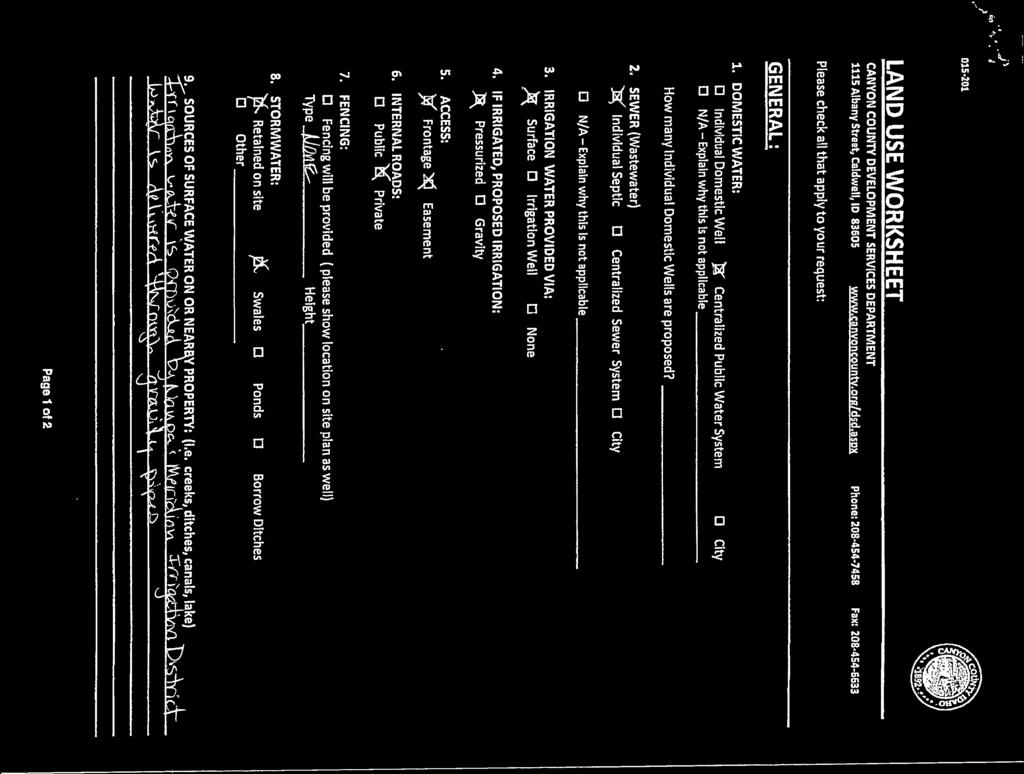
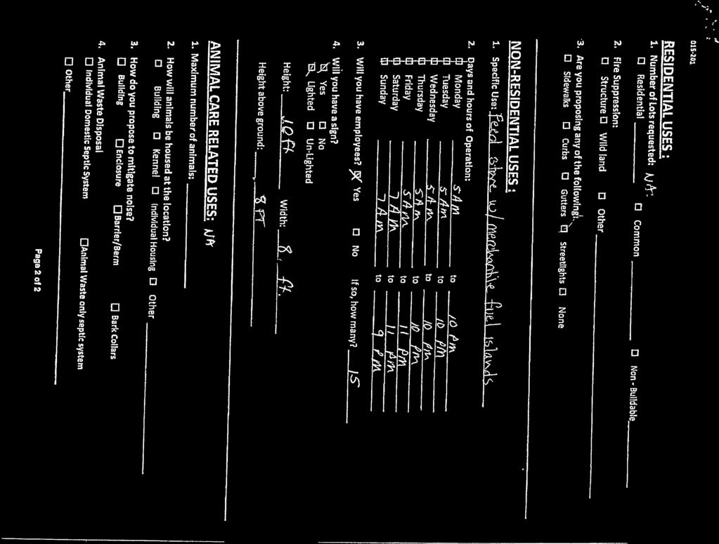
4 must commence within three (3) years of approval of the conditional use permit and be completed within (5) years of the same date. The applicant has proposed operating hours of 5:00 AM 10:00 PM, Monday through Thursday, 5:00 AM to 11:00 PM on Friday, 7:00 AM to 11:00 PM on Saturday and 7:00 AM to 9:00 PM on Sunday. (See Exhibit 5). The applicant has also proposed up to fifteen (15) employees. The applicant proposed the use of sign at a later date to be located along Highway 45, but in the case that a sign is proposed it must meet the sign requirements for commercial zone. Staff recommends a condition of approval limiting signs to the dimensions laid out in with a maximum of (64) square feet and not exceeding 10 feet in height or approval through administrative decision (5) AVAILABILITY OF WATER, SEWER, IRRIGATION, DRAINAGE AND STORMWATER DRAINAGE FACILITIES, AND UTILITY SYSTEMS The proposed structure for the convenient store and feed store will be on a public well system with the well to be located in northwest corner. Irrigation water is available from Nampa & Meridian Irrigation District. Electricity is available from Idaho Power. Drainage and storm water are retained on site (6) ACCESS TO PROPERTY Currently, legal access exists to the property from Booker Lane., a private road. The applicant is proposing that another access point be secured through a shared access in the Southwest corner of the parcel. Per comment received by Nampa Highway District (See Exhibit #7), the developer will need to submit plans to the Nampa Highway District #1 for a formal review. Staff recommends a condition of approval requiring the applicant to submit plans to Nampa Highway District #1 for formal review. Per comment received from the Idaho Department of Transportation (ITD) (See Exhibit #8), the applicant must apply for and receive an approved Right of Way use permit. Staff recommends a condition of approval requiring the applicant to receive an approved Right of Way use permit from ITD (7) INTERFERENCE WITH EXISTING OR FUTURE TRAFFIC PATTERNS Per comment received by ITD, this development could potentially generate more than 100 new trips during the peak hour or the new volume of trips will equal or exceed one thousand (1000) vehicles per day. ITD requested that as a part of IDAPA rules, a traffic impact study be completed. Staff recommends a condition of approval requiring the applicant to complete a traffic impact study per requirements set forth by IDAPA (See Exhibit #8) (8) AVAILABILITY OF SERVICES County services are available to the parcel, including police and emergency medical services. Staff finds no evidence in the record showing the proposal would interfere with the delivery of those services PRIVATE ROAD AND DRIVEWAY REQUIREMENTS The property and proposal meets Canyon County Code (Private Road and Driveway Requirements). The property exceeds the minimum 60 feet of road frontage required for access by Canyon County Code (1)(A). Lake Shore Land Holdings, LLC CU-PH Page 4
5 07-13 OFF STREET PARKING AND LOADING REQUIREMENTS Parking requirements are triggered when the intensity of a use, structure, or premises is increased through the addition of dwelling units, gross floor area, seating capacity or other unit of measurement requiring parking or loading facilities. If triggered, Canyon County Code lists the parking requirements of uses. The Commission can place more restrictive parking standards based on the uses. Comments Public Comment: Staff did not receive public comment regarding the application. Agency Comments: Staff notified affected agencies and the following agencies provided comment: Nampa Highway District #1 (Exhibit #7) and Idaho Department of Transportation (Exhibit #8). Options The Commission has the following options in this case: 1) The Planning and Zoning Commission may approve the conditional use permit as conditioned and/or amended; 2) The Planning and Zoning Commission may deny the conditional use permit in its entirety and direct staff to make findings of fact to support this decision; or 3) The Planning and Zoning Commission may continue the discussion and request additional information on specific items. Recommendation Staff recommends the Planning and Zoning Commission open a public hearing and discuss the proposed Conditional Use Permit. Staff is recommending approval of the request of conditional use permit application CU-PH , as shown in the findings of fact, conclusions of law, and order in Exhibit #1. Lake Shore Land Holdings, LLC CU-PH Page 5
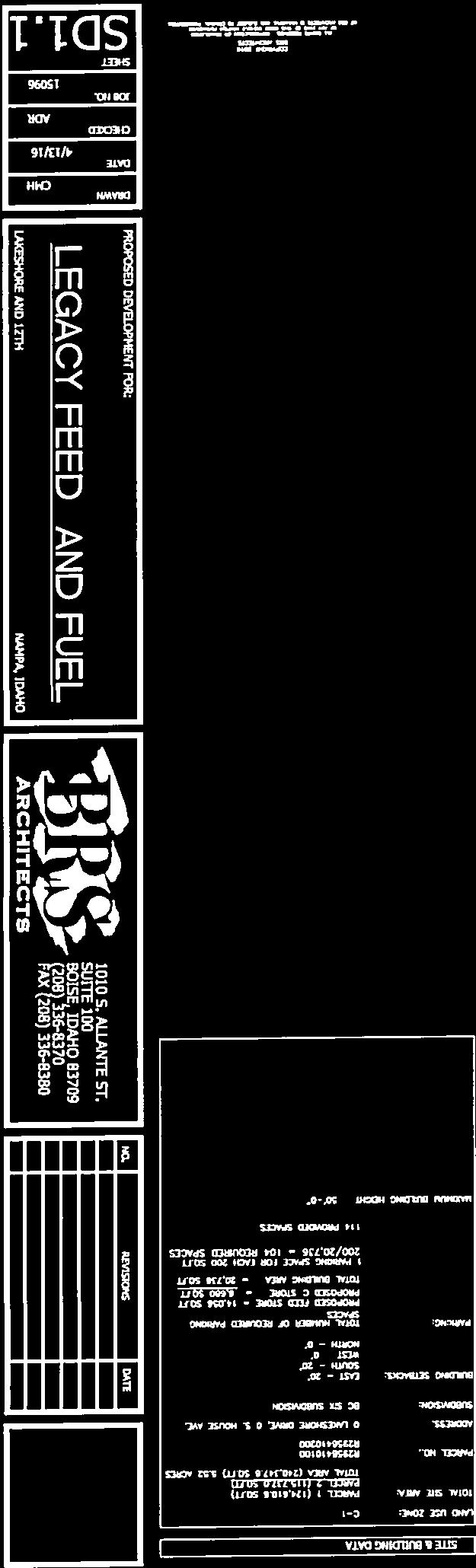
6 Canyon County Planning and Zoning Commission Lake Shore Land Holding, LLC CU-PH Development Services Department June 16, 2016 Findings of Fact, Conclusions of Law, and Order Lake Shore Land Holdings, LLC Findings of Fact 1. The property owner of both parcels is Lake Shore Land Holdings, LLC. 2. The subject property is located at 0 Lake Shore Dr. and 0 S. House Ave., Nampa, ID and are also known as tax parcels R & R The project area is approximately 5.52 acres. 3. The subject property is located in the C1 Neighborhood Commercial Zone. 4. The subject property is located in the Commercial Designation of the 2020 Canyon County Comprehensive Plan. 5. The proposed use is a vehicle fueling station with convenience store and attached feeding store. The use is listed as a conditional use in the C1 Neighborhood Commercial Zone per Canyon County Code (Land Use Regulations (Matrix)). 6. The subject property has access to State Highway 44 and Lake Shore Dr., a public road. 7. The subject property is located within Nampa Highway District #1, Upper Deer Flat Fire District, Nampa School District #131, and Boise Project Board of Control Irrigation District. 8. The application was noticed in accordance with Canyon County Code Property owners were noticed on May 20, Agencies were noticed on May 17, Legal noticing was completed on May 30, Property posting was completed on May 20, The record consists of exhibits 1 8 and all other documents located herein. Conclusions of Law For this request the Planning and Zoning Commission finds and concludes the following regarding the Standards of Review for Conditional Use Permit ( ): 1. Is the proposed use permitted in the zone by conditional use permit? A vehicle fueling station with convenience store is permitted in the (C1) Neighborhood Commercial zone by conditional use permit ( ). 2. What is the nature of the request? The nature of the applicant s request is to operate a vehicle fueling station with convenience store (See Exhibit #2). Lake Shore Land Holdings, LLC Exhibit 1 CU-PH Page 6
7 3. Is the proposed use consistent with the Comprehensive Plan? The proposed use is consistent with, but not limited to, the following Comprehensive Plan goals and policies: The subject property is located in the Commercial Designation of the Canyon County Comprehensive Plan Future Land Use Map. The Land Use Classifications Section of the Plan describes the Neighborhood Commercial Designation as intended to provide for commercial uses that can provide for a variety of commercial uses that provides goods and services to businesses, travelers and residents of the county, The proposed vehicle fueling station with convenience store and attached feed store as proposed will provide a good service to businesses, travelers and the residents of Canyon County. Property Rights Policy No. 1- No person shall be deprived of private property without due process of law. The proposed application does not deprive property owners of private property. Property Rights Policy No. 8- Promote orderly development that benefits the public good and protects the individual with a minimum of conflict. A conditional use permit enables the Commission to place conditions that benefits the public good and protects the applicant and surrounding property owners. Property Rights Policy No. 11- Property owners shall not use their property in a manner that negatively impacts upon the surrounding neighbors or neighborhoods. The conditional use permit process enables the Commission to mitigate potential negative impact of uses on surrounding properties. Land Use Component Goal No. 2- To provide for the orderly growth and accompanying development of the resources within the county that is compatible with the surrounding area. Requiring a conditional use permit for this use enables the county to control for orderly growth and determine the compatibility of a use with surrounding properties. Land Use Component Goal No. 3- Use appropriate techniques to mitigate incompatible land uses. The conditional use permit process enables the Commission to determine if a land use is compatible with surrounding uses. Land Use Component Goal No. 5- Achieve a land use balance, which recognizes that existing agricultural uses and non-agricultural development may occur in the same area. The uses will not interfere with existing residential uses and contributes to a land use balance in the area. 4. Will the proposed use be injurious to other property in the immediate vicinity and/or negatively change the essential character of the area? The uses should not be injurious to property in the immediate vicinity or negatively change the essential character of the area if conditions are applied that require access to be reviewed by local and State authorities. Lake Shore Land Holdings, LLC Exhibit 1 CU-PH Page 7
8 5. Will adequate water, sewer, irrigation, drainage and storm water drainage facilities, and utility systems be provided to accommodate the use? The proposed structure for the convenient store and feed store will be on a public well system with the well to be located in northwest corner. Irrigation water is available from Nampa & Meridian Irrigation District. Electricity is available from Idaho Power. Drainage and storm water are retained on site. 6. Does legal access to the subject property for the development exist or will it exist at the time of final plat? Legal access exists to the property from Booker Lane., a private road. The applicant is proposing that another access point be secured through a shared access in the southwest corner of the parcel. Per comment received by Nampa Highway District (See Exhibit #3), the developer will need to submit plans to the Nampa Highway District #1 for a formal review. 7. Will there be undue interference with existing or future traffic patterns? Per comment received by ITD, this development could potentially generate more than 100 new trips During the peak hour or the new volume of trips will equal or exceed one thousand (1000) vehicles per day. ITD requested that as a part of IDAPA rules, a traffic impact study be completed. 8. Will essential services be provided to accommodate the use including, but not limited to, school facilities, police and fire protection, emergency medical services, irrigation facilities, and will the services be negatively impacted by such use or require additional public funding in order to meet the needs created by the requested use? County services are available to the parcel, including police and emergency medical services. Evidence was not found on the record showing the proposal would interfere with the delivery of those services. Order Based upon the Findings of Fact, Conclusions of Law contained herein, the Planning and Zoning Commission APPROVES the request by Lake Shore Land Holdings, LLC for Case #CU-PH , for a vehicle fueling station with convenient store and attached feed store with the following conditions of approval: 1. The uses shall comply with all federal, state, and local laws, ordinances, rules, and policies. 2. The applicant shall be required to apply for and have approved a minor re-plat of the BC Six Subdivision to consolidate Block 1, Lots 2 and 3 and modify the private road name, property lines and easements that the proposed developments will impact. The minor replat shall be approved prior to applying for a building permit. 3. Current parking requirements for retail stores shall be met ( ). 4. All signs shall meet the dimensions laid out in with a maximum of (64) square feet and not exceeding 10 feet in height unless approval is obtained through administrative decision and shall comply with any applicable requirements of Canyon County Code, Chapter 6, Building Regulations 5. The applicant must submit plans to Nampa Highway District #1 for formal review prior to applying for a building permit. Lake Shore Land Holdings, LLC Exhibit 1 CU-PH Page 8
9 6. The applicant shall apply for and receive an approved Right of Way use permit from Idaho Department of Transportation for any work within the right-of-way of SH45 prior to applying for a building permit. 7. The applicant shall complete a traffic impact study (TIS) per requirements set forth by IDAPA and submit it to ITD prior to applying for a building permit. Any required improvements to SH45 approaches must be approved and inspected by ITD prior to issuance of a certificate of occupancy. 8. The project must commence within three (3) years of approval of the conditional use permit and be completed within (5) years of the same date. For the purposes of this permit, commencement is defined as receiving zoning compliance after submitting a building permit application. APPROVED this day of, PLANNING AND ZONING COMMISSION CANYON COUNTY, IDAHO Gary Duspiva, Chairman State of Idaho ) SS County of Canyon County ) On this day of, in the year 2016, before me, a notary public, personally appeared Gary Duspiva, personally known to me to be the person whose name is subscribed to the within instrument, and acknowledged to me that he(she) executed the same. Notary: My Commission Expires: Lake Shore Land Holdings, LLC Exhibit 1 CU-PH Page 9

10 IMAGES COURTESY OF PICTOMETRY AND WERE FLOWN IN THE FALL OF Lake Shore Land Holdings, LLC Small Air Photo HWY 45 BOOK ER LN LAKE SHORE DR Miles
11


12
13
14
15

16

17
18 May 24, 2016 John Van Dyke Canyon County Development Services Department 111 N. 11 th Ave., Ste. 140 Caldwell, ID VIA RE: CU-PH LEGACY FEED AND FUEL The Idaho Transportation Department (ITD) has reviewed the referenced conditional use application for Legacy Feed and Fuel on the northwest corner of Lake Shore Drive and SH-45. ITD has the following comments and requirements: 1. ITD has no objection to a vehicle fuel station with convenience store and attached feed store being constructed at this location. 2. Applicant must apply for and receive an approved Right-of-Way use permit prior to doing any work or activity within the State highway Right-of-Way. Please have the applicant contact Tyson McCoy at for more information about an application. 3. The application indicates widening of the existing approach for Booker Lane. Any change to the existing access, including widening and use, warrants updating to current IDAPA rules for spacing. Current IDAPA rules for access spacing on a Rural District Route upstream from a public road intersection is 760 feet and between accesses other than public roads is 500 feet for full access. The Booker Lane access does not meet the spacing upstream from a public road intersection. The applicant will need to show what they are willing to construct that will maintain the safety and mobility that IDAPA rules provide. A traffic impact study will be required. 4. IDAPA rules also state a traffic impact study is required when a new or expanded development seeks direct access to a State highway, and at full build out will generate one hundred (100) or more new trips during the peak hour or the new volume of trips will equal or exceed one thousand (1000) vehicles per day. This development will exceed these volumes. A traffic impact study is required for this development. 5. No trees are allowed within ITD Right-of-Way. Only planting of forage, plants, grasses, flowers, and shrubs with a mature height not to exceed 3 feet will be allowed. 6. No rocks over 4 inches maximum size will be allowed in the ITD Right-of-Way. 7. Section of the Idaho Code restricts the placement of any hedge, shrubbery, fence, wall, or other sight obstructions of any nature where they constitute a traffic hazard at the intersection of roads with other roads, private alleys, bike or pedestrian paths when they are

19 within the vision triangle of vehicle operators. The boundaries of the vision triangle are defined as follows: a. By extending perpendicular lines along the face of curb from their point of intersection 40 feet in either direction; and b. By a height between 3 feet and 10 feet above the existing centerline highway elevation. 8. Irrigation systems shall be no closer than 5 feet from the pavement edge and shall be adjusted so as not to cause water to cover any portion of the highway pavement. 9. Provisions shall be established for the responsibility of future maintenance of any landscaping within ITD Right-of-Way. 10. Idaho Code does not allow advertising within the right-of-way of any State highway system. 11. IDAPA rules govern outdoor advertising along the State highway system. The applicant can contact Dion Burch at for more information. If you have any questions, you may contact Ken Couch at or me at Sincerely, James K. Morrison Property Manager jim.morrison@itd.idaho.gov
Planning and Zoning Staff Report Pestcom Pest Management LLC CU-PH
 AAAA Planning and Zoning Staff Report Pestcom Pest Management LLC CU-PH2016-49 Hearing Date: October 6, 2016 Development Services Department Applicant: Charles F. Cooley Sr. Pestcom Pest Management LLC
Planning and Zoning Staff Report JT Ventures, LLC Staging Area, CU-PH
 Planning and Zoning Staff Report JT Ventures, LLC Staging Area, CU-PH2016-60 Hearing Date: December 15, 2016 Development Services Department Applicant: JT Ventures, LLC Jason Stewart and Tony Brown Staff:
Ricker - PH / Planning and Zoning Commission Staff Report
 / Planning and Zoning Commission Staff Report Ricker - PH2018-20 Hearing Date: April 19, 2018 Development Services Department Applicant: Don Ricker Staff: Dan Lister, Planner II dlister@canyonco.org Tax
Bethel Romanian Church - Rezone, RZ
 / Planning and Zoning Staff Report Bethel Romanian Church - Rezone, RZ2018-0023 Hearing Date: November 15, 2018 Development Services Department Owners: Bethel Romanian Church, Corp. Applicant: Viorel Botos
Mike & Sherry Dudley Rezone, RZ
 / Planning and Zoning Staff Report Mike & Sherry Dudley Rezone, RZ2019-0005 Hearing Date: April 18, 2019 Development Services Department Applicant: Mike & Sherry Dudley Staff: Deb Root, 454-7340 droot@canyonco.org
Tracie & Dennis Jones Rezone, RZ
 / Planning and Zoning Staff Report Tracie & Dennis Jones Rezone, RZ2018-0014 Applicant: Tracie & Dennis Jones Staff: Deb Root, 454-7340 droot@canyonco.org Tax ID: R37886012 Current Zone: A (Agricultural)
/ Planning and Zoning Commission Staff Report Jay Walker- All Terra Consulting - RZ
 / Planning and Zoning Commission Staff Report Jay Walker- All Terra Consulting - Hearing Date: January 17, 2019 Development Services Department Applicant: Jay Walker All Terra Consulting Staff: Jennifer
Planning and Zoning Staff Report Vallivue School District - PH
 Hearing Date: April 19, 2018 Planning and Zoning Staff Report - PH2018-16 Development Services Department Applicant: Nate Bondelid Owner: Staff: Dan Lister, Planner II (208) 455-5959 dlister@canyonco.org
Planning and Zoning Staff Report Meholchick Juniper Ranch, CU
 Applicant: Stan and Jeanie Meholchick Juniper Ranch Staff: Deb Root droot@canyonco.org Tax ID, Acres: R34083 (10.09 acres) Current Zone: A (Agriculture) Current Use: Rural Residential home site Impact
Planning and Zoning Staff Report Maverick Towers Van Wassenhove, PH
 Planning and Zoning Staff Report Maverick Towers Van Wassenhove, PH2018-17 Hearing Date: April 19, 2018 Development Services Department Applicant: Maverick Towers - Nadine Bostwick Owner: Paul Van Wassenhove
Planning and Zoning Staff Report for Serenity Hill Ranch - PH
 Hearing Date: March 1, 2018 Planning and Zoning Staff Report for Serenity Hill Ranch - Development Services Department Applicant: Serenity Hill Ranch Staff: Jennifer Almeida, 455-5957 jalmeida@canyonco.org
Planning and Zoning Commission Staff Report Shannan & Latrica Mays -Conditional Use Permit - CU
 Planning and Zoning Commission Staff Report Shannan & Latrica Mays -Conditional Use Permit - Hearing Date: January 17, 2019 Development Services Department Applicant: Shannan & Latrica Mays Staff: Jennifer
AAAA. Planning and Zoning Staff Report Zoning Text Amendment, ZOA-PH Request
 AAAA Hearing Date: September 3, 2015 Planning and Zoning Staff Report Zoning Text Amendment, ZOA-PH2015-23 Development Services Department Applicant: Request Staff: Christian Samples, 455-5958 csamples@canyonco.org
Radford Ridges Subdivision, SD-PH
 / Planning and Zoning Staff Report Radford Ridges Subdivision, SD-PH2017-22 Hearing Date: August 3, 2017 Development Services Department Applicant: James Radford Representative: TJ Wellard Skinner Land
ARTICLE XI CONDITIONAL USE PERMITS
 ARTICLE XI CONDITIONAL USE PERMITS 11.1 Purpose. The City of Hailey recognizes that certain uses possess unique and special characteristics with respect to their location, design, size, method of operation,
Planning Director Boise City Planning and Development Services Department. CUP (Adoption of Findings & Revised Conditions of Approval)
") MEMORANDUM TO: FROM: Mayor and Boise City Council Hal Simmons Planning Director Boise City Planning and Development Services Department DATE: May 19, 2006 RE: CUP05-00172 (Adoption of Findings & Revised
MEMORANDUM TO: FROM: Mayor and Boise City Council Hal Simmons Planning Director Boise City Planning and Development Services Department DATE: May 19, 2006 RE: CUP05-00172 (Adoption of Findings & Revised
Planning & Zoning Commission Staff Report for Honey Bee Acres Subdivision, SD-PH
 Planning & Zoning Commission Staff Report for Honey Bee Acres Subdivision, SD-PH2018-0009 Hearing Date: August 16, 2018 Development Services Department Applicant: Kelley & Carrie Dick Staff: Kyle McCormick,
UPPER MOUNT BETHEL TOWNSHIP NORTHAMPTON COUNTY, PENNSYLVANIA
 UPPER MOUNT BETHEL TOWNSHIP NORTHAMPTON COUNTY, PENNSYLVANIA JOINDER DEED / LOT CONSOLIDATION TOWNSHIP REVIEW PROCESS When accepting proposed Joinder Deeds / Lot Consolidations, review the Joinder Deed
ADMINISTRATIVE HEARING STAFF REPORT
 ADMINISTRATIVE HEARING STAFF REPORT Providence Place Apartments Utility Box No. 2 Conditional Use Petition PLNPCM2011-00426 309 East 100 South September 22, 2011 Planning and Zoning Division Department
II. What Type of Development Requires Site Plan Review? There are five situations where a site plan review is required:
 I. What is a Site Plan Review? Site Plan Review is a process where the construction of new buildings, new additions, and certain types of canopies and/or tax-exempt institutions are reviewed by the City
Date: March 16, Jake Centers ERD, LLC P.O. Box 1610 Eagle, ID Elevation Ridge Subdivision (SUB & PUD ) Street Address
 Street Address") Rebecca W. Arnold, President Sara M. Baker, Vice President John S. Franden, Commissioner Carol A. McKee, Commissioner David L. Case, Commissioner Date: March 16, 2012 To: Jake Centers ERD, LLC P.O. Box
Rebecca W. Arnold, President Sara M. Baker, Vice President John S. Franden, Commissioner Carol A. McKee, Commissioner David L. Case, Commissioner Date: March 16, 2012 To: Jake Centers ERD, LLC P.O. Box
Finnerty, Shawn & Lori Water Front Setback
 BONNER COUNTY PLANNING DEPARTMENT PLANNING AND ZONING COMMISSION STAFF REPORT FOR NOVEMBER 2, 2017 Project Name: Finnerty, Shawn & Lori Water Front Setback File Number, Type: FILE #V492-17, Variance Request
PERMITTED USES: Within the MX-1 Mixed Use Neighborhood District the following uses are permitted:
 6.25 MX-1 - MIXED USE NEIGHBORHOOD 6.25.1 INTENT: The purpose of the MX-1 Mixed Use Neighborhood District is to accommodate the development of a wide-range of residential and compatible non-residential
May 21, ACHD Board of Commissioners Stacey Yarrington, Planner II DRH /DRH
 Development Services Department May 21, 2013 TO: FROM: SUBJECT: ACHD Board of Commissioners Stacey Yarrington, Planner II DRH13-00106/DRH13-00108 Executive Summary: This is a design review application
LAGRANGE TOWNSHIP BOARD OF ZONING APPEALS REQUEST FOR HOME OCCUPATION/CONDITIONAL PERMIT NEW
 LAGRANGE TOWNSHIP BOARD OF ZONING APPEALS REQUEST FOR HOME OCCUPATION/CONDITIONAL PERMIT NEW I AM REQUESTING A CONDITIONAL ZONING PERMIT FOR A HOME OCCUPATION. PRESENT ZONING DISTRICT: DATE: DESCRIPTION
May 23, 2017 Staff Report to the Board of Zoning Ad justment. C AS E # VAR I t e m #1. Location Map. Subject
 May 23, 2017 Staff Report to the Board of Zoning Ad justment C AS E # VAR 2 0 1 7-00031 I t e m #1 U N I T E D R E N TA L S O R L A N D O Location Map S U M M A R Y Owner Herbert R. Matthews, Jr. Applicant
Finnerty, Shawn & Lori Water Front Setback
 BONNER COUNTY PLANNING DEPARTMENT BOARD OF COUNTY COMMISSIONERS STAFF REPORT FOR JANUARY 10, 2018 Project Name: Finnerty, Shawn & Lori Water Front Setback File Number, Type: FILE #V492-17, Variance Request
EXTRA TERRITORIAL ZONING AUTHORITY CASE ANALYSIS
 DOÑA ANA COUNTY CASE # V09-007 COMMUNITY PLANNING AND ECONOMIC DEVELOPMENT DEPARTMENT Building Planning GIS 845 North Motel Boulevard Las Cruces, New Mexico 88007 (575) 647-7350 Fax: (575) 525-6131 Toll
Glades County Staff Report and Recommendation Unified Staff Report for Small Scale Plan Amendment and Rezoning
 Glades County Staff Report and Recommendation Unified Staff Report for Small Scale Plan Amendment and Rezoning CASE NUMBERS: COMP17-02 and RZ17-02 DATE of STAFF REPORT: May 1, 2017 CASE TYPE: Application
Conditional Use Permit case no. CU 14-06: Bristol Village Partners, LLC
 PLANNING AND ZONING COMMISSION STAFF REPORT August 7, 2014 Conditional Use Permit case no. CU 14-06: Bristol Village Partners, LLC CASE DESCRIPTION: LOCATION: LEGAL DESCRIPTION: EXISTING LAND USE: ZONING:
Draft Model Access Management Overlay Ordinance
 Draft Model Access Management Overlay Ordinance This model was developed using the City of Hutchinson and the Trunk Highway 7 corridor. The basic provisions of this model may be adopted by any jurisdiction
Planning Department Oconee County, Georgia
 Planning Department Oconee County, Georgia STAFF REPORT REZONE CASE #: 6985 DATE: October 31, 2016 STAFF REPORT BY: Andrew C. Stern, Planner APPLICANT NAME: Williams & Associates, Land Planners PC PROPERTY
Operating Standards Attachment to Development Application
 Planning & Development Services 2255 W Berry Ave. Littleton, CO 80120 Phone: 303-795-3748 Mon-Fri: 8am-5pm www.littletongov.org Operating Standards Attachment to Development Application 1 PLANNED DEVELOPMENT
O-I (Office-Institutional) and AG-1(Agricultural)
 and AG-1(Agricultural)") PROPERTY INFORMATION ADDRESS 3503 and 3505 Bethany Bend DISTRICT, LAND LOTS 2/1 973 and 974 OVERLAY DISTRICT State Route 9 PETITION NUMBERS EXISTING ZONING O-I (Office-Institutional) and AG-1(Agricultural)
PROPERTY INFORMATION ADDRESS 3503 and 3505 Bethany Bend DISTRICT, LAND LOTS 2/1 973 and 974 OVERLAY DISTRICT State Route 9 PETITION NUMBERS EXISTING ZONING O-I (Office-Institutional) and AG-1(Agricultural)
Right-of-Way & Development Services Planning Review Division Committed to Service This application is approved at the staff level on February 1, 2006.
 Right-of-Way & Development Services Planning Review Division Committed to Service This application is approved at the staff level on February 1, 2006. Tech Review for this item was held with the applicant
Committed to Service
 Committed to Service Sara M. Baker, President Rebecca W. Arnold, Vice President Jim D. Hansen, Commissioner Kent Goldthorpe, Commissioner Paul Woods, Commissioner January 16, 2018 Development Services
APPLICANT NAME SUBDIVISION NAME DEVELOPMENT NAME LOCATION. CITY COUNCIL DISTRICT Council District 4 PRESENT ZONING PROPOSED ZONING
 SUBDIVISION, PLANNED UNIT DEVELOPMENT, PLANNING APPROVAL, ZONING AMENDMENT, & SIDEWALK WAIVER REQUEST STAFF REPORT Date: February 17, 2010 APPLICANT NAME SUBDIVISION NAME DEVELOPMENT NAME LOCATION David
PLANNING COMMISSION REPORT Regular Agenda -Public Hearing Item
 PDP-13-00518 Item No. 3B- 1 PLANNING COMMISSION REPORT Regular Agenda -Public Hearing Item PC Staff Report 2/24/14 ITEM NO. 3B PRELIMINARY DEVELOPMENT PLAN FOR HERE @ KANSAS; 1101 INDIANA ST (SLD) PDP-13-00518:
AN ORDINANCE TO AMEND SECTION OF THE RAPID CITY MUNICIPAL CODE TO ALLOW FOR ADMINISTRATIVE DISSOLUTION OF PLANNED DEVELOPMENTS
 Ordinance No. 6231 AN ORDINANCE TO AMEND SECTION 17.50.050 OF THE RAPID CITY MUNICIPAL CODE TO ALLOW FOR ADMINISTRATIVE DISSOLUTION OF PLANNED DEVELOPMENTS WHEREAS, the City of Rapid City has adopted a
Committed to Service
 Committed to Service Paul Woods, President Rebecca W. Arnold, Vice President Sara M. Baker, Commissioner Jim D. Hansen, Commissioner Kent Goldthorpe, Commissioner August 25, 2017 Development Services TO:
Medical Marijuana Special Exception Use Information
 Medical Marijuana Special Exception Use Information The Special Exception Use information below is a modified version of the Unified Development Code. It clarifies the current section 5:104 Special Exceptions
Larimer County Planning Dept. Procedural Guide for 1041 PERMITS
 - Larimer County Planning Dept. Procedural Guide for 1041 PERMITS PLEASE NOTE: A PRE-APPLICATION CONFERENCE IS REQUIRED PRIOR TO SUBMITTING THIS APPLICATION. PURPOSE: State Statutes allow local governments
WRITTEN DECISION OF THE HAYDEN CITY COUNCIL REGARDING MAPLE GROVE PRELIMINARY SUBDIVISION APPLICATION (SUB-0013) HAYDEN SIGNATURE, LLC
 HAYDEN SIGNATURE, LLC") WRITTEN DECISION OF THE HAYDEN CITY COUNCIL REGARDING MAPLE GROVE PRELIMINARY SUBDIVISION APPLICATION (SUB-0013) HAYDEN SIGNATURE, LLC Application of Hayden Signature, LLC, an Idaho limited liability company,
WRITTEN DECISION OF THE HAYDEN CITY COUNCIL REGARDING MAPLE GROVE PRELIMINARY SUBDIVISION APPLICATION (SUB-0013) HAYDEN SIGNATURE, LLC Application of Hayden Signature, LLC, an Idaho limited liability company,
Time Extension Staff Report
 Time Extension Staff Report Subdivision Name Lunara Subdivision File Number SUB07-00019 Approval Time Extension for Lead Agency Boise City Certification Signature of Boise City Engineer Annexation Date
Date: August 29, Dave Scaggs (sent via ) Summit Development Inc th Ave. Rd. #384 Nampa, ID 83686
 Summit Development Inc th Ave. Rd. #384 Nampa, ID 83686") Sara M. Baker, President John S. Franden, Vice President Rebecca W. Arnold, Commissioner Mitchell A. Jaurena, Commissioner Jim Hansen, Commissioner Date: August 29, 2013 To: Dave Scaggs (sent via email)
Sara M. Baker, President John S. Franden, Vice President Rebecca W. Arnold, Commissioner Mitchell A. Jaurena, Commissioner Jim Hansen, Commissioner Date: August 29, 2013 To: Dave Scaggs (sent via email)
CHAPTER 3 PRELIMINARY PLAT
 10-3-1 10-3-3 SECTION: CHAPTER 3 PRELIMINARY PLAT 10-3-1: Consultation 10-3-2: Filing 10-3-3: Requirements 10-3-4: Approval 10-3-5: Time Limitation 10-3-6: Grading Limitation 10-3-1: CONSULTATION: Each
Section Preliminary Plat Checklist and Application Forms
 Section 201 - Preliminary Plat Checklist and Application Forms PRELIMINARY SUBDIVISION PLAT REVIEW PROCESS CHART PRELIMINARY SUBDIVISION PLAT APPLICATION PRELIMINARY PLAT REVIEW CHECKLIST CITY OF NAMPA
APPLICATION SUBMITTAL REQUIREMENTS FOR Tentative Parcel or Subdivision Maps
 CITY OF EL CERRITO Community Development Department Planning and Building Division 10890 San Pablo Avenue, El Cerrito, CA 94530 (510) 215-4330 FA (510) 233-5401 planning@ci.el-cerrito.ca.us APPLICATION
PLANNED DEVELOPMENT DISTRICT STANDARDS. Cadence Site
 PLANNED DEVELOPMENT DISTRICT STANDARDS Cadence Site A Planned Development District 1. Statement of General Facts, Conditions and Objectives Property Size: Approximately 57.51 Acres York County Tax Map
CHAPTER 3 PERMITS, PLANS AND ANNEXATION
 CHAPTER 3 PERMITS, PLANS AND ANNEXATION SECTION: 10-3-1: General Regulations 10-3-2: Building Permit 10-3-3: Plans 10-3-4: Certificate of Compliance and Occupancy 10-3-5: Conditional Use Permits 10-3-6:
Committed to Service. License Agreement Application Form
 Committed to Service License Agreement Application Form PLEASE NOTE: Effective February 16, 2010 - License Agreements within the downtown Boise area for public structures, objects and uses on ACHD sidewalks
Minor Replat Celebration Pointe Peterson Road TECHNICAL REVIEW PROJECT: #
 March 15, 2018 Tony Huerta 3501 Industrial 29 th Street Fort Pierce, FL 34946 SUBJECT: Comments: Minor Replat Celebration Pointe - 5501 Peterson Road TECHNICAL REVIEW PROJECT: # 18-05000001 1. The plan
ARTICLE 143. PD 143.
 ARTICLE 143. PD 143. SEC. 51P-143.101. LEGISLATIVE HISTORY. PD 143 was established by Ordinance No. 17685, passed by the Dallas City Council on February 2, 1983. Ordinance No. 17685 amended Ordinance No.
FINAL PLAT. Community Development Department 8101 Ralston Road Arvada, Colorado 80002
 FINAL PLAT Community Development Department 8101 Ralston Road Arvada, Colorado 80002 September 2015 FINAL SUBDIVISION PLAT Final Subdivision Plat Review Applications for a Final Plat shall be submitted
Committed to Service
 Committed to Service Kent Goldthorpe, President Paul Woods, Vice President Rebecca W. Arnold, Commissioner Sara M. Baker, Commissioner Jim D. Hansen, Commissioner July 18, 2016 Development Services TO:
Section 7.01 Area Regulations
 SECTION 7: AREA, YARD AND FENCE REGULATIONS Section 7.01 Area Regulations Except as hereinafter provided, no building or structure or part thereof shall be erected, altered or converted for any use permitted
Moore Township Planning Commission 2491 Community Drive, Bath, Pennsylvania Telephone: FAX: Rev:12/23/2013
 2491 Community Drive, Bath, Pennsylvania Telephone: 610-759-9449 FAX: 610-759-9448 Rev:12/23/2013 APPLICATION FORM FOR A SITE PLAN PER MOORE TOWNSHIP ZONING ORDINANCE SECTION 200-58.1 NORTHAMPTON COUNTY,
STAFF REPORT FOR MAJOR SUBDIVISION
 STAFF REPORT FOR MAJOR SUBDIVISION FINAL PLAT CASE NO. FA-12-003 HEARING DATE: November 6, 2013 CASE NAME: Solterra Subdivision Filing No. 13 PROCEDURE: Planning Commission ADDRESS OF MAJOR SUBDIVISION
Article 9 Signs and Billboards
 Article 9 Signs and Billboards Section 9.01 Intent and Purpose The intent of this article is to regulate the type, number, physical dimensions, erection and placement of signs in Arbela Township. The purpose
EXTRA-TERRITORIAL ZONING AUTHORITY
 EXTRA-TERRITORIAL ZONING AUTHORITY DOÑA ANA COUNTY COMMUNITY DEVELOPMENT DEPARTMENT Doña Ana County Government Complex 845 North Motel Boulevard Las Cruces, New Mexico 88007 Office: (575) 647-7237 MEETING
CHAPTER 154: SIGNS. Section
 CHAPTER 154: SIGNS Section 154.01 Permit required 154.02 Where prohibited 154.03 Street decorations 154.04 Approval by state 154.05 Purpose 154.06 Definitions 154.07 General sign and street graphics regulations
ARTICLE 24 SITE PLAN REVIEW
 ARTICLE 24 SITE PLAN REVIEW 24.1 PURPOSE: The intent of these Ordinance provisions is to provide for consultation and cooperation between the land developer and the Township Planning Commission in order
ARTICLE 467. PD 467.
 ARTICLE 467. PD 467. SEC. 51P-467.101. LEGISLATIVE HISTORY. PD 467 was established by Ordinance No. 23046, passed by the Dallas City Council on February 26, 1997. Ordinance No. 23046 amended Ordinance
SITE DEVELOPMENT PLAN APPLICATION PAHRUMP REGIONAL PLANNING DISTRICT
 SITE DEVELOPMENT PLAN APPLICATION PAHRUMP REGIONAL PLANNING DISTRICT AREA BETWEEN DOUBLE LINES FOR STAFF USE ONLY FOR SUBMITTAL REQUIREMENTS, PLEASE SEE REVERSE DATE FILED: APPLICATION NUMBER: SD COMMUNITY
ZONING AMENDMENT, PLANNED UNIT DEVELOPMENT & SUBDIVISION STAFF REPORT Date: August 8, 2013
 ZONING AMENDMENT, PLANNED UNIT DEVELOPMENT & SUBDIVISION STAFF REPORT Date: August 8, 2013 NAME SUBDIVISION NAME PV-Magnolia, LLC Twelve Trees Subdivision LOCATION 2860, 2862 and 2866 Pleasant Valley Road
SPRING BROOK TOWNSHIP 966 STATE ROUTE 307 SPRING BROOK TOWNSHIP, PA PHONE (570) FAX (570)
 FAX (570)") PERMIT # - D SPRING BROOK TOWNSHIP 966 STATE ROUTE 307 SPRING BROOK TOWNSHIP, PA 18444 PHONE (570) 842-7028 FAX (570) 842-0633 Date: PART I APPLICATION DRIVEWAY INSTALLATION APPLICATION AND PERMIT Name:
PERMIT # - D SPRING BROOK TOWNSHIP 966 STATE ROUTE 307 SPRING BROOK TOWNSHIP, PA 18444 PHONE (570) 842-7028 FAX (570) 842-0633 Date: PART I APPLICATION DRIVEWAY INSTALLATION APPLICATION AND PERMIT Name:
Executive Summary: This is a preliminary plat to construct 8 residential lots and 2 commons lots with a private road on 3.87-acres in Meridian, Idaho.
 Development Services Department DATE: July 7, 2015 TO: FROM: SUBJECT: ACHD Board of Commissioners Stacey Yarrington, Planner III Kentucky Villas/ MPP15-0012/ PP15-009 Executive Summary: This is a preliminary
Conditional Use Permit / Standard Subdivision Application
 Conditional Use Permit / Standard Subdivision Application Name of Proposed Subdivision: Total Area (Acres) Is Proposed Subdivision to be built in phases? Number of Lots If yes, how many phases? Applicant/Owner
Letter of Intent May 2017 (Revised November 2017)
") THE BEACH AT WOODMOOR LETTER OF INTENT MAY 2017 (REVISED NOVEMBER 2017) OWNER/APPLICANT: CONSULTANT: Lake Woodmoor Holdings LLC N.E.S. Inc. 1755 Telstar Drive, Suite 211 619 North Cascade Avenue Colorado
THE BEACH AT WOODMOOR LETTER OF INTENT MAY 2017 (REVISED NOVEMBER 2017) OWNER/APPLICANT: CONSULTANT: Lake Woodmoor Holdings LLC N.E.S. Inc. 1755 Telstar Drive, Suite 211 619 North Cascade Avenue Colorado
ARTICLE 14 PLANNED UNIT DEVELOPMENT (PUD) DISTRICT
 DISTRICT") ARTICLE 14 PLANNED UNIT DEVELOPMENT (PUD) DISTRICT Section 14.01 Intent. It is the intent of this Article to allow the use of the planned unit development (PUD) process, as authorized by the Michigan Zoning
ARTICLE 14 PLANNED UNIT DEVELOPMENT (PUD) DISTRICT Section 14.01 Intent. It is the intent of this Article to allow the use of the planned unit development (PUD) process, as authorized by the Michigan Zoning
SOS / Waiver of Subdivision Standards / John Cashin
 SOS15-00012 / Waiver of Subdivision Standards / John Cashin Summary John Cashin requests a Waiver of Subdivision Standards in the Boise Development Code that requires construction of new sidewalk for approval
If you have any questions, please feel free to contact me at (208)
") Sara M. Baker, President John S. Franden, Vice President Rebecca W. Arnold, Commissioner Mitchell A. Jaurena, Commissioner Jim Hansen, Commissioner Date: March 21, 2013 To: Subject: Hornet Construction
Sara M. Baker, President John S. Franden, Vice President Rebecca W. Arnold, Commissioner Mitchell A. Jaurena, Commissioner Jim Hansen, Commissioner Date: March 21, 2013 To: Subject: Hornet Construction
November 9, 2016 Ponderay Planning and Zoning Commission File AX Annexation Request Thomas L. Clark. Preliminary Survey of Subject Parcel
 Ponderay - City Planning Staff Report November 9, 2016 Ponderay Planning and Zoning Commission File AX16-013 Annexation Request Thomas L. Clark Subject Parcels Preliminary Survey of Subject Parcel Project
STAFF REPORT FOR MAJOR SUBDIVISION
 STAFF REPORT FOR MAJOR SUBDIVISION FINAL PLAT CASE NO. FA-13-001 HEARING DATE: November 6, 2013 CASE NAME: Solterra Subdivision Filing No. 14 PROCEDURE: Planning Commission ADDRESS OF MAJOR SUBDIVISION
SUBDIVISION, PLANNED UNIT DEVELOPMENT, PLANNING APPROVAL, ZONING AMENDMENT, & SIDEWALK WAIVER REQUEST STAFF REPORT Date: February 17, 2010
 SUBDIVISION, PLANNED UNIT DEVELOPMENT, PLANNING APPROVAL, ZONING AMENDMENT, & SIDEWALK WAIVER REQUEST STAFF REPORT Date: February 17, 2010 APPLICANT NAME SUBDIVISION NAME DEVELOPMENT NAME LOCATION David
Special Land Use. SLU Application & Review Standards
 review and approval is needed for certain uses of property that have the potential to impact adjacent properties and the neighborhood. The application and review procedure is intended to ensure that the
The following regulations shall apply in the R-E District:
 "R-E" RESIDENTIAL ESTATE DISTRICT (8/06) The following regulations shall apply in the R-E District: 1. Uses Permitted: The following uses are permitted. A Zoning Certificate may be required as provided
CONDITIONAL USE PERMIT APPLICATION FOR AN EXCAVATION/BORROW PIT INSTRUCTIONS
 City of Chesapeake Department of Planning Post Office Box 15225 Chesapeake, Virginia 23328-5225 (757) 382-6176 FAX (757) 382-6406 CONDITIONAL USE PERMIT APPLICATION FOR AN EXCAVATION/BORROW PIT INSTRUCTIONS
City of Melissa, Texas Plat Dedication Language
 City of Melissa, Texas Plat Dedication Language [INCLUDE THE FOLLOWING DEDICATION LANGUAGE FOR INDIVIDUALS (MODIFY APPROPRIATELY TO REFLECT EXACTLY AS SHOWN ON PROPERTY DEED)]: NOW THEREFORE, KNOW ALL
PALM BEACH COUNTY PLANNING, ZONING AND BUILDING DEPARTMENT ZONING DIVISION
 PALM BEACH COUNTY PLANNING, ZONING AND BUILDING DEPARTMENT ZONING DIVISION Application No.: Z-2014-01627 Application Name: Dazco Center Control No.: 2003-00040 Applicant: 4730 Hypoluxo LLC Owners: 4730
4-1 TITLE 6 MOBILE HOME AND RECREATIONAL VEHICLE PARKS 4-3
 4-1 TITLE 6 MOBILE HOME AND RECREATIONAL VEHICLE PARKS 4-3 Chapter 4 RECREATIONAL VEHICLE PARKS Sec. 4-1: Sec. 4-2: Sec. 4-3: Sec. 4-4: Sec. 4-5: Sec. 4-6: Sec. 4-7: Sec. 4-8: Sec. 4-9: Sec. 4-10: Sec.
Code of Ordinances, Town of Chincoteague, VA Abstracted March CHAPTER 2.
 Code of Ordinances, Town of Chincoteague, VA Abstracted March 2016 http://www.chincoteague-va.gov/pdf/town-code2010.pdf CHAPTER 2. POWERS OF TOWN Sec. 1. Generally. 15. To acquire, establish, enter, open,
CHAPTER SHORT SUBDIVISIONS
 CITY OF MOSES LAKE MUNICIPAL CODE CHAPTER 17.09 SHORT SUBDIVISIONS Sections: 17.09.010 Purpose 17.09.020 Scope 17.09.030 Preliminary Short Subdivision Conditions and Requirements 17.09.040 Referral to
WILTON MANORS, Island City 2020 WILTON DRIVE, WILTON MANORS, FLORIDA 33305
 WILTON MANORS, Island City 2020 WILTON DRIVE, WILTON MANORS, FLORIDA 33305 COMMUNITY DEVELOPMENT SERVICES (954) 390-2180 FAX: (954) 567-6069 PLAT APPLICATION PACKAGE This package includes: General Submittal
PLANNED UNIT DEVELOPMENT (PUD)
") SECTION 38.01. ARTICLE 38 PLANNED UNIT DEVELOPMENT (PUD) Purpose The purpose of this Article is to implement the provisions of the Michigan Zoning Enabling Act, Public Act 110 of 2006, as amended, authorizing
SECTION 38.01. ARTICLE 38 PLANNED UNIT DEVELOPMENT (PUD) Purpose The purpose of this Article is to implement the provisions of the Michigan Zoning Enabling Act, Public Act 110 of 2006, as amended, authorizing
Title 17 MOBILE HOMES AND RECREATIONAL VEHICLES
 17.04 General Provisions Title 17 MOBILE HOMES AND RECREATIONAL VEHICLES 17.04.010 General provisions 17.04.020 Application 17.04.030 Interpretation 17.04.040 Mobile homes and recreational vehicles--location
PLANNING COMMISSION STAFF REPORT. Merrimac PLNSUB Planned Development 38 West Merrimac November 9, Request. Staff Recommendation
 PLANNING COMMISSION STAFF REPORT Merrimac PLNSUB2011-00374 Planned Development 38 West Merrimac November 9, 2011 Planning and Zoning Division Department of Community and Economic Development Applicant:
APPLICATION PROCEDURES FOR A PLAT AMENDMENT OR REVISION
 APPLICATION PROCEDURES FOR A PLAT AMENDMENT OR REVISION DEFINITION: Any revision or amendment to an approved recorded or unrecorded final plat. A revision (not recorded) does not require a public hearing
PUD Ordinance - Cascade Lakes Plat #10 of 1995
 PUD Ordinance - Cascade Lakes Plat #10 of 1995 CASCADE CHARTER TOWNSHIP Ordinance #10 of 1995 AN ORDINANCE TO AMEND THE CASCADE CHARTER TOWNSHIP ZONING ORDINANCE AND ZONING MAP TO ESTABLISH THE CASCADE
BARROW COUNTY, GEORGIA
 BARROW COUNTY, GEORGIA Application For Rezoning, Special Use, and Change in Conditions BARROW COUNTY DEPARTMENT OF PLANNING AND DEVELOPMENT 30 North Broad Street Winder, Georgia 30680 770-307-3034 APPLICATION
B. The Plan is in conformity with the Comprehensive Plan.
 ARTICLE 17 PLANNING UNIT DEVELOPMENT 17.01 INTENT The purpose of this Section is to permit the creation of new Planned Unit Developments, permitted as Conditional Uses where maximum variations of design
PRELIMINARY SUBDIVISION PLAN APPLICATION INSTRUCTIONS
 City of Chesapeake Department of Planning Post Office Box 15225 Chesapeake, Virginia 23328-5225 (757) 382-6176 FAX (757) 382-6406 PRELIMINARY SUBDIVISION PLAN APPLICATION INSTRUCTIONS PURPOSE A preliminary
Special Use Permit - Planned Unit Development Checklist. Property Address:
 Special Use Permit - Planned Unit Development Checklist Special Use Permit Number. Parcel Code/s #28-11- - - Property Address: Applicant: ARTICLE VIII Ordinance Reference - Section 8.1.2 Permit Procedures:
5. That the Owner shall agree that all development Blocks shown within the Draft Plan will be connected to full municipal services.
 Conditions Relating to Draft Plan of Subdivision Approval East Fonthill 26T 01014 (Draft Plan dated December 1, 2013, and revised August 28, 2014), the Town of Pelham 1. This approval applies to the Draft
Time Extension Staff Report
 Time Extension Staff Report Subdivision Name Therrin Subdivision File Number SUB06-00020 Approval Time Extension for Lead Agency Boise City Certification Signature of Boise City Engineer Annexation Date
REQUIREMENTS FOR FINAL SITE PLAN Final Site Plan must be submitted within 12 months of a Conceptual Site Plan approval
 REQUIREMENTS FOR FINAL SITE PLAN Final Site Plan must be submitted within 12 months of a Conceptual Site Plan approval The applicant must submit a complete application for final site plan approval to the
French, Bruce. The applicant is requesting a zone change from Suburban to Rural Service Center.
 BONNER COUNTY PLANNING DEPARTMENT PLANNING AND ZONING COMMISSION STAFF REPORT FOR FEBRUARY 2, 2017 Project Name: French, Bruce File Number,Type: ZC358-16, Zone Change Request: The applicant is requesting
ARTICLE 900 PLAT AND PLAN REQUIREMENTS
 ARTICLE 900 PLAT AND PLAN REQUIREMENTS SEC. 900.1 ITEMS TO BE SHOWN ON PLAT OR PLAN General (1) Property lines of all property owners adjacent to the exterior boundaries of the project shall be located
SECTION 7000 LAND DEVELOPMENT REQUIREMENTS
 SECTION 7000 LAND DEVELOPMENT REQUIREMENTS 7000 LAND DEVELOPMENT REQUIREMENTS... 1 7001 LEGISLATIVE AUTHORITY... 1 7001.1 LAND DEVELOPMENT... 1 7001.1.1 Title 40, Idaho Code... 1 7001.1.2 Idaho Code 40-1415
ZONING AMENDMENT, PLANNED UNIT DEVELOPMENT & SUBDIVISION STAFF REPORT Date: March 5, 2009
 ZONING AMENDMENT, PLANNED UNIT DEVELOPMENT & SUBDIVISION STAFF REPORT Date: March 5, 2009 NAME SUBDIVISION NAME LOCATION Kentress Morrisette Booker T. Washington Highlands Subdivision, First Addition,