INSPIRED Property. Ownership, Planning, Protection and the People
|
|
|
- Marshall Davidson
- 5 years ago
- Views:
Transcription

1 INSPIRED Property Ownership, Planning, Protection and the People Robin Waters, Royal Institution of Chartered Surveyors, UK Robin McLaren, Know Edge, UK Piroska Zalaba, Ministry of Rural Development, Hungary


2 Importance of property to the economy Without an integrated and formalised real property system, a modern economy is not viable.


3
4 Property lifecycle & access to information Land is not (often) created or destroyed & cannot be moved Can be owned by governments, organisations or individuals Use often has a life cycle different information needs Use is constrained 1. by natural factors geology, soil, climate, topography 2. by regulation land use planning, protected sites, etc 3. by price which will be influenced by 1 & 2 above Access to information about all of these is essential for a real estate market to flourish and help the economy


5 Land use planning on the Forth or the Danube


6 INSPIRE datasets for property
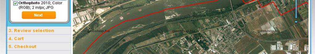
7 Property information services Fragmented by data producer (usually public sector) Cadastre/mapping agency; geological survey; environment agency; local planning authority; etc. Integration has been frustrated Diff. technical standards; licensing & charging issues; bureaucratic indifference or rigidity New portals and services are being developed Private sector: Landmark, F!ND, Groundsure; emapsite Public sector: data.gov.uk, Land Registry, RoS, Ordnance Survey, GeoHub NI, etc Hungarian Takarnet24, geoshop


8 Land Office Online in Hungary

9 Registers of Scotland


10 GIS formatted LDPs 24 th February 2011

 Building Heights")
11 F!ND Property Package Listed Buildings Heritage Planning Applications Flood constraints Conservation Areas Protected Views Postcodes Boundaries (Admin & Elect) Building Heights (London) Crossrail (areas affected) Built 24 th February 2011
12 How / where will INSPIRE help? Accessibility to information about property Interoperability of this information Provides platform for many potential services: For more efficient government & administration For private sector planning, development, construction, facilities management For citizens for own property and also for better informed democracy
13 Where will INSPIRE not help? INSPIRE itself may lead to information overload! Decisions need information filtering and prioritising Citizens need interpretation and bespoke services Common presentation of information e.g. local development plans? Managing crowd-sourced information But all of these can be improved with services built on or around INSPIRE datasets
14 Conclusions INSPIRE should help make datasets more accessible Improved information for property markets More efficient property life-cycle Easier international property transactions Property markets are fundamental to economy and make use of best available information if accessible and reasonably priced. Commercial services best placed to deliver services for the property industry based on authoritative datasets.
15 Web sites referenced:


16 Thank you
Hungarian practice of servicing cadastral information Piroska Zalaba senior counselor
 Hungarian practice of servicing cadastral information Piroska Zalaba senior counselor Ministry of Agriculture and Rural Development Department of Land Administration and Geoinformation Cadastre, Public
National Spatial Data Infrastructure development in Republic of Macedonia
 National Spatial Data Infrastructure development in Republic of Macedonia Sonja Dimova, state advisor for geomatics AGENCY FOR REAL ESTATE CADASTRE September 6-th, 2017, Strasbourg AREC competence for
DATR towards e-land Administration in Hungary
 DATR towards e-land Administration in Hungary Gyula IVÁN-Gábor SZABÓ-Zoltán WENINGER-Piroska Zalaba Institute of Geodesy, Cartography and Remote Sensing, Budapest, HUNGARY XXIV. FIG Congress Facing the
Test and Implementation of DATR System in Hungary
 Test and Implementation of DATR System in Hungary, Hungary Key words: unified land registry, cadastral map, Hungary SUMMARY During the last years there has been an important development in the Hungarian
Digitalisation of the Real Property Rights Towards Spatially enabled E-Government
 Digitalisation of the Real Property Rights Towards Spatially enabled E-Government Lise Schroeder, Bent Hulegaard Jensen, Esben Munk Soerensen & Line Hvingel Istanbul, Turkey 25 june 201 Overview Introduction
Country report, HUNGARY
 Country report, HUNGARY Gyula IVÁN Institute of Geodesy, Cartography & Remote Sensing (FÖMI) HUNGARY FIG Commission 7 Annual Meeting 2009 12-16 October, 2009, Kuala Lumpur, Malaysia Institute of Geodesy,
Land Administration Infrastructures for Sustainable Development
 The Global Challenges Land Administration Infrastructures for Sustainable Development Prof. Stig Enemark Department of Development and Planning Aalborg, University, Denmark INTERNATIONAL CONFERENCE ON
Historic Environment Scotland
 Historic Environment Scotland 1 of 14 Condition Monitoring System for properties in the care of Scottish Ministers and associated collections. September 2015 2 of 14 Purpose and Scope This document sets
e-land Administration in Hungary
 e-land Administration in Hungary Piroska Zalaba senior counsellor, project manager Ministry of Agriculture and Rural Development Department of Lands and Mapping FIG SEMINAR Innsbruck, 2-4 June 2004 Land
Challenges for the multi purpose cadastre
 Jens RIECKEN, Markus SEIFERT, Germany Key words: Multi purpose cadastre, 3d-cadastre, land use, SDI, solar cadastre SUMMARY Over the past 30 years, with the progress of information technologies the development
Creation Land Administration in Formal and Informal Environment. FIG Commission 7 Working Group 1
 Creation Land Administration in Formal and Informal Environment András OSSKÓ, Hungary Key words: land administration, informal land tenure, customary tenure, sustainable Development. SUMMARY FIG Commission
Hungary is a landlocked, Central European country in the Carpathian Basin
 Brief Overview on Hungarian Land Administration MSc. György Domokos Hungarian Geodetic Surveying Liaison Group CLGE GA Hannover 12 13 October 2012 Hungary is a landlocked, Central European country in the
A Digital Land and Property Information Service for Scotland. Report to the Deputy First Minister
 A Digital Land and Property Information Service for Scotland Report to the Deputy First Minister Background 1. In March 2015, the Deputy First Minister announced his commitment to Scotland having an easy-to-use
EVOLUTION TOWARDS THE DIGITAL LAND OFFICES
 EVOLUTION TOWARDS THE DIGITAL LAND OFFICES Szabolcs MIHÁLY, Piroska ZALABA Budapest, Hungary 1. INTRODUCTION 2. CURRENT STATUS OF THE UNIFORM LAND REGISTRATION 2.1. Management Features of the Hungarian
KEY REGISTERS AS BASE OF THE DUTCH SDI
 CO-151 KEY REGISTERS AS BASE OF THE DUTCH SDI BAKKER N.J. Kadaster, APELDOORN, NETHERLANDS This paper reports on the realisation of the Key Registers in the Netherlands as the foundation of the Dutch National
The Development of the Austrian Cadastre from Documentation to an Integrated Planning and Decision Support System
 The Development of the Austrian Cadastre from Documentation to an Integrated Planning and Decision Support System WPLA - Working Party on Land Administration 15-17 October 2014, Vienna, Austria Wernher
Unified Land Administration for a Better Spatial Infrastructure
 Unified Land Administration for a Better Spatial Infrastructure Gyula IVÁN Institute of Geodesy, Cartography & Remote Sensing FÖMI (HUNGARY) Open Symposium 30th Korean Cadastral Seminar & FIG Commission
The Multipurpose Hungarian Unified Land Registry System
 The Multipurpose Hungarian Unified Land Registry System András Osskó FIG Working Week Integrating Generation Stockholm, Sweden 14-19 June 2008 Republic of Hungary is located in Central Europe Neighbouring
Property Transactions in the Digital Age. The Property Cadastre in the Context of Spatial. Dr. Jens Riecken, NRW Ministry of the Interior
 Property Transactions in the Digital Age The Property Cadastre in the Context of Spatial Data Infrastructure (SDI) Dr. Jens Riecken, NRW Ministry of the Interior Property Transactions in the Digital Age
Spatial Data Warehouse Ltd. Cadastral Mapping INITIATIVE 1: CADASTRAL MAPPING. Version Spatial Data Warehouse Ltd. & AltaLIS Ltd.
 Spatial Data Warehouse Ltd. Initiative 1: Cadastral Mapping INITIATIVE 1: CADASTRAL MAPPING 29 P3 The SDW/AltaLIS Model Background The Government of Alberta started a mapping program, the Municipal Integrated
Use of data in Ukraine for sustainable economic growth. Oleksandr Maliuk State Service of Ukraine for Geodesy, Cartography and Cadastre
 Use of data in Ukraine for sustainable economic growth Oleksandr Maliuk State Service of Ukraine for Geodesy, Cartography and Cadastre Kehl, 2017 Content of the presentation Ukraine & StateGeoCadastre:
DATR Towards e-land Administration in Hungary
 DATR Towards e-land Administration in Hungary Gyula IVÁN, Gábor SZABÓ, Zoltán WENINGER, Piroska ZALABA, HUNGARY Key words: Land Registry, Cadastre, Land Administration, GIS SUMMARY DATR has been the most
The importance of changes in land surveyors education
 András OSSKÓ Key words: land administration, roles of land surveyors, extended education, lifelong learning SUMMARY It s a world wide experience, especially in developed countries that the interest in
Spatial Data Infrastructure in Sweden
 Spatial Data Infrastructure in Sweden Hans-Erik WIBERG, Sweden Key words: ABSTRACT Sweden was one of the first countries to address Data Infrastructure matters and have during several decades developed
Information contained
 Government Information (Public Access) Act 2009 (GIPA Act) LPI Information Guide 1. Introduction and contents of this guide The Land and Property Information s (LPI) Information Guide tells you in general
NSDI assessment for the Netherlands
 for the Netherlands Ruby Beltman, Geonovum May 24 2007 Presentation the Dutch public geo-information playing field Geonovum and the Dutch NSDI need for results The Dutch public geo-information playing
Proposals for Best Practice
 WPLA Fees & Charges in Cadastre and Registration Proposals for Best Practice Neil King United Kingdom WPLA Fees and Charges Study Best Practice This presentation offers an overview of a draft report that
Meeting the Changing National Geospatial Information Needs. Palitha Udayakantha Surveyor General - Sri Lanka
 Meeting the Changing National Geospatial Information Needs Palitha Udayakantha Surveyor General - Sri Lanka Sri Lanka Location Latitude 5 55 10-9 50 6 North Longitude 79 31 19-81 52 36 East Area 65610
Hungarian Cadastre and its relation to LADM
 Hungarian Cadastre and its relation to LADM Gyula IVÁN CLGE General Assembly 22 March 2013, Budapest, HUNGARY Content Historical background Evolution of Cadastral modeling in Hungary LADM issues Conclusion
Smart Infrastructure Benefits and Key Players from a Global Perspective
 Smart Infrastructure Benefits and Key Players from a Global Perspective Spatial@gov 2010 October 5-7 Canberra Jude Wallace and Abbas Rajabifard Centre for Spatial Data Infrastructures and Land Administration
TAKARNET intranet for the land administration
 Paper presented at the FIG Commission 3 Annual Meeting and Seminar Budapest, Hungary, 1999 TAKARNET intranet for the land administration Piroska Zalaba Ministry of Agriculture and Regional Development
Global Eradication of Infectious Diseases
 Global Security of Tenure Campaign the Time of Rights Dr Robin McLaren Land Professional Know Edge Limited Location Information Innovation COMMISSION 7 ANNUAL MEETING, COIMBRA, PORTUGAL OCTOBER 2016 1
Map Modernization Modernization Program
 FEMA Map Modernization Program Presented to Maryland Association of Floodplain and Stormwater Managers October 27, 2005 Map Modernization Program Autorun.exe 2 Map Modernization Program Outline Map Mod
Land and Geographic Information, an Important Part of the Infrastructure in Sweden
 Land and Geographical Information Land and Geographic Information, an Important Part of the Infrastructure in Sweden Land and Geographic Information, an Important Part of the Infrastructure In Sweden Bo
Coastal Zone Management Land Administration Capacity Building
 Closing Address Prof. Stig Enemark President 6th FIG Regional Conference Coastal Areas and Land Administration - Building the Capacity San José, Costa Rica, 12 15 November 2007 Three Main Themes Coastal
Support of Disaster Management by Land Administration and SDI
 Support of Disaster Management by Land Administration and SDI Key words: Spatial Data Infrastructure, Land Administration, GIS, Disaster Management SUMMARY Institute of Geodesy, Cartography and Remote
Surveying in Austria. Congress Maanmittauspäivät Seinäjoki, 20 th March 2014
 Surveying in Austria Congress Maanmittauspäivät Seinäjoki, 20 th March 2014 Topics Facts, figures Organisational issues of surveying Role of the BEV Products, services The Cadastre Surveying Education
The Role of the Swedish Land Information System
 The Role of the Swedish Land Information System In the Business Society Tommy Österberg Swedesurvey 1 SWEDEN 9 million inhabitants 450 000 sq. km 21 Counties 291 Municipalities 4.6 million properties in
INTRODUCTION OF CHARGES FOR STREET NAMING, HOUSE NUMBERING, AND CHANGING A HOUSE NAME
 INTRODUCTION OF CHARGES FOR STREET NAMING, HOUSE NUMBERING, AND CHANGING A HOUSE NAME Report by Service Director, Customer and Communities EXECUTIVE COMMITTEE 21 November 2017 1 PURPOSE AND SUMMARY 1.1
Introduction to Land Tenure Administration
 Introduction to Land Tenure Administration Karol Boudreaux Land Tenure & Resource Rights Practice Lead, The Cloudburst Group January 22, 2018 January 22, 2018 1 WHAT WE LL COVER Background and Definitions
THINKING OUTSIDE THE TRIANGLE TAKING ADVANTAGE OF MODERN LAND MARKETS. Ian Williamson
 THINKING OUTSIDE THE TRIANGLE TAKING ADVANTAGE OF MODERN LAND MARKETS Ian Williamson Professor of Surveying and Land Information Head, Department of Geomatics Director, Centre for Spatial Data Infrastructures
DELIVERING BUILD TO RENT: Are you ready? Part 2
 DELIVERING BUILD TO RENT: Are you ready? Part 2 Top ten Build to Rent questions answered The emergent Build to Rent sector is triggering investment and causing a stir amongst the industry. But with any
(UNECE) John Manthorpel
 John Manthorpel") Lanc Registration and Land Valuation in the United Kingdom and in the countries of the United Nations Economic Commission for Europe (UNECE) John Manthorpel Introduction This paper is in two parts and
Lanc Registration and Land Valuation in the United Kingdom and in the countries of the United Nations Economic Commission for Europe (UNECE) John Manthorpel Introduction This paper is in two parts and
Fit-For-Purpose what is it?
 FIG Commission 7 Annual Meeting 2016 Working Group 7.1 Fit-For-Purpose Land Administration Christiaan Lemmen October, 24th 2016 Coimbra, Portugal Fit-For-Purpose what is it? Fit-for-purpose: The systems
Object Oriented Unified Real Estate Registry for a Good Spatial Data Management
 Object Oriented Unified Real Estate Registry for a Good Spatial Data Management Gyula IVÁN Gábor SZABÓ Zoltán WENINGER Institute of Geodesy, Cartography and Remote Sensing (FÖMI), Hungary Workshop on e-governance,
Germany on the way to a 4D-Cadastre
 Germany on the way to a 4D-Cadastre Dr. Jens Riecken (DVW Vicepresident), Ulrich Gruber, Dr. Markus Seifert (DVW WG Geoinformation) TS 9.1 4D Cadastre, Land Domain Models & Concepts 1 Content About my
Community Empowerment and Renewal Bill A Consultation. Response from the Chartered Institute of Housing Scotland
 Consultation response Community Empowerment and Renewal Bill A Consultation Response from the Chartered Institute of Housing Scotland September 2012 www.cih.org/scotland Introduction The Chartered Institute
1st Regional INSPIRE Forum 4th Croatian NSDI and INSPIRE Day
 1st Regional INSPIRE Forum 4th Croatian NSDI and INSPIRE Day State of Play EULIS Rik Wouters Managing Director EULIS Programme What is EULIS EULIS is renewed: LINE For who is EULIS? Why EULIS? Projects
Croatian SDI: a Tool for Accelerated Development of the Geo-Conscious Society
 STATE GEODETIC ADMINISTRATION Croatian SDI: a Tool for Accelerated Development of the Geo-Conscious Society Prof.Dr.Sc. Željko Bačić, Mr.Sc. Ljerka Rašić FIG Working Week 2009 - Surveyors Key Role in Accelerated
Social and Economic Benefits of Good Land Administration (Second Edition)
") United Nations Economic Commission for Europe Working Party on Land Administration Social and Economic Benefits of Good Land Administration (Second Edition) Published by HM Land Registry, London, on behalf
United Nations Economic Commission for Europe Working Party on Land Administration Social and Economic Benefits of Good Land Administration (Second Edition) Published by HM Land Registry, London, on behalf
RIBA Tender Brief RIBA Core CPD 2018 programme
 Royal Institute of British Architects RIBA Tender Brief RIBA Core CPD 2018 programme 1.0 Context The RIBA CPD programme is designed to help delegates get the CPD they need. Methods of CPD learning are
CROSSRAIL INFORMATION PAPER C10 - LAND DISPOSAL POLICY
 CROSSRAIL INFORMATION PAPER C10 - LAND DISPOSAL POLICY This paper sets out the Crossrail land disposal policy as published in November 2005. It will be of particular relevance to owners of land subject
AREC responsibilities, data and registries and the way of their distribution
 Data as a basis of the digital society PCC, 13-15 March 2018, Sofia AREC responsibilities, data and registries and the way of their distribution Vlatko Dimovski Agency for Real Estate Cadastre (AREC) the
Building a national SDI. Approach and strategy in The Netherlands
 Agenda 1. NSDI vision and implementation strategy 2. NSDI playing field 3. Standards framework for the NSDI 4. National SDI components for IM Information model public safety SDI Portal for public safety
Obtaining and using Tenancy Deposit information
 Obtaining and using Tenancy Deposit information Explanatory booklet for Local Housing Authorities April 2017 Department for Communities and Local Government Crown copyright, 2017 Copyright in the typographical
The Contribution of Forest Owners Associations for the Forest Cadastre Implementation. João Gaspar Ana Navarro Ferreira PORTUGAL
 The Contribution of Forest Owners Associations for the Forest Cadastre Implementation João Gaspar Ana Navarro Ferreira PORTUGAL Motivation Lack of forestry cadastre; Unify all FOAs databases with common
THE XXV FIG INTERNATIONAL CONGRESS IN MALAYSIA Kuala Lumpur, Malaysia, June 2014 at Kuala Lumpur Convention Centre
 CALL FOR PAPERS TO THE XXV FIG INTERNATIONAL CONGRESS IN MALAYSIA Kuala Lumpur, Malaysia, 16 21 June 2014 at Kuala Lumpur Convention Centre Dear Friend and Colleague, It is our privilege and honour to
PROBLEMS IN REGISTRATION IN THE THIRD VERTICAL DIMENSION IN THE UNIFIED LAND REGISTRY IN HUNGARY, AND POSSIBLE SOLUTION
 3D Cadastres Technical and Legal Aspects II PROBLEMS IN REGISTRATION IN THE THIRD VERTICAL DIMENSION IN THE UNIFIED LAND REGISTRY IN HUNGARY, AND POSSIBLE SOLUTION ANDRÁS Osskó Budapest Land Office Hungary
Cadastre and Land Registration in Europe
 Annex A: Questionnaire 2007 for Information Resource Cadastre and Land Registration in Europe Introduction This questionnaire is based on the EuroGeographics vision document 'Cadastre and Land Registration
Building the Environmental Capacity of the Surveyor
 Philip WILBOURN, United Kingdom Key words: sustainability, development, environment, contaminated, land, surveyor, capacity. SUMMARY The floods of June 2007 created wide spread damage and there has been
IDENTIFIED AAAAAAAAAAAAAAA CLICK TO VIEW THE MAP
 RiskView Residential Contaminated Land PASSED We believe there is no significant risk of contaminated land at or close to the property. Please turn the page for further information. Flood PASSED The property
DIRECTORATE DEEDS REGISTRATION SUB-SECTOR PROGRAMME. Title security of tenure to real property. Description
 DIRECTORATE DEEDS REGISTRATION SUB-SECTOR PROGRAMME Title security of tenure to real property Description Throughout the world and from early times, countries have endeavoured to have a system of land
Croatian NSDI - An example of AGISEE country web-page. Vlado Cetl and Miljenko Lapaine
 Croatian NSDI - An example of AGISEE country web-page Vlado Cetl and Miljenko Lapaine Introduction 2/18 Guidelines AGISSE Country Pages should provide an overview of the situation of SDIs in the countries
East Lothian Local Development Plan Main Issues Report. Proposed Residential Allocation Land at Glenkinchie. On behalf of Aithrie Estates
 East Lothian Local Development Plan Main Issues Report Proposed Residential Allocation Land at Glenkinchie On behalf of Aithrie Estates February 2015 PPCA Limited Job no: 916.11 East Lothian Local Development
A Review and Perspective on Parcel Data Models for Urban Planning
 A Review and Perspective on Parcel Data Models for Urban Planning Yiqiang Ouyang Prof. Dr. Ilir Bejleri Department of Urban and Regional Planning University of Florida June 19-21, 2010 1 Content 1. Introduction
Integrated Land Information Services in Hungarian Land Administration
 , Hungary Key words: key words, theme, etc. SUMMARY The Unified Hungarian Land Registry, in which cadastral mapping and land registry belong to the same organization (Land Office Network), has been operating
The Digital Cadastral Database and the Role of the Private Licensed Surveyors in Denmark
 IRISH INSTITUTE OF SURVEYORS, DUBLIN INSTITUTE OF TECHNOLOGY, 23 NOVEMBER 2005 PUBLISHED IN IIS NEWS, WINTHER 2006. The Digital Cadastral Database and the Role of the Private Licensed Surveyors in Denmark
How Big is Global Insecurity of Tenure?
 Presented at the FIG Working Week 2016, May 2-6, 2016 in Christchurch, New Zealand Know Edge Limited Location Information Innovation How Big is Global Insecurity of Tenure? Dr Robin McLaren Know Edge Ltd,
FOR SCOTLAND. Response to the Land Reform Review Group
 FOR SCOTLAND Response to the Land Reform Review Group 1. The Historic Houses Association for Scotland (HHAS) represents around 250 individually owned historic castles, houses and gardens throughout Scotland.
IMOE Market Intelligence
 IMOE Market Intelligence Presentation July 2008 1 What is it? IMOE Market Intelligence is an information system with national coverage, it characterises in-depth the housing markets in each of the 308
Flood Hazard Area Land Use Management Guidelines Sea Level Rise Amendment. Effective January 1, 2018
 Flood Hazard Area Land Use Management Guidelines Sea Level Rise Amendment Effective January 1, 2018 What are the Flood Hazard Area Land Use Guidelines used for again? Flood Hazard Area Land Use Management
BC OnLine. Rural Property Tax Search User s Guide. Last Updated November 25, 2016
 BC OnLine Rural Property Tax Search User s Guide Last Updated November 25, 2016 Copyright Copyright 2016 Province of British Columbia. All rights reserved. This user s guide is for users of the BC OnLine
Improvement of Effectiveness Present Developments in Hungarian Land Administration
 Improvement of Effectiveness Present Developments in Hungarian Land Administration Gyula IVÁN and András OSSKÓ, Hungary Key words: Land Administration, Cadastre, Land Registry SUMMARY New Act on Surveying
Egyptian Nationwide Title Cadastre System
 Kholoud SAAD, Egypt Key words: Cadastre, Registration, Urban, Rural, National Cadastre, Automation, reengineering. SUMMARY With growing need for integrated information, Enterprise Solutions has become
Recent Developments in Use and Dissemination of Geospatial Data in Germany - Example Lower Saxony
 Recent Developments in Use and Dissemination of Geospatial Data in Germany - Example Lower Saxony Conference Permanent Committee on Cadastre Lithuanian Presidency Vilnius, 22 October 2013 Peter Creuzer
Expansion of Land Information Services in Hungarian Land Administration
 Expansion of Land Information Services in Hungarian Land Administration Gyula IVÁN, Gábor SZABÓ and Zoltán WENINGER, Hungary Key words: Land registry, Cadastral system, GIS, LIS, WEB based services SUMMARY
New Danish e-cadastre and its role in the Danish e-government
 New Danish e-cadastre and its role in the Danish e-government PCC Budapest 2011 Pia Dahl Højgaard, pdh@kms.dk Cadastre and Legal Authority, National Survey and Mapping, Denmark The danish context Neighbours
Cadastral Parcels in INSPIRE. Lisbon, 27 February 2013
 Cadastral Parcels in INSPIRE Lisbon, 27 February 2013 Dominique.laurent@ign.fr Plan INSPIRE context The modeling approach for theme Cadastral Parcels Implementation of INSPIRE theme Cadastral Parcels Context
A Complete, Free Solution for Cadastral Map Management
 A Complete, Free Solution for Cadastral Map Management Gyula IVÁN Institute of Geodesy, Cartography & Remote Sensing (FÖMI) HUNGARY FIG Commission 7, Annual Meeting 11-15 September 2008., Verona, ITALY
Fit-For-Purpose Land Administration: Developing Country Specific Strategies for Implementation Enemark, Stig; McLaren, Robin
 Aalborg Universitet Fit-For-Purpose Land Administration: Developing Country Specific Strategies for Implementation Enemark, Stig; McLaren, Robin Published in: Responsible Land Governance: Towards an Evidence
e-land Administration: An International Seminar in Innsbruck
 e-land Administration: An International Seminar in Innsbruck Christiaan LEMMEN and Paul van der MOLEN, the Netherlands and Gerda SCHENNACH, Austria Keywords: land administration, e-conveyancing, e-lodgement,
Land Administration In Public Private Partnerships
 Land Administration In Public Private Partnerships Workshop Customers - Co-operation - Services Vienna, 12-13 September 2002 Peter Creuzer Content Land Administration - Tasks History Spatial Data Infrastructure
Status and Perspectives of the Geodesy, Cartography and Cadastre Authority Availability of Geographic Information in Slovakia.
 Status and Perspectives of the Geodesy, Cartography and Cadastre Authority Availability of Geographic Information in Slovakia Hedviga Májovská Geodesy, Cartography and Cadastre Authority of the Slovak
GIS & GPS Applications in Valuation/Appraisal Assessments
 GIS & GPS Applications in Valuation/Appraisal Assessments Simon ADCOCK, Australia Key words: GIS, GPS, mass assessments, 3-dimensional, modelling. SUMMARY The development of GIS and GPS systems has substantially
The Society of Chartered Surveyors Ireland - enhancing, advancing and enforcing professional standards in construction, land and property.
 The Society of - enhancing, advancing and enforcing professional standards in construction, land and property. 1 Overview Independent Expert Qualified The Society of is the leading professional body for
The principal tasks or competencies of the General Directorate of Cadastre are:
 4th Quality Conference 1/7 1) Title of the case. Spanish e Cadastre ( Virtual Office of Cadastre, or OVC). An open space for sustainable quality in cadastral data, working with land management administrations.
Rural Land Markets in Central and Western Europe
 András OSSKÓ, Hungary and Jan K. B. SONNENBERG, The Netherlands Key words: Central European Countries (CECs), Western European Countries (WECs), Rural Land Market, Ownership Structure. ABSTRACT After the
MAKING THE MOST EFFECTIVE AND SUSTAINABLE USE OF LAND
 165 SOC146 To deliver places that are more sustainable, development will make the most effective and sustainable use of land, focusing on: Housing density Reusing previously developed land Bringing empty
THE NEED FOR APPROACHES AND TECHNOLOGY OF TOMORROW
 THE NEED FOR APPROACHES AND TECHNOLOGY OF TOMORROW KEES DE ZEEUW, CHRISTIAAN LEMMEN and BERNY KERSTEN Cadastre, Land Registry and Mapping Agency - Kadaster, The Netherlands Kees.dezeeuw@kadaster.nl Paper
Transfer of Participation (Expiry/Termination of Registered Forestry Right or Lease) Emissions Trading Scheme (Forestry) Post 1989
 Emissions Trading Scheme (Forestry) Post 1989") Transfer of Participation ( of or Lease) Emissions Trading Scheme (Forestry) Post 1989 ETSP89TE.6 Use this form if you are a party: from whom post-1989 forest land that is registered in the Emissions Trading
Transfer of Participation ( of or Lease) Emissions Trading Scheme (Forestry) Post 1989 ETSP89TE.6 Use this form if you are a party: from whom post-1989 forest land that is registered in the Emissions Trading
The doughnut of social and planetary boundaries for development Chemical pollution Greenhouse gases Atmospheric particle loading Transformation within
 Are We Embracing the Global Transformative Forces? FUTURE 12 Fredrik Zetterquist, Chair UN-ECE WPLA The doughnut of social and planetary boundaries for development Chemical pollution Greenhouse gases Atmospheric
LAND DEVELOPMENT CHECKLIST GREEN TREE BOROUGH Green Tree Planning Commission 10 West Manilla Avenue Pittsburgh, PA
 TO BE COMPLETED BY BOROUGH: LAND DEVELOPMENT CHECKLIST GREEN TREE BOROUGH Green Tree Planning Commission 10 West Manilla Avenue Pittsburgh, PA 15220 412-921-1110 SP - - DATE STAMP RECEIVED NOTE TO ALL
GI support for land consolidation
 Problems GI support for land consolidation Bela MARKUS University of West Hungary College of Geoinformatics Technology??? Legislation Organization Financial Awareness Ill-structured process 2 Past Present
LIS a motivation for SDI initiative
 Eric Mwaikambo Ardhi University Dar es Salaam Tanzania Overview Status of LIS in Tanzania Relationship between SDI and LIS Spatial Standards LIS a motivation for SDI initiative Conclusion & Recommendations
Rights Responsibilities Restrictions (RRRs)
") 37 th Australasian Conference of Registrars of Title 26-29 October 2010, Perth WA Rights Responsibilities Restrictions (RRRs) Any factor which affects the use of public or private land below, or on, or
37 th Australasian Conference of Registrars of Title 26-29 October 2010, Perth WA Rights Responsibilities Restrictions (RRRs) Any factor which affects the use of public or private land below, or on, or
Making housing finance markets work for the poor A perspective on the role of big data. Illana Melzer
 Making housing finance markets work for the poor A perspective on the role of big data Illana Melzer Illana@71point4.com 2 Big data is generated everywhere. How much of it is justifiably in the line of
Role of Republic Geodetic Authority in the Serbian geo-sector
 Role of Republic Geodetic Authority in the Serbian geo-sector Republic Geodetic Authority, Serbia www.rgz.gov.rs EuroGeographics General Assembly 2014 Moldova, Chisinau, 28 th 30 th September 2014 The
Chapter 3: A Framework for a National Land Information Infrastructure
 Chapter 3: A Framework for a National Land Information Infrastructure Brian Marwick Overview As a federated county, Australia s land administration systems are state and territory based. These systems,
Rent Increase 2018/19. Briefing Paper
 Rent Increase 2018/19 Briefing Paper Consultation on Proposals January 2018 At this time of year we consult with our tenants on the rent increase proposal for implementation from April the following year.
Arts and Humanities Research Council. Commons Fellowship
 Arts and Humanities Research Council Call for Applications Commons Fellowship Overview Applications are invited from appropriately experienced researchers in the arts and humanities for an AHRC Commons