Fit-For-Purpose what is it?
|
|
|
- Lambert Berry
- 6 years ago
- Views:
Transcription

1 FIG Commission 7 Annual Meeting 2016 Working Group 7.1 Fit-For-Purpose Land Administration Christiaan Lemmen October, 24th 2016 Coimbra, Portugal Fit-For-Purpose what is it? Fit-for-purpose: The systems should be designed for serving the basic purposes such as: - including all land; - provide secure tenure for all; and - control of the use of land rather than being guided by high tech solutions and costly/time consuming field survey procedures 1
2 Fit-For-Purpose what is it? Flexibility: Scale and accuracy relate to geography, density of development, and budgetary capacity; The legal and institutional framework should be designed to accommodate both legal and social tenure rights Fit-For-Purpose what is it? Incremental improvement: Advanced Western style concepts may well be seen as the end target but not as the point of entry 2

3 Fit-for-Purpose Land Administration KEY PRINCIPLES Spatial Framework Legal Framework Institutional Framework Visible (physical) boundaries rather than fixed boundaries Aerial / satellite imagery rather than field surveys Accuracy relates to the purpose rather than technical standards Demands for updating and opportunities for upgrading and ongoing improvement A flexible framework designed along administrative rather than judicial lines. A continuum of tenure rather than just individual ownership Flexible recordation rather than only one register Ensuring gender equity for land and property rights. Good land governance rather than bureaucratic barriers Holistic institutional framework rather than sectorial siloes Flexible IT approach rather than high-end technology solutions Transparent land information with easy and affordable access for all December 2015: Special Section LADM in LUP 3

4 March 2016: World Bank Conferenceon Land and Poverty March 2016: World Bank Conference on Land and Poverty Workshop with OGC 3 sessions Taking FFP to Scale Masterclass Statement Wael Zakout 4
5 April 2016: UN-GGIM HLF Addis Ababa Declaration Addis Ababa Declaration support to the development of FFP LA and geospatial information particularly in developing countries formal, informal and customary people to land relationships political awareness has to be advocated and increased progress needs to be measured standards need to be used LADM is recognised here statistical/geospatial data to be further integrated 0Final%2022Apr2016_rev.pdf affirm the importance of good land administration and management as the pillar of good governance and efficient government to address the challenges and opportunities for the 2030 Agenda specifically supporting the development of fit-for-purpose land administration and geospatial information, particularly in developing countries 5


6 develop and agree on a set of fundamental geospatial information elements for land governance as a subset of the UN-GGIM fundamental data themes aligned with the SDG global indicator framework, taking into account the ISO Land Administration Domain Model and progress in multi-dimensional cadastre and city models; April 2016: UN Expert Group on Land Administration and Land Management Chairs: Kees de Zeeuw and Mahashe Chaka FIG is represented Objectives: Play a leading role at the policy level by raising political awareness and highlighting the importance to decision makers of the need for timely and fit for purpose land administration and management Encourage the use of geospatial information tools and systems to improve the legal certainty of all citizens in the world with respect to the registration of the relation between people and land 6
7 June 2016: OGC Land Administration DWG Pre-Conference Workshop World Bank in Washington Technical and Planning Committee Meeting - Dublin Domain Working Group LA in OGC ups/landadmin OGC Land Administration DWG 7


8 OGC LA Domain Working Group The LandAdmin DWG will work closely with the LandInfra DWG and SWG to identify existing standardization efforts underway in the OGC that reference Land Administration concepts to to work toward interoperability with LandInfra standards. In addition to engaging OGC membership, the DWG will leverage OGC s formal alliance partnerships and liaisons with other associations and standards development organizations (e.g. ISO/TC 211, Royal Institute of Chartered Surveyors (RICS), World Wide Web Consortium (W3C), OASIS, International Federation of Surveyors (FIG), and The Global Land Tool Network (GLTN)) to address interoperability issues that span the land administration community of practice, geospatial systems, and the broader IT environment. Examples include linkages with ISO TC 211 regarding the LADM (Land Administration Domain Model, ISO 19152:2012) standard as well as those Standards Development Organizations (SDOs) responsible for IT standards related to topics such as security, web and mobile services. Further, this DWG will be open for participation by any interested organizations and individuals. May 2016: FIG Working Week Christchurch Launch FFP Guiding principles The authors: Stig Enemark, Robin McLaren and Chrit Lemmen 8


9 August 2016: Special Edition GIM Inernational FFP 9

10 November 2016 Land Consolidation Symposium March 2017 Land and Poverty Conference 2017: Responsible Land Governance Towards an Evidence Based Approach 10
11 March 2017 Land and Poverty Conference 2017: Responsible Land Governance Towards an Evidence Based Approach Technical and Planning Committee Meeting Planning. Land and Poverty Conference 2017: Responsible Land Governance Towards an Evidence Based Approach Land Administration Expert group meeting March 2017 Preparatory Event (16) 17 March 2017 Technical and Planning Committee Meeting 11


12 Planning. Land and Poverty Conference 2017: Responsible Land Governance Towards an Evidence Based Approach Land Administration Expert group meeting March 2017 Preparatory Event (16) 17 March 2017 Technical and Planning Committee Meeting Land Administration Devices 12

13 Logistics Thank You! 13
Fit-For-Purpose Land Administration, Standards and Interoperability
 Fit-For-Purpose Land Administration, Standards and Interoperability Christiaan Lemmen Kadaster International University of Twente/ITC UN GGIM Seminar Effective Land Administration Deqing China September,
Fit-For-Purpose Land Administration: Guiding Principles FACILITATED BY:
 Fit-For-Purpose Land Administration: Guiding Principles 1. GLTN overview - GLTN BRIEFING AND PROGRAMME 2. Geospatial Data - Sustainable Development - 3. Fit-for-purpose Land Administration Guiding Principles
The Fit- for-purpose Concept
 The Fit- for-purpose Concept Building Spatial Frameworks for Sustainable Land Governance in Sub-Sahara Africa Prof. Stig Enemark Honorary President Aalborg University, Denmark LAND POLICIES AND LAND GOVERNANCE,
UN-GGIM Expert Group on Land Administration and Management Expert Group Meeting, Delft, The Netherlands 14 & 15 March, 2017
 UN-GGIM Expert Group on Land Administration and Management Expert Group Meeting, Delft, The Netherlands 14 & 15 March, 2017 BACKGROUND DOCUMENT The Delft Expert Group Meeting This two-day meeting of the
The agenda for a Group of Experts on Land Administration and Management within the United Nations
 Presented at the FIG Working Week 2016, May 2-6, 2016 in Christchurch, New Zealand The agenda for a Group of Experts on Land Administration and Management within the United Nations Kees de Zeeuw, Kadaster
Economic and Social Council 6 July 2018
 1 ADVANCE UNEDITED VERSION UNITED NATIONS E/C.20/2018/12/Add.1 Economic and Social Council 6 July 2018 Committee of Experts on Global Geospatial Information Management Eighth session New York, 1-3 August
Global Eradication of Infectious Diseases
 Global Security of Tenure Campaign the Time of Rights Dr Robin McLaren Land Professional Know Edge Limited Location Information Innovation COMMISSION 7 ANNUAL MEETING, COIMBRA, PORTUGAL OCTOBER 2016 1
AFRICA REGIONAL NETOWORK
 Facing the Global Agenda - The Role of Land Professionals Prof. Stig Enemark FIG Honorary President Aalborg University, Denmark AFRICA REGIONAL NETOWORK Challenges and Opportunities in Facing the SDG s:
Agenda. Introduction to participants First Meeting UN-GGIM - GROUP OF EXPERTS ON LAND ADMINISTRATION AND MANAGEMENT UN-GE-LAM
 First Meeting UN-GGIM - GROUP OF EXPERTS ON LAND ADMINISTRATION AND MANAGEMENT Kees de Zeeuw, The Netherlands Chair Mahashe Chaka, Lesotho Co-Chair Brent Jones, ESRI (USA) -Rapporteur Agenda Opening Introduction
THE NEED FOR APPROACHES AND TECHNOLOGY OF TOMORROW
 THE NEED FOR APPROACHES AND TECHNOLOGY OF TOMORROW KEES DE ZEEUW, CHRISTIAAN LEMMEN and BERNY KERSTEN Cadastre, Land Registry and Mapping Agency - Kadaster, The Netherlands Kees.dezeeuw@kadaster.nl Paper
Key Registers in Finland and some views of Cadastre 2035
 Presented at the FIG Working Week 2016, May 2-6, 2016 in Christchurch, New Zealand Key Registers in Finland and some views of Cadastre 2035 FIG Working Week, Christchurch New Zealand May, the 3rd, 2016
Good Land Governance for the 2030 Agenda
 Good Land Governance for the 2030 Agenda Addis Ababa, Ethiopia 20-22 April, 2014 Role of Geospatial Information in Good Land Policy and Governance Oumar Sylla UN-Habitat/GLTN oumar.sylla@unhabitat.org
EXPLORING OPTIONS FOR STANDARDISATION OF PROCESSES AND TRANSACTIONS IN LAND ADMINISTRATION
 EXPLORING OPTIONS FOR STANDARDISATION OF PROCESSES AND TRANSACTIONS IN LAND ADMINISTRATION CHRISTIAAN LEMMEN (1),(2), EVA-MARIA UNGER (2), PETER VAN OOSTEROM (3), MOHSEN KALANTARI (4) AND KEES DE ZEEUW
OGC Land Administration Domain Working Group
 Land Administration Domain Working Group Denise McKenzie Open Geospatial Consortium dmckenzie@opengeospatial.org Functions of a Domain Working Group Provide a forum for discussion Develop Change Requests
From Measurement to Management
 From Measurement to Management The changing role of the land surveyors Prof. Stig Enemark Aalborg University, Denmark LAND MANAGEMENT AND HUMAN RIGHTS INTERNATIONAL SEMINAR, HØGSKOLEN I BERGEN, 8 9 SEPTEMBER
UN GGIM LAUNCHES A GROUP OF EXPERTS ON LAND ADMINISTRATION AND MANAGEMENT. KEES DE ZEEUW 1
 UN GGIM LAUNCHES A GROUP OF EXPERTS ON LAND ADMINISTRATION AND MANAGEMENT KEES DE ZEEUW 1 Kees.dezeeuw@kadaster.nl MAHASHE CHAKA 2 Mahashe.Chaka@laa.org.ls CECILLE BLAKE 3 Blake1@un.org 1 Kadaster - Cadastre,
BOOSTING THE REGISTRATION OF LAND RIGHTS IN STEP WITH THE SUSTAINABLE DEVELOPMENT GOALS
 BOOSTING THE REGISTRATION OF LAND RIGHTS IN STEP WITH THE SUSTAINABLE DEVELOPMENT GOALS KEES DE ZEEUW Cadastre, Land Registry and Mapping Agency - Kadaster, The Netherlands Kees.dezeeuw@kadaster.nl CHRISTIAAN
A Fit For Purpose approach to Land Administration in Africa in support of the new 2030 Global Agenda *
 2017 CONFERENCE ON LAND POLICY IN AFRICA UN ECONOMIC COMMISISON FOR AFRICA, ADDIS ABABA, ETHIPOIA, 14 17 NOVEMBER 2017 A Fit For Purpose approach to Land Administration in Africa in support of the new
The Social Tenure Domain Model STDM-Online
 Land and Poverty Conference 2016 Scaling up Responsible Land Governance 14-18 March, 2016 Washington, DC The Social Tenure Domain Model STDM-Online Arnulf Christl: metaspatial Cyprian Celebalo: UN Habitat
Land Markets and Land Rights in support of the Millennium Development Goals
 Land Markets and Land Rights in support of the Millennium Development Goals A Global Perspective Prof. Stig Enemark President Aalborg University, Denmark 3rd LAND ADMINISTRATION FORUM FOR THE ASIA AND
FURTHER STANDARDISATION IN LAND ADMINISTRATION
 FURTHER STANDARDISATION IN LAND ADMINISTRATION CHRISTIAAN LEMMEN Cadastre, Land Registry and Mapping Agency, The Netherlands Chrit.Lemmen@Kadaster.NL PETER VAN OOSTEROM Delft University of Technology,
Seventh Session of the United Nations Committee of Experts on Global Geospatial Information Management
 Report of the Forum P a g e 1 Seventh Session of the United Nations Committee of Experts on Global Geospatial Information Management Report of the Forum Secure Land Rights and Smart Cities - Making It
UN-HABITAT s Mission and Vision. Sustainable urban development Adequate shelter for all
 GLTN contributes to the implementation of pro poor land policies to achieve secure land rights for all www.gltn.net GLTN Secretariat, facilitated by PO Box 30030, Nairobi 00100, Kenya Tel: +254 20 762
Marine Spatial Data Infrastructure (MSDI) & The Marine Cadastre Application. April 10, 2018
 & The Marine Cadastre Application. April 10, 2018") Marine Spatial Data Infrastructure (MSDI) & The Marine Cadastre Application April 10, 2018 A Collaborative Pilot Project Vision of CHS: A framework of geographic data, metadata, users and tools Intent
Marine Spatial Data Infrastructure (MSDI) & The Marine Cadastre Application April 10, 2018 A Collaborative Pilot Project Vision of CHS: A framework of geographic data, metadata, users and tools Intent
CONCEPT NOTE EFFECTIVE LAND ADMINISTRATION IN AFRICA TRAINING WORKSHOP
 CONCEPT NOTE EFFECTIVE LAND ADMINISTRATION IN AFRICA TRAINING WORKSHOP Innovative Concepts, Tools and Practices for Effective Land Administration Land Conference Pre-Conference Workshop Advocating & Implementing
FIG Working group Valuation and Real estate management through Fin-tech. Manohar Velpuri
 FIG Working group 9.2 - Valuation and Real estate management through Fin-tech Manohar Velpuri Introduction Projects Timeline and working group project updates II plenary - ISO TC 307 report Integration
Land Tools for Tenure Security for All
 Land Tools for Tenure Security for All PROF. JAAP ZEVENBERGEN UNIVERSITY OF TWENTE - ITC 1 ST JUNE 2017 HELSINKI, FINLAND GLOBAL LAND CHALLENGES 70 % Dealing with the affordability issue - how to modernize
Annual Meeting II/2016 FIG Commission 7 Cadastre & Land Management. Report
 Annual Meeting II/2016 FIG Commission 7 Cadastre & Land Management Report 1 Structure Chair G. Schennach (AT) V-Chair for communications, social media, web Hyunsook LEE (KR) WG 7.1 Fit-For-Purpose LA Ch.
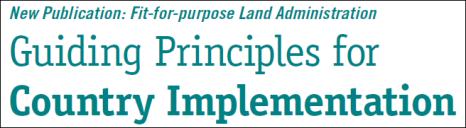
Fit-For-Purpose Land Administration: Developing Country Specific Strategies for Implementation Enemark, Stig; McLaren, Robin
 Aalborg Universitet Fit-For-Purpose Land Administration: Developing Country Specific Strategies for Implementation Enemark, Stig; McLaren, Robin Published in: Responsible Land Governance: Towards an Evidence
Global Campaign to Achieve 80% Security of Tenure by 2030
 Global Campaign to Achieve 80% Security of Tenure by 2030 Robin MCLAREN, United Kingdom and Stig ENEMARK, Denmark Key words: Fit-For-Purpose, Land Administration, Strategy for Implementation, Global Campaign
Aalborg Universitet. Fit-For-Purpose Land Administration Enemark, Stig; McLaren, Robin; Lemmen, Christiaan. Publication date: 2016
 Aalborg Universitet Fit-For-Purpose Land Administration Enemark, Stig; McLaren, Robin; Lemmen, Christiaan Publication date: 2016 Document Version Publisher's PDF, also known as Version of record Link to
Land Governance in Support of The Millennium Development Goals. Stig Enemark Paul van der Molen Robin McLaren
 Land Governance in Support of The Millennium Development Goals Stig Enemark Paul van der Molen Robin McLaren INV 1 - Land Governance in Support of the Millennium Development Goals Sydney, Australia, 11-16
GLTN LAND TOOLS -SOME EXAMPLES-
 GLTN LAND TOOLS -SOME EXAMPLES- Dr. Jaap Zevenbergen University of Twente What are GLTN Land Tools? GLTN considers that a tool is a practical method to achieve a defined objective in a particular context.
The LADM and the Continuum of Land Rights
 CheeHai TEO, Malaysia and Christiaan Lemmen, the Netherlands Key words: LADM, Continuum of Land Rights, Voluntary Guidelines, Spatial Enabled Societies SUMMARY The development of the Land Administration
Scenic Nepal. Land Administration Systems. Outline of Presentation. Interests in land. Rights: Registration and security of tenure positions
 Scenic Nepal Land Administration Systems Managing Rights, Restrictions, and Responsibilities in Land Prof. Stig Enemark President Aalborg University, Denmark SURVEY DEPARTMENT KATHMANDU, NEPAL. 16 FEBRUARY
A new era: Dynamic Information Management
 A new era: Dynamic Information Management Professional and Institutional Developments Kees de Zeeuw MSc Director Kadaster International The Netherlands Affiliate member s perspective 45 affiliates from
The Developing Role of the Surveyor in a Developing World
 The Developing Role of the Surveyor in a Developing World Paula DIJKSTRA 24-9-2018 FIG Seminar Cadastre in a digital world Nordic and Global Perspective Developing World requires reliable geospatial information
Land Administration in support of the Global Agenda: Current FIG Policies
 Land Administration in support of the Global Agenda: Current FIG Policies Prof. Stig Enemark President Aalborg University, Denmark FIG COMMISSION 7 ANNUAL MEETING VERONA, ITALY, SEPTEMBER 2008 Current
EXPERIENCES FROM THE KENYAN PROCESS
 EXPERIENCES FROM THE KENYAN PROCESS Contents: 1) Introduction: Kenya 2) Current Land Administration Practices 3) Consequences of Poor Practice 4) Context of Land Policy Formulation in Africa 5) Kenya National
Challenges for the multi purpose cadastre
 Jens RIECKEN, Markus SEIFERT, Germany Key words: Multi purpose cadastre, 3d-cadastre, land use, SDI, solar cadastre SUMMARY Over the past 30 years, with the progress of information technologies the development
The Surveyor and the Sustainable Development Goals
 The Surveyor and the Sustainable Development Goals Ghana Institute of Surveyors 12 th Surveyors Week Accra, Ghana, 20 th - 24 th February 2017 www.fig.net/ Dr Diane Dumashie, FRICS FIG Vice President How
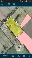
Implementation of Fit for Purpose Land Administration in Nepal, in a post disaster context.
 Implementation of Fit for Purpose Land Administration in Nepal, in a post disaster context. Paula Dijkstra, Raja Ram Chhatkuli, Danilo Antonio, Eva-Maria Unger, Chrit Lemmen Wondimagegm Tesfaye, Shristee
Low Cost Cadastral Data Aquisition?
 Low Cost Cadastral Data Aquisition? Jacobus Meijer and Christiaan Lemmen (Netherlands): 21 May 2011 Abstract Spatial Cadastral Data (Mapping) Participatory Development Some low cost approaches in cadastral
Commission 7 Cadastre and Land Administration. Work Plan
 Commission 7 Cadastre and Land Administration Work Plan 2011 2014 Appendix to item 17.7 1. Title Cadastre and Land Administration 2. Terms of Reference Commission 7 deals with land administration and land
Deqing International Seminar on United Nations Global Geospatial Information Management Effective Land Administration September 2018
 Provisional Annotated Agenda 08:00 a.m. 09:00 a.m. Registration of Participants Thursday, 27th September 2018 09:00 a.m. 10:00 a.m. Joint Official Opening Session Joint official opening session of the
FIG Commission 7 Cadastre and Land Management
 1. Title Appendix to item 13 FIG Commission 7 Cadastre and Land Management Cadastre and Land Management 2. Terms of Reference Work Plan 2015 2018 Commission 7 deals with all issues of land rights and land
Progress in modern cadastre Challenging existing models and paradigms
 Progress in modern cadastre Challenging existing models and paradigms Gerda Schennach, Austria Chair of FIG Commission 7 Federal Office of Metrology and Surveying, Austria The Value of Cadastre for Society
FIG Commission 3 Spatial Information Management. Report of Activities 2009
 Appendix to item 10.3 Report to the 33 rd General Assembly FIG Congress in Sydney, Australia 2010 FIG Commission 3 Spatial Information Management Report of Activities 2009 1. General Since 2007, FIG Commission
Greetings from Denmark. Property Rights, Restrictions and Responsibilities - A Global Land Management Perspective. Wonderful Copenhagen
 Property Rights, Restrictions and Responsibilities - A Global Land Management Perspective Greetings from Denmark 43,000 sq km Prof. Stig Enemark President Aalborg University, Denmark Aalborg Copenhagen
A beautiful setting. The Evolving Role of Cadastral Systems in Support of Good Land Governance. Setting the scene
 The Evolving Role of Cadastral Systems in Support of Good Land Governance Prof. Stig Enemark President Aalborg University, Denmark THE DIGITAL CADASTRAL MAP FIG COMMISSION 7 OPEN SYMPOSIUM KARLOVY VARY,
The Message FIG-WB Partnership on Land Governance in Support of the Global Agenda
 FIG-WB Partnership on Land Governance in Support of the Global Agenda Prof. Stig Enemark, Denmark President 2007-2010 Mr. Teo Chee Hai, Malaysia President Elect 2011-2014 WORLD BANK LAND GROUP, WASHINGTON,
Commission 7 Cadastre and Land Administration Report 2016
 FIG General Assembly FIG 40 th General Assembly Helsinki, Finland, May 29 June 2, 2017 Commission reports Commission 7 Commission 7 Cadastre and Land Administration Report 2016 General Remarks The Mission
Creation Land Administration in Formal and Informal Environment. FIG Commission 7 Working Group 1
 Creation Land Administration in Formal and Informal Environment András OSSKÓ, Hungary Key words: land administration, informal land tenure, customary tenure, sustainable Development. SUMMARY FIG Commission
The Bathurst Declaration on Land Administration for Sustainable Development
 United Nations and International Federation of Surveyors The Bathurst Declaration on Land Administration for Sustainable Development The Story The cumulative evolution of society s land administration
UNECE Working Party on Land Administration UNECE WPLA. Report on the work of the Bureau of the Working Party
 UNECE Working Party on Land Administration UNECE WPLA Report on the work of the Bureau of the Working Party 10 th Session of UNECE WPLA Geneva, 8 9 March 2017 UNECE Working Party on Land Administration
The Profession between Cadastre and Citizen
 The Profession between Cadastre and Citizen Gerda Schennach, Austria Chair of FIG Commission 7 1 A human right UN DECLARATION OF HUMAN RIGHTS Article 17 par (1) Everyone has the right to own property alone
Click to edit Master title style
 Click to edit Master title style Modern Cadastre and Land Administration Session 5a. The toolbox approach Jude Wallace 2007 Click to edit Overview Master title style Objectives To understand the circumstances
Land and the New Urban Agenda EGM June 2016
 EGM June 2016 Filiep Decorte Deputy Director New York Liaison Office UN-Habitat 2 August 2016 ROLE OF LAND IN URBAN DEVELOPMENT The New Urban Agenda is about people People need a place to live. Place means
LIS a motivation for SDI initiative
 Eric Mwaikambo Ardhi University Dar es Salaam Tanzania Overview Status of LIS in Tanzania Relationship between SDI and LIS Spatial Standards LIS a motivation for SDI initiative Conclusion & Recommendations
LAND TENURE IN ASIA AND THE PACIFIC CHALLENGES, OPPORTUNITIES AND WAY FORWARD
 LAND TENURE IN ASIA AND THE PACIFIC CHALLENGES, OPPORTUNITIES AND WAY FORWARD Workshop on Land Administration and Management 20th United Nations Regional Cartographic Conference for Asia and the Pacific
Esri Middle East and Africa User Conference. December Abu Dhabi, UAE. Land Administration. Mark Baker
 Esri Middle East and Africa User Conference December 10 12 Abu Dhabi, UAE Land Administration Mark Baker Our Agenda 0900 0930 Welcome Mark Baker, Esri 0930 1030 New Directions The New Addressing System
Responsible and Innovative Land Administration
 Responsible and Innovative Land Administration An Example from Ethiopia 3 RD DECEMBER 2018 Outline A few words about NIRAS Fit-for-purpose: A low-tech disruptive approach? The REILA Project in Ethiopia
COMMISSION 7 CADASTRE AND LAND MANAGEMENT WORK PLAN
 Appendix to item 34.7 FIG Congress in Washington, 19-26 April 2002 COMMISSION 7 CADASTRE AND LAND MANAGEMENT WORK PLAN 2002 2006 1. Title Cadastre and Land Management 2. Terms of Reference Commission 7
Supporting Capacity Development for Sustainable Land Administration Infrastructures
 THE EIGHTH UNITED NATIONS REGIONAL CARTOGRAPHIC CONFERENCE FOR THE AMARICAS (UNRCCA) 27 June 1 July 2005, United Nations Headquarters, New York Supporting Capacity Development for Sustainable Land Administration
Introduction to Land Tenure Administration
 Introduction to Land Tenure Administration Karol Boudreaux Land Tenure & Resource Rights Practice Lead, The Cloudburst Group January 22, 2018 January 22, 2018 1 WHAT WE LL COVER Background and Definitions
From LADM/STDM to a spatially enabled society: a vision for Harry UITERMARK, Peter VAN OOSTEROM, Jaap ZEVENBERGEN and Christiaan LEMMEN
 From LADM/STDM to a spatially enabled society: a vision for 2025 Harry UITERMARK, Peter VAN OOSTEROM, Jaap ZEVENBERGEN and Christiaan LEMMEN Introduction (1) Vision is a co-production Founding fathers
UNPLANNED URBAN DEVELOPMENT
 National Technical University of Athens School of Rural and Surveying Engineering UNPLANNED URBAN DEVELOPMENT Chryssy A Potsiou, Lecturer NTUA chryssyp@survey.ntua.gr UNECE WPLA WORKSHOP EFFECTIVE AND
Land Tenure and Geospatial Data and Technology
 Land Tenure and Geospatial Data and Technology Ioana Bouvier E3/Land and Urban, USAID Senior Geospatial Analyst January 23, 2018 January 23, 2018 1 OUTLINE 1. Overview of geospatial data and technology
Land surveying is probably the (second) oldest profession in the world
 oldest profession in the world") Land Surveying and Land Management in an International Perspective Prof Stig Enemark Honorary President Aalborg University, Denmark CADASTRE IN A DIGITAL WORLD NORDIC AND GLOBAL PRESPECTIVES INTERNATIONAL
Land Surveying and Land Management in an International Perspective Prof Stig Enemark Honorary President Aalborg University, Denmark CADASTRE IN A DIGITAL WORLD NORDIC AND GLOBAL PRESPECTIVES INTERNATIONAL
EU Urban Agenda Housing Partnership
 EU Urban Agenda Housing Partnership Information for EU-institutions, cities, stakeholders, interest groups and NGOs State of Play as at 24 March 2017 Charter of Fundamental Rights of the European Union
How Big is Global Insecurity of Tenure?
 Presented at the FIG Working Week 2016, May 2-6, 2016 in Christchurch, New Zealand Know Edge Limited Location Information Innovation How Big is Global Insecurity of Tenure? Dr Robin McLaren Know Edge Ltd,
Centre for SDIs and Land Administration Department of Geomatics Spatial systems to support sustainable development
 Centre for SDIs and Land Administration Department of Geomatics MODERN CADASTER and LAND ADMINISTRATION تهران-مرداد 1386 2014 ..... 2 ماه Centre for SDIs and Land Administration Department of Geomatics
REPORT ON UN-HABITAT ACTIVITIES REGARDING INDIGENOUS ISSUES
 REPORT ON UN-HABITAT ACTIVITIES REGARDING INDIGENOUS ISSUES Submitted to the Tenth Session of the Permanent Forum on Indigenous Issues 16-27 May 2011, United Nations, New York Executive summary UN-HABITAT
New Technology for Cadastral Systems. Brent Jones, PE, PLS
 New Technology for Cadastral Systems Brent Jones, PE, PLS Benefits of Good Land Administration Key to addressing global challenges.. Secure Tenure Equitable Land and Property Taxation Support for Government
FIT-FOR-PURPOSE LAND ADMINISTRATION
 FIT-FOR-PURPOSE LAND ADMINISTRATION A COUNTRY LEVEL IMPLEMENTATION STRATEGY FOR NEPAL SECURING LAND AND PROPERTY RIGHTS FOR ALL SUSTAINABLE LAND MANAGEMENT, PROSPEROUS LIFE AND DEVELOPMENT Government of
FIG and FIG Commission 7 Topics of interest
 FIG and FIG Commission 7 Topics of interest Chair FIG Commission 7 Cadastre & Land Management 1 What is FIG? Interna tiona l Fed era tion of Surveyors Féd éra tion Interna tiona le d es Géom ètres Interna
THE CONTINUUM OF LAND RIGHTS
 THE CONTINUUM OF LAND RIGHTS Clarissa Augustinus, GLTN/UN-Habitat FIG Working Week, Sophia, Bulgaria, 17-21 June 2015 THE CONTINUUM OF LAND RIGHTS APPROACH Recognising, Recording, Administering a variety
Flying high and Keeping the feet on the ground
 Building the Capacity The Agenda and Achievements 2007-2010 FIG handover ceremony, FIG headquarters, Copenhagen, 26 November 2010 The Agenda Building the Capacity through Flying high and Keeping the feet
Rapid Urbanization What can land surveyors do? Paul van der MOLEN. % (millions) % Rural ,974 3, ,
 % Rural ,974 3, ,") Rapid Urbanization What can land surveyors do? Paul van der MOLEN What is it all about? population World Urban % Rural % (millions) (millions) (millions) 2011 6,974 3,632 52.1 3,341 47.9 2050 9,306 6,252
Rapid Urbanization What can land surveyors do? Paul van der MOLEN What is it all about? population World Urban % Rural % (millions) (millions) (millions) 2011 6,974 3,632 52.1 3,341 47.9 2050 9,306 6,252
Key Concepts, Approaches and Tools for Strengthening Land Tenure Security
 Key Concepts, Approaches and Tools for Strengthening Land Tenure Security Dr. Samuel Mabikke Land & GLTN Unit / UN-Habitat Urban CSO Cluster Learning Exchange on Strengthening Land Tenure Security for
Cadastre A Vision on Future Cadastral Systems
 Cadastre 2014 - A Vision on Future Cadastral Systems Jürg Kaufmann - 1 - CONTENTS ABOUT FIG ENVIRONMENT FOR THE DEVELOPMENT OF CADASTRE 2014 DEVELOPMENT OF CADASTRE 2014 PRINCIPLES OF CADASTRE 2014 EFFECTS
Regulation. Deregulation
 Regulation of liberal property surveyors profession vs. Deregulation requirements for growth and competition - - - - Henning Elmstrøm President: The Danish Association of Chartered Surveyors (DdL) Torben
Expert Group Meeting 9-11 November 2005 Geomatics The University of Melbourne Centre for Spatial Data Infrastructures and Land Administration
 Incorporating Sustainable Development Objectives into ICT Enabled Land Administration Systems Australia s International Science Linkages Program Expert Group Meeting 9-11 November 2005 Geomatics The University
LADM-based Crowdsourced 3D Cadastral Surveying Potential and Perspectives
 National Technical University Of Athens School of Rural and Surveying Engineering LADM-based Crowdsourced 3D Cadastral Surveying Potential and Perspectives Maria Gkeli, Surveying Engineer, PhD student
FIG e-newsletter July/August 2013
 International Federation of Surveyors Fédération Internationale des Géomètres Internationale Vereinigung der Vermessungsingenieure FIG e-newsletter July/August 2013 Dear Colleague, Welcome to the FIG e-newsletter,
The Digital Cadastral Database and the Role of the Private Licensed Surveyors in Denmark
 IRISH INSTITUTE OF SURVEYORS, DUBLIN INSTITUTE OF TECHNOLOGY, 23 NOVEMBER 2005 PUBLISHED IN IIS NEWS, WINTHER 2006. The Digital Cadastral Database and the Role of the Private Licensed Surveyors in Denmark
CADASTRE 2014: New Challenges and Direction
 CADASTRE 2014: New Challenges and Direction Anna KRELLE and Abbas RAJABIFARD, Australia Key words: Cadastre, Cadastre 2014, Land Administration SUMMARY Land and land related activities form part of the
Working Group 3 Application of Innovative Technology
 COMMISSION 7 Working Group 7.3 Annual Meeting Seoul, 18-23 May 2007 Working Group 3 Application of Innovative Technology Dr. Daniel Steudler Swiss Federal Directorate of Cadastral Surveying Table of Content
Fit-for Purpose Approaches to Land Administration
 Fit-for Purpose Approaches to Land Administration Brent Jones, PE, PLS Global Manager, Casastre/Land Records bjones@esri.com Land Administration GIS is the platform for land administration Land administration
The ISO/TC 211 Land Administration Domain Model (LADM)
") Geographic information/geomatics The ISO/TC 211 Land Administration Domain Model (LADM) Harry Uitermark/Editor LADM Kadaster/ITC, The Netherlands International Organization for Standardization (ISO) A
Geographic information/geomatics The ISO/TC 211 Land Administration Domain Model (LADM) Harry Uitermark/Editor LADM Kadaster/ITC, The Netherlands International Organization for Standardization (ISO) A
BEYOND LAND TENURE REGULARISATION: ACHIEVING SUSTAINABILITY. RICHARD BALDWIN, CLIVE ENGLISH, GAVIN ADLINGTON DAI Europe Ltd
 BEYOND LAND TENURE REGULARISATION: ACHIEVING SUSTAINABILITY RICHARD BALDWIN, CLIVE ENGLISH, GAVIN ADLINGTON DAI Europe Ltd Richard_baldwin@dai.com Paper prepared for presentation at the 2016 WORLD BANK
FIG Working Week 2008 and XXXI. General Assembly, Stockholm, Sweden, June FIG Commission 7 Annual Meeting 15 September 2008
 FIG Working Week 2008 and XXXI. General Assembly, Stockholm, Sweden, 14-19 June 2008 András s OSSKÓ FIG Commission 7 Annual Meeting Verona, Italy, 11-15 15 September 2008 The Working Week held in Stockholm,
GLTN Tools and Approaches in Support of Land Policy Implementation in Africa
 GLTN Tools and Approaches in Support of Land Policy Implementation in Africa Jamal Browne (UN-Habitat), Jaap Zevenbergen (ITC), Danilo Antonio (UN-Habitat), Solomon Haile (UN-Habitat) Land Policy Development
Spatially Enabled Society Role of the Cadastre
 armasuisse Bundesamt für Landestopografie swisstopo Swiss Federal Directorate for Cadastral Surveying Spatially Enabled Society Role of the Cadastre XXIV FIG International Congress 2010 FIG-Task Force
REGISTRATION OF PROPERTIES IN STRATA
 REGISTRATION OF PROPERTIES IN STRATA REPORT ON THE WORKING SESSIONS INTRODUCTION A cadastre is usually, and in most countries, a parcel-based, and up-to-date land information system containing records
Spatial Enablement and the Response to Climate Change and the Millennium Development Goals
 Spatial Enablement and the Response to Climate Change and the Millennium Development Goals Prof. Stig Enemark President Aalborg University, Denmark 18th UNITED NATIONS REGIONAL CARTOGRAPHIS CONFERENCE
STATUS REPORT
 Working Group 3 Land Administration STATUS REPORT 2006-2009 2009 Prof Ian Williamson (Chair) Mr Ahmad Fauzi Nordin (Vice Chair) Assoc. Prof Abbas Rajabifard (Vice Chair) 18th UNRCC-AP Conference Bangkok
Spatial Data Infrastructure for knowledge sharing
 , THE NETHERLANDS Key words: SDI, knowledge sharing, people profit planet, Kadaster, system of key registers, good governance, e-government, spatially enabled society, GIDEON SUMMARY Today s global challenges
Importance of Spatial Data Infrastructure in the UNECE Region. Amie Figueiredo INSPIRE Conference 2016 Barcelona, 26 September 2016
 Importance of Spatial Data Infrastructure in the UNECE Region. Amie Figueiredo INSPIRE Conference 2016 Barcelona, 26 September 2016 United Nations Economic Commission for Europe 56 member States in Europe,
Development of legislation for earthquake affected. cadastral boundaries in New Zealand. FIG Geoconference Cadastre 4.0, Coimbra Portugal
 Development of legislation for earthquake affected cadastral boundaries in New Zealand Associate Professor Dr Don Grant RMIT University FIG Geoconference Cadastre 4.0, Coimbra Portugal 26 October 2016