D OWNER'S AGENT D PROPERTY OWNER ~CONTRACT PURCHASER
|
|
|
- Clarence Baldwin
- 5 years ago
- Views:
Transcription

1 Gwinnett County Planning Division Rezoning Application Last Updated 12/20 S REZONNG APPLCATON AN APPLCATON TO AMEND THE OFFCAL ZONNG MAP OF GWNNETT COUNTY, GA. APPLCANT NFORMATON PROPERTY OWNER NFORMATON* NAME: US Land nvestments, LLC NAME: REO Funding Solutions V, LLC, AD:rsf 6Tdtsfl't131vd., Suite 4000 ADDRESS: 1170 Peachtree Street NE, Ste 1150 city: Duluth city: Atlanta STATE: GA ZP: STATE: GA ZP: PHONE: (770) PHONE: ( 404) CONTACT PERSON: Marian C. Adeimy, Attorney PHONE: (770) CONTACT'S E-MAL: madeimy@atclawfirm.com APPLCANT S THE: D OWNER'S AGENT D PROPERTY OWNER CONTRACT PURCHASER PRESENT ZONNG DSTRCTS(S): C 2 /0& REQUESTED ZONNG DSTRCT: R-TH R B, R D, R PARCEL NUMBER(S): ACREAGE: ADDREss of PRoPERTY: 425 Stone Mountain Hwy. PROPOSED DEVELOPMENT: Townhomes (to complement existing commercial uses) RESDENTAL DEVELOPMENT NON-RESDENTAL DEVELOPMENT No. of Lots/Dwelling Units _1_6_2 No. of Buildings/Lots: 22ft wide, min. 1,500 sq. ft. Dwelling Unit Size (Sq. Ft.): Gross Density: 6.09 Units/acre Net Density: 9.2 Units/acre Total Building Sq. Ft. Density: PLEASE ATTACH A LETTER OF NTENT EXPLANNG WHAT S PROPOSED 2 RZM 'loo 9 R CEVED BY OCT Planning & Development

2 Hwy 78 and Lowes Tract - Survey Description All that tract or parcel of land lying and being in Land Lots 57 and 62 of the 6th Land District, Gwinnett County, Georgia, and being more particularly described as follows: Commencing at a point formed by the intersection of the northerly right of way of U.S. Highway No. 78 (100 foot right of way) and the westerly right of way of Puckett Road (80 foot right of way), said point being the Point of Commencement; THENCE along the right of way of U.S. Highway No. 78 North 77 degrees 26 minutes 04 seconds East for a distance of feet to a inch rebar found, said point being the PONT OF BEG NNNG; THENCE leaving the said right of way North 47 degrees 28 minutes OS seconds West for a distance of feet to a inch rebar found; THENCE North 40 degrees 59 minutes 34 seconds West for a distance of feet to a 1 inch open top pipe found; THENCE South 63 degrees 41 minutes OS seconds West for a distance of feet to a % inch open top pipe found; THENCE North 30 degrees 01 minutes 00 seconds West for a distance of feet to a 2 inch open top pipe found; THENCE North 30 degrees OS minutes 50 seconds West for a distance of feet to a 1 inch square tube found; THENCE North 29 degrees 40 minutes 22 seconds West for a distance of feet to a 1 inch square tube found; THENCE North 29 degrees 48 minutes 37 seconds West for a distance of feet to a % inch open top pipe found; THENCE North 28 degrees 50 minutes 32 seconds West for a distance of feet to a % inch open top pipe found; THENCE North 29 degrees 44 minutes 31 seconds West for a distance of feet to a% inch open top pipe found; THENCE North 30 degrees 18 minutes 23 seconds West for a distance of feet to a point; THENCE North 31 degrees OS minutes 14 seconds West for a distance of feet to a point marked in a rock found; THENCE North 60 degrees 39 minutes 42 seconds East for a distance of feet to a 1 inch rebar found; THENCE North 60 degrees 21 minutes 28 seconds East for a distance of feet to a 1 inch rebar found; THENCE North 60 degrees 50 minutes 09 seconds East for a distance of feet to a 1 inch rebar found; THENCE North 60 degrees 47 minutes 14 seconds East for a distance of feet to a 1 inch rebar found; THENCE North 60 degrees 28 minutes 29 seconds East for a distance of feet to a 1 inch rebar found; THENCE North 61 degrees 11 minutes 47 seconds East for a distance of feet to a 1 inch rebar found; THENCE North 61 degrees 17 minutes 39 seconds East for a distance of feet to a 1 inch rebar found; THENCE North 60 degrees 04 minutes 27 seconds East for a distance of feet to a 1 inch rebar found; THENCE South 23 degrees 42 minutes 53 seconds East for a distance of feet to a inch rebar found; THENCE North 63 degrees 52 minutes 06 seconds East for a distance of feet to a inch rebar found; THENCE South 30 degrees 08 minutes 48 seconds East for a distance of feet to a inch rebar found; THENCE South 66 degrees 17 minutes OS seconds West for a distance of feet to a inch rebar found; THENCE South 23 degrees 42 minutes 16 seconds East for a distance of feet to a punch hole found in a concrete curb; THENCE South 66 degrees 18 minutes 28 seconds West for a distance of feet to a inch rebar found; THENCE South 13 degrees 34 minutes 28 seconds East for a distance of feet to a inch rebar found; THENCE South 66 degrees 18 minutes 23 seconds West for a distance of feet to a inch rebar found; THENCE South 12 degrees 40 minutes 53 seconds East for a distance of feet to a inch rebar found on the northerly right of way of U.S. Highway No. 78; THENCE along the said right of way South 77 degrees 20 minutes 28 seconds West for a distance of feet to a inch rebar found; said point being the PONT OF BEGNNNG. The above described t ract contains Acres. CEVE 0 ( r 2.01
.lndll!o\"w'\ll'llyrilllltof w...,nfpok.kl'llllo.ld(!of JOtr\tlhtnf w.-,.,).utdpnlnt bei!\fl t h flolnt of Comm 'llt!lmnt : TH NC 61onc the rl(!l1! of w v of U.")
3 Al!thatH.lctorp:rcd ofl,.,d lyln ;:md bel nlllnl;lr dldt$57and 52o f:hc6"'l1ndo!mtct.ciwlrntll Cnmmrndn1 oa1 1'1 point lormrd hy thf" lntr.rvttl<"'n nl thc- nnni-c'rly r11h1 n l w:ro, of LJ.S H11hw.:ty No. 711 ' UOMt rlfthlnf,..,ly).lndll!o"w'\ll'llyrilllltof w...,nfpok.kl'llllo.ld(!of JOtr\tlhtnf w.-,.,).utdpnlnt bei!\fl t h flolnt of Comm 'llt!lmnt : TH NC 61onc the rl(!l1! of w v of U.5 Hln hw v No. 78 North 77 dccrt'i!» 21i mlr-utt 04 Kond E:l)\ r : tllnm:t of J53.69 fi!c: to a inch re!j;!r found, :.a d pglnt bcll\flthep O NTOBCGNN NG; THE NC le:tvlnqtlle uid rlbt t of way North 47 M!Jet!. 2.!1 mlnutc5 05 ucond Wtst for.11 diu.lntc of 106.!10 re11t to 01 nch b :u found: THE Net: North 40 dcnret) S? mir1utu 14 onds West for tfl,l.1nt,.nf4f.0 71i 1-t to ll linch np"n top p1rwofoun.ct;th Na: Snuth &1d'"ll,...41 mlnur,..or; c-on:!.w t o r:dln:.nceoi i41 0Sfcet:o01!i:lnc:hopt"nto p plpelound; T H N C[Nonhl0d t-jirt: C'5 01 mlnuto 00 seconds West lo r a dunce of ll,.lli feet to 2 nch opel"l top pipe foun:l; TH i:nct: North JO dtjrhj O:t mlf"llltu SO l«<nd!. Well for 11 do!.unct of lolsl lut to.11 nch Jqulrt lube found, TH[NCE North 1!1 dtrrffi <10 mlf"lu1 l 2l 1KO'ds Wr.:t for dlnaf"lta of let-t :o 1 if"ch W!U:Jrc tube louncf; THCNC[ North l9 dearea4! mi, UH 37 JKO'd) Wut!or 11 d1u011"tf! of l20.0l lett tn M lf"lt h op"""' tnp plpl' ff'llmrl ; TH fnc Nnr\1"1111 rl ll'j:;rh". SO minj\1'"1. " WM.t for 1!1\t.lf"'l'..l' of9).1j5 let-t to!< lrdl opel' lop pipe fotmd; fii[ncc: North M dc&rfttl 14 mmu!n Jl srconds Wts.t f or.11di t.antool!ll.!)4 f tct t o l'inti"o)('f"ltop$lf round ; THENC"<:NorthJOd e,rf!c'ollm1n u tes 2l co"dsweufor dllt&f"ceof!ll. 12futtopoll"lt;Tl i CNCE:NorthlldeiiNiOSmlf"Uitill\e<ondl We1.t for dk!af'll:e of 1450!1 feet to.a point m11rl.:ed n 01 rock fourd. THENCE North r.o lkl!rtcs l mlnutes42 ccondi[:utfor ldlstanteof99.88 fet>tto.jllnch rebtwloun:: T"H NC Northli0dtfrl!ti '-' mlotulr.\ nt l!f.n i'cb F11. t fly 11 dl ta nc,. n l t-o"! tn 11 1 Jodi rrb.u fnuntl: l"hfntf Nnrth fio d"l\ri" U S0mil'lu t O'l\<'1'M"d\C\\fnrllrli1. on tf'nl'lll. 'l t l,...ttoint.h,.hmfnould; TH r.'_,c.[nclrlh 60doeR!"' 47mll'u1e.J! \ordjcau tor.jd1 tanceof!y.l6l leettoallnth r ebrtllound ; TH CNct: Notth 60 de11rees 21 mlf"uttu 2 5t-eondl C st for dli!llnce of!1").76 feet to 1 linch reb r lourd: TC NC. Nonh & dl!& l ll 11 minute 41 '-econd Cnt for distance of n: to linch reb:n fnund;t fncrnnrlhci l llll'l'""'t7m l nuti' \.11JMt-c:nnd\ (.\ \:for,orij, tllr c,.of9 1 fll'"ltf"ln t lnr.h r,.h.. l nuntf:l ll fcf.nnrt h r.oif"'b '""""().mlnll!l'\71 ton d,\ C.:tMim lfl\tt>rc,.o l \ l "' "''o l lh,.._lf rnund, THFNC.F!oonut h Jllfi ltl" '*" "' minlltr: Sl \M.Ond r,ntlm;, Ul\t:.m:r. of 1J!.Hi fn!t to a K nch rebar fourd: Tt tcncc No rt h r.:l dtlii!c' 51 m\rlu:s 0Gsec011d c ot for a dbtance o' fc-c:t t oo K "th r!lb:rlound ; n t tnc C So ut hlodevee OBmtnutes"-ttD"ld\[:lllfor::adkt :ma:of 1 1Jl27 feet :o a lnctl rebar found: T![NCC South GG deree1 17 mlnu1es 0::. cord$ We" for " dltlllnc-t. of ft to li nch bar foul'ld, n tcnc{ South :!l drecj 42 mlnutn t G skords tan for a dbtal"lteois9-.!!ofc-c:t to.llpunchhole louf"ld ln.ltonue:.r:c\6b: THENCESouth66dell'tt)l8ml"utn 28s.c:cor.dWe!.l "orldlst.lllceotloo.o'itretto.:t:.lo lnth re-b.:tr found; THEtlCESou:h lldrec ll i mlnutrjill:tllrds(:tl:tfor.jdlst.:trc;eof i L.ll ee:toll l\ lnchrerfound ; T >tencesouth66dc1(rtn 11! mlrtjlo'\ H \Ntmd\ \\1,.\l tor ;o,!umf"l(t' ot ll'et 11"1 11 to', lnr.h lt'bm found: lhf, CF o;n.,,, 11 dr.jri"c\ ll mlnutu S.l \Onth FM! '"' 11 di\uoncr: nl 14L51!f"el to 11 X lnctl rrbnr lf"luf"ld on Thf' norther1yrl&l"l:olw yoiu. S.H l ct >ol,)yno. 7.!1 ; T-ENC alll\t'u i drli:ti:d.jvsoutl171 d ei!j'tt's20 :;::!:'" " for.., dhi:.nt:l' of r_..,, t o:. tom '"'b.l' found;.utd pomt lw. "G th,. \ \ BOUNDARY SURVEY FOR: U.S. LAND NVESTMENTS, LLC EXSTNG TAX D LAND LOTS 57 AND 62 OF THE 6TH LAND DSTRCT OF GWNNETT COUNTY, GEORGA SUBJECT REFERENCE DEED BOOK 53271, PAGE 666 AREA OF SUBJECT PROPERTY ACRES -.,..._d}"''..'q - ri;,.. 119'",:?.. 4. j!sj,. /}._, "' / (.:'1- f cl;' s, o1tt-sr1m:r{.t.lirf:1d RlM 'J6009 \ RE EVED y OCT Janning & Development ;f' \ _,..,.<:j,- (; \ J' / "'D([lll'Or<PQ(OtUCr ocuw 7 '{)( / -\ ""1. OdWU.A!m<**Ot.\, '" NC l111.PC !" p- $"" 'i:!l' SUBJECT PROPERTY o 2 r!o S:u:S LLC Jll1;l 71- OCT(NO"'ONO l '"" nc:ct"o'ut'f W. 19(SUL(CDtlSl lol tlri!s COitiUCJrl AltUS. AND (Sfllth'l{ CO'f{NNS H o\ojac(nl PftJ'UT('SHA.Y{«<TSNCMit<llf()l f()t!(scqp(.u01'\.11pos rto'5s.av[' QTlD" l\l(lloii'o'ttlf;hslii(o(pcitd (NHSKJ..N).Ln5UYC'', Tt(SJM'TO (SS[])(VJ(!C(f#ADOifiC)O.t.Ot5 CU.Ott.C>5101N.'D:,wA[t,u(01H{Ltftii"(S 1Wr1T Dl" M Ubllf(5 A'PUJ TO 50M 'U. l"t{jp(t(su fi[uus(or n itt.a6jw OM.J!( l{li(<()aaltd:o\ctused FLOOD NOTE S!t rnrl.js llf""tf M'MTT riicirl:lln" LE.\ " 1\ Tli'_\T;S\Tl:O rfrti\lf!uo,\l,\d\rt!a r t! " SN f.t l.t 'o"tyro t i\".d M\PSU tll l' ll ll'" Ot>\1" MTt't> - =1 - : ntl "',,, LDl.JLUQfG.\,U.C 09!loJ6 40. PC. H laxo -OG2-n8 / SYMBOL LEGEND :. : ;:: PPO CD TRArnCPOL TUf"J"CPQST ::: Tyr:rfH:: 0 N: :r:er L[C1rt!C. : ntl([c(pt)ll lfc!ll ru,[ht()tan..:: :;: ;Pl( 0:..,:;.cv:_:o;;o :jlj,,,: Fr;j.(: s= UTLTY LEGEND ----u>- VNO[OUD POWER LCS -OHP-OY(AH(Ai)POW[ALN(S - 00-UNOC!CROJNOCASltN[ -5S-UN0[1K:.ROUN0s-,ARTSEW AUNCS -WU(t- UNC[ tcaou...,ow,t,t[litl(s -[L[-U"ff[CilOUNOT[L[PHONCOC[)t..UNCATONLN[S -01-it-ovtRH(..t.OitU:PHO"'[OACO"'oi UN!CA.llO"'liN(S SUN Y W.\S PfU'U[D W anto"t 111 nt: ftoncj.l51.t.hoadsropop{tyslll\('r5!c(o'!oa45s(tcjtt... OiAPftlf lll0-7 rl MlfU.lSCFfKC(QitQAOJ.!Of71(CSUO TOitPC1CSSOA.[lr01{("15AC)lANJ ANJ ASS{fCJtTWit<C(OO A AC H{51..8.(C'AOPOTY!S U[JSntC U PJ!({L AD1CJ1S11Dlltl.t.l. TO ( {COit!XD lllnt n Q.lft:Soma..!:;;;s,,::-... LMAAAG 2. lm! J"CLD DATA W1«:H "n. loiu' OR T...0 HAl A C...Oalil! ri''oof... a71put.umwammlu.taot.wu. a. Tte HOfiiZDN"fAl AlC) VBmCAl DAT"M 'Ofl WMCH TM M.atftY aa.o WA OlfU«D n n. tae Of' QN. A OV.WON,_TWOC 11111: M)Ya WAa UUD fo CClU...rOfCTm...,..'tiD Y A MAl n.ejctwom Of'!JUTmnEOPa80U10M.,C. <. TM"'-AfHAftNCALeta..ATD'CWCloaL\eAC)TteC.Atolll! 'OLDOloiR.t.CHTllACfLAa!l... L n. MQHT Of' WAY.cJWV )CMCN WA CAftD,_., DC:D AJrC) 1'\.ATa O'MCOf!DAtea,ot.M>.. -n.l'all. L TM!..., -- la TO AN! TN1 "'-Af. aand.'on MAD-U, ClllOMXA TAT1! ""'-ANl. WUT ZOC Ta ALL OMCnotll AJC) -THOWN'CMONAEAMC.C)T"Ofr401'llCYT"DA. 7. TM &MftY WA ""'"MD wrt110ut M Cnf 0' A mu DAWU.T!Oiol WAn..- WAY XJa1' -mat AmCT lm! -..ct -mat Allll NOT STATE WATER NFORMATON STAT( WAT(S WA Y (lust 01<.1 THS ST( AND TH( SUB.J[Cl PAOPCifi"T l.l,t,"t 0[ SUBC 10 (SCTlONS Atro BUrT(tS THM,t,ttl[ NOT SHOWN H[[O. "no( SUV("TOif toc.,t, TtD T-l[ C[N TUUW[ 01" A Clf[[C r()ll TH[ 'A(PA\",t,TQ«l Of!HtSSUit\[YH0111'[V( TH[CttlttltLDC,t,ONH(tti(O<SN01,t,NATT(WPT OD[ltN[AT(STAl[WAT{RS. H[SlJRV(TORR(COUU[WDSAO[UN[AONOf All STAT( WU[S ON ST[ Bti'OA[ ANYPLANNNC, CUO!<.COA 0.[-'A'<C ACflV Tt[S.!..:?l LAO"'C(XCAV,t,flON. nl{[xaclocailono"u<.ocacacljnor(av't(s CANH018(ACC\JR,t, T[LY.Cow>l.[l[LY.AN011(UA8LYO(Pitl(O tnaooton. NSQ.[.J.JliiSOtC.TlONS. QaOTHtASWLAAU Tll.l f'loc.at[a[ou[st r q()l,l n-r[ SJll\l[yt)q l.l,t,y8[ CNOR[O OA[SUll NA"' \C OUPL[T( tti[sp0ns[. "M1[ttl[,t,00!110N,t,LM UO'[O[T,t,lL(01NfM iol,t,\onsr[0uf[0, ina :S EXCAVATON,t,NQ/OR A l>qtvatt UTLTY LOCAl[ T._SSUftV(''WASPit[PAit[0'MT-OUTTH[8[N[fl10fAPiflVA[Uilttf'll LOeAT[. "' u O! " roi 0 * 8 ;;.; u:. = < ;z in :e or :1 0 DRAFT COPY e r-: -- 8 a g : g i cil 0... > > ;J lil u ::j g tl'.i :::::) SHEET: lofl '----

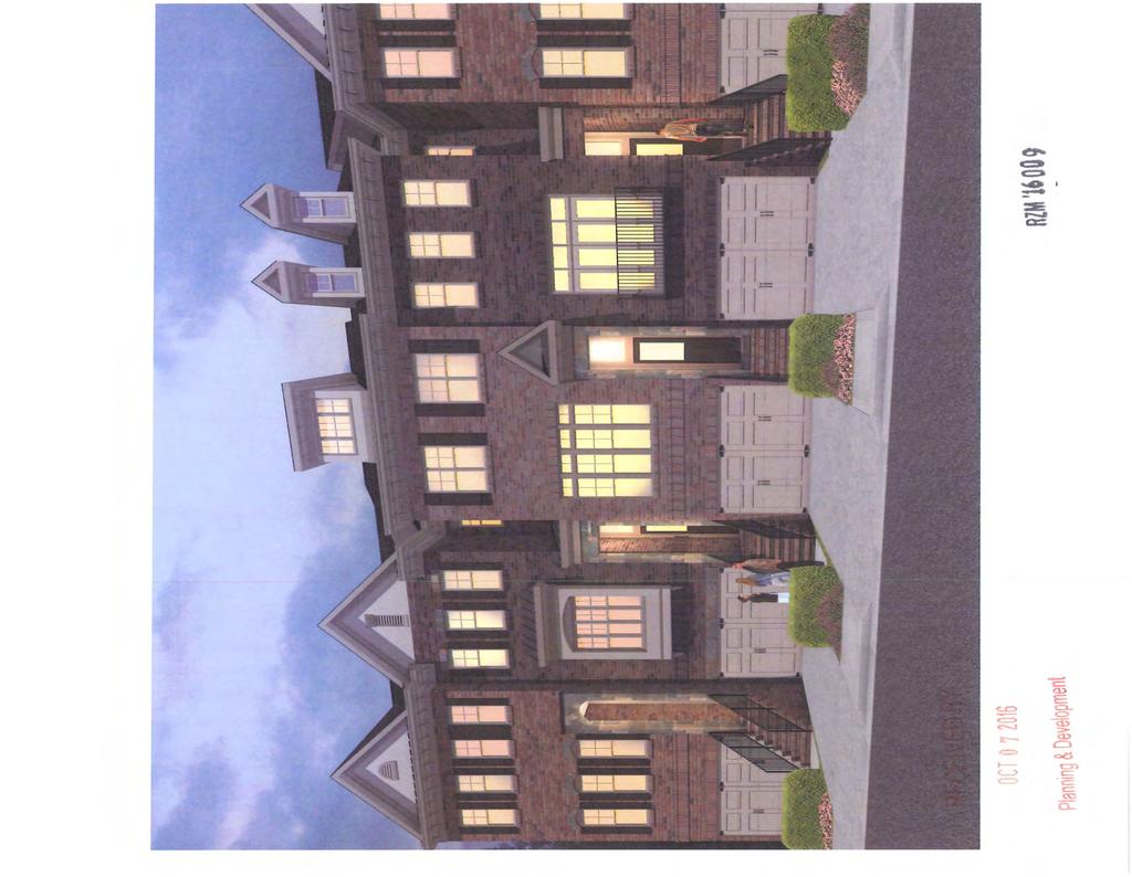
4 TYPCAL LOT LAYOUT REAR ENTRY ' RJ)' /. y / --..,!!'! Cl STE LOCATON MAP rt<>"',:.;,o>tf.st""" ' '\ Cl \ '* \... JM CNG CONSULTNG l CEEl.O'MEHTAD\SBS l l L... OM LktNC!COU-1, 5Un'!UC O W Ok l lu, CA l UJ t, l " lii H11 t. Ul-S41-1!11 OWNER/DEVELOrER: US LAND NVESTMENTS S!CON'D A V!. NOl111 SUTE 106 URMNCHAM, At PHONE: (770) HOUR tontatn WALT RABERN (770) l'lttjj lictl PARKHAVEN STE DATA Site Area: AC Existing Zoning: C2 & 01 Proposed Zoning : R- TH Total Lots: 162 (Rear Entry) [Blue]: 83 ( Fron t Entry) [Red]: 79 Density: 6.06 Units/ Acre Linear Feet Of Street: 4,132 LF Common Space: AC (344%) Detention Facility: AC LOCATED N: LAND LOTS 57 & 62 61h DSTRCT, lsi SECTON, GWNNETT COUNTY, GEORGA REZONNG EXHBT RZM '1, 09 RECEVED BY OCT 2016 P\ann\ng & Oeve\opment SHEET: co.oo
 > Q) 0 o6 t:::n c:: c: c:: co o_ a-.")
5 -<=> C"-1 Q f-. u 0 c: Q) E Q) > Q) 0 o6 t:::n c:: c: c:: co o_ a

6 8144f678-4ca ac43-fD4618a220cb.jpg (JPEG mage, 1602 x 1068 pixels)- Scaled... / RECEVED BY OCT RZM ' of 1 Planning & Development 1017/ :39 AM
7

8 nnage_buu_ 4)U.Jpg ljyt.v lmage, ouu x 4)U ptxels) ECEVED BY OCT anning & Development RZM ' of / :33 AM
9 din1ng bedroom- 2 bedroom- 3 great room /.1' k 1itchen garage (' / '... covered osy OPT PORCH mas"ter 1 J edroo '-- _./ First F1oo RZM ' \ann\ng & oeve\opment Second F/oo
10 , dining bedroom-2 bedroom-3 -- "' "' master ', ( ) bedroo m greatroc m l ' ' garage RECEVED B ) " A\cis-tu-, " (bedroom '1 l )... "... "' '-- -../ " " u 11 " > (bedroom l ' ' ' /"' ) First Floo RZM '16009 JC r o :Jianning & Development Seco nd Floo 3 Bedroom OtJtion Second Floo Dual Matster Ob,tio
11 Gwinnett County Planning Division Rezoning Application Last Updated 2/20 5 REZONNG APPLCANT'S RESPONSE STANDARDS GOVERNNG THE EXERCSE OF THE ZONNG POWER PURSUANT TO REQUREMENTS OF THE UNFED DEVELOPMENT ORDNANCE, THE BOARD OF COMMSSONERS FNDS THAT THE FOLLOWNG STANDARDS ARE RELEVANT N BALANCNG THE NTEREST N PROMOTNG THE PUBLC HEALTH, SAFETY, MORALTY OR GENERAL WELFARE AGANST THE RGHT TO THE UNRESTRCTED USE OF PROPERTY AND SHALL GOVERN THE EXERCSE OF THE ZONNG POWER. PLEASE RESPOND TO THE FOLLOWNG STANDARDS N THE SPACE PROVDED OR USE AN ATTACHMENT AS NECESSARY: (A) WHETHER A PROPOSED REZONNG WLL PERMT A USE THAT S SUTABLE N VEW OF THE USE AND DEVELOPMENT OF ADJACENT AND NEARBY PROPERTY: See Exhibits (B) WHETHER A PROPOSED REZONNG WLL ADVERSELY AFFECT THE EXSTNG USE OR USABLTY OF ADJACENT OR NEARBY PROPERTY: See Exhibits (C) WHETHER THE PROPERTY TO BE AFFECTED BY A PROPOSED REZONNG HAS REASONABLE ECONOMC USE AS CURRENTLY ZONED: See Exhibits (D) WHETHER THE PROPOSED REZONNG WLL RESULT N A USE WHCH WLL OR COULD CAUSE AN EXCESSVE OR BURDENSOME USE OF EXSTNG STREETS, TRANSPORTATON FACLTES, UTLTES, OR SCHOOLS: See Exhibits (E) WHETHER THE PROPOSED REZONNG S N CONFORMTY WTH THE POLCY AND NTENT OF THE LAND USE PLAN: See Exhibits (F) WHETHER THERE ARE OTHER EXSTNG OR CHANGNG CONDTONS AFFECTNG THE USE AND DEVELOPMENT OF THE PROPERTY WHCH GVE SUPPORTNG GROUNDS FOR ETHER APPROVAL OR DSAPPROVAL OF THE PROPOSED REZONNG: See Exhibits 3 RZM ' OCT y lan inq & Development

12 EXHBT "8" APPLCANT'S RESPONSES N SUPPORT OF REZONNG A) WHETHER THE REQUESTED REZONNG WLL PERMT A USE THAT S SUTABLE N VEW OF THE USE AND DEVELOPMENT OF ADJACENT AND NEARBY PROPERTY: Yes. The proposed residential development completes this property by providing for a mixed use development consistent with the nearby uses, with easy access to Highway 78. The proposed residential development and rooftops will support the nearby businesses, retail and commercial uses, and are consistent with the 2030 Unified Plan, which identifies this property as being in a Mixed-Use Corridor. B) WHETHER THE REQUESTED REZONNG WLL ADVERSELY AFFECT THE EXSTNG USE OR USEABLTY OF ADJACENT OR NEARBY PROPERTY: No. Much of the residential development in the area similarly supports and creates a mixed-use development and similarly support neighboring businesses. Those nearby uses are consistent with the requested use, and these zoning requests are compatible with the existing uses and usability of the adjacent and nearby property. C) WHETHER THE PROPERTY TO BE AFFECTED BY THE REQUESTED REZONNG, SPECAL USE PERMT, AND/OR CHANGE N CONDTONS HAS A REASONABLE ECONOMC USE AS CURRENTLY ZONED AND CONDTONED: No. Due to the influx and oversaturation of commercial and retail uses in the area, the existing zoning, conditions and restrictions, the subject property does not have reasonable economic use as currently zoned, and has remained vacant and undeveloped. D) WHETHER THE REQUESTED REZONNG, SPECAL USE PERMT, AND/OR CHANGE N CONDTONS WLL RESULT N A USE WHCH WLL OR COULD CAUSE AN EXCESSVE OR BURDENSOME USE OF EXSTNG STREETS, TRANSPORTATON FACLTES, UTLTES, OR SCHOOLS: No. This property is located in an area with public water and sewer availability, and direct access to major thoroughfares. The development is consistent with the Unified Plan and prior precedent, which supports similar uses on this mixed commercial and residential corridor. The proposed community will not cause excessive use of existing streets, transportation facilities or utilities. RZM '16009 R CEVED BY OCT rz 2016 Planning & Development
13 E) WHETHER THE REQUESTED REZONNG, SPECAL USE PERMT, AND/OR CHANGE N CONDTONS S N CONFORMTY WTH THE POLCY AND NTENT OF THE LAND USE PLAN: Yes Unified Plan identifies the subject property as an appropriate location for Emerging/Existing and similar residential and commercial uses, along the Hwy. 78 corridor, and the proposed development will confirm with the existing and nearby residential uses, many of which are more intense than the proposed development. F) WHETHER THERE ARE OTHER EXSTNG OR CHANGNG CONDTONS AFFECTNG THE USE AND DEVELOPMENT OF THE PROPERTY WHCH GVE SUPPORTNG GROUNDS FOR ETHER THE APPROVAL OR DSAPPROVAL OF THE REQUESTED REZONNG, SPECAL USE PERMT, AND/OR CHANGE N CONDTONS. Yes. Like the residential developments along Highway 78, the requested rezoning is absolutely necessary to enable the Applicant to develop the property so as to allow for a feasible economic use based on the property's location to the existing Lowes, restaurants, and Highway 78. The requested use is also appropriate given the needs in the area and Evermore CD district, to balance the existing commercial uses with residential uses and patrons, and to support the viability of that area and existing businesses. RECEVED y RZM '16009 OCT Planning Developmeni
14 ANDERSE TATE CARR ANDERSEN, TATE & CARR, P.C. ONE SUGARLOAF CENTRE 1960 SATELLTE BOULEVARD, SUTE 4000 DULUTH, GEORGA (770) FACSMLE (770) www. atclawfirm. com Marian C. Adeimy Direct Phone: (678) VA HAND DELVERY AND E-MAL Gwinnett County Department of Planning and Development Attn: Kathy Holland, Development Director 446 West Crogan Street Lawrenceville, GA October 7, 2016 Direct Fax : (770) madeimy@atclawfirm.com RE: Letter of ntent in Support of Rezoning for the property located near the Lowes, on Highway 78, and known as Parcel ld No. R B (the "Subject Property") Dear Ms. Holland and Planning Department: On behalf of the Applicant and Property Owner, Andersen, Tate & Carr, PC and Marian C. Adeimy, Esq., hereby submit this Letter in Support of the related Applications for Rezoning. The Applicant hereby submits this application for rezoning, to rezone the Subject Property, being approximately 26 acres, from C-2/0&1 to R-TH, to allow for 162 quality town homes.. Background The Applicant seeks to create quality, residential development consistent with the existing residential communities in the area, while supporting the commercial development surrounding this long vacant property, all of which is located in the Evermore CD. The Subject Property was zoned C-2 as part of a larger planned development that never came to fruition due to the economic downturn, and due to the influx of less desirable commercial development along the Highway 78 corridor. The property shares an entrance with the Lowes home improvement store, two existing restaurants, and future retail outparcels. This residential community will complete the development by creating a quality mixture of uses and rooftops to support the existing commercial and retail uses. The property will transition from a vacant, infill site to a walkable community. t is clear that the residential real estate market is not only strong, but particularly near Stone Mountain and the Yellow River Game Ranch, where the County and Evermore CD has supported quality, residential development in order to support the saturated retail and commercial market in that area. The County recently furthered that goal by approving the purchase of the Stone Mountain Tennis Center for redevelopment. RECE /ED B RZM '1oo 9 OCT r, 201 Planning & Development

15 Letter of ntent (U.S. Land nvestments, LLC) October 7, of 31 Page. Rezoning n conjunction with all of the positive redevelopment opportunities in that area, the subject property has caught the attention of national builder, who seeks to build approximately 162 high-end townhomes, a majority of which would be rear entry, to support the existing Lowes retail center, restaurant outparcels, and long-undeveloped infill site. The proposed zoning and site plan is entirely consistent with similarly, developed, residential communities along Highway 78, selling in the $300's. Similar townhomes in the Metro-Atlanta area range between the $300's to over $600,000, serving the higher-end market. The proposed development will include a community "main street", with amenities and open space to account for approximately nine (9) acres of the overall property. The town homes will be a mixture of front and rear entry, to provide for a "main street" at the community's entrance. Homes are expected to be 22 ft. wide, with a minimum of 1,800 sq. ft., and will be built with quality materials of craftsman and traditional design, with alternating architectural elevations to create individual homes and facades. A master association and covenants will be formed to govern and enforce covenants, and to maintain all common areas and landscaping. As outlined in the 2030 Unified Plan and Future Development Map, the Subject Property and surrounding areas are designated as a Corridor Mixed-Use, consistently found to be appropriate for similar mixed retail, townhome and residential communities. Quality homes will help raise property values and support the over-saturation of commercial and retail uses. Like the residential developments along Highway 78, the requested rezoning is absolutely necessary to enable the Applicant to develop the property so as to allow for a feasible economic use based on the property's location to the existing Lowes, restaurants, and Highway 78. The timing and approval of the requested use is also appropriate given the needs in the area and Evermore CD, which seeks to balance the existing commercial uses with residential uses and patrons, to create a trail system between existing properties, and to support the viability of that area and existing businesses. ll. Constitutional Objections n order to preserve their constitutional objections, the Applicant and Owner outline those potential objections herein. The portions of the Gwinnett County Unified Development Ordinance, as amended, (the "UDO") which classify or condition the Subject Property into any more or less intensive zoning classification and/or zoning conditions other than as requested by the Applicant and property owner are and would be unconstitutional in that they would destroy the Applicant's and Property Owner's property rights without first paying fair, adequate and just compensation for such rights, in violation of Article, Section, Paragraph of the Constitution of the State of Georgia of 1983, the Due Process Clause of the Fourteenth Amendment to the Constitution of the United 2 RECE /ED Y RlM ' OCT r 2016 Plan ing & Development

16 Letter of ntent (U.S. Land nvestments, LLC) October 7, of 31 Page States. A refusal by the Gwinnett County Board of Commissioners to approve the Applicant's and Property Owner's requested rezoning request and related variances, with only such additional conditions as agreed to by the Applicant, so as to permit the only feasible economic use of the Subject Property, would be unconstitutional and discriminate in an arbitrary, capricious and unreasonable manner between the Applicant and owners of similarly situated property in violation of Article, Section, Paragraph of the Constitution of the State of Georgia of 1983 and the Equal Protection Clause of the Fourteenth Amendment to the Constitution. The application of the UDO, as applied to the Subject Property, which restricts its use to the present zoning classification, uses, regulations, requirements, and conditions is unconstitutional, illegal, null and void, constituting a taking of the Applicant's and the Property Owner's property in violation of the Just Compensation Clause of the Fifth Amendment and the Due Process Clause of the Fourteenth Amendment to the Constitution of the United States, Article, Section, Paragraphs and of the Constitution of the State of Georgia of 1983, and the Equal Protection Clause of the Fourteenth Amendment to the Constitution of the United States denying the Applicant and Property Owner any economically viable use of the Property while not substantially advancing legitimate state interests. V. Conclusion The Applicant proposes a quality and high-end residential community to complete what was once an infill site, creating a walkable mixed-use development. The Applicant respectfully requests that the Gwinnett County Board of Commissioners, Planning Commission and Planning staff recommend and approve the Applicant's rezoning request, with conditions agreeable to the Applicant, in order to allow for this viable, quality and economic use. The Applicant and its representatives welcome the opportunity to meet with the Gwinnett County Board of Commissioners, Planning Commissioners, community members, and staff to answer any questions. Respectfully submitted this 7th day of October, ANDERSEN, TATE & CARR, P.C. cc: Jim Brooks, Evermore C/0 Enclosures: Letter and Request for Time Waiver, Rezoning Application and exhibits _.DOCX Marian C. deimy Attorney for Applicant 3 2N'1600' R CEVED Y Planning Oeve opment
17 Gwinnett County Planning Division Rezoning Application Last Updated 12/20 5 REZONNG APPLCANT'S CERTFCATON THE UNDERSGNED BELOW S AUTHORZED TO MAKE THS APPLCATON. THE UNDERSGNED S AWARE THAT NO APPLCATON OR REAPPLCATON AFFECTNG THE SAME LAND SHALL BE ACTED UPON WTHN 12 MONTHS FROM THE DATE OF LAST ACTON BY THE BOARD OF COMMSSONERS UNLESS WAVED BY THE BOARD OF COMMSSONERS. N NO CASE SHALL AN APPLCATON OR REAPPLCATON BE ACTED UPON N LESS THAN SX (6) MONTHS FROM THE DATE OF LAST ACTON BY THE BOARD OF COMMSSONERS. Signature of Appl 1 Date Type or Print Name and Title ' 1 (/ Signature of Notary Public. Date,,...,,,,,,,,OLE L,,,,,...,c ej.,, ' '"' " t. -TL, 0 Allj_ :'... -:. : : EXPRES \ : -.:GEOR :. 1\.J.Ntary ec : :: - #'CJ_.r.... # A- ' -::. :. vauc..... ',,v1' "rr c o\),,,,,... \\\ '''''"''''\ RZM ' ECEVE cr o 201 y 4 Flan in & Development
18 Gwinnett County Planning Division Rezoning Application Last Updated 2/20 5 REZONNG PROPERTY OWNER'S CERTFCATON THE UNDERSGNED BELOW, OR AS ATTACHED, S THE OWNER OF THE PROPERTY CONSDERED N THS APPLCATON. THE UNDERSGNED S AWARE THAT NO APPLCATON OR REAPPLCATON AFFECTNG THE SAME LAND SHALL BE ACTED UPON WTHN 12 MONTHS FROM THE DATE OF LAST ACTON BY THE BOARD OF COMMSSONERS UNLESS WAVED BY THE BOARD OF COMMSSONERS. N NO CASE SHALL AN APPLCATON OR REAPPLCATON BE ACTED UPON N LESS THAN SX (6) MONTHS FROM THE DATE OF LAST ACTON BY THE BOARD OF COMMSSONERS. Date Judd Gilats Vice President Type or Print Name and Title Notary Seal 5 RZM ' CE\ED y ocr o? 2ots anning 0 evetopmem
19 Gwinnett County Planning Division Rezoning Application Last Updated 2/20 5 CONFLCT OF NTEREST CERTFCATON FOR REZONNG The undersigned below, making application for a Rezoning, has complied with the Official Code of Georgia Section A-, et. seq, Conflict of nterest in Zoning Actions, and has submitted or attached the required information on the forms provided. V(], F APPLCANT 1/ SGNATURE 0 APPLCANT'S TYPE OR PRNT NAME AND TTLE ATTORNEY REPRESENTATVE PUBLC '''''",,,,, OLE L '',,,... oyj....,,.. or.:. :'. r. - : -ens \ -: DATE o r-tftrcareja i : ":.'-\ : D SCLOSURE OF CAMPAGN CONTRBUT ONS -:.',,,;;_..<?.,...,,,, c.:rr co,,,, : OCt 14,2017 : E,,,,,,.,,,,,, Have you, within the two years immediately preceding the filing of this application, made campaign contributions aggregating $ or more to a member of the Board of Commissioners or a member of the Gwinnett County Planning Commission? YES D NO Rro\ vrjy1. Toleg fa P( f the answer is yes, please complete the following section: 1 y UR NA E NAME AND OFFCAL POST ON OF GOV ERNMENT OFFCAL CONTRBUTONS (List all which aggregate to $250 or More) DATE CONTRBUTON WAS MADE (Within last two years) Attach additional sheets if necessary to disclose or describe all contributions. 6 RZM ' Plan inq EVE ocr 't zot Deve opmeni
20 EXHBT AND DSCLOSURE OF CAMPAGN CONTRBUTONS BY ANDERSEN, TATE & CARR, P.C. NAME AND OFFCAL POSTON OF CONTRBUTONS DATE CONTRBUTON GOVERNMENT OFFCAL WAS MADE Charlotte Nash $1,000 March 2016 Commission Chairwoman Jace Brooks, $80.69 April 2, 2015 District 1 Commissioner $750 May 2015 $500 March 2016 John Heard, $1,000 January 9, 2014 District 4 Commissioner $150 May 5, 2014 $200 March 26, 2014 Lynette Howard, $1,000 March 19, 2014 District 2 Commissioner Tommy Hunter, $750 March 5, 2015 District 3 Commissioner $500 January 27, 2016 CEVED y RZM '16009 CT 2016 Plannin & Development
21 Gwinnett County Planning Division Rezoning Application Last Updated 2/20 5 VERFCATON OF CURRENT PAD PROPERTY TAXES FOR REZONNG THE UNDERSGNED BELOW S AUTHORZED TO MAKE THS APPLCATON. THE UNDERSGNED CERTFES THAT ALL GWNNETT COUNTY PROPERTY TAXES BLLED TO DATE FOR THE PARCEL LSTED BELOW HAVE BEEN PAD N FULL TO THE TAX COMMSSONER OF GWNNETT COUNTY, GEORGA. N NO CASE SHALL AN APPLCATON OR REAPPLCATON FOR REZONNG BE PROCESSED WTHOUT SUCH PROPERTY VERFCATON. *Note: A SEPARATE VERFCATON FORM MUST BE COMPLETED FOR EACH TAX PARCEL NCLUDED N THE REZONNG REQUEST. PARCEL.D. NUMBER: (Map Reference Number) District Obt Land Lot /1 J3 Parcel Date (/ ***PLEASE TAKE THS FORM TO THE TAX COMMSSONERS OFFCE AT THE GWNNETT JUSTCE AND ADMNSTRATON CENTER, 75 LANGLEY DRVE, FOR THER APPROVAL BELOW.*** TAX COMMSSONERS USE ONLY (PAYMENT OF ALL PROPERTY TAXES BLLED TO DATE FOR THE ABOVE REFERENCED PARCEL HAVE BEEN VERFED AS PAD CURRENT AND CONFRMED BY THE SGNATURE BELOW) {L (! NAME q- \ - \ & DATE {'r->i -\ otf ew,ur t'lj/our1l0 TTLE RZM.'j 00 9 ;. OCT lan ing & Deve opment
REZONING APPLICATION AN APPLICATION TO AMEND THE OFFICIAL ZONING MAP OF GWINNETT COUNTY, GA. NAME: Annie C. Rawlins. ADDRESS: 5143 Meadowlake ln.
 Last Updated 12/20 S REZONNG APPLCATON AN APPLCATON TO AMEND THE OFFCAL ZONNG MAP OF GWNNETT COUNTY, GA. APPLCANT NFORMATON NAME: Montecito Development LLC ADDRESS: 2607 Vineville Ave, Ste 205 CTY: Macon
SPECIAL USE PERMIT APPLICATION AN APPLICATION TO AMEND THE OFFICIAL ZONING MAP OF GWINNETT COUNTY, GA. NAME: Jakes Fireworks, Inc
 Last Updated 2120 5 SPECAL USE PERMT APPLCATON AN APPLCATON TO AMEND THE OFFCAL ZONNG MAP OF GWNNETT COUNTY, GA. APPLCANT NFORMATON NAME: Jason Marietta ADDREss: 1500 E 27th Terrace CTY: Pittsburg PROPERTY
SPECIAL USE PERMIT APPLICATION AN APPLICATION TO AMEND THE OFFICIAL ZONING MAP OF GWINNETT COUNTY, GA. STATE: PHONE: Malcolm A.
 Last Updated 12/20 15 SPECAL USE PERMT APPLCATON AN APPLCATON TO AMEND THE OFFCAL ZONNG MAP OF GWNNETT COUNTY, GA. APPLCANT NFORMATON PROPERTY OWNER NFORMATON* : NAME: Malcolm A. Cunningham NAME: Patricia
D OWNER'S AGENT IKI PROPERTY OWNER D CONTRACT PURCHASER
 Last Updated 12/20 15 REZONNG APPLCATON AN APPLCATON TO AMEND THE OFFCAL ZONNG MAP OF GWNNETT COUNTY, GA. APPLCANT NFORMATON NAME: lji41j U T /flv D 0J 1J ES i PROPERTY OWNER NFORMATON* NAME: /)!+1\l U/
D OWNER'S AG ENT D PROPERTY OWNER ~ CONTRACT PURCHASER
 Gwinnett County Planning D ivision Change in Condit ions Application Last Updated 2/20 14 CHANGE N CONDTONS APPLCATON APPLCANT NFORMATON OWNER NFORMATON* DR Horton nc. c/o Mahaffey Pickens Tucker, LLP
SPECIAL USE PERMIT APPLICATION AN APPLICATION TO AMEND THE OFFICIAL ZONING MAP OF GWINNETT COUNTY, GA.
 Gwinnett County Planning Division Last Updated 122015 SPECAL USE PERMT APPLCATON AN APPLCATON TO AMEND THE OFFCAL ZONNG MAP OF GWNNETT COUNTY, GA. APPLCANT NFORMATON PROPERTY OWNER NFORMATON* NAME: '-:')
REZONING APPLICATION AN APPLICATION TO AMEND THE OFFICIAL ZONING MAP OF GWINNETT COUNTY, GEORGIA
 A 1-ACHfvlC:N 1-SA PAGE 1 REVSED 07/91 REZONNG APPLCATON AN APPLCATON TO AMEND THE OFFCAL ZONNG MAP OF GWNNETT COUNTY, GEORGA APPLCANT NFORMATON OWNER NFORMATON NAME: Harborstone Progertiesl LLC NAME:
D OWNER'S AGENT D PROPERTY OWNER ~CONTRACT PURCHASER
 Gwinnett County Planning Division Rezon ing Application Last Updated 2/20 5 REZONNG APPLCATON AN APPLCATON TO AMEND THE OFFCAL ZONNG MAP OF GWNNETT COUNTY, GA. NAME: APPLCANT NFORMATON 4RNJ2, LLC PROPERTY
REZONING APPLICATION AN APPLICATION TO AMEND THE OFFICIAL ZONING MAP OF GWINNETT COUNTY, GA. APPLICANT IS THE: Multi-family residential development
 Gwinnett County Planning Division Rezoning Application Last Updated 2/20 5 REZONNG APPLCATON AN APPLCATON TO AMEND THE OFFCAL ZONNG MAP OF GWNNETT COUNTY, GA. APPLCANT NFORMATON PROPERTY OWNER NFORMATON*
G OWNER'S AGENT D PROPERTY OWNER D CONTRACT PURCHASER
 Gwinnett County Planning Division Last Updated 12/20 15 CHANGE N CONDTONS APPLCATON AN APPLCATON TO AMEND THE OFFCAL ZONNG MAP OF GWNNET COUNTY, GEORGA APPLCANT NFORMATON PROPERTY OWNER NFORMATON* NAME:
RECEIVED BY. c (A 1'/'r<?h + r...e ( _ r---ep~ :i 6 -.c M b'v~ ~-- ; rr1 e ~5- D ~f eflc? II rv, lfz,-n'. _ Planning & Development SUP '18 01:.
 . Gwinnett County Planning Division Special Use Permit App lication Last Updated 12215 S ECAL USE PE MT APPL~CATON AN APPLCATON TO AMEND THE OFFCAL ZONNG MAP OF GWNNET COUNTY, GA. contact PERsoN: C H..My
CHANGE IN CONDITIONS APPLICA T ION AN APPLICATION TO AMEND THE OFFICIAL Z ONING MAP OF GWINNETT COUNTY, GEORGIA
 Gwinnett County Planning Division Last Updated 12/20 5 CHANGE N CONDTONS APPLCA T ON AN APPLCATON TO AMEND THE OFFCAL Z ONNG MAP OF GWNNETT COUNTY, GEORGA APPLCANT NFORMATON -..- PROPERTY OWNER NFORMATON*,Ll',
CHANGE IN CONDITIONS APPLICATION AN APPLICATION TO AMEND THE OFFICIAL ZONING MAP OF GWINNETT COUNTY, GEORGIA
 CHANGE N CONDTONS APPLCATON AN APPLCATON TO AMEND THE OFFCAL ZONNG MAP OF GWNNETT COUNTY, GEORGA APPLCANT NFORMATON OWNER NFORMATON NAME: Centur Communities of Georgia LLC NAME: Centur Communities of Georgia
D OWNER'S AGENT 111 PROPERTY OWNER D CONTRACT PURCHASER
 Gwinnett County Planning Division Last Updated 12/20 5 CHANGE N CONDTONS APPLCATON AN APPLCATON TO AMEND THE OFFCAL ZONNG MAP OF GWNNETT COUNTY, GEORGA NAME: ADDRESS: APPLCANT NFORMATON PROPERTY OWNER
SPECIAL USE PERMIT APPLICATION AN APPLICATION TO AMEND THE OFFICIAL ZONING MAP OF GWINNETT COUNTY, GA. NAME: Monarch River Exchange, LLC
 Last Updated 12/20 IS SPECIAL USE PERMIT APPLICATION AN APPLICATION TO AMEND THE OFFICIAL ZONING MAP OF GWINNETT COUNTY, GA. I APPLICANT INFORMATION NAME: Lawrenceville Rentals, Inc. I PROPERTY OWNER INFORMATION*
AN APPLICATION TO AMEND THE OFFICIAL ZONING MAP OF GWINNETT COUNTY, GEORGIA. Griffin CITY: PHONE:
 ATTACHMENT SA PAGE 1 REVSED 07/91 SPEC~A U ERM~ PPL~C 10 l AN APPLCATON TO AMEND THE OFFCAL ZONNG MAP OF GWNNETT COUNTY, GEORGA APPLCANT informaton OWNER NFORfv1ATON NAME: Stone Mountain Toyota NAME: Kelly
Planning & Development ~OWNER 'S AGENT D PROPERTY O WNER D CONTRACT PURCHASER RZM ' tf.. f u.,;o{)-!~,~ lv"'"'( '7 '7 0 ll.
-!~,~ lv''( '7 '7 0 ll.") Gwinnett County Plann ing D ivision Rezoning Application Last Updated 12/20 15 REZONING APPLICATION AN APPLICATION TO AMEND THE OFFICIAL ZONING MAP OF GWINNETT COUNTY, GA. I APPLICANT INFORMATION I PROPERTY
Gwinnett County Plann ing D ivision Rezoning Application Last Updated 12/20 15 REZONING APPLICATION AN APPLICATION TO AMEND THE OFFICIAL ZONING MAP OF GWINNETT COUNTY, GA. I APPLICANT INFORMATION I PROPERTY
otr 2 -z ~ 1 $ Plann\ng Dev \opmen \ ~ '2.. B Gwinnett County Planning Division Rezoning Application Last Updated 12/201 5
 Last Updated 12201 5!REZONNG APPUCAT ~ ON AN APPLCATON TO AMEND THE OFFCAL ZON NG MAP OF GWNN ETT COUNTY GA. APPLCANT NFORMATON _PROPERTY OWNER NFORMATON* NAME: Meadow Trace, nc. NAME: Meadow Trace, nc.
REZONING APPLICATION AN APPLICATION TO AMEND THE OFFICIAL ZONING MAP OF GWINNETT COUNTY, GEORGIA. NAME: MK Professional Services 1
 ATTACHMENT 5A PAGE 1 REVISED 07/91 REZONING APPLICATION AN APPLICATION TO AMEND THE OFFICIAL ZONING MAP OF GWINNETT COUNTY, GEORGIA I APPLICANT INFORMATION II OWNER INFORMATION NAME: Parkland Communities
REZONING APPLICATION AN APPLICATION TO AMEND THE OFFICIAL ZONING MAP OF GWINNETT COUNTY, GA. APPLICANT IS THE:
 Gwinnett County Planning Division Last Updated 12/2015 REZONNG APPLCATON AN APPLCATON TO AMEND THE OFFCAL ZONNG MAP OF GWNNETT COUNTY, GA. NAME: ---+-L-~:.o
SPECIAL USE PERMIT APPLICATION AN APPLICATION TO AMEND THE OFFICIAL ZONING MAP OF GWINNETT COUNTY, GA. ADDRESS: 0;L~ I '3>bvfc j1 ;,"i~
 Z Gwinnett County Planning Division Last Updated 12/20 S SPECAL USE PERMT APPLCATON AN APPLCATON TO AMEND THE OFFCAL ZONNG MAP OF GWNNETT COUNTY, GA. APPLCANT NFORMATON PROPERTY OWNER 'NFORMATON* ' NAME:
SPECIAL USE PERMIT APPLICATION AN APPLICATION TO AMEND THE OFFICIAL ZONING MAP OF GWINNETT COUNTY, GA.
 Gwinnett County Plann ing Divi sion Last Updated 2/2 5 SPECAL USE PERMT APPLCATON AN APPLCATON TO AMEND THE OFFCAL ZONNG MAP OF GWNNETT COUNTY, GA. APPLCANT NFORMATON NAME:.q,\,\f\ Yau e )\ e ~oe_ \,(:
D OWNER'S AGENT D PROPERTY OWNER [8] CONTRACT PURCHASER
![D OWNER'S AGENT D PROPERTY OWNER [8] CONTRACT PURCHASER](/thumbs/93/111050925.jpg "D OWNER'S AGENT D PROPERTY OWNER [8] CONTRACT PURCHASER") Gwinnett County Planning Division Rezoning Application Last Updated 2/20 14 REZONNG APPLCATON AN APPLCATON TO AMEND THE OFFCAL ZONNG MAP OF GWNNETT COUNTY, GA. APPLCANT NFORMATON NAME: Mahaffey Pickens
Gwinnett County Planning Division Rezoning Application Last Updated 2/20 14 REZONNG APPLCATON AN APPLCATON TO AMEND THE OFFCAL ZONNG MAP OF GWNNETT COUNTY, GA. APPLCANT NFORMATON NAME: Mahaffey Pickens
 Gwinnett County Planning Division Rezoning Application Last Updated 12/2015 REZONING APPLICATION AN APPLICATION TO AMEND THE OFFICIAL ZONING MAP OF GWINNETT COUNTY, GA. APPLICANT INFORMATION NAME: 4RNJ2,
D OWNER'S AGENT D PROPERTY OWNER 1111 CONTRACT PURCHASER
 Gwinnett County Planning Division Rezoning Application Last Updated 12/2 IS REZONING APPLICATION AN APPLICATION TO AMEND THE OFFICIAL ZONING MAP OF GWINNETT COUNTY, GA. APPLICANT INFORMATION NAME: Brad
REZONING APPLICATION AN APPLICATION TO AMEND THE OFFICIAL ZONING MAP OF GWINNETT COUNTY, GA. ADDRESS: 31tto J'~o, h-u., ao.. ~Pi APPLICANT IS THE:
 Last Updated 12/20 15 REZONNG APPLCATON AN APPLCATON TO AMEND THE OFFCAL ZONNG MAP OF GWNNETT COUNTY, GA. APPLCANT NFORMATON PROPERTY OWNER NFORMATON* NAME: Cb"'? ~ca NAME: '()(.:(" ~ &f>.. '2..o64 f
SPECIAL USE PERMIT APPLICATION AN APPLICATION TO AMEND THE OFFICIAL ZONING MAP OF GWINNETT COUNTY, GA. - NAME: C, 6. S"Y\1+~
 Gwinnett County Planning Division Last Updated 12/20 IS SPECIAL USE PERMIT APPLICATION AN APPLICATION TO AMEND THE OFFICIAL ZONING MAP OF GWINNETT COUNTY, GA. NAME: f-frctiv'i A C ~o.. a. rr(cl ADDREss:
D OWNER'S AGENT D PROPERTY OWNER 111 CONTRACT PURCHASER
 Gwinnett County Planning Division Last Updated 2/20 5 CHANGE N CONDTONS APPLCATON AN APPLCATON TO AMEND THE OFFCAL ZONNG MAP OF GWNNETT COUNTY, GEORGA APPLCANT NFORMATON NAME: Shea & Company, nc. PROPERTY
SPECIAL USE PERMIT APPLICATION AN APPLICATION TO AMEND THE OFFICIAL ZONING MAP OF GWINNETT COUNTY, GA. ADDRESS: 691 Paden Dr
 Last Updated 12/20 IS SPECIAL USE PERMIT APPLICATION AN APPLICATION TO AMEND THE OFFICIAL ZONING MAP OF GWINNETT COUNTY, GA. APPLICANT INFORMATION PROPERTY OWNER INFORMATION* NAME: Tim Landers NAME: Billy
SPECIAL USE PERMIT APPLICATION AN APPLICATION TO AMEND THE OFFICIAL ZONING MAP OF GWINNETT COUNTY, GEORGIA
 ATTACHMENT 5A PAGE 1 REVSED 07/91 SPECAL USE PERMT APPLCATON AN APPLCATON TO AMEND THE OFFCAL ZONNG MAP OF GWNNETT COUNTY, GEORGA APPLCANT NFORMATON OWNER NFORMATON NAME: Alegre Farm NAME: Juan & Pilar
CHANGE IN CONDITIONS APPLICANT'S RESPONSE STANDARDS GOVERNING THE EXERCISE OF THE ZONING POWER
 Gwinnett County Planning Division Last Updated 12/20 IS CHANGE IN CONDITIONS APPLICANT'S RESPONSE STANDARDS GOVERNING THE EXERCISE OF THE ZONING POWER PURSUANT TO REQUIREMENTS OF THE UNIFIED DEVELOPMENT
I ADDRESS:
 Plannin & Dev lonment A ACHiVH::N ( ba PAGE 1 REVSED 07/91 REZONNG APPLCATON AN APPLCATON TO AMEND THE OFFCAL ZONNG MAP OF GWNNET COUNTY, GEORGA APPLCANT NFORMATON OWNER NFORMATON NAME: Junebug ProQerties
REZONING APPLICATION AN APPLICATION TO AMEND THE OFFICIAL ZONING MAP OF GWINNETT COUNTY, GA. CITY: Cumming
 Gwinnett County Planning Division Last Updated 12/20 IS REZONING APPLICATION AN APPLICATION TO AMEND THE OFFICIAL ZONING MAP OF GWINNETT COUNTY, GA. APPLICANT INFORMATION PROPERTY OWNER INFORMATION* NAME:
 REZONING APPLICATION AN APPLICATION TO AMEND THE OFFICIAL ZO NING MAP OF GWINNETT COUNTY, GA. APPLICANT INFORMATION NAME: Dung Nguyen ADDREss: 6035 Singleton Rd. CITY: Norcross. PROPERTY OWNER INFORMATION*
BUFFER REDUCTION APPLICATION TO THE GWINNETT COUNTY BOARD OF COMMISSIONERS FOR A BUFFER REDUCTION OF MORE THAN 50 PERCENT
 Gwinnett County Planning Division Buffer Reduction Application Revision Date 12.2 15 BUFFER REDUCTION APPLICATION TO THE GWINNETT COUNTY BOARD OF COMMISSIONERS FOR A BUFFER REDUCTION OF MORE THAN 5 PERCENT
SPECIAL USE PERMIT APPLICATION AN APPLICATION TO AMEND THE OFFICIAL ZONING MAP OF GWINNETT COUNTY, GA. NAME: C\--\ Lc.wr-e~~u ~ \ \e G*,A ~0
 Gwinnett County Planning Division Special Use Permit Application Last Updated 12/20 S SPECAL USE PERMT APPLCATON AN APPLCATON TO AMEND THE OFFCAL ZONNG MAP OF GWNNETT COUNTY, GA. APPLCANT NFORMATON NAME:
PREAPPLICATION MEETING. Agenda Topics. February 24, Meeting called by: Commercial Dog Kennel. 9:00 am (Pre-App ) Wednesday 9:00 AM
 Wednesday 9:00 AM") PREAPPLICATION MEETING Wednesday 9:00 AM Conference Room 40 9TH Street N.W. STE A East Wcnatchee, Wa. 98802 Meetng called by: LAND SERVICES CENTER Date: February 24, 206 9:00 am (Pre-App-6-004) 9:45 Agenda
PREAPPLICATION MEETING Wednesday 9:00 AM Conference Room 40 9TH Street N.W. STE A East Wcnatchee, Wa. 98802 Meetng called by: LAND SERVICES CENTER Date: February 24, 206 9:00 am (Pre-App-6-004) 9:45 Agenda
CITY OF PARK RIDGE. 505 BUTLER PLACE PARK RIDGE, IL TEL: 847/ FAX: 847/ TDD:847/ URL:
 CITY OF PARK RIDGE 505 BUTLER PLACE PARK RIDGE, IL 60068 TEL: 847/ 318-5291 FAX: 847/ 318-6411 TDD:847/ 318-5252 URL:http://www.parkridge.us DEPARTMENT OF COMMUNITY PRESERVATION AND DEVELOPMENT Date: November
SPECIAL USE PERMIT APPLICATION AN APPLICATION TO AMEND THE OFFICIAL ZONING MAP OF GWINNETT COUNTY, GA. NAME: Mountain Park Plaza, LLC
 Last Updated 12/20 IS SPECIAL USE PERMIT APPLICATION AN APPLICATION TO AMEND THE OFFICIAL ZONING MAP OF GWINNETT COUNTY, GA. APPLICANT INFORMATION NAME: Ben Walker Jr. I Denise Wempe PROPERTY OWNER INFORMATION*
D OWNER'S AGENT D PROPERTY OWNER I XX I CONTRACT PURCHASER
 Last Updated 2/20 14 REZONING APPLICATION AN APPLI CATION TO AM END THE OFFI CIAL Z ONING MAP OF GWINNETT COUNTY, GA. APPLICANT INFORMATION Cypress Truck Lines, Inc. c/o Mahaffey Pickens NAME: Tucker,
'.,,. '--. '. ADDRESS: CITY: e+ta""-blit..~ STATE: PHONE: 1-t04--lf SS-~ b '+
 Last Updated 12/2015 SPECIAL USE PERMIT APPLICATION AN APPLICATION TO AM END TH E OFFICIAL ZONING MAP OF GWINN ETT COUNTY, GA. '.,,.. APPLICANT. INFORMATION PROPERTY OWNER INFORMATION*. ' '--. '. NAME:
BARROW COUNTY, GEORGIA
 BARROW COUNTY, GEORGIA Application For Rezoning, Special Use, and Change in Conditions BARROW COUNTY DEPARTMENT OF PLANNING AND DEVELOPMENT 30 North Broad Street Winder, Georgia 30680 770-307-3034 APPLICATION
CHANGE IN CONDITIONS APPLICATION AN APPLICATION TO AM END THE OFFICIAL ZONING MAP OF GWINNETT COUNTY, GEORGIA PRIOR ZONING CASE: RZC
 Gwinnett County Planning Division Change in Conditions Application Last Updated 2/20 14 CHANGE N CONDTONS APPLCATON APPLCANT NFORMATON OWNER NFORMATON* NAME: Mahaffey Pickens Tucker, LLP NAME: Trout Properties
CITY OF DELAND, FLORIDA REQUEST FOR COMMISSION ACTION. FEBRUARY 15, 2016 Attachments: X] Ordinance X ] Staff Report ] Location Map.
![CITY OF DELAND, FLORIDA REQUEST FOR COMMISSION ACTION. FEBRUARY 15, 2016 Attachments: X] Ordinance X ] Staff Report ] Location Map.](/thumbs/71/66250822.jpg "CITY OF DELAND, FLORIDA REQUEST FOR COMMISSION ACTION. FEBRUARY 15, 2016 Attachments: X] Ordinance X ] Staff Report ] Location Map.") Department: Plannng Subject: A- 6-0; Abandonment of Rght-of- Way Located Wthn a Porton Co. Plat X of the Blue Lake Celery CITY OF DELAND, FLORIDA REQUEST FOR COMMISSION ACTION FEBRUARY 5, 206 Attachments:
Department: Plannng Subject: A- 6-0; Abandonment of Rght-of- Way Located Wthn a Porton Co. Plat X of the Blue Lake Celery CITY OF DELAND, FLORIDA REQUEST FOR COMMISSION ACTION FEBRUARY 5, 206 Attachments:
ACTION FORM BRYAN CITY COUNCIL
 ACTION FORM BRYAN CITY COUNCIL DATE OF COUNCIL MEETING: July 8, 2014 DATE SUBMITTED: June 17, 2014 DEPARTMENT OF ORIGIN: Development Services SUBMITTED BY: Maggie Dalton MEETING TYPE: CLASSIFICATION: ORDINANCE:
D OWNER'S AGENT 0 PROPERTY OWNER D CONTRACT PURCHASER
 Last Updated 12/20 I 5 REZONING APPLICATION AN APPLICATION TO AMEND THE OFFICIAL ZONING MAP OF GWINNETT COUNTY, GA. APPLICANT INFORMATION PROPERTY OWNER INFORMATION* NAME: Jose Sanchez NAME: Jose Sanchez
SPECIAL USE PERMIT APPLICATION AN APPLICATION TO AMEND THE OFFICIAL ZONING MAP OF GWINNETT COUNTY, GA. CITY: Mllr i e., rt~
 Gwinnett County Planning Division Special Use Permit Application Last Updated 12/20 15 SPECIAL USE PERMIT APPLICATION AN APPLICATION TO AMEND THE OFFICIAL ZONING MAP OF GWINNETT COUNTY, GA. APPLICANT INFORMATION
CITY COUNCIL AGENDA ITEM
 Meeting Date: November 14, 2017 Agenda Item #: lo!) CITY COUNCIL AGENDA ITEM Contact Name: Contact Number: Joseph Ruiz (386)775-5415 Consent Agenda Council Approval Discussion & Action Ordinance First
Staff Report & Recommendation Rezoning Case RZ Date of Report: June 6, 2014 Report by: Doug Stacks
 Staff Report & Recommendation Rezoning Case RZ-2014-02 Date of Report: June 6, 2014 Report by: Doug Stacks Hearing Dates: Planning Commission June 26, 2014 Mayor and Council July 14, 2014 GENERAL INFORMATION
THE CITY OF MOBILE, ALABAMA MOBILE CITY PLANNING COMMISSION. LETTER OF DECISION March 20, 2018
 P. 0. Box 4087 Re: 255, 257, 259 and 265 Dogwood Drive SUB-000402-2018 (Subdivision) Dogwood Airport Subdivision Dear Applicant(s): At its meeting on March 1, 2018, the Planning Commission considered the
NOTICE OF SALE OF PUBLIC OWNED PROPERTY TOWNSHIP OF SALISBURY LEHIGH COUNTY PENNSYLVANIA
 NOICE OF SALE OF PUBLIC OWNED PROPERY OWNSHIP OF SALISBURY LEHIGH COUNY PENNSYLVANIA Notce s hereby gven that the ownshp of Salsbury, Lehgh County, Pennsylvana s offerng for sale a tract located n the
DEVELOPMENT DEPARTMENT STAFF REPORT THE PARK AT 5 TH
 DEVELOPMENT DEPARTMENT STAFF REPORT ARB Meeting Date: July 3, 2018 Item #: _PZ2018-293_ THE PARK AT 5 TH Request: Site Address: Project Name: Parcel Number: Applicant: Proposed Development: Current Zoning:
SPECIAL USE PERMIT APPLICATION AN APPLICATION TO AMEND THE OFFICIAL ZONING MAP OF GWINNETT COUNTY, GA.
 Gwinnett County Planning Division Last Updated 12/20 15 SPECAL USE PERMT APPLCATON AN APPLCATON TO AMEND THE OFFCAL ZONNG MAP OF GWNNETT COUNTY, GA. APPLCANT NFORMATON PROPERTY OWNER NFORMATON* NAME: Alex
AGENDA ITEM FOR ADMINISTRATIVE MEETING ( ) Discussion only ( X ) Action FROM (DEPT/ DIVISION): County Counsel
 Discussion only ( X ) Action FROM (DEPT/ DIVISION): County Counsel") AGENDA TEM FOR ADMNSTRATVE MEETNG ( ) Discussion only ( X ) Action FROM (DEPT/ DVSON): County Counsel SUBJECT: Road Vacation Medelez Trucking Background: The county received a petition to vacate a Public
AGENDA TEM FOR ADMNSTRATVE MEETNG ( ) Discussion only ( X ) Action FROM (DEPT/ DVSON): County Counsel SUBJECT: Road Vacation Medelez Trucking Background: The county received a petition to vacate a Public
ORDINANCE NO. NOW, THEREFORE, BE IT ORDAINED BY THE CITY COUNCIL OF THE CITY OF BRYAN, TEXAS:
 LOCATION MAPS: ORDINANCE NO. AN ORDINANCE OF THE CITY OF BRYAN, TEXAS, AMENDING CHAPTER 130, ZONING, OF THE CITY OF BRYAN CODE OF ORDINANCES, BY CHANGING THE ZONING CLASSIFICATION FROM AGRICULTURAL - OPEN
LINCOLN COUNTY PLANNING & INSPECTIONS DEPARTMENT
 LINCOLN COUNTY PLANNING & INSPECTIONS DEPARTMENT 302 NORTH ACADEMY STREET, SUITE A, LINCOLNTON, NORTH CAROLINA 28092 704-736-8440 OFFICE 704-736-8434 INSPECTION REQUEST LINE 704-732-9010 FAX To: Board
Marion County Board of County Commissioners
 Marion County Board of County Commissioners Date: 6/28/2017 P&Z: 6/26/2017 BCC: 7/18/2017 Item Number 170701Z Type of Application Rezoning Request B-2, Community Business to R-1, Single Family Residential
Town of Holly Springs Town Council Meeting Agenda Cover Sheet
 Town of Holly Springs Town Council Meeting Agenda Cover Sheet Meeting Date: Feb. 19, 2019 Agenda Item #: 8c Agenda Placement: Public Hearing (Recognitions (awards, proclamations), Requests & Communications
May 1, 2017 BZA Meeting Exhibit 1 BZNA Agenda Item #2. BZNA John & Amy Shankland 998 South 9 th Street
 May 1, 2017 BZA Meeting Exhibit 1 BZNA 000036-2017 Agenda tem #2 BZNA 000036-2017 John & Amy Shankland 998 South 9 th Street UDO 9.B.2.C.1 Variance of Development Standards to allow the construction of
\ DFFICE OF COUNTY RECORDER PINE COUNTY, MINNESOTA. Certified, Filed and/or Recorded on: Pages: 2. leceived from: Receieved from name
 Section 3. 1111111111111111 ll 529248 \ DFFCE OF COUNTY RECORDER PNE COUNTY, MNNESOTA Fee Total $46.00 Certified, Filed and/or Recorded on: Pages: 2 October 03, 2016 12:34 PM Tamara Tricas, County Recorder
CITY OF LOS ANGELES HOLLY L WOLCOTT CITY CLERK .05. m,v ERIC GARCETTI MAYOR
 HOLLY L WOLCOTT CTY CLERK SHANNON HOPPES EXECUTVE OFFCER When making inquiries relative to this matter please refer to the Council file No 15-1421 CTY OF LOS ANGELES CALFORNA.05 m,v ERC GARCETT MAYOR OFFCE
BE IT ORDAINED BY THE GOVERNING BODY OF THE CITY OF CHEYENNE, WYOMING: FIRST READING: SECOND READING: 3RD AND FINAL READING:
 ORDINANCE NO. ENTITLED: AN ORDINANCE PURSUANT TO SECTION 2.2.1 ZONING MAP AMENDMENTS, SECTION 5.1.2 ZONING DISTRICTS ESTABLISHED, AND SECTION 5.1.3 OFFICIAL ZONING MAP, OF THE UNIFIED DEVELOPMENT CODE,
PREDEVELOPMENT PLAN REVIEW OF A 90-UNIT RESIDENTIAL CARE FACILITY AT 995 SOUTH FAIR OAKS AVENUE (ARLINGTON REGENCY PARK SENIOR LIVING)
") Agenda Report TO: FROM: SUBJECT: Honorable Mayor and Cty Councl Plannng & Communty Development Department PREDEVELOPMENT PLAN REVEW OF A 90-UNT RESDENTAL CARE FACLTY AT 995 SOUTH FAR OAKS AVENUE (ARLNGTON
Agenda Report TO: FROM: SUBJECT: Honorable Mayor and Cty Councl Plannng & Communty Development Department PREDEVELOPMENT PLAN REVEW OF A 90-UNT RESDENTAL CARE FACLTY AT 995 SOUTH FAR OAKS AVENUE (ARLNGTON
ORDINANCE NO. AN ORDINANCE AMENDING THE ZONING ORDINANCE OF FISHERS, INDIANA 2006
 ORDINANCE NO. AN ORDINANCE AMENDING THE ZONING ORDINANCE OF FISHERS, INDIANA 2006 AN ORDINANCE AMENDING THE ZONING ORDINANCE OF FISHERS, INDIANA 2006. BE IT ORDAINED BY THE TOWN COUNCIL OF THE TOWN OF
SPECIAL USE PERMIT APPLICATION AN APPLICATION TO AMEND THE OFFICIAL ZONING MAP OF GWINNETT COUNTY, GA. NAME: Ted Brockett/Rhonda Brockett
 Gwinnett County Planning Division Last Updated 12/20 I S SPECIAL USE PERMIT APPLICATION AN APPLICATION TO AMEND THE OFFICIAL ZONING MAP OF GWINNETT COUNTY, GA. APPLICANT INFORMATION NAME: St.Mary's Malankara
Year. Simply Dental PUD. Town of Fishers Planned Development Ordinance No v
 Simply Dental PUD v. 02.03.14 Town of Fishers Planned Development Ordinance No. 010614 1.01 Declaration, Purpose and Intent, and Permitted Uses Declaration Ordinance No. 010614 (this Ordinance") Adopted:
ST. TAMMANY PARISH COUNCIL ORDINANCE
 ST. TAMMANY PARSH COUNCL ORDNANCE ORDNANCE CALENDAR NO: 4691 COUNCL SPONSOR: GOULDDAVS NTRODUCED BY: BURKHALTER ORDNANCE COUNCL SERES NO: PROVDED BY: PLANNNG SECONDED BY: STEFANCK ON THE 1 DAY OF DECEMBER,
DEVELOPMENT DEPARTMENT STAFF REPORT STAFF REPORT MCDONALD S ZONING MAP AMENDMENT AND CONCURRENT VARIANCES
 DEVELOPMENT DEPARTMENT STAFF REPORT Meeting Date: October 12, 2017 Item #: _PZ2017-172_ STAFF REPORT MCDONALD S ZONING MAP AMENDMENT AND CONCURRENT VARIANCES Request: Rezone property from MU-BC to CC,
NOTICE OF PUBLIC HEARING
 1650 Mission Street, Suite 400 San Francisco, CA 94103 Fax (415) 5586409 NOTCE OF PUBC HEARNG Hearing ate: Wednesday, June 22, 2011 Time: Beginning at 9:30 AM ocation: City Hall, 1 r. Carlton B. Goodlett
LINCOLN COUNTY PLANNING & INSPECTIONS DEPARTMENT
 LINCOLN COUNTY PLANNING & INSPECTIONS DEPARTMENT 30 NORTH ACADEMY STREET, SUITE A, LINCOLNTON, NORTH CAROLINA 809 704-736-8440 OFFICE 704-736-8434 INSPECTION REQUEST LINE 704-73-900 FAX To: Board of Commissioners
CASE SUMMARY Conditional District Zoning Modification Planning Commission January 9, 2013 CD M1212
 CASE SUMMARY Conditional District Zoning Modification Planning Commission January 9, 2013 CD-3-109-M1212 Jim Diepenbrock, Associate Planner jim.diepenbrock@wilmingtonnc.gov 910-341-3257 Staff recommendation
ZONING BOARD OF APPEALS CITY OFNOVI Community Development Department (248)
") ZONNG BOARD OF APPEALS CTY OFNOV Community Development Department (248) 347-0415 Case No. PZ13-0028 40399 Grand River (Kroger Office) Location: 40399 Grand River Zoning District: 1-1, Light ndustrial District
ZONNG BOARD OF APPEALS CTY OFNOV Community Development Department (248) 347-0415 Case No. PZ13-0028 40399 Grand River (Kroger Office) Location: 40399 Grand River Zoning District: 1-1, Light ndustrial District
SPECIAL USE PERMIT APPLICATION AN APPLICATION TO AMEND THE OFFICIAL ZONING MAP OF GWINNETT COUNTY, GA. CITY: Du luth
 Gwinn ett County Planning Division Last Updated 12/20 15 SPECIAL USE PERMIT APPLICATION AN APPLICATION TO AMEND THE OFFICIAL ZONING MAP OF GWINNETT COUNTY, GA. APPLICANT INFORMATION PROPERTY OWNER INFORMATION*
' Meet Meeting Date: 06/13/17
 Ager Agenda tem: 1-1 A-3 ' Meet Meeting Date: 06/13/17 TO: THROUGH: City Commission MEMORANDUM Douglas Hutchens, nterim City Man DATE: June 6, 2017 FROM: SUBJECT: PRESENTER: RECOMMENDATON: BUDGET MP ACT:
5/24/2018 RZ Page 1 of 3
 City of Sugar Hill Planning Staff Report RZ 18-004 DATE: May 24, 2018; Updated 6/5/2018 TO: Mayor and City Council FROM: Planning Director SUBJECT: Rezoning RZ 18-004 Ansley Hillcrest LLC, Hillcrest Drive
City of Fayetteville, Arkansas Page 1 of 1
 City of Fayetteville, Arkansas 113 West Mountain Street Fayetteville, AR 72701 (479) 575-8323 Legislation Text File #: 2015-0400, Version: 1 RZN 15-5148 (402 E. 7TH ST./NIEDERMAN): AN ORDINANCE REZONING
O-I (Office-Institutional) and AG-1(Agricultural)
 and AG-1(Agricultural)") PROPERTY INFORMATION ADDRESS 3503 and 3505 Bethany Bend DISTRICT, LAND LOTS 2/1 973 and 974 OVERLAY DISTRICT State Route 9 PETITION NUMBERS EXISTING ZONING O-I (Office-Institutional) and AG-1(Agricultural)
PROPERTY INFORMATION ADDRESS 3503 and 3505 Bethany Bend DISTRICT, LAND LOTS 2/1 973 and 974 OVERLAY DISTRICT State Route 9 PETITION NUMBERS EXISTING ZONING O-I (Office-Institutional) and AG-1(Agricultural)
ACCELERATED REVIEW PROCESS -C
 ACCELERATED REVIEW PROCESS -C Offce f the Cty Engneer Ls Angeles, Calfrna T the Hnrable Cuncl Of the Cty f Ls Angeles June 14, 2016 Hnrable Members: C. D. N. 12 SUBJECT: Offer t Dedcate easement fr sdewalk
Tuss and Lisa Taylor. Agriculture
 ZONE CHANGE STAFF REPORT CCPC City-County Planning Commission warrenpc.org (270) 842-1953 1141 State Street Bowling Green, KY 42101 DOCKET/CASE/APPLICATION NUMBER 2018-29-Z-CO PUBLIC HEARING DATE July
COUNTY OF LINCOLN, NORTH CAROLINA
 COUNTY OF LINCOLN, NORTH CAROLINA 302 NORTH ACADEMY STREET, SUITE A, LINCOLNTON, NORTH CAROLINA 28092 PLANNING AND INSPECTIONS DEPARTMENT 704-736-8440 OFFICE 704-732-9010 FAX To: George Wood, county manager
CHANGE IN CONDITIONS APPLICATION AN APPLICATION TO AMEND THE OFFICIAL ZONING MAP OF GWINNETT COUNTY, GEORGIA CITY: PHONE: (770) 614-6_ 11
 614-6_ 11") CHANGE N CONDTONS APPLCATON AN APPLCATON TO AMEND THE OFFCAL ZONNG MAP OF GWNNETT COUNTY, GEORGA -- -- - - APPLCANT NFORMATON OWNER NFORMATON NAME: Ta~lor Morrison of Georgia LLC NAME: Ta~ l or Morrison
CHANGE N CONDTONS APPLCATON AN APPLCATON TO AMEND THE OFFCAL ZONNG MAP OF GWNNETT COUNTY, GEORGA -- -- - - APPLCANT NFORMATON OWNER NFORMATON NAME: Ta~lor Morrison of Georgia LLC NAME: Ta~ l or Morrison
Cobb County Community Development Agency Zoning Division 1150 Powder Springs St. Marietta, Georgia 30064
 Cobb County Community Development Agency Zoning Division 1150 Powder Springs St. Marietta, Georgia 30064 Case # Z-63 Public Hearing Dates: PC: 11-06-18 BOC: 11-20-18 SITE BACKGROUND Applicant: Loyd Development
TOWN OF BRASELTON, GEORGIA STREAM BUFFER AND SETBACK VARIANCE APPLICATION
 TOWN OF BRASELTON, GEORGIA STREAM BUFFER AND SETBACK VARIANCE APPLICATION An applicant seeking a grant of variance from the stream buffer protection regulations found in Section 15.5 of the Town of Braselton
~-itt Lancaster -- PACES '/ #~ -- -;, January 16,2014. Amanda Thompson Planning Director City of Decatur
 January 16,2014 PACES PROPERTES Amanda Thompson Planning Director City of Decatur Dear Amanda, Paces Properties, Trammel Crow Residential, and Pannenter Realty are working to develop a mixed use master
Lawrenceville. Duluth , Satellite Boulevard RZM CHANGE IN CONDITIONS APPLICATION
 Gwinnett County Planning Division Change in Conditions Application Last Updated 2/20 14 CHANGE IN CONDITIONS APPLICATION APPLICANT INFORMATION OWNER INFORMATION* NAME: Mahaffey Pickens Tucker, LLP NAME:
Agenda Item: Agent. Meetmg Date: Meeti A-3 06/15/17. MEMORANDUM City Commission TO: THROUGH: Douglas Hutchens, Interim City Man DATE: June 6, 2017
 Agenda tem: Agent. Meetmg Date: Meeti A-3 06/15/17 TO: THROUGH: DATE: FROM: SUBJECT: PRESENTER: RECOMMENDATON: BUDGET MP ACT: PAST ACTON: NEXT ACTON: ATTACHMENTS: BACKGROUND: MEMORANDUM City Commission
{Lpv ~1- u 1, BY-LAW N020
 M {Lpv 1- u 1, (3) /-;2..;..f,3-;,L.,-... CORPORATON OF THE TOW BY-LAW N020 fyfla ;74 fy.;.>t 21. :m LED, r/t:.x b {.;...;:)Oq- ol.f] BENG A BY -LAW TO AMEND BY -LAW 87-112 AS AMENDED (Prvate Property
Community Development
 Land Use Petition RZ-16-002 Date of Staff Recommendation Preparation: April 15, 2016 (CEL) Date of Planning Commission Recommendation: May 3, 2016 PROJECT LOCATION: DISTRICT/SECTION/LANDLOT(S): ACREAGE
RICHLAND COUNTY COUNCIL ZONING PUBLIC HEARING
 RICHLAND COUNTY COUNCIL ZONING PUBLIC HEARING MAY 27, 2014 RICHLAND COUNTY COUNCIL ZONING PUBLIC HEARING MAY 27, 2014 SC 215 Joyce Dickerson 176 Bill Malinowski 21 26 Torrey Rush Julie Ann Dixon!( Jim
Case applicant of rights commonly enjoyed by other properties owners within the neighborhood;
 Case 1502 Applicant: Owner: Request: Location: Zoning: Jerry and Jean Jordan Same as above (30) Thirty foot front (South) yard setback va riance 1087 Augusta Drive Grand Oa ks Planned Unit Development
SPECIAL USE PERMIT APPLICATION AN APPLICATION TO AMEND THE OFFICIAL ZONING MAP OF GWINNETT COUNTY, GA. NAME: Ralph F. McGee.
 Gwinnett County Planning Division Special Use Permit Application Last Updated 220 14 SPECIAL USE PERMIT APPLICATION AN APPLICATION TO AMEND THE OFFICIAL ZONING MAP OF GWINNETT COUNTY, GA. APPLICANT INFORMATION
Fairbanks North Star Borough
 Fairbanks North Star Borough Mayor's Office 907 Terminal Street P.O. Box 71267 Fairbanks, AK 99707-1267 T.(907)459-1300 F. (907)459-1102 MEMORANDUM TO: FROM: SUBJECT: Fairbanks North Star Borough Assembly
Agenda Information Sheet
 Page 90 Agenda Information Sheet December 13, 2018 Agenda Item Z-18-10 - Conduct a public hearing and consider approval of an ordinance rezoning a 33.4 tract of land out of the H. Teal Survey Abstract
EXHIBIT "A" All that certain real property situate in the City of Fremont, County of Alameda, State of California, and described as follows:
 EXHBT "A" All that certain real property situate in the City of Fremont, County of Alameda, State of California, and described as follows: BENG a portion of Parcel l as said parcel is shown on that certain
Planning Department Oconee County, Georgia
 Planning Department Oconee County, Georgia STAFF REPORT REZONE CASE #: 6985 DATE: October 31, 2016 STAFF REPORT BY: Andrew C. Stern, Planner APPLICANT NAME: Williams & Associates, Land Planners PC PROPERTY
STAFF REPORT FOR REZONE #R JANUARY 15, 2015 PAGE PC-1 CVH INVESTMENTS LLC 455 E. GOBBI ST UKIAH, CA 95482
 STAFF REPORT FOR REZONE #R 4-2014 JANUARY 15, 2015 PAGE PC-1 OWNERS: JACK L. COX TTEE ET AL PO BOX 1389 UKIAH, CA 95482 CVH INVESTMENTS LLC 455 E. GOBBI ST UKIAH, CA 95482 APPLICANT: SUBJECT: PROPOSAL:
TEXAS TRANSPORTATION COMMISSION
 TEXAS TRANSPORTATON COMMSSON TRAVS County MNUTE ORDER Page 1 of 1 AUSTN District n TRAVS COUNTY, on STATE HGHWAY LOOP 1 from 0.61 miles south ofbraker Lane to 0.8] miles south ofbraker Lane, the Texas
DEVELOPMENT DEPARTMENT STAFF REPORT STAFF REPORT PUD/DCI BAINBRIDGE MIXED-USE DEVELOPMENT
 DEVELOPMENT DEPARTMENT STAFF REPORT Meeting Date: October 12, 2017 Item #: _PZ-2017-170_ STAFF REPORT PUD/DCI BAINBRIDGE MIXED-USE DEVELOPMENT Request: Project Name: Planned Unit Development (PUD)/ Development
Conditional Use Petition No
 Conditional Use Petition No. 18-06 (2027 Stacy Street) Staff Report Bren Daiss Director Planning, Development & Codes City Commission Public Hearing September 5, 2018 Table of Contents Requested Conditional
TO: Glynn County Board of Commissioners. Eric Landon, Planner II. ZM2773 Peppertree Crossing Phase II
 COMMUNITY DEVELOPMENT DEPARTMENT Planning and Zoning Division 1725 Reynolds Street, Suite 200, Brunswick, GA 31520 Phone: 912-554-7428/Fax: 1-888-252-3726 TO: Glynn County Board of Commissioners MEMO FROM: