Conditional Use Petition No
|
|
|
- Eugenia Owen
- 5 years ago
- Views:
Transcription
1
2
3
4
5 Conditional Use Petition No (2027 Stacy Street) Staff Report Bren Daiss Director Planning, Development & Codes City Commission Public Hearing September 5, 2018
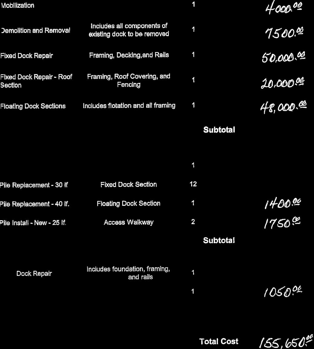
6 Table of Contents Requested Conditional Use... 1 Existing Conditions... 1 Existing Zoning... 1 Proposed Development... 1 Staff Analysis 2 conditional use.2 Staff Recommedation 2 Planning and Appeals Commission Recommedation.. 2 Appendix A conditional use standards... A-1 Appendix B conditional use application... B-1 Appendix C correspondence from the public... C-1 Appendix D photograph... D-1

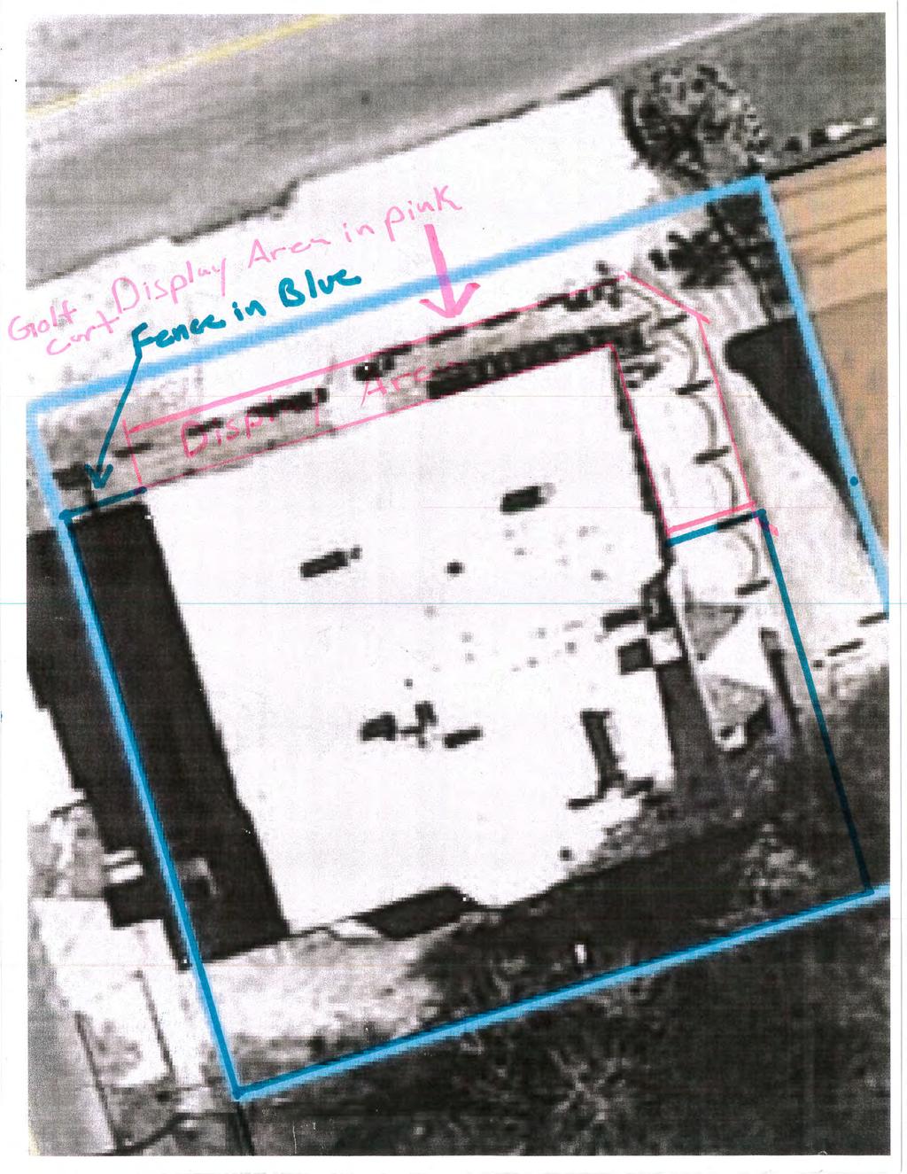
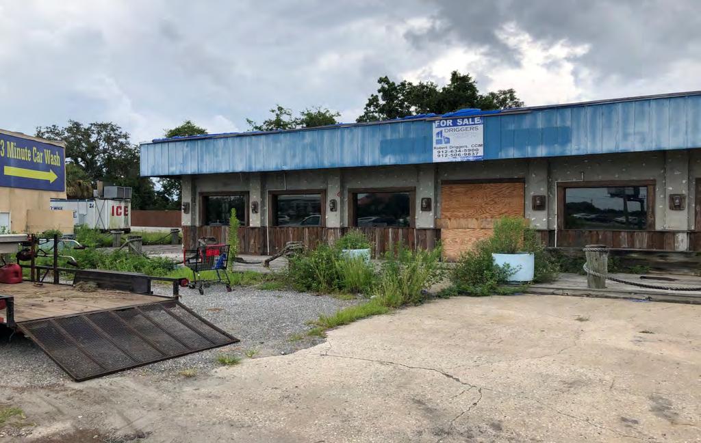
7 Requested Conditional Use Robert Timothy Klapp is petitioning to obtain a conditional use permit to allow a motorized vehicle sales and repair facility at 2027 Stacy Street. Existing Conditions The subject parcel is.26 acres ± in size with one building located on the subject parcel. The building was last used as a restaurant, but has been vacant for a few years. It includes limited parking on the east and north sides of the parcel. The subject parcel is shown outlined in blue on the following location map. Location Map 2027 Stacy St. Existing Zoning The subject parcel is zoned Highway Commercial (HC) as are all of the surrounding parcels. Proposed Development There is no proposed change to the size of the existing structure or parcel other then cosmetic improvements. The potential owner will be locating a golf cart sales and service business within the building. 1
8 Staff Analysis Conditional Use Section (b) of the zoning ordinance allows a garage for the repair and servicing of motor vehicles, provided that all operations are conducted within a fully enclosed building or buildings, and there is no open storage of wrecked vehicles, dismantled parts, or supplies visible beyond the premises. The conditional use process allows the City Commission to place conditions on a parcel to make certain that the proposed uses are compatible with surrounding uses. Staff recommends the following conditions: 1. The repair and storage of all golf carts must occur within the fully enclosed building and there will be no open storage of wrecked vehicles, dismantled parts, or any other materials visible beyond the premises. 2. Any display of golf carts on the property be limited to hours open for business and must be secured in the building during non-business hours. Staff would like to note that the above condition has been followed by the previous owners and the parcel does not have a history of code violations. Staff notes that the permit authorizing a conditional use will only be valid for that particular conditional use and will expire if the conditional use or operations pertaining thereto ceases for more than six continuous months for any reason. If the conditional use expires, the property can still be used for any of the permitted uses in the underlying HC (Highway Commercial) zone district. Staff Recommendation Staff recommends in favor of granting the requested conditional use with the following condition: 1. The repair and storage of all golf carts must occur within the fully enclosed building and there will be no open storage of wrecked vehicles, dismantled parts, or any other materials visible beyond the premises. 2. Any display of golf carts on the property be limited to hours open for business and must be secured in the building during non-business hours. Planning Commission Recommendation The Planning and Appeals Commission reviewed the application at their August 8, 2018 meeting and held a Public Hearing. The Planning and Appeals Commission voted 5-0 to recommend approving the request for a Conditional Use with the following conditions: 1. The repair and storage of all golf carts must occur within the fully enclosed building and there will be no open storage of wrecked vehicles, dismantled parts, or any other materials visible beyond the premises. 2. Any display of golf carts on the property be limited to hours open for business and must be secured in the building during non-business hours. 3. The approval be contingent upon the applicant closing on the purchase of the property. If the Applicant fails to close on the purchase the Conditional Use becomes null and void. 2
9 Appendix A conditional use standards ARTICLE XXVI. APPEALS, CONDITIONAL USES AND VARIANCES Sec Conditional Uses and Variances. (d) When acting upon applications for conditional uses the Commission shall determine that the granting of the conditional use will not adversely affect the public interest, health, safety, and general welfare; and that the following standards, where applicable, have been met: (1) the proposed use must be consistent with the intent, goals, and objectives and programs of the City of Brunswick Comprehensive Plan for the area in which the property is located; (2) the intensity of the proposed use must be consistent with the intended future use of the designated land use area in which the property is located, in accordance with the provisions of the Future Land Use Map ; (3) the effect of the proposed development on the present or intended character of the area in which it is proposed for location; (4) the proposed use, singularly or in combination with other previously approved conditional uses, must not be detrimental to the health, safety, welfare, morals, order, comfort, convenience, appearance or prosperity of the neighborhood or adjacent uses; (5) The intensity of the proposed use must be harmonious with the character of other uses in the neighborhood; (6) The height and orientation of any proposed structures(s) must be compatible with existing neighboring structures and uses; (7) The subject parcel must be adequate in shape and size to accommodate the proposed use, and provide for appropriate separation between neighboring uses; (8) The proposed use must be adequately screened and buffered to effectively separate traffic, light and noise from existing or intended nearby uses; (9) The loading and/or refuse areas must not impose negative visual, odor, or noise impacts on abutting uses or thoroughfares; A-1
10 (10) The size and location of proposed sign(s) must be compatible with the character of existing neighboring uses; (11) Exterior lighting must be harmonious with the character of existing neighboring uses, in terms of glare; (12) The ingress and egress to the subject parcel and any structure involved must not adversely affect traffic flow, safety or control; (13) The access and internal circulation must be adequate in case of fire or emergency; (14) The proposed use must not adversely affect traffic flow, safety or control on the surrounding roadway system; (15) The location, type and availability of proposed potable water systems must be adequate for the proposed use and must not adversely affect neighboring potable water systems; (16) The location, type and availability of proposed wastewater systems must be adequate for the proposed use and compatible with drainage conditions in the area and neighboring uses; and (17) The proposed use must not cause or intensify flooding of neighboring uses. A-2
11 Appendix B conditional use application B-1
12
13
14
15
16 Appendix C correspondence from the public (none) C-1

17 Appendix D photograph D-1
18
19
20
21
22
23
24
25
26
27
28
29
30
31
32
33
34

35

36
37
38
39 Return to: Hall Booth Smith, P.C. Attn: Charles A. Dorminy, J.D., LL.M Darien Highway, Suite 300 Brunswick GA STATE OF GEORGIA COUNTY OF GLYNN A CONVEYANCE, Deed, Transfer, and Grant of Easement Rights made and entered into this day of, 2018, by and between CITY OF BRUNSWICK, a municipal corporation of the State of Georgia, acting by and through its Mayor and Board of Commissioners (hereinafter referred to as the "Grantor"), and the BRUNSWICK-GLYNN COUNTY JOINT WATER AND SEWER COMMISSION, a public corporation created by Local Act of the General Assembly of the State of Georgia, acting by and through its Board of Commissioners (hereinafter referred to as the "Grantee"). Page 1 of 8
40 WITNESSETH: WHEREAS, Grantor and Grantee (along with Glynn County) entered into an Operational Agreement on July 6, 2007, and six Addenda thereto as of the date hereof (collectively the "Operational Agreement"), for the purposes of entrusting the Grantee herein with the operation and maintenance of a unified water and wastewater system (hereinafter "System"), and transferring to Grantee all of its right, title and interest in Grantor's real, personal and intangible property, and assets and projects for the operation and maintenance of the System; and WHEREAS, the Operational Agreement further provides that any of the aforesaid property and/or assets discovered to be owned by Grantor will be conveyed to the Grantee for use in the operation and maintenance of the System. NOW THEREFORE, Grantor herein, for and in consideration of the mutual promises and undertakings as hereinafter contained and other good and valuable consideration paid to it at and before the sealing and delivery of these presents, the receipt whereof is hereby acknowledged and confessed, does hereby grant, convey, transfer, assign and deliver unto the Grantee, its successors and assigns in full fee simple title and/or an easement (where applicable), the following described real and/or personal property, easements, rights in land used in the operation, maintenance and expansion of the System. As used herein, the term "property" may include, but not be limited to, water and sanitary sewer systems, plants, works, instrumentalities and properties used in connection with the System and in the conservation, treatment, filtration, sedimentation and disposal of sanitary sewerage, and the distribution and sale of water for public and private uses. Said property and assets are set forth in Exhibit "A" attached hereto and made a part hereof. Page 2 of 8
41 There is expressly excluded from this transfer and conveyance to Grantee herein any and all land and properties and rights in property pertaining to drainage, utilities other than water and sanitary sewer, storm water facilities and street rights-of-way. Notwithstanding, Grantor does hereby grant and convey unto said Grantee, its successors and assigns, the right at all times to reconstruct, install, relocate, maintain, repair, replace water and sewer systems located within Grantor's street rights-of-way. This transfer and conveyance shall convey title to real property, so far as real property and easements and rights therein are concerned, shall convey title with respect to all tangible and intangible personal property appurtenant thereto, and shall be subject to all rights contained in referenced instruments. TO HAVE AND TO HOLD the above described real and/or personal property and easements, together with all and singular rights, members and appurtenances thereof, thereto and therein, to the same being, belonging, or in any wise appertaining, to the only proper use, and benefit of Grantee, successors and assigns, forever in full fee simple title, so that neither the Grantor nor any person or persons claiming under it shall at any time, by any means or ways, dispute the right, title and interest of the Grantee. Grantor herein represents and covenants that its Board of Commissioners approved and authorized the making and execution of this conveyance and transfer and Grantor has furnished to Grantee herein certified copies of that portion of the minutes of meetings of its Board of Commissioners approving and authorizing the conveyance and transfer and that such meeting was held in accordance with the applicable laws of the State of Georgia. Page 3 of 8
42 IN WITNESS WHEREOF, Grantor has caused this instrument of conveyance, deed, transfer and grant to be signed in its name and its seal to be affixed thereto and attested by its Clerk, all in accordance and compliance with the laws of the State of Georgia, and delivered these presents on this the day and year first above written. CITY OF BRUNSWICK, GEORGIA By: Attest to: CORNELL HARVEY, Mayor NAOMI ATKINSON, Clerk Unofficial Witness Signed, sealed and delivered on this day of, 2018, and in the presence of: NOTARY PUBLIC My Commission Expires: Page 4 of 8
43 EXHIBIT A All of the following tracts, lots and parcels of land, lying and being in Glynn County, Georgia, pertaining to water and wastewater systems, excepting any drainage provisions therein, excepting any rights-of-way but including access provisions therein to water and sewer lines, appurtenances and facilities, and being more particularly described as follows, to-wit: Parcel 1 Lift Station All that tract or parcel of land, containing 35,736 square feet, lying and being in G.M.D. 26, City of Brunswick, Glynn County, Georgia, and being more particularly described as follows: The Point of Beginning is a point on the southwestern right of way of Stonewall Street (50-foot wide public right of way, which point is South 17 degrees 55 minutes 56 seconds East feet from a 1/2 capped iron rebar set at the intersection of the southwestern right of way of said Stonewall Street with the southeastern right of way of 5th Street (60-foot wide public right of way), and from said Point of Beginning run thence along the right of way of said Stonewall Street South 17 degrees 55 minutes 56 seconds East feet to a 1/2 capped iron rebar set at the northeastern corner of Lot 134 of Lawrenceville Subdivision; run thence along the northwestern line of said Lot 134 South 72 degrees 04 minutes 04 seconds West feet to a 1/2" capped iron rebar set; run thence along the southwestern line of said Lot 134 South 17 degrees 55 minutes 56 seconds East feet to a point; run thence South 72 degrees 04 minutes 04 seconds West 7.50 feet to a point; run thence South 17 degrees 55 minutes 56 seconds East feet to a nail set; run thence South 72 degrees 04 minutes 04 seconds West feet to a 1/2" capped iron rebar set; run thence North 13 degrees 04 minutes 28 seconds West feet to a 1/2" capped iron rebar set; run thence North 12 degrees 22 minutes 31 seconds West feet to a 1/2" capped iron rebar set; run thence North 11 degrees 26 minutes 51 seconds West feet to a 1/2" capped iron rebar set; run thence North 10 degrees 27 minutes 01 seconds West feet to a 1/2" capped iron rebar set on the right of way of 5th Street (60-foot wide public right of way) run thence North 72 degrees 04 minutes 04 seconds East feet to a point; run thence along a curve at the southwest corner of the intersection of said Stonewall Street and said 5th Street a chord length of feet (an arc length of feet) a chord bearing of South 62 degrees 55 minutes 56 seconds East to a point on the southwestern right of way of Stonewall Street, which point is the Point of Beginning of the herein described tract. Said description according to Boundary Survey of Lift Station #WWL 4005, a Portion of Carver Heights (F/K/A Lawrenceville), by Gary R. Nevill, Georgia Registered Land Surveyor No dated December 20, 2016, and recorded in the public records of Glynn County, Georgia, in Plat Book, Page, to which reference is hereby particularly made. Page 5 of 8
44 Parcel 2 Lift Station All that tract or parcel of land, containing 2,627 square feet, lying and being in G.M.D. 26, City of Brunswick, Glynn County, Georgia, and being more particularly described as follows: In order to find the Point of Beginning, commence at the southeast corner of Lot 11 of Oak Park Subdivision, which corner is located at the intersection of the western right of way of Norman Street (80-foot wide public right of way) with the northern right of way of Kaufman Street (50- foot wide public right of way), and from said corner run thence along the western right of way of said Norman Street and along the eastern boundary of Lot 11 and then Lot 10 of said Oak Park Subdivision a distance of feet, more or less, to a 3/4" iron pin found which marks the Point of Beginning of the herein described tract. From said Point of Beginning run thence along the northern boundary of Lot 10 Oak Park Subdivision North 82 degrees 00 minutes 00 seconds West feet to a 1/2" capped iron rebar set; run thence North 39 degrees 52 minutes 00 seconds East 6.55 feet to a 1/2" capped iron rebar set; run thence North 25 degrees 44 minutes 00 seconds East 9.50 feet to a 1/2" capped iron pin found; run thence North 14 degrees 58 minutes 00 seconds East 9.90 feet to a 1/2" capped iron pin found; run thence North 08 degrees 19 minutes 52 seconds feet to a 1/2" capped iron rebar set; run thence North 05 degrees 14 minutes 38 seconds East 5.27 feet to a 1/2" capped iron rebar set; run thence South 82 degrees 00 minutes 00 seconds East feet to a 3/4" iron pin found disturbed at the southeast corner of Lot 9 of Oak Park Subdivision, which is on the western right of way of said Norman Street; run thence along the western right of way of said Norman Street South 08 degrees 48 minutes 41 seconds West feet to the Point of Beginning of the herein described tract. Said description according to Boundary Survey of Lift Station #WWL4016, Oak Park Subdivision, by Gary R. Nevill, Georgia Registered Land Surveyor No dated November 3, 2017, and recorded in the public records of Glynn County, Georgia, in Plat Book, Page, to which reference is hereby particularly made. Parcel 3 Lift Station All that tract or parcel of land, containing 900 square feet, lying and being in G.M.D. 26, City of Brunswick, Glynn County, Georgia, and being more particularly described as follows: Begin at a ½ capped iron rebar set at the southwestern corner of the hereinafter described property, said beginning point has Georgia State Coordinate System, East Zone, NAD83 of N and E , run thence North 03 degrees 47 minutes 24 seconds West feet to a ½ capped iron rebar set; run thence North 86 degrees 12 minutes 36 seconds East feet to a ½ capped iron rebar set (N and E ); run thence South 03 degrees 47 minutes 24 seconds East feet to a ½ capped iron rebar set; run thence South 86 degrees 12 minutes 36 seconds West feet to the point of beginning. Page 6 of 8
45 Said description according to Easement Survey of Lift Station #WWL4019 by Gary R. Nevill, Georgia Registered Land Surveyor No dated June 20, 2016, and recorded in the public records of Glynn County, Georgia, in Plat Book, Page, to which reference is hereby particularly made. Parcel 4 Lift Station All that tract or parcel of land, containing 193 square feet, lying and being in G.M.D. 26, City of Brunswick, Glynn County, Georgia, and being more particularly described as follows: Begin at a nail set on the northeastern margin of the right-of-way of Glynn Avenue (a/k/a U.S. Highway 17) (200± feet wide right-of-way), said beginning point has Georgia State Coordinate System, East Zone, NAD83 of N and E , run thence North 75 degrees 23 minutes 03 seconds East feet to a nail set; run thence South 14 degrees 26 minutes 00 seconds East feet to a nail set (N and E ); run thence South 75 degrees 44 minutes 56 seconds West feet to a nail set on the northeastern margin of the right-of-way of said Glynn Avenue; run thence along a curve in the northeastern margin of the right-of-way of said Glynn Avenue North 14 degrees 26 minutes 00 seconds West a chord length (an arc length of feet) to the point of beginning. Said description according to Boundary Survey of Lift Station #WWL4031 by Gary R. Nevill, Georgia Registered Land Surveyor No dated May 19, 2016, and recorded in the public records of Glynn County, Georgia, in Plat Book, Page, to which reference is hereby particularly made. Parcel 5 Elevated Water Storage Tank All that tract or parcel of land, containing 8,100 square feet, lying and being in G.M.D. 26, City of Brunswick, Glynn County, Georgia, and being more particularly described as follows: Begin at a 1/2 capped iron rebar set at the intersection of the western right of way of Martin Luther King, Jr. Boulevard (120-foot wide public right of way) with the northern right of way of Prince Street (90-foot wide public right of way), which said 1/2 capped iron rebar set is the southeastern-most corner of Lot 541, Old Town, and the Point of Beginning of the herein described tract. From said Point of Beginning run thence along the northern right of way of said Prince Street South 72 degrees 39 minutes 00 seconds West feet to a 1/2 capped iron rebar set; run thence North 17 degrees 21 minutes 00 seconds West feet to a 1/2 capped iron rebar set; run thence North 72 degrees 39 minutes 00 seconds East feet to a 1/2 capped iron rebar set on the western right of way of said Martin Luther King, Jr. Boulevard; run thence along the western right of way of said Martin Luther King, Jr. Boulevard South 17 degrees 21 minutes 00 seconds East feet to the 1/2 capped iron rebar set which marks the Point of Beginning of the herein described tract. Page 7 of 8
46 Said description according to Boundary Survey of Elevated Water Storage Tank #11EST, a Portion of Lot 541, Old Town, by Gary R. Nevill, Georgia Registered Land Surveyor No dated July 15, 2016, and recorded in the public records of Glynn County, Georgia, in Plat Book, Page, to which reference is hereby particularly made. Parcel 6 Water Treatment Facility All that tract or parcel of land, containing 15,622 square feet, lying and being in G.M.D. 26, City of Brunswick, Glynn County, Georgia, and being more particularly described as follows: In order to find the Point of Beginning of the herein described tract, commence at a ½ iron rebar found at the intersection of the northern margin of the right-of-way of Wildwood Drive (50-foot wide right-of-way) with the eastern margin of the right-of-way of Shrine Road (50-foot wide right-of-way) and run thence along the eastern margin of the right-of-way of said Shrine Road North 12 degrees 22 minutes 26 seconds East feet to a ½ iron rebar found, continue thence along the eastern margin of the right-of-way of said Shrine Road North 09 degrees 38 minutes 07 seconds East feet to a ½ iron rebar found, leaving the said right-of-way run thence South 78 degrees 13 minutes 49 seconds West feet to a capped iron rebar found, which capped iron rebar found marks the Point of Beginning of the herein described tract. From the Point of Beginning run thence South 07 degrees 01 minutes 34 seconds East feet to a ¾ iron rebar found; run thence South 78 degrees 08 minutes 01 seconds West feet to a ½ iron rebar found; run thence North 17 degrees 22 minutes 54 seconds West feet to a punch hole set; run thence North 78 degrees 13 minutes 49 seconds East feet to the Point of Beginning of the herein described tract. Said description according to Boundary Survey of Water Treatment Facility #103WT/GSF, Day Tract, by Gary R. Nevill, Georgia Registered Land Surveyor No dated May 20, 2016, and recorded in the public records of Glynn County, Georgia, in Plat Book, Page, to which reference is hereby particularly made. Page 8 of 8
47 Y:\Project Files\16028\DWG\16028.dwg, 10/30/ :37:35 AM
48 Y:\Project Files\16045\DWG\16045.dwg, 11/8/ :00:43 AM
49 Y:\Project Files\16026\DWG\16026.dwg, 6/23/2016 4:18:37 PM
50 Y:\Project Files\16115\DWG\16115.dwg, 6/21/2016 4:23:28 PM
51 Y:\Project Files\16218\DWG\16218.dwg, 10/30/ :51:55 AM
52 Y:\Project Files\16076\DWG\ dwg, 5/31/2016 1:10:16 PM
53
54
55
56
57
58
59
60
61
62
63

64
65
66
67
68
69
70
71
72
73
74
75
76
77
78
79
80
81
82
83
84
85
86
87
88
MEMORANDUM. Mayor and City Council. Warren Hutmacher, City Manager. Date: February 11, 2013
 MEMORANDUM To: From: Mayor and City Council Warren Hutmacher, City Manager Date: February 11, 2013 Subject: Approval of an Intergovernmental agreement by and between the City of Dunwoody and DeKalb County
BILL NO (Emergency Measure) ORDINANCE NO. 5072
 ORDINANCE NO. 5072") BILL NO. 5210 (Emergency Measure) ORDINANCE NO. 5072 AN ORDINANCE AUTHORIZING THE MAYOR TO EXECUTE WITH MICHELSON-HADLEY HEIGHTS DEVELOPMENT, LLC, A CONTRACT AND QUIT CLAIM DEED CONVEYING CERTAIN PROPERTIES
BILL NO. 5210 (Emergency Measure) ORDINANCE NO. 5072 AN ORDINANCE AUTHORIZING THE MAYOR TO EXECUTE WITH MICHELSON-HADLEY HEIGHTS DEVELOPMENT, LLC, A CONTRACT AND QUIT CLAIM DEED CONVEYING CERTAIN PROPERTIES
COUNCIL AGENDA MEMO ITEM NO. III - #1
 COUNCIL AGENDA MEMO ITEM NO. III - #1 FROM: Anton Jelinek, Director of Utilities MEETING: October 24, 2017 SUBJECT: PRESENTER: Permanent Utility and Right-of-Way Easement Anton Jelinek Discussion: At the
COMMUNITY DEVELOPMENT DEPARTMENT. To: Board of Commissioners VIA: Finance Committee. From: David Hainley, Director. Re:
 COMMUNITY DEVELOPMENT DEPARTMENT 1725 Reynolds Street, Suite 200, Brunswick, GA 31520 To: Board of Commissioners VIA: Finance Committee From: David Hainley, Director Re: Accepting 0.744 acres of land and
ORDINANCE NO.:
 ORDINANCE NO.: 2013-098 Authorizing the City Manager to execute a Limited Warranty Deed conveying the improvements (an approximate 300 space parking garage) known as the Bell South Parking Garage constructed
Utility Easement from Suncoast Community Health Centers Inc Release of Easement
 0 YLANi AGENDA REPORT 5T FLORID DATE 10 24 11 TO FROM SUBJECT City Commission Gregory Horwedel City Manager Utility Easement from Suncoast Community Health Centers Inc Release of Easement RECOMMENDATION
PERMANENT DRAINAGE EASEMENT
 City Project No. Project Name: ; Tr. # Parcel No. (LLC, Corporation, Partnership) PERMANENT DRAINAGE EASEMENT THIS AGREEMENT, made and entered into this day of, 201, by and between, a, hereinafter called
Sketch & Legal Description of Mitigation Bank and Ingress/Egress Access Easements
 Appendix H: Sketch & Legal Description of Mitigation Bank and Ingress/Egress Access Easements Tippen Bay Wetland Mitigation Bank DeSoto County, Florida Prepared by: September, 2017 Original file
AMENDMENT TO POWER PURCHASE AGREEMENT
 AMENDMENT TO POWER PURCHASE AGREEMENT This Amendment Power Purchase and Agreement ( Amendment ) is entered into as of, 2012, by and between, (hereinafter RMW ) a Nevada limited liability company, and The
DECLARATION OF RECIPROCAL ACCESS AND UTILITY EASEMENTS
 ITEM 175-2701-C0517 Page 1 of 6 Return to: Grant Road LLC 1430 Country Manor Boulevard, Suite 3 Billings, MT 59102 DECLARATION OF RECIPROCAL ACCESS AND UTILITY EASEMENTS This Reciprocal Easement Declaration
WASHINGTON STATE COUNTY AUDITOR/RECORDER'S INDEXING FORM
 AFTER RECORDING RETURN TO: The City of Gig Harbor Attn: City Clerk 3510 Grandview St. Gig Harbor, WA 98335 WASHINGTON STATE COUNTY AUDITOR/RECORDER'S INDEXING FORM Document Title(s) (or transactions contained
CHAPTER 2 RELATED DOCUMENTS AND FORMS
 CHAPTER 2 RELATED DOCUMENTS AND FORMS TABLE OF CONTENTS CHAPTER 2 RELATED DOCUMENTS AND FORMS Resolution R00- Establishing Public Improvement Design Standards Page 1 Current Plans Review & Construction
MECKLENBURG COUNTY Land Use & Environmental Services Agency Groundwater & Wastewater Services
 MECKLENBURG COUNTY Land Use & Environmental Services Agency Groundwater & Wastewater Services Instructions for Permitting On-Site Sewage Treatment & Disposal Systems Requiring a Septic System Easement,
EXHIBIT "B", Page 1 of 5 This Instrument Was Prepared By: Record and Return To: Lynn Bodor I Land Records City of Boca Raton 201 Palmetto Park Road Bo
 EXHIBIT "B", Page 1 of 5 This Instrument Was Prepared By: Record and Return To: Lynn Bodor I Land Records City of Boca Raton 201 Palmetto Park Road Boca Raton, Florida 33432 (Reserved) EASEMENT DEED THIS
BOARD OF COUNTY COMMISSIONERS AGENDA ITEM SUMMARY
 4E1 BOARD OF COUNTY COMMISSIONERS AGENDA ITEM SUMMARY PLACEMENT: CONSENT PRESET: TITLE: EXECUTION AND ADOPTION OF A UTILITY EASEMENT AGREEMENT BY AND BETWEEN MARTIN COUNTY AND OBP WEST, LLC AND TO ADOPT
WATER LINE & INGRESS/EGRESS EASEMENT AGREEMENT WITNESSETH:
 Prepared by and return to: Carie E. Shealy, MMC, City Clerk City of Cocoa 65 Stone Street Cocoa, Florida 32922 Parcel ID. #(s): WATER LINE & INGRESS/EGRESS EASEMENT AGREEMENT THIS EASEMENT AGREEMENT is
EASEMENT AGREEMENT. WHEREAS, Ferguson is the 100% owner of the property described on Exhibit B attached hereto (the Williams Property );
;") EASEMENT AGREEMENT THIS EASEMENT AGREEMENT ( Agreement ) is entered into as of this day of, 2016, by and between CRAIG FERGUSON ( Ferguson ), and MAMIE DAVIS and JERRY MOORE ( Davis & Moore ), whose legal
EASEMENT AGREEMENT THIS EASEMENT AGREEMENT ( Agreement ) is entered into as of this day of, 2016, by and between CRAIG FERGUSON ( Ferguson ), and MAMIE DAVIS and JERRY MOORE ( Davis & Moore ), whose legal
STANDARDIZED LEGAL DESCRIPTIONS AND EXHIBITS
 STANDARDIZED LEGAL DESCRIPTIONS AND EXHIBITS Public Works Department, Engineering Division June 14, 2004 UNIFIED GOVERNMENT STANDARDIZED LEGAL DESCRIPTIONS AND EXHIBITS For: Roads, Bridges, Short Span
PERPETUAL DRAINAGE EASEMENT
 PERPETUAL DRAINAGE EASEMENT THIS GRANT OF PERPETUAL DRAINAGE EASEMENT is made this day of, 2016, between [name and address] ("Grantor"), and the City of Thornton, a Colorado municipal corporation, located
APPENDIX G: SAMPLE CROSS-ACCESS AGREEMENTS
 APPENDIX G: SAMPLE CROSS-ACCESS AGREEMENTS THIS AGREEMENT is made and entered into on this (date) by (owner's name), a corporation authorized to transact business in the State of Ohio ("OWNER") and the
WHEREAS, it is the desire and intent of the party of the first part to convey unto
 THIS DEED OF SUBDIVISION, DEED OF CONVEYANCE and DEED OF EASEMENT, made this 24th day of August, 1984, by and between LAKEPOINTE DEVELOPMENT CORPORATION, a Virginia corporation, party of the first part;
CITY AND COUNTY OF BROOMFIELD SUBDIVISION IMPROVEMENT AGREEMENT FOR (PROPERTY NAME - ALL CAPS)
") CITY AND COUNTY OF BROOMFIELD SUBDIVISION IMPROVEMENT AGREEMENT FOR (PROPERTY NAME - ALL CAPS) THIS AGREEMENT, made and entered into this day of, 20, by and between The CITY AND COUNTY OF BROOMFIELD, a
CITY AND COUNTY OF BROOMFIELD SUBDIVISION IMPROVEMENT AGREEMENT FOR (PROPERTY NAME - ALL CAPS) THIS AGREEMENT, made and entered into this day of, 20, by and between The CITY AND COUNTY OF BROOMFIELD, a
GENERAL WARRANTY DEED
 PROJECT. # 89008160 TRACT NO.:10 PARCEL ID NO.:PL199032200000001003 OWNERS NAME: Park Hill School District SITUS ADDRESS:5520 N. Northwood: KANSAS CITY, MISSOURI MAILING ADDRESS:7703 NW Barry Rd. Kansas
AGENDA ITEM FORM INFORMATION ONLY PRESENTATION DISCUSSION ONLY ACTION ITEM
 Town of Dumfries Council Meeting AGENDA ITEM FORM Meeting Date: Agenda Item# February 5, 2019 XIII-A TYPE OF AGENDA ITEM: PURPOSE OF ITEM: CONSENT AGENDA INFORMATION ONLY PRESENTATION DISCUSSION ONLY ACTION
RESOLUTION NO
 Page 1 of 7 1 4 5 6 7 8 9 10 11 1 1 14 15 16 17 18 19 0 1 4 RESOLUTION NO. 018- A RESOLUTION OF THE BOARD OF COUNTY COMMISSIONERS OF BROWARD COUNTY, FLORIDA, APPROVING AND AUTHORIZING THE CONVEYANCE OF
RIGHT OF WAY AND COMMON DRIVEWAY AGREEMENT SUN8 PDC, LLC, c/o DISTRIBUTED SUN, LLC SUBDIVISION DRYDEN, NEW YORK
 RIGHT OF WAY AND COMMON DRIVEWAY AGREEMENT SUN8 PDC, LLC, c/o DISTRIBUTED SUN, LLC SUBDIVISION DRYDEN, NEW YORK THIS RIGHT OF WAY AGREEMENT ( Agreement ) is made this day of, 2017 by SCOTT PINNEY, an individual
AGREEMENT FOR TEMPORARY CONSTRUCTION EASEMENT AND PERMANENT SEWER UTILITY EASEMENT
 AGREEMENT FOR TEMPORARY CONSTRUCTION EASEMENT AND PERMANENT SEWER UTILITY EASEMENT This Agreement for Temporary Construction Easement and Permanent Sewer Utility Easement (hereinafter the "Agreement")
SIDEWALK ACCESS EASEMENT AGREEMENT
 SIDEWALK ACCESS EASEMENT AGREEMENT THIS SIDEWALK ACCESS EASEMENT AGREEMENT ( Agreement ) is made by and among WATERWALK PLACE OWNERS ASSOCIATION, a Kansas non-profit corporation ( WWP ), FOUR-G, LLC, a
DECLARATION OF COVENANTS, CONDITIONS AND RESTRICTIONS HICKORY NUT OF WILDEWOOD ASSOCIATION, INC.
 DECLARATION OF COVENANTS, CONDITIONS AND RESTRICTIONS OF HICKORY NUT OF WILDEWOOD ASSOCIATION, INC. THIS DECLARATION, made and entered into this 17 th day of February, 1987 by PARAGON BUILDERS, INC., a
CORPORATE SPECIAL WARRANTY DEED FOR RIGHT OF WAY
 CORPORATE SPECIAL WARRANTY DEED FOR RIGHT OF WAY THIS INDENTURE WITNESSETH that ELI LILLY AND COMPANY, an Indiana corporation, ( Grantor ), as a gift and for no other consideration, CONVEYS ANDSPECIALLY
THE GENERAL ASSEMBLY OF PENNSYLVANIA SENATE BILL AN ACT
 PRINTER'S NO. THE GENERAL ASSEMBLY OF PENNSYLVANIA SENATE BILL No. INTRODUCED BY VANCE, APRIL, 00 REFERRED TO STATE GOVERNMENT, APRIL, 00 Session of 00 AN ACT 0 0 Authorizing the Department of General
DEED OF EASEMENT Utility Line and Grinder Pump
 RECORD AND RETURN TO: Jerry Jackson City of LaPorte, Wastewater Department 2101 Boyd Blvd, LaPorte IN 46350 DEED OF EASEMENT Utility Line and Grinder Pump THIS DEED OF EASEMENT, made this day of,, by (insert
COUNCIL ACTION FORM Meeting Date: September 13, 2012 Staff Contact: John Sullivan, Public Works Director
 COUNCIL ACTION FORM Meeting Date: September 13, 2012 Staff Contact: John Sullivan, Public Works Director Agenda Item: Consider vacation of a Landscape Easement granted to the City of Westwood for the construction
APPLICATION TO REGISTER NOTICE OF AN AGREEMENT THE LAND TITLES ACT SECTION 74
 26 th May 1981 Campeau - City of Kanata 40% Open Space Agreement APPLICATION TO REGISTER NOTICE OF AN AGREEMENT THE LAND TITLES ACT SECTION 74 TO: THE LAND REGISTRAR FOR THE LAND TITLES DIVISION OF OTTAWA-CARLETON
APPENDIX C STANDARD FORMS OF LEGAL AGREEMENT
 APPENDIX C STANDARD FORMS OF LEGAL AGREEMENT TABLE OF CONTENTS PAGE # Certificate of Authenticity...C-4 Deed of Dedication, Subdivision and Easement...C-5 Deed of Easement...C-11 Deed of Dedication...C-14
ORDINANCE NO
 DRAFT NO. 16-52 ORDINANCE NO. 2016 48 AN ORDINANCE AUTHORIZING THE CITY MANAGER, OR HIS DESIGNEE, TO ENTER INTO AN AGREEMENT BETWEEN THE CITY OF KENT AND GARY PHILLIP BERARDINELLI TO SELL 0.2833 ACRES
PROPERTY EXCHANGE & CONVEYANCE AGREEMENT RECITALS
 PROPERTY EXCHANGE & CONVEYANCE AGREEMENT This Property Exchange and Conveyance Agreement ( Agreement ) is entered into as of the date of execution by and between Laramie Church of Christ, Inc., a Wyoming
Dated October 14, 1966 As to Acknowledged October 14, 1966 University Hills No. 2 Subdivision Reported October 18, 1966 Liber 1954, Page 28
 Orchard Lane Land Company Declaration of Restrictions Dated October 14, 1966 As to Acknowledged October 14, 1966 University Hills No. 2 Subdivision Reported October 18, 1966 Liber 1954, Page 28 This Declaration,
MARTIN COUNTY BOARD OF COUNTY COMMISSIONERS
 MARTIN COUNTY BOARD OF COUNTY COMMISSIONERS DOUG SMITH Commissioner, District 1 UTILITIES & SOLID WASTE DEPARTMENT PO Box 9000 Stuart, FL 34995-9000 John E. Polley Director Phone (772) 221-1442 Fax (772)
TOWN OF BOONSBORO DEPARTMENT OF PLANNING, ZONING & ENGINEERING
 TOWN OF BOONSBORO DEPARTMENT OF PLANNING, ZONING & ENGINEERING WWW.TOWN.BOONSBORO.MD.US 301-432-5690 PLAN CHANGE: SYCAMORE RUN RETAINING WALL, DRAINAGE, AND GRADING ALTERATIONS STAFF REPORT May 17, 2018
DEED AND DEDICATION FOR PUBLIC RIGHT OF WAY
 TO : BOARD OF DIRECTORS FROM : GARY PLATT, EXEC. DIRECTOR BUSINESS AND OPERATIONS SUBJECT : CITY OF STANWOOD CONSTRUCTION EASEMENT AND RIGHT-OF-WAY DEDICATION DATE : MARCH 17, 2009 TYPE : ACTION NEEDED
BOARD OF COUNTY COMMISSIONERS AGENDA ITEM SUMMARY
 6B BOARD OF COUNTY COMMISSIONERS AGENDA ITEM SUMMARY PLACEMENT: PUBLIC HEARINGS PRESET: TITLE: REQUEST FOR THE ABANDONMENT OF A PORTION OF THE PLATTED NE ST. LUCIE BOULEVARD RIGHT-OF-WAY LYING WITHIN THE
WATERFORD LANDING COMMUNITY DEVELOPMENT DISTRICT REGULAR MEETING AGENDA
 WATERFORD LANDING COMMUNITY DEVELOPMENT DISTRICT REGULAR MEETING AGENDA January 31, 2019 Waterford Landing Community Development District OFFICE OF THE DISTRICT MANAGER 2300 Glades Road, Suite 410W Boca
(Space above this line reserved for Recorder of Deeds)
") (Space above this line reserved for Recorder of Deeds) STORMWATER MANAGEMENT and BEST MANAGEMENT PRACTICES FACILITIES MAINTENANCE AGREEMENT COVER PAGE Date: Grantor: Grantee: Property Owner Owner's Address
(Space above this line reserved for Recorder of Deeds) STORMWATER MANAGEMENT and BEST MANAGEMENT PRACTICES FACILITIES MAINTENANCE AGREEMENT COVER PAGE Date: Grantor: Grantee: Property Owner Owner's Address
INVITATION FOR SALE BY SEALED BID: RE-BID. BID NO Nottingham Drive, Brunswick, Georgia
 INVITATION FOR SALE BY SEALED BID: RE-BID BID NO. 03-02927 105 Nottingham Drive, Brunswick, Georgia TO THE BRUNSWICK-GLYNN COUNTY JOINT WATER AND SEWER COMMISSION Issued Monday June 19, 2017 Submission
SAMPLE DECLARATION OF VACATION OF EASEMENT/RIGHT OF WAY. of record in the Office of the Judge of Probate of Morgan County, Alabama in Plat
 SAMPLE DECLARATION OF VACATION OF EASEMENT/RIGHT OF WAY ) KNOW ALL MEN BY THESE PRESENTS, THAT: OWNER S NAME, owner of all of the property adjacent to that certain drainage, utilities, and telecommunications
MARTIN COUNTY BOARD OF COUNTY COMMISSIONERS
 MARTIN COUNTY BOARD OF COUNTY COMMISSIONERS DOUG SMITH Commissioner, District 1 UTILITIES & SOLID WASTE DEPARTMENT PO Box 9000 Stuart, FL 34995-9000 John E. Polley Director Phone (772) 221-1442 Fax (772)
PROTECTIVE COVENANTS DEED RESTRICTIONS SPENCER BUSINESS/INDUSTRIAL PARK August 11, 1999 Amended, March 3, 2014
 PROTECTIVE COVENANTS DEED RESTRICTIONS SPENCER BUSINESS/INDUSTRIAL PARK August 11, 1999 Amended, March 3, 2014 1. GENERAL PURPOSES and CONDITIONS The real property conveyed hereby, being part of the Spencer
WAKE COUNTY STORMWATER CONTROL STRUCTURE AND ACCESS EASEMENT AND AGREEMENT (Corporate)
") Return to: Matthew Flynn Stormwater Field Services Administrator Water Resources Department Town of Cary PO Box 8005, Cary, NC 27512 NORTH CAROLINA WAKE COUNTY STORMWATER CONTROL STRUCTURE AND ACCESS EASEMENT
Return to: Matthew Flynn Stormwater Field Services Administrator Water Resources Department Town of Cary PO Box 8005, Cary, NC 27512 NORTH CAROLINA WAKE COUNTY STORMWATER CONTROL STRUCTURE AND ACCESS EASEMENT
NON-EXCLUSIVE ROADWAY AND UTILITY EASEMENT DEED AND AGREEMENT
 RETURN TO: STOGSDILL LAW OFFICE, P.C. 505 West Main, Suite 313 Lewistown, Montana 59457 (406) 538-2623 NON-EXCLUSIVE ROADWAY AND UTILITY EASEMENT DEED AND AGREEMENT THIS EASEMENT DEED AND AGREEMENT is
BRUNSWICK-GLYNN COUNTY JOINT WATER AND SEWER COMMISSION
 BRUNSWICK-GLYNN COUNTY JOINT WATER AND SEWER COMMISSION PROCEDURE FOR ABANDONMENT OF EXISTING WATER AND SEWER UTILITY EASEMENTS 1703 Gloucester Street Brunswick, GA 31520 http://www.bgjwsc.org I. PURPOSE
50-Foot Non-Exclusive EASEMENT AGREEMENT
 50-Foot Non-Exclusive EASEMENT AGREEMENT THIS EASEMENT AGREEMENT is dated this day of _, 20, by Parker Task Force For Human Services (hereafter referred to as "Grantor"), having an address at 20118 East
STATE OF GEORGIA, Athens-Clarke County
 Warranty Deed STATE OF GEORGIA, Athens-Clarke County This INDENTURE made and entered into this 19th day of August, in the year of our Lord One Thousand Nine Hundred and Ninety Eight (1998) between MARION
SOUTH DAKOTA BOARD OF REGENTS. Budget and Finance ******************************************************************************
 SOUTH DAKOTA BOARD OF REGENTS Budget and Finance AGENDA ITEM: 6 K DATE: October 2-4, 2018 ****************************************************************************** SUBJECT USD Discovery District:
AGREEMENT RECITALS: Draft 3/26/2015
 AGREEMENT This Agreement is entered into this day of April, 2015, by and between the SCHOOL BOARD OF BREVARD COUNTY, FLORIDA (the "School Board") and THE CITY OF MELBOURNE, a Florida municipal corporation
DEED OF EASEMENTS PREPARED BY, AND WHEN RECORDED RETURN TO:
 Addendum-12-14-13-C1-4736 Lee Highway Easements - Page 1 PREPARED BY, AND WHEN RECORDED RETURN TO: Real Estate Bureau Chief Department of Environmental Services Arlington County Government 2100 Clarendon
Recitals. WHEREAS, Grantor owns real property ("Property"), under which Improvements (as defined in Section 1 below) will pass; and
, under which Improvements (as defined in Section 1 below) will pass; and") EASEMENT AGREEMENT This Easement Agreement ("Agreement") effective this 24 th day of April, 2017, by and between YMCA Community Campus, LLC, whose address is 3200 Spaulding Avenue, Pueblo, CO 81008 ( Grantor
EASEMENT AGREEMENT This Easement Agreement ("Agreement") effective this 24 th day of April, 2017, by and between YMCA Community Campus, LLC, whose address is 3200 Spaulding Avenue, Pueblo, CO 81008 ( Grantor
TEMPORARY ACCESS/UTILITY EASEMENT AGREEMENT
 Prepared by: RETURN: R. Brian Shutt, Esq. City Attorney's Office 200 N.W. 1st Avenue Delray Beach, Florida 33444 TEMPORARY ACCESS/UTILITY EASEMENT AGREEMENT THIS TEMPORARY ACCESS/UTILITY EASEMENT AGREEMENT
OPTION TO PURCHASE REAL ESTATE AGREEMENT BETWEEN CITY OF WICHITA, KANSAS AND DSW BROADVIEW, LLC
 OPTION TO PURCHASE REAL ESTATE AGREEMENT BETWEEN CITY OF WICHITA, KANSAS AND DSW BROADVIEW, LLC OPTION TO PURCHASE REAL ESTATE AGREEMENT THIS OPTION TO PURCHASE REAL ESTATE AGREEMENT ( Option Agreement
CITY OF TEXARKANA, ARKANSAS STREET AND DRAINAGE EASEMENT
 CITY OF TEXARKANA, ARKANSAS STREET AND DRAINAGE EASEMENT STATE OF ARKANSAS COUNTY OF MILLER FOR and in consideration of the sum often dollars ($10.00) in hand paid by the City of Texarkana, Arkansas, the
EXHIBIT C TVA TRACT NO. XTBRDC-1, LOT REDBUD SUBDIVISION SPECIAL WARRANTY DEED
 EXHIBIT C THIS DEED WOULD BE USED FOR LAND OWNED BY TVA AND WHERE THE LOTS ARE NOT ON THE WATERFRONT. A STATEMENT OF SUBDIVISION STANDARDS AND SHORELINE MANAGEMENT ZONE (SAMPLES ATTACHED HERETO AS EXHIBITS
To achieve the conservation purposes, the following conditions and restrictions are set forth:
 DEED OF CONSERVATION EASEMENT (Conservation Subdivision District) STATE OF GEORGIA COUNTY OF COBB THIS DEED OF CONSERVATION EASEMENT (herein "Conservation Easement") is made this day of, 20, by and between
ORDINANCE NO
 Draft No. 12-21 ORDINANCE NO. 2012-23 AN ORDINANCE ACCEPTING A RIGHT-OF-WAY AND UTILITY EASEMENT FOR WATER LINES, SEWER LINES, STORM SEWER LINES AND SUCH OTHER UTILITIES AS ARE NEEDED FROM THE CARTER JONES
It is necessary for the Board to adopt the attached resolution accepting the dedication of the easement.
 SOUTHAMPTON COUNTY BOARD OF SUPERVISORS Regular Session i May 28, 2013 11. ACCEPTANCE OF A SANITARY SEWER EASEMENT FROM THE COMMONWEALTH OF VIRGINIA, DEPARTMENT OF TRANSPORTATION Attached for your review
BILL OF SALE. All of the water lines, writer mains anrl appurtenances locaterl on Exhibit "A"
 BILL OF SALE KNOW ALL MEN BY THESE PRESENTS, That on this-day of,2008, that School Board of Brevard County a Florida Corporation, hereinafter called "Sellers", and in consideration of the sum of One Dollar
EASEMENT DEED. 2) Thence N 60º12 36 W through said Parcel 1 a distance of Two Hundred Ninety- Five and 97/100 (295.97) feet to a point;
 Thence N 60º12 36 W through said Parcel 1 a distance of Two Hundred Ninety- Five and 97/100 (295.97) feet to a point;") EASEMENT DEED TALL TREES CONSTRUCTION CORP., a Maine corporation having a mailing address of 30 Preservation Drive, Falmouth, Maine 04105 (the "Grantor") for consideration paid, grants to the TOWN OF FALMOUTH,
EASEMENT DEED TALL TREES CONSTRUCTION CORP., a Maine corporation having a mailing address of 30 Preservation Drive, Falmouth, Maine 04105 (the "Grantor") for consideration paid, grants to the TOWN OF FALMOUTH,
BOARD OF COUNTY COMMISSIONERS AGENDA ITEM SUMMARY PLACEMENT: CONSENT PRESET: TITLE: ACCEPTANCE OF A DRAINAGE EASEMENT FROM CASA PISCES, LLC (CASA)
") 4C1 BOARD OF COUNTY COMMISSIONERS AGENDA ITEM SUMMARY PLACEMENT: CONNT PRET: TITLE: ACCEPTANCE OF A DRAINAGE EAMENT FROM CASA PISCES, LLC (CASA) AGENDA ITEM DATES: MEETING DATE: 4/25/2017 COMPLETED DATE:
4C1 BOARD OF COUNTY COMMISSIONERS AGENDA ITEM SUMMARY PLACEMENT: CONNT PRET: TITLE: ACCEPTANCE OF A DRAINAGE EAMENT FROM CASA PISCES, LLC (CASA) AGENDA ITEM DATES: MEETING DATE: 4/25/2017 COMPLETED DATE:
COMMUNITY DEVELOPMENT DEPARTMENT. Phone: Fax:
 COMMUNITY DEVELOPMENT DEPARTMENT.1. 72.5 Reynolds Street, Second Floor, Brunswick, GA 31520 MEMO A Golden Past. A Shining Future. TO: FROM: Subject: Board of Commissioners David Hainley, Community Development
PARKLANDS LEE COMMUNITY DEVELOPMENT DISTRICT SPECIAL MEETING AGENDA
 PARKLANDS LEE COMMUNITY DEVELOPMENT DISTRICT SPECIAL MEETING AGENDA February 9, 2017 Parklands Lee Community Development District OFFICE OF THE DISTRICT MANAGER 2300 Glades Road, Suite 410W Boca Raton,
The Drainage Encroachment Agreement has been revised as of August 2014.
 Vanderburgh County Surveyor s office Linda Freeman Jeff Mueller, PE, County Surveyor Doug McDonald, PE, LS Chief Deputy Special Deputy The Drainage Encroachment Agreement has been revised as of August
DEED OF EASEMENT STATE OF NEW JERSEY AGRICULTURE RETENTION AND DEVELOPMENT PROGRAM. BETWEEN, whose address is and is referred to as the Grantor;
 Page 1 of 8 E3-E DEED OF EASEMENT STATE OF NEW JERSEY AGRICULTURE RETENTION AND DEVELOPMENT PROGRAM This Deed is made, 20. BETWEEN, whose address is and is referred to as the Grantor; AND, whose address
SPECIAL WARRANTY DEED
 Consideration: $1,500,000.00 Doc Stamps: $!0,500.00 Prepared by and after recording return to: DONNA J, FELDMAN, P,A, Jessica Paz Mahoney, Esq. 19321-C U.S, Highway 19 North Suite 600 Clearwater, Florida
Tax Map Key Nos. (1) : 003, :004 and :008 CPR No. Total Pages: Unit No.
 : 003, :004 and :008 CPR No. Total Pages: Unit No.") LAND COURT SYSTEM AFTER RECORDATION: RETURN BY MAIL ( ) PICK UP ( ) REGULAR SYSTEM Tax Map Key Nos. (1) 2-3-016: 003, :004 and :008 CPR No. Total Pages: Unit No. LIMITED WARRANTY UNIT DEED, ENCUMBRANCES
LAND COURT SYSTEM AFTER RECORDATION: RETURN BY MAIL ( ) PICK UP ( ) REGULAR SYSTEM Tax Map Key Nos. (1) 2-3-016: 003, :004 and :008 CPR No. Total Pages: Unit No. LIMITED WARRANTY UNIT DEED, ENCUMBRANCES
MEMORANDUM OF AGREEMENT FOR PROPOSED SPECIAL WARRANTY DEED
 MEMORANDUM OF AGREEMENT FOR PROPOSED SPECIAL WARRANTY DEED Date: December 11, 2013 Grantee: The City of Bryan (City) Grantor: Doris Johnson Jones Address: 5351 Creely Avenue Richmond, CA 94804 Parcel No.:
TITLE 145: DEPARTMENT OF PUBLIC LANDS SUBCHAPTER AGRICULTURAL HOMESTEAD WAIVER PROGRAM RULES AND REGULATIONS
 SUBCHAPTER 145-20.1 AGRICULTURAL HOMESTEAD WAIVER PROGRAM RULES AND REGULATIONS Part 001 - General Provisions 145-20.1-001 Authority 145-20.1-005 Purpose Part 100 - Agricultural Homestead Waiver Program
COUNCIL COMMUNICATION
 Meeting Date: June 27, 2017 COUNCIL COMMUNICATION Agenda Item: Agenda Location: Consent Calendar Work Plan # Legal Review: 1 st Reading 2 nd Reading Subject: A resolution approving the grant of a perpetual
CITY MANAGER MEMORANDUM
 CITY MANAGER MEMORANDUM To: The Honorable Mayor Kelley and City Commissioners Through: Joyce A. Shanahan, City Manager From: Ric Goss, AICP, Planning Director Date: July 14, 2011 Subject: 17 Foxfords Chase,
DECLARATION OF ELEVATED PEDESTRIAN WALKWAY EASEMENT
 AFTER RECORDING MAIL TO: Drury Southwest Broadview, LLC 101 S. Farrar Drive Cape Girardeau, Missouri 63701 Attn: Herbert J. Wedemeier (Space left blank for recording purposes) DECLARATION OF ELEVATED PEDESTRIAN
Resolution approving the transfer of Tract G (Public Pump Station Parcel) within the Alterra Subdivision.
 within the Alterra Subdivision.") AGENDA REPORT DATE: January 9, 2017 TO: FROM: SUBJECT: City Commission Mike Herr, City Manager Resolution approving the transfer of Tract G (Public Pump Station Parcel) within the Alterra Subdivision.
AGENDA REPORT DATE: January 9, 2017 TO: FROM: SUBJECT: City Commission Mike Herr, City Manager Resolution approving the transfer of Tract G (Public Pump Station Parcel) within the Alterra Subdivision.
CITY OF INDIANAPOLIS GRANT OF PERPETUAL DRAINAGE EASEMENT AND RIGHT-OF-WAY
 CROSS REFERENCE TO DEED#: PROJECT #: DRN - INSTRUMENT NO.: PARCEL #: CITY OF INDIANAPOLIS GRANT OF PERPETUAL DRAINAGE EASEMENT AND RIGHT-OF-WAY THIS INDENTURE made this day of, 20, by and between, ("GRANTOR")
Thomas E. Barzee, Jr., City Counselor
 N6RTH KANSAS CITY Virtually Urbon. Supremely Suburban. 2010 Howell NORTH KANSAS CITY, MO 64116 TEL: ( 816) 274-6000 FAX: ( 816) 421-5046 www.nkc.org MEMORANDUM To: FROM: RE: Mayor and City Council Thomas
RESOLUTION OF INDIAN LAKE BOROUGH. *, 1997 the Borough Council. WHEREAS, Bernie Wires submitted a proposed plan for an elevated sand mound on
 RESOLUTION 1997-2 OF INDIAN LAKE BOROUGH AND NOW, this 1 3 t h day of m *, 1997 the Borough Council of Indian Lake Borough hereby resolves as follows: WHEREAS, Bernie Wires submitted a proposed plan for
COUNCIL COMMUNICATION
 Meeting Date: September 27, 2016 COUNCIL COMMUNICATION Agenda Item: Agenda Location: Consent Calendar Work Plan # Legal Review: 1 st Reading 2 nd Reading Subject: A resolution granting a ditch easement
GeoPoint 1403 E. 5th Avenue Tampa, Florida
 AIRPORT ROAD PINELAND P.R.D. SUBDIVISION - PHASE 1 DEDICATION: CERTIFICATE OF REVIEW BY SURVEYOR, CITY OF ORMOND BEACH DEDICATION: THIS IS TO CERTIFY THAT FORESTAR (USA) REAL ESTATE GROUP INC., A DELAWARE
Cross Reference: Instrument No. A State Parcel No Parcel: TEMPORARY CONSTRUCTION EASEMENT AGREEMENT
 Cross Reference: Instrument No. A199500066899 Project: 92TU000128 State Parcel No. 49-07-18-107-004.000-801 Parcel: 8033304 Date: Version: TEMPORARY CONSTRUCTION EASEMENT AGREEMENT THIS TEMPORARY CONSTRUCTION
CONVEYANCE - COMMONWEALTH PROPERTY IN THE BOROUGH OF EAST STROUDSBURG, MONROE COUNTY Act of Jul. 1, 2016, P.L., No. 65 Cl.
 CONVEYANCE - COMMONWEALTH PROPERTY IN THE BOROUGH OF EAST STROUDSBURG, MONROE COUNTY Act of Jul. 1, 2016, P.L., No. 65 Cl. 85 An Act Authorizing the Department of General Services, with the approval of
SOUTH DAKOTA BOARD OF REGENTS. Budget and Finance ******************************************************************************
 SOUTH DAKOTA BOARD OF REGENTS Budget and Finance AGENDA ITEM: 7 U DATE: October 4-6 ****************************************************************************** SUBJECT: SDSU 6 th Street Land Sale for
MEETING TYPE: Board of Commissioners - Regular. MEETING DATE: 23 May STAFF RESPONSIBLE: Matt Hubert. DEPARTMENT: Development Services Department
 MEETING TYPE: Board of Commissioners - Regular MEETING DATE: 23 May 2017 STAFF RESPONSIBLE: Matt Hubert DEPARTMENT: Development Services Department DESCRIPTION Approval of Easement Agreement To approve
to St. Louis County by deed recorded in Book 7954, Page 235 in the St. Louis County, Missouri
 Recommendation of Planning Commission BILL NO. 4032 ORDINANCE NO. 2015-3971 AN ORDINANCE ENACTING A CONDITIONAL USE PERMIT FOR AN ELECTRICAL SUBSTATION AT 11520 DORSETT ROAD Petition of Ameren Missouri)
RECITALS. Page 1 of 9
 INTERLOCAL AGREEMENT BETWEEN THE COUNTY OF VOLUSIA AND THE CITY OF DEBARY FOR REIMBURSEMENT OF UTILITY CONSTRUCTION AND A UTILITY SERVICE AGREEMENT FOR POTABLE WATER THIS AGREEMENT is entered into by and
RESOLUTION R EAST COUNTY MIDDLE SCHOOL SCHOOL SITE PLAN SSP DTS
 RESOLUTION R-18-003 EAST COUNTY MIDDLE SCHOOL SCHOOL SITE PLAN SSP-17-02 DTS20170502 A RESOLUTION OF THE BOARD OF COUNTY COMMISSIONERS OF MANATEE COUNTY, FLORIDA, REGARDING LAND DEVELOPMENT; ALLOWING FOR
NOTICE OF ADOPTION OF
 NOTICE OF ADOPTION OF REVISED PROTECTIVE COVENANTS OF OLD NAGS HEAD COVE ASSOCIATION WHEREAS, the developer of Old Nags Head Cove Subdivision had caused to be recorded a certain Declaration of Restrictions
Environmental and Engineering Services EASEMENT INFORMATION AND EXAMPLE DOCUMENTS
 Environmental and Engineering Services Reddy Chitepu, P.E., Director EASEMENT INFORMATION AND EXAMPLE DOCUMENTS Please refer to the information below when compiling easement documents for submittal to
FIDELITY NATIONAL TITLE INSURANCE COMPANY COMMITMENT FOR TITLE INSURANCE SCHEDULE A
 File No. PRO-16-2562W 1. Effective Date: FIDELITY NATIONAL TITLE INSURANCE COMPANY COMMITMENT FOR TITLE INSURANCE SCHEDULE A REVISION B 2. Policy or policies to be issued: Amount (a) ALTA Owner s Policy:
DEED OF EASEMENT & MAINTENANCE AGREEMENT FOR STORMWATER MANAGEMENT FACILITIES THIS DEED OF EASEMENT AND MAINTENANCE AGREEMENT FOR
 (The City of Chesapeake is exempt from recordation taxes pursuant to Section 58.1-811.A.3. and Grantors are exempt pursuant to Section 58.1-811.C.5. of the 1950 Code of Virginia as amended.) DEED OF EASEMENT
ORDINANCE NO
 DRAFT NO. 16-53 ORDINANCE NO. 2016-49 AN ORDINANCE ACCEPTING FOR DEDICATION PURPOSES FROM GARY PHILLIP BERARDINELLI A STORM SEWER EASEMENT, AND DECLARING AN EMERGENCY. WHEREAS, Gary Phillip Berardinelli
ORDINANCE NO. CID-3087
 ORDINANCE NO. CID-3087 AN ORDINANCE MAKING FINDINGS AS TO THE NATURE AND ADVISABILITY OF CREATING A COMMUNITY IMPROVEMENT DISTRICT AT THE NORTHEAST CORNER OF 91 ST STREET AND METCALF AVENUE; CREATING SAID
DEED OF EASEMENT (RECLAIMED WATER,WATER AND SEWER) [AND DEED OF VACATION (RECLAIMED WATER, WATER AND SEWER)]
![DEED OF EASEMENT (RECLAIMED WATER,WATER AND SEWER) [AND DEED OF VACATION (RECLAIMED WATER, WATER AND SEWER)]](/thumbs/72/66569549.jpg "DEED OF EASEMENT (RECLAIMED WATER,WATER AND SEWER) [AND DEED OF VACATION (RECLAIMED WATER, WATER AND SEWER)]") Project Name: Loudoun Water Project Number: DEED OF EASEMENT (RECLAIMED WATER,WATER AND SEWER) [AND DEED OF VACATION (RECLAIMED WATER, WATER AND SEWER)] THIS DEED OF EASEMENT [AND VACATION] is made and
Project Name: Loudoun Water Project Number: DEED OF EASEMENT (RECLAIMED WATER,WATER AND SEWER) [AND DEED OF VACATION (RECLAIMED WATER, WATER AND SEWER)] THIS DEED OF EASEMENT [AND VACATION] is made and
Appendix A - REQUIRED PLAT CERTIFICATES... A-1
 APPENDICES CONTENTS: Appendix A - REQUIRED PLAT CERTIFICATES... A-1 Appendix B - MINIMUM STREET IMPROVEMENT STANDARDS Standard 1A Minor Residential... B-1 Standard 1B Minor Residential... B-2 Standard
UTILITY EASEMENT AGREEMENT
 THIS INSTRUMENT PREPARED BY AND RETURN TO: Roy K. Payne, Esq. Chief Assistant City Attorney 400 S. Orange Avenue Orlando, FL 32801 Roy.Payne@CityofOrlando.Net UTILITY EASEMENT AGREEMENT THIS UTILITY EASEMENT