Land Cadastre in Slovenia From History into the Future
|
|
|
- Buddy O’Brien’
- 5 years ago
- Views:
Transcription
1 Land Cadastre in Slovenia From History into the Future Tomaž Petek Surveying and Mapping Authority of the Republic of Slovenia Vienna, May 2017

2 Content of the presentation Introduction Overview of the history of land cadastre Development of land surveying in general in Slovenia. About the Franciscean Cadastre in Slovenia Developments through the 19 th and 20 th century Current organizational, legal and technical status of state surveying service in Slovenia Conclussions and planned future developments


3 Home of inhabitants Area of km2 Hous numbers: Settlements: 6031 Wooded area: 66% Land parcels: Buildings: 1, mio Coastline: 46 km


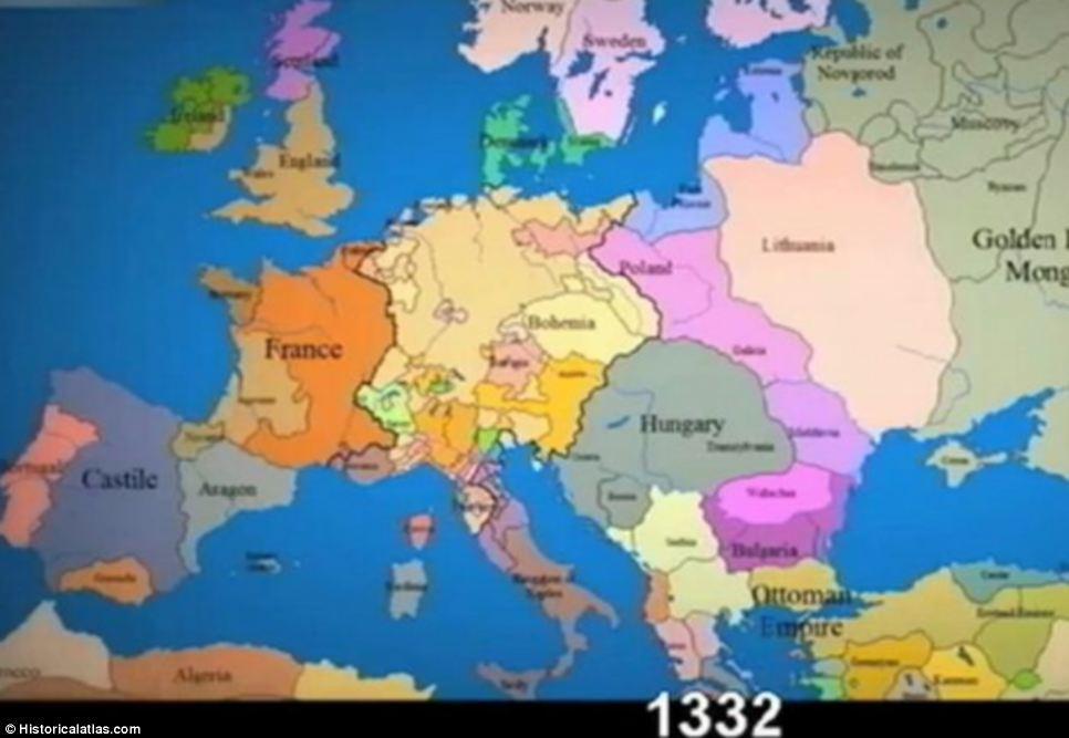


4 Time-lapse changing borders in Europe over the past 1,000 years


5 Modern period or the modern era 1852
6 REAL ESTATE REGISTRATION DEVELOPEMEND Urbarium Real estate book (Gultbuch) Theresian cadastre Josephine cadastre French cadaster Francisceian cadastre Gaus Kruger CRS Register of Spatal units From paper to digital GNSS stations SIGNAL Building Cadastre New ETRS CRS Utility cadastre Mass Valuation Modernisation and interoperability 1516, 1536, 1634, , 1756, 1784,..1817, 1828, 1867, 1896, 1947, 1991,
 Urbarium (ger.")
7 Example of Urbarium from belopeški urbarj from year 1498 for seatelment Jesenice (Arhiv Republike Slovenije) Urbarium (ger. Urbar)
8 Imenska knjiga za Kranjsko (Ger. Gultbuch / Stadtbuch) century taxation of ovnersheep (Gült), Real estate ownersheep book (taxation cadastre), Renewed in Ljubljana bishoop ownersheep in period


, (ger.")
 Franciscean Cadastre")
9 Land cadastre development in the second half of 18th century Theresian cadastre ( ), (Patent, ) Josephine Cadastre ( ), (ger. Josefinische Steuerregulierung ) Franciscean Cadastre ( ), (Land Tax Patent )

 borders of vilages and")
10 Teresian Cadastre Example of form E from Teresian cadastre for dominikal real estate Postojna (Germ. Adelsberg), (Arhiv Republike Slovenije). Censuss of population ( ) borders of vilages and seatelments cadastral community

11 Josephine Cadastre, New cadastral operat announced with patent (ger. Josefinische Steuerregulierung ) Example of document from Josepine cadastre ( ), ovners from cadastral community Verdreng (Arhiv Republike Slovenije). Censuss of real estate 1789
.")
12 French cadastre Some smaller parts at the western border of the Republic of Slovenia with Italy were measured in French local coordinate systems in times of Napoleon during the period of Illyrian Provinces of the French Empire ( ). Metric cadatrsal maps in scale 1:2000, 1:4000 and 1:8000 (produced in period ) After 1817 was produced Franciscei cadaster for entire region.
 by the emperor Franz 23. 12. 1817.")
13 Franciscean Cadastre Franciscean Cadastre announced 1806 introduction of Land Tax Act (Germ. Grundsteuerpatent) by the emperor Franz (Source: Österreichische Nationalbibliothek)
 Kranjska (Germ. Krain) Koroška (Germ. Kärnthen) Štajerska (Germ. Steyermark) Prekmurje (Germ.")

14 Timescale of Franciscean Cadastre production for the specific lands Land Primorje z Istro (Germ. Küstenland) Kranjska (Germ. Krain) Koroška (Germ. Kärnthen) Štajerska (Germ. Steyermark) Prekmurje (Germ. Eisenburger und Szalader Comitat) Years of production Coordinate System Origin Krim, south of Ljubljana, Slovenia Schöcklberg, north of Graz, Austria Gellért, in Budapest, Hungary


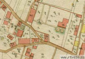

15 Franciscean Cadastre for Kranjsko (Germ. Krain) and Koroško (Germ. Kärnthen)
 1823-1869 Cadastral map for")
 from year 1823 and cadastral community")
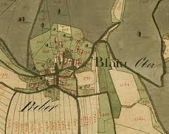
16 Franciscean Cadastre for Štajersko (Germ Steiermark) Cadastral map for Cadastral community Celje (Germ. Zilli) from year 1823 and cadastral community Cmurek, (Arhiv Republike Slovenije).


17 Primorska (Kustenlandes), Primorska land (Germ. Österreichisches Küstenland, Ital. Litorale Austriaco) divided on trigonometric sections in Krim coordinate system (Trieste Archive).


18 Franciscean Cadastre for Primorska z Istro (Germ. Küstenland),


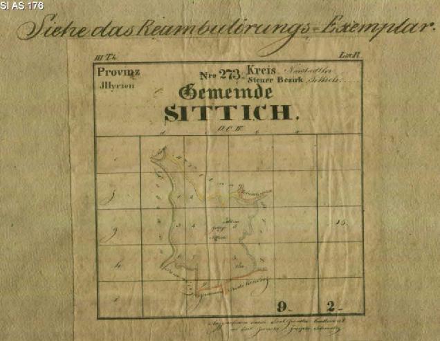
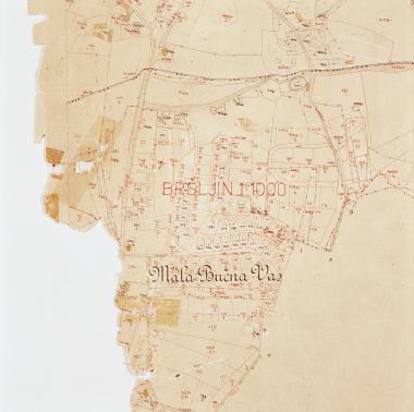
19 Sketches and description of border for cadastral municipality KOSTANJEVICA (Grem. Landesstrass) at Krain from 1824/1825 (Arhiv Republike Slovenije, Detailed measurement


20 Detailed measurement Part of cadastral map of Francisceis cadaster for KOSTANJEVICA on Krka (Germ. Landesstrass) from1825 and list of land parcels (Germ. Das Grundparzellenprotokoll).

21 Indication scetches Indication sketches for Cadastral comunity ŽAŽAR (Arhiv Republike Slovenije)


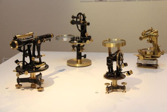
22 Preparation from 1806,..1810, Katastral-Vermessungs Instruktion, 1820


23 Origin of the Krim coordinate system shown on the map of Slovenia, with a clip of the viewing table with the metal cast trigonometric network of triangulation points of Franciscean cadastre. The viewing table was set up on a monument of the renovated origin triangulation point Krim in the year 1994.
 cadastral map, based on the new cadastral measurement in the year 1960, in the D48/GK Gauss-Krüger state")
24 Land cadastral mapping development through the 19 th and 20 th century Example of cadastral community Korovci with state border creek Kučnica between Austria and Slovenia: cadastral map, based on the first cadastral measurement in the year 1859, in the old Gellért coordinate system (left) cadastral map, based on the new cadastral measurement in the year 1960, in the D48/GK Gauss-Krüger state coordinate system (middle), cadastral map, based on the state border creek Kučnica regulation and land consolidation in the year 1992, coordinate cadastre in the D48/GK Gauss-Krüger state coordinate system (right).

 12 regional")

25 ORGANISATION Head office - (Ljubljana, Zemljemerska ulica 12) 12 regional geodetic administrations 42 branch survey offices.


26 Maintenance and updating real estate data sets: Land Cadastre Building Cadastre Real Estate Register State Border Register of Spatial Units and House Numbers


27 REAL ESTATE REGISTRATION DEVELOPEMEND 2001 from paper into computer 2011 from m2 to Euro


28 REAL ESTATE REGISTRATION DEVELOPEMEND 2006 building cadastre 2003 consolidated cadastre of pub lic infrastructure buildings parts of buildings 1,2 mio owners


29 REENGINEERING OF REAL ESTATE REGISTRATION DATASETS

30 IMPROVEMENT OF QUALITY FOR EXISTING DATASETS

31 DATA DISEMINATION, INSPIRE AND INTERNATIONAL ACTIVITIES


32 Exibition, book and 45. geodetic day From 1880
33 Conclusions From paper to digital From m2 to EURO From taxation to multipurpose From 2D to 3D From tradition to digital single market

34 QUESTIONS?
35 THANK YOU! DANKE! HVALA!
LAND CADASTRE Today and Challanges for the future Damjan DOLER
 LAND CADASTRE Today and Challanges for the future Damjan DOLER Head of Real Estate Department Regional surveying office Celje Mariborska cesta 88, Celje, SLOVENIA 32nd Conference of Surveyin Authorities,
The Multipurpose Hungarian Unified Land Registry System
 The Multipurpose Hungarian Unified Land Registry System András Osskó FIG Working Week Integrating Generation Stockholm, Sweden 14-19 June 2008 Republic of Hungary is located in Central Europe Neighbouring
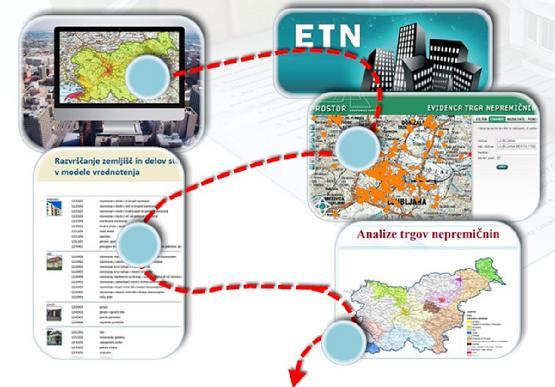
Consolidated Cadastre of Public Utility Infrastructure in Slovenia
 REPUBLIKA SLOVENIJA MINISTRSTVO A OKOLJE IN PROSTOR GEODETSKA UPRAVA REPUBLIKE SLOVENIJE Consolidated Cadastre of Public Utility Infrastructure in Slovenia Tomaž Petek agreb, 26.11.2015 Home of 2.010.000
Experiences with land consolidation and land banking in Slovenia since 1991
 Experiences with land consolidation and land banking in Slovenia since 1991 Anka LISEC University of Ljubljana Faculty of Civil and Geodetic Engineering anka.lisec@fgg.uni-lj.si University of Ljubljana
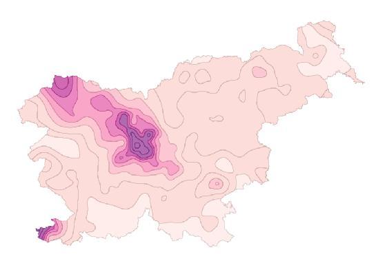
USE OF REAL ESTATE DATABASES FOR MASS VALUATION IN SLOVENIA
 GEODETSKA UPRAVA REPUBLIKE SLOVENIJE MINISTRSTVO ZA INFRASTRUKTURO IN PROSTOR REPUBLIKA SLOVENIJA URAD ZA MNOŽIČNO VREDNOTENJE NEPREMIČNIN USE OF REAL ESTATE DATABASES FOR MASS VALUATION IN SLOVENIA UNECE
Surveying in Austria. Congress Maanmittauspäivät Seinäjoki, 20 th March 2014
 Surveying in Austria Congress Maanmittauspäivät Seinäjoki, 20 th March 2014 Topics Facts, figures Organisational issues of surveying Role of the BEV Products, services The Cadastre Surveying Education
Parcel Boundaries in the Czech Republic
 Parcel Boundaries in the Czech Republic CZECH REPUBLIC Jiri Rydval, Libor Tomandl Czech Office for Surveying, Mapping and Cadastre inhabitants - 10.3 million territory 78,865 km 2 2 Contents: 1. A parcel
Cadastral survey - the best way of cadastre modernization Nikola VUČIĆ & Damir ŠANTEK, Croatia
 Presented at the FIG Congress 2018, May 6-11, 2018 in Istanbul, Turkey Cadastral survey - the best way of cadastre modernization Nikola VUČIĆ & Damir ŠANTEK, Croatia LAND ADMINISTRATION IN CROATIA Two
Slovenian Experiences
 Slovenian Experiences An example from a transition country Milan Brajnik, B.Sc.Geod., Assistant Director milan.brajnik@geod-is.si Geodetic Institute of Slovenia 1000 Ljubljana, Jamova cesta 2 The Identity
Procedures for the legalization and registration of buildings and building units Challenges and Problems Building cadastre in Slovenia
 Procedures for the legalization and registration of buildings and building units Challenges and Problems Building cadastre in Slovenia Edvard Mivšek M.Sc. Geodetic institut of Slovenija Pristina, 19 April
International funding projects in Republic Geodetic Authority
 International funding projects in Republic Geodetic Authority Serbia: Republic Geodetic Authority Workshop Exploring Funding Instruments for NMCA 7-8 November 2012 Republic Geodetic Authority Republic
LAND CADASTRE AND BUILDING CADASTRE IN SLOVENIA: CURRENT SITUATION AND POTENTIAL OF 3D DATA
 3D Cadastres Organizational and Governmental Aspects LAND CADASTRE AND BUILDING CADASTRE IN SLOVENIA: CURRENT SITUATION AND POTENTIAL OF 3D DATA EMA POGORELČNIK AND MARINA KOROŠEC Surveying and Mapping
Property Transactions in the Digital Age. The Property Cadastre in the Context of Spatial. Dr. Jens Riecken, NRW Ministry of the Interior
 Property Transactions in the Digital Age The Property Cadastre in the Context of Spatial Data Infrastructure (SDI) Dr. Jens Riecken, NRW Ministry of the Interior Property Transactions in the Digital Age
Global Geospatial Information Management. Country Report of Slovenia
 Zemljemerska ulica 12, 1000 Ljubljana T: +386 1 478 48 00 F: +386 1 478 48 34 E: pisarna.gu@gov.si http://www.gu.gov.s Global Geospatial Information Management Country Report of Slovenia Submitted by:
Annual Meeting 2006 SLOVENIA, BLED RASAS GOFMANAS JAUNIUS GRIGAS RIMANTAS RAMANAUSKAS KESTUTIS TRECIOKAS
 Annual Meeting 2006 SLOVENIA, BLED LAND ADMINISTRATION IN LITHUANIA RASAS GOFMANAS JAUNIUS GRIGAS RIMANTAS RAMANAUSKAS KESTUTIS TRECIOKAS ADMINISTRATIVE STRUCTURE OF LITHUANIA HISTORY OF LAND ADMINISTRATION
Extending limits of space. Geodetski zavod Celje
 Extending limits of space Geodetski zavod Celje Let us introduce International company based in Slovenia with 55 years of experience providing consulting and technical assistance services to public sector
Land and Geographic Information, an Important Part of the Infrastructure in Sweden
 Land and Geographical Information Land and Geographic Information, an Important Part of the Infrastructure in Sweden Land and Geographic Information, an Important Part of the Infrastructure In Sweden Bo
Cadastral survey - the best way of cadastre modernization
 Cadastral survey - the best way of cadastre modernization Nikola VUČIĆ, Croatia, Damir ŠANTEK, Croatia Key words: new cadastral survey, land registry, cadastre SUMMARY Different procedures for cadastral
Bruna Horović-Vuković Split, 15 September 2011
 Bruna Horović-Vuković Split, 15 September 2011 Archive of Maps for Istria and Dalmatia 1834 Archive of Maps for Dalmatia was founded in Zadar 1924 the material moves to Split into the Archive of the Maps
New Cadastral Mapping in the Czech Republic
 New Cadastral Mapping in the Czech Republic Karel Štencel, Svatava Dokoupilová, Jan Kmínek Czech Office for Surveying, Mapping and Cadastre Basic Data about the Czech Republic Area: 78 866 km 2 Population:
Development of 3D Cadastre in Hungary
 Development of 3D Cadastre in Hungary András OSSKÓ Gyula IVÁN CLGE General Assembly 22 March 2013, Budapest, HUNGARY Content Introduction Problems in development of 3D cadastre and registration Hungarian
Quality Improvement of the Real Estate Cadastre in Serbia
 , Serbia Key words: quality improvement, real estate information, quality assurance, Serbia SUMMARY The concept of cadastral modernization in the Republic of Serbia was defined in 1992, and it is being
Land Administration In Public Private Partnerships
 Land Administration In Public Private Partnerships Workshop Customers - Co-operation - Services Vienna, 12-13 September 2002 Peter Creuzer Content Land Administration - Tasks History Spatial Data Infrastructure
The institutional framework of land consolidation comparative analysis between Slovenia and Norway
 University of Life Sciences, Ǻs University of Ljubljana Faculty of Civil and Geodetic Engineering The institutional framework of land consolidation comparative analysis between Slovenia and Norway Anka
Role of Republic Geodetic Authority in the Serbian geo-sector
 Role of Republic Geodetic Authority in the Serbian geo-sector Republic Geodetic Authority, Serbia www.rgz.gov.rs EuroGeographics General Assembly 2014 Moldova, Chisinau, 28 th 30 th September 2014 The
The (Legal) Reliability of the Cadastre from the Perspective of the Czech Republic. Mgr. Martina Hercegová Ing. Karel Štencel
 Reliability of the Cadastre from the Perspective of the Czech Republic. Mgr. Martina Hercegová Ing. Karel Štencel") The (Legal) Reliability of the Cadastre from the Perspective of the Czech Republic Mgr. Martina Hercegová Ing. Karel Štencel PCC - Conference Vienna 20. 21. 11. 2018 Basic information about the CR Area:
The (Legal) Reliability of the Cadastre from the Perspective of the Czech Republic Mgr. Martina Hercegová Ing. Karel Štencel PCC - Conference Vienna 20. 21. 11. 2018 Basic information about the CR Area:
Layer approach to ownership in 3D cadastre a subway case
 Dimitrios KITSAKIS National Technical University of Athens, Greece 6 th International FIG Workshop on 3D Cadastres 2-4 October 2018, Delft,The Netherlands Jesper PAASCH University of Gävle & Lantmäteriet,
Cadastre and Land Registration in Europe
 Annex A: Questionnaire 2007 for Information Resource Cadastre and Land Registration in Europe Introduction This questionnaire is based on the EuroGeographics vision document 'Cadastre and Land Registration
Building Fit for Purpose Land Administration Systems - World Bank Experience
 Building Fit for Purpose Land Administration Systems - World Bank Experience Gavin Adlington Lead Land Administration Specialist The World Bank Fit For Purpose The only way to establish a successful land
Iranian Cadastre System. Nasrollah Jahangard Iran s Deeds and Properties Registration Organization I.R. of Iran 14 th PCGIAP, KL, Malaysia 2008
 Iranian Cadastre System Nasrollah Jahangard Iran s Deeds and Properties Registration Organization I.R. of Iran 14 th PCGIAP, KL, Malaysia 2008 General Information Europe Middle East Asia Africa Middle
Challenges for the multi purpose cadastre
 Jens RIECKEN, Markus SEIFERT, Germany Key words: Multi purpose cadastre, 3d-cadastre, land use, SDI, solar cadastre SUMMARY Over the past 30 years, with the progress of information technologies the development
WHAT IS NEW IN CADASTRE OF CZECH REPUBLIC. Libor Tomandl FIG Annual Meeting 2005, Madison
 WHAT IS NEW IN CADASTRE OF CZECH REPUBLIC Libor Tomandl FIG Annual Meeting 2005, Madison 1 Milestones of CzechCadastre 1993 -Establishment ofthe Czech Republic, -cadastral reform, Czech Cadastre of Real
NATIONAL REPORT REPUBLIC OF MACEDONIA
 NATIONAL REPORT REPUBLIC OF MACEDONIA AGENCY FOR REAL ESTATE CADASTRE Department for Geodetic Works Sasho Dimeski, Brankica Stojanovska, Srechko Tasevski REVIEW OF AREC National Cadastral and Mapping Agency
FIG Congress 2010 Facing the Challenges Building the Capacity Sydney, Australia, April
 Setting up the infrastructure for improving the development of Cadastre in Greece Dr. Dimitris ROKOS, Dr. Konstantinos KYRIAZIS and Dr. Panos LOLONIS KTIMATOLOGIO S.A. (Hellenic Cadastre) Source: wikipedia
Spatial Data Infrastructure in Sweden
 Spatial Data Infrastructure in Sweden Hans-Erik WIBERG, Sweden Key words: ABSTRACT Sweden was one of the first countries to address Data Infrastructure matters and have during several decades developed
Building Integrated Land Information Systems and Development of NSDI
 Stig JÖNSSON, Sweden Key words: Land administration, land information systems, property formation, spatial data infrastructure, Inspire, institutional cooperation SUMMARY Lantmäteriet the Swedish agency
Digitising in the Archives of the Republic of Slovenia JURE VOLČJAK Digitising at the Archives of the Republic of Slovenia
 JURE VOLČJAK Digitising at the Archives of the Republic of Slovenia Paper at the 17 th EBNA Conference (European Board of National Archives), directors of national archives of the EU Member States and
DEVELOPMENT OF A STUDY OF IMPLEMENTATION OF THE CADASTRE OF BUILDINGS IN THE REPUBLIC OF CROATIA
 REPUBLIC OF CROATIA Ministry of Construction and Physical Planning State Geodetic Administration Gruška 20, 10000 ZAGREB, CROATIA Phone: +385-1-6165-404 Fax: +385-1-6165-484 Terms of Reference DEVELOPMENT
BULGARIAN CADASTRE A GUARANTEE FOR THE OWNERSHIP RIGHTS IN IMMOVABLE PROPERTIES
 4 TH INTERNATIONAL CONFERENCE RECENT PROBLEMS IN GEODESY AND RELATED FIELDS WITH INTERNATIONAL IMPORTANCE February 28 - March 2, 2007, Inter Expo Centre, Sofia, Bulgaria BULGARIAN CADASTRE A GUARANTEE
Croatian SDI: a Tool for Accelerated Development of the Geo-Conscious Society
 STATE GEODETIC ADMINISTRATION Croatian SDI: a Tool for Accelerated Development of the Geo-Conscious Society Prof.Dr.Sc. Željko Bačić, Mr.Sc. Ljerka Rašić FIG Working Week 2009 - Surveyors Key Role in Accelerated
Support to Implementation of Multipurpose Cadastral Information system in Vietnam
 Support to Implementation of Multipurpose Cadastral Information system in Vietnam Lennart JOHANSSON and Per SÖRBOM, Sweden Key words: Land Registration, Land Information, Land Administration, SWOT analyse,
Serbia Should Have Online Cadastre for Property Like Other Countries in the Region
 Serbia Should Have Online Cadastre for Property Like Other Countries in the Region Tamara Borovcanin USAID Business Enabling Project The online real estate registry allows citizens to quickly and easily
Building a European Spatial Data Infrastructure: The Role of EuroGeographics
 Building a European Spatial Data Infrastructure: The Role of EuroGeographics Richard Kirwan President of EuroGeographics 1st Congress on Cadastre in the EU 1 Presentation overview EuroGeographics - the
Aspect of preliminary activities in the function of supporting NSDI
 Sonja DIMOVA, Republic of Macedonia Key words: e-governance, geospatial data, NSDI, INSPIRE, metadata SUMMARY The successful establishment of the NSDI in the true sense of the word cannot be performed
Use of data in Ukraine for sustainable economic growth. Oleksandr Maliuk State Service of Ukraine for Geodesy, Cartography and Cadastre
 Use of data in Ukraine for sustainable economic growth Oleksandr Maliuk State Service of Ukraine for Geodesy, Cartography and Cadastre Kehl, 2017 Content of the presentation Ukraine & StateGeoCadastre:
THE REPUBLIC OF TURKEY MINISTRY OF PUBLIC WORKS GENERAL DIRECTORATE OF LAND REGISTRY AND CADASTRE (TKGM) UNECE WPLA WORKSHOP. October 2010.
 UNECE WPLA WORKSHOP. October 2010.") THE REPUBLIC OF TURKEY MINISTRY OF PUBLIC WORKS GENERAL DIRECTORATE OF LAND REGISTRY AND CADASTRE (TKGM) UNECE WPLA WORKSHOP " The role of spatial planning to improve security of tenure" October 2010 Antalya
THE REPUBLIC OF TURKEY MINISTRY OF PUBLIC WORKS GENERAL DIRECTORATE OF LAND REGISTRY AND CADASTRE (TKGM) UNECE WPLA WORKSHOP " The role of spatial planning to improve security of tenure" October 2010 Antalya
Presented at the FIG Working Week 2017, May 29 - June 2, 2017 in Helsinki, Finland
 Presented at the FIG Working Week 2017, May 29 - June 2, 2017 in Helsinki, Finland Land Administration Success Story; Eastern Europe and Central Asia Dr. Mika-Petteri Törhönen Lead Land Administration
Content and message. 3D registration of real property in Denmark. Content and message. Introduction. Cadastral register
 Content and message 3D of real property in Denmark Jantien Stoter Section GIS technology, Delft University of Technology (NL) Esben Munk Sørensen and Lars Bodum GeoInformation and MediaTechnologi, Aalborg
LAND ADMINISTRATION IN CANADA HISTORICAL WISDOM AND MODERN CHALLENGES IN QUEBEC LAND ADMINISTRATION: FROM PAPER CADASTRAL MAPS TO ON-LINE SERVICES
 HISTORICAL WISDOM AND MODERN CHALLENGES IN QUEBEC LAND ADMINISTRATION: FROM PAPER CADASTRAL MAPS TO ON-LINE SERVICES Francis ROY P rof e s s or D é p. Sciences g é omatiques FIG Working Week Sofia, Bulgaria
INSPIRE implementation as a link between egovernment and environmental purposes
 INSPIRE implementation as a link between egovernment and environmental purposes Jiří Poláček Czech Office for Surveying, Mapping and Cadastre (ČÚZK) Agenda Role of ČÚZK branch in the INSPIRE implementation.
Presented at the FIG Working Week 2016, May 2-6, 2016 in Christchurch, New Zealand
 Presented at the FIG Working Week 2016, May 2-6, 2016 in Christchurch, New Zealand The IMPULS Project Is a Project About Cooperation, Coordination, Transparency and Data Sharing A SDI project in the Western
New Developments in the Hellenic Cadastre
 New Developments in the Hellenic Cadastre Prof. M. Kavouras Vice-president Ktimatologio S.A. (Hellenic Cadastre) The Hellenic Cadastre Background The Hellenic National Cadastre Organizational and institutional
Slovenian State Projects in the Field of Real Estate Registration
 Božena LIPEJ, Slovenia Key words: real estate, land cadastre, land register, modernization. ABSTRACT The making of adequate real estate policies requires well-organized real estate records which are one
Transparent Valuation as a Planning Support for Just Land Management System (LMS)
") Hrvoje TOMIĆ, Siniša MASTELIĆ IVIĆ, Miodrag ROIĆ, Croatia Transparent Valuation as a Planning Support for Just Land Management System (LMS) Contents Introduction Land management Real estate valuation The
Hrvoje TOMIĆ, Siniša MASTELIĆ IVIĆ, Miodrag ROIĆ, Croatia Transparent Valuation as a Planning Support for Just Land Management System (LMS) Contents Introduction Land management Real estate valuation The
Exchange of Experiences and Knowledge in Land Administration and Cadastral Services between Sweden and Indonesia
 TS 10G Knowledge Sharing Exchange of Experiences and Knowledge in Land Administration and Cadastral Services between Sweden and Indonesia Endri Diyanto, Indonesia Karolina Larsson, Sweden IPSLA INSTITUTIONAL
Country Report SWITZERLAND
 armasuisse Federal Office of Topography, swisstopo Country Report SWITZERLAND Dr. Daniel Steudler Swiss Annual Meeting 2013, FIG-Commission 7 22 October 2013, Yaoundé, Cameroon Basic Dimensions SWITZERLAND
The Boundary and the Effects of Cadastral Surveying in Cyprus
 The Boundary and the Effects of Cadastral Surveying in Cyprus Aristi Louca, Margarita Fani Surveyor Engineers, Cyprus Association of Rural and Surveying Engineers The History of Cyprus goes back 11000
Results of Central European Land Knowledge Center (CELK) Activities
 Activities") Results of Central European Land Knowledge Center (CELK) Activities András OSSKÓ, Hungary Key words :CELK Center, Property Rights and Land Market Development, Networking, direct knowledge transfer SUMMARY
Results of Central European Land Knowledge Center (CELK) Activities András OSSKÓ, Hungary Key words :CELK Center, Property Rights and Land Market Development, Networking, direct knowledge transfer SUMMARY
Presented at the FIG Congress 2018, May 6-11, 2018 in Istanbul, Turkey
 Presented at the FIG Congress 2018, May 6-11, 2018 in Istanbul, Turkey 5 Bibliometric Analysis of Articles Presented Under Commission 7: A Case of the 25th Fig Congress in Malaysia in 2014 Zeynel Abidin
Creation Land Administration in Formal and Informal Environment. FIG Commission 7 Working Group 1
 Creation Land Administration in Formal and Informal Environment András OSSKÓ, Hungary Key words: land administration, informal land tenure, customary tenure, sustainable Development. SUMMARY FIG Commission
Directorate of Survey and Mapping NAMIBIA. Cadastral Information System. Vehupisa Kasuko Tjatindi Surveyor Directorate of Survey and Mapping NAMIBIA
 Vehupisa Kasuko Tjatindi Directorate of Survey and Mapping NAMIBIA Tel: +64 61 965000 Directorate of Survey and Mapping NAMIBIA Cadastral Information System Introduction Over the past few decades cadastral
Mass Valuation and Sales Price Register in the Republic of Serbia
 REPUBLIC OF SERBIA REPUBLIC GEODETIC AUTHORITY Mass Valuation and Sales Price Register in the Republic of Serbia Department for Mass Valuation Head of Department: Marija Raskovic procena@rgz.gov.rs Soest,
Regional Cadastral Study Reforms in the Region
 UNECE WORKING PARTY ON LAND ADMINISTRATION Workshop on the Influence of Land Administration on People and Business Cavtat, Croatia 2-3 October 2008 Regional Cadastral Study Reforms in the Region Miodrag
Cadastre, innovation and tradition in taxation and real estate market
 Cadastre, innovation and tradition in taxation and real estate market relations and interactions in managing information on properties and owners elopmen Piermassimo Pavese Central Directorate for Cadastre,
Land Administration in Jordan
 Land Administration in Jordan Problems and Challenges Eng. Director of Registration Services Department of Lands & Survey q General information q Historical Background q Properties Initiation q Problems
Topographic Signs Important Context of 3D Cadastre
 STATE GEODETIC ADMINISTRATION Gruška 20,10 000 Zagreb, Croatia Delft University of Technology Faculty of Architecture and the Built Environment Department OTB GIS Technology Section Topographic Signs Important
Real Estate Administration at the Vancouver Port Authority (VPA) Presentation by Ron McMillan - GIS/LIS Coordinator December 13, 2004
 Presentation by Ron McMillan - GIS/LIS Coordinator December 13, 2004") Real Estate Administration at the Vancouver Port Authority (VPA) Presentation by Ron McMillan - GIS/LIS Coordinator December 13, 2004 Introduction Overview of the Vancouver Port Authority (VPA) How CAD
Real Estate Administration at the Vancouver Port Authority (VPA) Presentation by Ron McMillan - GIS/LIS Coordinator December 13, 2004 Introduction Overview of the Vancouver Port Authority (VPA) How CAD
AN APPROACH FOR RE-ENGINEERING ORGANIZATIONAL STRUCTURE OF REAL ESTATE VALUATION SYSTEM IN TURKEY. Nuri ERDEM, Mehmet ÇETE TURKEY
 AN APPROACH FOR RE-ENGINEERING ORGANIZATIONAL STRUCTURE OF REAL ESTATE VALUATION SYSTEM IN TURKEY Nuri ERDEM, Mehmet ÇETE TURKEY Content Introduction Organizational Structure of Real Estate Valuation System
ACCURACY DETERMINATION FOR THE AUSTRIAN DIGITAL CADASTRAL MAP (DKM)
") ACCURACY DETERMINATION FOR THE AUSTRIAN DIGITAL CADASTRAL MAP (DKM) Gerhard Navratil, Jeannine Hafner, Dmitri Jilin Vienna University of Technology, Austria Abstract. The digital cadastral map (DKM) is
ACCURACY DETERMINATION FOR THE AUSTRIAN DIGITAL CADASTRAL MAP (DKM) Gerhard Navratil, Jeannine Hafner, Dmitri Jilin Vienna University of Technology, Austria Abstract. The digital cadastral map (DKM) is
The Multi Purpose Cadastre, a network approach
 The Multi Purpose Cadastre, a network approach Peter Laarakker, Kadaster NL 1 Content 1. Introduction 2. Multi purpose cadastre 3. Definitions 4. Cadastral boundaries 5. Real property right 6. Conclusions
THE PROS AND CONS OF BUILDING LICENSED OFFICES OF SURVEYING AND CADASTRE IN TURKEY
 THE PROS AND CONS OF BUILDING LICENSED OFFICES OF SURVEYING AND CADASTRE IN TURKEY Mustafa Hayri KESİKOĞLU and Erciyes University, Kayseri, Türkiye Table of contents An overview to the Turkish cadastre
Republic of Bulgaria
 Geodesy, Cartography and Cadastre Agency Republic of Bulgaria www.cadastre.bg 24. 01. 2018 г., гр. София The Cadastre Legislation in Bulgaria - historical reference 1908 г. The Cadastre Act The objective
Germany on the way to a 4D-Cadastre
 Germany on the way to a 4D-Cadastre Dr. Jens Riecken (DVW Vicepresident), Ulrich Gruber, Dr. Markus Seifert (DVW WG Geoinformation) TS 9.1 4D Cadastre, Land Domain Models & Concepts 1 Content About my
CITY OF BIHAĆ DEVELOPMENT PROJECT: BUSINESS ZONE KAMENICA
 CITY OF BIHAĆ DEVELOPMENT PROJECT: BUSINESS ZONE KAMENICA contents Key indicators for business zone Kamenica... 3 Selling auctioning urban construction land... 5 The procedure... 5 State of equipment...
LADM in the Republic of Croatia making and testing country profile
 STATE GEODETIC ADMINISTRATION Gruška 20,10 000 Zagreb, Croatia LADM in the Republic of Croatia making and testing country profile Nikola Vučić Danko Markovinović Blaženka Mičević CONTENTS INTRODUCTION
KHANALIBAYLI UNECE WPLA
 UNECE Working Party on Land Administration The role of the UNECE Working Party on Land Administration (WPLA) in the promotion and improvement of land administration and land management in the UNECE region
Cadastre: definitions
 Introduction New vision towards a multipurpose cadastral system to support land management in Morocco Moha EL-AYACHI, El Hassane SEMLALI, Mohamed ETTARID, Driss TAHIRI, Institut Agronomique et Vétérinaire
1st Regional INSPIRE Forum 4th Croatian NSDI and INSPIRE Day
 1st Regional INSPIRE Forum 4th Croatian NSDI and INSPIRE Day State of Play EULIS Rik Wouters Managing Director EULIS Programme What is EULIS EULIS is renewed: LINE For who is EULIS? Why EULIS? Projects
Rural Land Markets in Central and Western Europe
 András OSSKÓ, Hungary and Jan K. B. SONNENBERG, The Netherlands Key words: Central European Countries (CECs), Western European Countries (WECs), Rural Land Market, Ownership Structure. ABSTRACT After the
Amie Figueiredo WPLA Secretariat Wednesday, 16 October 2014 Vienna, Raiffeisen Forum
 WPLA cooperation with related international organisations and interregional cooperation Amie Figueiredo WPLA Secretariat Wednesday, 16 October 2014 Vienna, Raiffeisen Forum International cooperation International
Advances in Modern Land Administration Cadastre 2014 in the Year 2006
 Advances in Modern Land Administration Cadastre 2014 in the Year 2006 Winfried HAWERK, Germany Key words: E-Land Administration, IT renewal strategies SUMMARY FIG Commission 7 Working Group 7.3 deals with
Galicia 2009 Regional Workshop on Land Tenure and Land Consolidation. FAO s Experience with Land Development Instruments in Europe
 Galicia 2009 Regional Workshop on Land Tenure and Land Consolidation FAO s Experience with Land Development Instruments in Europe Santiago de Compostela Galicia 9-11 of February 2009 Richard Eberlin Land
Land Management Procedures and Informal Constructions in Cyprus. Marilena Theodorou, Land Surveyor, Cyprus, Dr Chryssy Potsiou, Lecturer NTUA, Greece
 Land Management Procedures and Informal Constructions in Cyprus Marilena Theodorou, Land Surveyor, Cyprus, Dr Chryssy Potsiou, Lecturer NTUA, Greece FIG Working Week 2008 Integrating Generations Objectives
Land Administration Developments in Rwanda
 Land Administration Developments in Rwanda Eugène RURANGWA Expert Group Meeting on secure land tenure new legal frameworks and tools UN-Gigiri, Nairobi, 10-12 November, 2004 Contents Somme figures about
FIG-WB Forum on Land Administration and reform in Sub-Sahara Africa
 FIG-WB Forum on Land Administration and reform in Sub-Sahara Africa Chris Mnyanga Ministry of Lands UNITED REPUBLIC OF TANZANIA] FIG WORKING WEEK, Abuja, NIGERIA 2013-6-10 MAY 2013 Country at Glance UNITED
LAND REGISTRY & CADASTRE IN EUROPE
 LAND REGISTRY & CADASTRE IN EUROPE a (very) short commented history based on ELRN FACT SHEETS and other sources Jorge Lopez & Mihai Taus WHY TO MEASURE? to establish territorial limits, for protection
The Polish Cadastral System Reforms in Counteracting the Financial Crisis. Krystyna Czarnecka
 The Polish Cadastral System Reforms in Counteracting the Financial Crisis Krystyna Czarnecka Poland concise Information Total area 312 689 km 2 agricultural: 192 260 km 2, forestry: 92 060 km 2 Inhabitants:
Implementation Status & Results Macedonia, former Yugoslav Republic of Real Estate Cadastre & Registration Project (P083126)
") Public Disclosure Authorized Public Disclosure Authorized Implementation Status & Results Macedonia, former Yugoslav Republic of Real Estate Cadastre & Registration Project (P083126) Operation Name: Real
Public Disclosure Authorized Public Disclosure Authorized Implementation Status & Results Macedonia, former Yugoslav Republic of Real Estate Cadastre & Registration Project (P083126) Operation Name: Real
Cadastre and Land Registration A System currently experiencing modernization in ROMANIA
 NATIONAL AGENCY FOR CADASTRE AND LAND REGISTRATION Mihai BUSUIOC Cadastre and Land Registration A System currently experiencing modernization in Agenda Historical Background Institutional organization
Role of spatial planning in modern society
 Republic of Croatia State Geodetic Administration The Role of Cadastre in the Development of Regional and Local Planning Structure in Croatia Zdravko Cesarec and Željko Bačić 1 Role of spatial planning
The computerised land reallotment process in Turkey and the Netherlands in multi-purpose land consolidation projects
 The computerised land reallotment process in Turkey and the Netherlands in multi-purpose land consolidation projects FIG Conference, 15 April 2010, Sydney Louisa J. M. Jansen (Netherlands), Mustafa Karatas,
Land Administration System in Russian Federation
 Sergey VOLKOV, Russia Key words: land administration, market economy, land management, land resources. SUMMARY Principle source of economic and social development of Russian Federation in XXI century will
Hungarian real estate market in the stage of European integration
 Hungarian real estate market in the stage of European integration László Gönczi CEO Metropolis International Ltd Hungary President of the Hungarian Chapter of FIABCI Summary The Central and Eastern European
The Hellenic National Cadastre: An elemental institution for nurturing and promoting innovation in 3D geospatial data
 Hellenic National Cadastre: An elemental institution for nurturing and promoting innovation in 3D geospatial data Professor Byron Nakos President NATIONAL CADASTRE AND MAPPING AGENCY SA (NCMA SA) 288 Mesogion
Refinement of Cadastral Maps
 Acta Montanistica Slovaca Ročník 16(2011), číslo 4, 242-248 Refinement of Cadastral Maps Alena Berková 1 Making cadastral maps more precise The amended cadastral ordinance takes effect from 1.7. 2009.
The Verification of the Modernization of the Real Estate Cadastre in the Context of the Quality of Cadastral Data Case Study
 Environmental Engineering 10th International Conference eissn 2029-7092 / eisbn 978-609-476-044-0 Vilnius Gediminas Technical University Lithuania, 27 28 April 2017 Article ID: enviro.2017.218 http://enviro.vgtu.lt
Alternatives for Economic Boundary Determination in the Establishment of a Cadastral System. Paper to the FIG Working Week 2012 Rome, May 9, 2012
 Alternatives for Economic Boundary Determination in the Establishment of a Cadastral System Paper to the FIG Working Week 2012 Rome, May 9, 2012 by Gottfried Konecny Emeritus Professor Leibniz University
Welcome Session warm welcome by BEV, celebrating 200 years of the Austrian cadastre CVC2017 supported by 7 organizations: WPLA EuroGeographics PCC EUL
 Swiss Federal Office of Topography swisstopo Federal Directorate for Cadastral Surveying Common Vision Conference 2017 Wrap-up CVC 2017 "Tradition meets Innovation" Vienna, Austria, 5/6 Oct. 2017 Dr. Daniel
INSPIRE implementation as a link between egovernment and environmental purposes
 INSPIRE implementation as a link between egovernment and environmental purposes Jiří Poláček Czech Office for Surveying, Mapping and Cadastre (ČÚZK) What s to Come Role of ČÚZK branch in the INSPIRE implementation.
THE XXV FIG INTERNATIONAL CONGRESS IN MALAYSIA Kuala Lumpur, Malaysia, June 2014 at Kuala Lumpur Convention Centre
 CALL FOR PAPERS TO THE XXV FIG INTERNATIONAL CONGRESS IN MALAYSIA Kuala Lumpur, Malaysia, 16 21 June 2014 at Kuala Lumpur Convention Centre Dear Friend and Colleague, It is our privilege and honour to