DANE COUNTY BOARD OF SUPERVISORS
|
|
|
- Marlene Dickerson
- 5 years ago
- Views:
Transcription
1 ZLR Committee Public Hearing Agenda Page 1 of 4 October 23, 2012 DANE COUNTY BOARD OF SUPERVISORS ZONING & LAND REGULATION COMMITTEE PUBLIC HEARING AGENDA Date: Tuesday, October 23, 2012 Time: 7:00 P.M. Location: ROOM 201, City-County Building, 210 MLJK Jr. Boulevard, Madison NOTE: If you need an interpreter, translator, materials in alternate formats or other accommodations to access this service, activity or program, please call the phone number below at least three business days prior to the meeting. NOTA: Si necesita un intérprete, un traductor, materiales en formatos alternativos u otros arreglos para acceder a este servicio, actividad o programa, comuníquese al número de teléfono que figura a continuación tres días hábiles como mínimo antes de la reunión. LUS CIM: Yog hais tias koj xav tau ib tug neeg txhais lus, ib tug neeg txhais ntawv, cov ntawv ua lwm hom ntawv los sis lwm cov kev pab kom siv tau cov kev pab, cov kev ua ub no (activity) los sis qhov kev pab cuam, thov hu rau tus xov tooj hauv qab yam tsawg peb hnub ua hauj lwm ua ntej yuav tuaj sib tham. Contact Information: Zoning Office, Planning & Development Department, , or (TDD) I. CALL TO ORDER II. PUBLIC COMMENT ITEMS TO BE CONSIDERED III. PUBLIC HEARING FOR ZONING MAP AMENDMENTS, CONDITIONAL USE PERMIT APPLICATIONS, RESOLUTIONS, AND ORDINANCE AMENDMENTS 1. PETITION: REZONE APPLICANT: RANDY DOCKEN LOCATION: 2469 DOCKEN ROAD, SECTION 14, TOWN OF BLUE MOUNDS CHANGE FROM: A-1EX Agriculture District TO RH-2 Rural Homes District REASON: creating one residential lot 2. PETITION: REZONE APPLICANT: TREK TRAILS LLC LOCATION: 1200 FEET EAST OF 5982 CHERRY LANE, SECTION 12, TOWN OF MEDINA CHANGE FROM: A-1EX Agriculture District TO RE-1 Recreational District REASON: zoning compliance for structures 3. PETITION: REZONE APPLICANT: GOODSPEED HOLDINGS LLC LOCATION: 1481 COUNTY HIGHWAY D, SECTION 4, TOWN OF OREGON CHANGE FROM: A-1EX Agriculture District TO R-1A Residence District REASON: separation of existing residence 4. PETITION: REZONE APPLICANT: RADEMACHER LIVING TR, BRUCE & SHELLY LOCATION: 5007 COUNTY HIGHWAY TT, SECTION 34, TOWN OF SUN PRAIRIE CHANGE FROM: A-1EX Agriculture District TO R-1 Residence District, A-1EX Agriculture District TO A-2 (2) Agriculture District REASON: separation of existing residence
2 ZLR Committee Public Hearing Agenda Page 2 of 4 October 23, PETITION: REZONE APPLICANT: AESCHLIMANN ENTERPRISES LLC LOCATION: 4473 BLUE MOUNDS TRAIL, SECTION 9, TOWN OF VERMONT CHANGE FROM: A-1EX Agriculture District TO A-2 Agriculture District REASON: separation of existing residence 6. PETITION: REZONE APPLICANT: THOMAS H ADLER LOCATION: 4062 OBSERVATORY ROAD, SECTION 16, TOWN OF CROSS PLAINS CHANGE FROM: A-1EX Agriculture District TO RH-3 Rural Homes District REASON: zoning compliance for structures 7. PETITION: REZONE APPLICANT: JOEL G GRANT LOCATION: 2416 SPRING ROSE ROAD, SECTION 19, TOWN OF VERONA CHANGE FROM: A-1EX Agriculture District TO C-2 Commercial District and A-4 Small Lot Agriculture REASON: zoning compliance for structures 8. PETITION: REZONE APPLICANT: TMS INVESTMENTS LLC LOCATION: 7712 COUNTY HIGHWAY A, SECTION 18, TOWN OF MONTROSE CHANGE FROM: A-1EX Agriculture District TO A-2 (1) Agriculture District REASON: zoning compliance for structures 9. PETITION: REZONE and CUP 2212 APPLICANT: MICHAEL A ENDRES LOCATION: 7321 LATHAM ROAD, SECTION 17, TOWN OF DANE CHANGE FROM: RH-1 Rural Homes District TO A-2 (2) Agriculture District and A-1EX Agriculture District TO A-2 (2) Agriculture District REASON: adding additional land for limited family business CUP DESCRIPTION: limited family business 10. PETITION: REZONE APPLICANT: HARLAND H HOESLY LOCATION: 2998 FADNESS ROAD, SECTION 3, TOWN OF CHRISTIANA CHANGE FROM: A-1EX Agriculture District TO A-4 Agriculture District, A-2 (4) Agriculture District and RH- 2 Rural Homes District REASON: separate residence and farm buildings from the farm 11. PETITION: REZONE APPLICANT: JON LARSON LOCATION: BERGUM ROAD, SECTION 3, TOWN OF BLUE MOUNDS CHANGE FROM: A-1EX Agriculture District to A-2(2) Agriculture District REASON: creating one residential lot 12. PETITION: CUP 2214 APPLICANT: RUSSEL R WEISENSEL LOCATION: 7018 TWIN LAKE ROAD, SECTION 24, TOWN OF BRISTOL CUP DESCRIPTION: 195' self-support lattice cell tower 13. PETITION: REZONE APPLICANT: VERNLYN FAMILY FARM INC LOCATION: WEST OF 7872 WITTWER ROAD, SECTION 18, TOWN OF MONTROSE CHANGE FROM: A-1EX Agriculture District TO RH-1 Rural Homes District REASON: creating one residential lot 14. PETITION: REZONE APPLICANT: THOMAS A SARBACKER LOCATION: WEST AND SOUTH OF 1501 RANGE TRAIL, SECTION 3, TOWN OF MONTROSE CHANGE FROM: A-1EX Agriculture District TO RH-1 Rural Homes District REASON: creating one residential lot 15. PETITION: REZONE APPLICANT: GOPLEN LIVING TR, LESLIE J & VIRGINIA H LOCATION: WEST OF 3052 COUNTY HIGHWAY W, SECTION 6, TOWN OF CHRISTIANA CHANGE FROM: A-1EX Agriculture District TO RH-1 Rural Homes District REASON: creating one residential lot
3 ZLR Committee Public Hearing Agenda Page 3 of 4 October 23, PETITION: REZONE APPLICANT: GEORGE ROTAR LOCATION: WEST OF 3335 QUAM DRIVE, SECTION 25, TOWN OF DUNN CHANGE FROM: B-1 Local Business District TO LC-1 Limited Commercial Dist REASON: limited commercial uses landscaping 17. PETITION: REZONE APPLICANT: DAVID M MIDTHUN LOCATION: E OF 5393 DALEY ROAD, SECTION 27, TOWN OF VIENNA CHANGE FROM: A-1EX Agriculture District TO RH-1 Rural Homes District REASON: zoning compliance for structures 18. PETITION: REZONE APPLICANT: TERRY K LUND JR LOCATION: 3724 UNION DANE ROAD, SECTION 34, TOWN OF RUTLAND CHANGE FROM: A-1EX Agriculture District TO RH-2 Rural Homes District and RH-1 Rural Homes District TO RH-2 Rural Homes District REASON: adding lands to existing certified survey map 19. PETITION: REZONE APPLICANT: THOMAS ZICKERT LOCATION: 4214 STATE HIGHWAY 73, SECTION 16, TOWN OF DEERFIELD CHANGE FROM: A-2 Agriculture District TO RH-1 Rural Homes District and A-1EX Agriculture District REASON: separation of existing residence 20. PETITION: REZONE APPLICANT: GERALD J HAACK LOCATION: 4284 GARFOOT ROAD, SECTION 17, TOWN OF CROSS PLAINS CHANGE FROM: A-1EX Agriculture District TO RH-2 Rural Homes District REASON: selling existing house and additional acreage 21. PETITION: CUP 2215 APPLICANT: ALBERT M BILSIE LOCATION: BLUE VALLEY ROAD, SECTION 3, TOWN OF PERRY CUP DESCRIPTION: mineral extraction 22. PETITION: CUP 2216 APPLICANT: CYRIL E CONVERSE LOCATION: 4708 STATE HIGHWAY 73, SECTION 4, TOWN OF DEERFIELD CUP DESCRIPTION: communication tower expansion 23. PETITION: CUP 2217 APPLICANT: BALWINDER S SEERHA LOCATION: 7306 US HIGHWAY 14, SECTION 9, TOWN OF MIDDLETON CUP DESCRIPTION: construction of multi-tenant communication facility 24. PETITION: CUP 2220 APPLICANT: STEVEN C OTTMAN LOCATION: 759 PRIMROSE CENTER ROAD, SECTION 21, TOWN OF PRIMROSE CUP DESCRIPTION: residence for farm owner or operator 25. ORDINANCE AMENDMENT 12, : Amending Chapter 10 of the Dane County Code of Ordinances Regarding Definitions of Agricultural Uses and Revisions to the A-1EX (Exclusive Agriculture) District. 26. ORDINANCE AMENDMENT 13, : Amending Chapter 10 of the Dane County Code of Ordinances Regarding Definitions of Agricultural Uses and Revisions to the A-4 (Small Lot Agriculture) District. 27. ORDINANCE AMENDMENT 14, : Amending Chapter 10 of the Dane County Code of Ordinances Regarding Definitions of Agricultural Uses and Revisions to the A-B (Agriculture Business) District. 28. ORDINANCE AMENDMENT 15, : Amending Chapter 82 of the Dane County Code of Ordinances, Amending the Dane County Comprehensive Plan Related to Incorporation of the Dane County Farmland Preservation Plan and Policies for Resource Protection Corridors.
4 ZLR Committee Public Hearing Agenda Page 4 of 4 October 23, ORDINANCE AMENDMENT 16, : Amending Chapter 82 of the Dane County Code of Ordinances, Incorporating the Town of Berry Comprehensive Plan into the Dane County Comprehensive Plan. 30. ORDINANCE AMENDMENT 18, : Amending Chapter 82 of the Dane County Code of Ordinances, Incorporating the Town of Vienna Comprehensive Plan into the Dane County Comprehensive Plan. 31. ORDINANCE AMENDMENT 29, : Amending Chapter 82 of the Dane County Code of Ordinances, Incorporating the Town of Verona Comprehensive Plan into the Dane County Comprehensive Plan. IV. REZONE AND CONDITIONAL USE PERMIT APPLICATIONS FROM PREVIOUS MEETINGS 1. None. V. PLATS AND CERTIFIED SURVEY MAPS 1. Preliminary Plats a. HOFFMAN VALLEY ESTATES, Town of Windsor, Section 24 (12 lots) (19 acres) (Application deadline is 12/04/2012) Staff recommends conditional approval. 2. Final Plats a. JOHN WILKINSON CROPLAND, Town of Black Earth, Section 28 & 29 (2 lots) (33.2 acres) (Application deadline is 11/30/2012) Staff recommends approval. b. REVERE TRAILS, Town of Windsor, Section 33 & 34 (58 lots) (73 acres) (Application deadline is 11/23/2012) Staff recommends approval. 3. Certified Survey Maps None VI. RESOLUTIONS 1. None. VII. ORDINANCE AMENDMENTS 1. ORDINANCE AMENDMENT 12, : Amending Chapter 10 of the Dane County Code of Ordinances Regarding Definitions of Agricultural Uses and Revisions to the A-1EX (Exclusive Agriculture) District. 2. ORDINANCE AMENDMENT 13, : Amending Chapter 10 of the Dane County Code of Ordinances Regarding Definitions of Agricultural Uses and Revisions to the A-4 (Small Lot Agriculture) District. 3. ORDINANCE AMENDMENT 14, : Amending Chapter 10 of the Dane County Code of Ordinances Regarding Definitions of Agricultural Uses and Revisions to the A-B (Agriculture Business) District. 4. ORDINANCE AMENDMENT 15, : Amending Chapter 82 of the Dane County Code of Ordinances, Amending the Dane County Comprehensive Plan Related to Incorporation of the Dane County Farmland Preservation Plan and Policies for Resource Protection Corridors. 5. ORDINANCE AMENDMENT 16, : Amending Chapter 82 of the Dane County Code of Ordinances, Incorporating the Town of Berry Comprehensive Plan into the Dane County Comprehensive Plan. 6. ORDINANCE AMENDMENT 18, : Amending Chapter 82 of the Dane County Code of Ordinances, Incorporating the Town of Vienna Comprehensive Plan into the Dane County Comprehensive Plan. 7. ORDINANCE AMENDMENT 29, : Amending Chapter 82 of the Dane County Code of Ordinances, Incorporating the Town of Verona Comprehensive Plan into the Dane County Comprehensive Plan. VIII. OTHER BUSINESS 1. None. IX. ADJOURN AGENDA POSTED: Octobber18, 2012 Supervisor Patrick Miles, Chair, Zoning and Land Regulation Committee

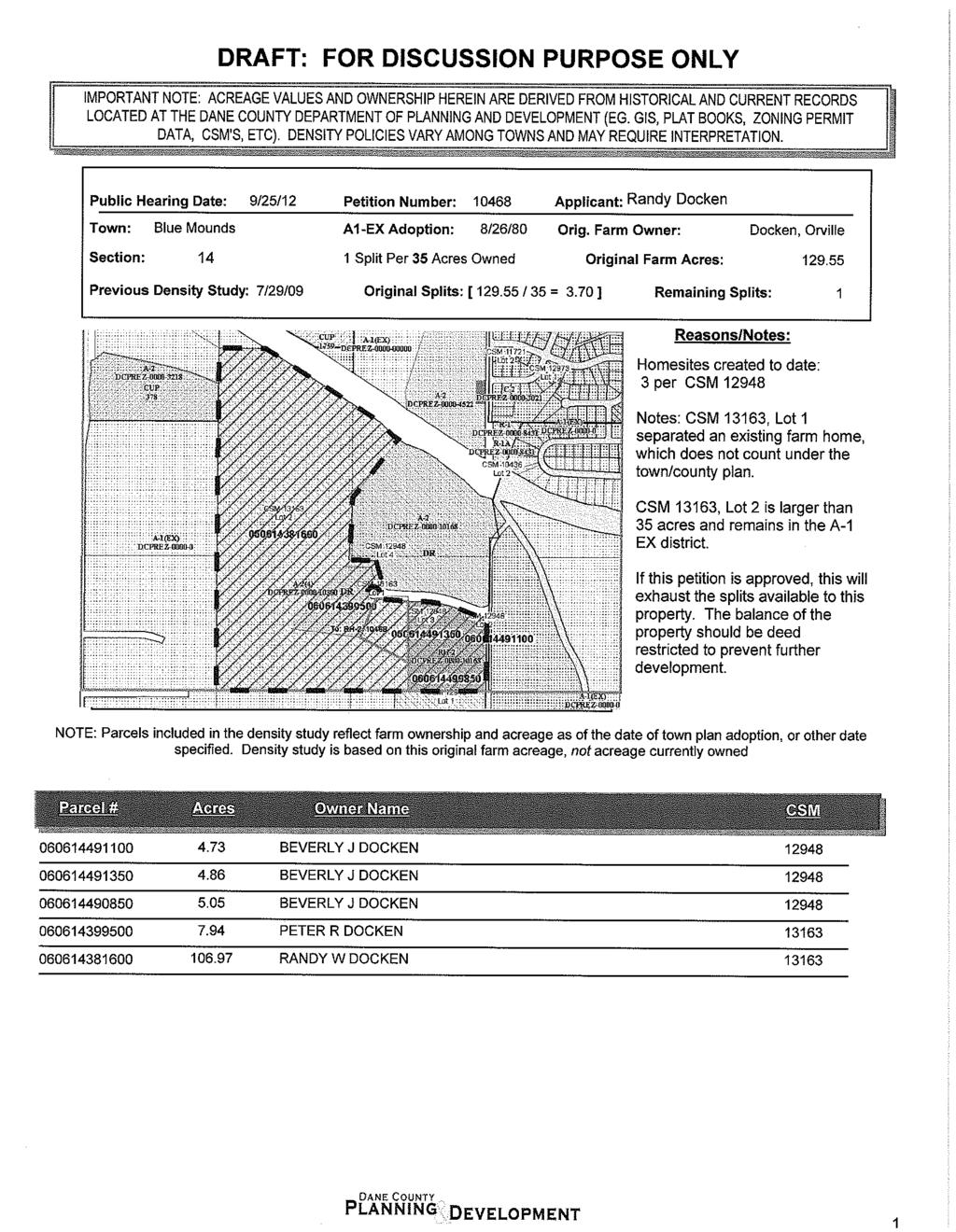
5 Staff Report Zoning and Land Regulation Committee Public Hearing: September 25, 2012 October 23, 2012 Zoning Amendment: A-1EX Agriculture District to RH-2 Rural Homes District Acres: 4.9 Survey Req. YES Reason: Create one residential lot Petition: Rezone Town/sect: Blue Mounds Section 14 Applicant Randy Docken Location: 2469 Docken Road Description: The applicant would like to create a residential lot from the previous 167-acre farm. The estate of this farm was divided in half in There were 4 lots create in 2010 under Zoning Petition #10168 and the separation of the farm house under Petition #10300 in Observations: The southern portion of the proposed lot has slopes exceeding 12%. A small portion of the property (area by the street) consists of Class II soils. Town Plan: The property is in the Agricultural Preservation District. One housing density right remains on the original farm. The housing density rights will be exhausted on the original farm. The proposal appears to meet the non-farm site standards found in the Town Comprehensive Plan. Staff: The proposal meets the dimensional standards of the zoning district. Staff suggests placing a deed restriction on the remaining A-1Exclusive property to prohibit further residential housing. Note: The RH-2 Zoning District limits livestock to one (1) animal unit per full acre. Town: Approved with no conditions.
6
7
8

9 Staff Report Zoning and Land Regulation Committee Public Hearing: September 25, 2012 October 23, 2012 Zoning Amendment: A-1EX Agriculture District to RE-1 Recreational District Acres: 1.0 Survey Req. No Reason: Zoning compliance for structures Petition: Rezone Town/sect: Medina Section 12 Applicant Trek Trails LLC Location: 1200 feet East of 5982 Cherry Lane DESCRIPTION: Trek Bicycle Corporation would like to construct small accessory building on their 87-acre property. The primary purpose of the building will be for storage of land maintenance equipment. The building may also be used as part of testing and development process for corporate products. OBSERVATIONS: The investment property is currently in the managed forestland program. This includes 25 acres of forest and 56 acres of planted prairie land. A small portion of the property has defined riding trails that are used for bicycle product testing and development on an occasional basis. The majority of the rezoning area consists of Class II soils. No other sensitive environmental features observed. TOWN PLAN: The area is designated in the Agricultural Preservation Area. The proposal appears to meet Town Comprehensive Plan Policies. STAFF: The proposal meets the dimensional standards of the zoning district. TOWN ACTION: Approved with no conditions.
10
11
12
13 KERRY D ZAJICEK 10 WILLIAM J OSBORNE MICHAEL W PACHE 35 Canal Rd JAMES KRAUSE 40.2 CHARLES F MAENNER 36.7 EDUARD H STRAUBHAAR 29.4 EDUARD H STRAUBHAAR 26.5 Town of Medina LEWELLIN FAMILY TR 5 CHARLES F MAENNER 1 CHARLES F MAENNER 19.7 TREK TRAILS LLC 86.9 LEWELLIN FAMILY TR 30.5 Legend Significant Soils Class Class 1 Class 2 Steep Slopes Percent Slope 12 to less than and greater Feet Petition Trek Trails LLC
14

15 Staff Report Zoning and Land Regulation Committee Public Hearing: September 25, 2012 October 23, 2012 Zoning Amendment: A-1EX Agriculture District to R-1A Residence District Acres:1.81 Survey Req. Yes Reason: Separation of residence from the farm Petition: Rezone Town/sect: Oregon Section 4 Applicant Goodspeed Holdings LLC Location: 1481 County Highway D DESCRIPTION: The petitioner would like to separate the farmhouse from the 80 acres of farmland they recently a. OBSERVATIONS: The entire 80 acres consists of Class I and II soils. There is a house and an accessory building in the proposed zoning area. No other sensitive environmental features observed. TOWN PLAN: The area is designated as a Rural Preservation Area. The separation of the farm house from the farmland does not count as a housing density right (split). County Highway: CTH D is a controlled access highway. No new accesses will be permitted. STAFF: The proposal meets the dimensional standards of the zoning district. TOWN ACTION: Approved conditioned upon a joint driveway agreement being recorded on the existing driveway.
16

17
18
19 PETERSON TR, PHILIP L & CAROL L 40 HARRIS REVOC TR, EMILY J 38.5 LARRY E ROOSLI 35.9 GOODSPEED HOLDINGS LLC 38.1 Town of Oregon GOODSPEED HOLDINGS LLC 38.7 REBECCA J MESDJIAN 40.1 MARK L WALDVOGEL LARRY E ROOSLI 40.2 DAVID C GOODSPEED ROBERT G STERLING ") D REBECCA J MESDJIAN 40.2 DAVID C GOODSPEED TIMOTHY J YANACHECK Legend Significant Soils Class Class 1 Class 2 Steep Slopes Percent Slope 12 to less than and greater Feet Petition Goodspeed Holdings
20

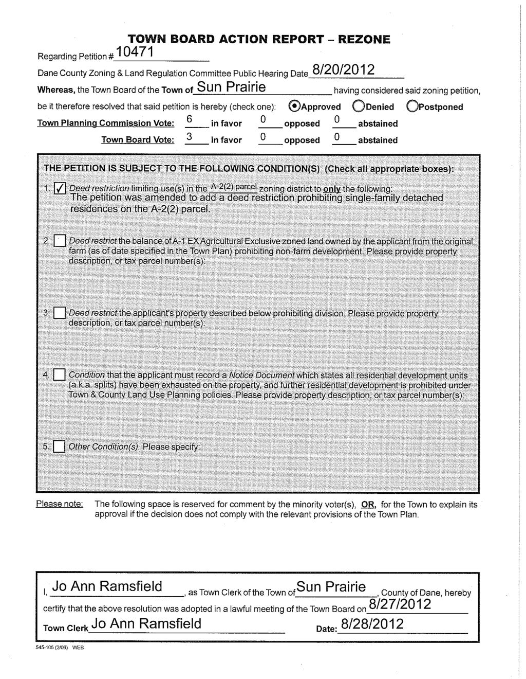
21 Staff Report Zoning and Land Regulation Committee Public Hearing: September 25, 2012 October 23, 2012 Zoning Amendment: A-1ex Agriculture District to R-1 Residence District and A-2(2) Agriculture District Acres: 0.95, 2.98 Survey Req. Yes Reason: Separation of existing residence Petition: Rezone Town/sect: Sun Prairie Section 34 Applicant Rademacher Living TR, Bruce & Shelly Location: 5007 County Highway TT DESCRIPTION: The petitioner would like to separate the farmhouse from the 80 acres of farmland. The petitioner is not intending to construct a residence on the proposed A-2(2) parcel. OBSERVATIONS: Almost the entire 80 acres consists of Class II soils. No other significant sensitive environmental features observed. A remnant parcel is being created due to the highway separating it from the other farmland. TOWN PLAN: The property is located in the Agricultural Preservation Area. The separation of an existing farm residence from the farmland does not count as a housing density right per the town plan policies. The Town Plan allocates no more that 11 home sites (housing density) to be created in No additional home sites are intended as part of this petition. County Highway: CTH TT is a controlled access highway. No new accesses will be permitted. STAFF: Staff suggests placing a deed restriction on the A-2(2) to prohibit residential housing. TOWN ACTION: Approved conditioned upon deed restricting the A-2(2) parcel to prohibit residential housing.
22
23
24 JOSEPH W KALTENBERG 40 JOSEPH W KALTENBERG 40 REDFIELD S MITCHELL 40 REDFIELD S MITCHELL 40 REDFIELD S MITCHELL 40 A-1(EX) JOSEPH W KALTENBERG RADEMACHER LIVING TR, BRUCE & SHELLY 40 JOSEPH W KALTENBERG 36.9 THOMAS R WENDORF R ") TT RADEMACHER LIVING TR, BRUCE & SHELLY 40 Creek Haven Rd JON B NATVIG 0.92 RH-1 LAWRENCE STAVA 0.92 LAWRENCE STAVA 0.93 A-1(EX) GARY L SMITH 1.9 DAVID O OBERG 1.2 R-1 JOSEPH E PETERSON 0.93 JOSEPH W KALTENBERG 28.3 JON M AHLGRIM 0.92 JASON I PUNZEL 0.92 DOUGLAS J GRIM 0.92 DAVID F BATTERMAN 0.92 JOSEPH W KALTENBERG 28.3 RADEMACHER LIVING TR, BRUCE & SHELLY 40 GRADY LIVING TR 25 DAVID C OSWALD 1.97 MARJORIE A POWELL 2.01 Legend Significant Soils Class Class 1 Class 2 Steep Slopes Percent Slope 12 to less than and greater Feet Petition Rademacher Living Trust

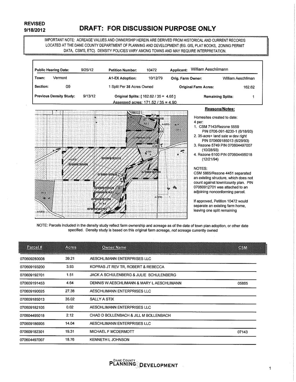
25 Staff Report Zoning and Land Regulation Committee Public Hearing: September 25, 2012 October 23, 2012 Zoning Amendment: A-1EX Agriculture District to A-2 Agriculture District Acres: 20.0 Survey Req. Yes Reason: Separation of existing residence Petition: Rezone Town/sect: Vermont Section 9 Applicant Aeschlimann Enterprises LLC Location: 4473 Blue Mounds Trail DESCRIPTION: The petitioner would like to separate the farm house with an accompanying 20 acres of land from the remaining 82-acre farm. OBSERVATIONS: There is an existing house and 4 agricultural accessory buildings located on the northern portion of the proposed 20-acre land division. Steep slope topography is present on the land located in southern portion of the property. The wooded area by Blue Mounds Trail has slopes in excess of 20% grade. No other sensitive environmental features observed. TOWN PLAN: The property is located in the Agricultural Preservation Area. The Town Plan also identifies this location as an area with Restrictions of Homesites due to its topography. There have been four housing density rights used from the original farm thus far. The separation of the original farm house from the farm does not count as a housing density right per the Town s Density policies. One housing density right will remain on the remaining property. STAFF: The proposal meets the dimensional standards of the zoning district. Animal units are unlimited on parcels over 16 acres in size within the A-2 Zoning District. TOWN ACTION: Approved with no conditions.
26

27
28
29 4 Blue Mounds Trl 9 Pleasant Valley Rd Legend Significant Soils Class Class 1 Class 2 Steep Slopes Percent Slope 12 to less than and greater ,000 Feet Petition Aeschlimann Enterprises
30

31 Staff Report Zoning and Land Regulation Committee Public Hearing: September 25, 2012 October 23, 2012 Zoning Amendment: A-1EX Agriculture District to RH-3 Rural Homes District Acres:26.97 Survey Req. Yes Reason: Creating two residential lots Petition: Rezone Town/sect: Cross Plains Section 16 Applicant Thomas H Adler Location: 4062 Observatory Road DESCRIPTION: The petitioner would like to correct prior illegal land divisions in order to create two conforming residential lots. The proposed northerly lot will be sold to a third party at some point in time. OBSERVATIONS: There is an existing single-family house and shed on the property. The existing house gains access from an existing joint driveway agreement between the petitioner and the neighbor to the north. The driveway has been extended to gain access to the rear of the proposed northerly lot. The property has steep slope topography present on the northern and southern boundaries. Most of the property is wooded except for a cropped field in the northeast corner. No sensitive environmental features observed. TOWN PLAN: The area is designated as a Agricultural Preservation Area. The proposed corrective actions will bring the property into compliance with the Town s Housing Density Policies. STAFF: The proposed lots meet the dimensional standards of the zoning district. TOWN ACTION: Approved with no conditions.
32
33
34
35
36 Observatory Rd Legend Significant Soils Class Class 1 Class 2 Steep Slopes Percent Slope 12 to less than and greater Feet Petition Adler

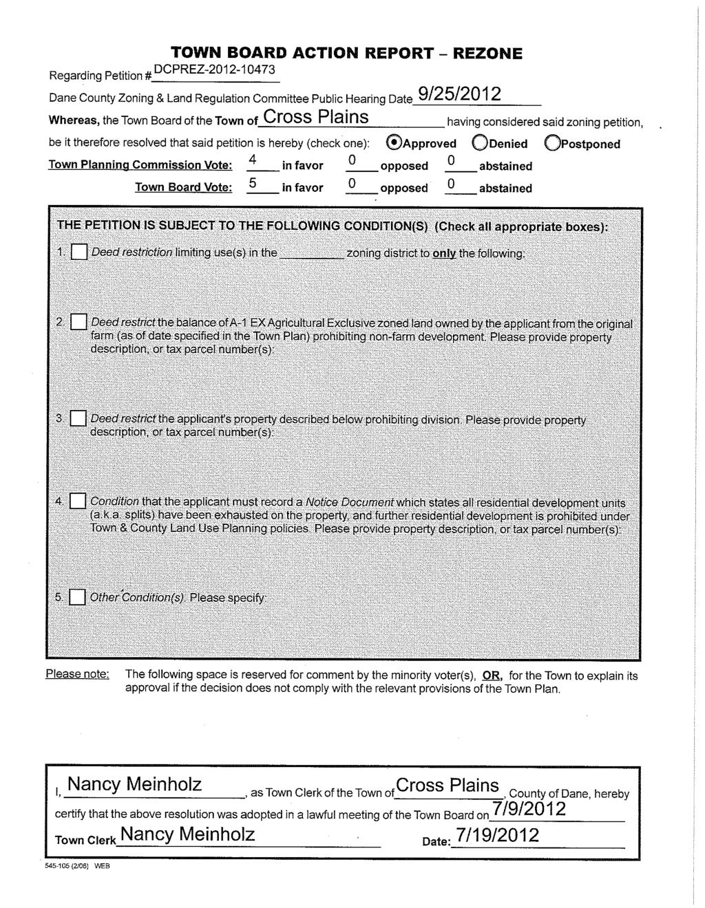
37 Staff Report Zoning and Land Regulation Committee Public Hearing: September 25, 2012 October 23, 2012 Zoning Amendment: A-1ex Agriculture District to C-2 Commercial and A-4 Agriculture District Acres: 2.5 and 12.5 Survey Req. Yes Reason: Commercial area needed for additional employee parking and equipment storage Petition: Rezone Town/sect: Verona Section 19 Applicant Joel G Grant Location: 2416 Spring Rose Road DESCRIPTION: Maple Leaf Landscaping would like to increase the size of their facility in order to accommodate their expanding business. The area will be used for the parking employee vehicles and additional storage for their fleet of landscaping vehicles. The southern portion of the property is currently being used to grow landscaping plants. OBSERVATIONS: The property fronts along US Highway 18/151 and has been used as a landscaping business for approximately 10 years. The area is in the process of being redesigned as part of the DOT Dodgeville to Verona Freeway Conversion project. The plan involves terminating the connection of Spring Rose Road to 18/151 and the installation of a frontage road paralleling 18/151. See attached plan. The frontage road will be placed approximately 100 feet south of current commercial zoning district boundary. This phase of the highway project is slated for No sensitive environmental features observed on the property. TOWN PLAN: The Town Plan designates this location as a commercial area. The minor expansion of the commercial enterprise appears to be consistent with the Town Comprehensive Plan and will fall in line with future infrastructure plans. STAFF: The proposal meets the dimensional standards of the zoning district. Staff suggests limiting the land uses on the property as noted on the existing commercial zoning, see Petition #9257. It is also suggested to prohibit billboard signs on the property. STAFF UPDATE: The zoning boundary has been reduced from 2 acres to a 1.07-acre area as per attached plan. In addition, a landscaped berm has been recently installed to address neighbors concerns. TOWN ACTION: Approved with conditions.
38 A-1(EX) C-2 LC-1 C Town of Springdale 2385 Town of Verona A Spring Rose Rd A-1(EX) Legend Significant Soils Class Class 1 Class 2 Steep Slopes Percent Slope 12 to less than and greater Feet Petition Grant Maple Leaf


39 BERGLUND LIVING TR, KEITH W MICHAEL A SIMON WI DNR STEVEN S LINGARD JON K STILLER ROBERT A HOFFMAN RALPH GUST HOWARD C GUST DALE ZIEGLER DODGEVILLE TO VERONA BERGLUND LIVING TR, KEITH W ROBERT A HOFFMAN ROBERT A HOFFMAN ROBERT A HOFFMAN BERGLUND LIVING TR, KEITH W ROBERT A HOFFMAN US 18/151 FREEWAY CONVERSION PLAN ROBERT W ANDERSON BERGLUND LIVING TR, KEITH W HOWARD C GUST ROBERT A HOFFMAN 1/27/12 ROBERT A HOFFMAN BONNIE L ALBRIGHT THOMAS M DIEDERICH LINUS R HELLENBRAND JAMES K COOPER ROBERT A HOFFMAN TOWN OF SPRINGDALE ROBERT A HOFFMAN TOWN OF VERONA ROBERT A HOFFMAN HOWARD C GUST HOWARD C GUST LINUS R HELLENBRAND GREGORY A ANDERSON JOHN J HENSEYKEVIN STAMPFLI CONNIE A DARGA JAMES AUBART CATHERINE A MELLUMBRANDON CRUSE RUSSELL A CHESMORE CHARLES E FLOOD LANCE A STEIN JOHN W RADER ROBERT J EITH DOUGLAS W WOLF GEORGE A PLEIMLING TIMOTHY J FECHT WILLIAM K GARFOOT DAIRY RIDGE RD HOWARD C GUST PAUL NEESS KERRY R BOLLIG DAVID J ENGELKE TED J LOCHER RUSSELL R GUST GUST LIVING TR JAMES J STEPHENS LINUS R HELLENBRAND JAMES J STEPHENS ANTHONY G ENDRES JAMES G KOVACS NICK V RICCI GUST TR ANN E RIFENBERGRONALD R NICHOLSON JAN R LAMARCHEMATTHEW W BEYER GUST TR GUST TR GUST LIVING TR JAMES J STEPHENS LINUS R HELLENBRAND GUST LIVING TR GUST LIVING TR GUST TR GUST TR THOMAS R GUST THOMAS R GUST CHRISTOPHER W MILLER GUST LIVING TR ANTHONY DANNINGER CLYDE L HELLENBRAND ANTHONY DANNINGER ANTHONY DANNINGER JAMES A ESSER ROGER F DISCH ROGER F DISCH THOMAS R GUST JOEL G GRANTTHOMAS GUST MAPLE LEAF INC InI{ GUST LIVING TR JAMES A RINDFLEISCH TIMOTHY W HAYES MATTHEW W REIFDANIEL W KEYES JEFFREY M HANSON GREGORY T BASS JOHN C KWITEK DENNIS C MIDTHUN DENNIS C MIDTHUN Legend ERIC D BIRSCHBACH RYAN T FRONEK PHILIP D HOWE RANDALL T MARKS ROSS A PEDERSEN ROSS A PEDERSEN MICHAEL H VAN SUSTEREN MICHAEL H VAN SUSTEREN RANDY W LOWMASTER FARLEY REV TR Proposed Roads Municipalities US 151 Parcels HIDDENDALE TRUST MICHAEL S DILLIS BRIAN A RAFFEL JEFFREY YAPP MARILYN S ZURBUCHEN PERKINS LIVING TR Cemetery CARL C RALSTON ROBERT L GEIMER DALE N CHESTNUT GEORGE F HAGENAUER DALE N CHESTNUT RACHEL A CHESTNUT MARK C WOPPERT GUST TR FARLEY REV TR GUST TR MARILYN S ZURBUCHEN MARILYN S ZURBUCHEN CARL L CURE JOEL G GRANT RICHARD A BECKWITH BRETT ZAHLER BETTY J STIVARIUS ADRIAN T SMITH JOHN K ZIMMER MERLIN L SLABACK CHRIS C ZURBUCHEN JAMES C VON ESCHEN ROBERT J BLASDEL SPRING ROSE RD THEODORE S SMITH SCOTT E PUTNEY JULIAN O RHINER MARILYN S ZURBUCHEN GUST TR MARILYN S ZURBUCHEN THOMAS R GUST THOMAS R GUST NEW FRONTAGE ROAD WITH 66' RIGHT-OF-WAY JULIAN O RHINERFeet ROGER F DISCH CARL L CURE ROGER F DISCH WILLIAM RESOP JAMES C VON ESCHEN ROBERT J BLASDEL WILLIAM RESOP RICHARD A BECKWITH SPRING ROSE RD FARM LAND AAJ LLC FARM LAND AAJ LLC InI{ JULIAN O RHINER JULIAN O RHINER THOMAS R GUST MAPLE LEAF INC THOMAS If GUST JOEL G GRANT DONNA MAE PIAZZA JULIAN O RHINER WILLIAM RESOP JOEL G GRANT SUGAR RIVER INVESTORS I LLC NEW FRONTAGE WILLIAM RESOP ROAD WITH 66' RIGHT-OF-WAY WILLIAM RESOP Miles L

40

41

42
43
44

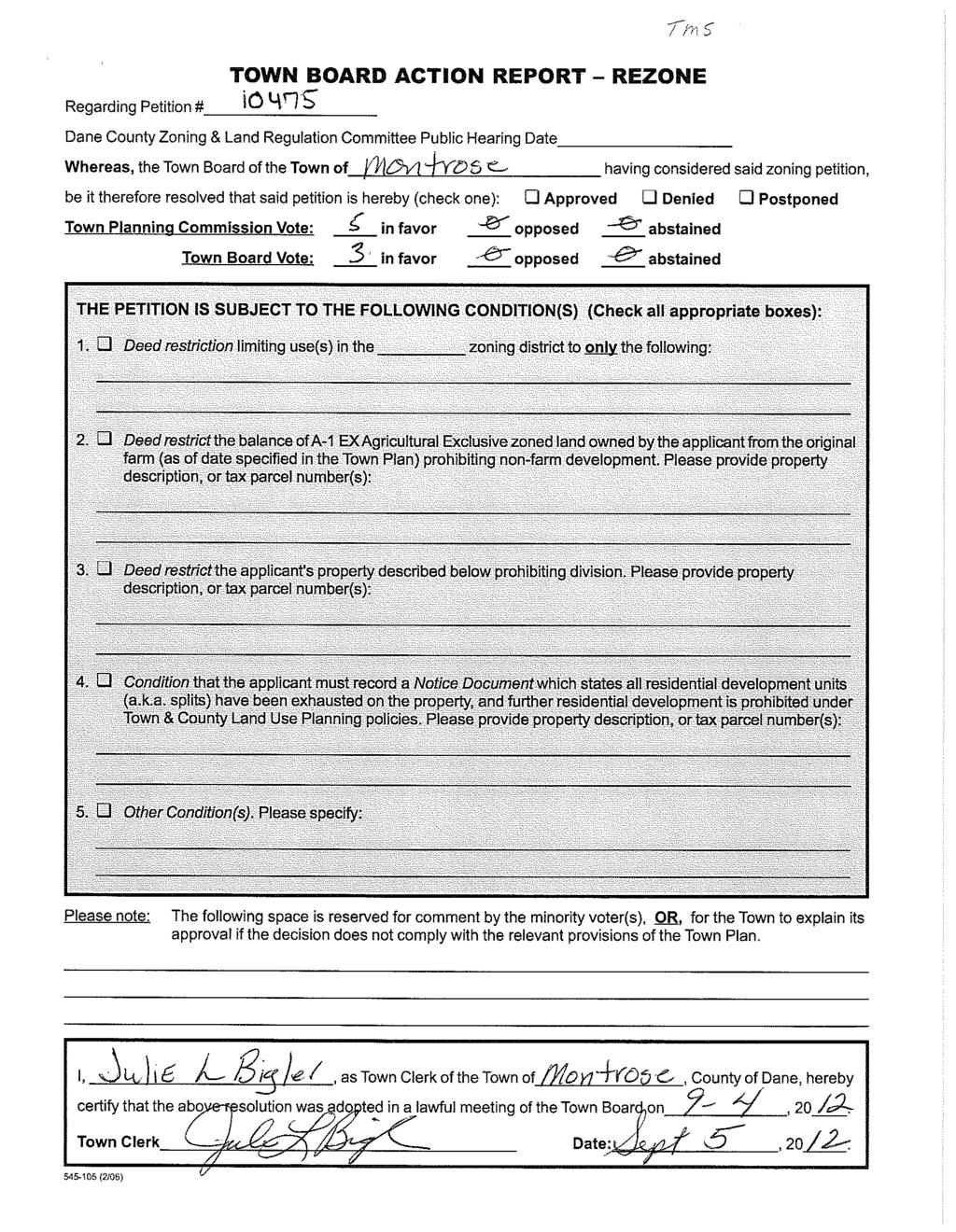
45 Staff Report Zoning and Land Regulation Committee Public Hearing: September 25, 2012 October 23, 2012 Zoning Amendment: A-1EX Agriculture District to A- 2(1) Agriculture District Acres:1.3 Survey Req. Yes Reason: Create one residential lot Petition: Rezone Town/sect: Montrose Section 18 Applicant TMS Investment LLC Location: 7712 County Highway A DESCRIPTION: The petitioner would like to construct a new residence on a property that is currently separated into two parcels. OBSERVATIONS: There was an existing building on the property that was destroyed by fire in The building was unable to be reconstructed due it its close proximity to Highway A. The property is set on a hillside with slopes ranging from 8% to 18%. No other sensitive environmental features observed. TOWN PLAN: The property is located in the Agricultural Preservation Area. The development policies discourage development on Class I&II soils and the separation of fields. There are no topography standards listed. The proposal appears to meet development standards under the Town Comprehensive Plan policies. County Highway: CTH A is not controlled access highway. Any change of use for existing access points or and new access points will be required from Dane County Highway Department. Staff suggests contacting Dane County Highway prior to the redevelopment of this parcel. STAFF: The proposal meets the dimensional standards of the zoning district. TOWN ACTION: Approved with no conditions.
46
47
48
49
50
51 A-1(EX) Town of Montrose RH-3 RH-3 A-1(EX) Legend Wetlands > 2 acres Steep Slopes Percent Slope 12 to less than and greater Feet Petition TMS Investments
52

53 Staff Report Zoning and Land Regulation Committee Public Hearing: September 25, 2012 October 23, 2012 Zoning Amendment: RH-1 Rural Homes District, A-1ex Agriculture District to A-2(2) Agriculture District Acres:2.8, 0.6 Survey Req. Yes Reason: Add land to existing Certified Survey Map CUP Description: Limited Family business Petition: Rezone CUP 2212 Town/sect: Dane Section 17 Applicant Michael A Endres Location: 7321 Latham Road DESCRIPTION: The petitioner would like to add additional land onto his existing parcel to construct a building for a limited family business. The building will be used to store his agricultural vehicles for his manure spreading business. OBSERVATIONS: There is an existing residence on the property. The entire property will need to be rezoned to A-2 in order to obtain a conditional use permit for a limited family business. No sensitive environmental features observed. The property is located at the ridge of the Town Road surrounded by open fields. The driveway has poor visibility when approaching from the south. TOWN PLAN: The property is located in the Agricultural Preservation Area. The plan will Allow only such commercial and industrial development as is needed to support existing agricultural activities, where it will not result in environmental degradation or conflict with farming operations. STAFF: The proposal meets the dimensional standards of the zoning district. Staff suggests limiting the land uses in the in A-2 Zoning District to single-family residences, agricultural uses, and limited family business to address concerns regarding incompatible uses in the Agricultural Preservation Area. Staff is also suggesting a set of conditions for the conditional use permit that would mitigate any potential nuisances. TOWN ACTION: Zoning: Approved conditioned upon limiting the land uses. CUP: Approved with 10 conditions.

54
55
56
57 1160 Latham Rd A-1(EX) RH A-1(EX) Town of Dane 17 DR RH DR DR Legend Significant Soils Class Class 1 Class ,000 Feet Petition CUP 2212 Endres
58
59
60

61 Staff Report Zoning and Land Regulation Committee Public Hearing: September 25, 2012 October 23, 2012 Zoning Amendment: A-1EX Agriculture District to RH-2 Rural Homes District, A-2(4) Agriculture District, A-4 Agriculture District Acres:25.3, 5.5 and 4.0 Survey Req. Yes Reason: Separate residence and farm buildings from the farm Petition: Rezone Town/sect: Christiana Section 3 Applicant Harland H Hoesly Location: 2998 Fadness Road DESCRIPTION: Applicant proposes to create a new RH-2 zoned residential parcel, and to provide zoning compliance and separate parcel for the existing residence and outbuildings (A-2(4) parcel), as well as the remaining agricultural land (A-4 parcel). OBSERVATIONS: The property consists primarily of Class II and III soils. There is a drainage ditch located in the SE portion of the proposed A-4 parcel. TOWN PLAN: The property is located in the town s Agricultural Preservation Area. Development is limited to no more than 1 lot per 35 acres owned as of 5/3/1979. STAFF: As indicated on the density study report, the property remains eligible for one (1) split. Separation of the existing residence and proposed zoning compliance for the remaining ag land does not count toward the density limitation. If the petition is approved, the housing density units will be exhausted. Staff recommends a deed restriction be recorded on the remaining farmland owned by the applicant prohibiting further residential development. TOWN ACTION: Pending
62
63
64 A-1(EX) R-2 Fadness Rd A-2(1) A-1(EX) «73 Town of Christiana RH-1 A-1(EX) Hillcrest Rd R-1 A-1(EX) Legend Significant Soils Class Class 1 Class Feet Wetlands > 2 acres 100-year floodplain Petition Hoesly

65 Staff Report Zoning and Land Regulation Committee Public Hearing: September 25, 2012 October 23, 2012 Zoning Amendment: A-1EX Agriculture District to A-2(2) Agriculture District Acres: 2.0 Survey Req. No Reason: Creating one residential zone area Petition: Rezone Town/sect: Blue Mounds Section 3 Applicant Jon Larson Location: Bergum Road DESCRIPTION: This is the second petition which has been submitted in regards to the development of the Larson property. Mike Dillis would like to purchase the 81 acres of land currently owned by the Larsons. In June, the first zoning petition (#10416) was recommended to be denied by the Zoning and Land Regulation Committee due to excessive driveway length and the development not promoting the health, safety, and general welfare of the public. The petition was withdrawn by the petitioner prior to County Board action. A new petition has been submitted with an alternative on how to address the safety concerns expressed by the Committee. The petitioner is suggesting that an emergency access route be constructed on the southeast corner of the property which would provide a secondary route to the residential site if the need arises. See attached map. OBSERVATIONS: The property consists of two ¼ ¼ sections that are located 450 feet west of Bergum Road. An easement is used to reach the property from Bergum Road. A perennial stream, Elver s Creek, bisects the property. The area by the stream is designated on the FEMA Flood Insurance Maps as a flood hazard area (undetermined). There is a ribbon of Class II soil (Orion Silt Loam) that runs along the banks of the stream. Steep slope topography is associated with the wooded portions of the property. The zoning area will be reached using a 2400-foot long driveway (1100 existing to be constructed). There was an existing dwelling on the property, but this structure was destroyed by a fire in 2011.
66 TOWN PLAN: The 1981 Plan shows the property located in the Agricultural Preservation Area. The plan policies express concerns regarding the placement of houses and driveways on steep slope topography, the length of access routes to home sites, and disruption to natural features of the land (See attached pages 8-9). Staff: TOPOGRAPHY: Staff has reviewed the proposal regarding the development of the land in relation to slopes. It appears that the drive path will not be in an area with 12% slopes. The steeper slopes are part of the forested area. FLOODPLAIN: A portion of the property is located in Zone A as depicted on FEMA Flood Insurance Rate Map (FIRM) panel number C0345-G. The Zone A is a flood hazard area with an undefined flood elevation. The map shows only an approximate area of flood hazard. A more defined delineation of the limits of the flood hazard area has been performed using FEMA Technical Guide 265 for establishing flood elevations in Zone A areas. A defined area was set with the assumption of the stream flooding no higher than 6 feet above normal flow elevation. It appears that the driveway and development area is outside the flood hazard area. SOILS: The zoning boundary area consists of only 4% Class II soils. TOWN ACTION: Approved with comments.
67
68

69
70
71
72 RH-1 A-1(EX) RH-1 Town of Vermont RH-4 ") JG RH RH-2 RH-3 A-1(EX) A-1(EX) A-1(EX) RH-4 A-1(EX) RH-1 North Rd Town of Blue Mounds A-1(EX) RH-4 R-1A RH-4 A-2 A-2(2) RH-4 Bergum Rd RH-1 A-2 RH-1 RH-2 RH-1 A-2 Legend ,000 2,000 Feet Perennial Stream Intermittent Stream Constructed Drainage BuildingFootprint Petition Larson / Dillis

73 Staff Report Public Hearing: September 25, 2012 October 23, 2012 Zoning Amendment: A-1 Agriculture District to A-1 Agriculture District Petition: CUP 2214 Town/sect: Bristol Section 24 Zoning and Land Regulation Committee Acre: Survey Req. No Applicant Russel R Weisensel Reason: 195 self-support lattice cell tower Location: 7018 Twin Lake Rd DESCRIPTION:T-Mobile proposes to construct a 195 tall self-support lattice communications tower to fill in a gap in coverage along the HWY 151 corridor. The tower would be located within a 6,400 square foot fenced area on the Weisensel property. The tower would not be lighted. OBSERVATIONS: No sensitive environmental features observed on the site. TOWN PLAN: The property is located in an agricultural preservation area. STAFF: The applicant has demonstrated that there are no existing towers or other suitable tall structures in the vicinity that could be utilized to achieve the carrier s coverage objectives. The county s Radio Frequency (RF) engineering consultant has reviewed the proposal and finds that it satisfies the minimum standards of the county ordinance. Please see attached staff report for additional information and recommended conditions. TOWN ACTION: Approved.
74 TOWN BOARD ACTION REPORT CONDITIONAL USE PERMIT Regarding Petition # Dane County ZLR Committee Public Hearing Whereas, the Town Board of the Town of having considered said conditional use permit application, be it therefore resolved that said conditional use permit is hereby (check one): APPROVED DENIED (IF DENIED, PLEASE COMPLETE FINDINGS SECTION ON PAGE 2) PLANNING COMMISSION VOTE: In Favor Opposed TOWN BOARD VOTE: In Favor Opposed Whereas, in support of its decision, the Town Board has made appropriate findings of fact that the standards listed in section (2)(h), Dane County Code of Ordinances, and section (3)(a), if applicable, are found to be (check one): SATISFIED NOT SATISFIED (PLEASE COMPLETE FINDINGS SECTION ON PAGE 2) THE CONDITIONAL USE PERMIT IS SUBJECT TO THE FOLLOWING CONDITION(S): PLEASE NOTE: The following space, and additional pages as needed, are reserved for comment by the minority voter(s), OR, for the Town to explain its approval if the decision does not comply with the relevant provisions of the Town Plan. I,, as Town Clerk of the Town of, County of Dane, hereby certify that the above resolution was adopted in a lawful meeting of the Town Board on, 20. Town Clerk, 20. Date
266-4251, Rm. 116 TO: Dane County Zoning & Land Regulation Committee (ZLR) Records & Support (608)266-4251, Rm.")
 #2214 proposed 195 T-Mobile cell tower in the A-1 Agricultural district, section 24, Town of Bristol Ray Shinkle (Agent for T-Mobile) Roger Lane, Dane County")
75 Dane County Planning and Development Department Room 116, City-County Building, Madison, Wisconsin Fax (608) MEMORANDUM Community Development (608) , Rm. 421 Planning (608) , Rm. 116 TO: Dane County Zoning & Land Regulation Committee (ZLR) Records & Support (608) , Rm. 116 FROM: Majid Allan, Senior Planner DATE: September 18, 2012 Zoning (608) , Rm. 116 RE: CC: Conditional Use Permit (CUP) #2214 proposed 195 T-Mobile cell tower in the A-1 Agricultural district, section 24, Town of Bristol Ray Shinkle (Agent for T-Mobile) Roger Lane, Dane County Zoning Administrator Dennis O Laughlin, Dane County Board Supervisor, District 20 Sandy Klister, Clerk, Town of Bristol H:\Zoning\ZLR\PHFORMS\2012\2012 Cell tower staff reports\cup 2214 (Town of Bristol) - T-Mobile cell tower staff report.doc
76 Proposal Summary Tower height / type: 195 tall self-support cell tower (+ min. 2 lightning rod) in the A-1 district, on a 6,400 square feet fenced lease area. T-Mobile s equipment would be located at 195 above ground level (AGL), and the tower would accommodate a total of three (3) additional collocation spots on tower at 185, 175, and 165. The tower would not requiring lighting. Location: 7018 Twin Lane Road, section 24, Town of Bristol. The proposed tower would be located approximately 230 away from the Russell and Mary Weisensel residence. The closest other neighboring residence is located approximately 1,670 to the south along Twin Lane Road. Potential for collocation: US Cellular has indicated that they are interested in possibly collocating equipment on the proposed tower in the near future. Staff worked with US Cellular and T-Mobile to verify that the proposed site would be suitable for such future collocation (see enclosed letter from US Cellular s agent). Reason for tower: T-Mobile is proposing the new tower because there is no other existing tower or other tall structure in the vicinity that could be utilized to meet the company s objective to improve coverage in the highway 151 corridor in northeast Dane County. T- Mobile is making the case for the new tower under (2)(a): No existing communication tower is located within the area in which the applicant's equipment must be located. Radio Frequency (RF) Engineering Summary RF Engineer s recommendation: Approve. Evans Associates has completed a review of the proposed tower and finds that, the proposed T-Mobile tower ML94464B should be approved in the Town of Bristol, as it will improve local cellular coverage, as well as prove to be an excellent site for co-location with U.S. Cellular. The engineering report finds that the proposed tower meets the county ordinance standards and recommends approval of the CUP. Staff Recommendations Approve with conditions Pending consideration of any issues raised at the public hearing by neighboring property owners or other interested parties, staff recommends that the ZLR Committee approve CUP #2214 subject to the conditions listed below. The consultant s recommendations are included in the list of recommended conditions, below. The following pages of this report address standard CUP considerations, common towerrelated issues, and potential conditions of approval. H:\Zoning\ZLR\PHFORMS\2012\2012 Cell tower staff reports\cup 2214 (Town of Bristol) - T-Mobile cell tower staff report.doc
77 Conditional Use Permit Considerations. When granting CUPs, the ZLR and respective town board need to find that the proposed conditional use satisfies the following six standards outlined under (2)(h) of the D.C. Ords.: 1. That the establishment, maintenance, or operation of the conditional use will not be detrimental to or endanger the public health, safety, comfort or general welfare. 2. That the uses, values and enjoyment of other property in the neighborhood for purposes already permitted shall be in no foreseeable manner substantially impaired or diminished by establishment, maintenance or operation of the conditional use. 3. That the establishment of the conditional use will not impede the normal and orderly development and improvement of the surrounding property for uses permitted in the district. 4. That adequate utilities, access roads, drainage and other necessary site improvements have been or are being made. 5. That adequate measures have been or will be taken to provide ingress and egress so designed as to minimize traffic congestion in the public streets; and 6. That the conditional use shall conform to all applicable regulations of the district in which it is located. Section , Procedure and Standards for the Placement, Construction or Modification of Communication Towers. Dane County Zoning Ordinance section that regulates the permitting of communication towers in Dane County. The primary intent of s is to minimize the total number of communication towers in Dane County by utilizing, to the extent practical, all existing structures. Section (2) states that: No CUP shall be issued unless the applicant presents to the committee credible evidence establishing to a reasonable degree of certainty [at least one of] the following: (a) No existing communication tower is located within the area in which the applicant's equipment must be located; or (b) No existing communication tower within the area in which the applicant's equipment must be located is of sufficient height to meet applicant's requirements and the deficiency in height cannot (c) be remedied at a reasonable cost; or No existing communication tower within the area in which the applicant's equipment must be located has sufficient structural strength to support applicant's equipment and the deficiency in structural strength cannot be remedied at a reasonable cost; or (d) The applicant's equipment would cause electromagnetic interference with equipment on the existing communication tower(s) within the area in which the applicant's equipment must be located, or the equipment on the existing communication tower(s) would cause interference with the applicant's equipment and the interference, from whatever source, cannot be eliminated at a reasonable cost; or (e) (f) The fees, costs or contractual provisions required by the owner in order to collocate on an existing communication tower are unreasonable relative to industry norms; or The applicant demonstrates that there are other factors that render existing communication towers unsuitable or unavailable and establishes that the public interest is best served by the placement or construction of a new communication tower. In the section referenced above, the burden of proof is placed upon the applicant. The applicant must provide to the Committee credible evidence establishing to a reasonable degree of certainty that at least one of those six conditions above is met. The applicant is making its case under s (2)(a) above. There are no towers in the area where T-Mobile is seeking to provide coverage. H:\Zoning\ZLR\PHFORMS\2012\2012 Cell tower staff reports\cup 2214 (Town of Bristol) - T-Mobile cell tower staff report.doc
78 Common Tower Related Issues. There are a number of issues that are commonly associated with the siting, operation, and maintenance of cell towers. Below is a brief synopsis of these issues in the context of the tower proposed under CUP #2214. Air navigation. There are no public or private airports within 3 miles of the proposed CUP area. The applicant is in the process contacting the FAA and WISDOT Bureau of Aeronautics to obtain a determination of no hazard to air navigation. Fall-down radius. The fall-down radius is essentially the area around a tower that could be affected in the event that the tower fell down. A conservative radius to use is 125 percent of the proposed tower height, which in this case is feet (125 percent of 195 ft.). The Weisensel residence and two outbuildings are located just within this radius (~230 feet away). Ice-fall radius. During the winter months, ice can build up on towers and subsequently melt and fall of off the tower affecting the ground and structures in close proximity to the tower. Falling ice can drift further from the base of a structure due to strong winds. A conservative radius to evaluate for falling ice is 50 percent of the proposed height of the tower, which in this case is approximately 97.5 feet: there are no structures within this radius that could be affected by falling ice. Visual aesthetics. This is a highly subjective issue and one of the most significant points of contention often associated with new communication tower requests. Due to the relatively rural location and a distance of over 1,600 from the nearest rural residence (south on Twin Lane Rd), visual impact at this site should be minimal except to passing motorists. The applicant has submitted photo simulations that illustrate the potential visual impact from various locations surrounding the property. Electromagnetic radiation. The issue of electromagnetic radiofrequency (RF) emissions is commonly raised in response to communication tower proposals. However, an evaluation of the issue is somewhat outside of the County s jurisdiction given that there are no relevant County regulations; Department staff do not have the technical capabilities to evaluate and comment on this issue; and it is regulated and governed by the FCC through the federal licensing and permitting process. This is a lowdensity rural / agricultural area, which should mitigate any negative affects associated with RF emissions. If so desired, the Committee/County has the option of referring specific questions to the County s contracting RF engineering consultant, Evans Associates. Otherwise, the issue is deemed to be governed entirely by the FCC. H:\Zoning\ZLR\PHFORMS\2012\2012 Cell tower staff reports\cup 2214 (Town of Bristol) - T-Mobile cell tower staff report.doc
79 Potential Conditions of Approval. Should the Committee choose to approve the CUP application, below is a list of potential conditions. 1. The primary use of the communication tower permitted under Conditional Use Permit No shall be for the transmission and reception of cellular/pcs wireless voice / data communications, and related telecommunications equipment. 2. The communication tower placed, constructed or modified under Conditional Use Permit No shall accommodate the collocation of telecommunications equipment for at least three (3) additional telecommunications providers. At least two (2) of the three (3) collocation spots shall be made available at a minimum height of 150 feet above ground level (AGL), upon request of another carrier. The maximum height of the tower shall not exceed 199 feet above ground level. 3. The minimum of three (3) collocation sites required hereunder need not be available on the tower as initially placed, constructed, or modified, provided that the tower will support the later addition of the collocation sites as specified in condition #2, above. 4. Collocation sites required hereunder shall, upon request, be made available by the holder of Conditional Use Permit No for the mounting of technologically compatible antenna arrays and equipment at the prevailing market rate in the region and upon contractual provisions which are standard in the industry. 5. Subject to further conditions set forth herein as to total floor area and location, the holder of Conditional Use Permit No is permitted to construct a building of no more than 14 feet in height (as defined in section (8) of the Dane County Zoning Ordinance in effect in March 1997) and 314 square feet in floor area for use directly incidental and necessary to the use of the tower. Any other user collocating on the tower permitted herein is permitted to construct a building of no more than 14 feet in height (as defined in section (8) of the Dane County Zoning Ordinance in effect in March 1997) and 314 square feet in floor area for use directly incidental and necessary to the use of the tower. Two or more users of the tower may build a single building with a floor area of no more than 314 square feet per user sharing the building. Buildings constructed or used by tower collocators shall be subject to all conditions established for Conditional Use Permit No.2214, including locational requirements contained in the site plan. 6. The holder of Conditional Use Permit No shall, through ownership, lease, option or other means, at all times have the right to use the land associated with the permitted tower for uses related to the use of the collocation sites required hereunder, including the construction and use of buildings as permitted under paragraph 5 herein. 7. The final site plan(s) and design drawings dated 6/1/2012 and submitted with the CUP #2214 application materials, are fully incorporated herein and continued effectiveness of Conditional Use Permit No is expressly conditioned upon compliance with those plans. 8. Upon written inquiry by the committee, the holder of Conditional Use Permit No shall have the burden of presenting to the committee credible evidence establishing to a reasonable certainty the continued compliance with all conditions placed upon the conditional use permit. Failure to establish compliance with all conditions placed upon the conditional use permit shall be grounds for revocation of the permit. In the event the committee determines that it is necessary to consult with a third party to ascertain compliance with conditions on Conditional Use Permit No. 2214, all reasonable costs and expenses associated with such consultation shall be borne by the holder of said conditional use permit. Failure to pay such costs and expenses or provide information requested by the committee shall be grounds for revocation of the conditional use permit. H:\Zoning\ZLR\PHFORMS\2012\2012 Cell tower staff reports\cup 2214 (Town of Bristol) - T-Mobile cell tower staff report.doc
80 9. The holder of Conditional Use Permit No shall within 30 days of any collocation on the permitted tower provide the committee with written notification of the identity of the collocator and the nature of the equipment installed. Within 30 days of the date on which any collocated use ceases, the permit holder shall provide the committee with written notice of the cessation of such use. Any changes due to collocation or otherwise shall be reviewed by the Zoning Administrator prior to implementation to determine if permits are needed and to determine that such changes are in compliance with terms of the CUP and does not significantly alter the appearance or structural integrity of the tower approved and permitted under this CUP. 10. If at any time the communication tower permitted under Conditional Use Permit No ceases to be used for the primary use, as identified in paragraph 1 above, for a continuous period of 12 months the permit holder shall, upon notification by the committee, dismantle and remove the tower. If the tower is not removed within 30 days of such notification, Dane County may enter upon the premises and remove the tower at the expense of the holder of the conditional use permit. 11. Prior to issuance of the requested conditional use permit, and as a condition of its continued validity, applicant shall provide Dane County with a bond, or evidence of an existing bond, in the amount of $20,000 ensuring performance of applicant's obligation to remove any communication tower, array or any other equipment or structure placed or erected pursuant to the conditional use permit, including payment for such removal by Dane County or its agent, in the event the permit is revoked or the use permitted thereunder ceases for a continuous period of 12 months. Said bond shall expressly state that it will remain in full force and effect for a period of at least six months after the surety provides Dane County written notification of expiration or termination of the surety's obligation under the bond. Applicant shall remove any communication tower, array or any other equipment or structure placed or erected pursuant to the conditional use permit no less than 30 days prior to the termination or expiration of the bond required hereunder. 12. The applicant shall file a Notice of Proposed Construction on Form to the FAA to assure that the self-support lattice tower will not impact air traffic. 13. Contact with Wisconsin DOT Bureau of Aeronautics should be made prior to construction, if it has not already been done, to determine whether notification to that agency is required. 14. All tower components, appurtenances and transmission lines should be securely bonded and grounded to prevent RF interference caused by stray signals. 15. A Wisconsin-licensed Structural Engineer should approve and stamp the tower design, and certify that the tower can support up to three additional cellular/pcs voice / data antenna arrays. 16. The applicant shall utilize a galvanized or painted finish on the tower to minimize visual impact, if permitted by the FAA. 17. The applicant shall paint steel appurtenances the same color as the tower to minimize visual impact. 18. The tower compound area shall be surrounded by a security fence with fabric privacy screening. 19. Failure to comply with any of the aforesaid conditions shall be grounds for the committee to immediately revoke Conditional Use Permit No H:\Zoning\ZLR\PHFORMS\2012\2012 Cell tower staff reports\cup 2214 (Town of Bristol) - T-Mobile cell tower staff report.doc
81 Evans Associates RE: Proposed T-Mobile Wireless Tower ML94464B Sun Prairie, Dane County, WI The color scheme used for the propagation maps is as follows: Green..Excellent Indoor Coverage Yellow Excellent In-Vehicle Coverage Grey....Excellent Outdoor Coverage Blue Weaker Outdoor Coverage IV. RECOMMENDATIONS The following recommendations are made with respect to the T-Mobile tower site: 1. It is the opinion of Evans Associates that the proposed T-Mobile tower ML94464B should be approved in the Town of Bristol, as it will improve local cellular coverage, as well as prove to be an excellent site for co-location with U.S. Cellular. 2. If the tower is approved, all tower components, appurtenances and transmission lines should be bonded securely and grounded to prevent RF interference caused by stray signals. Respectfully submitted, Ralph E. Evans III Primary Consultant Evans Associates Attached Figures Figure Active ASR Tower Locations Figure T-Mobile s Search Ring Figure Site Plan Figure Tower Elevation Figure Existing Coverage without Site ML94464B Activated Figure Proposed Coverage with Site ML94464B Activated Consuling Engineering Report All Rights Reserved 2012 Page 6 of 12

82
 266-4266/266-9083 Fax (608) 267-1540 DANE COUNTY CONDITIONAL USE PERMIT # 2214 THE ZONING AND LAND REGULATION COMMITTEE OF THE DANE COUNTY BOARD PURSUANT TO")
83 Dane County Zoning Division City-County Building 210 Martin Luther King, Jr., Blvd., Room 116 Madison Wisconsin (608) / Fax (608) DANE COUNTY CONDITIONAL USE PERMIT # 2214 THE ZONING AND LAND REGULATION COMMITTEE OF THE DANE COUNTY BOARD PURSUANT TO SECTION (2) OF THE DANE COUNTY CODE OF ORDINANCES DOES HEREBY: GRANT Conditional Use Permit # 2214 for a communications tower pursuant to Dane County Code of Ordinance Sections 10.12(3)(b) and and subject to any conditions contained herein: EFFECTIVE DATE OF PERMIT: PENDING THE CONDITIONAL USE SHALL BE LOCATED ON THE PROPERTY DESCRIBED AS FOLLOWS: A part of the Southwest Quarter (SW1/4) of the Northwest Quarter (NW1/4) of Section Twenty-Four (24), Township Nine (9) North, Range Eleven (11) East, Town of Bristol, Dane County, Wisconsin, containing 6,400 square feet (0.147 acres) of land and being described by: Commencing at the West Quarter Corner of said Section 24; thence N01º W feet along the West line of the NW1/4 of said Section 24; thence N E feet to the point of beginning; thence continuing N E feet; thence S E feet; thence S W feet; thence N W feet to the point of beginning, being subject to any and all easements and restrictions of record. CONDITIONS: 1. The primary use of the communication tower permitted under Conditional Use Permit No shall be for the transmission and reception of cellular/pcs wireless voice / data communications, and related telecommunications equipment. 2. The communication tower placed, constructed or modified under Conditional Use Permit No shall accommodate the collocation of telecommunications equipment for at least three (3) additional telecommunications providers. At least two (2) of the three (3) collocation spots shall be made available at a minimum height of 150 feet above ground level (AGL), upon request of another carrier. The maximum height of the tower shall not exceed 199 feet above ground level. S:\PlanDev\Zoning\ZLR\Conditional Use Permits\CUP #2214 proposed.doc
DANE COUNTY BOARD OF SUPERVISORS
 ZLR Committee Public Hearing Agenda Page 1 of 4 September 25, 2012 DANE COUNTY BOARD OF SUPERVISORS ZONING & LAND REGULATION COMMITTEE PUBLIC HEARING AGENDA Date: Tuesday, September 25, 2012 Time: 7:00
DANE COUNTY BOARD OF SUPERVISORS
 ZLR Committee Work Meeting Agenda Page 1 of 3 November 13, 2012 DANE COUNTY BOARD OF SUPERVISORS ZONING & LAND REGULATION COMMITTEE WORK MEETING AGENDA Date: Tuesday, November 13, 2012 Time: 7:00 P.M.
DANE COUNTY BOARD OF SUPERVISORS
 ZLR Committee Public Hearing Agenda Page 1 of 3 October 25, 2011 DANE COUNTY BOARD OF SUPERVISORS ZONING & LAND REGULATION COMMITTEE PUBLIC HEARING AGENDA Date: Tuesday, October 25, 2011 Time: 7:30 P.M.
DANE COUNTY BOARD OF SUPERVISORS
 ZLR Committee Public Hearing Agenda Page 1 of 3 December 17, 2013 DANE COUNTY BOARD OF SUPERVISORS ZONING & LAND REGULATION COMMITTEE PUBLIC HEARING AGENDA Date: Tuesday, December 17, 2013 Time: 7:00 P.M.
Agenda ZNR Committee Page 1 DANE COUNTY BOARD OF SUPERVISORS
 Agenda ZNR Committee Page 1 DANE COUNTY BOARD OF SUPERVISORS ZONING & NATURAL RESOURCES Agenda Committee Date: APRIL 17 2001 Time: 7:30 P.M. Location: ROOM 2D CCB PLEASE NOTE: Persons requiring an interpreter,
Public Hearing: November 26, 2013 Petition: CUP 2250 Zoning Amendment: Acres:3.78 Survey Req. No Reason: Agriculture Entertainment Wedding barn
 Staff Report Zoning and Land Regulation Committee Public Hearing: November 26, 2013 Petition: CUP 2250 Zoning Amendment: Town/sect: A-1EX Exclusive Agriculture Blue Mounds District to A-1EX Exclusive Section
DANE COUNTY BOARD OF SUPERVISORS
 ZLR Committee Work Meeting Agenda Page 1 of 3 April 12, 2011 DANE COUNTY BOARD OF SUPERVISORS ZONING & LAND REGULATION COMMITTEE WORK MEETING AGENDA Date: Tuesday, April 12, 2011 Time: 7:30 P.M. Location:
ZONING & LAND REGULATION COMMITTEE Dane County Board of Supervisors MINUTES OF THE JANUARY 27, 2009 PUBLIC HEARING
 ZLR Committee Public Hearing Agenda Page 1 of 7 ZONING & LAND REGULATION COMMITTEE Dane County Board of Supervisors MINUTES OF THE JANUARY 27, 2009 PUBLIC HEARING MEMBERS PRESENT: Hendrick, Jensen, Miles,
DANE COUNTY BOARD OF SUPERVISORS
 ZLR Committee Work Meeting Agenda Page 1 of 2 December 13, 2011 DANE COUNTY BOARD OF SUPERVISORS ZONING & LAND REGULATION COMMITTEE WORK MEETING AGENDA Date: Tuesday, December 13, 2011 Time: 7:30 P.M.
Understanding the Conditional Use Process
 Understanding the Conditional Use Process The purpose of this document is to explain the process of applying for and obtaining a conditional use permit in the rural unincorporated towns of Dane County.
MINUTES OF THE MEETING OF THE DANE COUNTY ZONING AND NATURAL RESOURCES COMMITTEE. HELD ON January
 Minutes ZNR Committee Page 1 MINUTES OF THE MEETING OF THE DANE COUNTY ZONING AND NATURAL RESOURCES COMMITTEE HELD ON January 22 2002 PRESENT: ALSO: Anderson, Cornwell, Hamre, Johnson, Salkin, Hitzemann,
Dane County Planning & Development Division of Zoning
 Dane County Planning & Development Division of Zoning CONDITIONAL USE PERMIT (CUP) APPLICATION REQUIREMENTS FOR COMMUNICATION TOWERS In order to make a Conditional Use Permit (CUP) application in Dane
TOWN OF RUTLAND Ordinance No. 12.5
 TOWN OF RUTLAND Ordinance No. 12.5 AN ORDINANCE RELATING TO CHANGES TO ZONING DISTRICT BOUNDARIES AND CONDITIONAL USE PERMITS REQUESTED TO ALLOW THE CONSTRUCTION AND OPERATION OF COMMUNICATION TOWERS The
ZONING & LAND REGULATION COMMITTEE WORK MEETING AGENDA
 ZLR Committee Work Meeting Agenda Page 1 of 3 August 14, 2012 DANE COUNTY BOARD OF SUPERVISORS ZONING & LAND REGULATION COMMITTEE WORK MEETING AGENDA Date: Tuesday, August 14, 2012 Time: 7:30 P.M. Location:
DANE COUNTY BOARD OF SUPERVISORS
 ZLR Committee Work Meeting Agenda Page 1 of 2 August 9, 2011 DANE COUNTY BOARD OF SUPERVISORS ZONING & LAND REGULATION COMMITTEE WORK MEETING AGENDA Date: Tuesday, August 9, 2011 Time: 7:30 P.M. Location:
Planning and Zoning Staff Report Maverick Towers Van Wassenhove, PH
 Planning and Zoning Staff Report Maverick Towers Van Wassenhove, PH2018-17 Hearing Date: April 19, 2018 Development Services Department Applicant: Maverick Towers - Nadine Bostwick Owner: Paul Van Wassenhove
PLANNING COMMISSION REPORT Regular Agenda Public Hearing Item CONDITIONAL USE PERMIT FOR VERIZON WIRELESS; 1287 E 1200 RD (SLD)
") PC Staff Report 9/26/2016 CUP-16-00312 Item No. 5-1 PC Staff Report 9/26/2016 ITEM NO. 5 PLANNING COMMISSION REPORT Regular Agenda Public Hearing Item CONDITIONAL USE PERMIT FOR VERIZON WIRELESS; 1287
PC Staff Report 9/26/2016 CUP-16-00312 Item No. 5-1 PC Staff Report 9/26/2016 ITEM NO. 5 PLANNING COMMISSION REPORT Regular Agenda Public Hearing Item CONDITIONAL USE PERMIT FOR VERIZON WIRELESS; 1287
DRAFT MINUTES OF THE MEETING OF THE DANE COUNTY ZONING AND LAND REGULATION COMMITTEE HELD ON MAY 25,2004
 ZLR Committee Public Hearing Minutes May 25,2004 Page 1 of6 NOTE:These minutes reflect the notes ofthe recorder and are subject to correction and approval at a subsequent meeting ofthe Committee. DRAFT
New Cingular Wireless Telecommunication Tower at County Road 48, Milner Conditional Use Permit
 New Cingular Wireless Telecommunication Tower at 39415 County Road 48, Milner ACTIVITY #: Conditional Use Permit PP2012-023 HEARING DATES: Planning Commission (PC): August 16, 2012 at 6:00pm PETITIONER:
Pagosa Lakes Telecommunication Facility Development Plan Rezoning in the PUD zone, located at 1311 Lake Forest Cir.
 Archuleta County Development Services Planning Department 1122 HWY 84 P. O. Box 1507 Pagosa Springs, Colorado 81147 970-264-1390 Fax 970-264-3338 MEMORANDUM TO: Archuleta County Planning Commission FROM:
Town of Southern Pines Planning Board Meeting, Thursday, July 24 19, 2014, 7:00 PM, Douglass Community Center, 1185 West Pennsylvania Avenue
 Town of Southern Pines Planning Board Meeting, Thursday, July 24 19, 2014, 7:00 PM, Douglass Community Center, 1185 West Pennsylvania Avenue I Call to Order II Approval of the Minutes June 19, 2014 III
ZONING & LAND REGULATION COMMITTEE Dane County Board Of Supervisors MINUTES OF THE MAY 22, 2007 PUBLIC HEARING
 ZLR Committee Public Hearing Minutes Page 1 of 5 NOTE: These minutes reflect the notes of the recorder and are subject to correction and approval at a subsequent meeting of the Committee. ZONING & LAND
Allow continued use of existing grass runway for personal use by landowner.
 CUP-13-00193 Item No. 4-1 PLANNING COMMISSION REPORT Regular Agenda PC Staff Report 7/22/13 ITEM NO. 4: CONDITIONAL USE PERMIT; PRIVATE LANDING STRIP; 2215 N 500 (MKM) CUP-13-00193: Consider a Conditional
MONTEREY COUNTY PLANNING COMMISSION
 MONTEREY COUNTY PLANNING COMMISSION Meeting: June 11, 2003 @ 9:30 AM Agenda Item: D2 Project Description: Use Permit (Associated Tagline/Sprint #PLN000669) for the construction of a 50 Ft. monopole with
O-I (Office-Institutional) and AG-1(Agricultural)
 and AG-1(Agricultural)") PROPERTY INFORMATION ADDRESS 3503 and 3505 Bethany Bend DISTRICT, LAND LOTS 2/1 973 and 974 OVERLAY DISTRICT State Route 9 PETITION NUMBERS EXISTING ZONING O-I (Office-Institutional) and AG-1(Agricultural)
PROPERTY INFORMATION ADDRESS 3503 and 3505 Bethany Bend DISTRICT, LAND LOTS 2/1 973 and 974 OVERLAY DISTRICT State Route 9 PETITION NUMBERS EXISTING ZONING O-I (Office-Institutional) and AG-1(Agricultural)
Special Use Permit - Planned Unit Development Checklist. Property Address:
 Special Use Permit - Planned Unit Development Checklist Special Use Permit Number. Parcel Code/s #28-11- - - Property Address: Applicant: ARTICLE VIII Ordinance Reference - Section 8.1.2 Permit Procedures:
IOWA COUNTY OFFICE OF PLANNING & DEVELOPMENT
 IOWA COUNTY OFFICE OF PLANNING & DEVELOPMENT Courthouse - 222 N. Iowa St. - Dodgeville, WI 53533 Telephone: (608) 935-0398 Fax: (608) 930-1205 Mobile: (608) 553-7575 e-mail: scott.godfrey@iowacounty.org
Legal Description Part of the Western Half of the Eastern Half of the Northwest Quarter of Section 30, Le Ray Township
 Owner and Applicant s 20448 State Highway 83 Mankato, MN 56001 Request and Location Request for review and approval of a Conditional Use Permit to allow an Elder Care Residential Unit to be constructed
Room 116, City-County Building, Madison, Wisconsin Fax (608)
") Room 116, City-County Building, Madison, Wisconsin 53703 Fax (608) 267-1540 TO: FROM: County Board Supervisors County Executive Joe Parisi Town of Windsor Supervisors Town of Windsor Planning Commission
Room 116, City-County Building, Madison, Wisconsin 53703 Fax (608) 267-1540 TO: FROM: County Board Supervisors County Executive Joe Parisi Town of Windsor Supervisors Town of Windsor Planning Commission
PLANNING COMMISSION REPORT Regular Agenda Public Hearing Item
 PC Staff Report 11/12/12 Item No. 2B- 1 PLANNING COMMISSION REPORT Regular Agenda Public Hearing Item ITEM NO. 2B: A TO GPI; 110 ACRES; E OF K-10 & N OF W 6 TH ST (MKM) : Consider a request to rezone approximately
Dane County Planning & Development Land Division Review
 Dane County Planning & Development Land Division Review Date: June 26, 2012 To: Zoning & Land Regulation Committee From: Daniel Everson, Land Division Review Re: Revere Trails (preliminary plat) Town of
ARTICLE XI CONDITIONAL USE PERMITS
 ARTICLE XI CONDITIONAL USE PERMITS 11.1 Purpose. The City of Hailey recognizes that certain uses possess unique and special characteristics with respect to their location, design, size, method of operation,
MIDWAY CITY Municipal Code
 MIDWAY CITY Municipal Code TITLE 9 ANNEXATION CHAPTER 9.01 PURPOSE CHAPTER 9.02 GENERAL REQUIREMENTS CHAPTER 9.03 PROPERTY OWNER INITIATION OF ANNEXATION CHAPTER 9.04 PROCEDURES FOR CONSIDERATION OF PETITION
RC ; Reclassification The Garrison at Stafford Proffer Amendment (formerly Stafford Village Center)
") Board of Supervisors Robert Bob Thomas, Jr., Chairman Laura A. Sellers, Vice Chairman Meg Bohmke Jack R. Cavalier Wendy E. Maurer Paul V. Milde, III Gary F. Snellings Anthony J. Romanello, ICMA CM County
Board of Supervisors Robert Bob Thomas, Jr., Chairman Laura A. Sellers, Vice Chairman Meg Bohmke Jack R. Cavalier Wendy E. Maurer Paul V. Milde, III Gary F. Snellings Anthony J. Romanello, ICMA CM County
Chapter 100 Planned Unit Development in Corvallis Urban Fringe
 100.100 Scope and Purpose. Chapter 100 Planned Unit Development in Corvallis Urban Fringe (1) All applications for land divisions in the Urban Residential (UR) and Flood Plain Agriculture (FPA) zones within
Umatilla County Department of Land Use Planning
 Umatilla County Department of Land Use Planning 216 SE 4 th ST, Pendleton, OR 97801, (541) 278-6252 PROCESSING TYPE I & III APPLICATIONS Land Division, Type I - IV Supplemental Application & Information
Conditional Use Permit Report South Anna Magisterial District PC Meeting Date: January 21, Overview. Request
 CUP-1O-15, NATIONAL COMMUNICATION TOWERS Conditional Use Permit Report South Anna Magisterial District PC Meeting Date: January 21, 2016 Overview Request To permit a 199 telecommunications tower Zoning
MINUTES OF THE JOINT MEETING MINNEHAHA COUNTY & SIOUX FALLS PLANNING COMMISSIONS June 22, 2015
 MINUTES OF THE JOINT MEETING MINNEHAHA COUNTY & SIOUX FALLS PLANNING COMMISSIONS June 22, 2015 A joint meeting of the County and City Planning Commissions was held on June 22, 2015 at 7:00 p.m. in the
4. If any perennial surface water passes through or along the property lines of the acreage, a minimum of 200 feet or frontage should be required.
 b. Provide adequate acreage for appropriate productive use of rural residential land, such as small numbers of livestock, large gardens, etc. 3. Minimum of 200 feet of frontage on an improved county or
PROTOCOL FOR ESTABLISHING TELECOMMUNICATION FACILITIES
 Town of Mono Procedure ESTABLISHING TELECOMMUNICATION FACILITIES PLANNING DEPARTMENT Approved by Council: December 20, 2002 by Resolution #9-23-2002 PROTOCOL FOR ESTABLISHING TELECOMMUNICATION FACILITIES
ALBEMARLE COUNTY PLANNING STAFF REPORT SUMMARY
 ALBEMARLE COUNTY PLANNING STAFF REPORT SUMMARY Project Name: SDP2010-94 Hillsdale Farm/Cosner Property (AT&T CV427 Tier II) - Final Planning Commission Public Hearing: March 1, 2011 Owners: Kimco, LC Acreage:
Planning and Zoning Staff Report Vallivue School District - PH
 Hearing Date: April 19, 2018 Planning and Zoning Staff Report - PH2018-16 Development Services Department Applicant: Nate Bondelid Owner: Staff: Dan Lister, Planner II (208) 455-5959 dlister@canyonco.org
REPRESENTATIVE: Centerline Solutions Table Mountain Parkway Golden, CO 80403
 COMMISSIONERS: DARRYL GLENN (PRESIDENT) MARK WALLER (PRESIDENT PRO TEMPORE) STAN VANDERWERF LONGINOS GONZALEZ PEGGY LITTLETON PLANNING AND COMMUNITY DEVELOPMENT DEPARTMENT CRAIG DOSSEY, EXECUTIVE DIRECTOR
ZONING & LAND REGULATION COMMITTEE Dane County Board Of Supervisors MINUTES OF THE MAY 9, 2006 WORK MEETING
 ZLR Committee Work Meeting Agenda Page 1 of 7 NOTE: These minutes reflect the notes of the recorder and are subject to correction and approval at a subsequent meeting of the Committee. ZONING & LAND REGULATION
Report to the Plan Commission December 19, 2011
 Report to the Plan Commission Legistar I.D. #24825, Extraterritorial Certified Survey Map Requested Action: Consideration of a two-lot Certified Survey Map (CSM) of the Keryluk-Wee property located at,,
Tracie & Dennis Jones Rezone, RZ
 / Planning and Zoning Staff Report Tracie & Dennis Jones Rezone, RZ2018-0014 Applicant: Tracie & Dennis Jones Staff: Deb Root, 454-7340 droot@canyonco.org Tax ID: R37886012 Current Zone: A (Agricultural)
For Office Use Only. Permit No. Fee: $ $ per proposed lot (AN ADDITIONAL 10% CODE COMPLIANCE FEE WILL BE CHARGED)
") For Office Use Only Permit No. Fee: $1600 + $560.00 per proposed lot (AN ADDITIONAL 10% CODE COMPLIANCE FEE WILL BE CHARGED) LAND PARTITION FOREST (Conditional Use) Crook County Planning Department 300
For Office Use Only Permit No. Fee: $1600 + $560.00 per proposed lot (AN ADDITIONAL 10% CODE COMPLIANCE FEE WILL BE CHARGED) LAND PARTITION FOREST (Conditional Use) Crook County Planning Department 300
CHAPTER 3 PRELIMINARY PLAT
 10-3-1 10-3-3 SECTION: CHAPTER 3 PRELIMINARY PLAT 10-3-1: Consultation 10-3-2: Filing 10-3-3: Requirements 10-3-4: Approval 10-3-5: Time Limitation 10-3-6: Grading Limitation 10-3-1: CONSULTATION: Each
This is a conditional use permit request to establish a commercial wind energy conversion system.
 Public Works 600 Scott Boulevard South Hutchinson, Kansas 67505 620-694-2976 Road & Bridge Planning & Zoning Noxious Weed Utilities Date: March 28, 2019 To: From: Reno County Planning Commission Russ Ewy,
Medical Marijuana Special Exception Use Information
 Medical Marijuana Special Exception Use Information The Special Exception Use information below is a modified version of the Unified Development Code. It clarifies the current section 5:104 Special Exceptions
ARTICLE VII. NONCONFORMITIES. Section 700. Purpose.
 ARTICLE VII. NONCONFORMITIES. Section 700. Purpose. The purpose of this chapter is to regulate and limit the development and continued existence of legal uses, structures, lots, and signs established either
WASECA PLANNING COMMISSION TUESDAY, FEBRUARY 14, :00 P.M. CITY COUNCIL CHAMBERS 508 SOUTH STATE STREET
 WASECA PLANNING COMMISSION TUESDAY, FEBRUARY 14, 2017 7:00 P.M. CITY COUNCIL CHAMBERS 508 SOUTH STATE STREET Any person speaking to the Commission shall first give to the Recording Secretary of the Commission
The minutes of the October 7, 201 4, meeting were approved on a m otion by Martin, seconded by Woleslagel, passed unanimously.
 1 MINUTES CITY PLANNING COMMISSION TUESDAY, OCTOBER 21, 2014 5:00 p.m. CITY COUNCIL CHAMBERS 125 EAST AVENUE B 1. The Planning Commission meeting was called to order with the following members present:
Division 16.Telecommunication Tower Standards
 Division 16.Telecommunication Tower Standards Section 17-311. Telecommunication towers and antennas: general provision. The Director shall have the authority to regulate the construction and operation
Packet Contents: Page #
 CLEAR CREEK COUNTY PLANNING DEPARTMENT REQUIREMENTS FOR COMMERCIAL AND MULTI-FAMILY DEVELOPMENTS Prior to submitting a building permit application, the Planning staff will review the site plan and construction
TYPE II LAND USE APPLICATION Telecommunications Tower: Collocation
 LAND MANAGEMENT DIVISION Date Received: TYPE II LAND USE APPLICATION Telecommunications Tower: Collocation PUBLIC WORKS DEPARTMENT 3050 N. DELTA HWY, EUGENE OR 97408 Planning: 682-3577 For Office Use Only
ARTICLE VI. SPECIAL EXCEPTION REGULATIONS
 ARTICLE VI. SPECIAL EXCEPTION REGULATIONS SECTION 601. GENERAL DESCRIPTION Special exceptions are deemed to be permitted uses in their respective districts, subject to the satisfaction of the requirements
Tuesday, February 5, :30 4:00 PM Stoughton Area School District Administration Building, 320 North Street, Staff Development Center
 Stoughton Area Future Urban Development Area (FUDA) Planning Study Steering Committee Meeting #2 City of Stoughton, Towns of Dunn, Dunkirk, Pleasant Springs and Rutland Steering Committee Co Chairs: Donna
STAFF REPORT. Permit Number: Porter. Kitsap County Board of Commissioners; Kitsap County Planning Commission
 STAFF REPORT Permit Number: 15 00461 Porter DATE: November 9, 2015 TO: FROM: Kitsap County Board of Commissioners; Kitsap County Planning Commission Katrina Knutson, AICP, Senior Planner, DCD and Jeff
NOTICE FOR PUBLIC HEARING
 NOTICE FOR PUBLIC HEARING A public hearing as required by the General Code of Ordinances for Marathon County Chapter 17 Zoning Code will be held by the Marathon County Board of Adjustment at 9:00 a.m.,
HB-S RM8-S RS9 RM18 HB-S RS9 DOCKET #: W2872. PROPOSED ZONING: RM8-S (Child Day Care Center) EXISTING ZONING: RS9 and RM8-S
 EXISTING ZONING: RS9 and RM8-S") 150' 80' RS9 UNIVERSITY PW STANLEYVILLE DR HB-S LB 123' 70' PROPOSED BELTWAY!( RM8-S S 289' NOEL DR 202' NITA AV MILL CREEK DOCKET #: W2872 PROPOSED ZONING: RM8-S (Child Day Care Center) EXISTING ZONING:
150' 80' RS9 UNIVERSITY PW STANLEYVILLE DR HB-S LB 123' 70' PROPOSED BELTWAY!( RM8-S S 289' NOEL DR 202' NITA AV MILL CREEK DOCKET #: W2872 PROPOSED ZONING: RM8-S (Child Day Care Center) EXISTING ZONING:
LAND OWNER OF SITE ADDRESS PHONE NUMBER FAX NUMBER. APPLICANT (if other than owner) ADDRESS PHONE NUMBER FAX NUMBER
 ADDRESS PHONE NUMBER FAX NUMBER") TELECOMMUNICATION TOWER CONDITIONAL USE PERMIT APPLICATION FOR WALWORTH COUNTY - $1025 The undersigned hereby applies to the Walworth County Zoning Agency (Walworth County Land Use and Resource Management
TELECOMMUNICATION TOWER CONDITIONAL USE PERMIT APPLICATION FOR WALWORTH COUNTY - $1025 The undersigned hereby applies to the Walworth County Zoning Agency (Walworth County Land Use and Resource Management
PLANNING COMMISSION REPORT Regular Agenda Public Hearing Item
 CUP-15-00474 Item No. 5-1 PC Staff Report 11/16/15 ITEM NO. 5 PLANNING COMMISSION REPORT Regular Agenda Public Hearing Item CONDITIONAL USE PERMIT FOR PUBLIC WHOLESALE WATER SUPPLY DISTRICT NO. 25; E 1300
Request Conditional Use Permit (Communication Tower) Staff Recommendation Approval. Staff Planner Emily Bazemore
 Staff Recommendation Approval. Staff Planner Emily Bazemore") Applicant Property Owner Columbia Club of Virginia Beach Public Hearing July 11, 2018 City Council Election District Beach Agenda Item 5 Request Conditional Use Permit (Communication Tower) Staff Recommendation
Applicant Property Owner Columbia Club of Virginia Beach Public Hearing July 11, 2018 City Council Election District Beach Agenda Item 5 Request Conditional Use Permit (Communication Tower) Staff Recommendation
LETTER OF APPLICATION
 Description of Proposed Land Division: LETTER OF APPLICATION The proposed land division would split a 1.94 acres rectangular lot into two lots. The general configuration would have one lot in front of
Wells County Area Plan Commission Requirements for a Wind Energy Conversion System (WECS) Testing Facility or Communication Tower Development Plan
 Testing Facility or Communication Tower Development Plan") Wells County Area Plan Commission Requirements for a Wind Energy Conversion System (WECS) Testing Facility or Communication Tower Development Plan Filing and Meeting dates are available at the Area Plan
Wells County Area Plan Commission Requirements for a Wind Energy Conversion System (WECS) Testing Facility or Communication Tower Development Plan Filing and Meeting dates are available at the Area Plan
A favorable recommendation to the City Council is requested.
 To: Sycamore Plan Commission From: Brian Gregory, City Manager Date: November 9, 2017 Re: November 13, 2017 Plan Commission Meeting The Plan Commission has one action item and three workshop items. I.
Anyone speaking to the Planning Commission shall state their name and address for the record. Thank you.
 Blue Earth County Planning Commission Members: Chair Lyle Femrite, Kurt Anderson, Bill Anderson, Kip Bruender, Charles Grams, Barry Jacques and Joe Smentek. 1. CALL TO ORDER AGENDA Blue Earth County Planning
WILLIAMSON ACT CONTRACTS GUIDELINES
 NEVADA COUNTY COMMUNITY DEVELOPMENT AGENCY PLANNING DEPARTMENT ERIC ROOD ADMINISTRATION BUILDING 950 Maidu Avenue Nevada City, California 95959-8617 Phone: (530) 265-1222 FAX : (530) 265-9851 WILLIAMSON
TITLE 33 REGULATION OF WIRELESS TELECOMMUNICATIONS FACILITIES
 CITY OF STURGIS ORDINANCES TITLE 33-1 TITLE 33 REGULATION OF WIRELESS TELECOMMUNICATIONS FACILITIES (Title 33 established effective 8/4/07, Ordinance 2007-17) Chapters: 33.01: General Provisions 33.02:
Planning and Zoning Staff Report Pestcom Pest Management LLC CU-PH
 AAAA Planning and Zoning Staff Report Pestcom Pest Management LLC CU-PH2016-49 Hearing Date: October 6, 2016 Development Services Department Applicant: Charles F. Cooley Sr. Pestcom Pest Management LLC
Article XII. R-1 Agricultural-Low Density Residential District
 Article XII R-1 Agricultural-Low Density Residential District Section 1200. Declaration of Legislative Intent In expansion of the Declaration of Legislative Intent and Statement of Community Development
RESOLUTION PC NOW THEREFORE, the Planning Commission of the City of Duarte resolves as follows:
 RESOLUTION PC 18-09 A RESOLUTION OF THE PLANNING COMMISSION OF THE CITY OF DUARTE APPROVING CONDITIONAL USE PERMIT 14-02, FOR THE USE AND OPERATION OF A WIRELESS COMMUNICATION FACILITY FOR VERIZON WIRELESS,
4. facilitate the construction of streets, utilities and public services in a more economical and efficient manner;
 PVPC MODEL BYLAW BY-RIGHT CLUSTER ZONING BYLAW Prepared by Pioneer Valley Planning Commission Revised: October 2001 1.00 Development 1.01 Development Allowed By Right Development in accordance with this
DOUGLAS COUNTY ZONING RESOLUTION Section 4 LRR - Large Rural Residential District 3/10/99. -Section Contents-
 SECTION 4 LRR LARGE RURAL RESIDENTIAL DISTRICT -Section Contents- 401 Intent... 4-2 402 Principal Uses... 4-2 403 Accessory Uses... 4-3 404 Uses Permitted by Special Review... 4-4 405 Land Dedication...
AGENDA. a. Carol Crews Special Exception Hair Salon (Continued from February) b. James Barber Special Exception Horse
 b. James Barber Special Exception Horse") Baker County Land Planning Agency (LPA) Thursday, April 23, 2015 Baker County Administration Building 55 North Third Street Macclenny, FL 32063 (904) 259-3354 AGENDA 5:OO P.M. LDR Mining Workshop A. Draft
Baker County Land Planning Agency (LPA) Thursday, April 23, 2015 Baker County Administration Building 55 North Third Street Macclenny, FL 32063 (904) 259-3354 AGENDA 5:OO P.M. LDR Mining Workshop A. Draft
4.2 LAND USE INTRODUCTION
 4.2 LAND USE INTRODUCTION This section of the EIR addresses potential impacts from the Fresno County General Plan Update on land use in two general areas: land use compatibility and plan consistency. Under
City of Brooklyn Park Planning Commission Staff Report
 City of Brooklyn Park Planning Commission Staff Report Agenda Item: 6D Meeting Date: August 9, 2017 Originating Agenda Section: Public Hearing Department: Community Development Resolution: X Ordinance:
Certified Survey Map (CSM) Submittal Updated: 6/29/18
 Submittal Updated: 6/29/18") Certified Survey Map (CSM) Submittal Updated: 6/29/18 Town of Middleton 7555 W. Old Sauk Road Verona, WI 53593-9700 Phone: 608-833-5887 Fax: 608-833-8996 info@town.middleton.wi.us The Town of Middleton
Certified Survey Map (CSM) Submittal Updated: 6/29/18 Town of Middleton 7555 W. Old Sauk Road Verona, WI 53593-9700 Phone: 608-833-5887 Fax: 608-833-8996 info@town.middleton.wi.us The Town of Middleton
APPLICATION FOR SUBDIVISION APPROVAL OF A SKETCH PLAN with checklist
 Prior to filing any application for SUBDIVISION approval, the applicant shall request in writing that the zoning administrator schedule a pre-submission conference. APPLICATION TO THE PLANNING BOARD TOWN
Minutes of the ZNR Committee Page 1 MINUTES OF THE MEETING OF THE DANE COUNTY ZONING AND NATURAL RESOURCES COMMITTEE HELD ON APRIL 22, 2003
 Minutes of the ZNR Committee Page 1 MINUTES OF THE MEETING OF THE DANE COUNTY ZONING AND NATURAL RESOURCES COMMITTEE HELD ON APRIL 22, 2003 PRESENT: Anderson, Hendrick, Hitzemann, Pertzborn, Richmond,
19.12 CLUSTER RESIDENTIAL DISTRICT
 Chapter 19.12 CLUSTER RESIDENTIAL DISTRICT (Adopted 12/22/2003; Ordinance #0061970). Amended 7/3/17, Ordinance #079100. Section 19.12.010 - Declaration of Intent. The Cluster Residential District provides
Special Use Permit Application to Allow Short Term Rental
 Planning & Community Development Department Planning Division 550 Landa St. New Braunfels, Tx 78130 (830) 221-4050 www.nbtexas.org CC/Cash/Check No.: Amount Recd. $ Receipt No.: Case No.: Submittal date
ARTICLE 15 - PLANNED UNIT DEVELOPMENT
 Section 15.1 - Intent. ARTICLE 15 - PLANNED UNIT DEVELOPMENT A PUD, or Planned Unit Development, is not a District per se, but rather a set of standards that may be applied to a development type. The Planned
TDR RULES AND PROCEDURES TRANSFER OF DEVELOPMENT RIGHTS (TDR) PROGRAM
 PROGRAM") TDR RULES AND PROCEDURES TRANSFER OF DEVELOPMENT RIGHTS (TDR) PROGRAM TOWN OF SPRINGFIELD, DANE COUNTY, WISCONSIN RECOMMENDED BY TOWN PLAN COMMISSION: 7/12/10 TDR RULES AND PROCEDURES, PLAN COMM. RECOMMENDED
TDR RULES AND PROCEDURES TRANSFER OF DEVELOPMENT RIGHTS (TDR) PROGRAM TOWN OF SPRINGFIELD, DANE COUNTY, WISCONSIN RECOMMENDED BY TOWN PLAN COMMISSION: 7/12/10 TDR RULES AND PROCEDURES, PLAN COMM. RECOMMENDED
DRAFT Smithfield Planning Board Minutes Thursday, May 7, :00 P.M., Town Hall, Council Room
 DRAFT Smithfield Planning Board Minutes Thursday, May 7, 2015 6:00 P.M., Town Hall, Council Room Members Present: Chairman Eddie Foy Vice-Chairman Stephen Upton Daniel Sanders Gerald Joyner Mark Lane Jack
CHEBOYGAN COUNTY ZONING BOARD OF APPEALS
 CHEBOYGAN COUNTY ZONING BOARD OF APPEALS 870 SOUTH MAIN ST. PO BOX 70 CHEBOYGAN, MI 49721 PHONE: (231)627-8489 FAX: (231)627-3646 CHEBOYGAN COUNTY ZONING BOARD OF APPEALS MEETING & PUBLIC HEARING WEDNESDAY,
Rezoning Staff Report St. Croix County Community Development Committee Gerald & Joan Mellgren Hearing Date: July 16, 2015
 Rezoning Staff Report St. Croix County Community Development Committee Gerald & Joan Mellgren Hearing Date: Property Owners: Gerald & Joan Mellgren Agent: William Mellgren Site Address: 97 230 th Street
Appendix J - Planned Unit Development (PUD)
") Appendix J - Planned Unit Development (PUD) Intent and Purpose The purpose of the PUD is: 1. To provide development that is consistent with the Comprehensive Land Use Plan and promote the goals and objectives
Appendix J - Planned Unit Development (PUD) Intent and Purpose The purpose of the PUD is: 1. To provide development that is consistent with the Comprehensive Land Use Plan and promote the goals and objectives
SPECIAL USE FOR A PLANNED UNIT DEVELOPMENT (P.U.D.), REZONING, and COMPREHENSIVE PLAN AMENDMENT APPLICATION PACKET
, REZONING, and COMPREHENSIVE PLAN AMENDMENT APPLICATION PACKET") SPECIAL USE FOR A PLANNED UNIT DEVELOPMENT (P.U.D.), REZONING, and COMPREHENSIVE PLAN AMENDMENT APPLICATION PACKET VILLAGE OF HANOVER PARK DEVELOPMENT COMMISSION Village of Hanover Park Department of Community
SPECIAL USE FOR A PLANNED UNIT DEVELOPMENT (P.U.D.), REZONING, and COMPREHENSIVE PLAN AMENDMENT APPLICATION PACKET VILLAGE OF HANOVER PARK DEVELOPMENT COMMISSION Village of Hanover Park Department of Community
2. MINUTES OF PREVIOUS MEETINGS a. Approval of October 15, 2014 Plan Commission Meeting Minutes*
 Meeting: Plan Commission Place: 1293 Washington Ave, Cedarburg Date/Time: January 21, 2015 / 7:00PM Web Page: www.town.cedarburg.wi.us Posted: January 16, 2015 Chairman Dave Valentine Town Administrator
/ Planning and Zoning Commission Staff Report Jay Walker- All Terra Consulting - RZ
 / Planning and Zoning Commission Staff Report Jay Walker- All Terra Consulting - Hearing Date: January 17, 2019 Development Services Department Applicant: Jay Walker All Terra Consulting Staff: Jennifer
PLANNING COMMISSION AGENDA Tuesday, March 23, 2010, 7:00 pm
 City of Milton Deerfield Professional Centre 13000 Deerfield Parkway Building 100, Suite 107 C Milton, GA 30004 1. Invocation 2. Pledge of Allegiance 3. Call to Order 4. Public Comment PLANNING COMMISSION
Conditional Use Permit / Standard Subdivision Application
 Conditional Use Permit / Standard Subdivision Application Name of Proposed Subdivision: Total Area (Acres) Is Proposed Subdivision to be built in phases? Number of Lots If yes, how many phases? Applicant/Owner
DEPARTMENT OF PLANNING JEFFERSON PARISH, LOUISIANA
 DEPARTMENT OF PLANNING JEFFERSON PARISH, LOUISIANA SUBDIVISION REPORT DOCKET NO: SUMMARY NO: COUNCIL DISTRICT: 2 - Paul D. Johnston COUNCIL AT LARGE: A - Chris Roberts B - Cynthia Lee-Sheng ADVERTISING
SUBDIVISION APPLICATION
 SUBDIVISION APPLICATION Community Planning and Economic Development Development Services Division 250 South 4 th Street, Room 300 Minneapolis MN 55415-1316 612-673-3000 This application packet is used
Tuss and Lisa Taylor. Agriculture
 ZONE CHANGE STAFF REPORT CCPC City-County Planning Commission warrenpc.org (270) 842-1953 1141 State Street Bowling Green, KY 42101 DOCKET/CASE/APPLICATION NUMBER 2018-29-Z-CO PUBLIC HEARING DATE July
SUBDIVISION REGULATIONS for Lawrence and the Unincorporated Areas of Douglas County, KS
 SUBDIVISION REGULATIONS for Lawrence and the Unincorporated Areas of Douglas County, KS December 19, 2006 Edition Amended: 09/11/07; 12/04/07; 03/25/08; 09/10/08 Amended: January 6, 2009 Article 8 Subdivision
Planning and Zoning Staff Report JT Ventures, LLC Staging Area, CU-PH
 Planning and Zoning Staff Report JT Ventures, LLC Staging Area, CU-PH2016-60 Hearing Date: December 15, 2016 Development Services Department Applicant: JT Ventures, LLC Jason Stewart and Tony Brown Staff:
LAND USE AND ZONING OVERVIEW
 OVERVIEW OF PLANNING POLICIES LAND USE AND ZONING OVERVIEW The Minneapolis Plan for Sustainable Growth and Other Adopted Plans Community Planning and Economic Development Development Services Division