Dane County Planning & Development Land Division Review
|
|
|
- Frederick McCoy
- 5 years ago
- Views:
Transcription
 Review deadline August 19, 2012 Staff recommends the following conditions that will be applicable in approving the preliminary")
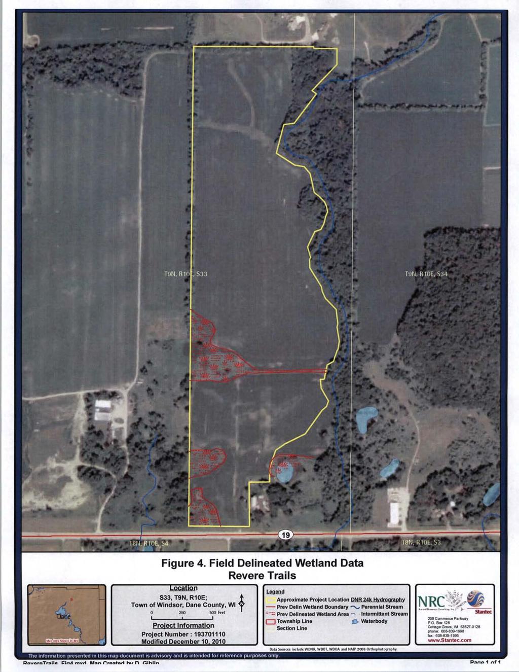
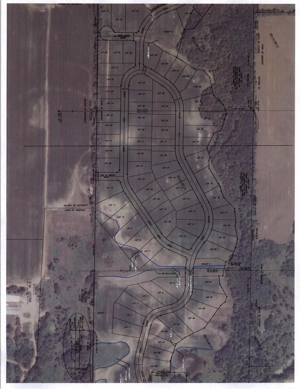
1 Dane County Planning & Development Land Division Review Date: June 26, 2012 To: Zoning & Land Regulation Committee From: Daniel Everson, Land Division Review Re: Revere Trails (preliminary plat) Town of Windsor, Section 33 (54 residential lots and 7 outlots, 73 acres) Review deadline August 19, 2012 Staff recommends the following conditions that will be applicable in approving the preliminary plat. Zoning 1. City of Sun Prairie Extraterritorial Zoning. Evidence of required zoning is to be established (publication in the official newspaper). Said publication is to include specific legal description. Dane County Comprehensive Plan 2. Compliance with the Dane County Comprehensive Plan is to be established. See Pam Andros, Senior Planner letter dated June 7, Before a subdivision plat may be recorded and filed for the same property, the condominium shall first be removed from the provisions of this chapter by recording a removal instrument. Currently, a recorded condominium, recorded as Document# , Dane County Registry. Platting of this land would violate S (1m)(b), Wisconsin Statutes. Dedication of Lands for public recreation within residential plats 4. The public park land appropriation requirement is to be satisfied (private park land does not satisfy this requirement). 5. All public land dedications are to be clearly designated dedicated to the public. 210 Martin Luther King Jr. Blvd. City-County Bldg, Room 116 Madison, WI Phone: Fax:
2 Land Suitability 6. Hydric soils are present see attached aerial map. Soil boring data from 2006 was submitted that determines elevation of ground water throughout the plat. 7. Lots 24 thru 37 fall within the shoreland zone. (Lands, which are within 300 from the OHWM of the unnamed perennial stream. Shoreland erosion control permits will be required from Land Conservation. 8. A notation is to be included that states: Lands covered by this plat are within an area subject to height limitations owing to the operation of aircraft and equipment from a nearby airport. Owners of lands within the area covered by this plat are required by law to restrict the height of trees, other vegetation and man-made structures to less than the height limitations set forth in that certain map dated April 24, 2008, entitled Height Limitation Zoning Map, Dane County Regional Truax Field, Madison, Wisconsin, said map being on file in the Dane County Clerk's office. 9. A notation is to be included that states: Lands covered by this plat are located within an area subject to heightened noise levels emanating from the operation of aircraft and equipment from a nearby airport. Design Standards 10. Staff discussed making all lots conform to the Shoreland requirement of 100-foot frontage without the need of special setbacks. It appears that Lots 31, 32, and 41 will have difficulties. 11. Staff expressed concerns regarding the size of the lots at a meeting with the developer on April 16, The developer's agent had expressed the willingness to increase the size to approximately 30,000 square feet. Lots 1 and 2, 6 to 13, 20 to 23, 26, 28, 34 to 43 and 49 to 50 appear to be less than that number. 12. Outlot 6 does not meet the lot width and area requirements with respect to the shorelandzoning district. Unsewered lots shall be not less than 100 feet in width at the building setback line and have an area of not less than 20,000 square feet. 13. Rezone petition #10449 to rezone 0.02 acres of wetlands to non-wetland district shall be approved. Previous rezone petition #10315 was denied by the County Board on September 1, A strip of wetlands less than 5 acres was previously delineated shown intersecting through the proposed Revere Pass highway right-of-way. Since then, 2-concrete culvert pipes were installed for the purpose of an agricultural crossing. This area would have to be rezoned out of the shoreland- wetland district and permits from DNR and Army Corps of Engineers. 210 Martin Luther King Jr. Blvd. City-County Bldg, Room 116 Madison, WI Phone: Fax:
3 14. Lots 1, 2 and 3 will have a reduced building envelope due to the setbacks from the wetland and the public highway right-of-way. Staff recommends showing a building envelope on the plat. 15. Lots 25, 26 and 27 will have a reduced building envelope due to the setbacks from the OHWM of the perennial stream and the public highway right-of-way. Staff recommends showing a building envelope on the plat. 16. Outlot 9 does not meet the public road frontage requirements with respect to Ch (6)(b). Every lot or parcel shall front or abut a public street. Conventional lots shall maintain a minimum frontage of 66-feet to facilitate the possible development of a public right-ofway that could serve additional lots. 17. It was the general consensus in the April 16th meeting that the east-west stormwater corridor located in the center of the subdivision should be an outlot rather than shown as an easement. There is an absence of an outlet in the center of the subdivision. Note that hydric soils are present in this area. 18. Per DCO 75.19(h), a minimum tangent length of 100 feet shall be used between reverse curves along FOREST PARK DRIVE and REVERE PASS. 19. Per DCO 75.19(i), streets shall be laid out so as to intersect as nearly as possible at right angles and in no case less than 75 degrees. This is even more important when intersecting another road on the inside of a curve. The Wisconsin Facilities Development Manual (FDM) specifies an intersection angle of no less than 80 degrees and no more than 100 degrees for low speed intersections on the inside of a curve with less than a 2000 foot radius. The best case scenario would be for LONGFELLOW COURT to intersect FOREST PARK DRIVE, radially, or near the tangent between curves. FDM reference attached. 20. If Outlot 8 is being dedicated for future roadway purposes, per Dane County Ordinance (DCO) 75.19(g), it shall be located across from the end of LONGFELLOW COURT or be offset a minimum of 150 feet. Due to the curvilinear layout of FOREST PARK DRIVE, a coterminous intersection would be desired. 21. A permanent or temporary cul-de-sac will be required at the west end of GREAT BRIDGE COURT and SON OF LIBERTY DRIVE, per DCO 75.19(q). 22. Street names with respect to Ch. 76 of the Dane County Code of Ordinances are to be assigned. Dane County Surveyor approval is to be obtained. 23. Utility easements are to be provided. 24. Village of DeForest corporate boundary lines are to be shown on the plat. 210 Martin Luther King Jr. Blvd. City-County Bldg, Room 116 Madison, WI Phone: Fax:
4 Required Improvements 25. Grading and surfacing. All streets shall be graded and surfaced in accordance with plans, specifications and requirements of the Dane County Highway Commission and the Town of Windsor. 26. Compliance with Ch DCCO, Erosion Control Plans is to be established. 27. Compliance with Ch DCCO, Stormwater Control Permits is to be established. 28. Street lights and street signs shall be provided in accordance with applicable town specifications. 29. The improvements shall be installed and approval of a final plat shall be given only after the work has been completed or there shall have been filed with the appropriate governmental jurisdiction or with the committee, one of the following: Surety bond in an amount sufficient to complete the work. Certified check in an amount sufficient to complete the work. Additional conditions 30. Town of Windsor approval is to be obtained. 31. Village of DeForest approval is to be obtained (extraterritorial jurisdiction). 32. State Highway 19 access approval shall be obtained and any comments or conditions from WisDOT are to be fulfilled. 210 Martin Luther King Jr. Blvd. City-County Bldg, Room 116 Madison, WI Phone: Fax:
266-4270, Rm. 362 Planning (608)266-4251, Rm. 116 Records & Support (608)266-4251, Rm.")


5 MEMORANDUM TO: FROM: Room 116, City-County Building, Madison, Wisconsin Fax (608) Zoning & Land Regulations (ZLR) Committee Pamela Andros, AICP, Senior Planner Housing & Economic Development (608) , Rm. 362 Planning (608) , Rm. 116 Records & Support (608) , Rm. 116 SUBJECT: Analysis of Revere Trails Preliminary Plat as it relates to Chapter 82 Subchapter II Dane County Comprehensive Planning, Town of Windsor, S33&34 Zoning (608) , Rm. 116 DATE: 06/7/2012 CC: Dan Everson, AZA & Plat Review Officer Roger Lane, Zoning Administrator Todd Violante, Director of Planning & Development Pam Dunphy, Public Works, Highways & Transportation Tina Butteris, Town of Windsor Clerk/Treasurer MHG Properties, LLC, Applicant As requested by the ZLR, staff provides analysis of subdivision plats comparing them against the local and county comprehensive plans. In this case, the analysis is of the consistency between the Revere Trails plat located in the Town of Windsor and the goals, objectives and policies of the Dane County Comprehensive Plan. The Dane County Comprehensive Plan describes broad policy directions for new development, but refers to component town and municipal plans for detailed land use, subdivision and public infrastructure recommendations relevant at the subdivision plat scale. This memo provides an update to the one provided last June. At that time the Revere Trails plat was a 62 (previously 83) residential lot subdivision with lots ranging from 20,000 to 30,000 square feet in size. Now the number of residential lots has been reduced to 54, and the range of lot sizes is now 25,000 to 40,000 square feet. During most recent meeting between the applicant, town and county staff, the county requested a minimum lot size of 30,000 square feet. The county-adopted Town of Windsor Comprehensive Plan: 2025 identifies the subject property in the Transition Residential land use district. The plan describes that future uses for this district include traditional single-family, detached neighborhoods including parks, schools and churches and on a limited basis, small-scale multi-family residential. The minimum lot size for this district is 12,000 square feet unless standards for Planned Residential Development (as outlined in the town subdivision code) are followed. It is also identified as being in Area 4 which is specified as Revere Trails. As part of the cooperative planning process with the Village of DeForest, the village agreed to amend their Future Land Use and Phasing Plans to coincide Dane County P&D, Revere Trails plat Page 1
6 with Town plans. The subject property is also shown, with general plat layout, in the Mixed Residential zoning district on the Sun Prairie-Windsor Joint Extraterritorial Zoning Map. The proposal is generally consistent with the component municipal plans, which both show the subject property in residential land use districts, but it should be noted that land suitability comes into play in all plans as they also contain natural resource protection elements. In addition to the analysis of component plans, other notable elements of the Dane County Comprehensive Plan include the Agricultural, Natural and Cultural Resources element (Chapter 5); the Land Use element (Chapter 8); and the Intergovernmental Cooperation element (Chapter 7). Under Water Resources, the comprehensive plan makes it clear that the county must continue to abide by the Dane County Water Quality Plan. The subject property is in close proximity to a wetland area associated with Pederson Spring that feeds into Token Creek. This tributary has been identified by the DNR as a spawning ground for brown trout. Protection of this resource is critical to achieve the wildlife resource goals of the Dane County Comprehensive plan. The applicant has removed all residential lots south of the strip of wetlands where hydric soils and wetlands are located. This is an improvement for addressing the above concerns. Another issue from previous submittals relates to nitrate levels. At that time, the applicant was asked to adequately demonstrate that proposed densities will not create nitrate groundwater pollution problems. Such information should show a comparison of nitrates associated with the current use to that of the proposed residential use. A key to this will be sanitary facilities and whether or not they will be adequate for the proposed configuration of lots. This concern goes back to the original proposal of over 80 lots, including lots located on land south of the strip of wetlands where hydric soils and wetlands are located. Removing those lots as well as decreasing the overall number of lots, thus decreasing overall density, alleviates concerns about nitrates to some degree. Regarding septic systems, the Public Health department states that the distribution component must be 50 from the ordinary high water mark. Everything else (tanks and pipes) can come within 10. The Dane County Comprehensive Plan uses Urban Service Areas (USA) as identified Smart Growth Areas. It should be noted that there is a recent Urban Service Area extension [Bear Tree] approved by DNR on 4/1/2011, located directly west of this property in the Village of DeForest. In order to meet intergovernmental cooperation goals, issues related to this proposal must be worked out between the town of Windsor and the Village of DeForest. Given the various joint planning efforts and agreements, it appears that intergovernmental issues are being addressed. I hope this information is helpful, and would be happy to answer any questions you may have. Please feel free to contact me at andros@countyofdane.com or if I can be of any further assistance. Dane County P&D, Revere Trails plat Page 2 of 2
7
8
9

10
11 DEFOREST AREA SCHOOL DISTRICT Revere Trails Town of Windsor, Section 33&34 Hydric Soils PC FARM HOLDINGS II LLC WINDSOR, TOWN OF STEVEN D PEDERSON LUKE A TITEL & ROBYN L TITEL st PEARL E KVALHEIM STEVEN D PEDERSON WINDSOR, TOWN OF DANE COUNTY WINDSOR, TOWN OF WILLIAM GRAFF Legend Hydric Inclusions All Hydric Æ 19 $
12
13
14
15
16
Dane County Planning & Development Land Division Review
 Dane County Planning & Development Land Division Review Date: July 17, 2012 To: Zoning & Land Regulation Committee From: Daniel Everson, Land Division Review Re: John Wilkinson Cropland (preliminary plat)
ARTICLE 23 CONDOMINIUM STANDARDS
 ARTICLE 23 CONDOMINIUM STANDARDS Section 23.01 Intent. The intent of this Article is to provide regulatory standards for condominiums and site condominiums similar to those required for projects developed
BYRON TOWNSHIP ZONING APPLICATION
 BYRON TOWNSHIP ZONING APPLICATION Phone: (616) 878-9104 * Fax: (616) 878-3980 * Website: www.byrontownship.org This application will not be accepted if incomplete. APPLICATION FOR & REQUIRED COPIES Private
ARTICLE 3 DEFINITIONS
 Sections: 3-1 Rules of Construction 3-2 Definitions ARTICLE 3 DEFINITIONS SECTION 3-1 RULES OF CONSTRUCTION 3-101. a. The language set forth in these regulations shall be interpreted in accordance with
610 LAND DIVISIONS AND PROPERTY LINE ADJUSTMENTS OUTSIDE A UGB
 ARTICLE VI: LAND DIVISIONS AND PROPERTY LINE ADJUSTMENTS VI-21 610 LAND DIVISIONS AND PROPERTY LINE ADJUSTMENTS OUTSIDE A UGB 610-1 Property Line Adjustments (Property Line Relocation) A property line
THE COUNTY BOARD OF SUPERVISORS OF THE COUNTY OF DOUGLAS DOES ORDAIN AS FOLLOWS:
 8.1 SUBDIVISION CONTROL ORDINANCE THE COUNTY BOARD OF SUPERVISORS OF THE COUNTY OF DOUGLAS DOES ORDAIN AS FOLLOWS: SECTION I. GENERAL INTERPRETATION This ordinance shall not repeal, impair or modify private
Department of Planning & Development Planning Unit
 Department of Planning & Development Planning Unit Website: www.cityofmadison.com Madison Municipal Building 215 Martin Luther King, Jr. Boulevard P.O. Box 2985 Madison, Wisconsin 53701-2985 TDD 608 266-4747
ARTICLE XVI SUBDIVISION DEVELOPMENT
 ARTICLE XVI SUBDIVISION DEVELOPMENT 16.0 The division of land into 4 or more lots that will require the construction or extension of public streets, water or sanitary sewerage (other than the direct connection
SECTION 4: PRELIMINARY PLAT
 SECTION 4: PRELIMINARY PLAT After the completion of the sketch plan process, if submitted, the owner or developer shall file with the City an application for preliminary plat. The preliminary plat stage
CHAPTER 18 SUBDIVISION AND PLATTING INTRODUCTION DEFINITIONS GENERAL PROVISIONS PROCEDURE PRELIMINARY PLAT
 CHAPTER 18 SUBDIVISION AND PLATTING 18.01 Statutory Authorization 18.02 Title 18.03 Purpose and Intent 18.04 Interpretation 18.05 Validity 18.06 Conflicting Ordinances 18.07 Effective Date 18.10 Definitions
Page 75-1 rev
 75.01 75.05 TITLE 14 PLANNING AND DEVELOPMENT Chapter 75 Land Division and Subdivision Regulations Chapter 76 Naming Roads and Numbering Buildings Chapter 78 Special Regulation of Structures and Trees
DAUPHIN CREEK ESTATES SUBDIVISION
 # 12 SUB-000076-2017 DAUPHIN CREEK ESTATES SUBDIVISION Engineering Comments: FINAL PLAT COMMENTS (should be addressed prior to submitting the FINAL PLAT for review and/or signature by the City Engineer):
Comprehensive Plan 2030
 Introduction The purpose of this chapter of the Comprehensive Plan is to accurately describe, in words and images, the goals and visions for the future of Clearfield, as determined by the people who live
Chapter 405 SUBDIVISION OF LAND. [HISTORY: Adopted by the Town Board of the Town of Middle Inlet Amendments noted where applicable.
 Chapter 405 SUBDIVISION OF LAND [HISTORY: Adopted by the Town Board of the Town of Middle Inlet 6-9-2005. Amendments noted where applicable.] Citations See Ch. 14. Planning Commission See Ch. 106. Driveways
TOWN OF ROME 1156 ALPINE DR. NEKOOSA, WI (715)
") TOWN OF ROME 1156 ALPINE DR. NEKOOSA, WI 54457 (715) 325-8012 For obtaining a Permit for SHEDS AND DECKS the following must be done before the Inspector can issue the permit: 1. County Zoning Permit -
TOWN OF ROME 1156 ALPINE DR. NEKOOSA, WI 54457 (715) 325-8012 For obtaining a Permit for SHEDS AND DECKS the following must be done before the Inspector can issue the permit: 1. County Zoning Permit -
Dane County Land Use Handbook
 Dane County Land Use Handbook Dane County Board of Supervisors Prepared by The Office of the County Board Last revision 4/6/98 Summary September 15, 1997 Dane County has land area of 1,202 square miles,
To provide for the review of the final engineering plans, the subdivision improvement agreement, public dedications, and other legal agreements.
 ARTICLE 5 FINAL PLAT 501 Intent DOUGLAS COUNTY SUBDIVISION RESOLUTION To provide for the review of the final engineering plans, the subdivision improvement agreement, public dedications, and other legal
Organized with a "core" curriculum (the first five modules) and "electives" (the remaining modules in the program.
 and electives (the remaining modules in the program.") Introduction Sponsored by The North Carolina Chapter - American Planning Association These materials are the result of an effort by volunteer members of the North Carolina Chapter of the American Planning
Introduction Sponsored by The North Carolina Chapter - American Planning Association These materials are the result of an effort by volunteer members of the North Carolina Chapter of the American Planning
** If your lot does not meet the requirements above, please read Sec below
 Sec. 13-1-60 Zoning District Dimensional Requirements. For the Zoning Dept To Issue a Land Use Permit The Following Dimensions are Required. Minimum Side and Rear Yards s Lakes Classification Minimum Class
POLK COUNTY CHAPTER 18 SUBDIVISION ORDINANCE
 POLK COUNTY CHAPTER 18 SUBDIVISION ORDINANCE Ordinance No. 13-17 Polk County Chapter 18 Subdivision Ordinance Enacted: March 21, 2017; Published: March 29, 2017 Effective Date: March 29, 2017 Polk County
The City Engineering Division has reviewed the subject development and has the following comments.
 DATE: April 11, 2007 TO: FROM: SUBJECT: Plan Commission Larry D. Nelson, P.E., City Engineer 5756 Portage Road Certified Survey Map The City Engineering Division has reviewed the subject development and
Condominium Unit Requirements.
 ARTICLE 19 CONDOMINIUM REGULATIONS Section 19.01 Purpose. The purpose of this Article is to regulate projects that divide real property under a contractual arrangement known as a condominium. New and conversion
Town of Prairie du Sac Sauk County, WI. Land Division Ordinance 07-3
 Town of Prairie du Sac Sauk County, WI Land Division Ordinance 07-3 1.01 DISCLAIMER (1) Multiple Jurisdictions. All persons reviewing the provisions of this Ordinance should be aware that the Town of Prairie
Preliminary Subdivision Application (Major) (Four (4) lots or more)
 (Four (4) lots or more)") Gunnison City Offices www.gunnisoncity.org 38 West Center Gunnison, Utah 84634 (435) 528 7969 Date of Application: Preliminary Subdivision Application (Major) (Four (4) lots or more) APPLICANT INFORMATION
Gunnison City Offices www.gunnisoncity.org 38 West Center Gunnison, Utah 84634 (435) 528 7969 Date of Application: Preliminary Subdivision Application (Major) (Four (4) lots or more) APPLICANT INFORMATION
LAND DIVISION AND SUBDIVISION CODE. Town of Springdale Dane County, Wisconsin
 1 2 3 4 5 6 7 8 9 10 11 12 13 14 15 16 17 18 19 20 21 22 23 24 25 26 27 28 29 30 31 32 33 34 35 36 37 38 39 40 41 42 43 44 45 46 Town of Springdale Dane County, Wisconsin Chapter 3. SUBCHAPTER 1 INTRODUCTION
MAJOR SUBDIVISION PRELIMINARY PLAT CHECKLIST
 TOWNSHIP OF EGG HARBOR PLANNING BOARD/ZONING BOARD OF ADJUSTMENT 3515 BARGAINTOWN ROAD EGG HARBOR TOWNSHIP, NJ 08234 MAJOR SUBDIVISION PRELIMINARY PLAT CHECKLIST The following checklist is designed to
City of Prior Lake APPLICATION FOR COMBINED PRELIMINARY AND FINAL PLAT
 Case File No. Property Identification No. City of Prior Lake APPLICATION FOR COMBINED PRELIMINARY AND FINAL PLAT Requested Action Brief description of proposed project (Please describe the proposed amendment,
ARTICLE 6 PRELIMINARY PLAT
 ARTICLE 6 PRELIMINARY PLAT SECTION: 30-06-01: Preliminary Plat 30-06-02: Information Required for Preliminary Plat 30-06-03: Determination of Requirement for Environmental Review Documents 30-06-04: Additional
Chapter 8 INTRODUCTION.2. STATE SUBDIVISION REGULATIONS 2 State Review (Objecting Authorities) Local Review (Approving Authorities) Basis for Approval
 Local Review (Approving Authorities) Basis for Approval") INTRODUCTION.2 STATE SUBDIVISION REGULATIONS 2 State Review (Objecting Authorities) Local Review (Approving Authorities) Basis for Approval LOCAL LAND DIVISION REGULATIONS 6 General Organization of a Subdivision
INTRODUCTION.2 STATE SUBDIVISION REGULATIONS 2 State Review (Objecting Authorities) Local Review (Approving Authorities) Basis for Approval LOCAL LAND DIVISION REGULATIONS 6 General Organization of a Subdivision
SUBDIVISION BY-LAW MUNICIPALITY OF THE COUNTY OF INVERNESS
 SUBDIVISION BY-LAW MUNICIPALITY OF THE COUNTY OF INVERNESS APPROVED BY COUNCIL: JUNE 15, 1998 EFFECTIVE DATE: SEPTEMBER 23, 1998 Page 2 TABLE OF CONTENTS PART 1: SHORT TITLE... 5 PART 2: INTERPRETATION...
Gates County Planning and Zoning
 Gates County Planning and Zoning PO Box 411, 200 Court Street, Gatesville, NC 27938 phone: 252-357-2411 fax: 252-357-0073 Application for Technical Review Committee For Staff Use Only: Date: Application
Township of Collier 2418 Hilltop Road Presto, PA 15142
 Township of Collier 2418 Hilltop Road Presto, PA 15142 Fees: Major: 2 checks $600 + $50 per lot & $1700 Escrow) APPLICATION FOR SUBDIVISION major FINAL only Plans must be folded Rolled plans will not be
CHAPTER 18 SITE CONDOMINIUM PROJECTS
 15.1800 CHAPTER 18 SITE CONDOMINIUM PROJECTS 15.1801 SECTION 18.01 PURPOSE AND SCOPE GRAND HAVEN CHARTER TOWNSHIP Site condominium projects are condominium developments in which each condominium unit consists
GENERAL CODE OF ORDINANCES FOR MARATHON COUNTY CHAPTER 18 LAND DIVISION and SURVEYING REGULATIONS. May 2016
 GENERAL CODE OF ORDINANCES FOR MARATHON COUNTY CHAPTER 18 LAND DIVISION and SURVEYING REGULATIONS www.co.marathon.wi.us May 2016 CHAPTER 18 LAND DIVISION AND SURVEYING (Rep. & Recr. #0-6-87) AUTHORITY
ELK RAPIDS TOWNSHIP ANTRIM COUNTY, MICHIGAN ORDINANCE NO
 ELK RAPIDS TOWNSHIP ANTRIM COUNTY, MICHIGAN ORDINANCE NO. 3-2011 AN ORDINANCE TO REPLACE THE SUBDIVISION CONTROL ORDINANCE WITH A NEW SUBDIVISION DEVELOPMENT ORDINANCE, IN ACCORD WITH THE LAND DIVISION
The City Engineering Division has reviewed the subject development and has the following comments.
 DATE: January 15, 2008 TO: FROM: SUBJECT: Plan Commission Larry D. Nelson, P.E., City Engineer 5302 Voges Road Certified Survey Map The City Engineering Division has reviewed the subject development and
COUNTY OF ALBEMARLE APPLICATION FOR RURAL SUBDIVISION
 Page 1 APPLICATION FOR RURAL SUBDIVISION The term rural subdivision means a type of subdivision that is located in the rural areas which results in two or more lots for the purpose of transfer of ownership
CITY OF FERNDALE HEARING EXAMINER
 CITY OF FERNDALE HEARING EXAMINER RE: Planned Unit Development ) 16001-PUD Preliminary Plat ) 16018-SE Plat Variance ) 16002-VAR Application by ) ) MD General, L.L.C. ) FINDINGS OF FACT, Malloy Heights
Preliminary Subdivision Application (Minor) (Three (3) lots or less)
 (Three (3) lots or less)") Gunnison City Offices www.gunnisoncity.org 38 West Center Gunnison, Utah 84634 (435) 528 7969 Date of Application: Preliminary Subdivision Application (Minor) (Three (3) lots or less) APPLICANT INFORMATION
Gunnison City Offices www.gunnisoncity.org 38 West Center Gunnison, Utah 84634 (435) 528 7969 Date of Application: Preliminary Subdivision Application (Minor) (Three (3) lots or less) APPLICANT INFORMATION
A.3. ARTICLE 7 PLAN REQUIREMENTS FOR MINOR SUBDIVISION AND/OR LAND DEVELOPMENT
 700. 701.A.3. ARTICLE 7 PLAN REQUIREMENTS FOR MINOR SUBDIVISION AND/OR LAND DEVELOPMENT SECTION 700 PURPOSE The purpose of this Article is to set forth a streamlined set of Plan Requirements for minor
APPLICATION FOR SUBDIVISION APPROVAL OF A SKETCH PLAN with checklist
 Prior to filing any application for SUBDIVISION approval, the applicant shall request in writing that the zoning administrator schedule a pre-submission conference. APPLICATION TO THE PLANNING BOARD TOWN
APPLICATION for MINOR SUBDIVISION REVIEW for CONCEPT and FINAL PLAT within COALVILLE CITY. Project Name: Project Address or Area: Name of Owner:
 APPLICATION for MINOR SUBDIVISION REVIEW for CONCEPT and FINAL PLAT within COALVILLE CITY For Office Use Only: Application #: Application Date: PC Approval Date: CC Approval Date: Community Development
Staff Report: Date: Applicant: Property Identification: Acreage of Request: Current Zoning of Requested Area: Requested Action: Attached:
 Staff Report: Completed by Jeff Palmer Director of Planning & Zoning Date: November 7, 2018 Applicant: Greg Smith, Oberer Land Developer agent for Ronald Montgomery ET AL Property Identification: Frontage
CHAPTER 14: DRIVEWAYS, TOWN HIGHWAYS, AND PRIVATE ROADS
 CHAPTER 14: DRIVEWAYS, TOWN HIGHWAYS, AND PRIVATE ROADS TABLE OF CONTENTS CHAPTER 14: PRIVATE DRIVEWAYS, TOWN HIGHWAYS AND PRIVATE ROADS 14-1 14.0100 AUTHORITY... 14-1 14.0200 TITLE... 14-1 14.0300 REGULATION
Ordinance No. AN ORDINANCE CREATING CHAPTER OF THE CODE OF ORDINANCES, THE TOWN OF DELLONA, SAUK COUNTY, WISCONSIN
 Ordinance No. AN ORDINANCE CREATING CHAPTER 10.01 OF THE CODE OF ORDINANCES, THE TOWN OF DELLONA, SAUK COUNTY, WISCONSIN The Town Board of the Town of Dellona, Sauk County, Wisconsin does ordain as follows:
PURPOSE AND BACKGROUND
 To: City of Manitowoc From: Mike Slavney and Jessica Schmiedicke, planning consultants Date: November 2, 2009 Re: Extraterritorial, Annexation and Intergovernmental Policies PURPOSE AND BACKGROUND The
TOWN OF LEWISTON PLANNING BOARD APPLICATION
 TOWN OF LEWISTON PLANNING BOARD APPLICATION DESCRIPTION OF PROPOSED REQUEST: Name of Property Owner: Phone #: Name of Applicant:Phone #: Address or Location of Proposal:_SBL# Size of Parcel or Structure:Existing
Certified Survey Map (CSM) Submittal Updated: 6/29/18
 Submittal Updated: 6/29/18") Certified Survey Map (CSM) Submittal Updated: 6/29/18 Town of Middleton 7555 W. Old Sauk Road Verona, WI 53593-9700 Phone: 608-833-5887 Fax: 608-833-8996 info@town.middleton.wi.us The Town of Middleton
Certified Survey Map (CSM) Submittal Updated: 6/29/18 Town of Middleton 7555 W. Old Sauk Road Verona, WI 53593-9700 Phone: 608-833-5887 Fax: 608-833-8996 info@town.middleton.wi.us The Town of Middleton
Survey and Recording Requirements
 Article C: Sec. 14-1-40 Survey and Recording Requirements Survey Requirements. (a) (b) (c) Prior to the final approval of land divisions to which this Chapter applies, the owner of the land shall have
HERON LANDING SUBDIVISION
 HERON LANDING SUBDIVISION Engineering Comments: Per FEMA guidelines, any development greater than 5 acres in size or subdivision 50 lots in size, requires a flood study. Width of drainage easement to be
NOTICE OF STATE MANDATED FEE! Approx. = $900 per Acre to Rezone A-1 Land
 NOTICE OF STATE MANDATED FEE! Approx. = $900 per Acre to Rezone A-1 Land STATE OF WISCONSIN MANDATED FARMLAND PRESERVATION ZONE DISTRICT REZONE CONVERSION FEE Beginning January 1, 2010, the State of Wisconsin
MINOR & MAJOR SUBDIVISION APPLICATION
 TOW OF HOOKSETT APPLICATIO # DATE MIOR & MAJOR SUBDIVISIO APPLICATIO Application for: Completeness Map and Lot o. Public Hearing o. of Lots LOCATIO: (Specify Street Address) OWER: APPLICAT: ADDRESS: ADDRESS:
Staff Report: Date: Applicant: Property Identification: Acreage of Request: Current Zoning of Requested Area: Requested Action: Attached:
 Staff Report: Completed by Jeff Palmer Director of Planning & Zoning Date: November 7, 2018, Updated November 20, 2018 Applicant: Greg Smith, Oberer Land Developer agent for Ronald Montgomery ET AL Property
SUBDIVISION APPLICATION CHECKLIST SKETCH PLAN PRELIMINARY PLAT FINAL PLAT
 RECEIVED STAMP SUBDIVISION APPLICATION CHECKLIST SKETCH PLAN PRELIMINARY PLAT FINAL PLAT A checklist of background information and submission requirements for processing of a sketch plan, preliminary plat
c) Stub streets shall be required as follows:
 Stub streets shall be required as follows:") Sec. 7.2.1 / Streets 7.2 DESIGN STANDARDS 7.2.1 Streets A) Interconnectivity 1) Conformity with Apex Transportation Plan. The subdivision s street system shall conform to the Apex Transportation Plan.
Sec. 7.2.1 / Streets 7.2 DESIGN STANDARDS 7.2.1 Streets A) Interconnectivity 1) Conformity with Apex Transportation Plan. The subdivision s street system shall conform to the Apex Transportation Plan.
Planning Department Oconee County, Georgia
 Planning Department Oconee County, Georgia STAFF REPORT REZONE CASE #: 6985 DATE: October 31, 2016 STAFF REPORT BY: Andrew C. Stern, Planner APPLICANT NAME: Williams & Associates, Land Planners PC PROPERTY
Initial Subdivision Applications Shall Include the Following:
 Initial Subdivision Applications Shall Include the Following: 1) Subdivision Application Form: completely filled out (12 copies) 2) Plat: The Plat must adhere to the requirements set forth in the Town
ARTICLE 24 PRIVATE ROAD, SHARED PRIVATE DRIVEWAY AND ACCESS EASEMENT STANDARDS
 ARTICLE 24 PRIVATE ROAD, SHARED PRIVATE DRIVEWAY AND ACCESS EASEMENT STANDARDS SECTION 24.00 INTENT AND PURPOSE The standards of this Article provide for the design, construction and maintenance of private
City of Prior Lake APPLICATION FOR REGISTERED LAND SURVEY
 Case File No. Property Identification No. City of Prior Lake APPLICATION FOR REGISTERED LAND SURVEY Requested Action Brief description of proposed project (Please describe the proposed amendment, project,
TOWN OF NORTHWOOD, NEW HAMPSHIRE
 TOWN OF NORTHWOOD, NEW HAMPSHIRE OFFICE OF THE PLANNING BOARD 818 First New Hampshire Turnpike, Northwood NH 03261 (603)942-5586 Extension 205 Facsimile: (603)942-9107 Major Subdivision Application Form
ZONING & LAND USE APPLICATION
 City of Maple Plain 5050 Independence St P.O. Box 97 Maple Plain, MN 55359 Office: (763) 479-0515 Fax: (763) 479-0519 ZONING & LAND USE APPLICATION APPLICANT INFORMATION Applicant Name Company, if applicable
ARTICLE 15. RULES, REGULATIONS AND DEFINITIONS
 ARTICLE 15. RULES, REGULATIONS AND DEFINITIONS Section 1. Interpretation and Construction: The following rules and regulations regarding interpretation and construction of the Ulysses-Grant County, Kansas,
ARTICLE 13 CONDOMINIUM REGULATIONS
 ARTICLE 13 CONDOMINIUM REGULATIONS Section 13.01 Purpose. The purpose of this Article is to regulate projects that divide real property under a contractual arrangement known as a condominium. New and conversion
SITE CONDOMINIUMS OR CONDOMINIUM SUBDIVISIONS
 Article XX SITE CONDOMINIUMS OR CONDOMINIUM SUBDIVISIONS 20.0 PURPOSE The purpose of this Section is to set forth the standards for review of the site condominiums or condominium subdivisions in all Zoning
Plans shall be drawn at a readable scale, signed, and sealed by a Florida Registered Engineer. The application package shall include:
 CHAPTER 400. SECTION 403. PERMIT TYPES AND APPLICATIONS SITE DEVELOPMENT 403.3. Preliminary Site Plans (PSP) A. Intent and Purpose PSPs are used to identify existing site conditions and demonstrate general
CHAPTER 18 SUBDIVISION AND PLATTING ORDINANCE OF THE TOWN OF OSCEOLA CODE OF ORDINANCES
 TOWN OF OSCEOLA POLK COUNTY WISCONSIN ORDINANCE # 18-03-03 CHAPTER 18 SUBDIVISION AND PLATTING ORDINANCE OF THE TOWN OF OSCEOLA CODE OF ORDINANCES 18.01 Purpose Adopted 3/08/99, Amended 5/12/03, 7/9/07,
ARTICLE VI. SUBDIVISION STANDARDS, PUBLIC
 ARTICLE VI. SUBDIVISION STANDARDS, PUBLIC IMPROVEMENTS, AND DESIGN REQUIREMENTS ARTICLE VI. SUBDIVISION STANDARDS, PUBLIC IMPROVEMENTS, AND DESIGN REQUIREMENTS DIVISION 1. GENERAL PROVISIONS Sec. 21-6100.
CONDITIONAL USE PERMIT (CUP)
") CONDITIONAL USE PERMIT (CUP) LAND DEVELOPMENT APPLICATION FORM DEPARTMENT OF PLANNING 300 East Main Street, Sun Prairie, WI 53590-2227 (608)825-1107 FAX (608)825-1194 Applications will not be processed
CONDITIONAL USE PERMIT (CUP) LAND DEVELOPMENT APPLICATION FORM DEPARTMENT OF PLANNING 300 East Main Street, Sun Prairie, WI 53590-2227 (608)825-1107 FAX (608)825-1194 Applications will not be processed
Hello Plat Review, I have a question.
 Hello Plat Review, I have a question. January 24, 2018 2018 Surveyors' Institute 1 When do I have to do a subdivision plat? January 24, 2018 2018 Surveyors' Institute 2 236.02 (12) Definitions. Requires
CITY OF HOBBS ORDINANCE NO..
 CITY OF HOBBS ORDINANCE NO.. AN ORDINANCE TO AMEND TITLE 16 OF THE HOBBS MUNICIPAL CODE IN ITS ENTIRETY. BE IT ORDAINED BY THE GOVERNING BODY OF THE CITY OF HOBBS, NEW MEXICO, that the following Chapter
City of Suwanee Development Regulations ARTICLE 10 PLAN AND PLAT SPECIFICATIONS
 ARTICLE 10 PLAN AND PLAT SPECIFICATIONS 10.1 CONCEPT PLAN SPECIFICATIONS The following paragraphs outline the required elements of both the required and optional plans and plats mentioned throughout these
Chapter 22 LAND USE* Article III. Subdivisions
 Chapter 22 LAND USE* Article III. Subdivisions Sec. 22-256. Authority to Regulate. Sec. 22-257. Scope; plat required. Sec. 22-258. Definitions. Sec. 22-259. Interpretations and Meanings. Sec. 22-260. Procedure
Developer Agreements: Protecting Town Infrastructure through Collaboration
 Developer Agreements: Protecting Town Infrastructure through Collaboration The Basics Developer agreement is an enforceable contract Can be used in many situations Is used to help build and protect town
-MENDOCINO COUNTY PLANNING AND BUILDING SERVICES- DIVISION OF LAND REGULATIONS TITLE 17
 ARTICLE VI -- GENERAL REGULATIONS AND PROVISIONS Sec. 17-50. Sec. 17-51 General Plan. Sec. 17-52 Lot and Block Design and Configuration. Sec. 17-53 Lot Access. Sec. 17-54 Private Roads. Sec. 17-55 Water
I. Requirements for All Applications. C D W
 108-16.1. Application checklists. Checklist for Required Submissions to the Planning Board or Zoning Board of Adjustment of Monroe Township All required submissions are to be made to the Administrative
SECTION 2. PROCEDURES FOR FILING AND REVIEW
 SECTION 2. PROCEDURES FOR FILING AND REVIEW Subdivision 2.01 Sketch Plan 2.02 Preliminary Plat 2.03 Final Plat 2.04 Certification Required 2.05 Denial of Plat 2.06 Administrative Subdivision 2.01 SKETCH
APPLICATION SUBMITTAL REQUIREMENTS FOR Tentative Parcel or Subdivision Maps
 CITY OF EL CERRITO Community Development Department Planning and Building Division 10890 San Pablo Avenue, El Cerrito, CA 94530 (510) 215-4330 FA (510) 233-5401 planning@ci.el-cerrito.ca.us APPLICATION
SUBDIVISION CODE CITY OF FORT ATKINSON
 SUBDIVISION CODE CITY OF FORT ATKINSON Adopted September 7, 1993 Amended July 21, 2015 Section 26.09 (D)(8) Storm Sewer Systems amended by Council on 09-03-96. Section 26.08(B)(1)(a),(b) and (c) Land Dedications
Section Preliminary Plat Checklist and Application Forms
 Section 201 - Preliminary Plat Checklist and Application Forms PRELIMINARY SUBDIVISION PLAT REVIEW PROCESS CHART PRELIMINARY SUBDIVISION PLAT APPLICATION PRELIMINARY PLAT REVIEW CHECKLIST CITY OF NAMPA
CHAPTER 5. Subdivisions Regulations
 CHAPTER 5 Subdivisions Regulations 10-5-1 Introduction and Purpose 10-5-2 Definitions 10-5-3 General Provisions 10-5-4 Procedure for Submitting Subdivisions 10-5-5 Design Standards; Streets and Lots 10-5-6
MUNICIPALITY OF THE DISTRICT OF CLARE SUBDIVISION BY-LAW
 MUNICIPALITY OF THE DISTRICT OF CLARE SUBDIVISION BY-LAW 1 Table of Contents PART 1 - TITLE... 4 PART 2 - INTERPRETATION... 4 PART 3 - DEFINITIONS... 4 PART 4 - PROCEDURE FOR APPROVAL OF PLANS OR INSTRUMENTS
PLAINFIELD CHARTER TOWNSHIP COMMUNITY DEVELOPMENT DEPARTMENT PLANNING, ZONING & BUILDING SERVICES MEMORANDUM
 PLAINFIELD CHARTER TOWNSHIP COMMUNITY DEVELOPMENT DEPARTMENT PLANNING, ZONING & BUILDING SERVICES 6161 BELMONT AVENUE N.E. BELMONT, MI 49306 PHONE 616-364-1190 FAX: 616-364-1170 www.plainfieldchartertwp.org
Hello Plat Review, I have a question.
 Hello Plat Review, I have a question. January 23, 2019 2019 Surveyors' Institute 1 1 A question came up at a town board meeting last night. I m doing 2 lots west of the road. Then I m doing 2, one lot
WESTON COUNTY FINAL PLAT APPLICATION
 WESTON COUNTY FINAL PLAT APPLICATION Property Owner: Mailing Address of owner: Telephone Number(s) of owner: Property Owner: Mailing Address of owner: Telephone Number(s) of owner: (If subdivider/applicant
AGENDA STATEMENT NO BUSINESS OF THE PLANNING COMMISSION City of Victoria, Minnesota STAFF REPORT. Casco Ventures (Developer)
") AGENDA STATEMENT NO. 17-1 BUSINESS OF THE PLANNING COMMISSION City of Victoria, Minnesota STAFF REPORT TO: Planning Commission PREPARED BY: Erin Smith, Senior Planner RE: Waterford Landing Project Rezoning
AGENDA STATEMENT NO. 17-1 BUSINESS OF THE PLANNING COMMISSION City of Victoria, Minnesota STAFF REPORT TO: Planning Commission PREPARED BY: Erin Smith, Senior Planner RE: Waterford Landing Project Rezoning
WESTMINSTER PARK SUBDIVISION
 WESTMINSTER PARK SUBDIVISION Engineering Comments: FINAL PLAT COMMENTS (should be addressed prior to submitting the FINAL PLAT for review and/or signature by the City Engineer): A. Provide all of the required
Instructions to the Applicant
 CONDITIONAL USE PERMIT APPLICATION Lake of the Woods County Land and Water Planning Office 206 8 th Avenue Southeast, Suite #290 Baudette MN 56623-2867 www.co.lake-of-the-woods.mn.us Phone: (218) 634-1945
DATE: February 22, 2018 All Proposers RFP# CTH M Design FROM: Pete Patten, Purchasing Agent SUBJECT: ADDENDUM #1 to RFP# CTH M Design
 GREG BROCKMEYER Director of Administration COUNTY OF DANE DEPARTMENT OF ADMINISTRATION PURCHASING DIVISION Room 425 City-County Building 210 Martin Luther King Jr. Blvd. Madison, WI 53703-3345 608-266-4131
Town of Cary, North Carolina Rezoning Staff Report 14-REZ-20 Habitat for Humanity Evans Road Town Council Meeting October 16, 2014
 Town of Cary, North Carolina Rezoning Staff Report 14-REZ-20 Habitat for Humanity Evans Road Town Council Meeting October 16, 2014 REQUEST To amend the Town of Cary Official Zoning Map by rezoning 0.53
Community Development Department 333 Broadalbin Street SW, P.O. Box 490 Albany, OR 97321
 SUMMARY Community Development Department 333 Broadalbin Street SW, P.O. Box 490 Albany, OR 97321 STAFF REPORT Application for Tentative Partition Plat Review Planning File PA-06-17 Phone: 541-917-7550
Memorandum To: From: CC: Date: Re:
 Memorandum To: Paul Singer From: Craig M. Bonenberger, SEO/ Jason P. Shaner, PE CC: File 090026 Date: 4/20/2009 Re: 1550 Pottstown Pike Feasibility Study The site under investigation is an 18 acre tract
A. Preserve natural resources as identified in the Comprehensive Plan.
 1370.08 Conservation Residential Overlay District. Subd. 1 Findings. The City finds that the lands and resources within the Conservation Residential Overlay District are a unique and valuable resource
ZONING & LAND REGULATION COMMITTEE Dane County Board Of Supervisors MINUTES OF THE MAY 9, 2006 WORK MEETING
 ZLR Committee Work Meeting Agenda Page 1 of 7 NOTE: These minutes reflect the notes of the recorder and are subject to correction and approval at a subsequent meeting of the Committee. ZONING & LAND REGULATION
ARTICLE 5 GENERAL REQUIREMENTS
 5.1 SUITABILITY OF THE LAND ARTICLE 5 GENERAL REQUIREMENTS 5.1.1 Land subject to flooding, improper drainage or erosion, and land deemed to be unsuitable for development due to steep slope, unsuitable
APPLICATION PROCEDURE
 ANTRIM PLANNING BOARD P. O. Box 517 Antrim, New Hampshire 03440 Phone: 603-588-6785 FAX: 603-588-2969 APPLICATION FORM AND CHECKLIST FOR MINOR OR MAJOR SITE PLAN REVIEW File Date Received By APPLICATION
County of Loudoun. Department of Planning MEMORANDUM
 County of Loudoun Department of Planning MEMORANDUM DATE: September 3, 2013 TO: FROM: Marchant Schneider, Project Manager Land Use Review Marie Genovese, AICP, Planner III, Community Planning SUBJECT:
CHAPTER FINAL AND PARCEL MAPS
 CHAPTER 19.48 FINAL AND PARCEL MAPS Section Page 19.48.010 General... IV-25 19.48.020 Phasing... IV-25 19.48.030 Survey Required... IV-26 19.49.040 Form... IV-26 19.48.050 Contents... IV-27 19.48.060 Preliminary
CHAPTER 10 Planned Unit Development Zoning Districts
 CHAPTER 10 Planned Unit Development Zoning Districts Section 10.1 Intent and Purpose The Planned Unit Development (PUD) districts are intended to offer design flexibility for projects that further the
Tentative Map Application Review Procedures
 FOR REFERENCE ONLY This page is not part of the application. Tentative Map Application Review Procedures The tentative map process in Churchill County is designed to provide a mechanism in order to divide
MAPLETON CITY CORPORATION. Step 7: Upon final approval and prior to plat recording the applicant shall provide the following:
 MAPLETON CITY CORPORATION Subdivision Process The City s subdivision requirements are designed to facilitate orderly, safe and efficient development and to implement the adopted General Plan. Below is