DANE COUNTY BOARD OF SUPERVISORS
|
|
|
- Damian Cooper
- 6 years ago
- Views:
Transcription
1 ZLR Committee Public Hearing Agenda Page 1 of 3 December 17, 2013 DANE COUNTY BOARD OF SUPERVISORS ZONING & LAND REGULATION COMMITTEE PUBLIC HEARING AGENDA Date: Tuesday, December 17, 2013 Time: 7:00 P.M. Location: ROOM 201, City-County Building, 210 MLK Jr. Boulevard, Madison NOTE: If you need an interpreter, translator, materials in alternate formats or other accommodations to access this service, activity or program, please call the phone number below at least three business days prior to the meeting. NOTA: Si necesita un intérprete, un traductor, materiales en formatos alternativos u otros arreglos para acceder a este servicio, actividad o programa, comuníquese al número de teléfono que figura a continuación tres días hábiles como mínimo antes de la reunión. LUS CIM: Yog hais tias koj xav tau ib tug neeg txhais lus, ib tug neeg txhais ntawv, cov ntawv ua lwm hom ntawv los sis lwm cov kev pab kom siv tau cov kev pab, cov kev ua ub no (activity) los sis qhov kev pab cuam, thov hu rau tus xov tooj hauv qab yam tsawg peb hnub ua hauj lwm ua ntej yuav tuaj sib tham. Contact Information: Zoning Office, Planning & Development Department, , or WI Relay (711) I. CALL TO ORDER II. PUBLIC COMMENT ITEMS TO BE CONSIDERED III. PUBLIC HEARING FOR ZONING MAP AMENDMENTS, CONDITIONAL USE PERMIT APPLICATIONS, RESOLUTIONS, AND ORDINANCE AMENDMENTS 1. PETITION: REZONE APPLICANT: STEVEN G NAMPEL LOCATION: NORTH OF 4758 JACOBS ROAD, SECTION 36, TOWN OF MEDINA CHANGE FROM: A-1EX Agriculture District TO A-2 (1) Agriculture District REASON: creation of one residential lot 2. PETITION: REZONE APPLICANT: KLEIN FAMILY FARM LLC LOCATION: 1584 SAND HILL ROAD, SECTION 6, TOWN OF RUTLAND CHANGE FROM: A-1EX Agriculture District TO RH-1 Rural Homes District REASON: separation of existing residence from farmland 3. PETITION: REZONE APPLICANT: ANDREW J JUDD LOCATION: NORTH OF 9571 OVERLAND ROAD, SECTION 1, TOWN OF PERRY CHANGE FROM: A-B Ag-Business District TO C-1 Commercial District and A-1EX Agriculture District TO RH-1 Rural Homes District REASON: allow woodworking facility and sawmill
2 ZLR Committee Public Hearing Agenda Page 2 of 3 December 17, PETITION: REZONE APPLICANT: BARRETT J CORNEILLE LOCATION: 1842 S QUAM DRIVE, SECTION 36, TOWN OF DUNN CHANGE FROM: R-3 Residence District TO RH-1 Rural Homes District, A-1EX Agriculture District TO A-4 Agriculture District and RH-1 Rural Homes District REASON: creation of two lots for rural homes and one agricultural lot 5. PETITION: REZONE APPLICANT: JANETH M BOESE LOCATION: 6904 PAPE ROAD, SECTION 27, TOWN OF ROXBURY CHANGE FROM: C-2 Commercial District TO C-2 Commercial District REASON: amend restrictions to allow vehicle repair and sales 6. PETITION: REZONE APPLICANT: ZIEGLER TR, MARIE L REV TR LOCATION: 6878 SCHNEIDER ROAD, NORTH SIDE OF SCHNEIDER ROAD, SECTION 34, TOWN OF SPRINGFIELD CHANGE FROM: A-1EX Agriculture District TO A-2 (2) Agriculture District REASON: separation of existing residence from farmland 7. PETITION: REZONE APPLICANT: TOWN OF ROXBURY LOCATION: VARIOUS SECTIONS, TOWN OF ROXBURY CHANGE FROM: A-1EX Agriculture District TO VARIOUS DISTRICTS REASON: allow implementation of the Dane County Farmland Preservation Plan for the Town of Roxbury for various properties located in the Town of Roxbury. For a detailed listing of properties and zoning, visit the following website: under the title Town of Roxbury Blanket Rezone (Rezone Petition 10624), or contact Dane County Zoning Division at (608) ORDINANCE AMENDMENT 24, : Amending Chapter 82 of the Dane County Code of Ordinances, Incorporating the Town of Springdale Comprehensive Plan into the Dane County Comprehensive Plan. IV. PETITIONS REREFFERED FROM THE DECEMBER 5, 2013 COUNTY BOARD MEETING 1. PETITION: REZONE and CUP 2254 APPLICANT: DENNIS E BALLWEG LOCATION: 6790 TWIN LANE ROAD, SECTION 25, TOWN OF BRISTOL CHANGE FROM: A-1 Agriculture District TO A-3 Agriculture District REASON: to allow a small scale electric generating station CUP DESCRIPTION: small scale electric generating station V. AGENDA ITEMS FROM PREVIOUS MEETINGS 1. PETITION: REZONE APPLICANT: DENNIS R KIRCH LOCATION: 6612 SHOWER ROAD, SECTION 36, TOWN OF MAZOMANIE CHANGE FROM: A-1EX Agriculture District TO A-2 Agriculture District REASON: zoning compliance for structures 2. PETITION: CUP 2253 APPLICANT: REINDAHL STONE INC LOCATION: 783 COUNTY HIGHWAY MM, SECTION 24, TOWN OF OREGON CUP DESCRIPTION: 150' monopole communication tower VI. PLATS AND CERTIFIED SURVEY MAP 1. PRELIMINARY PLATS None
3 ZLR Committee Public Hearing Agenda Page 3 of 3 December 17, FINAL PLATS None 3. CERTIFIED SURVEY MAPS None VII. RESOLUTIONS VIII. ORDINANCE AMENDMENTS 1. ORDINANCE AMENDMENT 24, : Amending Chapter 82 of the Dane County Code of Ordinances, Incorporating the Town of Springdale Comprehensive Plan into the Dane County Comprehensive Plan. IX. OTHER BUSINESS AUTHORIZED BY LAW 1. Pending Zoning Map Amendments a. Petition 10486, Jon Larson, Section 3, Town of Blue Mounds b. Petition 10517, Orlin Groven, Section 25, Town of Albion c. Petition 10552, Parish (Paul Wilichowski), Section 19, Town of Black Earth d. Petition 10598, Michelle Schroeder, Section 6, Town of Windsor e. Petition 10599, Deppeler (Dan LeGros), Section 36, Town of Primrose f. Petition 10605, Debora Schweiss, Section 13, Town of Burke g. Petition 10616, JAD Development, Section 24, Town of Burke 2. Report of approved Certified Survey Maps a. APP # 9541, Baker, Town of Roxbury, Section 29/30 (2 lots, 5.3 acres) b. APP # 9539, Merrick Estate, Town of Medina, Section 23 (1 lot, 2.0 acres) c. APP # 9546, Tierney, Town of Bristol, Section 14 (1 lot, 6.3 acres) d. APP # 9554, Welsch, Town of Roxbury, Section 2 (1 lot, 0.47 acres) e. APP # 9552, Ripp, Town of Vienna, Section 17 (1 lot, 2.0 acres) X. ADJOURN Supervisor Patrick Miles, Chair, Zoning & Land Regulation Committee AGENDA POSTED: December 12, 2013
4

5 Staff Report Zoning and Land Regulation Committee Public Hearing: December 17, 2013 Petition: Rezone Zoning Amendment: Town/sect: A-1EX Exclusive Agriculture Medina District to A-2(1) Agriculture Section 36 District Acres:1.0 Survey Req. Yes Reason: Creating one residential lot Applicant Steven G Nampel Location: North of 4758 Jacobs Rd Description: The petitioner would like to create a residential lot on the 35-acre parcel. The housing density right appears to be stemming from a destroyed residence. Observations: Approximately 30% of the proposed lot is wooded. The grade ranges from 16% to 26% in the center portion of the lot. No other sensitive environmental features observed. There are multiple outbuildings on the 35-acre property. Some may be habitable. Note: Residential development must be located at least 200 feet away from the I-94 corridor per Noise Overlay District requirements. Town Plan: The property is located in the Agricultural Preservation Area. All residences count as a housing density right. The Town of Medina has sent a letter noting the history of the parcel. County Staff has reviewed the history of the parcel and determined a housing density right exists on the property. The Town Plan lists criteria for siting residential development. See attached excerpts from the Town Plan. Resource Protection Area: The Town of Medina Plan identifies lands within 100-year floodplains, wetlands, significant woodlands, and steep slopes exceeding 12% grade as being part of the resource protection area. Development should be discouraged in these areas. The majority of the proposed zoning boundary is within the resource protection area. Staff Comments: The proposal may be conflict with Town Plan policies regarding resource protection areas due to steep slope topography. Staff suggests that the home site be shifted further south to an area with lesser slopes. The remaining acreage will be less than 35 acres in size and will need to be included in the Certified Survey Map as a second lot with appropriate zoning such as A-4. Town Action: Pending.
6
7
8
9
10
11 Jacobs Rd Legend Steep Slopes <VALUE> Slopes < 12% Slopes < 20% 100-year Floodplain Feet Petition Nampel
12

13 Staff Report Zoning and Land Regulation Committee Public Hearing: December 17, 2013 Petition: Rezone Zoning Amendment: Town/sect: A-1EX Exclusive Agriculture Rutland District to RH-1 Rural Homes Section 06 District Acres:2.0 Survey Req. Yes Reason: Separation of existing residence Applicant Klein Family Farm LLC Location: 1584 Sand Hill Rd Description: The applicant would like to separate the existing farm house from the 400-acre farm. Observations: The entire property consists of Class I & II soils. There is an existing residence contained within the proposed lot. The 2009 floodplain is shown to be encroaching on the proposed lot. However, the 2013 FEMA floodplain maps show the floodplain greatly reduced to the banks of the Badfish Creek located approximately 700 feet away. No other sensitive environmental features observed. Town Plan: The property is located in the Agricultural Preservation Area. Resource Protection Area: The Town of Rutland Comprehensive Plan identifies wetlands, floodplains, recharge areas, and riparian habitat as part of the resource protection area. The proposal appears to be outside the resource protection area given the new flood studies performed by the DNR on the Badfish Creek as delineated on the preliminary 2013 FEMA floodplain maps. Staff Comments: The proposal meets the dimensional standards of the Zoning District. Town Action: PENDING
14
15
16 Sand Hill Rd Town of Dunn 2013 Preliminary Floodplain Boundary Town of Rutland Legend Significant Soils Steep Slopes 100-year Floodplain Feet Class Class 1 Class 2 <VALUE> Slopes < 12% Slopes < 20% Petition Klein Family

17 Staff Report Zoning and Land Regulation Committee Public Hearing: December 17, 2013 Petition: Rezone Zoning Amendment: Town/sect: A-B Agriculture Business to C-1 Perry Commercial District and A-1 EX Section 01 Exclusive Agriculture to RH-1 Rural Homes District Acres:2.0, 2.0 Survey Req. No Reason: Zoning compliance to allow a sawmill and woodworking shop and to create a residential home site Applicant Andrew J Judd Location: North of 9571 Overland Road Description: The applicant would like to construct a woodworking shop and a single-family residence on a 45-acre parcel. The business will produce custom cabinetry along with cutting wood for the cabinetry. Two zoning boundaries are requested for each land use. No land division is requested. Observations: The 45-acre property has rolling topography with some areas exceed 20% grade. There is an unnamed perennial stream and an intermittent stream on the east side of the property. The area surrounding the stream is in the floodplain. Class II soils are present on the east side of the property and along Overland Road. In 1988, a portion of the property was zoned to A-B Agri-Business to allow prairie seed production/nursery, but the business never evolved. The closest resident is 300 feet away from the proposed commercial area on the opposite side of Overland Road; other residents are 100 feet away. Town Plan: The property is located in the Agricultural Preservation Area. One housing density right remains on the original farm. The Perry Comprehensive Plan limits commercial activity to small businesses with limited outside storage. The proposed business must meet 10 mandatory criteria in order to be approved. Industrial uses and heavy commercial uses are strongly discouraged. See attached town plan language. Resource Protection Area: The Town of Perry Comprehensive Plan identifies prime agricultural land, wetlands, floodplains, shoreland, oak savannas, native prairies, and slopes in excess of 20% as area of resource protection. The proposed development is outside the mapped resource protection areas. Staff Comments: The RH-1 lot should maintain a minimum lot width of 66 feet in order to conform to land division requirements, however a spot zone is requested. The proposal shows 23 feet. Staff suggests deed restricting the C-1 Commercial Zoning area to the specific activities in order to conform to the Town s Land Use policies. In addition, a deed restriction should be placed on the remaining A-1 Exclusive land to prohibit further residential development due to housing density rights being exhausted on the original farm. Town Action: Approved conditioned upon limited land uses and prohibiting further residential development.

18
19 DCPREZ Regarding Petition # TOWN BOARD ACTION REPORT REZONE Dane County Zoning & Land Regulation Committee Public Hearing Date Perry 12/17/2013 Whereas, the Town Board of the Town of having considered said zoning petition, be it therefore resolved that said petition is hereby (check one): Approved Denied Postponed Town Planning Commission Vote: in favor opposed abstained Town Board Vote: 3 in favor 0 opposed 0 abstained THE PETITION IS SUBJECT TO THE FOLLOWING CONDITION(S) (Check all appropriate boxes): 1. Deed restriction limiting use(s) in the C-1 zoning district to only the following: Woodworking shop. Agricultural activity. 2. Deed restrict the balance of A-1 EX Agricultural Exclusive zoned land owned by the applicant from the original farm (as of date specified in the Town Plan) prohibiting non-farm development. Please provide property description, or tax parcel number(s): no density unit on remaining est. 54 acres. 3. Deed restrict the applicant's property described below prohibiting division. Please provide property description, or tax parcel number(s): 4. Condition that the applicant must record a Notice Document which states all residential development units (a.k.a. splits) have been exhausted on the property, and further residential development is prohibited under Town & County Land Use Planning policies. Please provide property description, or tax parcel number(s): 5. Other Condition(s). Please specify: Please note: The following space is reserved for comment by the minority voter(s), OR, for the Town to explain its approval if the decision does not comply with the relevant provisions of the Town Plan. Mary Price Perry 12/10/2013 Mary Price 12/11/2013 I,, as Town Clerk of the Town of, County of Dane, hereby certify that the above resolution was adopted in a lawful meeting of the Town Board on Town Clerk Date: (2/06) WEB
20
21
22
23
24
25
26
27
28
29
30 Town of Blue Mounds JG Town of Springdale Lewis Rd Overland Rd Town of Perry Town of Primrose Legend Significant Soils Steep Slopes 100-year Floodplain Feet Class Class 1 Class 2 <VALUE> Slopes < 12% Slopes < 20% Petition Judd

31 Staff Report Zoning and Land Regulation Committee Public Hearing: December 17, 2013 Petition: Rezone Zoning Amendment: Town/sect: A-1EX Exclusive Agriculture Dunn District to R-3 Residential Section 36 District, RH-3 Rural Homes District and A-4 Small Lot Agriculture District Acres: 3.0, 23, 8.5 Survey Req. Yes Reason: Creating two residential lots and one agriculture lot Applicant Barrett J Corneille Location: 1842 S Quam Drive Description: The petitioner would like to reconfigure the property boundaries of several parcels to create two residential lots and one agricultural lot. The lot with the existing house will be sold to a third party. Their plans are to remove and replace the house. Observations: The property is made up of 4 tax parcels which contain 3 distinct deeds of record. There is an existing residence on one of these parcels. A 1-acre section of land that contains the existing residence is within the Lake Kegonsa Limited Service Area and served by public sewer. A portion of the property is located within 1000 feet of Lake Kegonsa and subject to Shoreland regulations. 85% of the property consists of Class II soils. There is a small area on the proposed RH-1 lot (north) that has slopes exceeding 20% grade. The current use of the land is agricultural production. Town Plan: The property is located in the Agricultural Preservation Area and subject to the density policies of the Town Plan. As stated, the property consists of 3 deeds of record. However, given that 2 of the parcels were under contiguous ownership at the time of adopting A-1 Exclusive zoning, two housing density have been allotted to the property. Resource Protection Area: The Town of Dunn identifies prime soils, woodland areas, wetlands, steep slopes (15 percent or greater over 30 feet) as part of their resource protection area. The Town s Sensitive Environmental Feature Map identifies areas within the proposed RH-1 lot (north) being in the Resource Protection Area. Staff Comments: The proposal meets the dimensional standards of the zoning district. Staff suggests that slopes of 15% and greater should be shown on the certified survey map and development restricted in this area. Town Action: Approved conditioned upon a deed restriction being placed on Lot 2 (A-4) to prohibit residential housing and conditioned upon Town site plan approval for the development of Lot 3.

32
33
34
35
36
37 Lake Kegonsa Aalseth Ln Bjoin Dr Quam Dr Brooklyn Dr S Quam Dr Town of Dunn S Brooklyn Dr Giehler Dr 51 Legend Steep Slopes <VALUE> Slopes < 12% Slopes < 20% Resource Protection Corridors Feet Petition Corneille
38 HAROLD H WELLS JR BARRETT J CORNEILLE & JOHN R CORNEILLE RANDY A MALCOOK WI DNR WI DNR BARRETT J CORNEILLE ROBERT W BLINT Lake Kegonsa NORTH LIVING TR Town of Dunn BARRETT J CORNEILLE & JOHN R CORNEILLE DANA SPERLOEN & WENDY SPERLOEN Feet Resource Protection Area Scale 1" = 200' Legend

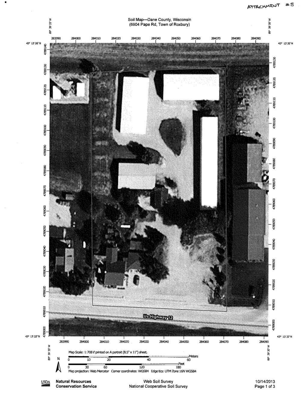
39 Staff Report Public Hearing: December 17, 2013 Petition: Rezone Zoning Amendment: Town/sect: C-2 Commercial District to C-2 Roxbury Commercial District Section 27 Zoning and Land Regulation Committee Acres:1.92 Survey Req. No Reason: Amend the deed restriction to allow for additional commercial uses. Applicant Janeth M Boese Location: 6904 Pape Rd Description: The applicant would like to expand the current deed restricted land uses on the property to allow for a broader array of uses in preparation of selling the property. Originally, the applicant was working with a perspective buyer that was interested in conducting auto sales, but that is no longer the case. The request would expand the uses to rooming and boarding houses, manufacturing facilities, major auto repairs, auto sales; and potentially motels, taverns, kennels, and car washes through a conditional use permit. The request includes a limit of 20 vehicles on the property at any one time. Observations: The property is located in an existing commercial area along a frontage road of State Highway 12. All neighboring uses are commercial in nature. There is an existing residence, a two-story retail building (inactive), and several mini-warehouse buildings currently on the lot. The entire area consists of Class II soils. No other sensitive environmental features observed. Town Plan: The Town Plan designates the area as Highway Crossroads. The purpose is to allow planned commercial development along major road-ways, particularly Hwy 12. Uncontrolled commercial development is discouraged. Resource Protection Area: The property is outside the resource protection area. Staff Comments: The proposal appears to be consistent with Town Plan Policies. Staff is concerned that future uncontrolled exterior lighting in this area may present a traffic hazard along Highway 12. If approved, staff suggests deed restricting the property to the suggested land uses, in addition, prohibiting billboard signs. The deed restriction should require future landowners to obtain site plan approval from the Town Board prior to any changes to the existing land uses. Town Action: Approved conditioned upon the limits on the suggested uses.
40
41
42
43
44
45
46
47
48
49
50 A-2(4) KP A-1(EX) A-1(EX) Town of Roxbury C-1 C-2 Pape Rd RH-1 12 A-1(EX) A-1(EX) RH-4 A-1(EX) Legend Significant Soils Class Class 1 Class 2 Resource Protection Corridors Feet Petition Boese

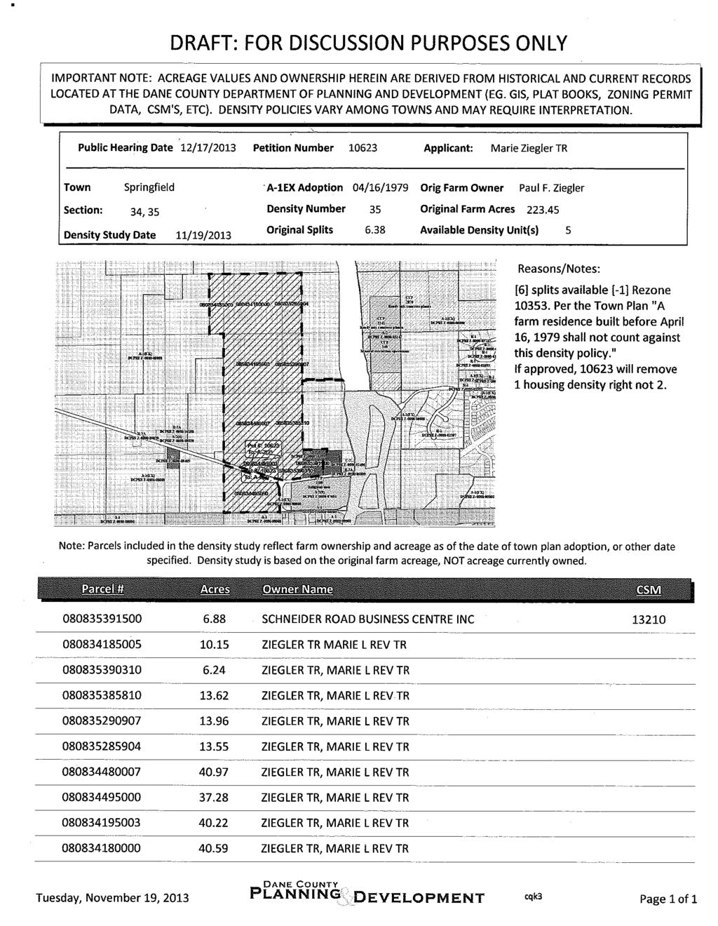
51 Staff Report Public Hearing: December 17, 2013 Petition: Rezone Zoning Amendment: Town/sect: A-1EX Exclusive Agriculture Springfield District to A-2(2) Agriculture Section 34 Zoning and Land Regulation Committee Acres:7.1 Survey Req. Yes Reason: Separation of existing residence Applicant Ziegler TR, Marie L REV TR Location: North of 6878 Schneider Road Description: The petitioner would like to separate the existing residence and outbuildings from the 120 acres of cropland, which will be sold to a third party. A lot is being created for each of the applicant s sons. The petitioner is requesting that the easterly lot be deed restricted to prohibit residential housing to preserve housing density rights. Observations: The farmstead consists of an existing farm residence and several outbuildings. One of the outbuildings is proposed to be located on a separate lot. The western area consists of Class II soils. There are slopes between 12% and 20% associated with a mound (hill) located on the eastern side of the proposed lots. Town Plan: The property is located in the Agricultural Preservation District. The Town Plan does not count the separation of the farm residence for the farmland. Five (5) housing density rights remain on the original farm. No increase in density is anticipated. Resource Protection Area: The Town of Springfield identifies prime soils, wetlands, floodplains, hydric soils, and slopes greater than 20% as part of the resource protection area. There a few minor spots on the proposed lots exceeding 20% grade. Staff Comments: The proposal meets the dimensional standards of the zoning district. As requested, a deed restriction should be placed on proposed Lot 2 to prohibit residential development. NOTE: The A-2(2) Zoning District limits livestock to 1 animal unit per acre. Town Action: Approved conditioned upon a shared driveway agreement and no residential development on the southeastern lot.
52 Regarding Petition # TOWN BOARD ACTION REPORT REZONE Dane County Zoning & Land Regulation Committee Public Hearing Date Springfield 12/17/2013 Whereas, the Town Board of the Town of having considered said zoning petition, be it therefore resolved that said petition is hereby (check one): Approved Denied Postponed Town Planning Commission Vote: in favor opposed abstained Town Board Vote: 5 in favor 0 opposed 0 abstained THE PETITION IS SUBJECT TO THE FOLLOWING CONDITION(S) (Check all appropriate boxes): 1. Deed restriction limiting use(s) in the zoning district to only the following: 2. Deed restrict the balance of A-1 EX Agricultural Exclusive zoned land owned by the applicant from the original farm (as of date specified in the Town Plan) prohibiting non-farm development. Please provide property description, or tax parcel number(s): 3. Deed restrict the applicant's property described below prohibiting division. Please provide property description, or tax parcel number(s): 4. Condition that the applicant must record a Notice Document which states all residential development units (a.k.a. splits) have been exhausted on the property, and further residential development is prohibited under Town & County Land Use Planning policies. Please provide property description, or tax parcel number(s): Motion (Endres/Gabrysiak) to approve CSM and rezone of Lot Motion by Plan Commission is 4.75 acres to A-2(2) and Lot acres to A-2(2) and remaining 31 acres to A-2 with a shared driveway/maintenance agreement and deed restrict Lot 2 that no residential home may be built on this lot. Motion carried, 5 0. Motion from Town Board is grant approval of the creation of 2 lots and separate farm house/buildings from agricultural land, Lot ac to A-2(2) and Lot to A-2(2) and remaining 31 ac to A-2 and CSM (Shared Driveway Permit) with the comments from the Plan Commission, the letter from David Ziegler and the driveway agreement. All ayes, carried. 5. Other Condition(s). Please specify: Please note: The following space is reserved for comment by the minority voter(s), OR, for the Town to explain its approval if the decision does not comply with the relevant provisions of the Town Plan. Carolyn Hacker Springfield 12/3/2013 Carolyn Hacker 12/11/2013 I,, as Town Clerk of the Town of, County of Dane, hereby certify that the above resolution was adopted in a lawful meeting of the Town Board on Town Clerk Date: (2/06) WEB
53
54
55
56 Schneider Rd Springton Dr Legend Significant Soils Class Class 1 Class 2 Steep Slopes <VALUE> Slopes < 12% Slopes < 20% Feet Petition Ziegler

57 Staff Report Public Hearing: December 17, 2013 Petition: Rezone Zoning Amendment: Town/sect: A-1EX Exclusive Agriculture Roxbury District to Various Districts Section 06 Zoning and Land Regulation Committee Acres: 45 Survey Req. No Reason: Zoning compliance for non conforming parcels Applicant Town of Roxbury Location: Town of Roxbury Blanket Rezone Process Town of Roxbury Staff met with the Town of Roxbury to discuss the concept of the Blanket Rezone and what it meant for the Town and the Landowners. The Town then scheduled a public meeting on October 15, 2013 at the Town Hall to help facilitate this Blanket Rezone and answer landowner questions. Affected landowners received a direct mailing notification. Farmland Preservation Plan Rezones (FPP) Required by DATCP, these rezones were identified because of location of certain parcels inside the Town of Roxbury Rural Development Area or the Roxbury Limited Service Area. There are a total of 24 land owners and 28 tax parcels affected; all land owners listed have had a chance to respond via phone, or at the Town meeting. Town Action The Town of Roxbury Board approved the final list on 10/21/2013. Staff If approved, the zoning in the Town of Roxbury will be consistent with the Dane County Farmland Preservation Plan and therefore eligible for the state Farmland Preservation Tax Credits.
58
59
60
61
62
266-4251, Rm. 116 Records & Support (608)266-4251, Rm. 116 Zoning (608)266-4266, Rm.")
63 TO: FROM: Room 116, City-County Building, Madison, Wisconsin Fax (608) County Board Supervisors County Executive Joe Parisi Town of Springdale Supervisors Town of Springdale Planning Commission All Other Interested Parties Brian Standing, Senior Planner Planning (608) , Rm. 116 Records & Support (608) , Rm. 116 Zoning (608) , Rm. 116 SUBJECT: County Board Ordinance Amendment #24, Town of Springdale Comprehensive Plan Amendment DATE: December 4, 2013 CC: Todd Violante, Director of Planning & Development Roger Lane, Zoning Administrator Karin Thurlow Petersen, County Board Staff This memo describes amendments to the Dane County Comprehensive Plan proposed by the Town of Springdale. Under intergovernmental cooperation policies of the Dane County Comprehensive Plan, town plans must be adopted by the county board and signed by the county executive before they can be used to make county zoning decisions. To assist county officials in their decision making, the Planning Division prepares written information describing any proposed town plan amendments. You may direct any questions to I. SUMMARY On May 20, 2013 the Town of Springdale Board of Supervisors adopted amendments to the Town of Springdale Comprehensive Plan. The Town Board has requested that the Dane County Board of Supervisors adopt the revised Town of Springdale Comprehensive Plan, in its entirety, as an amendment to the Dane County Comprehensive Plan. II. BACKGROUND A. Ordinance and Plan Amended: If adopted, Ordinance Amendment #24 would amend Chapter 82, Subchapter II of the Dane County Code of Ordinances to incorporate the Town of Springdale Comprehensive Plan as part of the Dane County Comprehensive Plan. B. Action required: The County Board and the County Executive must approve Ordinance Amendment #24 for it to become effective. Town comprehensive plans are adopted as part of the Dane County Comprehensive Plan under s (1)(d), Dane County Code and Intergovernmental Cooperation Policies for Town Governments (pp ) of the Dane County Comprehensive Plan. The Dane County Comprehensive Plan is adopted under Chapter 82, Subchapter II, Dane County Code, s , Wis. Stats, and s , Wis. Stats. C. ZLR public hearing: The Zoning and Land Regulation Committee (ZLR) advises the County Board on proposed Comprehensive Plan amendments. The ZLR Committee has scheduled a public hearing on Ordinance Amendment #24 for December 17, 2013.
64 D. Sponsors: Ordinance Amendment #24 was submitted by County Board Supervisor Downing on November 7, III. DESCRIPTION A. Ordinance Amendment #24 would amend the Dane County Comprehensive Plan by incorporating amendments to the Town of Springdale Comprehensive Plan, as adopted by the Town of Springdale Board of Supervisors on August 22, B. The amendments would make a number of minor amendments to the plan text to promote clarity and readability, including: Calculation of allowable density when landowners record an agreement regarding allocation of remaining potential homesites under the town s density cap. Updating or removal of outdated ordinance and statutory references. Updating descriptions of application procedures to reflect current practice. IV. ANALYSIS A. None of the proposed changes have any significant policy impacts, compared with the version of the plan currently adopted by the Dane County Board of Supervisors. B. Consistency with other provisions of the Dane County Comprehensive Plan: Housing: No significant conflicts found. Transportation: No significant conflicts found. Utilities and Community Facilities: No significant conflicts found. Agricultural, Natural & Cultural Resources: No significant conflicts found. Economic Development: No significant conflicts found. Land Use: No significant conflicts found. Intergovernmental Cooperation: No significant conflicts found. V. COMMENTS BY OTHER LOCAL GOVERNMENTS OR STATE AGENCIES Town Governments No other town governments have commented on the proposed amendment as of the date of this memo. City and Village Governments As of the date of this report, no city or village governments had commented on this amendment. Other agencies As of the date of this report, no county, state or federal agencies had commented on this amendment.
65 SECTION 4 IMPLEMENTING THE GOALS (A) The development of a Land Use Plan for implementing the goals has required compromise to maintain the public good and to balance the interests of landowners wanting to preserve the rural aspect of the town (lower population density, simpler infrastructure, and lower real estate taxes) with the interests of landowners wanting to profit from the division of land for residential development use. During many meetings with input from different viewpoints, a compromise has emerged. This Land Use Plan allows a higher density of residential development than in most Dane County towns, in exchange for adopting density standards as well as site design standards that minimize the impact of residential development. (B) Any division for non-residential uses will be governed in Section 9. (C) This Land Use Plan offers three density options in the development of land for residential purposes use [see note 1 in Land Use Plan Section 14(A)]. 1. Residential Density Option 1: Enables a land division or subdivision with relatively few requirements. It allows one (1) new lot for residential purposes use for each contiguous twenty-five (25) acres twenty-five (25) contiguous acres owned [see note 2 in Land Use PlanSection 14(A)]. This option is for all land division or subdivision proposals that meet the basic requirements of the state, the county, and Town of Springdale Ordinances. 2. Residential Density Option 2: Enables a higher density for landowners who voluntarily agree to meet the criteria in this option. It allows one (1) new lot for residential purposes use for each seventeen (17) contiguous acres owned [see note 2 in Land Use Plan Section 14(A)]. This option is for all land division proposals that meet the basic requirements of option 1 and that meet the additional requirements of option Residential Density Option 3: Enables the highest density in the development of a rural subdivision. It allows one new lot for residential purposes use for each contiguous fourteen (14) contiguous acres owned [see note 2 in Land Use Plan Section 14(A)]. This option is for all subdivision proposals that meet the Town of Springdale s subdivision plat requirements. (D) Switching among the residential density options requires approval of the Town of Springdale Plan Commission and shall be based on sufficient remaining acreage to qualify for density unit(s) and development area(s) and on demonstration that prior TOWN OF SPRINGDALE LAND USE PLAN PAGE 12 Adopted March 11, 2002, by the Plan Commission and Town Board. Amended November 10, 2003; April 10, 2006; May 21, 2007; September 17, 2007; May 19, 2008; May 18, 2009; Aug. 22, 2012; May 20, 2013
66 conveyances of land designated as development area(s) in the concept plan are were consistent with the higher numbered option. 1. Can be considered from a lower numbered option to a higher numbered option before creating a second new lot for new residential use. After the creation of a second new lot for new residential use development, all subsequent lot(s) shall continue to be created under the same residential density option as the second new lot [see note 3 in Land Use Plan Section 14(A)]. 2. Can be considered from a higher numbered option to a lower numbered option [see note 4 in Land Use Plan Section 14(A)]. 3. For increased flexibility on land consisting of enough acres to designate two (2) or more areas of one-hundred (100) contiguous acres each, then, with the approval of the Town of Springdale Plan Commission that each area of onehundred (100) contiguous acres is suitable for a different residential density option, then they may be treated separately for the purpose of selecting a residential density option. Approval shall be contingent upon review by the Plan Commission of the total contiguous acres owned on the effective date of the Land Use Plan, and the determination that the selected areas satisfy the goals and policies of the Land Use Plan. Prior conveyances or construction of improvements may affect the land division options available. (E) In the case of a property landowner with contiguous parcels and/or prior land divisions, the concept plan shall be prepared to show all contiguous parcels and/or land covered by prior landdivisions owned on the Plan effective date without affecting the calculation of density unit(s). This applies to all land owned before or after the Plan effective date. (F) Creation of Parcels Greater than Eighty (80) Acres. A certified survey map or plat shall not be required if all of the lots, parcels, or building sites being created are more than 80 acres in area, however prior to dividing the land, the land divider or subdivider shall submit a concept plan to the Plan Commission. Prior to dividing or subdividing the land, the land divider or subdivider shall also provide the Plan Commission with a notice document that specifies the apportionment of the density units among the property and the lots, parcels, and building sites being created. The Plan Commission shall confirm that the apportionment of density units conforms to the goals and policies of the Land Use Plan. The notice document shall be in a form and substance acceptable to the Plan Commission and shall be recorded with the Dane County Register of Deeds. The Plan Commission may require that the notice document notify landowners that special assessments for public improvements may be imposed by the Town against the benefiting property. Approval of development areas/building envelopes on the remaining land shall be contingent upon review by the Plan Commission of the total contiguous acres owned on the TOWN OF SPRINGDALE LAND USE PLAN PAGE 13 Adopted March 11, 2002, by the Plan Commission and Town Board. Amended November 10, 2003; April 10, 2006; May 21, 2007; September 17, 2007; May 19, 2008; May 18, 2009; Aug. 22, 2012; May 20, 2013
67 Plan effective date, and the determination that the proposed development areas/building envelopes satisfy the goals and policies of the Land Use Plan. Prior conveyances or construction of improvements may affect the land division options available. A certified survey map or plat shall be required if any of the lots, parcels, or building sites are 80 acres in area or less. {See note 5 in Land Use Plan Section 14(A).} The Town is not obligated to approve driveway permits and/or building permits for lots, parcels or building sites created after (date of adoption of this Plan amendment.) without prior approval of a concept plan (G) Annexed Land. Should any parcels of land or portion(s) thereof from the contiguous acres owned on the Plan effective date be annexed out of the Town, only those acres remaining in the Town shall be considered when calculating currently available land divisions. (H) The intention of this Land Use Plan is to generate cooperative decision making between an applicant for land division or subdivision and the Town of Springdale Plan Commission, so that the creation of lots for residential and/or non-residential uses optimizes the proposal to best meet the criteria under each residential density option or Section 9 criteria for non-residential uses. When the Town of Springdale Plan Commission determines that a land division or subdivision proposal does not satisfy the criteria under the applicant s chosen option, then the applicant can submit another proposal or request that the Town of Springdale Plan Commission present a proposal that does meet the criteria or the applicant can choose to switch to a lower numbered option. TOWN OF SPRINGDALE LAND USE PLAN PAGE 14 Adopted March 11, 2002, by the Plan Commission and Town Board. Amended November 10, 2003; April 10, 2006; May 21, 2007; September 17, 2007; May 19, 2008; May 18, 2009; Aug. 22, 2012; May 20, 2013
68 SECTION 5 RESIDENTIAL DENSITY OPTION 1 (A) Calculation of Density Units 1. Contiguous acres owned shall be determined on the Plan effective date and be based on GIS Data [see note 1 in Land Use Plan Section 14(B)]. 2. One new lot for residential development use may be created for each twentyfive (25) contiguous acres owned. See Table 1 for calculations of density unit(s) [see note 2 in Land Use Plan Section 14(B)]. 3. An existing dwelling unit on the Plan effective date shall not affect the number of new lots which can be created as calculated from Table 1 Quick Guide to Town of Springdale Land Use Options. (B) Land Division(s) and Building Envelope(s) for Residential Development Use 1. Prior to the submission of an application for the approval of a certified survey map or plat, the landowner shall submit a concept plan to the Town of Springdale Plan Commission for the approval of the location and suitability of the development area(s), building envelope(s), and proposed lot(s). 2. When considering requests for land division or subdivision, the Town of Springdale Plan Commission shall take into account prior conveyances of land designated as development area(s) in a concept plan. (a) If all or part of the approved development area(s) is sold by a landowner, before the lot(s) are created by certified survey map or plat, the Town of Springdale Plan Commission is not compelled to approve new development area(s). 3. Lot lines shall be located and lot sizes shall be configured to best satisfy the following: (a) Lot lines shall be located so as to minimize the breakup of contiguous tracts of agricultural lands. Similarly, lots shall be sized to minimize the breakup of contiguous tracts of agricultural lands. To the extent possible, lot lines shall be located to follow previously existing natural or man-made boundaries, such as roads, fence rows, woods, waterways, streams, or similar boundaries. If lot lines must TOWN OF SPRINGDALE LAND USE PLAN PAGE 15 Adopted March 11, 2002, by the Plan Commission and Town Board. Amended November 10, 2003; April 10, 2006; May 21, 2007; September 17, 2007; May 19, 2008; May 18, 2009; Aug. 22, 2012; May 20, 2013
69 cross agricultural fields because other boundaries are not possible, it is desirable to locate them in such a way so as to maintain the maximum size agricultural fields in one contiguous parcel. 4. Building envelope(s) shall be located to best satisfy the following: (a) (b) (c) (d) (e) (f) (g) Building envelope(s) shall not be located in the middle central portion of an agricultural field unless the middle central portion of the field is not suitable for productive agricultural fieldwork. If building envelope(s) must be located on agricultural land because other locations are not possible, it is desirable to locate them near the edges of agricultural fields and/or to use the least productive soil as determined by soil types. Strip development shall be avoided whenever possible. If several building envelope(s) must be located along the roadway, it is desirable to mitigate their impact by requiring screenings and/or varying the driveway lengths, lot sizes, and setbacks. When adherence to criteria in Land Use Plan Section 4 5(B)3(a) creates a conflict with public safety, then the Town of Springdale Plan Commission shall give precedence to public safety. All criteria in Land Use Plan Section 4 5(B)3(a) shall apply whenever possible. Any changes in the location of a building envelope(s) as defined on a concept plan shall require a public hearing by the Town of Springdale Plan Commission and approval by the Town of Springdale Town Board. The largest building envelope(s) that can meet the criteria in Land Use Plan Section 4(B)3(a) shall be defined on the concept plan. Any changes in the concept plan shall require approval of the Town of Springdale Plan Commission. (C) Residential Driveways 1. Residential driveways shall be sited and constructed in a manner which best minimizes their impact on agricultural land. 2. Up to three (3) single family detached dwelling units may share one driveway, or one (1) single family detached dwelling unit and one (1) duplex dwelling unit may share one (1) driveway [see note 3 in Land Use Plan Section 14(B)]. TOWN OF SPRINGDALE LAND USE PLAN PAGE 16 Adopted March 11, 2002, by the Plan Commission and Town Board. Amended November 10, 2003; April 10, 2006; May 21, 2007; September 17, 2007; May 19, 2008; May 18, 2009; Aug. 22, 2012; May 20, 2013
70 3. When adherence to criteria in Land Use Plan Section 4(C)1-2 creates a conflict with public safety, the Town of Springdale Plan Commission shall give precedence to public safety. 4. Driveways shall meet the requirements of the Town of Springdale Driveway Ordinance. (D) General Procedures 1. The creation of lots for residential development shall be by certified survey map (CSM) or by plat. (a) All lot(s) on the certified survey map or plat shall be created in a manner that is consistent with Chapter 75, Dane County Code and the Town of Springdale Land Division and Subdivision Code. 2. Not more than four (4) lots shall be permitted in each five (5) year period by certified survey map [see note 4 in Land Use Plan Section 14(B)]. 3. All applicable requirements of the state, the county, and the town shall apply. 4. The minimum lot size shall be one (1) acre. 5. Additional guidelines for the calculation of density unit(s) and for notice documents: (a) (b) (c) A tracking sheet shall be maintained by the Town of Springdale Clerk for each land division or subdivision that is approved after the Plan effective date; the final approved concept plan shall be filed with the tracking sheet. The density unit(s) shall run with the land, not with the landowner. When lot(s) are sold, created a notice document shall specify the apportionment of the remaining density unit(s) between seller and buyer [see note 5 in Land Use Plan Section 14(B)]. (d) When lot(s) are sold, it shall be assumed that any density unit(s) stayed with the seller s property unless specified on a notice document. When lots are sold without a notice document specifying the apportionment of density units, it shall be assumed that any density unit stays with the seller s property when consistent with the approved concept plan on file in the Town Hall. TOWN OF SPRINGDALE LAND USE PLAN PAGE 17 Adopted March 11, 2002, by the Plan Commission and Town Board. Amended November 10, 2003; April 10, 2006; May 21, 2007; September 17, 2007; May 19, 2008; May 18, 2009; Aug. 22, 2012; May 20, 2013
71 (e) (f) When the density unit(s) are exhausted on a property, that fact shall be recorded by the Town of Springdale Clerk on the town s tracking sheet and by the landowner in the Dane County Register of Deeds as a notice document [see note 5 in Land Use Plan Section 14(B)]. The town requires notification of any lot line adjustment between adjacent landowners. In the case of lot line adjustments, where either party is entitled to a land division, the town shall consider the right of the land division to stay with the original party unless the parties have expressly provided otherwise in a notification to the town. TOWN OF SPRINGDALE LAND USE PLAN PAGE 18 Adopted March 11, 2002, by the Plan Commission and Town Board. Amended November 10, 2003; April 10, 2006; May 21, 2007; September 17, 2007; May 19, 2008; May 18, 2009; Aug. 22, 2012; May 20, 2013
72 SECTION 6 RESIDENTIAL DENSITY OPTION 2 (A) Calculation of Density Units 1. Contiguous acres owned shall be determined on the Plan effective date and be based on GIS Data [see note 1 in Land Use Plan Section 14(C)]. 2. One new (1) lot for residential development use may be created for each seventeen (17) contiguous acres owned. See Table 1 for calculations of density unit(s) [see note 2 in Land Use Plan Section 14(C)]. 3. An existing dwelling unit on the Plan effective date shall not affect the number of new lots which can be created as calculated from Table 1 Quick Guide to Town of Springdale Land Use Options. 4. For contiguous acres of at least fourteen (14) acres and less than seventeen (17) acres in size on the Plan effective date, one (1) new lot for residential development use shall be allowed [see notes 3 and 4 in Land Use Plan Section 14(C)]. (B) Land Division(s) and Building Envelope(s) for Residential Development Use 1. Prior to the submission of an application for the approval of a certified survey map, the landowner shall submit a concept plan to the Town of Springdale Plan Commission for the approval of the location and suitability of the development area(s), building envelope(s), and proposed lot(s). 2. When considering requests for land division, the Town of Springdale Plan Commission shall take into account prior conveyances of land designated as development area(s) in a concept plan. (a) If all or part of the approved development area(s) is sold by a landowner, before the lot(s) are created by certified survey map, the Town of Springdale Plan Commission is not compelled to approve new development area(s). 3. Lot lines shall be located and lot sizes shall be configured to best satisfy the following: (a) Lot lines shall be located so as to minimize the breakup of TOWN OF SPRINGDALE LAND USE PLAN PAGE 19 Adopted March 11, 2002, by the Plan Commission and Town Board. Amended November 10, 2003; April 10, 2006; May 21, 2007; September 17, 2007; May 19, 2008; May 18, 2009; Aug. 22, 2012; May 20, 2013
73 contiguous tracts of agricultural lands. Similarly, lots shall be sized to minimize the breakup of contiguous tracts of agricultural lands. To the extent possible, lot lines shall be located to follow previously existing natural or man-made boundaries, such as roads, fence rows, woods, waterways, streams, or similar boundaries. If lot lines must cross agricultural fields because other boundaries are not possible, it is desirable to locate them in such a way so as to maintain the maximum size agricultural fields in one contiguous parcel. 4. Building envelope(s) shall be located to best satisfy the following: (a) The location of the building envelope(s) shall demonstrate that the disturbance of agricultural land has been minimized. (1) If building envelope(s) must be located on agricultural land because other locations are not possible, it is desirable to mitigate their impact by: clustering them, locating them near the edges of agricultural fields, and/or using the least productive soil as determined by soil types. (b) The location of the building envelope(s) shall demonstrate that the impact on the town s rural character has been minimized. (1) Clustering is desirable and may be required. (2) Strip development shall be avoided whenever possible. If several building envelope(s) must be located along the roadway, it is desirable to mitigate their impact by requiring: clustering, screening, shared driveways, and/or varying the driveway lengths, lot sizes, and setbacks. (3) Building envelope(s) shall be designed to minimize its a building s visual impact when viewed from public roads, the Military Ridge Bike Trail, and from the surrounding countryside. On properties with prominent, exposed hill tops or ridges, it is desirable for roof tops not to extend above the hill top or ridge line, and screenings may be required to minimize the visual impact of rooftops extending above the hilltops or ridgelines. (4) The proximity of environmentally sensitive areas and culturally significant sites on the property or on adjacent/nearby properties shall be considered in the location of building envelope(s) within a property. TOWN OF SPRINGDALE LAND USE PLAN PAGE 20 Adopted March 11, 2002, by the Plan Commission and Town Board. Amended November 10, 2003; April 10, 2006; May 21, 2007; September 17, 2007; May 19, 2008; May 18, 2009; Aug. 22, 2012; May 20, 2013
74 (5) Screenings may be required to mitigate the impact of residential development and may consist of either a buffer of natural vegetation left in place for this purpose during site development or landscaping and planting to achieve the same result. The type of screening most suitable to the site shall be suggested by the landowner and shall require approval by the Town of Springdale Plan Commission. When such screenings are required, a letter of credit or other financial instrument acceptable to the Town Board shall be required from the developer in an amount adequate to cover the costs. (c) (d) (e) (f) (g) When adherence to criteria in Land Use Plan Section 5 creates a conflict with public safety, then the Town of Springdale Plan Commission shall give precedence to public safety. All criteria in Land Use Plan Section 5 shall apply whenever possible. Any changes in the location of a building envelope(s) as defined on the concept plan shall require a public hearing by the Town of Springdale Plan Commission and approval by the Town of Springdale Town Board. The largest building envelope(s) that can meet the criteria in Land Use Plan Section 5 shall be defined on the concept plan. Any changes in the concept plan shall require approval of the Town of Springdale Plan Commission. (C) Residential Driveways 1. Residential driveways shall be sited and constructed in a manner which best minimizes their impact on agricultural land. 2. Residential driveways shall be sited and constructed in a manner which best minimizes their impact on the town s rural character. 3. Up to three (3) single family detached dwelling units may share one (1) driveway, or one (1) single family detached dwelling unit and one (1) duplex dwelling unit may share one (1) driveway [see note 5 in Land Use Plan Section 14(C)]. 4. When adherence to the criteria in Land Use Plan Section 5(C)1-3 creates a conflict with public safety, the Town of Springdale Plan Commission shall give precedence to public safety. TOWN OF SPRINGDALE LAND USE PLAN PAGE 21 Adopted March 11, 2002, by the Plan Commission and Town Board. Amended November 10, 2003; April 10, 2006; May 21, 2007; September 17, 2007; May 19, 2008; May 18, 2009; Aug. 22, 2012; May 20, 2013
75 5. Driveways shall meet the requirements of the Town of Springdale Driveway Ordinance. (D) General Procedures 1. The creation of lots for residential development shall be by certified survey map (CSM). (a) All lot(s) on the certified survey map shall be created in a manner that is consistent with the Chapter 75, Dane County Code and the Town of Springdale Land Division and Subdivision Code. 2. Not more than four (4) lots shall be permitted in each five (5) year period by certified survey map [see note 6 in Land Use Plan Section 14(C)]. 3. All applicable requirements of the state, the county, and the town shall apply. 4. The minimum lot size shall be one (1) acre. 5. Additional guidelines for the calculation of density unit(s) and for notice documents: (a) (b) (c) (d) A tracking sheet shall be maintained by the Town of Springdale Clerk for each land division that is approved after the Plan effective date; the final approved concept plan shall be filed with the tracking sheet. The density unit(s) shall run with the land, not with the landowner. When lot(s) are sold created, a notice document shall specify the apportionment of the remaining density unit(s). between seller and buyer [see note 7 in Land Use Plan Section 14(C)]. When lot(s) are sold, it shall be assumed that any density unit(s) stayed with the seller s property unless specified on a notice document. When lots are sold without a notice document specifying the apportionment of density units, it shall be assumed that any density unit stays with the seller s property when consistent with the approved concept plan on file in the Town Hall. (e) When the density unit(s) are exhausted on a property, that shall be recorded by the Town of Springdale Clerk on the town s tracking sheet and by the landowner in the Dane County Register of Deeds as a notice document [see note 7 in Land Use Plan Section 14(C)]. TOWN OF SPRINGDALE LAND USE PLAN PAGE 22 Adopted March 11, 2002, by the Plan Commission and Town Board. Amended November 10, 2003; April 10, 2006; May 21, 2007; September 17, 2007; May 19, 2008; May 18, 2009; Aug. 22, 2012; May 20, 2013
76 (f) The town requires notification of any lot line adjustment between adjacent landowners. In the case of lot line adjustments, where either party is entitled to a land division, the town shall consider the right of the land division to stay with the original party unless the parties have expressly provided otherwise in a notification to the town. TOWN OF SPRINGDALE LAND USE PLAN PAGE 23 Adopted March 11, 2002, by the Plan Commission and Town Board. Amended November 10, 2003; April 10, 2006; May 21, 2007; September 17, 2007; May 19, 2008; May 18, 2009; Aug. 22, 2012; May 20, 2013
77 SECTION 7 RESIDENTIAL DENSITY OPTION 3 (A) Calculation of Density Unit(s) 1. Contiguous acres owned shall be determined on the Plan effective date and based on GIS Data [see note 1 in Land Use Plan Section 14(D)]. 2. One new lot for residential development use may be created for each fourteen (14) contiguous acres owned. See Table 1 for calculations of density unit(s) [see note 2 in Land Use Plan Section 14(D)]. 3. An existing dwelling unit on the Plan effective date shall not affect the number of new lots which can be created as calculated from Table 1 Quick Guide to Town of Springdale Land Use Options. 4. A minimum of seventy (70) contiguous acres shall be required [see note 3 in Land Use Plan Section 14(D)]. (B) Building Envelope(s) for Residential Development Use 1. Prior to the submission of an application for the approval of a plat, the landowner shall submit a concept plan to the Town of Springdale Plan Commission for the approval of the location and suitability of the development area(s), building envelope(s,) and proposed lot(s). 2. When considering requests for subdivision, the Town of Springdale Plan Commission shall take into account prior conveyances of land designated as development area(s) in a concept plan. (a) If all or part of the approved development area(s) is sold by a landowner, before the lot(s) are created by plat, the Town of Springdale Plan Commission is not compelled to approve new development area(s). (C) Clustering 1. Residential development shall be clustered on twenty-five (25) percent of the contiguous acres owned [see note 4 in Land Use Plan Section 14(D)]. TOWN OF SPRINGDALE LAND USE PLAN PAGE 24 Adopted March 11, 2002, by the Plan Commission and Town Board. Amended November 10, 2003; April 10, 2006; May 21, 2007; September 17, 2007; May 19, 2008; May 18, 2009; Aug. 22, 2012; May 20, 2013
78 2. Seventy-five (75) percent of the property shall have a deed restriction to maintain it as contiguous agricultural and/or open space [see note 5 in Land Use Plan Section 14(D)]. (a) The seventy-five (75) percent deed restricted land shall be one contiguous area whenever possible; shall include the best agricultural land and/or environmentally sensitive areas; may include buildings for agricultural uses; may be included with the lot(s) and may be sold. With residential use clustered on twenty-five (25) percent of the contiguous property, quarries, intensive livestock operations, or uses inconsistent with the goals and policies of this Land Use Plan shall not qualify as agricultural and/or open space (see definition of Agricultural use and Intensive livestock operations, Section 15 2, Definitions). (b) The existing dwelling unit or one of the permitted lot(s) may be associated with the seventy- five (75) percent area. (c) If a dwelling unit does not exist on a property larger than seventy (70) acres on the Plan effective date, then one new dwelling unit may be associated with the seventy-five (75) percent area and shall not be counted in the calculation of density unit(s). (D) Residential Driveways 1. Residential driveways shall be sited and constructed in a manner which best minimizes their impact on agricultural land. 2. Residential driveways shall be sited and constructed in a manner which best minimizes their impact on the town s rural character. 3. Up to three (3) single family detached dwelling units may share one (1) driveway, or one (1) single family detached dwelling unit and one(1) duplex dwelling unit may share one (1) driveway [see note 6 in Land Use Plan Section 14(D)]. 4. When adherence to criteria in Land Use Plan Section 6(D)1-3 creates a conflict with public safety, the Town of Springdale Plan Commission shall give precedence to public safety. 5. Driveways shall meet the requirements of the Town of Springdale Driveway Ordinance. (E) General Procedures 1. Land division shall be by subdivision plat. TOWN OF SPRINGDALE LAND USE PLAN PAGE 25 Adopted March 11, 2002, by the Plan Commission and Town Board. Amended November 10, 2003; April 10, 2006; May 21, 2007; September 17, 2007; May 19, 2008; May 18, 2009; Aug. 22, 2012; May 20, 2013
79 (a) All lot(s) on the subdivision plat shall be created in a manner that is consistent with Chapter 75, Dane County Code and the Town of Springdale Land Division and Subdivision Code. 2. All applicable requirements of the state, the county, and the town shall apply. 3. The minimum lot size shall be one (1) acre. 4. Additional guidelines for the calculation of density unit(s) and for notice documents: (a) A tracking sheet shall be maintained by the Town of Springdale Clerk for each subdivision that is approved after the Plan effective date; the final approved concept plan shall be filed with the tracking sheet. (b) The density unit(s) shall run with the land, not with the landowner. (c) When lot(s) are sold created, a notice document shall specify the apportionment of the remaining density unit(s) between seller and buyer [see note 7 in Land Use Plan Section 14(D)]. (d) When lot(s) are sold, it shall be assumed that any density unit(s) stayed with the seller s property unless specified on a notice document. When lots are sold without a notice document specifying the apportionment of density units, it shall be assumed that any density unit stays with the seller s property when consistent with the approved concept plan on file in the Town Hall. (e) When the density unit(s) are exhausted on a property, that shall be recorded by the Town of Springdale Clerk on the town s tracking sheet and by the landowner in the Dane County Register of Deeds as a notice document [see note 7 in Land Use Plan Section 14(D)]. (f) The town requires notification of any lot line adjustment between adjacent landowners. In the case of lot line adjustments, where either party is entitled to a land division, the town shall consider the right of the land division to stay with the original party unless the parties have expressly provided otherwise in a notification to the town. TOWN OF SPRINGDALE LAND USE PLAN PAGE 26 Adopted March 11, 2002, by the Plan Commission and Town Board. Amended November 10, 2003; April 10, 2006; May 21, 2007; September 17, 2007; May 19, 2008; May 18, 2009; Aug. 22, 2012; May 20, 2013
80

81 Staff Report Zoning and Land Regulation Committee Public Hearing: November 26, 2013 Petition: Rezone CUP 2254 Zoning Amendment: Town/sect: A-1 Agriculture District to A-3 Bristol Agriculture District Section 25 CUP: small-scale electric generating station Zoning Acres:40 CUP Acres: 3.7 Applicant Survey Req. No Dennis Ballweg Reason: Allow small-scale electric generating station (manure digester) Location: 6790 Twin Lane Road Description: Sunnyside Digester LLC proposes to install a small scale electric generating station (manure digester) on the 300-acre Maunesha River Dairy farm to assist with manure management and to generate electricity. The Maunesha River Dairy consists of approximately 1,700 animal units which produces approximately 35,000 gallons of manure daily. The manure digester will reduce the phosphorus content of the effluent by approximately 60% and will reduce the odor by approximately 90%. The electricity produced from the operation will be sold back to the grid. The proposed digester facility would be located north of the existing livestock building and just east of the 2.5-acre open manure lagoon. Observations: There is an existing 1700-head dairy farm located on the property with an accompanied 2.5-acre manure lagoon. The proposed CUP area consists primarily of Class 3 soils. The Maunesha River is located approximately 1,400 feet to the east of the dairy operation. Town Plan: The Town Plan designates the area as a farmland preservation area. The proposed agriculture-related use appears consistent with town plan policies. Resource Protection Area: An area of resource protection associated with the Maunesha River is located approximately 1,000 feet to the east of the proposed CUP area. Staff Comments: The proposal meets the dimensional standards of the zoning district. If approved, Staff suggests that the attached recommended conditions be imposed as part of the conditional use permit. Town Action: Rezone was approved with no conditions. CUP was approved with conditions (see attached). 11/26 ZLR Action: Motion by Kolar / Matano to recommend approval of zoning petition 10625; motion carried, 5-0. YGP: 1-0. Motion by Kolar / Matano to approve conditional use permit 2254 with the following 13 conditions and contingent upon zoning petition becoming effective; motion carried, 5-0. YGP: /5 County Board Action: The petition was re-referred back to the Committee for further review. Staff Update: Staff has prepared a list of items with regards to spill prevention.
82 Twin Lane Rd Town of Bristol Change of Zoning: A-1 Agriculture to A-3 Agriculture Legal Description: NW 1/4 of the NW 1/4 of Section 25, T9N, R11E, Town of Bristol Feet Ballweg Property Proposed Rezone
83 Twin Lane Rd Town of Bristol Change of Zoning: A-1 Agriculture to A-3 Agriculture Legal Description: NW 1/4 of the NW 1/4 of Section 25, T9N, R11E, Town of Bristol Feet Ballweg Property Proposed CUP Boundary
84 Branch Rd 2.5-acre manure storage Proposed 40 x 55 building and 80-foot diameter digester Twin Lane Rd Town of Bristol Greenway Rd Note: Buildings shown to scale. Digester to be used for processing on-site manure. Legend 100-year Floodplain Feet Ballweg Farm
85 Staff Review Sunnyside Digester Sunnyside Digester will be operated by US Biogas. The Dane County Digester is being operated by Clear Horizons. The Sunnyside Digester is sized to receive 35,000 gallons of manure per day from the Ballweg Dairy operation (Menasha River Dairy). The dairy consists of approximately 1700 cows. The Dane County Digester is designed for 100,000 gallons of manure/substrate day from multiple sources. Sunnyside Digester will operated with one full time employee that will conduct inspections and maintenance on the facility. The digester is designed with flow monitoring devices located at the barn discharge point and at the processing receiving point. If there is a fluctuation in flow pressure, the pump will shut down and personnel alerted. The transfer pipes are buried underground with thrust blocks located at every change of direction to prevent movement of pipe. The transfer pipe terminates inside the processing building. The site is designed within a bermed containment area. The spill containment area has a capacity of over 180,000 gallons. See map. Conditions of approval as part of Conditional Use Permit #2254 relating to spills: o No manure other than manure generated on the same farm where the digester is located may be processed by the Digester. The Digester may process up to 10% substrate sourced off-site. The term substrate means fats, oils or greases which are generally accepted as appropriate for processing in manure digesters and contain no hazardous chemicals. Manure may be stored only in the designated storage bins and facility. Processing of any manure produced on other farms, or an increase in the capacity of the digester, may not occur unless this conditional use permit has been amended with concurrence of the Town of Bristol, and new conditions related to the changes in operations have been approved. o The site shall have suitable remote security monitoring. o The plant shall be built so that a passive containment system will catch and retain in containment 110 percent of the largest single tank capacity, or such other amount as is required by the DNR. o Dane County and the Town of Bristol shall be listed as additional insureds on the project construction liability insurance policy. o The Applicant shall comply with the spill prevention and emergency response plan approved by the State of Wisconsin. The Plan shall assure that alarm systems shall monitor the Digester at all times when the Digester is operating but personnel are not physically present. The Applicant shall assure that a person with authority to supervise emergency response operations on the plant premises shall be on call within a reasonable response time. The Applicant shall inform the Town, the Sun Prairie Volunteer Fire Department and the Dane County Sheriff s Department of the names and phone numbers of the persons who are on call for given periods of time. o Sunny Side Digester LLC is a limited liability company established to operate this project. Gundersen Lutheran Envision, LLC or another entity acceptable to the Town shall either execute a guarantee of the obligations of Sunny Side Digester LLC or provide security which is sufficient in type and amount to assure the Town and County that resources will exist to (a) pay the costs of environmental remediation in the event of an accidental discharge or other accident at the Digester to the extent required by the DNR permit issued to the facility or a plan of correction from the DNR; and (b) pay for the proper and sanitary closure and site remediation of the project upon the termination of Digester operations, consistent with the requirements of a decommissioning plan approved by the Town.
86


87 Project Snapshot Facility Owner: Sunnyside Digester, LLC Participating Farm: Maunesha River Dairy, LLC owned by Dennis Ballweg Site Location: 6790 Twin Lane Rd. Sun Prairie, WI Renewable Energy Generation: Biogas Production: 136,790 ft 3 /day Equivalent of 512 gal/day of diesel fuel Electrical Power Output: 5,323 MWh/year Powering 633 households Offsetting consumption of 3,251 tons of coal annually Facility Specifications: Digester Tank Capacity: 1,063,000 US gallons Substrate Tank Capacity: 20,000 US gallons Processing Building: 2,200 ft 2 System Inputs: Designed Daily Volumes Received: 36,000 gallons of manure 3,600 gallons or 0.6 trucks/day substrate o Grocery & Bakery Goods o Restaurant Waste o o Cheese Processing Waste Biofuel Production Byproducts Anticipated Truck Traffic: Increase of 0.6 substrate trucks per day or 219 annually Decrease of 0.85 bedding material trucks per day or 319 annually Decrease of 0.75 trucks per day of manure hauled and applied to land or 312 annually Net Decrease of ,000 lbs trucks annually US Biogas LLC, Corporate Headquarters: 8711 Gentle Stone Ct Houston, TX Sun Prairie, Wisconsin CONSERVING Project Developer: Project Construction: Project Host: Ongoing Project Operations: U.S. Biogas LLC CG Schmidt Inc. Maunesha River Dairy, LLC CG Schmidt Solutions, a joint venture of CG Schmidt Inc. & U.S. Biogas LLC Safety Features Maunesha River Dairy has an existing All discharge is directed to onsite storage 13,000,000 gallon storage lagoon onsite. lagoon. The digester tank, substrate tank, separation Berm has a design capacity of 110% of the system, & process building are all inside the digester tank. Any type of release from the berm. system will be contained inside of the berm. Process building is permanently installed and All process piping is installed at the site as a built on site with insulation and heat. permanent installation. ~20,000 Gallon Manure Collection Pit. Channel under dairy barns delivers manure to collection pit. If pit is full, manure will stay in the channel. Manure is pumped from collection pit to the digester at ~500 gallons per minute or one hour to empty the total capacity. Psi sensor at the receiving end of pipe from collection pit. Tank level indicator in the digester. Additional pipes have psi sensors. Standard operational procedures. LAND WATER AIR Pressure (psi) sensor at the pump to monitor high psi set at 50% of psi capacity which will shut down the pump if the high setting is reached (clogging). If there is no psi here with psi at the pump that would be caused by a pipe failure, pump will be shut down. If the level of effluent drops more than 4 inches, a top level emergency alarm will be sent. Any type of release in the digester, process building, or separation system will all be contained in the berm. Monthly systems check of all monitoring devices. Issued Permits & Approvals include: WPDES Pollutant Discharge Elimination System Permit WDNR Conditional Approval of Plans & Specifications for the digester and manure transfer Dane County Land Conservation Division Erosion Control Permit WDNR Storm Water Runoff Permit

88 US Biogas LLC, Corporate Headquarters: 8711 Gentle Stone Ct Houston, TX
89
90
91
 266-4266/266-9083 Fax (608) 267-1540 DANE COUNTY CONDITIONAL USE PERMIT #2254 THE ZONING AND LAND REGULATION COMMITTEE OF THE DANE COUNTY BOARD PURSUANT TO")
92 Dane County Zoning Division City-County Building 210 Martin Luther King, Jr., Blvd., Room 116 Madison Wisconsin (608) / Fax (608) DANE COUNTY CONDITIONAL USE PERMIT #2254 THE ZONING AND LAND REGULATION COMMITTEE OF THE DANE COUNTY BOARD PURSUANT TO SECTION (2) OF THE DANE COUNTY CODE OF ORDINANCES DOES HEREBY: GRANT Conditional Use Permit #2254 for a small scale electric generation station to Dane County Code of Ordinance Sections (3) and subject to any conditions contained herein. EFFECTIVE DATE OF PERMIT: PENDING THE CONDITIONAL USE SHALL BE LOCATED ON THE PROPERTY DESCRIBED AS FOLLOWS: 6790 Twin Lane Road, Section 25, Town of Bristol, Dane County, Wisconsin CONDITIONS: 1. The applicant shall submit a storm water management and erosion control plan covering the entire CUP area for the duration of operations that meets with the approval of the Dane County Land Conservation Department and receive approval of an erosion control and storm water management permit from the Dane County Planning and Development Department before construction may commence. 2. The applicant shall apply for and receive all other required local, state and federal permits before construction commences and proof of such permits shall be filed with both Dane County Planning and Development Department and the Town of Bristol. 3. No manure other than manure generated on the same farm where the digester is located may be processed by the Digester. The Digester may process up to 10% substrate sourced off-site. The term substrate means fats, oils or greases which are generally accepted as appropriate for processing in manure digesters and contain no hazardous chemicals. Manure may be stored only in the designated storage bins and facility. Processing of any manure produced on other farms, or an increase in the capacity of the digester, may not occur unless this conditional use permit has been amended with concurrence of the Town of Bristol, and new conditions related to the changes in operations have been approved. 4. The site shall have suitable remote security monitoring. H:\Zoning\ZLR\Conditional Use Permits\CUP #2254 proposed.doc Page 1 of 3
93 5. The Zoning Administrator, Town Building Inspector or designee may enter the premises of the operation to inspect those premises with reasonable advance notice to ascertain compliance or to investigate an alleged violation. Anyone inspecting the property will be escorted by the Applicant and will comply with all safety regulations. 6. The plant shall be built so that a passive containment system will catch and retain in containment 110 percent of the largest single tank capacity, or such other amount as is required by the DNR. 7. Dane County and the Town of Bristol shall be listed as additional insureds on the project construction liability insurance policy. 8. The Applicant shall comply with the spill prevention and emergency response plan approved by the State of Wisconsin. The Plan shall assure that alarm systems shall monitor the Digester at all times when the Digester is operating but personnel are not physically present. The Applicant shall assure that a person with authority to supervise emergency response operations on the plant premises shall be on call within a reasonable response time. The Applicant shall inform the Town, the Sun Prairie Volunteer Fire Department and the Dane County Sheriff s Department of the names and phone numbers of the persons who are on call for given periods of time. 9. Sunny Side Digester LLC is a limited liability company established to operate this project. Gundersen Lutheran Envision, LLC or another entity acceptable to the Town shall either execute a guarantee of the obligations of Sunny Side Digester LLC or provide security which is sufficient in type and amount to assure the Town and County that resources will exist to (a) pay the costs of environmental remediation in the event of an accidental discharge or other accident at the Digester to the extent required by the DNR permit issued to the facility or a plan of correction from the DNR; and (b) pay for the proper and sanitary closure and site remediation of the project upon the termination of Digester operations, consistent with the requirements of a decommissioning plan approved by the Town. 10. The Applicant shall meet with representatives of the neighborhood and the Town as requested at reasonable intervals. At that meeting, the Applicant shall respond to issues raised by the Town or the neighborhood. 11. Prior to any application for expansion of the operations of the digester on the property, the Applicant shall submit to the Town a plan which identifies the farms or other customers to be served by the additional capacity, the traffic routes to be used, and other modifications in the operation. 12. The Applicants shall make an annual payment for municipal services of $2,500.00, commencing on February 1, The Applicant shall furnish a purchase contract for the power generated by the digester facility duly executed with a public utility. H:\Zoning\ZLR\Conditional Use Permits\CUP #2254 proposed.doc Page 2 of 3
94 THE ZONING AND LAND REGULATION COMMITTEE AFTER PUBLIC HEARING AND IN THEIR CONSIDERATION OF THE CONDITIONAL USE PERMIT MADE THE FOLLOWING FINDINGS OF FACT: 1. That the establishment, maintenance and operation of the proposed conditional use will not be detrimental to or endanger the public health, safety, morals comfort or general welfare. 2. That the uses, values, and enjoyment of other property in the neighborhood for purposes already permitted will not be substantially impaired or diminished by the establishment, maintenance, and operation of the proposed conditional use. 3. That the establishment of the proposed conditional use will not impede the normal and orderly development and improvement of the surrounding property for uses permitted in the district. 4. That adequate utilities, access roads, drainage and other necessary site improvements will be made. 5. That adequate measures will be taken to provide ingress and egress so designed as to minimize traffic congestion in the public streets. 6. That the proposed conditional use does conform to all applicable regulations of the district in which it is proposed to be located. EXPIRATION OF PERMIT In addition to any time limit established as a condition in granting this CUP, Section 10.25(2)(n) of the Dane County Code of Ordinances provides that any use for which a conditional use permit has been issued, upon its cessation or abandonment for a period of one year, will be deemed to have been terminated and any future use shall be in conformity with the ordinance. H:\Zoning\ZLR\Conditional Use Permits\CUP #2254 proposed.doc Page 3 of 3

95 Staff Report Public Hearing: November 26, 2013 Petition: Rezone Zoning Amendment: Town/sect: A-1EX Exclusive Agriculture Mazomanie District to A-2 Agriculture District Section 36 Zoning and Land Regulation Committee Acres:16.15 Survey Req. Yes Reason: Separation of existing buildings from farmland Applicant Dennis R Kirch Location: 6604 Shower Road Description: The applicant would like to rezone a portion of the 120-acre farm to bring an existing residential use into compliance Observations: There are several outbuildings on the property used for horse breeding. There is a small caretaker residence in one of the buildings. The caretaker residence may be replaced by a new single family home at some point in the future. Class II soils are present on the north half of the property. Steep slope topography exceeding 20% grade is present on the south half of the property. No other sensitive environmental features observed. Town Plan: The property is within the Agricultural Preservation Area. The plan also designates the steep slope area as Hillside Protection (HS). The plan discourages development on sites with slopes in excess of 12 percent. Slopes in excess of 20 percent shall not be disturbed for driveways. Resource Protection Area: The wooded area with slopes exceeding 20% grade in the southern portion of the property are part of the resource protection area. Staff Comments: The zoning will bring the property into compliance with current regulations. The surveyor has identified the resource protection area on the proposed Certified Survey Map as suggested by staff. Note: There are no animal unit limitations on A-2 parcels over 16 acres in size. Town Action: Approved with no conditions. 11/26 ZLR Action: Motion by Hendrick / Matano to postpone action until the Town has an opportunity to review the proposed resource protection area on the certified survey map; motion carried, 5-0. YGP: 1-0.
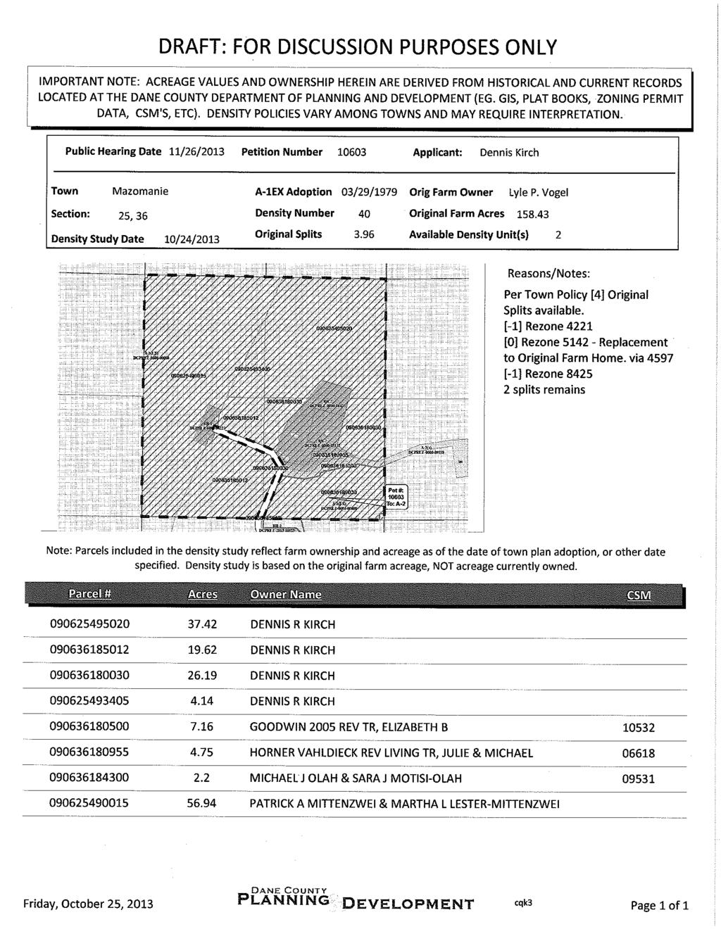
96

97
98
99
100 Town of Mazomanie Town of Roxbury Legend Significant Soils Class Class 1 Class 2 Steep Slopes <VALUE> Slopes < 12% Slopes < 20% Feet Petition Kirch

101 Staff Report Public Hearing: November 26, 2013 Petition: CUP 2253 Zoning Amendment: Town/sect: A-2 Agriculture District to A-2 Oregon Agriculture District Section 24 Zoning and Land Regulation Committee Acres:0.05 Survey Req. No Reason: Communication tower Applicant Reindahl Stone Inc Location: 783 County Highway MM Description: AT&T is proposing to construct a new 150 monopole cell tower on the 2,500 sqft lease / CUP area. AT&T indicates that the site is required to fill in coverage gaps in its network. Observations: The property is an existing non-conforming quarry site zoned A-2. The Jefferson Village residential subdivision is located on the adjoining property to the south, and a vacant, wooded town-owned property adjoins the property to the north. Town Plan: The property is located in the town s Rural Preservation II planning area. The town plan policy on communication towers requires that the owner/operator of the tower enter into an agreement with the town that addresses the tower s, use, design, site location, overall safety and potential impacts to the Town and neighboring Jurisdictions. Based on recently adopted state legislation on cell tower siting, it is unclear if such an agreement can be required as a condition of approval of a conditional use permit (see attached staff report for additional information). Resource Protection Area: No resource protection areas are located on the property. Staff Comments (12/11/13 Update): Staff recommends approval, with conditions. Please see attached staff report, preliminary CUP and final radio frequency (RF) engineering report. Town Action: Approved. 11/26 ZLR Action: Motion by Bollig / Matano to postpone until town action is received; motion carried, 5-0. YGP: 1-0.
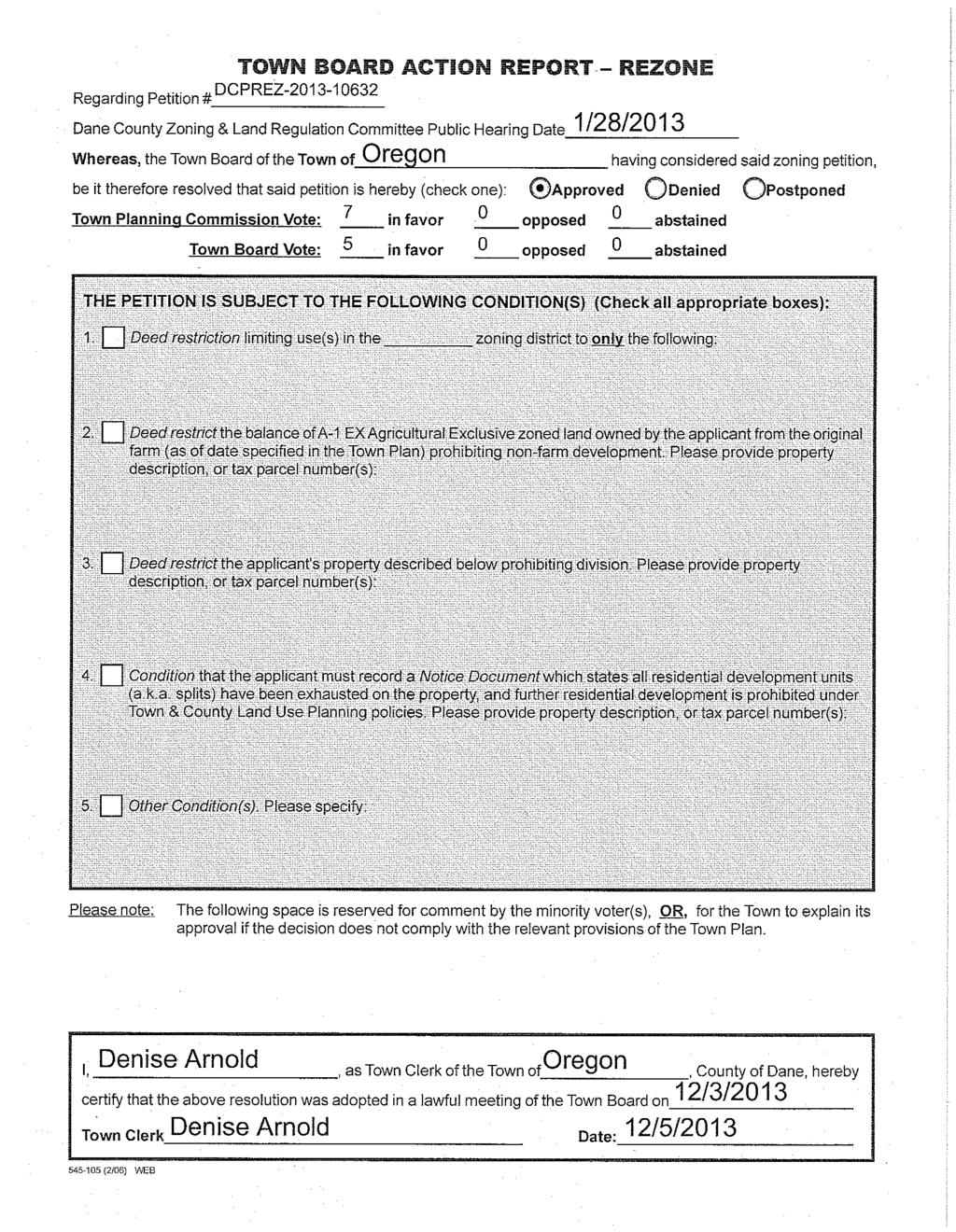
102
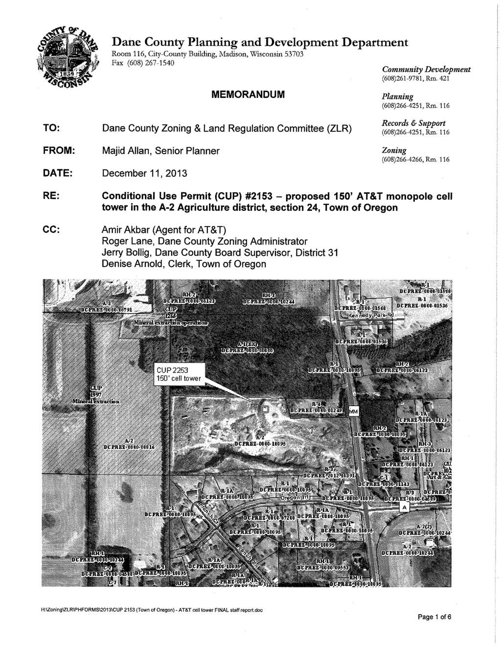
103
104
105
106
107
108
109
110
111
112
113
114
115
116
117
118
119
120 Kennedy Park Rd MM French Ct Oregon Trl A French Gln Legend Feet Significant Soils Steep Slopes Wetland polygons Class Class 1 Class 2 <VALUE> Slopes < 12% Slopes < 20% 100-year Floodplain Hydric Hydric Inclusions CUP 2253 Reindahl Stone
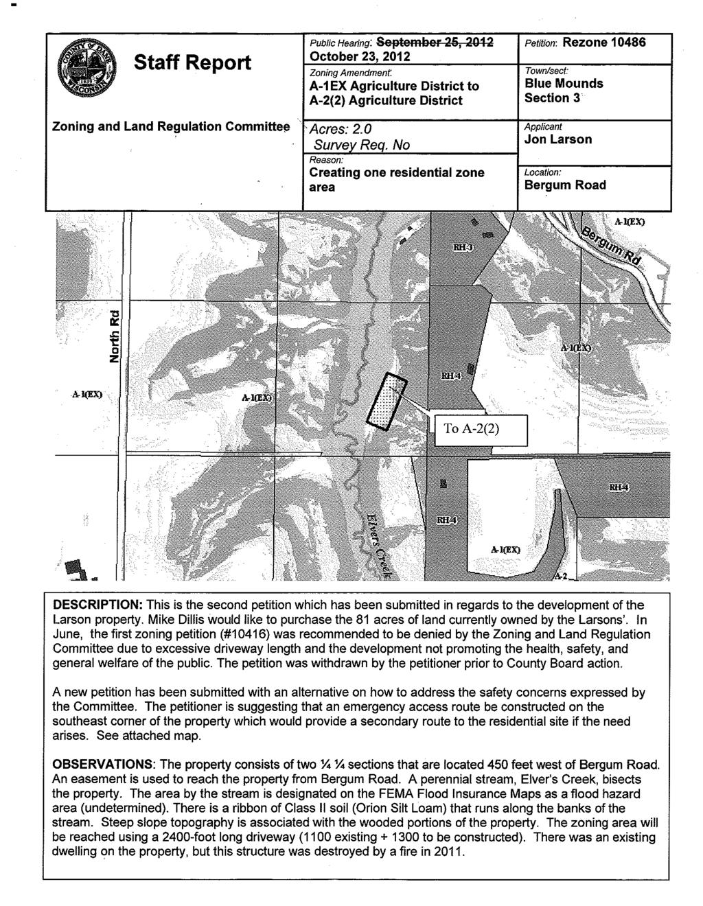
121
122
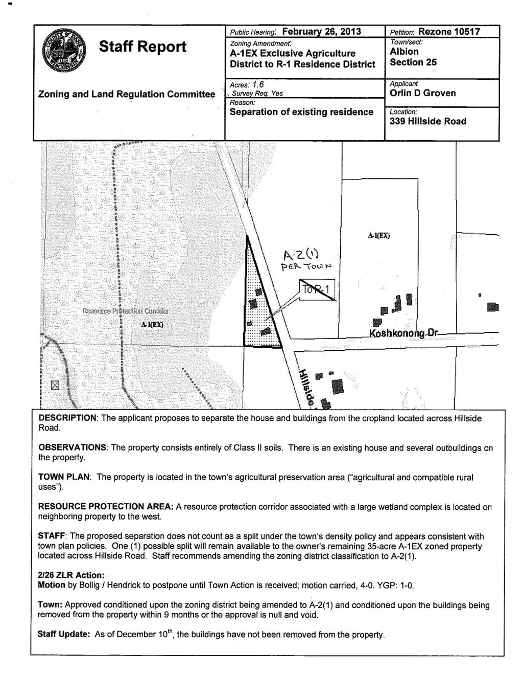
123
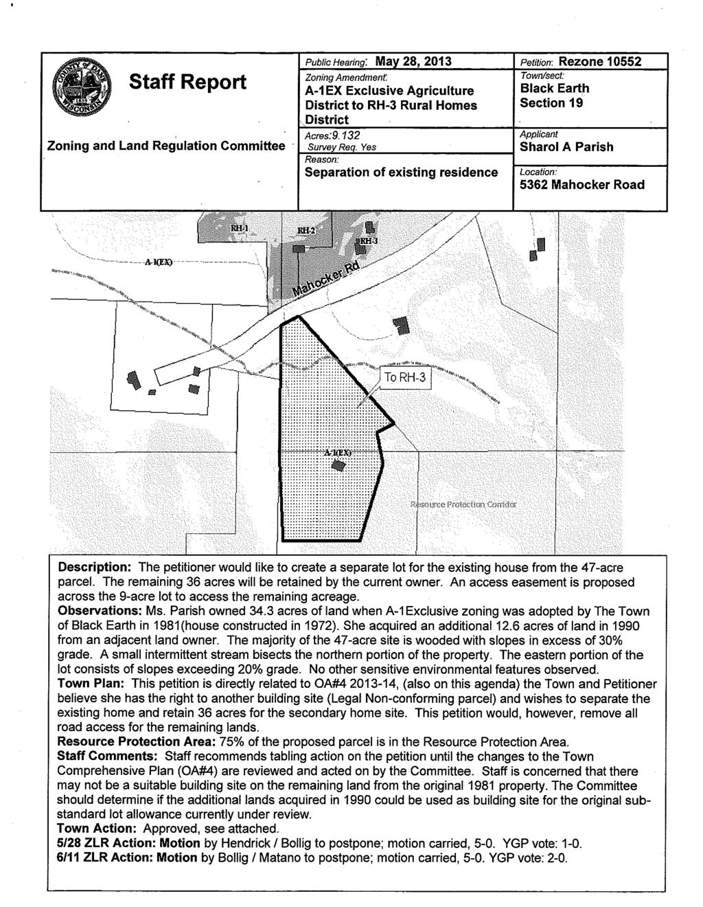
124
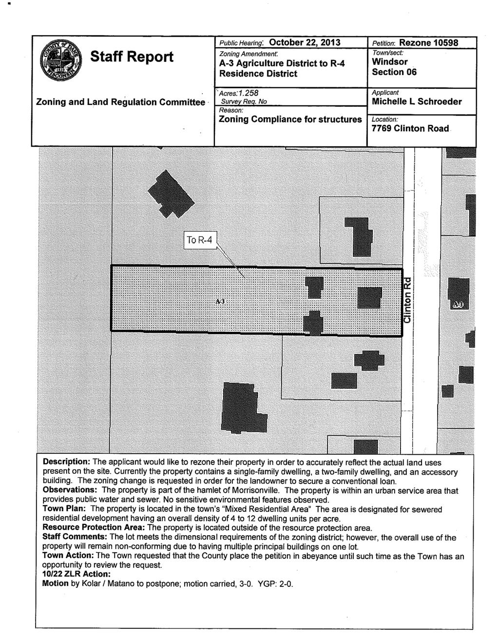
125
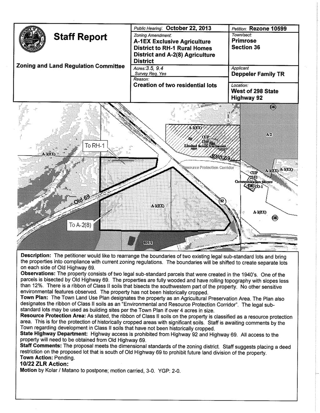
126

127
128
129
DANE COUNTY BOARD OF SUPERVISORS
 ZLR Committee Public Hearing Agenda Page 1 of 3 October 25, 2011 DANE COUNTY BOARD OF SUPERVISORS ZONING & LAND REGULATION COMMITTEE PUBLIC HEARING AGENDA Date: Tuesday, October 25, 2011 Time: 7:30 P.M.
DANE COUNTY BOARD OF SUPERVISORS
 ZLR Committee Work Meeting Agenda Page 1 of 2 December 13, 2011 DANE COUNTY BOARD OF SUPERVISORS ZONING & LAND REGULATION COMMITTEE WORK MEETING AGENDA Date: Tuesday, December 13, 2011 Time: 7:30 P.M.
DANE COUNTY BOARD OF SUPERVISORS
 ZLR Committee Work Meeting Agenda Page 1 of 3 April 12, 2011 DANE COUNTY BOARD OF SUPERVISORS ZONING & LAND REGULATION COMMITTEE WORK MEETING AGENDA Date: Tuesday, April 12, 2011 Time: 7:30 P.M. Location:
ZONING & LAND REGULATION COMMITTEE Dane County Board of Supervisors MINUTES OF THE JANUARY 27, 2009 PUBLIC HEARING
 ZLR Committee Public Hearing Agenda Page 1 of 7 ZONING & LAND REGULATION COMMITTEE Dane County Board of Supervisors MINUTES OF THE JANUARY 27, 2009 PUBLIC HEARING MEMBERS PRESENT: Hendrick, Jensen, Miles,
Dane County Planning & Development Land Division Review
 Dane County Planning & Development Land Division Review Date: June 26, 2012 To: Zoning & Land Regulation Committee From: Daniel Everson, Land Division Review Re: Revere Trails (preliminary plat) Town of
ZONING & LAND REGULATION COMMITTEE WORK MEETING AGENDA
 ZLR Committee Work Meeting Agenda Page 1 of 3 August 14, 2012 DANE COUNTY BOARD OF SUPERVISORS ZONING & LAND REGULATION COMMITTEE WORK MEETING AGENDA Date: Tuesday, August 14, 2012 Time: 7:30 P.M. Location:
DANE COUNTY BOARD OF SUPERVISORS
 ZLR Committee Work Meeting Agenda Page 1 of 2 August 9, 2011 DANE COUNTY BOARD OF SUPERVISORS ZONING & LAND REGULATION COMMITTEE WORK MEETING AGENDA Date: Tuesday, August 9, 2011 Time: 7:30 P.M. Location:
LAND DIVISION AND SUBDIVISION CODE. Town of Springdale Dane County, Wisconsin
 1 2 3 4 5 6 7 8 9 10 11 12 13 14 15 16 17 18 19 20 21 22 23 24 25 26 27 28 29 30 31 32 33 34 35 36 37 38 39 40 41 42 43 44 45 46 Town of Springdale Dane County, Wisconsin Chapter 3. SUBCHAPTER 1 INTRODUCTION
4. If any perennial surface water passes through or along the property lines of the acreage, a minimum of 200 feet or frontage should be required.
 b. Provide adequate acreage for appropriate productive use of rural residential land, such as small numbers of livestock, large gardens, etc. 3. Minimum of 200 feet of frontage on an improved county or
Public Hearing: November 26, 2013 Petition: CUP 2250 Zoning Amendment: Acres:3.78 Survey Req. No Reason: Agriculture Entertainment Wedding barn
 Staff Report Zoning and Land Regulation Committee Public Hearing: November 26, 2013 Petition: CUP 2250 Zoning Amendment: Town/sect: A-1EX Exclusive Agriculture Blue Mounds District to A-1EX Exclusive Section
ZONING & LAND REGULATION COMMITTEE Dane County Board Of Supervisors MINUTES OF THE MAY 22, 2007 PUBLIC HEARING
 ZLR Committee Public Hearing Minutes Page 1 of 5 NOTE: These minutes reflect the notes of the recorder and are subject to correction and approval at a subsequent meeting of the Committee. ZONING & LAND
SUBURBAN AND URBAN RESIDENTIAL LAND USE
 SUBURBAN AND URBAN RESIDENTIAL LAND USE GOAL 1 DISCOURAGE URBAN AND SUBURBAN DEVELOPMENT OUTSIDE INCORPORATED AREAS IN WHITMAN COUNTY, EXCEPT WITHIN DESIGNATED UNINCORPORATED COMMUNITIES, AND THOSE AREAS
CCC XXX Rural Neighborhood Conservation (NC)
") CCC 33.10.XXX Rural Neighborhood Conservation (NC) Purpose: Maintain low density rural residential areas and associated uses commonly found in rural areas consistent with the local character of the distinctive
CCC 33.10.XXX Rural Neighborhood Conservation (NC) Purpose: Maintain low density rural residential areas and associated uses commonly found in rural areas consistent with the local character of the distinctive
Rezoning Staff Report St. Croix County Community Development Committee Gerald & Joan Mellgren Hearing Date: July 16, 2015
 Rezoning Staff Report St. Croix County Community Development Committee Gerald & Joan Mellgren Hearing Date: Property Owners: Gerald & Joan Mellgren Agent: William Mellgren Site Address: 97 230 th Street
TDR RULES AND PROCEDURES TRANSFER OF DEVELOPMENT RIGHTS (TDR) PROGRAM
 PROGRAM") TDR RULES AND PROCEDURES TRANSFER OF DEVELOPMENT RIGHTS (TDR) PROGRAM TOWN OF SPRINGFIELD, DANE COUNTY, WISCONSIN RECOMMENDED BY TOWN PLAN COMMISSION: 7/12/10 TDR RULES AND PROCEDURES, PLAN COMM. RECOMMENDED
TDR RULES AND PROCEDURES TRANSFER OF DEVELOPMENT RIGHTS (TDR) PROGRAM TOWN OF SPRINGFIELD, DANE COUNTY, WISCONSIN RECOMMENDED BY TOWN PLAN COMMISSION: 7/12/10 TDR RULES AND PROCEDURES, PLAN COMM. RECOMMENDED
Land Use. Existing Land Use
 8 Land Use 8.1 Land Use Chapter Purpose and Contents This element includes a brief summary of existing land use conditions and trends followed by a series of goals, objectives, and recommendations to guide
Chapter 100 Planned Unit Development in Corvallis Urban Fringe
 100.100 Scope and Purpose. Chapter 100 Planned Unit Development in Corvallis Urban Fringe (1) All applications for land divisions in the Urban Residential (UR) and Flood Plain Agriculture (FPA) zones within
APPLICATION FOR SUBDIVISION APPROVAL OF A SKETCH PLAN with checklist
 Prior to filing any application for SUBDIVISION approval, the applicant shall request in writing that the zoning administrator schedule a pre-submission conference. APPLICATION TO THE PLANNING BOARD TOWN
DANE COUNTY BOARD OF SUPERVISORS
 ZLR Committee Work Meeting Agenda Page 1 of 3 November 13, 2012 DANE COUNTY BOARD OF SUPERVISORS ZONING & LAND REGULATION COMMITTEE WORK MEETING AGENDA Date: Tuesday, November 13, 2012 Time: 7:00 P.M.
Article XII. R-1 Agricultural-Low Density Residential District
 Article XII R-1 Agricultural-Low Density Residential District Section 1200. Declaration of Legislative Intent In expansion of the Declaration of Legislative Intent and Statement of Community Development
DANE COUNTY BOARD OF SUPERVISORS
 ZLR Committee Public Hearing Agenda Page 1 of 4 September 25, 2012 DANE COUNTY BOARD OF SUPERVISORS ZONING & LAND REGULATION COMMITTEE PUBLIC HEARING AGENDA Date: Tuesday, September 25, 2012 Time: 7:00
DRAFT MINUTES OF THE MEETING OF THE DANE COUNTY ZONING AND LAND REGULATION COMMITTEE HELD ON MAY 25,2004
 ZLR Committee Public Hearing Minutes May 25,2004 Page 1 of6 NOTE:These minutes reflect the notes ofthe recorder and are subject to correction and approval at a subsequent meeting ofthe Committee. DRAFT
Tuesday, February 5, :30 4:00 PM Stoughton Area School District Administration Building, 320 North Street, Staff Development Center
 Stoughton Area Future Urban Development Area (FUDA) Planning Study Steering Committee Meeting #2 City of Stoughton, Towns of Dunn, Dunkirk, Pleasant Springs and Rutland Steering Committee Co Chairs: Donna
Understanding the Conditional Use Process
 Understanding the Conditional Use Process The purpose of this document is to explain the process of applying for and obtaining a conditional use permit in the rural unincorporated towns of Dane County.
Town of Prairie du Sac Sauk County, WI. Land Division Ordinance 07-3
 Town of Prairie du Sac Sauk County, WI Land Division Ordinance 07-3 1.01 DISCLAIMER (1) Multiple Jurisdictions. All persons reviewing the provisions of this Ordinance should be aware that the Town of Prairie
Town of Falmouth s Four Step Design Process for Subdivisions in the Resource Conservation Zoning Overlay District
 Town of Falmouth s Four Step Design Process for Subdivisions in the Resource Conservation Zoning Overlay District All subdivisions shall be designed in accordance with the following four-step process.
8Land Use. The Land Use Plan consists of the following elements:
 8Land Use 1. Introduction The Land Use Plan consists of the following elements: 1. Introduction 2. Existing Conditions 3. Opportunities for Redevelopment 4. Land Use Projections 5. Future Land Use Policies
Group Sewer Only** 80 Ft Frontage* 20,000 Sq. Ft. (.46 acre) Minimum** 120 Ft Frontage* 20,000 Sq. Ft. (.46acre) Minimum** 150 Ft Frontage*
 Minimum** 120 Ft Frontage* 20,000 Sq. Ft. (.46acre) Minimum** 150 Ft Frontage*") Residential Lots Minimum Chart The minimum lot size of any minor subdivision where there is no public sewers shall be as shown below or as required by township zoning and/or the Tuscarawas General Health
Residential Lots Minimum Chart The minimum lot size of any minor subdivision where there is no public sewers shall be as shown below or as required by township zoning and/or the Tuscarawas General Health
Walworth County Farmland Preservation Plan Update, Chapter 1 Plan Summary (Cover Document)
") Background Walworth County Farmland Preservation Plan Update, 2012 Chapter 1 Plan Summary (Cover Document) For over 30-years, the Wisconsin Farmland Preservation Program has served to preserve Walworth
Background Walworth County Farmland Preservation Plan Update, 2012 Chapter 1 Plan Summary (Cover Document) For over 30-years, the Wisconsin Farmland Preservation Program has served to preserve Walworth
FINAL DRAFT 12/1/16, Rev. to 7/18/17
 FINAL DRAFT 12/1/16, Rev. to 7/18/17 (As Adopted 8/8/17 Effective 9/1/17) SHELTON PLANNING AND ZONING COMMISSION Proposed Amendments to Zoning Regulations I. Amend Section 23 PERMITTED USES by inserting
March 26, Sutter County Planning Commission
 March 26, 2003 To: Re: Sutter County Planning Commission Agenda Item #12: Public hearing on Rezoning #03-04 to change the zoning classification of two parcels totaling 324+ acres from the AG (General Agricultural)
Planned Unit Development (PUD). Sections:
. Sections:") Chapter 19.07. Planned Unit Development (PUD). Sections: 19.07.01. Purpose. 19.07.02. PUD Definition and Design Compatibility. 19.07.03. General PUD Standards. 19.07.04. Underlying Zones. 19.07.05. Permitted
Chapter 19.07. Planned Unit Development (PUD). Sections: 19.07.01. Purpose. 19.07.02. PUD Definition and Design Compatibility. 19.07.03. General PUD Standards. 19.07.04. Underlying Zones. 19.07.05. Permitted
STAFF REPORT. Permit History:
 STAFF REPORT Application: Request to rezone property from General Agriculture (AG) to Suburban Residential (a) (R-2a) Applicant: Perry Puncochar Agenda Item: 4(g) Background Information: Proposal: The
PLANNING COMMISSION REPORT Regular Agenda Public Hearing Item
 PC Staff Report 11/12/12 Item No. 2B- 1 PLANNING COMMISSION REPORT Regular Agenda Public Hearing Item ITEM NO. 2B: A TO GPI; 110 ACRES; E OF K-10 & N OF W 6 TH ST (MKM) : Consider a request to rezone approximately
** If your lot does not meet the requirements above, please read Sec below
 Sec. 13-1-60 Zoning District Dimensional Requirements. For the Zoning Dept To Issue a Land Use Permit The Following Dimensions are Required. Minimum Side and Rear Yards s Lakes Classification Minimum Class
MIDWAY CITY Municipal Code
 MIDWAY CITY Municipal Code TITLE 9 ANNEXATION CHAPTER 9.01 PURPOSE CHAPTER 9.02 GENERAL REQUIREMENTS CHAPTER 9.03 PROPERTY OWNER INITIATION OF ANNEXATION CHAPTER 9.04 PROCEDURES FOR CONSIDERATION OF PETITION
Conservation Design Subdivisions
 Conservation Design Subdivisions An excerpt from the Rules and Regulations Governing Division of Land in Sheridan County, Wyoming, November 5, 2010 Sheridan County Public Works Department 224 S. Main Street
GWINNETT COUNTY CSO CONSERVATION SUBDIVISION OVERLAY DISTRICT REQUIREMENTS
 GWINNETT COUNTY CSO CONSERVATION SUBDIVISION OVERLAY DISTRICT REQUIREMENTS Section 1316. CSO Conservation Subdivision Overlay District. 1. Purposes. The purposes of this overlay district are as follows:
ARTICLE V AGRICULTURAL PRESERVATION AND RURAL RESIDENTIAL DISTRICT
 ARTICLE V AP AGRICULTURAL PRESERVATION AND RURAL RESIDENTIAL DISTRICT Section 500. PURPOSE It is the purpose of the AP, Agricultural Preservation and Rural Residential District, to foster the preservation
DANE COUNTY BOARD OF SUPERVISORS
 ZLR Committee Public Hearing Agenda Page 1 of 4 October 23, 2012 DANE COUNTY BOARD OF SUPERVISORS ZONING & LAND REGULATION COMMITTEE PUBLIC HEARING AGENDA Date: Tuesday, October 23, 2012 Time: 7:00 P.M.
Guide to Combined Preliminary and Final Plats
 Guide to Combined Preliminary and Final Plats Introduction The Douglas County is committed to providing open, transparent application processes to the public. This Guide is provided to assist anyone interested
Guide to Preliminary Plans
 Guide to Preliminary Plans Introduction The Douglas County is committed to providing open, transparent application processes to the public. This Guide is provided to assist anyone interested in the procedures
Town of Cary, North Carolina Rezoning Staff Report 14-REZ-24 Indian Wells Road Properties Town Council Meeting November 20, 2014
 Town of Cary, North Carolina Rezoning Staff Report 14-REZ-24 Indian Wells Road Properties Town Council Meeting November 20, 2014 REQUEST To amend the Town of Cary Official Zoning Map by revising a condition
LAND USE APPLICATION
 Lincoln County Department of Planning & Development 210 SW 2nd Street, Newport, OR 97365 Phone (541) 265-4192 Fax (541) 265-6945 LAND USE APPLICATION TO BE COMPLETED BY STAFF Conditional Use Non-Conforming
1. an RSF-R, RSF-1, RSF-2, RSF-4, RMF-5, or RMF-8 zoning district; or
 Chapter 9 INCENTIVES 9.1 General 9.1.1 Review and Approval Procedure Projects requesting bonuses under this chapter for land that has not been platted, or for land that is being voluntarily replatted,
Town of Norwich, Vermont SUBDIVISION REGULATIONS
 Town of Norwich, Vermont SUBDIVISION REGULATIONS Adopted: August 6, 2002 Amended: February 8, 2006 Prepared by Norwich Planning Commission with the assistance of: Burnt Rock Inc. A ssociates in Community
OPEN SPACE RESIDENTIAL DEVELOPMENT (OSRD) MODEL SITE PLAN BYLAW
 MODEL SITE PLAN BYLAW") OPEN SPACE RESIDENTIAL DEVELOPMENT (OSRD) MODEL SITE PLAN BYLAW 1) PURPOSE AND INTENT a) The Primary Purposes for OSRD are the following: i) To allow for greater flexibility and creativity in the design
OPEN SPACE RESIDENTIAL DEVELOPMENT (OSRD) MODEL SITE PLAN BYLAW 1) PURPOSE AND INTENT a) The Primary Purposes for OSRD are the following: i) To allow for greater flexibility and creativity in the design
Town of Cary, North Carolina Rezoning Staff Report 14-REZ-20 Habitat for Humanity Evans Road Town Council Meeting October 16, 2014
 Town of Cary, North Carolina Rezoning Staff Report 14-REZ-20 Habitat for Humanity Evans Road Town Council Meeting October 16, 2014 REQUEST To amend the Town of Cary Official Zoning Map by rezoning 0.53
Guide to Minor Developments
 Guide to Minor Developments Introduction The Douglas County (DCD) is committed to providing open, transparent application processes to the public. This Guide is provided to assist anyone interested in
DRAFT FOR PUBLIC HEARING (rev. March, 2016)
") Chapter 200. ZONING Article VI. Conservation/Cluster Subdivisions 200-45. Intent and Purpose These provisions are intended to: A. Guide the future growth and development of the community consistent with
Chapter 200. ZONING Article VI. Conservation/Cluster Subdivisions 200-45. Intent and Purpose These provisions are intended to: A. Guide the future growth and development of the community consistent with
TOWN OF PLEASANT SPRINGS DANE COUNTY, WISCONSIN RECORD OF THE JOINT PLAN COMMISSION & TOWN BOARD MEETING OF SEPTEMBER 5, 2018
 TOWN OF PLEASANT SPRINGS DANE COUNTY, WISCONSIN RECORD OF THE JOINT PLAN COMMISSION & TOWN BOARD MEETING OF SEPTEMBER 5, 2018 MEETING LOCATION: Town Hall, 2354 County Road N, Stoughton WI 53589 PLAN COMMISSION
Certified Survey Map (CSM) Submittal Updated: 6/29/18
 Submittal Updated: 6/29/18") Certified Survey Map (CSM) Submittal Updated: 6/29/18 Town of Middleton 7555 W. Old Sauk Road Verona, WI 53593-9700 Phone: 608-833-5887 Fax: 608-833-8996 info@town.middleton.wi.us The Town of Middleton
Certified Survey Map (CSM) Submittal Updated: 6/29/18 Town of Middleton 7555 W. Old Sauk Road Verona, WI 53593-9700 Phone: 608-833-5887 Fax: 608-833-8996 info@town.middleton.wi.us The Town of Middleton
Agenda ZNR Committee Page 1 DANE COUNTY BOARD OF SUPERVISORS
 Agenda ZNR Committee Page 1 DANE COUNTY BOARD OF SUPERVISORS ZONING & NATURAL RESOURCES Agenda Committee Date: APRIL 17 2001 Time: 7:30 P.M. Location: ROOM 2D CCB PLEASE NOTE: Persons requiring an interpreter,
ATTENDING THE MEETING Robert Balogh, Vice-Chairman Sonia Stopperich, Supervisor Marcus Staley, Supervisor Bob Ross, Supervisor
 SPECIAL HEARING - TUESDAY, APRIL 12, 2016 PAGE 1 The North Strabane Township Board of Supervisors held a Special Meeting- Conditional Use Hearing, Tuesday, April 12, 2016, at approximately 6:30 P.M., at
Town of Cary, North Carolina Rezoning Staff Report 14-REZ-31 Cary Park PDD Amendment (Waterford II) Town Council Meeting January 15, 2015
 Town Council Meeting January 15, 2015") Town of Cary, North Carolina Rezoning Staff Report 14-REZ-31 Cary Park PDD Amendment (Waterford II) Town Council Meeting January 15, 2015 REQUEST To amend the Town of Cary Official Zoning Map by amending
Town of Cary, North Carolina Rezoning Staff Report 14-REZ-31 Cary Park PDD Amendment (Waterford II) Town Council Meeting January 15, 2015 REQUEST To amend the Town of Cary Official Zoning Map by amending
ARTICLE III GENERAL PROCEDURES, MINOR PLANS AND FEE SCHEDULES
 ARTICLE III GENERAL PROCEDURES, MINOR PLANS AND FEE SCHEDULES 301. Prior to Submission a. Copies of this Ordinance shall be available on request, at cost, for the use of any person who desires information
Umatilla County Department of Land Use Planning
 Umatilla County Department of Land Use Planning 216 SE 4 th ST, Pendleton, OR 97801, (541) 278-6252 PROCESSING TYPE I & III APPLICATIONS Land Division, Type I - IV Supplemental Application & Information
ARTICLE XI - CONSERVATION SUBDIVISIONS
 ARTICLE XI - CONSERVATION SUBDIVISIONS Section 1101: Purpose and Intent. This Article is intended to provide for residential subdivisions that are designed based first and foremost on the preservation
4. facilitate the construction of streets, utilities and public services in a more economical and efficient manner;
 PVPC MODEL BYLAW BY-RIGHT CLUSTER ZONING BYLAW Prepared by Pioneer Valley Planning Commission Revised: October 2001 1.00 Development 1.01 Development Allowed By Right Development in accordance with this
TOWN OF ORO VALLEY PLANNING & ZONING COMMISSION MEETING DATE: December 6, 2011
 PLANNING & ZONING COMMISSION MEETING DATE: December 6, 2011 TO: FROM: SUBJECT: PLANNING & ZONING COMMISSION Matt Michels, Senior Planner mmichels@orovalleyaz.gov; tel. 229-4822 Public Hearing: Rancho de
Guide to Replats. Step 1. Step 2. Step 3. Step 4. Step 5. Step 6. Step 7. Step 8. Step 9. Step 10
 Guide to Replats Introduction Douglas County is committed to providing open, transparent application processes to the public. This Guide is provided to assist anyone interested in the procedures and expectations
CHAPTER 3 PRELIMINARY PLAT
 10-3-1 10-3-3 SECTION: CHAPTER 3 PRELIMINARY PLAT 10-3-1: Consultation 10-3-2: Filing 10-3-3: Requirements 10-3-4: Approval 10-3-5: Time Limitation 10-3-6: Grading Limitation 10-3-1: CONSULTATION: Each
CHAPTER 5A A-1 AGRICULTURAL CONSERVATION DISTRICT
 CHAPTER 5A A-1 AGRICULTURAL CONSERVATION DISTRICT SECTION 5A.01 DESCRIPTION AND PURPOSE. It is recognized that the public health and welfare of the citizens of Salem Township, Allegan County, the state
CONDITIONAL USE PERMIT (CUP)
") CONDITIONAL USE PERMIT (CUP) LAND DEVELOPMENT APPLICATION FORM DEPARTMENT OF PLANNING 300 East Main Street, Sun Prairie, WI 53590-2227 (608)825-1107 FAX (608)825-1194 Applications will not be processed
CONDITIONAL USE PERMIT (CUP) LAND DEVELOPMENT APPLICATION FORM DEPARTMENT OF PLANNING 300 East Main Street, Sun Prairie, WI 53590-2227 (608)825-1107 FAX (608)825-1194 Applications will not be processed
Comprehensive Plan 2030
 Introduction The purpose of this chapter of the Comprehensive Plan is to accurately describe, in words and images, the goals and visions for the future of Clearfield, as determined by the people who live
Town zoning: A good option for your town?
 Photo credit: Landslides Aerial Photography Town zoning: A good option for your town? Lynn Markham Town of Auburn May 27, 2015 Main points 1. Zoning is one tool to implement community plans 2. What does
MINNETONKA PLANNING COMMISSION June 2, A conditional use permit for 2,328 square feet of accessory structures at 4915 Highland Road
 MINNETONKA PLANNING COMMISSION June 2, 2016 Brief Description A conditional use permit for 2,328 square feet of accessory structures at Recommendation Recommend the city council adopt the resolution approving
Amendment to the Zoning and Subdivision Ordinances; Consider Repeal Cluster Development Standards
 2 Board of Supervisors Meg Bohmke, Chairman Gary F. Snellings, Vice Chairman Jack R. Cavalier Thomas C. Coen L. Mark Dudenhefer Wendy E. Maurer Cindy C. Shelton February 28, 2018 Thomas C. Foley County
LETTER OF APPLICATION
 Description of Proposed Land Division: LETTER OF APPLICATION The proposed land division would split a 1.94 acres rectangular lot into two lots. The general configuration would have one lot in front of
PLANNING & DEVELOPMENT COMMITTEE MINUTES
 Eau Claire County PLANNING & DEVELOPMENT COMMITTEE MINUTES Tuesday, 6:00 PM *Please note earlier start time* Eau Claire County Courthouse 721 Oxford Avenue Room 1277 Eau Claire, Wisconsin Members Present:
ARTICLE I ZONE BASED REGULATIONS
 ARTICLE I ZONE BASED REGULATIONS RZC 21.08 RESIDENTIAL REGULATIONS 21.08.290 Cottage Housing Developments A. Purpose. The purpose of the cottage housing requirements is to: 1. Provide a housing type that
CONDITIONAL USE PERMIT Application Packet
 CONDITIONAL USE PERMIT Application Packet Community Development Department 1020 East Pioneer Road, Draper, UT 84020 (801) 576-6539 Fax (801) 576-6526 Dear Applicant, This application packet has been developed
Dane County Land Use Handbook
 Dane County Land Use Handbook Dane County Board of Supervisors Prepared by The Office of the County Board Last revision 4/6/98 Summary September 15, 1997 Dane County has land area of 1,202 square miles,
STAFF REPORT. Applicable Statutes/Ordinances: Corinna Township Subdivision Ordinance
 STAFF REPORT Application: Preliminary plat application to subdivide an approximate 6.47 acre parcel into two lots (2.81 and 3.42 acres) with a 0.24 acre remainder to be attached to an existing nonconforming
Section Intent
 Section 246. 1. Intent 2. Authority a. It is the intent of these Transfer of Development Rights (TDR s) regulations to encourage the preservation of natural resources and facilitate orderly growth in the
STATE OF MICHIGAN COUNTY OF MARQUETTE, TOWNSHIP OF NEGAUNEE LAND DIVISION, SUBDIVISION AND CONDOMINIUM ORDINANCE
 STATE OF MICHIGAN COUNTY OF MARQUETTE, TOWNSHIP OF NEGAUNEE LAND DIVISION, SUBDIVISION AND CONDOMINIUM ORDINANCE Adopted: August 8 th, 2008 Effective: August 28 th, 2008 Sec.100. Title ARTICLE I GENERAL
2030 General Plan. December 6, 7 pm
 2030 General Plan GPAC Meeting #9 GPAC Meeting #9 December 6, 7 pm City Council Input on Working Draft Land Use Map Council discussed GPAC & PC versions of the working draft land use map 11/28 Council
Plat Alteration request of Barkley North LLC re 3400 Sussex Drive (aka Village on the Green Division #5 Tract B) 08/26/2015
 08/26/2015") Hearing Examiner Summary and Decision Hearing Examiner No. Planning No. Incident No. Filing Date City Contact Hearing Date Description Decision Date Decision Summary HE-15-PL-022 SUB2015-00019 06/22/2015
Hearing Examiner Summary and Decision Hearing Examiner No. Planning No. Incident No. Filing Date City Contact Hearing Date Description Decision Date Decision Summary HE-15-PL-022 SUB2015-00019 06/22/2015
MAJOR RESIDENTIAL AND NONRESIDENTIAL SUBDIVISIONS
 Lawrence-Douglas County MAJOR RESIDENTIAL AND NONRESIDENTIAL SUBDIVISIONS Preliminary Plats The applicant shall schedule a Pre-Application meeting with Planning Staff at least seven (7) working days prior
Cover Letter with Narrative Statement
 Cover Letter with Narrative Statement March 31, 2017 rev July 27, 2017 RE: Rushton Pointe Residential Planned Unit Development Application for Public Hearing for RPUD Rezone PL2015 000 0306 Mr. Eric Johnson,
CITY OF ELK GROVE CITY COUNCIL STAFF REPORT
 AGENDA ITEM NO. 9.2 CITY OF ELK GROVE CITY COUNCIL STAFF REPORT AGENDA TITLE: A public hearing to consider a Specific Plan Amendment to the Laguna Ridge Specific Plan and a Rezone of approximately 4.14
DOUGLAS COUNTY ZONING RESOLUTION Section 4 LRR - Large Rural Residential District 3/10/99. -Section Contents-
 SECTION 4 LRR LARGE RURAL RESIDENTIAL DISTRICT -Section Contents- 401 Intent... 4-2 402 Principal Uses... 4-2 403 Accessory Uses... 4-3 404 Uses Permitted by Special Review... 4-4 405 Land Dedication...
Planner Ken Jaworski. Approval of Minutes: A. Approval of the minutes of the Wednesday, July 8 th, 2015 Regular Plan Commission Meeting.
 Approved 09/09/2015 TOWN OF CLAYTON Town Plan Commission Meeting Minutes 7:00 P.M. on Wednesday, August 12 th, 2015 Town Office Meeting Room, 8348 County Road T, Larsen, WI 54947 I. Call to Order: A. Notice
a. It is the intent of these regulations to encourage the preservation of natural resources and facilitate orderly growth in the County.
 Part V Transfer of Development Rights Section 246. 1. Intent a. It is the intent of these regulations to encourage the preservation of natural resources and facilitate orderly growth in the County. b.
PLANNING & DEVELOPMENT
 PLANNING & DEVELOPMENT STAFF REPORT Rezoning PETITION: APPLICANT: PROPERTY OWNER: TYPE OF REQUEST: SIZE OF TRACT: LOCATION: (#17-22) Rezone from A-PUD (Agri-Business Planned Unit Development) to A-PUD
19.12 CLUSTER RESIDENTIAL DISTRICT
 Chapter 19.12 CLUSTER RESIDENTIAL DISTRICT (Adopted 12/22/2003; Ordinance #0061970). Amended 7/3/17, Ordinance #079100. Section 19.12.010 - Declaration of Intent. The Cluster Residential District provides
Napa County Planning Commission Board Agenda Letter
 Agenda Date: 9/20/2017 Agenda Placement: 8C Napa County Planning Commission Board Agenda Letter TO: FROM: Napa County Planning Commission Charlene Gallina for David Morrison - Director Planning, Building
O-I (Office-Institutional) and AG-1(Agricultural)
 and AG-1(Agricultural)") PROPERTY INFORMATION ADDRESS 3503 and 3505 Bethany Bend DISTRICT, LAND LOTS 2/1 973 and 974 OVERLAY DISTRICT State Route 9 PETITION NUMBERS EXISTING ZONING O-I (Office-Institutional) and AG-1(Agricultural)
PROPERTY INFORMATION ADDRESS 3503 and 3505 Bethany Bend DISTRICT, LAND LOTS 2/1 973 and 974 OVERLAY DISTRICT State Route 9 PETITION NUMBERS EXISTING ZONING O-I (Office-Institutional) and AG-1(Agricultural)
Residential Project Convenience Facilities
 Standards for Specific Land Uses 35.42.220 E. Findings. The review authority shall approve a Land Use Permit in compliance with Subsection 35.82.110.E (Findings required for approval) or a Conditional
Article Optional Method Requirements
 Article 59-6. Optional Method Requirements [DIV. 6.1. MPDU DEVELOPMENT IN RURAL RESIDENTIAL AND RESIDENTIAL ZONES Sec. 6.1.1. General Requirements... 6 2 Sec. 6.1.2. General Site and Building Type Mix...
Agenda Information Sheet
 Page 90 Agenda Information Sheet December 13, 2018 Agenda Item Z-18-10 - Conduct a public hearing and consider approval of an ordinance rezoning a 33.4 tract of land out of the H. Teal Survey Abstract
APPLICATION PROCEDURE
 ANTRIM PLANNING BOARD P. O. Box 517 Antrim, New Hampshire 03440 Phone: 603-588-6785 FAX: 603-588-2969 APPLICATION FORM AND CHECKLIST FOR MINOR OR MAJOR SITE PLAN REVIEW File Date Received By APPLICATION
(Draft Glenville ordinance, June 2008) ARTICLE XXII Transfer of Development Rights
 ARTICLE XXII Transfer of Development Rights") (Draft Glenville ordinance, June 2008) ARTICLE XXII Transfer of Development Rights 270-161. Purpose. The primary purpose of establishing a transfer of development rights (TDR) program is to permanently
(Draft Glenville ordinance, June 2008) ARTICLE XXII Transfer of Development Rights 270-161. Purpose. The primary purpose of establishing a transfer of development rights (TDR) program is to permanently
REZONING APPLICATION INSTRUCTIONS
 REZONING APPLICATION INSTRUCTIONS All required information, as stated on the Rezoning Application Checklist, must be included to qualify as a complete application. Upon receipt, staff will review the application
Community Development Department Planning Division 1600 First Street + P.O. Box 660 Napa, CA Napa (707)
") Community Development Department Planning Division 1600 First Street + P.O. Box 660 Napa, CA 94559-0660 Napa (707) 257-9530 PLANNING COMMISSION STAFF REPORT JUNE 16, 2016 AGENDA ITEM # 6.B. 16-0056-EXT;
Community Development Department Planning Division 1600 First Street + P.O. Box 660 Napa, CA 94559-0660 Napa (707) 257-9530 PLANNING COMMISSION STAFF REPORT JUNE 16, 2016 AGENDA ITEM # 6.B. 16-0056-EXT;
UPPER MOUNT BETHEL TOWNSHIP NORTHAMPTON COUNTY, PENNSYLVANIA
 UPPER MOUNT BETHEL TOWNSHIP NORTHAMPTON COUNTY, PENNSYLVANIA JOINDER DEED / LOT CONSOLIDATION TOWNSHIP REVIEW PROCESS When accepting proposed Joinder Deeds / Lot Consolidations, review the Joinder Deed
PLANNED RESIDENTIAL DEVELOPMENT (PRD)
") PLANNED RESIDENTIAL DEVELOPMENT SECTION 10. PLANNED RESIDENTIAL DEVELOPMENT (PRD) 10.1 Purpose Planned Residential Development allows by special permit from the Board an alternative pattern of residential
PLANNED RESIDENTIAL DEVELOPMENT SECTION 10. PLANNED RESIDENTIAL DEVELOPMENT (PRD) 10.1 Purpose Planned Residential Development allows by special permit from the Board an alternative pattern of residential
Business Item Community Development Committee Item:
 Business Item Community Development Committee Item: 2008-124 C Meeting date: July 21, 2008 ADVISORY INFORMATION Date: May 21, 2008 Subject: Flexible Residential Development Ordinance Guidelines District(s),
MINOR SUBDIVISION COMMITTEE COUNTY OF MONTEREY, STATE OF CALIFORNIA
 MINOR SUBDIVISION COMMITTEE COUNTY OF MONTEREY, STATE OF CALIFORNIA RESOLUTION NO. 05010 In the matter the application GIANNINI FAMILY LIMITED PARTNERSHIP (PLN040273) APN# 113-071-006-000 FINDINGS & DECISION
MONTGOMERY COUNTY PLANNING DEPARTMENT THE MARYLAND-NATIONAL CAPITAL PARK AND PLANNING COMMISSION
 MONTGOMERY COUNTY PLANNING DEPARTMENT THE MARYLAND-NATIONAL CAPITAL PARK AND PLANNING COMMISSION MCPB Item No. 8 Date: 03-07-13 Sonoma, Preliminary Plan, 120130040 Melissa Williams, Senior Planner, Melissa.williams@montgomeryplanning.org,