Computer Assisted Mass Appraisal (CAMA) System
|
|
|
- Bryce Neal
- 5 years ago
- Views:
Transcription
1 Computer Assisted Mass Appraisal (CAMA) System September 8, 2009 Bruce Grandjean President, Grandjean & Braverman, Inc. Michael Wolfe Software Engineer, Grandjean & Braverman, Inc. John Nolan Chief Assessor, Wayne County John McCormick Assessor, Wayne County Dennis Ford MIS Director, Wayne County This presentation available for download at:

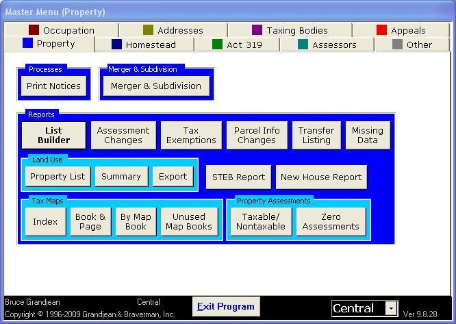
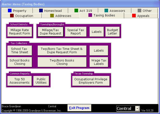
2 Program Highlights In use and continually improved since 1996 o Runs on any of the current versions of Windows including Version 7 when released o Written in Microsoft Access (runs on free runtime) o Data currently stored using Microsoft SQL Server Supports laptop computers for in-field use o Minimal hardware requirements, 1.83 GHz processor, 1 GB RAM, 50GB Hard drive o Automatic nightly synchronization Designed to allow in-house reassessment Tabbed User Interface Easy selection of Central, Local or Archived data Integrates with Tax Collection and Tax Claim programs
 Previous Tax Map Number Previous Owner s Name All columns can be sorted")
3 Universal Search Automatically searches the following: o Clients by: Control number Name Mailing Address o Properties by: Control Number Parent Control Number Tax Map Number Owner s Name Physical Address Deed Book/Page Act 319 Book/Page Easement Book/Page (e.g., Gas Leases) Previous Tax Map Number Previous Owner s Name All columns can be sorted

4 Special Search Options Example Searches: returns properties with tax map beginning and properties with a previous tax map beginning properties with an ownership, easement or Act 319 enrollment recorded in deed book /229- properties with an ownership, easement or Act 319 enrollment recorded in deed book 0785 on page 0229 A: *Miller- returns properties on Miller Rd and clients who get mail at Miller Ave, but not properties owned by John Miller D: Hideout- returns all properties in the Hideout development E: Oil and Gas- returns all properties with an Oil and Gas lease G: Chesapeake- returns all properties where Chesapeake Appalachia, LLC owns an interest in a gas lease L: Cemetery- returns a list of all the cemeteries in the county {Pending}- returns all properties with pending Clean & Green applications, sortable by date the application was returned {bgrandjean}- returns all properties in the bgrandjean list as created in the Property List Builder

5 Parcel Tab Property Form tabbed for different sections of information Standard information above tabs Buttons below access additional reports and functions Parcel tab contains summary information o Acreage o Assessed Values o Notes o School District o Addresses from GIS o Parent Control Number Integrated with ESRI GIS mapping software

6 Land Tab Acreage in segments for different valuations and adjustments including Clean and Green Adjustments for topography and other features Display in either acreage or square feet Utility Values Neighborhood

7 Clean and Green Tab Displays acreage divided up by soil types Information imported from GIS system Calculates rollback amounts for full and partial breaches
8 Start of County, Township or Borough tax year Januar 2009 Property No Owner (s): JOHN MC ANDREW 2008 Control No Breach No /31/09 Act 319 Book 2646 Page MEMORIAL LINKS RD 06/29/09 Acres Removed 2 WAYMART, PA Start of School tax year July 1, Start Date for County, Township or Borough Rollback Mailing Address: Start Date for School Rollback Normal Assessment Clean and Green Assessment Acres Enrolled Difference (Savings) Day (s) subject to Rollback Adjustment for day(s) subject to Rollback Percent of Acres Millage Sub Total Days at Rate 1 Interest Rate 1 Days at Rate 2 Interest Rate 2 Interest Sub Total Plus Interest Tax Budget Year County, Municipality and School District 2009 County of: Wayne $281,100 $116, $165, $165, % $ % $0.00 $ Township or Borough of: MT PLEASANT TOWNSHIP $281,100 $116, $165, $165, % $ % $0.00 $ / 2009 School District: Forest City Regional School District $281,100 $114, $166, $165, % $ % $0.00 $28.46 Total by Year: $36.22 $0.00 $ County of: Wayne $281,100 $114, $166, $166, % $ % % $0.39 $ Township or Borough of: MT PLEASANT TOWNSHIP $281,100 $114, $166, $166, % $ % % $0.08 $ / 2008 School District: Forest City Regional School District $281,100 $113, $167, $167, % $ % % $0.79 $26.83 Total by Year: $33.86 $1.26 $ County of: Wayne $281,100 $113, $167, $167, % $ % % $0.69 $ Township or Borough of: MT PLEASANT TOWNSHIP $281,100 $113, $167, $167, % $ % % $0.16 $ / 2007 School District: Forest City Regional School District $281,100 $115, $165, $165, % $ % % $2.25 $27.21 Total by Year: $32.05 $3.10 $ Wayne 2006 MT PLEASANT TOWNSHIP Forest City Regional School District County of: $281,100 $115, $165, $165, % $ % % $1.03 $6.73 Township or Borough of: $281,100 $115, $165, $165, % $ % % $0.23 $ / 2006 School District: $281,100 $107, $173, $173, % $ % % $3.52 $26.93 Total by Year: $30.41 $4.78 $ Wayne 2005 MT PLEASANT TOWNSHIP Forest City Regional School District County of: $281,100 $107, $173, $173, % $ % % $1.10 $5.67 Township or Borough of: $281,100 $107, $173, $173, % $ % % $0.33 $ / 2005 School District: $0 366 $0 0.00% $ % % $0.00 $0.00 Total by Year: $5.94 $1.43 $ Wayne 2004 MT PLEASANT TOWNSHIP Forest City Regional School District County of: $0 366 $0 0.00% $ % % $0.00 $0.00 Township or Borough of: $0 366 $0 0.00% $ % % $0.00 $ / 2004 School District: $0 365 $0 0.00% $ % % $0.00 $0.00 Total by Year: $0.00 $0.00 $ Wayne County of: $0 365 $0 0.00% $ % % $0.00 $0.00 Township or Borough of: $0 365 $0 0.00% $ % % $0.00 $ MT PLEASANT TOWNSHIP Forest City Regional School District 2002 / 2003 School District: $0 365 $0 0.00% $ % % $0.00 $0.00 Total by Year: $0.00 $0.00 $ Wayne County of: $0 0 $0 0.00% $ % $0.00 $0.00 Township or Borough of: $0 0 $0 0.00% $ % $0.00 $ MT PLEASANT TOWNSHIP Forest City Regional School District 2001 / 2002 School District: $0 1 $0 0.00% $ % $0.00 $0.00 Total by Year: $0.00 $0.00 $0.00 County roll-back payable to Tax Claim Bureau County roll-back interest payable to Tax Claim Bureau County roll-back and interest payable to Tax Claim Bureau $29.01 Township or Borough roll-back payable to Tax Claim Bureau $6.60 $3.21 Township or Borough roll-back interest payable to Tax Claim Bureau $0.80 $32.22 Township or Borough roll-back and interest payable to Tax Claim Bureau $7.40 School roll-back payable to Tax Claim Bureau $ Roll-back payable to Tax Claim Bureau $ School roll-back interest payable to Tax Claim Bureau $6.56 Interest payable to Tax Claim Bureau $10.57 School roll-back and interest payable to Tax Claim Bureau $ Total $ Tax Claim Bureau fee $25.00 Roll-back tax will not be filed until violation/sub-division takes place. Civil Penalties $0.00 TOTAL OWED TO TAX CLAIM BUREAU $ Assessment Office/John F. Nolan, Chief Assessor Date 08/18/09 Tax Claim Bureau Date

9 Dwelling Tab Detailed information about dwelling used to calculate assessment Adjustment factors including quality, cost/design, physical condition, obsolescence, and rehab Square footage imported from Apex drawings Trailer registration information Addition descriptions and sizes Percentages qualifying for Homestead/Farmstead adjustments

10 Auxiliary Tab Information used for valuation including construction, condition and quality Size imported from Apex drawing Percentage qualified for farmstead adjustments

11 Drawings Tab Multiple pages per drawing Multiple drawings per parcel Preview drawing pages without opening sketch program Copy or Transfer sketch to a different parcel

12 Apex Sketch Software Fully integrated

13 Summary Tab Button to recompute cost value Button to reselect comparables for market value Comparables report Selection of six different methods for determining value Entry of reason for change as part of finalization process


14 Subject Comparable #1 Comparable #2 Comparable #3 Comparable #4 Comparable #5 Control# TaxMap Address PINTLER RD BETHEL SCHOOL R PLEASANT VALLEY GRANGE RD ROCKY VIEW DR Neighborhood BERLIN BERLIN DYBERRY DYBERRY CHIMNEY HILL WAYMART Neighborhood Grp MIDDLE TIER 1 MIDDLE TIER 1 MIDDLE TIER 1 MIDDLE TIER 1 MIDDLE TIER 1 MIDDLE TIER 1 Acreage/Value 40 90, , , , , ,900 Occupancy Single Fam Single Fam Single Fam Single Fam Single Fam Single Fam Style Old Style Old Style Colonial Old Style Cape Conventional Story Ht. 1 1/2 Story 1 1/2 Story 2 Story 1 1/2 Story 1 1/2 Story 1 1/2 Story Exterior Walls Wood Siding Alum/Vinyl Alum/Vinyl Wood Siding Shingle Shingle Total Living Area Quality/Condition E Very Poo D+5 Average C Good C Good D+10 Average C-5 Average Year Built/Eff Yr Blt Rms/BRs/Bths/.5 Bths Unfin Bsmt/Fin Bsmt Heat Type Unit Heaters Hot Water/Steam Warm Air Warm Air Hot Water/Steam Warm Air Fireplaces Attd Garage Addition 1 Wood Deck 96 Open Frame Porc 182 Enclosed Fr. Porc 154 Frame Att Gar 324 Open Frame Porc 256 Open Frame Porc 108 Addition 2 Open Frame Por 75 AD 90 AD 144 AD 192 AD 208 AD 35 Aux 1 Barn, 2 sty 1140 Det. Gar, 1 story 960 Barn, 2 sty 1080 Det. Gar, 2 story 440 Det. Gar, 1 story 264 Aux 2 Livestock Shelter 336 Barn, 1 sty 960 Shed, 1 story 139 Sale Price/Date 75,000 6/7/ ,000 7/10/ ,000 6/5/ ,700 1/31/ ,000 10/12/2001 TASP 79, , , ,275 49,504 Adj to Subject 114,400 82,700 31, ,700-60,300 97,100 17,300 92,100 22,300 58,400 56,000 Ind Value of Subject ,230 65, , , ,504 Subject Market Value 114,000 Comparabilty Rating N/A % % % % %

15 Assessment Tab History of assessments Land, market value of land, improvement and total values Notice date, appeal date, approval date and assessor
16 Name: RICHARD J & SALLYANN J PETRUSA Mailing Add:53 KERNWOOD DR HONESDALE, PA Control #: Tax Map #: Date: 9/9/2009 Page: 1 Neighborhood: KERNWOOD Township: BERLIN Land Use: ONE FAMILY DWELLING Deed Book/Page R-1057/0122 Land: 34,800 Improvement: 279,900 Total: 314,700 Map Book/Page M-0078/0100 Deed: 8/7/1995 Price: $175, Acreage: 1.40 Drawing 1 Page 1 Occupancy Single Fam Style Modern/Contempor Exterior Walls Stucco Living Area 2682 Quality/Condition A-5 Good Obsoles None Rehab None Year Built/Eff Age Remodeled Rooms 10 Bedrooms 4 Baths 3 Half Baths Plumbing 1 Fin Attic 0 Unfin Attic 0 Fin Bsmt 0 Unfin Bsmt 1472 Int1 Int2 Dry Wall/Pla Floor1 Hardwood Floor2 Ceramic Amenity1 Alarm Amenity2 Whirlp Roof Comp Shingle Heat Full Hot Water/Steam Fireplace Masonry Attd Gar 720 Bsmt Gar 0 Coml Area 0 % Complete: 100% Reg Expire: Additions Patio Wood Deck Canopy Wood Deck Wood Deck Patio Patio Frame Att Gar Frame Att Gar
17 Name: RICHARD J & SALLYANN J PETRUSA Mailing Add:53 KERNWOOD DR HONESDALE, PA Control #: Tax Map #: Date: 9/9/2009 Page: 2 Neighborhood: KERNWOOD Township: BERLIN Land Use: ONE FAMILY DWELLING Deed Book/Page R-1057/0122 Land: 34,800 Improvement: 279,900 Total: 314,700 Map Book/Page M-0078/0100 Deed: 8/7/1995 Price: $175, Acreage: 1.40 Auxillaries Construction Condition Quality Bldg# Notes Size Drawing Page# Swimpool Masonry Good Shape C House 1

18 Ownership Tab History of ownership Deed book and page, dates, sale price, STEB information Multiple owners per deed, one owner designated to receive bill Handles unrecorded deeds Copy previous deed information for complicated/many owner deeds

19 Client Form Same client information used for multiple properties and occupation/per capita taxes Type of Entity, Residency Status, Occupation and Date of Death Aliases Scans of important documents related to the person Client History

20 Photos Tab Multiple photos per parcel Automatically date tagged Easy reordering Easily transferred to another parcel Access to photo program for cropping, rotating and other features

21 Notes Tab Eight different notes fields to organize assessor s notes

22 Scan Form Allows assessors to scan documents and photos for reference Documents can be easily transferred or copied to other parcels

23 Subdivisions and Mergers Form Displays the history of Subdivisions and Mergers that involved a property o Parcels Subdivided from this parcel o Parcels Merged into this parcel o Parcels from which this parcel was subdivided o Parcels into which this parcel was merged

24 Easements Form User definable Easements and Right of Ways Allows for saving of recording information if desired Lists other properties under the same easement Allow for the entry of Grantor and/or Grantee

25 Act 319 Applications Form Maintains a history of Act 319 applications o Date application requested o Date returned o Result of application o Recording information Prints questionnaire with applicant information pre-filled Prints application index for filing with recorder Prints continuation form with applicant information pre-filled
 Prints Inactivation Notice with reason for inactivation (normally done in a")
26 Homestead/Farmstead Form Maintains a History of Homestead Applications Prints Questionnaire with owner information pre-filled Identifies applicant from a list of recorded owners Prints Result Notice for application (normally done in a batch) Prints Inactivation Notice with reason for inactivation (normally done in a batch)

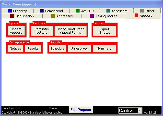
27 Appeals Tracks important dates related to appeals Produces pre-filled appeal application Produces pre-filled exemption request Provides a history of appeal results
28

29 Property List Builder Save and build lists of properties based on a variety of criteria Lists can be exported to several report formats and Excel Actions may be performed against an entire list o Deeds o Easements o Recalculating assessment values
30
31
32
33
Bldg Name: State Use: 1090 Vision ID: 2422 Account # 07Average RES LAND 109,100 DUXBURY, MA Total 1,522,000 1,522,000 RECORD OF OWNERSHIP
 Bldg #: Card Print Date: //8 : CURRENT OWNER el TOPO. Description -- UTILITIES STRT./ROAD LOCATION CURRENT ASSESSMENT Water Arterial Description Code Appraised Value Assessed Value 8No Sewer Paved,88,4,88,4
Bldg Name: State Use: 101 Vision ID: 2381 Account # 5 Private Well 1 Paved Description Code Appraised Value Assessed Value Res Land.
 Property Location: QUINN RD MAP ID: / 32/ A/ / Bldg Name: State : Vision ID: 238 Account # Bldg #: Card Print Date: 6/2/28 3: cel 62 Sec #: CURRENT OWNER TOPO. UTILITIES STRT./ROAD LOCATION CURRENT ASSESSMENT
UNDERSTANDING YOUR PROPERTY RECORD CARD
 UNDERSTANDING YOUR PROPERTY RECORD CARD OBJECTIVE: At first glance, the real estate property assessment record card can be intimidating. There is a wealth of information that can be difficult to read and
03/01/ /01/2014. Trending. Trending. Prod. Factor. Depth Factor. Base Rate. Square Feet
 85-06-0-400-049.000-0 SWYGART HARRY & AVIS E L / E METTLER 1 / 415 ADMINISTRATIVE INFORMATION OWNERSHIP Tax ID 0090047000 Printed 09/09/2016 Card No. 1 of PARCEL NUMER TRANSFER OF OWNERSHIP 85-06-0-400-049.000-0
Portage County, Ohio - Property Record Card Parcel: Card: 1
 Portage County, Ohio - Property Record Card Parcel: 4-18---1- Card: 1 GENERAL PARCEL INFORMATION Owner HOHENSTEIN WILLIAM R JR Property Address 37 HOWE Mailing Address 9521 BASTILLE ST UNIT 23 FAIRFAX
Description Code Appraised Value Assessed Value THE 108 MATTAPOISETT NK ROAD N. Res Dwell. Res Land
 Bldg #: 3 Card 3 Print Date: /29/27 2:35 CURRENT OWNER TOPO. UTILITIES STRT./ROAD LOCATION CURRENT ASSESSMENT FIELD HORACE F III & KAREN J TRUS Appraised Value Assessed Value THE 8 MATTAPOISETT NK ROAD
Property Information. Date: 4/12/2016. Parcel ID: R Site Address: 81 N Olde Park Pl Eagle Warmest Regards,
 Property Information Date: 4/12/2016 Parcel ID: R4549500180 Site Address: 81 N Olde Park Pl Eagle 83616 Warmest Regards, The TitleOne Team TitleOne Corporation www.titleonecorp.com Notice: This report
Bldg Name: State Use: 108 Vision ID: 1950 UTILITIES STRT./ROAD LOCATION CURRENT ASSESSMENT RES EXCES. 259,960 CROMWELL, CT Additional Owners:
 Property Location: 6&8 PINEY RIDGE ROAD MAP ID: 3/ 47/ 3-/ / Bldg Name: State : 8 Vision ID: 9 Account # Bldg #: of 3 Sec #: of Card of 3 Print Date: /4/ 4: CURRENT OWNER el TOPO. UTILITIES STRT./ROAD
6041 E 40th St, Indianapolis, IN 46226
 ( M a i n : c N O L I C a r m R e a l 708-440 - E D r S ( 440 - ( 708 - PROPERTY REPORT P r e s e n t e d b y Charlene Gaard REALTOR W o rk : ( 317 ) 2149 M o b i l e : F a x : 317 ) 4779 h a rl e n e
C A M A...C A R D...(Hardwick Township.../...Warren County)
") C A M A...C A R D...(Hardwick Township.../...Warren County) *** Links:... Map Page Map Book Google Map Vital Geo GIS Map Deed Last Scanned http://www.munwebstor.us/maps219/page3.pdf http://www.municipalassessornj.com/publisher/mapbook/219/mapbook/index.html
C A M A...C A R D...(Hardwick Township.../...Warren County) *** Links:... Map Page Map Book Google Map Vital Geo GIS Map Deed Last Scanned http://www.munwebstor.us/maps219/page3.pdf http://www.municipalassessornj.com/publisher/mapbook/219/mapbook/index.html
OnePlace CMA User s Guide. Creating a CMA using the OnePlace CMA module.
 OnePlace CMA User s Guide Creating a CMA using the OnePlace CMA module. How to Find It Go to http://www.ouroneplace.net Choose My CMA CMA: Manage CMA Choose CMA. To create a new CMA, enter a name for the
PROPERTY TAX TIPS AND TRICKS
 PROPERTY TAX TIPS AND TRICKS Presented By: Vicki Chiasson & Wes Pogorzelski PROVEN GOVERNMENT TECHNOLOGY LEADERSHIP Enhanced Levy Calculation Tax levies take a long time to generate Corrections may require
PARID: JUR: 04 LOREN C. Tax Roll Delq Taxes 1ST Taxes 2ND Taxes Total RP_OH $0.00 $0.00 $0.00 $0.00
 PARID: 684080008400 JUR: 04 NBHD: 80500 ROLL: RP_OH 1216 8TH ST W Parcel Address 1216 W 8TH ST Unit Class R - RESIDENTIAL Land Use Code 510-510 Tax Roll RP_OH Neighborhood 80500 - ASHTABULA CITY Acres.174
Current Value. Building Data. Year Built Tax Status. Code Area Type Size A0 RIGHT OF WAY Acres H HOME SITE Living Area (Sq Ft)
") Property Report Generated on 10/21/14 at 10:48:45 10:49:10 AM Owner MILLER RUSSELL LAWRENCE ET AL 3491 S HAMILTON RD COLUMBUS OH 43232 If the above is incorrect please call 614-525-4663 Tax Bill Mailing
Property Report Generated on 10/21/14 at 10:48:45 10:49:10 AM Owner MILLER RUSSELL LAWRENCE ET AL 3491 S HAMILTON RD COLUMBUS OH 43232 If the above is incorrect please call 614-525-4663 Tax Bill Mailing
HENDERSON STEVE A 1220 DR MLK JR BLVD 430, Restaurant, Cafeteria or Bar PENDLETON AVE CORRID 1/2
 8----.-3 HENDERSON STEVE A 22 DR MLK JR BLVD 3, taurant, Cafeteria or Bar PENDLETON AVE CORRID 2 Parcel Number 8----.-3 Local Parcel Number 8-2-2 Tax ID: 8-2-2 Routing Number K-P Property Class 3 taurant,
435 Civic Center Dr, Augusta, ME 04330
 SELLER'S REPORT P r e s e n t e d b y John Conley REALTOR J o h n C o n l e y P A @ g m a i l. c o m Legend: Subject Property Public Record Your Comp Analysis $500,000 Last Edited: 5/18/2018 $117 Price
DECEMBER 22, 2015 AT 5:30 PM WORK SESSION AGENDA
 MONROE COUNTY COUNCIL Monroe County Courthouse Room 306 100 W Kirkwood Avenue Bloomington, IN 47404 Phone: (812) 349-7312 Fax: (812) 349-2982 Cheryl Munson, President Shelli Yoder, Vice President Ryan
Land. Effective Frontage. Effective Depth. Factor Base Rate Adjusted Rate Estimated Value Influence Factor Land Value. Acreage / Sq. Ft.
 Parcel Number 91539 County Marion, IN Township WAYNE Corporation District Plat Map Alt Parcel 49-5-36-17-6.-982 Property Class 463 Tax District 982 Neighborhood 9175671-9-175c-1 Ownership Name WESTWOOD
Marshall & Swift SwiftEstimator
 Program Reference Marshall & Swift SwiftEstimator Commercial Estimator Program June 2016 June 2016 SwiftEstimator - Commercial Estimator 2 - i 2016 CoreLogic, Inc. All Rights Reserved Worldwide. No part
2458 E Ivy St, Mesa, AZ 85213
 U S M R e a l 390 - R o a d B ( 4, 615 - SELLER'S REPORT P r e s e n t e d b y Richard Park REALTOR Arizona Real Estate License: SA027366000 W o rk : ( 602 ) 5384 F a x : R i c k @ R i c h a rd P a rk
Index Calculating Total Living Area...2 Factors that affect your square footage:...3 Elements of the Property Sketch...4 Style Definitions...
 Index Calculating Total Living Area...2 Factors that affect your square footage:...3 Elements of the Property Sketch...4 Style Definitions...6 Ranch:... 6 Raised Ranch:... 7 Split Level:... 8 Cape Cod:...
2746 Travis Ave Fort Worth, TX 76110
 Call Stepping Stone Realty for more info or to schedule an appointment at 817.279.2804 Property Information *ARV: $29,000 SQFT: 2800 Investor s Cost: $16,000 BDRM/BATH: /1.5 Rehab Estimate: $60,000 Year
$174,900 Firm: 1015 Agt: 30847
 Customer Display RS 398829A 221 Hamby Lane, Mountain City TN 37683 County: JOHNSON Area: 316 - Mtn. City/ Johnson County Subdiv: na Unit: Rooms: 8 Yr Built: 2000 Bdrms: 4 Fireplc: Baths: 2 Acres: 2 Half
User Manual. Section 2: Implementation and Industry Translations. Created: October Copyright PropertyBoss Solutions, LLC. All Rights Reserved.
 User Manual Section 2: Implementation and Industry Translations Created: October 2010 Copyright PropertyBoss Solutions, LLC. All Rights Reserved. PropertyBoss Manual Section 2 - Implementation and Industry
Stone House & Barn on 1+ Acres in Upper Merion Twp, PA 326 King of Prussia Road, Wayne, PA 19087
 Stone House & Barn on 1+ Acres in Upper Merion Twp, PA 326 King of Prussia Road, Wayne, PA 19087 Preview: Wednesday, October 3 & 10 from 4-6 PM ET Auction Date: Monday, October 15 at 4:00 PM ET Auction
2-4 UNIT RESIDENTIAL APPRAISAL REPORT
 2-4 UNIT RESIDENTIAL APPRAISAL REPORT SUBJECT ASSIGNMENT MARKET AREA DESCRIPTION : : Cincinnati State: OH Zip Code: 45229 County: Hamilton Legal Description: 709 S CRESCENT AVE 50 X 250 PT LOT 29 S CLOONS
Data For Parcel N
 Data For Parcel N44-100300 Base Data Parcel: N44-100300 Tax Mailing Address Tax Mailing Name: TIPP CITY PROPERTIES LLC City State Zip: PIQUA OH 45356 Owner Address Owner Name: TIPP CITY PROPERTIES LLC
Preble County, Ohio - Property Record Card, Page 1 Parcel: C
 Preble County, Ohio - Property Record Card, Page 1 GENERAL PARCEL INFORMATION Owner Property Address Mailing Address Land Use Description 649 GREENBUSH RD PO BOX 13 WEST ELKTON OH 457 511 RESIDENTIAL DWELLING
Homeowner s Exemption (HOE)
") Homeowner s Exemption (HOE) Table of Contents CHEAT SHEETS... 3 Add HOE to a Parcel...3 Edit HOE Record...3 Remove HOE from a Parcel...3 Find the HOE Amount...3 Who is getting the exemption?...4 New Application
Homeowner s Exemption (HOE) Table of Contents CHEAT SHEETS... 3 Add HOE to a Parcel...3 Edit HOE Record...3 Remove HOE from a Parcel...3 Find the HOE Amount...3 Who is getting the exemption?...4 New Application
Pickens County Reassessment Program. Utilizing CAMA GIS MLS SQL
 1 Pickens County 2019 Reassessment Program Utilizing CAMA GIS MLS SQL Pickens County Reassessment History 1980 Countywide Reappraisal 1990 Countywide Reappraisal 1999 Countywide Reappraisal 2004 Countywide
2015 Routt County - Board of County Commissioners (BCC) Hearing Abatement Response
 Hearing Abatement Response") Office of the Routt County Assessor BCC Hearing Appraiser Recommendation Petitioner: Account #: 2015 Routt County - Board of County Commissioners (BCC) Hearing Abatement Response TRAILHEAD EVER GLORY,
Office of the Routt County Assessor BCC Hearing Appraiser Recommendation Petitioner: Account #: 2015 Routt County - Board of County Commissioners (BCC) Hearing Abatement Response TRAILHEAD EVER GLORY,
EXTERIOR APPRAISAL OF A TWO FAMILY HOUSE
 Form GA1V - "TOTAL" appraisal software by a la mode, inc. - 1-800-ALAMODE EXTERIOR APPRAISAL OF A TWO FAMILY HOUSE LOCATED AT -6118 Volume 8558 page 216 FOR William W. Ward, Esq 1318 Bedford St Stamford,
Calc. 588, ,000-4, MAINE ST, STE 401. Farm Land (Year) Open Space(Year) 5.Marsh/Bog 6.Ledge PT 6.SPRING 8.OTHER.
 Open Space(Year) 5.Marsh/Bog 6.Ledge PT 6.SPRING 8.OTHER.") Map Lot 34-1 Account 754 Location DECKER HILL ROAD Card 1 Of 1 2/19/217 THE NATURE CONSERVANCY OF THE PINE TREE STATE Property Data Assessment Record a/k/a BASIN PRESERVE Neighborhood 7 MEADOWBROOK Year
Map Lot 34-1 Account 754 Location DECKER HILL ROAD Card 1 Of 1 2/19/217 THE NATURE CONSERVANCY OF THE PINE TREE STATE Property Data Assessment Record a/k/a BASIN PRESERVE Neighborhood 7 MEADOWBROOK Year
Over the years CAMA has had many modifications and enhancements. Below is the current version.
 9/2016 Over the years CAMA has had many modifications and enhancements. Below is the current version. This is the newest version. Bigger screen with larger defined buttons. We ve added a couple of new
Bldg Name: State Use: 1090 Vision ID: 39 Account #
 Bldg #: 1 of 3 Sec #: 1 of 1 Card 1 of 3 Print Date: 11/27/218 8:48 CURRENT OWNER TOPO. UTILITIES STRT./ROAD LOCATION CURRENT ASSESSMENT Appraised Value Assessed Value CONWAY ERIN R 1,681,8 1,681,8 6 6
RES LAND 172,500 RAYNHAM, MA , 101. Total 7,331,300 7,331,300 BK-VOL/PAGE SALE DATE q/u v/i SALE PRICE V.C. PREVIOUS ASSESSMENTS (HISTORY)
") Property Location: CONNO AVE MAP ID:3/ 99/ / / State :2C Vision ID: 22 Account # 399 Bldg #: of 4 Sec #: of Card of 4 Print Date:/24/2 7: CURRENT OWNER TOPO. UTILITIES STRT./ROAD LOCATION CURRENT ASSESSMENT
Property Location: CONNO AVE MAP ID:3/ 99/ / / State :2C Vision ID: 22 Account # 399 Bldg #: of 4 Sec #: of Card of 4 Print Date:/24/2 7: CURRENT OWNER TOPO. UTILITIES STRT./ROAD LOCATION CURRENT ASSESSMENT
Retail Or Industrial Land For Sale
 Retail Or Industrial Land For Sale 345 /2 Newfield St. (Rt 3), Middletown, Ct 8.3 Acres (Includes Brick Ranch & Barns) & Tuttle Rd 2 Parcels With Double Access On Newfield St. (5.6 Acres)& Tuttle Rd. (2.65
Accounts in Brazoria County have two primary Identification numbers. The two forms of Identification are as follows:
 Accounts in Brazoria County have two primary Identification numbers. The two forms of Identification are as follows: Property ID: This is a six digit number that is generated sequentially as accounts are
Understanding the Clean and Green Program
 Understanding the Clean and Green Program Perry County, Pennsylvania DISCLAIMER: The material contained in this document is intended to provide only general information concerning the Pennsylvania Farmland
VISION Historic Dis GIS ID: 22-33
 Property Location: 6 SOUTH ST MAP ID: 22/ / 33/ / ldg Name: State : ldg #: of 4 Sec #: of Card of 4 Print Date: /26/22 23:44 CURRENT OWNER TOPO. UTILITIES STRT./ROAD LOCATION CURRENT ASSESSMENT ERERIAN
COMMERCIAL/INDUSTRIAL SALE Data Input Form MICHRIC, LLC (All Required Fields in Gray)
") MLS # Assigned by Computer Office ID: Agent ID: Co-Office ID: Co-Agent ID: Mailing Address: Street # Modifier: Direction: Street Name: Suffix: Unit #: Post Direction: County Name: City: State: Zip Code:
MLS # Assigned by Computer Office ID: Agent ID: Co-Office ID: Co-Agent ID: Mailing Address: Street # Modifier: Direction: Street Name: Suffix: Unit #: Post Direction: County Name: City: State: Zip Code:
Features Guide. Enhancements. Mortgage Calculators VERSION 7. May 2008
 Features Guide VERSION 7 May 2008 Copyright 2002-2008 SuperTech Software All rights reserved. Printed in Australia. Enhancements This document describes new features and enhancements in POSH. Mortgage
VISION DV Map # GIS ID:
 Property Location: 36 BERLIN ROAD MAP ID: / / 7B/ / Bldg Name: State : Bldg #: 4 Card 4 Print Date: 9/6/6 :57 el 94 Sec #: CURRENT OWNER TOPO. UTILITIES STRT./ROAD LOCATION CURRENT ASSESSMENT Public Water
Forest Hill Neighborhood
 M a i n : S c ( www. 464 - A MARKET ACTIVITY REPORT P r e s e n t e d b y Janet and Carole Scaralia Rhode Island Real Estate License: S17065 O ffi c e : A g e n t : 401 ) 6464 a ra l i a G ro u p @ g m
Introduction to CREST EDG Reports
 9 Introduction to CREST EDG Reports Introduction to CREST EDG Reports Overview Action Items Reports Report Formats Types of CREST EDG Reports CREST EDG produces many types of reports that help you to
Clean and Green LEBANON COUNTY UNDERSTANDING THE PROGRAM
 LEBANON COUNTY UNDERSTANDING THE Clean and Green PROGRAM When a county implements a Clean and Green program, it places two values on each parcel of land that qualifies. These values are known as the Fair
PEABODY COMMERCIAL PROPERTY RECORD CARD. Situs : 18 CROWNINSHIELD ST Map ID: A Class: Apartments - More than Eight Un
 7 Situs : 8 CROWNINSHIELD ST Map ID: 74-65A Class: s - More than Eight Un CURRENT OWNER CROWNINSHIELD APARTMENT ASSOC % STUART COMINS MANAGER 8 CROWNINSHIELD ST MA 96 Property Notes GENERAL INFORMATION
IAS 4.0 Cost & Income Valuation Guide
 IAS 4.0 Cost & Income Valuation Guide TABLE OF CONTENTS PREFACE... 1 ASSESSMENT ADMINISTRATION (AA) SCREENS RELATED TO VALUATION... 2 AA44 Jurisdiction Update...2 Overview... 2 To Query an Assessment Jurisdiction
Understanding. Clean and Green. Lycoming County Assessment Office 48 West Third Street Williamsport PA (570)
") Understanding Clean and Green Lycoming County Assessment Office 48 West Third Street Williamsport PA 17701 (570) 327-2301 DISCLAIMER: The material contained in this booklet is intended to provide only
Understanding Clean and Green Lycoming County Assessment Office 48 West Third Street Williamsport PA 17701 (570) 327-2301 DISCLAIMER: The material contained in this booklet is intended to provide only
BLAIR COUNTY. UNDERSTANDING THE Clean and Green PROGRAM. COUNTY OF BLAIR Blair County Courthouse 423 Allegheny Street Hollidaysburg, PA
 BLAIR COUNTY UNDERSTANDING THE Clean and Green PROGRAM When a county implements a Clean and Green program, it places two values on each parcel of land that qualifies. These values are known as the Fair
3737 Truett Blvd, Shreveport, LA 71107
 PROPERTY REPORT 3737 Truett Blvd, Shreveport, LA 71107 Presented by Carolyn and Cliff Grimsley Mobile: (318) 759-7636 Century 21 Elite 8575 Fern Avenue, Suite 105 Shreveport, LA 71105 3737 Truett Blvd,
COM LAND 62,600 MANSFIELD, MA ,700 Additional Owners: Other ID:
 Vision ID: 836 Account # 836 Bldg #: of 3 Sec #: of Card of 4 Print Date:/6/29 22:36 CURRENT OWNER TOPO. UTILITIES STRT./ROAD LOCATION CURRENT ASSESSMENT 4 Rolling 2 Public Water Paved Appraised Value
Understanding. Clean and Green
 Understanding Clean and Green Lycoming County Assessment Office 48 West Third Street Williamsport PA 17701 (570) 327-2301 DISCLAIMER: The material contained in this booklet is intended to provide only
4005 Guilford Ave, Indianapolis, IN 46205
 M a i n : g a a rd ro b e rt 317 - c 317 - PROPERTY REPORT W o rk : 317-440 - 2149 M o b i l e : P r e s e n t e d b y Robert Gaard REALTOR Indiana Real Estate License: RB17001433 @ g m a i l. c o m O
Bldg #: 1 of 1 Sec #: 1 of 1 Card 1 of 1 Print Date: 11/06/ :31 ld i ti UTILITIES STRT./ROAD LOCATION CURRENT ASSESSMENT HANOVER, TOWN OF
 Property Location: GREENSBORO RD MAP ID: 5/ 8/ / / Bldg Name: State Use: 93R Vision ID: 779 Account # Bldg #: of Sec #: of Card of Print Date: /6/4 7:3 CURRENT OWNER TOPO. ld i ti UTILITIES STRT./ROAD
Clermont County, Ohio 2014 Reappraisal and Tax Information
 As County Auditor, I am required by Ohio law to reappraise real property every six years and 2014 is the year we are mandated to revalue your property. The primary purpose of a reappraisal is to set the
MMSVP Migration Wizard
 MMSVP Migration Wizard Questions? From within BS&A, go to Help>Contact Customer Support and select Request Support Phone Call or Email Support. Or, you may call us at (855) 272-7638 and ask for the appropriate
Current Value. Building Data. Year Built Tax Status
 Property Report Generated on 11/07/14 at 05:58:34 05:58:38 PM Owner SHOEMAKER KEN 9020 STATE ROUTE 736 PLAIN CITY OH 43064 If the above is incorrect please call 614-525-4663 Tax Bill Mailing Info KEN SHOEMAKER
TOWN OF SKOWHEGAN, MAINE NOTICE OF FORECLOSURE SALE
 TOWN OF SKOWHEGAN, MAINE NOTICE OF FORECLOSURE SALE The Board of Selectmen of the Town of Skowhegan is accepting bids for the purchase of the municipality s interest in three (3) tax-acquired properties.
Bldg Name: State Use: 1090 Vision ID: 1790 Account #
 Bldg #: of 3 Sec #: of Card of 3 Print Date: /27/28 3:25 CURRENT OWNER TOPO. UTILITIES STRT./ROAD LOCATION CURRENT ASSESSMENT Appraised Value Assessed Value 269,4 269,4 36 85 CYPRESS ST RES LAND TISBURY,
Property Appraisal in Texas
 Property Appraisal in Texas What property is appraised? Land Structures (also called improvements ) Personal property (FOR BUSINESSES ONLY) What gives value to land? Size (Price per acre or square foot)
KINGSTON ASSESSING OFFICE
 Map: 0000U4 Lot: 000218 Sub: 000000 Card: 1 of 1 4 TWELFTH ST KINGSTON OWNER INFORMATION SALES HISTORY BENNET, HARRY Date Book Page Type Price Grantor 08/19/2009 5043 2950 U I 51 67,000 FEDERAL HOME LOAN
Data For Parcel
 Data For Parcel 1700143401 Base Data Parcel: 1700143401 Mailing Address Mailing Name: STRODE TONY E & SHARI J Address: P O BOX 392 City State Zip: BEVERLY OH 45715 Geographic City: UNINCORPORATED Township:
MASS APPRAISAL- REVALUATION PLAN BRULE COUNTY, SD ASSESSOR YEARS
 MASS APPRAISAL- REVALUATION PLAN BRULE COUNTY, SD ASSESSOR YEARS 2013-2017 5/5/5 Rotation to Follow 5/5/5 explained and outlined on last page Prepared 10/01/2013 Amended 10/15/2014 ESCALATED TIMELINE WAS
byv 46/i/ti Frank Lara, Principal Inspector Vacant Building Abatement CITY OF LOS ANGELES CALIFORNIA ERIC GARCETTI August 07, 2014
 BOARD OF BUILDING AND SAFETY COMMISSIONERS VAN AMBATIELOS PRESIDENT E. FELICIA BRANNON VICE-PRESIDENT JOSELYN GEAGA-ROSENTHAL GEORGE HOVAGUIMIAN JAVIER NUNEZ CITY OF LOS ANGELES CALIFORNIA ERIC GARCETTI
Sales Date Grantor Convey No. Convey Typ # Parcels Sales Price
 Owner Name ROMAN APOSTOLIC CHURCH INCORPORATION Prop. Class Land Use E - Exempt 685 - EXEMPT PROPERTY OWNE Site Address LegalDescriptions 3550 E DESHLER AV 3840 DESHLER AVE BEXLEY VIEW ACRES LOT 2 & 66.67'ES
FAIRA TRANSPARENCY REPORTS. 463 N Beach Dr, Port Ludlow, WA 98365
 608 State St. South Kirkland, WA 98033 www.faira.com hello@faira.com +1.800.571.FAIR Thank you for your interest in this Faira Certified home. FAIRA TRANSPARENCY REPORTS 463 N Beach Dr, Port Ludlow, WA
UNDERSTANDING PROPERTY TAXES IN COLORADO
 UNDERSTANDING PROPERTY TAXES IN COLORADO This brochure was created to provide general information on the Colorado property tax system. For more specific information on any one of these topics, please visit
RPR For Your Business
 RPR For Your Business What is RPR? RPR (Realtors Property Resource) is a member benefit from the National Association of REALTORS and is provided to you at no additional charge. Logging in RPR is in our
FOR SALE W. Broad Street, Columbus, Ohio 43204
 FOR SALE 3225 W. Broad Street, Columbus, Ohio 43204 3,440 Sq. Ft. Office Building on 0.132-Acre Parcel of Land. Currently Subdivided into 6 Office Suites. Short Term Leases Can Accommodate an Owner Occupant
COM LAND 44,200 MANSFIELD, MA BK-VOL/PAGE SALE DATE q/u v/i SALE PRICE V.C. PREVIOUS ASSESSMENTS (HISTORY) 75/ 33
 75/ 33") Property ocation: 3 WINTHROP AVE MAP ID:2/ 9/ / / State :3 Vision ID: 78 Account # 78 Bldg #: of 3 Sec #: of Card of 3 Print Date:/27/27 4:2 CURRENT OWNER TOPO. UTIITIES STRT./ROAD OCATION CURRENT ASSESSMENT
Property ocation: 3 WINTHROP AVE MAP ID:2/ 9/ / / State :3 Vision ID: 78 Account # 78 Bldg #: of 3 Sec #: of Card of 3 Print Date:/27/27 4:2 CURRENT OWNER TOPO. UTIITIES STRT./ROAD OCATION CURRENT ASSESSMENT
A Guide Tax Assessment. George M. Durgin Middletown Tax Assessor August 4, 2016
 A Guide Tax Assessment George M. Durgin Middletown Tax Assessor August 4, 2016 A Guide to Tax Assessment Legal Basis Valuation Land Value Building Value Appeal Process Legal Basis Rhode Island General
PROPERTY QUICK FACTS
 PROPERTY QUICK FACTS Property Type: Location: Herbie s Bar & Chowder House 635 Overseas Highway Marathon, Florida 335 Alternate Key #: 141442 Parcel ID #: 33638-217 Tax Bill: $7,791.95 Site Size SF: Building
Date: March 2018 TOWN OF WATERFORD Department of Assessment
 Date: March 2018 TOWN OF WATERFORD 1. Overview: The purpose of this workshop is to explain the Assessment Disclosure Notice, how assessments are derived and how to challenge your assessment if you do not
Full CMA. Cover Page Tab
 CMA A Comparable Market Analysis (CMA) is a comparison between properties that are like a property you re trying to sell. A CMA is used in pricing a property you compare the property you re trying to sell
PROPERTY INFORMATION PACKAGE #
 PROPERTY INFORMATION PACKAGE # 11-1320 Mortgagee s Foreclosure AUCTION 2,153+/-SF SINGLE FAMILY HOME ON.15+/- ACRES 3 Bedroom, 1.5 Bath ~ Detached 2-Car Garage 49 RAVINE RD., MEDFORD, MA Tuesday, April
MLS # Date DOM Price
 MLS # 71276727 - New Single Family - Detached 34 Woodland Ave List Price: $325,000 Milford, MA 01757-3542 Worcester County Style: Colonial Color: Plum Total Rooms: 9 Bedrooms: 4 Full/Half/Master Baths:
7/26/2016
 TerraScan MapSifter - Adams County Washington - Print Page Page 1 of 1 Parcels Parcel 2100490730100 Owner ELDRIDGE, TANIS MARIE Situs 766 S THACKER RD http://adamswa.mapsifter.com/print/landscape.aspx?key=06e1bbf12ed34f2eaa779965491...
About This Report. Risk Id: 32 NC
 About This Report The Building Overview Report delivers key building characteristics, scored for accuracy based on Verisk analytics, along with photos and aerial imagery of the building, and other important
1869 MISTY MOON WAY Town of Lawrence, WI R Active. List: $194,900
 R 50027847 Active 1869 MISTY MOON WAY Town of Lawrence, WI 54115 List: $194,900 Firm: 2694 Off: 0 Agt: 109059 Finished Bedrooms 4 Finished Full Baths: 3 Finished Half Baths: 0 MLS Area: 111 / GB/FV-SWest
8 Units in Salinas. 539 Terrace Dr Salinas, CA List Price: $750,000
 For more information contact: Apartment / Investment Broker michael@svmultifamily.com BRE 01327546 List Price: $750,000 Property Refurbished in 2006 with Numerous Upgrades: Roof, plumbing, kitchens, bathrooms,
CMA "Price It Right"- Matrix
 CMA "Price It Right"- Matrix Houston Association of Realtors 3 Hours CE Course#: 3160 2 Table of Contents 1. Overview 3 2. Subject Property Information 3 3. Selecting Comparables (Comps) 5 4. History Report
FOR SALE 2 INDUSTRIAL BUILDINGS
 FOR SALE 2 INDUSTRIAL BUILDINGS 10 ALDRICH AVE and/or 24 ALDRICH AVE. - NORWAY, ME 10 ALDRICH AVE 24 ALDRICH AVE RARE OPPORTUNITY IN OXFORD COUNTY 2 INDUSTRIAL BUILDINGS FOR SALE Can be sold separately
Understanding the Clean and Green Program
 Understanding the Clean and Green Program Venango County, Pennsylvania DISCLAIMER: The material contained in this booklet is intended to provide only general information concerning the Pennsylvania Farmland
Single Family Property Information for Listing Fax
 Single Family Property Information for Listing www.presmanrealty.com info@presmanrealty.com 224-365-5681 Fax 877-233-6003 Date: List Price: Address: City, State and zip: County: Township: Corporate or
105 parkway drive - unit c lease
 105 parkway drive - unit c lease table of contents section I property brochure & market data property flyer additional photos section II property maps location map aerial imagery map survey standard site
Appraisal Firewall Quick Start Guide
 Appraisal Firewall Quick Start Guide Information for Manager Users BASIC USAGE AND LAYOUT... 2 MANAGER SETTINGS... 3 ORDERS... 5 PINNED ORDERS... 6 WORKING IN AN ORDER... 7 RELATIONSHIPS... 9 LENDERS TAB...
Georgia Department of Revenue. WinGAP. Georgia CAMA Software
 WinGAP Georgia CAMA Software Presenter Tracy Thomas Business Operations Specialist Georgia Department of Revenue Local Government Services tracy.thomas@dor.ga.gov Public Utility Appraisal Eight DOR field
COMMERCIAL OPPORTUNITY. Schmitt Real Estate Co Overseas Highway, Tavernier, FL. Brian c. schmitt. Features: Year Built:
 COMMERCIAL OPPORTUNITY 91731 Overseas Highway, Tavernier, FL Features: Location: Space: Year Built: Taxes: Price: MLS#: Schmitt Real Estate Co. Commercial property for sale with 150' on US1 and 95' on
Property Information Package
 Property Information Package 1.641± Acres Zoned Commercial on Hwy 128 in Savannah, TN Selling in 2 Tracts (2) Aerial Map 1 Plat 2 Title Commitment 3 Traffic Info Station North of Property 6 Traffic Info
Property Tax Fairness and the Future of Further Reform
 Property Tax Fairness and the Future of Further Reform Ryan Kamrowski, Director of Tax Equalization, Ward County Senator Dwight Cook, Mandan (Dist. 34) Donnell Preskey Hushka, Government Affairs Specialist,
STATEMENTS OF POLICY Title 7 AGRICULTURE
 3072 STATEMENTS OF POLICY Title 7 AGRICULTURE DEPARTMENT OF AGRICULTURE [7 PA. CODE CH. 137a] Clean and Green The Department of Agriculture (Department) gives notice of the interim regulations for implementing
ADDENDUM #2_RFP # Computer Mass Appraisal (CAMA) Software for HC Assessor Department
 Software for HC Assessor Department") Horry County Government PROCUREMENT DEPARTMENT www.horrycounty.org Horry County Office of Procurement 3230 Hwy. 319 E. Conway, South Carolina 29526 Phone 843.915.5380 Fax 843.365.9861 TO: FROM: ALL INTERESTED
Horry County Government PROCUREMENT DEPARTMENT www.horrycounty.org Horry County Office of Procurement 3230 Hwy. 319 E. Conway, South Carolina 29526 Phone 843.915.5380 Fax 843.365.9861 TO: FROM: ALL INTERESTED
QUESTIONNAIRE. 1. Authorizing statute(s) citation West Virginia Code and 11-1C-4(d)
 citation West Virginia Code and 11-1C-4(d)") QUESTIONNAIRE (Please include a copy of this form with each filing of your rule: Notice of Public Hearing or Comment Period; Proposed Rule, and if needed, Emergency and Modified Rule.) DATE: 6/8/15 TO:
QUESTIONNAIRE (Please include a copy of this form with each filing of your rule: Notice of Public Hearing or Comment Period; Proposed Rule, and if needed, Emergency and Modified Rule.) DATE: 6/8/15 TO:
TREASURER S DEPARTMENT
 TREASURER S DEPARTMENT ORGANIZATIONAL CHART COUNTY TREASURER ADMINISTRATION SERVICE TO PUBLIC SERVICE TO COUNTY DEPARTMENTS SERVICE TO COUNTY GOV T DEPARTMENT DESCRIPTION The Treasurer s Office is a mandated
480-a. Taxation of forest land. 1. As used in this section:
 480-a. Taxation of forest land. 1. As used in this section: (a) " Approved management plan " shall mean a plan approved by the department for the management of an eligible tract which shall contain requirements
The Department s Role
 CITY ASSESSOR The Department s Role on the h Ci City s T Team August 21, 2013 Who we are... Micheal Lohmeier City Assessor (2012) (Commercial Appraiser 1998-2005, Assr. 2010-12) 12) Administration and
ASSESSOR'S OFFICE I. DEPARTMENT MISSION OR MANDATE OR GOAL
 ASSESSOR'S OFFICE I. DEPARTMENT MISSION OR MANDATE OR GOAL The purpose of the Assessor's Office is to produce a timely roll of all property subject to local assessment; administer legally permissible exemptions;
Cadastral services and virtual office in e-cadastre
 Cadastral services and virtual office in e-cadastre Priit Kuus Estonian Land Board October 26, 2016 Coimbra Scope of data Cadastral parcels (as of September 2016) 674 383 cadastral parcels, i.e. 97,7 %
MIFFLIN COUNTY APPLICATION FOR USE VALUE ASSESSMENT OF LAND FOR REAL ESTATE TAX PURPOSES UNDER ACT 391 OF 1974 & ACT 156 OF 1998 CLEAN & GREEN
 MIFFLIN COUNTY APPLICATION FOR USE VALUE ASSESSMENT OF LAND FOR REAL ESTATE TAX PURPOSES UNDER ACT 391 OF 1974 & ACT 156 OF 1998 CLEAN & GREEN The following conditions must be met before the Assessment