Georgia Department of Revenue. WinGAP. Georgia CAMA Software
|
|
|
- Shanon Thomasine Thornton
- 5 years ago
- Views:
Transcription
1 WinGAP Georgia CAMA Software
2 Presenter Tracy Thomas Business Operations Specialist Georgia Department of Revenue Local Government Services

3 Public Utility Appraisal Eight DOR field agents / appraisers are responsible for the location, identification and appraisal of Public Utility owned real estate.

4 Public Utility Appraisal Operating Property Unit Valuation Non-Operating Property Summation Valuation
5 Before WinGAP Paper Property Record Cards Develop / Print photos Tape photos to PRC cards Photo Copy PRC for field book held by field agent

")
6 Parcels were located on State DOT maps, County Index Maps and/or Road ATLAS books (metro) Before WinGAP
7 Company Return To DOR DOR agents reconcile Reconciliation Report Mailed / delivered back to DOR
8 Before WinGAP Process worked but was not terribly efficient as all appraisal, location, documentation, and communication of valuations back to Atlanta was entirely manual.
9 The Battle Begins Senior field agents had developed the manual process and it was working, despite its inefficiencies Younger field agents, a bit more technology savvy, saw a better way Change is never easy

10 The breaking points: Tipping Point DOR devoted resources to this CAMA system for usage by county appraisers in WinGAP

11 WinGAP Arrives
12 WinGAP Design Advantages Application does require complex Windows system installs App will run with simple copy/paste of file directory contents Database is simple, efficient, and very manageable with minimum DBA Geographic Information Systems had evolved to be more user friendly and compatible.
13 Configuration Application loaded on local notebook for each field appraiser Data Subdirectories exist on local notebook creating a simple and efficient container for all files related to each county s PU property

14 Application easily switches between county PU data Configuration

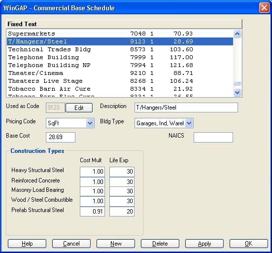
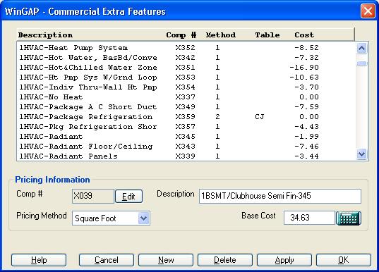
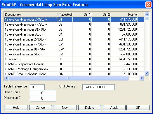
15 WinGAP Features Allows complete flexibility in creation of valuation models Appraisers can create their own models and supply valuation info
16
17
18

19 WinGAP Features Complete control over descriptive characteristics
20

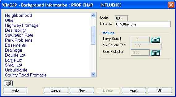
21 WinGAP Features Up to seven customized parcel influences
22


23 WinGAP Features Software is extremely easy to operate
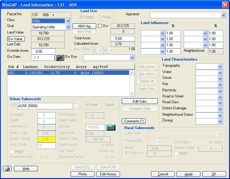
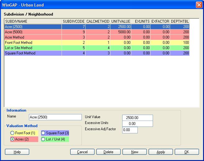
24
25
26


27
28 WinGAP Features A simple yet elegant drawing mechanism is in place to draw building footprints
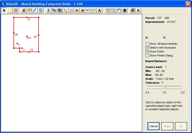
29
30 WinGAP Features Application allows us to digitally store and maintain photos for Land Residential Commercial Accessory / Miscellaneous Personal Property Items / Assets
31
32 WinGAP Features WinGAP allows DOR appraisers to create variety of valuation models for the appraisal of any type of land including PU lake lots.
33
34
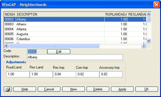
35 Neighborhood Adjustments
36 WinGAP Features Property location assistant Company provided E-911 street address entered into WinGAP allows usage of MAP-IT button which locates the parcel on Google Maps

37 Data Export Export to Excel just a few clicks away

38 Data Sharing Field agents can now electronically share WinGAP CAMA data with Atlanta office.

39 Computerization has vastly expanded reporting and query options Reporting

40 Exception Reports Appraisal Reports Property Record Cards Return Processing Reporting

41 Prebuilt Reports

42 Report Builder
43 WinGAP has allowed us to go totally paperless Edits that once required paper are now made in electronic documents Go Green
44

45 GIS introduces even more data capabilities Tax Districts Value considerations

46 Google Earth WinGAP GPS Parcel positions
47 Company Return To DOR DOR agents reconcile Reconciliation Report Mailed / delivered back to DOR


48 Company Return To DOR DOR agents reconcile Reconciliation Report delivered back to DOR
49 System Integration Agent uploads completed data to DOR servers Oracle systems on centralized server imports WinGAP CAMA data

50
51
52


53 What s next WinGAP moving to SQL Server 2008 Enhanced GIS Applications

54 Questions?
GIS & Mobile Technology: It s Not Just For Real Property Tangible Technology for Tangible Personal Property Valuation
 GIS & Mobile Technology: It s Not Just For Real Property Tangible Technology for Tangible Personal Property Valuation Steve Weissman, RES, CFE, MBA Manager, Personal Property Appraisal Section Palm Beach
Assessor. Mission Statement: Functions: Long Term Goals: Page 1 of 6
 Assessor Mission Statement: The mission of the Assessor s Office is to create accurate, equitable, and timely property tax assessments to fund public services; and to be a source of current, accurate property
Cloud GIS Real Estate Management, Appraisal and Development Service USING ESRIs ARCGIS SERVER
 Cloud GIS Real Estate Management, Appraisal and Development Service USING ESRIs ARCGIS SERVER INFODIM: Was founded on 1992 and is internationally certified as a GIS company from D&B Dun & Bradstreet Global
Directorate of Survey and Mapping NAMIBIA. Cadastral Information System. Vehupisa Kasuko Tjatindi Surveyor Directorate of Survey and Mapping NAMIBIA
 Vehupisa Kasuko Tjatindi Directorate of Survey and Mapping NAMIBIA Tel: +64 61 965000 Directorate of Survey and Mapping NAMIBIA Cadastral Information System Introduction Over the past few decades cadastral
HOW TO CREATE AN APPRAISAL
 Page 1 7/19/2005 IMAGEsoft s Appraise Link Instruction Manual HOW TO CREATE AN APPRAISAL Start at the MAIN MENU. Click on APPRAISALS. The WORK WITH APPRAISALS screen appears. This screen stores your appraisals,
New Models for Property Data Verification and Valuation
 New Models for Property Data Verification and Valuation for 2006 IAAO Councils and Sections Joint Seminar May 9-11, 2006 Charleston, South Carolina Presented by George Donatello, CMS Principal Consultant
Reports. Martin Barrett Software Developer 8 Years
 Reports Martin Barrett Software Developer 8 Years 4-19-17 Vanguard Appraisals, Inc. Copyright 2017 Report Changes About me Report Changes New Reports Easy Mode Important Reminders Report Errors Explained
Fit-for Purpose Approaches to Land Administration
 Fit-for Purpose Approaches to Land Administration Brent Jones, PE, PLS Global Manager, Casastre/Land Records bjones@esri.com Land Administration GIS is the platform for land administration Land administration
2018 Assessment Roll Edit Guide for Parcel-Level Geographical Information System (GIS) Information
 Information") 2018 Assessment Roll Edit Guide for Parcel-Level Geographical Information System (GIS) Information Florida Department of Revenue Property Tax Oversight January 2, 2018 Intended Users This edit guide is
2018 Assessment Roll Edit Guide for Parcel-Level Geographical Information System (GIS) Information Florida Department of Revenue Property Tax Oversight January 2, 2018 Intended Users This edit guide is
Contents. & equitable. 16 Cover illustration by Chris Bennett and Daniel Anzaldi, RES FAIR. 3 Appraiser-Friendly GIS: Cover Story
 Contents AUGUST 2006 VOLUME 4. NUMBER 8 Cover Story 3 Appraiser-Friendly GIS: Keeping the Focus on the User by Daniel Anzaldi, RES Feature Article 7 A Partnership in Integration: The State of Wyoming and
Field surveying inspection using tablets
 Field surveying inspection using tablets Rami Farraj, Ahmad Sghyyer Survey of Israel, Lincoln 1, Tel-Aviv, Israel rami@mapi.gov.il ahmad@mapi.gov.il Key words: Field Surveying, Cadastre, Mapping Procedures
A Complete, Free Solution for Cadastral Map Management
 A Complete, Free Solution for Cadastral Map Management Gyula IVÁN Institute of Geodesy, Cartography & Remote Sensing (FÖMI) HUNGARY FIG Commission 7, Annual Meeting 11-15 September 2008., Verona, ITALY
Over the past several years, appraisers have made
 COVER STORY Collecting Parcel Data on Handheld Computers by Edgar Clodfelter, Randy Link, and Thomas E. Walker Over the past several years, appraisers have made great strides in applying computer technologies
University of Nairobi LAND INFORMATION SYSTEM FOR LAND MANAGEMENT IN KENYA. CASE STUDY: NAIROBI COUNTY, BURUBURU PHASE I ESTATE
 University of Nairobi LAND INFORMATION SYSTEM FOR LAND MANAGEMENT IN KENYA. CASE STUDY: NAIROBI COUNTY, BURUBURU PHASE I ESTATE BY Justus Amdavi F56/69371/2013 Supervisor: Mr Jasper Mwenda CONTENTS Introduction
LRIMS Cadastre Module
 LRIMS Cadastre Module User Requirements and Functionality (Seychelles Case Study) John Latham, NRL Renato Cumani, NRL Luigi Simeone, NRL Summary Background User Requirements Business Model Application
TREASURER S DEPARTMENT
 TREASURER S DEPARTMENT ORGANIZATIONAL CHART COUNTY TREASURER ADMINISTRATION SERVICE TO PUBLIC SERVICE TO COUNTY DEPARTMENTS SERVICE TO COUNTY GOV T DEPARTMENT DESCRIPTION The Treasurer s Office is a mandated
REQUEST FOR PROPOSAL FOR PROPERTY ASSESSMENT SERVICES FOR THE CITY OF BELOIT, WISCONSIN ISSUED SEPTEMBER 30, 2016
 REQUEST FOR PROPOSAL FOR PROPERTY ASSESSMENT SERVICES FOR THE CITY OF BELOIT, WISCONSIN ISSUED SEPTEMBER 30, 2016 DUE DATE: OCTOBER 28, 2016, 2:00 PM(CT) Table of Contents CITY OF BELOIT REQUEST FOR PROPOSAL
TREASURER S DEPARTMENT
 TREASURER S DEPARTMENT ORGANIZATIONAL CHART COUNTY TREASURER ADMINISTRATION SERVICE TO PUBLIC SERVICE TO COUNTY DEPARTMENTS SERVICE TO COUNTY GOV T DEPARTMENT DESCRIPTION The Treasurer s Office is a mandated
Modernizing Land Administration Systems
 Presented at the FIG Congress 2018, May 6-11, 2018 in Istanbul, Turkey Modernizing Land Administration Systems B r e n t J o n e s P E, PLS E s r i Land Administration Systems GIS is the Technology Platform
THE APPRAISAL OF REAL ESTATE 13TH EDITION PDF
 THE APPRAISAL OF REAL ESTATE 13TH EDITION PDF ==> Download: THE APPRAISAL OF REAL ESTATE 13TH EDITION PDF THE APPRAISAL OF REAL ESTATE 13TH EDITION PDF - Are you searching for The Appraisal Of Real Estate
Announcements. Texas State Genealogical Society Annual Conference October 20-22, 2017, Houston, Texas
 Announcements Dallas Genealogical Society General Meeting September 9, 2017 with David Passman http://dallasgenealogy.com/dgs/event/general-meeting-19/ DGS 2017 Fall Seminar D. Joshua Taylor: Resource
Conducts informal meetings with property owners during appeal season in reviewing property assessments and information in property file.
 VACANT POSITION DEPARTMENT: TAX ASSESSOR SUBMIT APPLICATION and PROOF OF EDUCATION TO: employment@spaldingcounty.com or to: HUMAN RESOURCES OFFICE CLOSING DATE: Position will remain open until filled Job
General Questions. What happens to my saved CMAs in my current program? Your saved CMAs, unfortunately, cannot be transferred over to Moxi Present.
 FAQs General Questions What is Moxi Present? Moxi Present is a powerful presentation and CMA tool that you can use to easily create professional, tech-savvy presentations that will impress clients and
MyCommunity Beautiful web sites and interactive portals for real estate communities
 MyCommunity Beautiful web sites and interactive portals for real estate communities Our simple idea To build a platform that hosts thousands of web sites and secure portals for apartment buildings, commercial
IBM TRIRIGA Version 10 Release 5.3. Lease and Owned Property Contract Management User Guide IBM
 IBM TRIRIGA Version 10 Release 5.3 Lease and Owned Property Contract Management User Guide IBM Note Before using this information and the product it supports, read the information in Notices on page 59.
2014 WinGAP Conference Al Deen and Tracy Thomas
 2014 WinGAP Conference Al Deen and Tracy Thomas Savannah, Georgia Marriott Riverfront Hotel September 25 th and 26 th, 2014 Introduction Tracy Thomas Georgia Department of Revenue, Business Analyst, 23
 Apostolos Arvanitis, Associate Professor Asterios Asteriadis, Rural - Surveying Engineer Thomai Sotireli, Rural - Surveying Engineer Aristotle University School of Rular and Surveying Engineering Department
Demonstration Appraisal Report Utilizing a Form Report
 Demonstration Appraisal Report Utilizing a Form Report National Association of Independent Fee Appraisers 330 North Wabash Avenue, Suite 2000 Chicago, IL 60611 Phone: (312) 321-6830 Fax: (312) 673-6652
GAUSSCAD A WEBGIS APPLICATION FOR COLLECTING CADASTRAL DATA
 M.M. Moise GaussCAD a WebGIS Application for Collecting Cadastral Data GAUSSCAD A WEBGIS APPLICATION FOR COLLECTING CADASTRAL DATA Mihai-Mircea MOISE, S.C. GAUSS S.R.L., mihai.moise@gauss.ro Abstract:
ADDENDUM #2_RFP # Computer Mass Appraisal (CAMA) Software for HC Assessor Department
 Software for HC Assessor Department") Horry County Government PROCUREMENT DEPARTMENT www.horrycounty.org Horry County Office of Procurement 3230 Hwy. 319 E. Conway, South Carolina 29526 Phone 843.915.5380 Fax 843.365.9861 TO: FROM: ALL INTERESTED
Horry County Government PROCUREMENT DEPARTMENT www.horrycounty.org Horry County Office of Procurement 3230 Hwy. 319 E. Conway, South Carolina 29526 Phone 843.915.5380 Fax 843.365.9861 TO: FROM: ALL INTERESTED
Office of the County Auditor. Broward County Property Appraiser Report on Transition Review Services
 Office of the County Auditor Broward County Property Appraiser Report on Transition Review Services January 14, 2005 Table of Contents BACKGROUND AND SCOPE...3 FINDINGS AND RECOMMENDATIONS...3 1. Financial
QUESTIONNAIRE. 1. Authorizing statute(s) citation West Virginia Code and 11-1C-4(d)
 citation West Virginia Code and 11-1C-4(d)") QUESTIONNAIRE (Please include a copy of this form with each filing of your rule: Notice of Public Hearing or Comment Period; Proposed Rule, and if needed, Emergency and Modified Rule.) DATE: 6/8/15 TO:
QUESTIONNAIRE (Please include a copy of this form with each filing of your rule: Notice of Public Hearing or Comment Period; Proposed Rule, and if needed, Emergency and Modified Rule.) DATE: 6/8/15 TO:
Marsha M. Faux, CFA, ASA Polk County Property Appraiser. A Tour of Our Website
 Marsha M. Faux, CFA, ASA Polk County Property Appraiser A Tour of Our Website 2017 www.polkpa.org Bartow Main Office 255 N Wilson Ave Bartow, FL 33830 Phone: 863-534-4777 Fax: 863-534-4753 Lakeland Branch
Country report, HUNGARY
 Country report, HUNGARY Gyula IVÁN Institute of Geodesy, Cartography & Remote Sensing (FÖMI) HUNGARY FIG Commission 7 Annual Meeting 2009 12-16 October, 2009, Kuala Lumpur, Malaysia Institute of Geodesy,
etrac Guide Enhanced Appraiser Scoring Global DMS, 1555 Bustard Road, Suite 300, Lansdale, PA , All Rights Reserved.
 etrac Guide to Enhanced Appraiser Scoring Version: 2.5.0 Published: 09/22/2014 Global DMS, 1555 Bustard Road, Suite 300, Lansdale, PA 19446 2014, All Rights Reserved. Table of Contents Introduction to
Working in the Appraisal Firewall Relationships Screen
 Working in the Appraisal Firewall Relationships Screen User Training Guide for Managers The Relationships window is your guide to manage your clients accounts, work within their orders, and oversee all
Features Guide. Enhancements. Mortgage Calculators VERSION 7. May 2008
 Features Guide VERSION 7 May 2008 Copyright 2002-2008 SuperTech Software All rights reserved. Printed in Australia. Enhancements This document describes new features and enhancements in POSH. Mortgage
NEW DEVELOPMENTS IN THE REAL PROPERTY REGISTER AND CADASTRE IN LITHUANIA
 NEW DEVELOPMENTS IN THE REAL PROPERTY REGISTER AND CADASTRE IN LITHUANIA Jaunius Grigas E-mail: jaunius.grigas@registrucentras.lt Verona, 2008 FUNCTIONS OF STATE ENTERPRISE CENTRE OF REGISTERS Registration
REQUEST FOR INFORMATION (RFI) from the Florida Dept. of Transportation
 from the Florida Dept. of Transportation") REQUEST FOR INFORMATION (RFI) from the Florida Dept. of Transportation The Department of Transportation, Office of District Four Procurement Office is requesting the following information from prospective
REQUEST FOR INFORMATION (RFI) from the Florida Dept. of Transportation The Department of Transportation, Office of District Four Procurement Office is requesting the following information from prospective
The principal tasks or competencies of the General Directorate of Cadastre are:
 4th Quality Conference 1/7 1) Title of the case. Spanish e Cadastre ( Virtual Office of Cadastre, or OVC). An open space for sustainable quality in cadastral data, working with land management administrations.
STEARNS APPRAISAL REQUEST SYSTEM - ARS
 HVCC HOME VALUATION CODE OF CONDUCT Due to the recent regulation passed in December 2008 by the Federal Housing Finance Agency (FHFA) new standards in relation to Appraisal Procedures must be followed.
IBM TRIRIGA Version 10 Release 5.1. Lease and Owned Property Contract Management User Guide IBM
 IBM TRIRIGA Version 10 Release 5.1 Lease and Owned Property Contract Management User Guide IBM Note Before using this information and the product it supports, read the information in Notices on page 61.
City of Lithonia Housing Inventory
 City of Lithonia Housing Inventory ARC Community Choices Program GPA Winner- Outstanding Initiative in a Small Community Housing Inventory Summary As part of the city s participation in the Georgia Initiative
Property Registration in Albania: An Information Management Issue
 No. 3 A L B A N I A S E R I E S September 1997 Property Registration in Albania: An Information Management Issue Romeo Sherko and Naim Sula PROPERTY REGISTRATION IN ALBANIA: AN INFORMATION MANAGEMENT ISSUE
DALLAS CENTRAL APPRAISAL DISTRICT DCAD VALUATION PROCESSES
 DALLAS CENTRAL APPRAISAL DISTRICT DCAD VALUATION PROCESSES DALLAS CENTRAL APPRAISAL DISTRICT DCAD DCAD appraisers appraise a large universe of properties by developing appraisal models DCAD appraisers
Land Administration and Spatial Enablement Victoria s Experience. Chris McRae, Executive Director Land Victoria
 Land Administration and Spatial Enablement Victoria s Experience Chris McRae, Executive Director Land Victoria 4 th UN Land Administration Forum, October 2011 Outline About Land Victoria Land Victoria
Six Steps to a Completed Appraisal Report
 Six Steps to a Completed Appraisal Report Section 1 DataLog - Comparable Sales Database ClickFORMS - Report Processor Section 2 Addenda Section 3 Mini Sample - Approach Pages 1 Six Steps to a Completed
Estonian e-cadastre as basis for efficient land management
 Estonian e-cadastre as basis for efficient land management Priit Kuus Estonian Land Board November 14, 2017 Tallinn Scope of data Cadastral parcels (as of October 2017) 693 026 cadastral parcels, i.e.
The Cadastral Template 2.0, From Design to Implementation
 Abbas RAJABIFARD (Australia), Daniel Steudler (Switzerland), Ali AIEN, and Mohsen KALANTARI, Australia Key words: Cadastral Template 2.0, Cadastral Template Project, Land Administration, PCGIAP SUMMARY
2015 Schedules of Values, Standards, and Rules. Melia Miller, Iredell County Tax Assessor
 2015 Schedules of Values, Standards, and Rules Melia Miller, Iredell County Tax Assessor 2015 Reappraisal G.S. 105-286 requires general revaluation of real property at least every eight years G.S 105-286(a)(3)
Appraiser II or Appraiser III / Tax Assessor's Office
 UNIFIED GOVERNMENT OF ATHENS-CLARKE COUNTY invites applications for the position of: Appraiser II or Appraiser III / Tax Assessor's Office SALARY: $38,348.00 - $55,813.00 Annually OPENING DATE: 09/21/18
Esri Middle East and Africa User Conference. December Abu Dhabi, UAE. Land Administration. Mark Baker
 Esri Middle East and Africa User Conference December 10 12 Abu Dhabi, UAE Land Administration Mark Baker Our Agenda 0900 0930 Welcome Mark Baker, Esri 0930 1030 New Directions The New Addressing System
Paperless e-surveying with Mr Laptop Surveyor
 Paperless e-surveying with Mr Laptop Surveyor RICHARD ABBOTT Bachelor of Technology (surveying) University Adelaide Licensed surveyor Consulting cadastral surveyor Presented on eve of 32nd year attaining
Collateral Underwriter Overview. National Association of REALTORS January 23, 2015
 Collateral Underwriter Overview National Association of REALTORS January 23, 2015 2014 Fannie Mae. Trademarks of Fannie Mae. Introduction to Collateral Underwriter I January 2015 What Is Collateral Underwriter?
CITY OF VERONA. Request for Proposals (RFP) Assessment Services For the Assessment Years
 Assessment Services For the Assessment Years") CITY OF VERONA Request for Proposals (RFP) Assessment Services For the Assessment Years 2019-2022 Due Date: December 28, 2018 by 4:30 p.m. Table of Contents DOCUMENT PAGE Background Information... 2 Specific
CITY OF VERONA Request for Proposals (RFP) Assessment Services For the Assessment Years 2019-2022 Due Date: December 28, 2018 by 4:30 p.m. Table of Contents DOCUMENT PAGE Background Information... 2 Specific
Demonstration Properties for the TAUREAN Residential Valuation System
 Demonstration Properties for the TAUREAN Residential Valuation System Taurean has provided a set of four sample subject properties to demonstrate many of the valuation system s features and capabilities.
The Newsletter of the Maine Chapter IAAO SPRING Covering Maine Assessing FROM THE EDITOR:
 Covering Maine Assessing The Newsletter of the Maine Chapter IAAO SPRING 2013 FROM THE EDITOR: Maine chapter iaao SPRING 2013 By Kyle Avila, CMA I use GIS daily for explaining valuations to taxpayers in
Taxpayer Guide. Pioneer Technology Group 110 Central Park Drive, Suite 200 Sanford, FL or Fax:
 Taxpayer Guide Pioneer Technology Group 110 Central Park Drive, Suite 200 Sanford, FL 32771 407.321.7434 or 1.800.280.5281 Fax: 407.321.7971 Table of Contents INTRODUCTION...1 CONTACT INFORMATION... 2
ProLease Release Notes
 IMPORTANT - This document includes all changes made to the ProLease Lease Administration Database since version 9.1. You can print only the pages you want based on the table of contents below. Version
RESIDENTIAL PROPERTY VALUATION PROCESS
 RESIDENTIAL PROPERTY VALUATION PROCESS Introduction Gregg County is comprised of approximately 276 square miles of area. Gregg County Appraisal District (GCAD) is responsible for the appraisal of the approximately
WCMS User s Guide. Effective August, 2013
 WCMS User s Guide Effective August, 2013 Your Computer s Settings: WCMS is currently compatible with Internet Explorer only using any other web browser such as Mozilla Firefox, Google Chrome, etc. may
Real Solutions for the. Real Estate Industry.
 Real Solutions for the Real Estate Industry www.ziplogix.com The smart choice to empower your business Since 1991, ziplogix has been delivering software and web applications that significantly improve
VISION ASSET REGISTER TABLE OF CONTENTS
 VISION ASSET REGISTER TABLE OF CONTENTS Introduction... 2 Outlook of the Asset Register Software... 2 Setups... 4 Asset Location... 5 Asset Type/Group... 5 Currencies... 7 Custodian... 7 Cost Center/Project
Estate Administration. Quickstart Guide
 Estate Administration Quickstart Guide WORKFLOW SOLUTIONS...SIMPLIFIED ESTATE ADMINISTRATION Emergent Estate Administration is designed to handle data storage and document assembly. Matters are the actual
NEW MEXICO STATE LAND OFFICE LIMS PROJECT RFP # Functional Requirements Matrix
 NEW EXICO STATE LAND OFFICE LIS PROJECT RFP # 30-539-13-00178 Functional Requirements atrix Once the LIS project is complete the systems of record will be as follows: LIS Land Grid; e.g. PLSS subdivision
Appraisal Firewall Quick Start Guide
 Appraisal Firewall Quick Start Guide Information for Manager Users BASIC USAGE AND LAYOUT... 2 MANAGER SETTINGS... 3 ORDERS... 5 PINNED ORDERS... 6 WORKING IN AN ORDER... 7 RELATIONSHIPS... 9 LENDERS TAB...
A Vision for a Fully Digital Cadastral Survey System
 A Vision for a Fully Digital Cadastral Survey System Anselm HAANEN, Trent GULLIVER, New Zealand Key words: cadastral survey system, digital cadastre, survey plans SUMMARY Surveyors have traditionally prepared
Threading the needle. How good information can help you make the right real estate investment decisions in turbulent times.
 Threading the needle How good information can help you make the right real estate investment decisions in turbulent times. Find threads of opportunity that can lead to your next big investment in real
PROPERTY TAX TIPS AND TRICKS
 PROPERTY TAX TIPS AND TRICKS Presented By: Vicki Chiasson & Wes Pogorzelski PROVEN GOVERNMENT TECHNOLOGY LEADERSHIP Enhanced Levy Calculation Tax levies take a long time to generate Corrections may require
Developed with Xactware Data and Technology. April Best Practices
 Developed with Xactware Data and Technology April 2015 Contents Introduction... 2 Training... 2 Real Time Training... 2 Market Value vs. Replacement Cost Value... 2 Accurate Property Information... 3 Required
NSW OSR Land Tax and Valuation Certificates
 NSW OSR Land Tax and Valuation Certificates Client Reference Guide Version 2.0 August 2016 1800 773 773 confirm@citec.com.au Innovative Information Solutions 2 of 21 Table of Contents 1 Getting Started...
Appraiser Qualifications Board
 Appraiser Qualifications Board Course Analysis Course Name Provider Date of Approval Course Expiration Date This detailed breakdown of the subject content of this course is provided by the AQB as part
Unified Land Administration for a Better Spatial Infrastructure
 Unified Land Administration for a Better Spatial Infrastructure Gyula IVÁN Institute of Geodesy, Cartography & Remote Sensing FÖMI (HUNGARY) Open Symposium 30th Korean Cadastral Seminar & FIG Commission
Request for Proposals For Village Assessment Services
 Request for Proposals For Village Assessment Services INQUIRIES AND PROPOSALS SHOULD BE DIRECTED TO: Jesse Thyes Village Administrator 860 Badger Circle Grafton, WI 53024 Introduction The Village of Grafton
Camp Central Appraisal District LEGAL AND ADMINISTRATIVE REQUIREMENTS
 Camp Central Appraisal District LEGAL AND ADMINISTRATIVE REQUIREMENTS Counties are responsible for creating and establishing an Appraisal District. As a political subdivision of the state the major responsibility
Integrated Safeguards Data Sheet (Initial)
") Public Disclosure Authorized Public Disclosure Authorized Public Disclosure Authorized Public Disclosure Authorized Integrated Safeguards Data Sheet (Initial) Section I - Basic Information Date Prepared/Updated:
Public Disclosure Authorized Public Disclosure Authorized Public Disclosure Authorized Public Disclosure Authorized Integrated Safeguards Data Sheet (Initial) Section I - Basic Information Date Prepared/Updated:
A CADASTRAL GEODATA BASE FOR LAND ADMINISTRATION USING ARCGIS CADASTRAL FABRIC MODEL A CASE STUDY OF UWANI ENUGU, ENUGU STATE, NIGERIA
 A CADASTRAL GEODATA BASE FOR LAND ADMINISTRATION USING ARCGIS CADASTRAL FABRIC MODEL A CASE STUDY OF UWANI ENUGU, ENUGU STATE, NIGERIA BY Ndukwu, Raphael. Ike Department of Geoinformatics & Surveying University
MARS User Guide Appraisers https://gp.marswales.org https://medical.marswales.org. Guide Index
 1 MARS User Guide Appraisers https://gp.marswales.org https://medical.marswales.org This guide is intended to walk you through the Appraisal Process using the online MARS system. Primarily for Appraisers
DS0444 AP Allocations
 Property of WilloWare Incorporated. 1 DS0444 AP Allocations Property of WilloWare Incorporated. 2 Table of Contents Table of Contents... 2 Problem Definition... 3 Problem Definition... 3 Solution Overview...
CLICK HERE TO KNOW MORE
 CLICK HERE TO KNOW MORE LANDS AND SURVEYS DEPARTMENT SABAH, MALAYSIA GEO-CADASTRE IN LAND ADMINISTRATION: SABAH S EXPERIENCE Sr Hj SAFAR B UNTONG, FISM, MRICS Director, Lands & Surveys Department Sabah,
The Development Strategy for Cadastre and Land Register in Finland
 1 2 The Development Strategy for and Land in Finland Arvo Kokkonen Ministry of Agriculture and Forestry Facts and figures of Finland - land area 304 530 km² - water area 33 615 km² - total area 338 195
TROUBLESHOOTING YOUR CAMA DATA WITH GIS
 Chad Rupert Office of Information Technology Outreach Services (ITOS) University of Georgia Athens, GA 30602-5418 Ph: 706-542-5308 Email: rupert@itos.uga.edu Jimmy Nolan Office of Information Technology
table of contents Profile Setup...1 Personal Info, Contact Info, Web Info... 2 Profile Photo... 3 Create a Presentation in 5 Easy Steps!...
 USER GUIDE table of contents Profile Setup...1 Personal Info, Contact Info, Web Info... 2 Profile Photo... 3 Create a Presentation in 5 Easy Steps!... 3 Working with the Search Screen... 4 Presentation
Maconomy Property Solution better insight and control over your real estate portfolio
 Maconomy Property Solution better insight and control over your real estate portfolio Maconomy Property Solution IT solution for real estate lease management Standard & custom reports Dashboards and KPIs
Engr. Juan P. Fernandez, Jr. Chief, Surveys and Mapping Division DENR Region-3 Club Royale Hotel, Malolos, Bulacan February 27,2016
 Engr. Juan P. Fernandez, Jr. Chief, Surveys and Mapping Division DENR Region-3 Club Royale Hotel, Malolos, Bulacan February 27,2016 ! DAO 2007-29 issued on July 31, 2007 re Revised Regulations on Land
Land Information System for Revenue Planning, Estimates and Collection
 Land Information System for Revenue Planning, Estimates and Collection Hardi FADILLAH HAMZAH, Malaysia Key words: valuation, land revenues SUMMARY With the emerging trend of State Government implementing
Appraisal Firewall Guide for Administrators
 Appraisal Firewall Guide for Administrators Managing Your Branches and Market Areas in Appraisal Firewall The Appraisal Firewall Administrator user was designed to give lenders fast and easy access to
Deal Analyzer For Flips
 Preview Of What You Will Learn Sections: Introduction...5 Using This Manual...7 Section 1: General Property Information...8 Section 2: Property Values & Pricing......9 Section 3: Financing Costs...12 Section
Egyptian Nationwide Title Cadastre System
 Kholoud SAAD, Egypt Key words: Cadastre, Registration, Urban, Rural, National Cadastre, Automation, reengineering. SUMMARY With growing need for integrated information, Enterprise Solutions has become
ASSESSOR'S OFFICE I. DEPARTMENT MISSION OR MANDATE OR GOAL
 ASSESSOR'S OFFICE I. DEPARTMENT MISSION OR MANDATE OR GOAL The purpose of the Assessor's Office is to produce a timely roll of all property subject to local assessment; administer legally permissible exemptions;
Pickens County Reassessment Program. Utilizing CAMA GIS MLS SQL
 1 Pickens County 2019 Reassessment Program Utilizing CAMA GIS MLS SQL Pickens County Reassessment History 1980 Countywide Reappraisal 1990 Countywide Reappraisal 1999 Countywide Reappraisal 2004 Countywide
APPLICATION OF GEOGRAPHIC INFORMATION SYSTEM IN PROPERTY VALUATION. University of Nairobi
 APPLICATION OF GEOGRAPHIC INFORMATION SYSTEM IN PROPERTY VALUATION Thesis Presented by STEPHEN WAKABA GATHERU F56/69748/2013 Supervised by DR. DAVID NYIKA School of Engineering Department of Geospatial
ForeclosureRadar iphone App
 ForeclosureRadar.com Tutorial: ForeclosureRadar is the most powerful foreclosure search tool available on the market today. And now, exclusively on the iphone, it s available anytime, anywhere. in the
COLORADO POLICY AND PROCEDURES MANUAL REALTY K E D I T I O N
 WWW.KCOREALTY.COM INFO@KCOREALTY.COM 844 - REALTY K 2 0 1 6 E D I T I O N 1 TABLE OF CONTENTS Logging into the Online Office 3 Updating Your Agent Profile 4 Referring Another Agent 4 Newly Licensed Agents
LAND ADMINISTRATION IN LITHUANIA: CHALLENGES AND PERSPECTIVES
 UNECE WPLA Workshop Influence of Land Administration on People and Business, Cavtat, Croatia, October 2-3, 2008 LAND ADMINISTRATION IN LITHUANIA: CHALLENGES AND PERSPECTIVES Kestutis Sabaliauskas, Director
PROPERTY VALUES AND OTHER KEY REAL ESTATE DATA: How They re Determined & Documented by the Pros
 PROPERTY VALUES AND OTHER KEY REAL ESTATE DATA: How They re Determined & Documented by the Pros TABLE OF CONTENTS Introduction How the Process Begins What Exactly Is CRS Collecting and Recording? No Giant
GIS and Land Records Integration A PRIA White Paper
 110 Horizon Drive, Suite 210, Raleigh, NC 27615 919.459.2081 GIS and Land Records Integration A PRIA White Paper Adopted by the PRIA Board on December 20, 2017 www.pria.us/ GIS and Land Records Integration
Information Quality - A Critical Success Factor How to make it all right!
 Information Quality - A Critical Success Factor How to make it all right! Anders Svensson, Sweden Key words: Cadastre, information quality, property information, property boundaries SUMMARY Sweden has
If searching for the book GA Houses 44 in pdf format, in that case you come on to the correct website. We present complete release of this ebook in
 GA Houses 44 If searching for the book GA Houses 44 in pdf format, in that case you come on to the correct website. We present complete release of this ebook in DjVu, txt, epub, doc, PDF forms. You can
ListHub Agent User Manual
 ListHub Agent User Manual What it is and How it Works...2 ListHub Benefits...3 Create a ListHub Account... 4-6 Login to ListHub Account...7 View Listing Inventory...8 View Property Page...9 View Channel